Bridge Statistics for Mobile, Alabama (AL)
Condition, Traffic, Stress, Structural Evaluation, Project Costs
- National Bridge Inventory (NBI) Statistics
- 342Number of bridges
- 17,884ft / 5,451mTotal length
- $2,276,753,000Total costs
- 5,331,403Total average daily traffic
- 449,063Total average daily truck traffic
- National Bridge Inventory (NBI) Registered Bridges for Mobile
- No street view available for this location
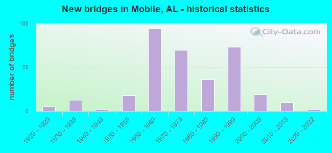
- New bridges - historical statistics
- 51920-1929
- 131930-1939
- 21940-1949
- 181950-1959
- 941960-1969
- 701970-1979
- 361980-1989
- 731990-1999
- 192000-2009
- 102010-2019
- 22020-2022
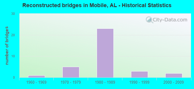
- Reconstructed bridges - Historical Statistics
- 11960-1969
- 51970-1979
- 231980-1989
- 31990-1999
- 22000-2009
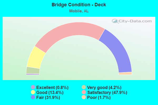
- Bridge Condition - Deck
- 0.8%Excellent
- 4.2%Very good
- 13.4%Good
- 47.9%Satisfactory
- 31.9%Fair
- 1.7%Poor
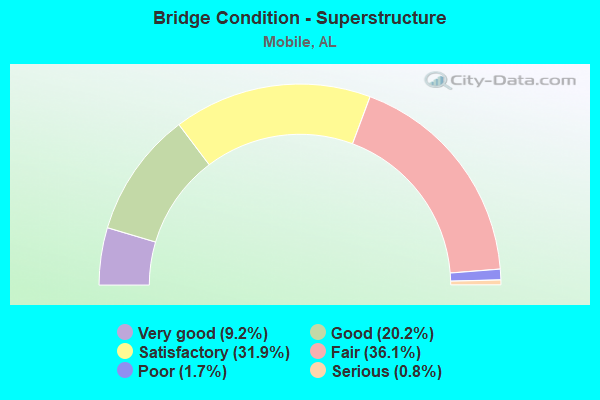
- Bridge Condition - Superstructure
- 9.2%Very good
- 20.2%Good
- 31.9%Satisfactory
- 36.1%Fair
- 1.7%Poor
- 0.8%Serious

- Bridge Condition - Substructure
- 5.0%Very good
- 23.5%Good
- 34.5%Satisfactory
- 32.8%Fair
- 2.5%Poor
- 1.7%Serious
- 0.8%Critical
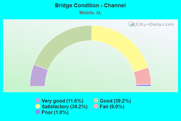
- Bridge Condition - Channel
- 11.6%Very good
- 39.2%Good
- 39.2%Satisfactory
- 9.0%Fair
- 1.0%Poor
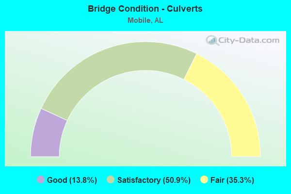
- Bridge Condition - Culverts
- 13.8%Good
- 50.9%Satisfactory
- 35.3%Fair
Find on map >> Show street view
Structure Number: 18594, Location: 0.3 MI E OF D.I.P. (Lat: 30.584722, Lng: -88.077222), Route carried "on" structure: City street , Year Built: 2001, Status: Open, Structure Length: 1.46m (4.79ft), Average Daily Traffic: 1,012 (year 2021), Truck Traffic: 1%, Average Future Daily Traffic: 1,508 (year 2041), Design Load: HS 20, Features Intersected: PERCH CREEK, Facility Carried by Structure: TERRELL RD.
Minimum Vertical Clearance: 30+ m (98+ ft), Kilometerpoint: 0.161, Lanes on structure: 2, Owner: City or Municipal Highway Agency, Approaching Roadway Width: 9.4m (30.8ft), Material/Design: Concrete, Design/Construction: Channel Beam, Number Of Spans In Main Unit: 2, Length of Maximum Span: 7.3m (24.0ft), Curb-To-Curb Width: 7.5m (24.6ft), Out-to-Out Width: 8.4m (27.6ft)
Condition: Deck: Good, Superstructure: Satisfactory, Substructure: Fair, Channel: Good, Operating Rating: 61.7 metric tons, Method Used To Determine Operating Rating: Load Factor (LF), Inventory Rating: 37.0 metric tons, Method Used To Determine Inventory Rating: Load Factor (LF), Structural Evaluation: Somewhat better than minimum adequacy, Deck Geometry: Meets minimum limits, Waterway Adequacy: Meets minimum limits, Approach Roadway Alignment: Equal to present desirable criteria, Length Of Structure Improvement: 2.14m (7.02ft), Designated Inspection Frequency: Every 24 months, Inspection Date: December 2021, Bridge Improvement Cost: $397,000, Roadway Improvement Cost: $40,000, Total Project Cost: $437,000 ( Estimate for 2022), Deck Structure Type: Concrete Cast-file-Place, Wearing Surface/Protective System: Wearing Surface: Bituminous
Find on map >> Show street view
Structure Number: 188, Location: 0.4M N OF SPRING HILL (Lat: 30.703161, Lng: -88.102964), Route carried "on" structure: City street , Year Built: 1987, Year Reconstructed: 2001, Status: Open, Structure Length: 1.34m (4.40ft), Average Daily Traffic: 12,238 (year 2022), Truck Traffic: 5%, Average Future Daily Traffic: 18,234 (year 2042), Design Load: HS 20, Features Intersected: NALL ST. DRAINAGE CANAL, Facility Carried by Structure: MOBILE STREET
Minimum Vertical Clearance: 30+ m (98+ ft), Kilometerpoint: 0.000, Lanes on structure: 3, Owner: City or Municipal Highway Agency, Approaching Roadway Width: 7.3m (24.0ft), Material/Design: Concrete, Design/Construction: Culvert, Number Of Spans In Main Unit: 2, Length of Maximum Span: 3.7m (12.1ft), Curb or Sidewalk Widths: Left: 1.5m (4.9ft), Right: 1.5m (4.9ft), Curb-To-Curb Width: 7.3m (24.0ft), Out-to-Out Width: 9.8m (32.2ft)
Condition: Channel: Good, Culverts: Satisfactory, Operating Rating: 71.5 metric tons, Method Used To Determine Operating Rating: Load Factor (LF), Inventory Rating: 42.9 metric tons, Method Used To Determine Inventory Rating: Load Factor (LF), Structural Evaluation: Equal to present minimum criteria, Deck Geometry: High priority of replacement, Waterway Adequacy: Superior to present desirable criteria, Approach Roadway Alignment: Superior to present desirable criteria, Length Of Structure Improvement: 2.02m (6.63ft), Designated Inspection Frequency: Every 24 months, Inspection Date: January 2022, Bridge Improvement Cost: $990,000, Roadway Improvement Cost: $99,000, Total Project Cost: $1,089,000 ( Estimate for 2022), Deck Structure Type: Concrete Cast-file-Place
Find on map >> Show street view
Structure Number: 18801, Location: 0.4M EAST I-10 (Lat: 30.665747, Lng: -88.043619), Route carried "on" structure: Bypass City street , Year Built: 2002, Status: Closed, Structure Length: 2.07m (6.79ft), Average Daily Traffic: 2,455 (year 2018), Truck Traffic: 30%, Average Future Daily Traffic: 3,658 (year 2038), Design Load: HS 20, Features Intersected: SOUTHERN DRAIN CANAL, Facility Carried by Structure: YEEND STREET
Minimum Vertical Clearance: 30+ m (98+ ft), Kilometerpoint: 0.000, Lanes on structure: 2, Owner: State Agenciy, Approaching Roadway Width: 7.3m (24.0ft), Material/Design: Concrete, Design/Construction: Channel Beam, Number Of Spans In Main Unit: 2, Length of Maximum Span: 10.4m (34.1ft), Curb-To-Curb Width: 8.8m (28.9ft), Out-to-Out Width: 9.4m (30.8ft)
Condition: Deck: Good, Superstructure: Very good, Substructure: Fair, Channel: Very good, Operating Rating: 74.1 metric tons, Method Used To Determine Operating Rating: Load Factor (LF), Inventory Rating: 44.5 metric tons, Method Used To Determine Inventory Rating: Load Factor (LF), Structural Evaluation: Somewhat better than minimum adequacy, Deck Geometry: Meets minimum limits, Waterway Adequacy: Better than present minimum criteria, Approach Roadway Alignment: Equal to present desirable criteria, Length Of Structure Improvement: 2.84m (9.32ft), Designated Inspection Frequency: Every 24 months, Inspection Date: January 2018, Bridge Improvement Cost: $584,000, Roadway Improvement Cost: $58,000, Total Project Cost: $642,000 ( Estimate for 2022), Deck Structure Type: Concrete Precast Panels
Find on map >> Show street view
Structure Number: 19222, Location: 0.10 MI E OF LOUISELLE ST (Lat: 30.692089, Lng: -88.079631), Route carried "on" structure: US 98, Year Built: 2004, Status: Open, Structure Length: 0.62m (2.03ft), Average Daily Traffic: 19,278 (year 2020), Truck Traffic: 2%, Average Future Daily Traffic: 28,917 (year 2040), Design Load: HS 20, Features Intersected: LITTLE STICKNEY DRAINAGE
Minimum Vertical Clearance: 30+ m (98+ ft), Kilometerpoint: 39.992, Lanes on structure: 5, Owner: State Highway Agency, Approaching Roadway Width: 18.3m (60.0ft), Material/Design: Concrete, Design/Construction: Culvert, Number Of Spans In Main Unit: 2, Length of Maximum Span: 3.0m (9.8ft)
Condition: Channel: Good, Culverts: Good, Operating Rating: 88.9 metric tons, Method Used To Determine Operating Rating: Load Factor (LF), Inventory Rating: 88.9 metric tons, Method Used To Determine Inventory Rating: Load Factor (LF), Structural Evaluation: Better than present minimum criteria, Waterway Adequacy: Better than present minimum criteria, Approach Roadway Alignment: Equal to present desirable criteria, Length Of Structure Improvement: 1.24m (4.07ft), Designated Inspection Frequency: Every 24 months, Inspection Date: December 2021, Bridge Improvement Cost: $3,230,000, Roadway Improvement Cost: $323,000, Total Project Cost: $3,553,000 ( Estimate for 2022)
Find on map >> Show street view
Structure Number: 19377, Location: 300' WEST OF NAVCO RD (Lat: 30.645833, Lng: -88.103056), Route carried "on" structure: City street , Year Built: 2001, Status: Open, Structure Length: 1.89m (6.20ft), Average Daily Traffic: 12,941 (year 2022), Truck Traffic: 4%, Average Future Daily Traffic: 19,282 (year 2042), Design Load: HS 20, Features Intersected: BOLTON BRANCH, Facility Carried by Structure: MCVAY DRIVE
Minimum Vertical Clearance: 30+ m (98+ ft), Kilometerpoint: 0.000, Lanes on structure: 5, Owner: City or Municipal Highway Agency, Approaching Roadway Width: 13.4m (44.0ft), Skew: 3 degrees, Material/Design: Concrete, Design/Construction: Culvert, Number Of Spans In Main Unit: 4, Length of Maximum Span: 3.7m (12.1ft), Curb or Sidewalk Widths: Left: 0.6m (2.0ft), Right: 0.6m (2.0ft)
Condition: Channel: Good, Culverts: Fair, Operating Rating: 66.8 metric tons, Method Used To Determine Operating Rating: Load Factor (LF), Inventory Rating: 39.9 metric tons, Method Used To Determine Inventory Rating: Load Factor (LF), Structural Evaluation: Somewhat better than minimum adequacy, Waterway Adequacy: Better than present minimum criteria, Approach Roadway Alignment: Equal to present desirable criteria, Length Of Structure Improvement: 2.62m (8.60ft), Designated Inspection Frequency: Every 24 months, Inspection Date: January 2022, Bridge Improvement Cost: $1,435,000, Roadway Improvement Cost: $144,000, Total Project Cost: $1,579,000 ( Estimate for 2022)
Find on map >> Show street view
Structure Number: 19379, Location: 567' N OF BRENTWOOD DR (Lat: 30.598253, Lng: -88.136461), Route carried "on" structure: City street , Year Built: 1996, Status: Open, Structure Length: 0.73m (2.40ft), Average Daily Traffic: 447 (year 2021), Truck Traffic: 2%, Average Future Daily Traffic: 667 (year 2041), Design Load: HS 20, Features Intersected: JANIC BAYOU, Facility Carried by Structure: CYPRESS SHORES DR
Minimum Vertical Clearance: 30+ m (98+ ft), Kilometerpoint: 0.000, Lanes on structure: 2, Owner: City or Municipal Highway Agency, Approaching Roadway Width: 6.7m (22.0ft), Material/Design: Concrete, Design/Construction: Channel Beam, Number Of Spans In Main Unit: 1, Length of Maximum Span: 7.3m (24.0ft), Curb-To-Curb Width: 7.3m (24.0ft), Out-to-Out Width: 9.3m (30.5ft)
Condition: Deck: Satisfactory, Superstructure: Satisfactory, Substructure: Fair, Channel: Fair, Operating Rating: 67.6 metric tons, Method Used To Determine Operating Rating: Load Factor (LF), Inventory Rating: 40.5 metric tons, Method Used To Determine Inventory Rating: Load Factor (LF), Structural Evaluation: Somewhat better than minimum adequacy, Deck Geometry: Meets minimum limits, Waterway Adequacy: Equal to present desirable criteria, Approach Roadway Alignment: Equal to present minimum criteria, Length Of Structure Improvement: 1.38m (4.53ft), Designated Inspection Frequency: Every 24 months, Inspection Date: December 2021, Bridge Improvement Cost: $283,000, Roadway Improvement Cost: $28,000, Total Project Cost: $311,000 ( Estimate for 2022), Deck Structure Type: Concrete Precast Panels
Find on map >> Show street view
Structure Number: 1938, Location: AT INT W/ CONCEPTION ST (Lat: 30.667664, Lng: -88.044539), Route carried "on" structure: City street , Year Built: 2004, Status: Open, Structure Length: 9.14m (29.99ft), Average Daily Traffic: 64 (year 2022), Average Future Daily Traffic: 96 (year 2042), Design Load: H 15, Features Intersected: SOUTHERN DRAIN, Facility Carried by Structure: PILLANS STREET
Minimum Vertical Clearance: 30+ m (98+ ft), Kilometerpoint: 0.000, Lanes on structure: 2, Owner: City or Municipal Highway Agency, Approaching Roadway Width: 12.8m (42.0ft), Material/Design: Concrete, Design/Construction: Culvert, Number Of Spans In Main Unit: 4, Length of Maximum Span: 2.4m (7.9ft)
Condition: Channel: Good, Culverts: Satisfactory, Operating Rating: 67.7 metric tons, Method Used To Determine Operating Rating: Load Factor (LF), Inventory Rating: 40.6 metric tons, Method Used To Determine Inventory Rating: Load Factor (LF), Structural Evaluation: Equal to present minimum criteria, Waterway Adequacy: Better than present minimum criteria, Approach Roadway Alignment: Better than present minimum criteria, Length Of Structure Improvement: 10.11m (33.17ft), Designated Inspection Frequency: Every 24 months, Inspection Date: January 2022, Bridge Improvement Cost: $18,680,000, Roadway Improvement Cost: $1,868,000, Total Project Cost: $20,548,000 ( Estimate for 2022), Wearing Surface/Protective System: Wearing Surface: Bituminous
Find on map >> Show street view
Structure Number: 19563, Location: 0.4 MI S. OLD SHELL ROAD (Lat: 30.684981, Lng: -88.190647), Route carried "on" structure: City street , Year Built: 2007, Status: Open, Structure Length: 0.75m (2.46ft), Average Daily Traffic: 15,809 (year 2021), Truck Traffic: 1%, Average Future Daily Traffic: 23,713 (year 2041), Design Load: HS 20, Features Intersected: TWELVEMILE CREEK, Facility Carried by Structure: HILLCREST ROAD
Minimum Vertical Clearance: 30+ m (98+ ft), Kilometerpoint: 1.600, Lanes on structure: 5, Owner: City or Municipal Highway Agency, Approaching Roadway Width: 20.7m (67.9ft), Material/Design: Concrete, Design/Construction: Culvert, Number Of Spans In Main Unit: 2, Length of Maximum Span: 0.0m
Condition: Channel: Very good, Culverts: Good, Operating Rating: 86.1 metric tons, Method Used To Determine Operating Rating: Load Factor (LF), Inventory Rating: 51.6 metric tons, Method Used To Determine Inventory Rating: Load Factor (LF), Structural Evaluation: Better than present minimum criteria, Waterway Adequacy: Superior to present desirable criteria, Approach Roadway Alignment: Equal to present desirable criteria, Length Of Structure Improvement: 1.39m (4.56ft), Designated Inspection Frequency: Every 24 months, Inspection Date: September 2021, Bridge Improvement Cost: $908,000, Roadway Improvement Cost: $91,000, Total Project Cost: $999,000 ( Estimate for 2022)
Find on map >> Show street view
Structure Number: 19565, Location: 1.4 MI N THREE NOTCH RD (Lat: 30.610453, Lng: -88.190772), Route carried "on" structure: City street , Year Built: 2009, Status: Open, Structure Length: 6.81m (22.34ft), Average Daily Traffic: 18,329 (year 2021), Truck Traffic: 4%, Average Future Daily Traffic: 27,311 (year 2041), Design Load: HS 20, Features Intersected: HALLS MILL CREEK, Facility Carried by Structure: HILLCREST ROAD
Minimum Vertical Clearance: 30+ m (98+ ft), Kilometerpoint: 0.000, Lanes on structure: 5, Owner: City or Municipal Highway Agency, Approaching Roadway Width: 7.9m (25.9ft), Skew: 20 degrees, Material/Design: Prestressed concrete, Design/Construction: Stringer/Multi-beam, Number Of Spans In Main Unit: 5, Length of Maximum Span: 13.7m (44.9ft), Curb or Sidewalk Widths: Left: 1.7m (5.6ft), Right: 0.0m, Curb-To-Curb Width: 7.9m (25.9ft), Out-to-Out Width: 8.7m (28.5ft)
Condition: Deck: Good, Superstructure: Good, Substructure: Fair, Channel: Satisfactory, Operating Rating: 57.1 metric tons, Method Used To Determine Operating Rating: Load Factor (LF), Inventory Rating: 36.6 metric tons, Method Used To Determine Inventory Rating: Load Factor (LF), Structural Evaluation: Somewhat better than minimum adequacy, Deck Geometry: High priority of replacement, Waterway Adequacy: Better than present minimum criteria, Approach Roadway Alignment: Equal to present desirable criteria, Length Of Structure Improvement: 7.84m (25.72ft), Designated Inspection Frequency: Every 24 months, Inspection Date: November 2021, Bridge Improvement Cost: $1,506,000, Roadway Improvement Cost: $151,000, Total Project Cost: $1,657,000 ( Estimate for 2022), Deck Structure Type: Concrete Cast-file-Place
Find on map >> Show street view
Structure Number: 19591, Location: 1.4 MI. N.OF AIRPORT BLVD (Lat: 30.691147, Lng: -88.276272), Route carried "on" structure: County highway , Year Built: 1986, Status: Open, Structure Length: 0.77m (2.53ft), Average Daily Traffic: 9,362 (year 2020), Truck Traffic: 3%, Average Future Daily Traffic: 14,313 (year 2040), Design Load: HS 20, Features Intersected: TRIB. TO PIERCE CREEK, Facility Carried by Structure: SNOW ROAD NORTH
Minimum Vertical Clearance: 30+ m (98+ ft), Kilometerpoint: 0.000, Lanes on structure: 2, Owner: County Highway Agency, Approaching Roadway Width: 8.5m (27.9ft), Skew: 1 degrees, Material/Design: Concrete, Design/Construction: Culvert, Number Of Spans In Main Unit: 2, Length of Maximum Span: 3.8m (12.5ft)
Condition: Channel: Satisfactory, Culverts: Satisfactory, Operating Rating: 71.8 metric tons, Method Used To Determine Operating Rating: Load Factor (LF), Inventory Rating: 43.1 metric tons, Method Used To Determine Inventory Rating: Load Factor (LF), Structural Evaluation: Equal to present minimum criteria, Waterway Adequacy: Better than present minimum criteria, Approach Roadway Alignment: Equal to present desirable criteria, Length Of Structure Improvement: 1.42m (4.66ft), Designated Inspection Frequency: Every 24 months, Inspection Date: June 2020, Bridge Improvement Cost: $524,000, Roadway Improvement Cost: $52,000, Total Project Cost: $576,000 ( Estimate for 2022)
Find on map >> Show street view
Structure Number: 19592, Location: 1.4 MI. S.OF AIRPORT BLVD (Lat: 30.654236, Lng: -88.265706), Route carried "on" structure: County highway , Year Built: 1986, Status: Open, Structure Length: 0.86m (2.82ft), Average Daily Traffic: 8,101 (year 2020), Truck Traffic: 2%, Average Future Daily Traffic: 12,038 (year 2040), Design Load: HS 20, Features Intersected: MILLER CREEK, Facility Carried by Structure: SNOW ROAD SOUTH
Minimum Vertical Clearance: 30+ m (98+ ft), Kilometerpoint: 0.000, Lanes on structure: 2, Owner: County Highway Agency, Approaching Roadway Width: 7.2m (23.6ft), Skew: 3 degrees, Material/Design: Concrete continuous, Design/Construction: Culvert, Number Of Spans In Main Unit: 2, Length of Maximum Span: 4.1m (13.5ft)
Condition: Channel: Good, Culverts: Satisfactory, Operating Rating: 76.3 metric tons, Method Used To Determine Operating Rating: Load Factor (LF), Inventory Rating: 45.8 metric tons, Method Used To Determine Inventory Rating: Load Factor (LF), Structural Evaluation: Equal to present minimum criteria, Waterway Adequacy: Better than present minimum criteria, Approach Roadway Alignment: Equal to present desirable criteria, Length Of Structure Improvement: 1.53m (5.02ft), Designated Inspection Frequency: Every 24 months, Inspection Date: July 2020, Bridge Improvement Cost: $565,000, Roadway Improvement Cost: $57,000, Total Project Cost: $622,000 ( Estimate for 2022)
Find on map >> Show street view
Structure Number: 19593, Location: 1.5 MI. N.OF AIRPORT BLVD (Lat: 30.693003, Lng: -88.276269), Route carried "on" structure: County highway , Year Built: 1986, Status: Open, Structure Length: 0.79m (2.59ft), Average Daily Traffic: 9,632 (year 2020), Truck Traffic: 3%, Average Future Daily Traffic: 14,313 (year 2040), Design Load: HS 20, Features Intersected: PIERCE CREEK, Facility Carried by Structure: SNOW ROAD NORTH
Minimum Vertical Clearance: 30+ m (98+ ft), Kilometerpoint: 0.000, Lanes on structure: 2, Owner: County Highway Agency, Approaching Roadway Width: 8.5m (27.9ft), Skew: 1 degrees, Material/Design: Concrete, Design/Construction: Culvert, Number Of Spans In Main Unit: 2, Length of Maximum Span: 4.0m (13.1ft)
Condition: Channel: Good, Culverts: Satisfactory, Operating Rating: 79.7 metric tons, Method Used To Determine Operating Rating: Load Factor (LF), Inventory Rating: 47.8 metric tons, Method Used To Determine Inventory Rating: Load Factor (LF), Structural Evaluation: Equal to present minimum criteria, Waterway Adequacy: Better than present minimum criteria, Approach Roadway Alignment: Equal to present desirable criteria, Length Of Structure Improvement: 1.45m (4.76ft), Designated Inspection Frequency: Every 24 months, Inspection Date: June 2020, Bridge Improvement Cost: $536,000, Roadway Improvement Cost: $54,000, Total Project Cost: $590,000 ( Estimate for 2022)
Find on map >> Show street view
Structure Number: 19798, Location: 700' N OF ST ANDREWS LN E (Lat: 30.614225, Lng: -88.123872), Route carried "on" structure: City street , Year Built: 2007, Status: Open, Structure Length: 2.81m (9.22ft), Average Daily Traffic: 34 (year 2021), Average Future Daily Traffic: 51 (year 2041), Design Load: HS 20, Features Intersected: DOG RIVER TRIBUTARY, Facility Carried by Structure: ROCHELLE LN
Minimum Vertical Clearance: 30+ m (98+ ft), Kilometerpoint: 0.000, Lanes on structure: 2, Owner: City or Municipal Highway Agency, Approaching Roadway Width: 7.3m (24.0ft), Material/Design: Concrete, Design/Construction: Channel Beam, Number Of Spans In Main Unit: 3, Length of Maximum Span: 9.7m (31.8ft), Curb-To-Curb Width: 7.3m (24.0ft), Out-to-Out Width: 8.1m (26.6ft)
Condition: Deck: Good, Superstructure: Good, Substructure: Good, Channel: Very good, Operating Rating: 69.0 metric tons, Method Used To Determine Operating Rating: Load Factor (LF), Inventory Rating: 41.4 metric tons, Method Used To Determine Inventory Rating: Load Factor (LF), Structural Evaluation: Better than present minimum criteria, Deck Geometry: Equal to present minimum criteria, Waterway Adequacy: Better than present minimum criteria, Approach Roadway Alignment: Meets minimum limits, Length Of Structure Improvement: 3.73m (12.24ft), Designated Inspection Frequency: Every 24 months, Inspection Date: December 2021, Bridge Improvement Cost: $665,000, Roadway Improvement Cost: $67,000, Total Project Cost: $732,000 ( Estimate for 2022), Deck Structure Type: Concrete Precast Panels
Find on map >> Show street view
Structure Number: 19942, Location: 1.5 Miles South Of US 98 (Lat: 30.741089, Lng: -88.225783), Route carried "on" structure: County highway 372, Year Built: 2015, Status: Open, Structure Length: 3.81m (12.50ft), Average Daily Traffic: 19,303 (year 2020), Truck Traffic: 5%, Average Future Daily Traffic: 28,683 (year 2040), Design Load: HS 20, Features Intersected: ILLINOIS CENTRAL RR, Facility Carried by Structure: SCHILLINGER ROAD
Minimum Vertical Clearance: 30+ m (98+ ft), Kilometerpoint: 53.752, Lanes on structure: 2, Owner: County Highway Agency, Approaching Roadway Width: 21.9m (71.9ft), Skew: 4 degrees, Material/Design: Prestressed concrete, Design/Construction: Stringer/Multi-beam, Number Of Spans In Main Unit: 1, Length of Maximum Span: 38.1m (125.0ft), Curb-To-Curb Width: 21.9m (71.9ft), Out-to-Out Width: 22.8m (74.8ft)
Condition: Deck: Good, Superstructure: Very good, Substructure: Good, Operating Rating: 88.9 metric tons, Method Used To Determine Operating Rating: Load Factor (LF), Inventory Rating: 48.5 metric tons, Method Used To Determine Inventory Rating: Load Factor (LF), Structural Evaluation: Better than present minimum criteria, Deck Geometry: Superior to present desirable criteria, Underclear: Superior to present desirable criteria, Approach Roadway Alignment: Better than present minimum criteria, Length Of Structure Improvement: 4.75m (15.58ft), Designated Inspection Frequency: Every 24 months, Inspection Date: August 2020, Bridge Improvement Cost: $2,408,000, Roadway Improvement Cost: $241,000, Total Project Cost: $2,649,000 ( Estimate for 2022), Deck Structure Type: Concrete Cast-file-Place
Find on map >> Show street view
Structure Number: 19964, Location: 600' E OF U.S. HWY 43 (Lat: 30.794942, Lng: -88.070092), Route carried "on" structure: City street , Year Built: 1975, Status: Open, Structure Length: 1.04m (3.41ft), Average Daily Traffic: 230 (year 2022), Truck Traffic: 50%, Average Future Daily Traffic: 343 (year 2042), Design Load: HS 20, Features Intersected: 60" INDUSTRIAL WATERLINE, Facility Carried by Structure: INDUSTRIAL PKY EXT
Minimum Vertical Clearance: 30+ m (98+ ft), Kilometerpoint: 0.000, Lanes on structure: 2, Owner: City or Municipal Highway Agency, Approaching Roadway Width: 7.4m (24.3ft), Material/Design: Concrete, Design/Construction: Channel Beam, Number Of Spans In Main Unit: 1, Length of Maximum Span: 10.4m (34.1ft), Curb-To-Curb Width: 9.0m (29.5ft), Out-to-Out Width: 9.7m (31.8ft)
Condition: Deck: Fair, Superstructure: Satisfactory, Substructure: Good, Channel: Good, Operating Rating: 51.5 metric tons, Method Used To Determine Operating Rating: Load Factor (LF), Inventory Rating: 30.8 metric tons, Method Used To Determine Inventory Rating: Load Factor (LF), Structural Evaluation: Equal to present minimum criteria, Deck Geometry: Equal to present minimum criteria, Waterway Adequacy: Equal to present minimum criteria, Approach Roadway Alignment: Equal to present minimum criteria, Length Of Structure Improvement: 1.71m (5.61ft), Designated Inspection Frequency: Every 24 months, Inspection Date: January 2022, Bridge Improvement Cost: $363,000, Roadway Improvement Cost: $36,000, Total Project Cost: $399,000 ( Estimate for 2022), Deck Structure Type: Concrete Precast Panels
Find on map >> Show street view
Structure Number: 19982, Location: 100' SOUTH OF MCVAY DRIVE (Lat: 30.644892, Lng: -88.102608), Route carried "on" structure: City street , Year Built: 2008, Status: Open, Structure Length: 1.13m (3.71ft), Average Daily Traffic: 11,239 (year 2022), Truck Traffic: 1%, Average Future Daily Traffic: 22,534 (year 2042), Design Load: HS 20, Features Intersected: BOLTON BRANCH, Facility Carried by Structure: NAVCO ROAD
Minimum Vertical Clearance: 0.00m, Kilometerpoint: 0.000, Lanes on structure: 2, Owner: City or Municipal Highway Agency, Approaching Roadway Width: 7.3m (24.0ft), Material/Design: Concrete, Design/Construction: Culvert, Number Of Spans In Main Unit: 3, Length of Maximum Span: 3.7m (12.1ft), Curb or Sidewalk Widths: Left: 1.2m (3.9ft), Right: 1.2m (3.9ft)
Condition: Channel: Good, Culverts: Satisfactory, Operating Rating: 74.8 metric tons, Method Used To Determine Operating Rating: Load Factor (LF), Inventory Rating: 44.8 metric tons, Method Used To Determine Inventory Rating: Load Factor (LF), Structural Evaluation: Equal to present minimum criteria, Waterway Adequacy: Better than present minimum criteria, Approach Roadway Alignment: Better than present minimum criteria, Length Of Structure Improvement: 1.81m (5.94ft), Designated Inspection Frequency: Every 24 months, Inspection Date: January 2022, Bridge Improvement Cost: $585,000, Roadway Improvement Cost: $59,000, Total Project Cost: $644,000 ( Estimate for 2022)
Find on map >> Show street view
Structure Number: 20002, Location: 500' EAST OF GALLIARD DR (Lat: 30.703842, Lng: -88.162086), Route carried "on" structure: City street , Year Built: 2008, Status: Open, Structure Length: 1.22m (4.00ft), Average Daily Traffic: 6,319 (year 2021), Truck Traffic: 3%, Average Future Daily Traffic: 9,415 (year 2041), Design Load: HS 20, Features Intersected: TWELVE-MILE CREEK, Facility Carried by Structure: MUSEUM DRIVE
Minimum Vertical Clearance: 30+ m (98+ ft), Kilometerpoint: 0.000, Lanes on structure: 2, Owner: City or Municipal Highway Agency, Approaching Roadway Width: 7.9m (25.9ft), Material/Design: Concrete, Design/Construction: Channel Beam, Number Of Spans In Main Unit: 1, Length of Maximum Span: 12.2m (40.0ft), Curb or Sidewalk Widths: Left: 1.3m (4.3ft), Right: 1.3m (4.3ft), Curb-To-Curb Width: 7.9m (25.9ft), Out-to-Out Width: 10.7m (35.1ft)
Condition: Deck: Very good, Superstructure: Good, Substructure: Fair, Channel: Fair, Operating Rating: 75.4 metric tons, Method Used To Determine Operating Rating: Load Factor (LF), Inventory Rating: 45.3 metric tons, Method Used To Determine Inventory Rating: Load Factor (LF), Structural Evaluation: Somewhat better than minimum adequacy, Deck Geometry: High priority of replacement, Waterway Adequacy: Equal to present minimum criteria, Approach Roadway Alignment: Better than present minimum criteria, Length Of Structure Improvement: 1.89m (6.20ft), Designated Inspection Frequency: Every 24 months, Underwater Inspection Frequency: Every 48 months, Inspection Date: October 2021, Underwater Inspection Date: January 2020, Bridge Improvement Cost: $454,000, Roadway Improvement Cost: $45,000, Total Project Cost: $499,000 ( Estimate for 2022), Deck Structure Type: Concrete Precast Panels
Find on map >> Show street view
Structure Number: 20164, Location: 0.10 S OF LAKEWIEW DR E (Lat: 30.681897, Lng: -88.214264), Route carried "on" structure: County highway 1234, Year Built: 1982, Status: Open, Structure Length: 1.04m (3.41ft), Average Daily Traffic: 883 (year 2020), Truck Traffic: 1%, Average Future Daily Traffic: 1,312 (year 2040), Design Load: H 15, Features Intersected: MILKHOUSE CREEK, Facility Carried by Structure: LAKEWIEW DR W
Minimum Vertical Clearance: 30+ m (98+ ft), Kilometerpoint: 0.000, Lanes on structure: 2, Owner: County Highway Agency, Approaching Roadway Width: 7.3m (24.0ft), Material/Design: Concrete, Design/Construction: Channel Beam, Number Of Spans In Main Unit: 1, Length of Maximum Span: 10.4m (34.1ft), Curb-To-Curb Width: 8.6m (28.2ft), Out-to-Out Width: 8.6m (28.2ft)
Condition: Deck: Satisfactory, Superstructure: Satisfactory, Substructure: Satisfactory, Channel: Poor, Operating Rating: 45.9 metric tons, Method Used To Determine Operating Rating: Load Factor (LF), Inventory Rating: 26.3 metric tons, Method Used To Determine Inventory Rating: Load Factor (LF), Structural Evaluation: Equal to present minimum criteria, Deck Geometry: Somewhat better than minimum adequacy, Waterway Adequacy: Equal to present minimum criteria, Approach Roadway Alignment: Equal to present minimum criteria, Length Of Structure Improvement: 1.71m (5.61ft), Designated Inspection Frequency: Every 24 months, Inspection Date: July 2020, Bridge Improvement Cost: $328,000, Roadway Improvement Cost: $33,000, Total Project Cost: $361,000 ( Estimate for 2022), Deck Structure Type: Concrete Precast Panels
Find on map >> Show street view
Structure Number: 20229, Location: 200' E OF KNOLLWOOD DR (Lat: 30.635556, Lng: -88.173056), Route carried "on" structure: City street , Year Built: 2009, Status: Open, Structure Length: 0.62m (2.03ft), Average Daily Traffic: 332 (year 2021), Truck Traffic: 1%, Average Future Daily Traffic: 494 (year 2041), Design Load: HS 20, Features Intersected: SPRING CREEK, Facility Carried by Structure: GRANADA AVENUE
Minimum Vertical Clearance: 30+ m (98+ ft), Kilometerpoint: 0.000, Lanes on structure: 2, Owner: City or Municipal Highway Agency, Approaching Roadway Width: 5.5m (18.0ft), Material/Design: Concrete, Design/Construction: Culvert, Number Of Spans In Main Unit: 2, Length of Maximum Span: 3.0m (9.8ft), Curb or Sidewalk Widths: Left: 0.2m (0.7ft), Right: 0.2m (0.7ft), Curb-To-Curb Width: 7.6m (24.9ft), Out-to-Out Width: 7.9m (25.9ft)
Condition: Channel: Satisfactory, Culverts: Good, Operating Rating: 88.9 metric tons, Method Used To Determine Operating Rating: Load Factor (LF), Inventory Rating: 88.9 metric tons, Method Used To Determine Inventory Rating: Load Factor (LF), Structural Evaluation: Better than present minimum criteria, Deck Geometry: Somewhat better than minimum adequacy, Waterway Adequacy: Better than present minimum criteria, Approach Roadway Alignment: Equal to present minimum criteria, Length Of Structure Improvement: 1.24m (4.07ft), Designated Inspection Frequency: Every 24 months, Inspection Date: November 2021, Bridge Improvement Cost: $287,000, Roadway Improvement Cost: $29,000, Total Project Cost: $316,000 ( Estimate for 2022)
Find on map >> Show street view
Structure Number: 2023, Location: 100' E OF I-10 (Lat: 30.648222, Lng: -88.075353), Route carried "on" structure: City street , Year Built: 2012, Status: Open, Structure Length: 4.60m (15.09ft), Average Daily Traffic: 17,854 (year 2018), Truck Traffic: 10%, Average Future Daily Traffic: 26,775 (year 2038), Design Load: HS 20, Features Intersected: C.S.X RR, Facility Carried by Structure: MICHIGAN AVENUE
Minimum Vertical Clearance: 30+ m (98+ ft), Kilometerpoint: 0.000, Lanes on structure: 4, Owner: City or Municipal Highway Agency, Approaching Roadway Width: 19.2m (63.0ft), Skew: 3 degrees, Material/Design: Prestressed concrete, Design/Construction: Stringer/Multi-beam, Number Of Spans In Main Unit: 2, Length of Maximum Span: 22.9m (75.1ft), Curb-To-Curb Width: 19.5m (64.0ft), Out-to-Out Width: 20.3m (66.6ft)
Condition: Deck: Satisfactory, Superstructure: Very good, Substructure: Good, Operating Rating: 51.9 metric tons, Method Used To Determine Operating Rating: Load Factor (LF), Inventory Rating: 36.6 metric tons, Method Used To Determine Inventory Rating: Load Factor (LF), Structural Evaluation: Better than present minimum criteria, Deck Geometry: Better than present minimum criteria, Underclear: Meets minimum limits, Approach Roadway Alignment: Equal to present desirable criteria, Length Of Structure Improvement: 5.60m (18.37ft), Designated Inspection Frequency: Every 24 months, Inspection Date: March 2020, Bridge Improvement Cost: $2,534,000, Roadway Improvement Cost: $253,000, Total Project Cost: $2,787,000 ( Estimate for 2022), Deck Structure Type: Concrete Cast-file-Place
Find on map >> Show street view
Structure Number: 20365, Location: 0.5 ML S AIRPORT BLVD (Lat: 30.669436, Lng: -88.242431), Route carried "on" structure: County highway 5625, Year Built: 2009, Status: Open, Structure Length: 1.81m (5.94ft), Average Daily Traffic: 5,721 (year 2020), Truck Traffic: 4%, Average Future Daily Traffic: 8,501 (year 2040), Design Load: HS 20, Features Intersected: MILLER CREEK, Facility Carried by Structure: AIR TERMINAL DRIVE
Minimum Vertical Clearance: 30+ m (98+ ft), Kilometerpoint: 0.000, Lanes on structure: 2, Owner: County Highway Agency, Approaching Roadway Width: 7.9m (25.9ft), Skew: 2 degrees, Material/Design: Concrete continuous, Design/Construction: Culvert, Number Of Spans In Main Unit: 5, Length of Maximum Span: 3.4m (11.2ft)
Condition: Channel: Very good, Culverts: Good, Operating Rating: 88.9 metric tons, Method Used To Determine Operating Rating: Load Factor (LF), Inventory Rating: 61.3 metric tons, Method Used To Determine Inventory Rating: Load Factor (LF), Structural Evaluation: Better than present minimum criteria, Waterway Adequacy: Equal to present desirable criteria, Approach Roadway Alignment: Equal to present desirable criteria, Length Of Structure Improvement: 2.53m (8.30ft), Designated Inspection Frequency: Every 24 months, Inspection Date: July 2020, Bridge Improvement Cost: $919,000, Roadway Improvement Cost: $92,000, Total Project Cost: $1,011,000 ( Estimate for 2022)
Find on map >> Show street view
Structure Number: 20528, Location: 87' E CL SPRINGDALE BLVD (Lat: 30.682997, Lng: -88.123072), Route carried "on" structure: City street , Year Built: 1962, Year Reconstructed: 2012, Status: Open, Structure Length: 1.03m (3.38ft), Average Daily Traffic: 3,663 (year 2022), Average Future Daily Traffic: 5,458 (year 2042), Design Load: HS 20, Features Intersected: RANGELINE DITCH, Facility Carried by Structure: EMOGENE ST
Minimum Vertical Clearance: 30+ m (98+ ft), Kilometerpoint: 0.000, Lanes on structure: 2, Owner: City or Municipal Highway Agency, Approaching Roadway Width: 6.2m (20.3ft), Material/Design: Concrete, Design/Construction: Channel Beam, Number Of Spans In Main Unit: 1, Length of Maximum Span: 9.2m (30.2ft), Curb or Sidewalk Widths: Left: 1.4m (4.6ft), Right: 1.4m (4.6ft), Curb-To-Curb Width: 8.6m (28.2ft), Out-to-Out Width: 11.7m (38.4ft)
Condition: Deck: Excellent, Superstructure: Good, Substructure: Good, Channel: Very good, Operating Rating: 74.1 metric tons, Method Used To Determine Operating Rating: Load Factor (LF), Inventory Rating: 44.5 metric tons, Method Used To Determine Inventory Rating: Load Factor (LF), Structural Evaluation: Better than present minimum criteria, Deck Geometry: Meets minimum limits, Waterway Adequacy: Equal to present desirable criteria, Approach Roadway Alignment: Equal to present desirable criteria, Length Of Structure Improvement: 1.71m (5.61ft), Designated Inspection Frequency: Every 24 months, Inspection Date: January 2022, Bridge Improvement Cost: $445,000, Roadway Improvement Cost: $45,000, Total Project Cost: $490,000 ( Estimate for 2022), Deck Structure Type: Concrete Precast Panels
Find on map >> Show street view
Structure Number: 20578, Location: 990' NORTH OF HITT RD (Lat: 30.670525, Lng: -88.207631), Route carried "on" structure: City street , Year Built: 2011, Status: Open, Structure Length: 1.22m (4.00ft), Average Daily Traffic: 16,966 (year 2021), Truck Traffic: 4%, Average Future Daily Traffic: 25,279 (year 2041), Design Load: HS 20, Features Intersected: MILKHOUSE CREEK, Facility Carried by Structure: CODY RD N
Minimum Vertical Clearance: 30+ m (98+ ft), Kilometerpoint: 0.000, Lanes on structure: 3, Owner: City or Municipal Highway Agency, Approaching Roadway Width: 11.1m (36.4ft), Material/Design: Concrete, Design/Construction: Channel Beam, Number Of Spans In Main Unit: 1, Length of Maximum Span: 12.2m (40.0ft), Curb-To-Curb Width: 14.9m (48.9ft), Out-to-Out Width: 14.9m (48.9ft)
Condition: Deck: Good, Superstructure: Good, Substructure: Good, Channel: Good, Operating Rating: 70.2 metric tons, Method Used To Determine Operating Rating: Load Factor (LF), Inventory Rating: 42.2 metric tons, Method Used To Determine Inventory Rating: Load Factor (LF), Structural Evaluation: Better than present minimum criteria, Deck Geometry: Equal to present minimum criteria, Waterway Adequacy: Better than present minimum criteria, Approach Roadway Alignment: Equal to present desirable criteria, Length Of Structure Improvement: 1.89m (6.20ft), Designated Inspection Frequency: Every 24 months, Inspection Date: October 2021, Bridge Improvement Cost: $636,000, Roadway Improvement Cost: $64,000, Total Project Cost: $700,000 ( Estimate for 2022), Deck Structure Type: Concrete Precast Panels
Find on map >> Show street view
Structure Number: 2059, Location: 1/4 WEST OF HWY 43 (Lat: 33.529886, Lng: -87.658358), Route carried "on" structure: County highway 194, Year Built: 2012, Status: Open, Structure Length: 1.04m (3.41ft), Average Daily Traffic: 100 (year 2020), Average Future Daily Traffic: 110 (year 2040), Design Load: HS 20, Features Intersected: BARBEE CREEK, Facility Carried by Structure: JOE TAYLOR ROAD
Minimum Vertical Clearance: 30+ m (98+ ft), Kilometerpoint: 0.000, Lanes on structure: 2, Owner: County Highway Agency, Approaching Roadway Width: 6.7m (22.0ft), Material/Design: Concrete, Design/Construction: Channel Beam, Number Of Spans In Main Unit: 1, Length of Maximum Span: 10.4m (34.1ft), Curb-To-Curb Width: 8.5m (27.9ft), Out-to-Out Width: 9.3m (30.5ft)
Condition: Deck: Very good, Superstructure: Very good, Substructure: Good, Channel: Very good, Operating Rating: 74.1 metric tons, Method Used To Determine Operating Rating: Load Factor (LF), Inventory Rating: 44.5 metric tons, Method Used To Determine Inventory Rating: Load Factor (LF), Structural Evaluation: Better than present minimum criteria, Deck Geometry: Better than present minimum criteria, Waterway Adequacy: Equal to present desirable criteria, Approach Roadway Alignment: Equal to present desirable criteria, Length Of Structure Improvement: 1.71m (5.61ft), Designated Inspection Frequency: Every 24 months, Inspection Date: January 2022, Bridge Improvement Cost: $351,000, Roadway Improvement Cost: $35,000, Total Project Cost: $386,000 ( Estimate for 2022), Deck Structure Type: Concrete Precast Panels
Find on map >> Show street view
Structure Number: 20785, Location: 0.4 MI E OF HILLCREST RD (Lat: 30.606658, Lng: -88.188661), Route carried "on" structure: City street , Year Built: 2012, Status: Open, Structure Length: 0.94m (3.08ft), Average Daily Traffic: 11,865 (year 2021), Truck Traffic: 4%, Average Future Daily Traffic: 17,678 (year 2041), Design Load: HS 20, Features Intersected: UNNAMED CREEK, Facility Carried by Structure: NEVIUS RD
Minimum Vertical Clearance: 30+ m (98+ ft), Kilometerpoint: 0.000, Lanes on structure: 2, Owner: City or Municipal Highway Agency, Approaching Roadway Width: 10.5m (34.4ft), Material/Design: Concrete, Design/Construction: Culvert, Number Of Spans In Main Unit: 3, Length of Maximum Span: 3.0m (9.8ft)
Condition: Channel: Very good, Culverts: Satisfactory, Operating Rating: 88.9 metric tons, Method Used To Determine Operating Rating: Load Factor (LF), Inventory Rating: 88.9 metric tons, Method Used To Determine Inventory Rating: Load Factor (LF), Structural Evaluation: Equal to present minimum criteria, Waterway Adequacy: Superior to present desirable criteria, Approach Roadway Alignment: Equal to present desirable criteria, Length Of Structure Improvement: 1.62m (5.31ft), Designated Inspection Frequency: Every 24 months, Inspection Date: December 2021, Bridge Improvement Cost: $2,037,000, Roadway Improvement Cost: $204,000, Total Project Cost: $2,241,000 ( Estimate for 2022)
Find on map >> Show street view
Structure Number: 2082, Location: 1.19 MI S OF COTTAGE HILL (Lat: 30.623528, Lng: -88.223800), Route carried "on" structure: County highway 1283, Year Built: 2013, Status: Open, Structure Length: 3.66m (12.01ft), Average Daily Traffic: 4,444 (year 2020), Truck Traffic: 3%, Average Future Daily Traffic: 6,604 (year 2040), Design Load: HS 20, Features Intersected: HALLS MILL CREEK, Facility Carried by Structure: LEROY STEVENS ROAD
Minimum Vertical Clearance: 30+ m (98+ ft), Kilometerpoint: 0.000, Lanes on structure: 2, Owner: County Highway Agency, Approaching Roadway Width: 7.3m (24.0ft), Material/Design: Concrete, Design/Construction: Channel Beam, Number Of Spans In Main Unit: 3, Length of Maximum Span: 12.2m (40.0ft), Curb-To-Curb Width: 8.6m (28.2ft), Out-to-Out Width: 9.4m (30.8ft)
Condition: Deck: Good, Superstructure: Good, Substructure: Good, Channel: Very good, Operating Rating: 75.4 metric tons, Method Used To Determine Operating Rating: Load Factor (LF), Inventory Rating: 45.3 metric tons, Method Used To Determine Inventory Rating: Load Factor (LF), Structural Evaluation: Better than present minimum criteria, Deck Geometry: Meets minimum limits, Waterway Adequacy: Equal to present desirable criteria, Approach Roadway Alignment: Superior to present desirable criteria, Length Of Structure Improvement: 4.58m (15.03ft), Designated Inspection Frequency: Every 24 months, Inspection Date: July 2020, Bridge Improvement Cost: $942,000, Roadway Improvement Cost: $94,000, Total Project Cost: $1,036,000 ( Estimate for 2022), Deck Structure Type: Concrete Precast Panels
Find on map >> Show street view
Structure Number: 20834, Location: .4 MILES W NATCHEZ TRACE (Lat: 30.855944, Lng: -88.334003), Route carried "on" structure: County highway 63, Year Built: 2017, Status: Open, Structure Length: 10.36m (33.99ft), Average Daily Traffic: 2,015 (year 2020), Truck Traffic: 6%, Average Future Daily Traffic: 2,994 (year 2040), Design Load: HS 20, Features Intersected: BIG CREEK LAKE, Facility Carried by Structure: WILMER GEORGETOWN
Minimum Vertical Clearance: 30+ m (98+ ft), Kilometerpoint: 0.010, Lanes on structure: 2, Owner: County Highway Agency, Approaching Roadway Width: 12.7m (41.7ft), Material/Design: Prestressed concrete, Design/Construction: Stringer/Multi-beam, Number Of Spans In Main Unit: 9, Length of Maximum Span: 12.2m (40.0ft), Curb-To-Curb Width: 12.1m (39.7ft), Out-to-Out Width: 12.9m (42.3ft)
Condition: Deck: Very good, Superstructure: Very good, Substructure: Good, Channel: Good, Operating Rating: 56.5 metric tons, Method Used To Determine Operating Rating: Load Factor (LF), Inventory Rating: 33.8 metric tons, Method Used To Determine Inventory Rating: Load Factor (LF), Structural Evaluation: Better than present minimum criteria, Deck Geometry: Somewhat better than minimum adequacy, Waterway Adequacy: Better than present minimum criteria, Approach Roadway Alignment: Better than present minimum criteria, Length Of Structure Improvement: 11.28m (37.01ft), Designated Inspection Frequency: Every 24 months, Inspection Date: August 2020, Bridge Improvement Cost: $3,248,000, Roadway Improvement Cost: $325,000, Total Project Cost: $3,573,000 ( Estimate for 2022), Deck Structure Type: Concrete Cast-file-Place
Find on map >> Show street view
Structure Number: 20835, Location: 0.9 MI N OF BLB LMTS (Lat: 34.783400, Lng: -86.672600), Route carried "on" structure: County highway 23, Year Built: 2017, Status: Open, Structure Length: 12.74m (41.80ft), Average Daily Traffic: 13,218 (year 2020), Truck Traffic: 4%, Average Future Daily Traffic: 19,641 (year 2040), Design Load: HS 20, Features Intersected: CARLS CREEK, Facility Carried by Structure: PADGETT SWITCH RD
Minimum Vertical Clearance: 30+ m (98+ ft), Kilometerpoint: 0.010, Lanes on structure: 2, Owner: County Highway Agency, Approaching Roadway Width: 9.4m (30.8ft), Material/Design: Prestressed concrete, Design/Construction: Stringer/Multi-beam, Number Of Spans In Main Unit: 7, Length of Maximum Span: 18.3m (60.0ft), Curb-To-Curb Width: 12.2m (40.0ft), Out-to-Out Width: 13.0m (42.7ft)
Condition: Deck: Very good, Superstructure: Very good, Substructure: Very good, Channel: Good, Operating Rating: 80.0 metric tons, Method Used To Determine Operating Rating: Load Factor (LF), Inventory Rating: 42.1 metric tons, Method Used To Determine Inventory Rating: Load Factor (LF), Structural Evaluation: Equal to present desirable criteria, Deck Geometry: Somewhat better than minimum adequacy, Waterway Adequacy: Better than present minimum criteria, Approach Roadway Alignment: Equal to present minimum criteria, Length Of Structure Improvement: 13.57m (44.52ft), Designated Inspection Frequency: Every 24 months, Inspection Date: April 2020, Bridge Improvement Cost: $3,908,000, Roadway Improvement Cost: $391,000, Total Project Cost: $4,299,000 ( Estimate for 2022), Deck Structure Type: Concrete Cast-file-Place
Find on map >> Show street view
Structure Number: 20867, Location: 0.4M EAST I-10 (Lat: 30.666717, Lng: -88.044103), Route carried "on" structure: City street , Year Built: 2014, Status: Open, Structure Length: 2.44m (8.01ft), Average Daily Traffic: 100 (year 2021), Truck Traffic: 50%, Average Future Daily Traffic: 153 (year 2041), Design Load: HS 20, Features Intersected: Southern Drain Canal, Facility Carried by Structure: Baker St. Ext.
Minimum Vertical Clearance: 30+ m (98+ ft), Kilometerpoint: 0.000, Lanes on structure: 2, Owner: City or Municipal Highway Agency, Approaching Roadway Width: 11.0m (36.1ft), Material/Design: Prestressed concrete, Design/Construction: Stringer/Multi-beam, Number Of Spans In Main Unit: 1, Length of Maximum Span: 23.1m (75.8ft), Curb-To-Curb Width: 11.0m (36.1ft), Out-to-Out Width: 11.7m (38.4ft)
Condition: Deck: Good, Superstructure: Good, Substructure: Good, Channel: Very good, Operating Rating: 81.2 metric tons, Method Used To Determine Operating Rating: Load Factor (LF), Inventory Rating: 48.6 metric tons, Method Used To Determine Inventory Rating: Load Factor (LF), Structural Evaluation: Better than present minimum criteria, Deck Geometry: Superior to present desirable criteria, Waterway Adequacy: Better than present minimum criteria, Approach Roadway Alignment: Equal to present desirable criteria, Length Of Structure Improvement: 3.31m (10.86ft), Designated Inspection Frequency: Every 24 months, Inspection Date: April 2021, Bridge Improvement Cost: $861,000, Roadway Improvement Cost: $86,000, Total Project Cost: $947,000 ( Estimate for 2022), Deck Structure Type: Concrete Cast-file-Place
Find on map >> Show street view
Structure Number: 21243, Location: 2 MI N OF THREE NOTCH RD (Lat: 30.617297, Lng: -88.224681), Route carried "on" structure: County highway 31, Year Built: 2016, Status: Open, Structure Length: 7.25m (23.79ft), Average Daily Traffic: 13,877 (year 2020), Truck Traffic: 12%, Average Future Daily Traffic: 20,620 (year 2040), Design Load: HS 20, Features Intersected: HALLS MILL CREEK, Facility Carried by Structure: SCHILLINGER ROAD S
Minimum Vertical Clearance: 30+ m (98+ ft), Kilometerpoint: 0.000, Lanes on structure: 5, Owner: County Highway Agency, Approaching Roadway Width: 21.9m (71.9ft), Skew: 5 degrees, Material/Design: Prestressed concrete, Design/Construction: Stringer/Multi-beam, Number Of Spans In Main Unit: 4, Length of Maximum Span: 18.3m (60.0ft), Curb-To-Curb Width: 21.9m (71.9ft), Out-to-Out Width: 22.8m (74.8ft)
Condition: Deck: Good, Superstructure: Very good, Substructure: Very good, Channel: Very good, Operating Rating: 69.3 metric tons, Method Used To Determine Operating Rating: Load Factor (LF), Inventory Rating: 42.3 metric tons, Method Used To Determine Inventory Rating: Load Factor (LF), Structural Evaluation: Equal to present desirable criteria, Deck Geometry: Meets minimum limits, Waterway Adequacy: Equal to present desirable criteria, Approach Roadway Alignment: Equal to present desirable criteria, Length Of Structure Improvement: 8.28m (27.17ft), Designated Inspection Frequency: Every 24 months, Inspection Date: July 2020, Bridge Improvement Cost: $4,199,000, Roadway Improvement Cost: $420,000, Total Project Cost: $4,619,000 ( Estimate for 2022), Deck Structure Type: Concrete Cast-file-Place
Find on map >> Show street view
Structure Number: 21332, Location: _0.15 MI EAST OF I-10 (Lat: 30.670322, Lng: -88.043178), Route carried "on" structure: City street , Year Built: 2009, Status: Open, Structure Length: 23.37m (76.67ft), Average Daily Traffic: 2,500 (year 2021), Truck Traffic: 60%, Average Future Daily Traffic: 3,725 (year 2041), Design Load: HS 20, Features Intersected: CSX RR, Facility Carried by Structure: _VIRGINIA ST
Minimum Vertical Clearance: 30+ m (98+ ft), Kilometerpoint: 0.002, Lanes on structure: 2, Owner: State Agenciy, Approaching Roadway Width: 12.2m (40.0ft), Material/Design: Steel continuous, Design/Construction: Stringer/Multi-beam, Number Of Spans In Main Unit: 6, Length of Maximum Span: 85.4m (280.2ft), Curb-To-Curb Width: 12.2m (40.0ft), Out-to-Out Width: 13.0m (42.7ft)
Condition: Deck: Satisfactory, Superstructure: Good, Substructure: Very good, Operating Rating: 84.8 metric tons, Method Used To Determine Operating Rating: Load Factor (LF), Inventory Rating: 49.7 metric tons, Method Used To Determine Inventory Rating: Load Factor (LF), Structural Evaluation: Better than present minimum criteria, Deck Geometry: Equal to present minimum criteria, Underclear: High priority of corrective action, Approach Roadway Alignment: Equal to present desirable criteria, Length Of Structure Improvement: 23.37m (76.67ft), Designated Inspection Frequency: Every 24 months, Inspection Date: Febuary 2021, Bridge Improvement Cost: $6,730,000, Roadway Improvement Cost: $673,000, Total Project Cost: $7,403,000 ( Estimate for 2022), Deck Structure Type: Concrete Cast-file-Place
Find on map >> Show street view
Structure Number: 21337, Location: 0.7 MI S JCT US 90 (Lat: 30.685539, Lng: -88.031350), Route carried "on" structure: City street , Year Built: 2020, Status: Open, Structure Length: 1.83m (6.00ft), Average Daily Traffic: 500 (year 2020), Truck Traffic: 10%, Average Future Daily Traffic: 750 (year 2040), Features Intersected: PINTO PASS, Facility Carried by Structure: DUNLAP DRIVE
Minimum Vertical Clearance: 30+ m (98+ ft), Kilometerpoint: 0.002, Lanes on structure: 2, Owner: City or Municipal Highway Agency, Approaching Roadway Width: 8.9m (29.2ft), Skew: 2 degrees, Material/Design: Prestressed concrete, Design/Construction: Tee Beam, Number Of Spans In Main Unit: 1, Length of Maximum Span: 16.9m (55.4ft), Curb or Sidewalk Widths: Left: 0.4m (1.3ft), Right: 0.4m (1.3ft), Curb-To-Curb Width: 9.0m (29.5ft), Out-to-Out Width: 13.7m (44.9ft)
Condition: Deck: Very good, Superstructure: Very good, Substructure: Very good, Channel: Very good, Operating Rating: 88.9 metric tons, Method Used To Determine Operating Rating: Load and Resistance Factor (LRFR), Inventory Rating: 88.9 metric tons, Method Used To Determine Inventory Rating: Load and Resistance Factor (LRFR), Structural Evaluation: Equal to present desirable criteria, Deck Geometry: Somewhat better than minimum adequacy, Waterway Adequacy: Equal to present desirable criteria, Approach Roadway Alignment: Equal to present desirable criteria, Length Of Structure Improvement: 2.54m (8.33ft), Designated Inspection Frequency: Every 24 months, Inspection Date: October 2020, Bridge Improvement Cost: $785,000, Roadway Improvement Cost: $79,000, Total Project Cost: $864,000 ( Estimate for 2022), Deck Structure Type: Other
Find on map >> Show street view
Structure Number: 21418, Location: 1.4 MI N. OF I-10 (Lat: 30.501247, Lng: -88.385353), Route carried "on" structure: County highway 917, Year Built: 1967, Status: Open, Structure Length: 0.76m (2.49ft), Average Daily Traffic: 960 (year 2020), Average Future Daily Traffic: 1,427 (year 2040), Design Load: HS 20, Features Intersected: REEDY BRANCH, Facility Carried by Structure: HALL ROAD
Minimum Vertical Clearance: 30+ m (98+ ft), Kilometerpoint: 0.000, Lanes on structure: 2, Owner: County Highway Agency, Approaching Roadway Width: 5.9m (19.4ft), Material/Design: Concrete, Design/Construction: Culvert, Number Of Spans In Main Unit: 3, Length of Maximum Span: 2.4m (7.9ft)
Condition: Channel: Satisfactory, Culverts: Satisfactory, Operating Rating: 33.7 metric tons, Method Used To Determine Operating Rating: Load Factor (LF), Inventory Rating: 20.2 metric tons, Method Used To Determine Inventory Rating: Load Factor (LF), Structural Evaluation: Somewhat better than minimum adequacy, Waterway Adequacy: Better than present minimum criteria, Approach Roadway Alignment: Somewhat better than minimum adequacy, Length Of Structure Improvement: 1.41m (4.63ft), Designated Inspection Frequency: Every 24 months, Inspection Date: September 2020, Bridge Improvement Cost: $278,000, Roadway Improvement Cost: $28,000, Total Project Cost: $306,000 ( Estimate for 2022)
Find on map >> Show street view
Structure Number: 21419, Location: 1.4 MI E OF I-10 (Lat: 30.554797, Lng: -88.179503), Route carried "on" structure: County highway 30, Year Built: 1999, Status: Open, Structure Length: 1.51m (4.95ft), Average Daily Traffic: 6,781 (year 2020), Truck Traffic: 2%, Average Future Daily Traffic: 10,076 (year 2040), Design Load: HS 20, Features Intersected: RABBIT CREEK, Facility Carried by Structure: THEODORE DAWES RD
Minimum Vertical Clearance: 30+ m (98+ ft), Kilometerpoint: 0.000, Lanes on structure: 2, Owner: County Highway Agency, Approaching Roadway Width: 11.5m (37.7ft), Material/Design: Concrete, Design/Construction: Culvert, Number Of Spans In Main Unit: 4, Length of Maximum Span: 3.7m (12.1ft)
Condition: Channel: Good, Culverts: Satisfactory, Operating Rating: 44.2 metric tons, Method Used To Determine Operating Rating: Load Factor (LF), Inventory Rating: 26.4 metric tons, Method Used To Determine Inventory Rating: Load Factor (LF), Structural Evaluation: Equal to present minimum criteria, Waterway Adequacy: Equal to present desirable criteria, Approach Roadway Alignment: Equal to present desirable criteria, Length Of Structure Improvement: 2.18m (7.15ft), Designated Inspection Frequency: Every 24 months, Inspection Date: May 2020, Bridge Improvement Cost: $4,084,000, Roadway Improvement Cost: $408,000, Total Project Cost: $4,492,000 ( Estimate for 2022)
Find on map >> Show street view
Structure Number: 21498, Location: 4.7 MI S I-10 (Lat: 30.580322, Lng: -88.083253), Route carried "on" structure: State highway 163, Year Built: 2021, Status: Open, Structure Length: 10.97m (35.99ft), Average Daily Traffic: 7,077 (year 2020), Truck Traffic: 2%, Average Future Daily Traffic: 10,616 (year 2040), Design Load: HL 93, Features Intersected: Perch Creek
Minimum Vertical Clearance: 30+ m (98+ ft), Kilometerpoint: 6.346, Lanes on structure: 4, Owner: State Highway Agency, Approaching Roadway Width: 15.2m (49.9ft), Material/Design: Prestressed concrete, Design/Construction: Stringer/Multi-beam, Number Of Spans In Main Unit: 9, Length of Maximum Span: 12.2m (40.0ft), Curb or Sidewalk Widths: Left: 0.4m (1.3ft), Right: 0.4m (1.3ft), Curb-To-Curb Width: 15.2m (49.9ft), Out-to-Out Width: 16.0m (52.5ft)
Condition: Deck: Good, Superstructure: Very good, Substructure: Very good, Channel: Very good, Operating Rating: 75.6 metric tons, Method Used To Determine Operating Rating: Load and Resistance Factor (LRFR), Inventory Rating: 58.2 metric tons, Method Used To Determine Inventory Rating: Load and Resistance Factor (LRFR), Structural Evaluation: Equal to present desirable criteria, Deck Geometry: High priority of corrective action, Waterway Adequacy: Equal to present desirable criteria, Approach Roadway Alignment: Equal to present desirable criteria, Length Of Structure Improvement: 11.86m (38.91ft), Designated Inspection Frequency: Every 24 months, Underwater Inspection Frequency: Every 24 months, Inspection Date: September 2021, Underwater Inspection Date: October 2021, Bridge Improvement Cost: $4,230,000, Roadway Improvement Cost: $423,000, Total Project Cost: $4,653,000 ( Estimate for 2022), Deck Structure Type: Concrete Cast-file-Place
Find on map >> Show street view
Structure Number: 177, Location: 1.77 MI. N. MICHIGAN AVE (Lat: 30.663333, Lng: -88.068333), Route carried "under" structure: City street , Year Built: 1921, Structure Length: 0. m, Average Daily Traffic: 6,800 (year 1992), Truck Traffic: 1%, Features Intersected: BROAD STREET, Facility Carried by Structure: L*N RAILROAD
Minimum Vertical Clearance: 4.39m (14.40ft), Kilometerpoint: 1.769, Lanes under structure: 3, Material/Design: Steel, Design/Construction: Girder and Floorbeam System, Length of Maximum Span: 39.6m (129.9ft)
Find on map >> Show street view
Structure Number: 92, Location: 0.7 MI E I 65 (Lat: 30.696667, Lng: -88.113333), Route carried "under" structure: City street , Year Built: 1931, Structure Length: 0. m, Average Daily Traffic: 17,585 (year 1990), Truck Traffic: 1%, Features Intersected: OLD SHELL ROAD ., Facility Carried by Structure: ICG RR
Minimum Vertical Clearance: 4.00m (13.12ft), Kilometerpoint: 5.919, Lanes under structure: 2, Material/Design: Steel, Design/Construction: Stringer/Multi-beam, Length of Maximum Span: 21.0m (68.9ft)
Find on map >> Show street view
Structure Number: 2059, Location: 0.7 MI. E. US 43 (Lat: 30.731667, Lng: -88.051667), Route carried "under" structure: City street , Year Built: 1939, Structure Length: 0. m, Average Daily Traffic: 1,500 (year 1991), Truck Traffic: 1%, Features Intersected: BAY BRIDGE RD., Facility Carried by Structure: TERMINAL RR
Minimum Vertical Clearance: 4.00m (13.12ft), Kilometerpoint: 1.629, Lanes under structure: 2, Material/Design: Steel, Design/Construction: Stringer/Multi-beam, Length of Maximum Span: 9.1m (29.9ft)
Find on map >> Show street view
Structure Number: 7254, Location: I-65 @ AIRPORT BLVD (Lat: 30.676253, Lng: -88.127714), Route carried "under" structure: Interstate 65, Year Built: 1961, Structure Length: 0. m, Average Daily Traffic: 50,277 (year 2018), Truck Traffic: 8%, Features Intersected: I-65, Facility Carried by Structure: AIRPORT BLVD WB
Minimum Vertical Clearance: 5.21m (17.09ft), Kilometerpoint: 5.847, Lanes on structure: 3, Lanes under structure: 6, Material/Design: Concrete continuous, Design/Construction: Tee Beam, Length of Maximum Span: 23.2m (76.1ft)
Find on map >> Show street view
Structure Number: 7255, Location: I-65 @ AIRPORT BLVD (Lat: 30.676086, Lng: -88.127708), Route carried "under" structure: Interstate 65, Year Built: 1961, Structure Length: 0. m, Average Daily Traffic: 50,277 (year 2018), Truck Traffic: 15%, Features Intersected: I-65, Facility Carried by Structure: AIRPORT BLVD EB
Minimum Vertical Clearance: 5.21m (17.09ft), Kilometerpoint: 5.847, Lanes on structure: 3, Lanes under structure: 6, Material/Design: Concrete continuous, Design/Construction: Tee Beam, Length of Maximum Span: 23.2m (76.1ft)
Find on map >> Show street view
Structure Number: 786, Location: 0.5 MI N I-10 (Lat: 30.641217, Lng: -88.119314), Route carried "under" structure: Interstate 65, Year Built: 1963, Structure Length: 0. m, Average Daily Traffic: 41,155 (year 2018), Truck Traffic: 9%, Features Intersected: I-65, Facility Carried by Structure: HALLS MILL RD
Minimum Vertical Clearance: 5.14m (16.86ft), Kilometerpoint: 1.862, Lanes on structure: 2, Lanes under structure: 8, Material/Design: Concrete continuous, Design/Construction: Tee Beam, Length of Maximum Span: 26.5m (86.9ft)
Find on map >> Show street view
Structure Number: 8139, Location: 3.3 MI E US 90 (Lat: 30.616694, Lng: -88.137033), Route carried "under" structure: Interstate 10, Year Built: 1964, Structure Length: 0. m, Average Daily Traffic: 88,617 (year 2020), Truck Traffic: 11%, Features Intersected: I-10, Facility Carried by Structure: RIVERE DU CHIEN RD
Minimum Vertical Clearance: 5.00m (16.40ft), Kilometerpoint: 30.425, Lanes on structure: 6, Lanes under structure: 6, Material/Design: Concrete continuous, Design/Construction: Tee Beam, Length of Maximum Span: 20.7m (67.9ft)
Find on map >> Show street view
Structure Number: 8142, Location: I-10 @ MICHIGAN AVE (Lat: 30.650000, Lng: -88.076667), Route carried "under" structure: Interstate 10, Year Built: 1966, Structure Length: 0. m, Average Daily Traffic: 87,048 (year 2018), Truck Traffic: 13%, Features Intersected: I-10, Facility Carried by Structure: MICHIGAN AVE
Minimum Vertical Clearance: 4.79m (15.72ft), Kilometerpoint: 37.482, Lanes on structure: 4, Lanes under structure: 8, Material/Design: Concrete continuous, Design/Construction: Box Beam or Girders - Single/Spread, Length of Maximum Span: 34.1m (111.9ft)
Find on map >> Show street view
Structure Number: 8958, Location: I-10 @ SR 163 INTERCHANGE (Lat: 30.638381, Lng: -88.090803), Route carried "under" structure: Interstate 10, Year Built: 1966, Structure Length: 0. m, Average Daily Traffic: 44,097 (year 2018), Truck Traffic: 12%, Features Intersected: I-10 EB
Minimum Vertical Clearance: 6.36m (20.87ft), Kilometerpoint: 35.414, Lanes on structure: 1, Lanes under structure: 3, Material/Design: Prestressed concrete continuous, Design/Construction: Box Beam or Girders - Multiple, Length of Maximum Span: 27.7m (90.9ft)
Find on map >> Show street view
Structure Number: 8958, Location: I-10 @ SR 163 INTERCHANGE (Lat: 30.638381, Lng: -88.090803), Route carried "under" structure: Interstate 10, Year Built: 1966, Structure Length: 0. m, Features Intersected: I-10 EB
Minimum Vertical Clearance: 6.36m (20.87ft), Kilometerpoint: 35.414, Lanes on structure: 1, Lanes under structure: 3, Material/Design: Prestressed concrete continuous, Design/Construction: Box Beam or Girders - Multiple, Length of Maximum Span: 27.7m (90.9ft)
Find on map >> Show street view
Structure Number: 8959, Location: I-10 @ SR 163 INTERCHANGE (Lat: 30.640767, Lng: -88.089372), Route carried "under" structure: Ramp Interstate 10, Year Built: 1966, Structure Length: 0. m, Average Daily Traffic: 5,228 (year 2018), Truck Traffic: 12%, Features Intersected: I-10 * SR 163
Minimum Vertical Clearance: 4.91m (16.11ft), Kilometerpoint: 35.744, Lanes on structure: 1, Lanes under structure: 7, Material/Design: Prestressed concrete continuous, Design/Construction: Box Beam or Girders - Single/Spread, Length of Maximum Span: 30.5m (100.1ft)
Find on map >> Show street view
Structure Number: 8959, Location: I-10 @ SR 163 INTERCHANGE (Lat: 30.640767, Lng: -88.089372), Route carried "under" structure: Interstate 10, Year Built: 1966, Structure Length: 0. m, Average Daily Traffic: 43,524 (year 2018), Truck Traffic: 13%, Features Intersected: I-10 * SR 163
Minimum Vertical Clearance: 4.90m (16.08ft), Kilometerpoint: 35.882, Lanes on structure: 1, Lanes under structure: 1, Material/Design: Prestressed concrete continuous, Design/Construction: Box Beam or Girders - Single/Spread, Length of Maximum Span: 30.5m (100.1ft)