Bridge Statistics for Mobile, Alabama (AL)
Condition, Traffic, Stress, Structural Evaluation, Project Costs
- National Bridge Inventory (NBI) Statistics
- 342Number of bridges
- 17,884ft / 5,451mTotal length
- $2,276,753,000Total costs
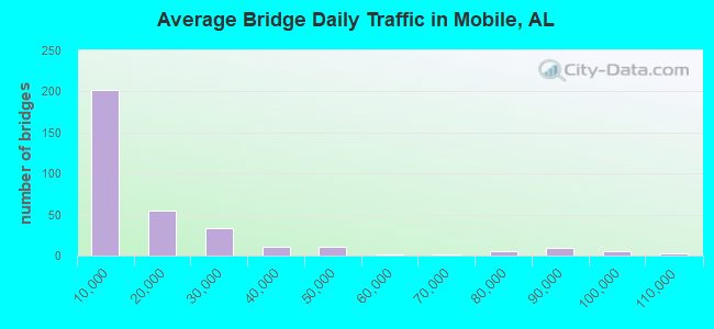
- 5,331,403Total average daily traffic
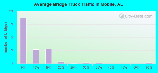
- 449,063Total average daily truck traffic
- National Bridge Inventory (NBI) Registered Bridges for Mobile
- No street view available for this location
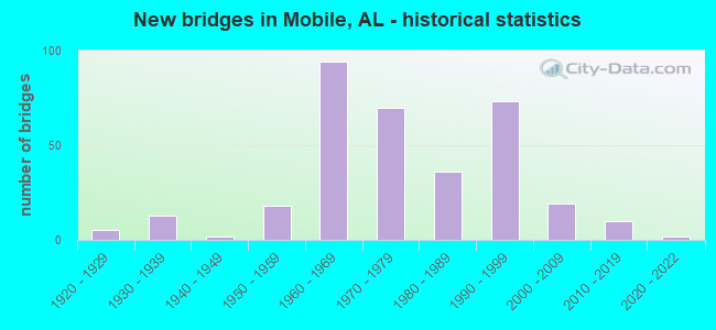
- New bridges - historical statistics
- 51920-1929
- 131930-1939
- 21940-1949
- 181950-1959
- 941960-1969
- 701970-1979
- 361980-1989
- 731990-1999
- 192000-2009
- 102010-2019
- 22020-2022
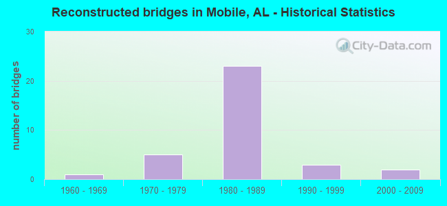
- Reconstructed bridges - Historical Statistics
- 11960-1969
- 51970-1979
- 231980-1989
- 31990-1999
- 22000-2009
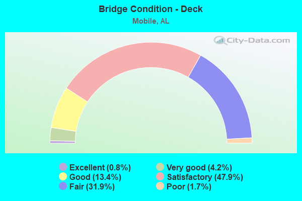
- Bridge Condition - Deck
- 0.8%Excellent
- 4.2%Very good
- 13.4%Good
- 47.9%Satisfactory
- 31.9%Fair
- 1.7%Poor
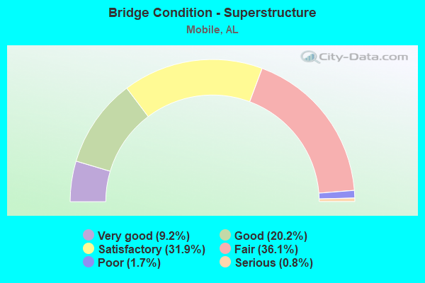
- Bridge Condition - Superstructure
- 9.2%Very good
- 20.2%Good
- 31.9%Satisfactory
- 36.1%Fair
- 1.7%Poor
- 0.8%Serious

- Bridge Condition - Substructure
- 5.0%Very good
- 23.5%Good
- 34.5%Satisfactory
- 32.8%Fair
- 2.5%Poor
- 1.7%Serious
- 0.8%Critical
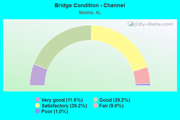
- Bridge Condition - Channel
- 11.6%Very good
- 39.2%Good
- 39.2%Satisfactory
- 9.0%Fair
- 1.0%Poor
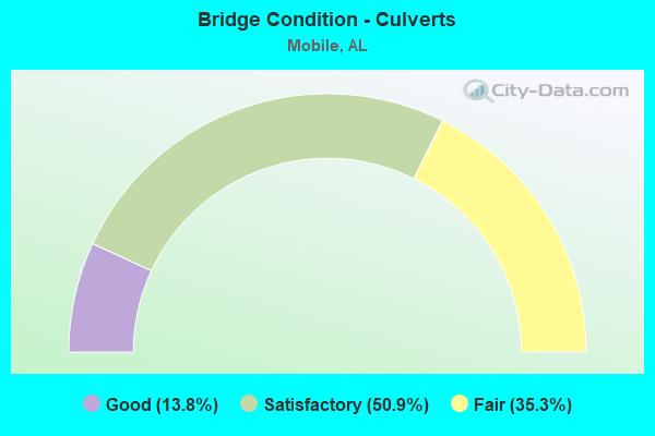
- Bridge Condition - Culverts
- 13.8%Good
- 50.9%Satisfactory
- 35.3%Fair
Find on map >> Show street view
Structure Number: 12836, Location: 0.2 MI N HAMILTON BLVD (Lat: 30.554639, Lng: -88.123472), Route carried "on" structure: State highway 193, Year Built: 1979, Status: Open, Structure Length: 1.07m (3.51ft), Average Daily Traffic: 17,447 (year 2019), Truck Traffic: 7%, Average Future Daily Traffic: 26,171 (year 2039), Design Load: HS 20, Features Intersected: ALLIGATOR BAYOU
Minimum Vertical Clearance: 30+ m (98+ ft), Kilometerpoint: 34.516, Lanes on structure: 8, Owner: State Highway Agency, Approaching Roadway Width: 15.8m (51.8ft), Skew: 16 degrees, Material/Design: Concrete, Design/Construction: Culvert, Number Of Spans In Main Unit: 2, Length of Maximum Span: 2.4m (7.9ft)
Condition: Channel: Fair, Culverts: Satisfactory, Operating Rating: 88.9 metric tons, Method Used To Determine Operating Rating: Load Factor (LF), Inventory Rating: 88.9 metric tons, Method Used To Determine Inventory Rating: Load Factor (LF), Structural Evaluation: Equal to present minimum criteria, Waterway Adequacy: Better than present minimum criteria, Approach Roadway Alignment: Better than present minimum criteria, Length Of Structure Improvement: 1.74m (5.71ft), Designated Inspection Frequency: Every 24 months, Underwater Inspection Frequency: Every 24 months, Inspection Date: October 2020, Underwater Inspection Date: October 2020, Bridge Improvement Cost: $5,973,000, Roadway Improvement Cost: $597,000, Total Project Cost: $6,570,000 ( Estimate for 2022)
Find on map >> Show street view
Structure Number: 12874, Location: 1.9 MI W I-65 (Lat: 30.633400, Lng: -88.145083), Route carried "on" structure: US 90, Year Built: 1950, Year Reconstructed: 1983, Status: Open, Structure Length: 1.92m (6.30ft), Average Daily Traffic: 26,875 (year 2019), Truck Traffic: 3%, Average Future Daily Traffic: 40,313 (year 2039), Design Load: HS 20, Features Intersected: MOORE'S CREEK
Minimum Vertical Clearance: 30+ m (98+ ft), Kilometerpoint: 34.277, Lanes on structure: 6, Owner: State Highway Agency, Approaching Roadway Width: 22.8m (74.8ft), Skew: 20 degrees, Material/Design: Concrete, Design/Construction: Culvert, Number Of Spans In Main Unit: 6, Length of Maximum Span: 3.0m (9.8ft)
Condition: Channel: Good, Culverts: Fair, Operating Rating: 88.9 metric tons, Method Used To Determine Operating Rating: Load Factor (LF), Inventory Rating: 88.9 metric tons, Method Used To Determine Inventory Rating: Load Factor (LF), Structural Evaluation: Somewhat better than minimum adequacy, Waterway Adequacy: Equal to present minimum criteria, Approach Roadway Alignment: Equal to present desirable criteria, Length Of Structure Improvement: 2.65m (8.69ft), Designated Inspection Frequency: Every 24 months, Inspection Date: July 2020, Bridge Improvement Cost: $2,879,000, Roadway Improvement Cost: $288,000, Total Project Cost: $3,167,000 ( Estimate for 2022)
Find on map >> Show street view
Structure Number: 12946, Location: 1095' S. COTTAGE HILL RD (Lat: 30.636672, Lng: -88.178722), Route carried "on" structure: City street , Year Built: 1983, Status: Open, Structure Length: 1.00m (3.28ft), Average Daily Traffic: 579 (year 2021), Truck Traffic: 1%, Average Future Daily Traffic: 863 (year 2041), Design Load: HS 15, Features Intersected: SPRING BRANCH, Facility Carried by Structure: WEST ROAD
Minimum Vertical Clearance: 30+ m (98+ ft), Kilometerpoint: 0.520, Lanes on structure: 2, Owner: City or Municipal Highway Agency, Approaching Roadway Width: 7.4m (24.3ft), Skew: 4 degrees, Material/Design: Concrete, Design/Construction: Culvert, Number Of Spans In Main Unit: 2, Length of Maximum Span: 3.0m (9.8ft), Curb-To-Curb Width: 5.4m (17.7ft), Out-to-Out Width: 26.8m (87.9ft)
Condition: Channel: Good, Culverts: Satisfactory, Operating Rating: 80.0 metric tons, Method Used To Determine Operating Rating: Load Factor (LF), Inventory Rating: 48.0 metric tons, Method Used To Determine Inventory Rating: Load Factor (LF), Structural Evaluation: Equal to present minimum criteria, Deck Geometry: High priority of replacement, Waterway Adequacy: Better than present minimum criteria, Approach Roadway Alignment: Better than present minimum criteria, Length Of Structure Improvement: 1.67m (5.48ft), Designated Inspection Frequency: Every 24 months, Inspection Date: November 2021, Bridge Improvement Cost: $1,023,000, Roadway Improvement Cost: $102,000, Total Project Cost: $1,125,000 ( Estimate for 2022)
Find on map >> Show street view
Structure Number: 12949, Location: 0.5 MI S COTTAGE HILL RD (Lat: 30.636253, Lng: -88.173972), Route carried "on" structure: City street , Year Built: 1983, Status: Open, Structure Length: 0.98m (3.22ft), Average Daily Traffic: 9,020 (year 2021), Truck Traffic: 2%, Average Future Daily Traffic: 13,440 (year 2041), Design Load: HS 15, Features Intersected: SPRING BRANCH, Facility Carried by Structure: KNOLLWOOD DRIVE
Minimum Vertical Clearance: 30+ m (98+ ft), Kilometerpoint: 1.889, Lanes on structure: 3, Owner: City or Municipal Highway Agency, Approaching Roadway Width: 10.0m (32.8ft), Skew: 3 degrees, Material/Design: Concrete, Design/Construction: Culvert, Number Of Spans In Main Unit: 2, Length of Maximum Span: 3.0m (9.8ft), Curb or Sidewalk Widths: Left: 0.2m (0.7ft), Right: 0.0m
Condition: Channel: Satisfactory, Culverts: Fair, Operating Rating: 88.9 metric tons, Method Used To Determine Operating Rating: Load Factor (LF), Inventory Rating: 56.5 metric tons, Method Used To Determine Inventory Rating: Load Factor (LF), Structural Evaluation: Somewhat better than minimum adequacy, Waterway Adequacy: Better than present minimum criteria, Approach Roadway Alignment: Equal to present desirable criteria, Length Of Structure Improvement: 1.65m (5.41ft), Designated Inspection Frequency: Every 24 months, Inspection Date: November 2021, Bridge Improvement Cost: $965,000, Roadway Improvement Cost: $97,000, Total Project Cost: $1,062,000 ( Estimate for 2022)
Find on map >> Show street view
Structure Number: 1301, Location: BURMA RD. @ BARCELONA DR. (Lat: 30.640189, Lng: -88.148733), Route carried "on" structure: City street , Year Built: 1983, Status: Open, Structure Length: 0.79m (2.59ft), Average Daily Traffic: 7,958 (year 2021), Truck Traffic: 1%, Average Future Daily Traffic: 11,858 (year 2041), Features Intersected: DRAINAGE DITCH, Facility Carried by Structure: BURMA ROAD
Minimum Vertical Clearance: 30+ m (98+ ft), Kilometerpoint: 1.170, Lanes on structure: 2, Owner: City or Municipal Highway Agency, Approaching Roadway Width: 8.2m (26.9ft), Material/Design: Concrete, Design/Construction: Culvert, Number Of Spans In Main Unit: 2, Length of Maximum Span: 3.7m (12.1ft), Curb or Sidewalk Widths: Left: 1.2m (3.9ft), Right: 1.2m (3.9ft), Curb-To-Curb Width: 8.2m (26.9ft), Out-to-Out Width: 22.3m (73.2ft)
Condition: Channel: Good, Culverts: Satisfactory, Operating Rating: 87.8 metric tons, Method Used To Determine Operating Rating: Load Factor (LF), Inventory Rating: 52.7 metric tons, Method Used To Determine Inventory Rating: Load Factor (LF), Structural Evaluation: Equal to present minimum criteria, Deck Geometry: High priority of replacement, Waterway Adequacy: Equal to present desirable criteria, Approach Roadway Alignment: Equal to present desirable criteria, Length Of Structure Improvement: 1.44m (4.72ft), Designated Inspection Frequency: Every 24 months, Inspection Date: November 2021, Bridge Improvement Cost: $608,000, Roadway Improvement Cost: $61,000, Total Project Cost: $669,000 ( Estimate for 2022)
Find on map >> Show street view
Structure Number: 13048, Location: 695' N AIRPORT BLVD (Lat: 30.678303, Lng: -88.101097), Route carried "on" structure: City street , Year Built: 1983, Status: Open, Structure Length: 0.76m (2.49ft), Average Daily Traffic: 3,732 (year 2022), Truck Traffic: 2%, Average Future Daily Traffic: 5,561 (year 2042), Design Load: HS 15, Features Intersected: WOODCOCK BRANCH, Facility Carried by Structure: MT. ISLAND DR W
Minimum Vertical Clearance: 30+ m (98+ ft), Kilometerpoint: 0.129, Lanes on structure: 2, Owner: City or Municipal Highway Agency, Approaching Roadway Width: 9.8m (32.2ft), Material/Design: Concrete, Design/Construction: Culvert, Number Of Spans In Main Unit: 2, Length of Maximum Span: 3.2m (10.5ft), Curb or Sidewalk Widths: Left: 0.2m (0.7ft), Right: 0.2m (0.7ft), Curb-To-Curb Width: 9.8m (32.2ft), Out-to-Out Width: 18.3m (60.0ft)
Condition: Channel: Satisfactory, Culverts: Satisfactory, Operating Rating: 82.9 metric tons, Method Used To Determine Operating Rating: Load Factor (LF), Inventory Rating: 49.7 metric tons, Method Used To Determine Inventory Rating: Load Factor (LF), Structural Evaluation: Equal to present minimum criteria, Deck Geometry: Meets minimum limits, Waterway Adequacy: Better than present minimum criteria, Approach Roadway Alignment: Equal to present desirable criteria, Length Of Structure Improvement: 1.41m (4.63ft), Designated Inspection Frequency: Every 24 months, Inspection Date: January 2022, Bridge Improvement Cost: $488,000, Roadway Improvement Cost: $49,000, Total Project Cost: $537,000 ( Estimate for 2022)
Find on map >> Show street view
Structure Number: 13061, Location: 1.6 MI N HAMILTON BLVD (Lat: 30.572678, Lng: -88.134117), Route carried "on" structure: State highway 193, Year Built: 1983, Status: Open, Structure Length: 17.50m (57.41ft), Average Daily Traffic: 12,561 (year 2018), Truck Traffic: 11%, Average Future Daily Traffic: 18,842 (year 2038), Design Load: HS 20, Features Intersected: RABBIT CREEK
Minimum Vertical Clearance: 30+ m (98+ ft), Kilometerpoint: 36.801, Lanes on structure: 2, Owner: State Highway Agency, Approaching Roadway Width: 11.5m (37.7ft), Material/Design: Prestressed concrete continuous, Design/Construction: Stringer/Multi-beam, Number Of Spans In Main Unit: 14, Length of Maximum Span: 12.5m (41.0ft), Curb-To-Curb Width: 12.1m (39.7ft), Out-to-Out Width: 13.0m (42.7ft)
Condition: Deck: Satisfactory, Superstructure: Satisfactory, Substructure: Satisfactory, Channel: Good, Operating Rating: 43.8 metric tons, Method Used To Determine Operating Rating: Load Factor (LF), Inventory Rating: 26.4 metric tons, Method Used To Determine Inventory Rating: Load Factor (LF), Structural Evaluation: Equal to present minimum criteria, Deck Geometry: Somewhat better than minimum adequacy, Waterway Adequacy: Equal to present desirable criteria, Approach Roadway Alignment: Equal to present desirable criteria, Length Of Structure Improvement: 18.20m (59.71ft), Designated Inspection Frequency: Every 24 months, Underwater Inspection Frequency: Every 24 months, Inspection Date: August 2020, Underwater Inspection Date: October 2020, Bridge Improvement Cost: $5,241,000, Roadway Improvement Cost: $524,000, Total Project Cost: $5,765,000 ( Estimate for 2022), Deck Structure Type: Concrete Cast-file-Place
Find on map >> Show street view
Structure Number: 13062, Location: 1.2 MI S I-10 (Lat: 30.581447, Lng: -88.140061), Route carried "on" structure: State highway 193, Year Built: 1983, Status: Open, Structure Length: 36.24m (118.90ft), Average Daily Traffic: 12,561 (year 2018), Truck Traffic: 11%, Average Future Daily Traffic: 18,842 (year 2038), Design Load: HS 20, Features Intersected: RATTLESNAKE BAYOU
Minimum Vertical Clearance: 30+ m (98+ ft), Kilometerpoint: 37.927, Lanes on structure: 2, Owner: State Highway Agency, Approaching Roadway Width: 11.1m (36.4ft), Material/Design: Prestressed concrete continuous, Design/Construction: Stringer/Multi-beam, Number Of Spans In Main Unit: 29, Length of Maximum Span: 12.5m (41.0ft), Curb-To-Curb Width: 12.1m (39.7ft), Out-to-Out Width: 13.0m (42.7ft)
Condition: Deck: Satisfactory, Superstructure: Satisfactory, Substructure: Good, Channel: Very good, Operating Rating: 44.3 metric tons, Method Used To Determine Operating Rating: Load Factor (LF), Inventory Rating: 26.5 metric tons, Method Used To Determine Inventory Rating: Load Factor (LF), Structural Evaluation: Equal to present minimum criteria, Deck Geometry: Somewhat better than minimum adequacy, Waterway Adequacy: Equal to present desirable criteria, Approach Roadway Alignment: Equal to present desirable criteria, Length Of Structure Improvement: 36.24m (118.90ft), Designated Inspection Frequency: Every 24 months, Underwater Inspection Frequency: Every 24 months, Inspection Date: August 2020, Underwater Inspection Date: October 2020, Bridge Improvement Cost: $10,437,000, Roadway Improvement Cost: $1,044,000, Total Project Cost: $11,481,000 ( Estimate for 2022), Deck Structure Type: Concrete Cast-file-Place
Find on map >> Show street view
Structure Number: 13063, Location: 0.7 MI S I-10 (Lat: 30.588919, Lng: -88.145092), Route carried "on" structure: State highway 193, Year Built: 1983, Status: Open, Structure Length: 17.31m (56.79ft), Average Daily Traffic: 12,672 (year 2019), Truck Traffic: 9%, Average Future Daily Traffic: 19,008 (year 2039), Design Load: HS 20, Features Intersected: CSX RR / TILLMANS CRN
Minimum Vertical Clearance: 30+ m (98+ ft), Kilometerpoint: 39.860, Lanes on structure: 2, Lanes under structure: 4, Owner: State Highway Agency, Approaching Roadway Width: 11.0m (36.1ft), Skew: 3 degrees, Material/Design: Steel continuous, Design/Construction: Stringer/Multi-beam, Number Of Spans In Main Unit: 7, Length of Maximum Span: 30.5m (100.1ft), Curb-To-Curb Width: 12.1m (39.7ft), Out-to-Out Width: 13.0m (42.7ft)
Condition: Deck: Satisfactory, Superstructure: Good, Substructure: Satisfactory, Operating Rating: 58.2 metric tons, Method Used To Determine Operating Rating: Load Factor (LF), Inventory Rating: 34.8 metric tons, Method Used To Determine Inventory Rating: Load Factor (LF), Structural Evaluation: Equal to present minimum criteria, Deck Geometry: Somewhat better than minimum adequacy, Underclear: Superior to present desirable criteria, Approach Roadway Alignment: Equal to present desirable criteria, Length Of Structure Improvement: 18.02m (59.12ft), Designated Inspection Frequency: Every 24 months, Inspection Date: January 2021, Bridge Improvement Cost: $5,191,000, Roadway Improvement Cost: $519,000, Total Project Cost: $5,710,000 ( Estimate for 2022), Deck Structure Type: Concrete Cast-file-Place
Find on map >> Show street view
Structure Number: 13117, Location: 1 MI S. COTTAGE HILL RD (Lat: 30.626222, Lng: -88.207736), Route carried "on" structure: County highway , Year Built: 1984, Status: Open, Structure Length: 2.20m (7.22ft), Average Daily Traffic: 8,469 (year 2020), Truck Traffic: 10%, Average Future Daily Traffic: 12,584 (year 2040), Design Load: HS 20, Features Intersected: SECOND CREEK, Facility Carried by Structure: SOLLIE ROAD
Minimum Vertical Clearance: 30+ m (98+ ft), Kilometerpoint: 2.549, Lanes on structure: 2, Owner: County Highway Agency, Approaching Roadway Width: 8.0m (26.2ft), Material/Design: Concrete, Design/Construction: Channel Beam, Number Of Spans In Main Unit: 3, Length of Maximum Span: 7.3m (24.0ft), Curb-To-Curb Width: 10.7m (35.1ft), Out-to-Out Width: 10.8m (35.4ft)
Condition: Deck: Satisfactory, Superstructure: Satisfactory, Substructure: Fair, Channel: Satisfactory, Operating Rating: 72.2 metric tons, Method Used To Determine Operating Rating: Load Factor (LF), Inventory Rating: 43.3 metric tons, Method Used To Determine Inventory Rating: Load Factor (LF), Structural Evaluation: Somewhat better than minimum adequacy, Deck Geometry: Meets minimum limits, Waterway Adequacy: Better than present minimum criteria, Approach Roadway Alignment: Equal to present desirable criteria, Length Of Structure Improvement: 3.00m (9.84ft), Designated Inspection Frequency: Every 24 months, Underwater Inspection Frequency: Every 24 months, Inspection Date: July 2020, Underwater Inspection Date: July 2020, Bridge Improvement Cost: $720,000, Roadway Improvement Cost: $72,000, Total Project Cost: $792,000 ( Estimate for 2022), Deck Structure Type: Concrete Precast Panels
Find on map >> Show street view
Structure Number: 13207, Location: 2.0 MI N THREE NOTCH ROAD (Lat: 30.615794, Lng: -88.207694), Route carried "on" structure: County highway , Year Built: 1984, Status: Open, Structure Length: 2.19m (7.19ft), Average Daily Traffic: 7,521 (year 2020), Truck Traffic: 2%, Average Future Daily Traffic: 11,176 (year 2040), Design Load: HS 20, Features Intersected: HALLS MILL CREEK, Facility Carried by Structure: SOLLIE ROAD
Minimum Vertical Clearance: 30+ m (98+ ft), Kilometerpoint: 1.999, Lanes on structure: 2, Owner: County Highway Agency, Approaching Roadway Width: 7.3m (24.0ft), Material/Design: Concrete, Design/Construction: Channel Beam, Number Of Spans In Main Unit: 3, Length of Maximum Span: 7.3m (24.0ft), Curb-To-Curb Width: 10.7m (35.1ft), Out-to-Out Width: 11.5m (37.7ft)
Condition: Deck: Satisfactory, Superstructure: Satisfactory, Substructure: Good, Channel: Good, Operating Rating: 53.5 metric tons, Method Used To Determine Operating Rating: Load Factor (LF), Inventory Rating: 32.1 metric tons, Method Used To Determine Inventory Rating: Load Factor (LF), Structural Evaluation: Equal to present minimum criteria, Deck Geometry: Meets minimum limits, Waterway Adequacy: Better than present minimum criteria, Approach Roadway Alignment: Better than present minimum criteria, Length Of Structure Improvement: 3.00m (9.84ft), Designated Inspection Frequency: Every 24 months, Inspection Date: July 2020, Bridge Improvement Cost: $760,000, Roadway Improvement Cost: $76,000, Total Project Cost: $836,000 ( Estimate for 2022), Deck Structure Type: Concrete Precast Panels
Find on map >> Show street view
Structure Number: 13209, Location: 0.1 MI E OF COCA-COLA RD (Lat: 30.618333, Lng: -88.165000), Route carried "on" structure: City street , Year Built: 1984, Status: Open, Structure Length: 1.13m (3.71ft), Average Daily Traffic: 111 (year 2021), Truck Traffic: 1%, Average Future Daily Traffic: 166 (year 2041), Design Load: HS 20, Features Intersected: CREEK, Facility Carried by Structure: MOTEL COURT
Minimum Vertical Clearance: 30+ m (98+ ft), Kilometerpoint: 0.000, Lanes on structure: 2, Owner: City or Municipal Highway Agency, Approaching Roadway Width: 6.9m (22.6ft), Material/Design: Concrete continuous, Design/Construction: Culvert, Number Of Spans In Main Unit: 3, Length of Maximum Span: 3.7m (12.1ft)
Condition: Channel: Satisfactory, Culverts: Fair, Operating Rating: 59.4 metric tons, Method Used To Determine Operating Rating: Load Factor (LF), Inventory Rating: 35.6 metric tons, Method Used To Determine Inventory Rating: Load Factor (LF), Structural Evaluation: Somewhat better than minimum adequacy, Waterway Adequacy: Better than present minimum criteria, Approach Roadway Alignment: Equal to present desirable criteria, Length Of Structure Improvement: 1.81m (5.94ft), Designated Inspection Frequency: Every 24 months, Inspection Date: December 2021, Bridge Improvement Cost: $417,000, Roadway Improvement Cost: $42,000, Total Project Cost: $459,000 ( Estimate for 2022)
Find on map >> Show street view
Structure Number: 13358, Location: 495' N AIRPORT BLVD (Lat: 30.677644, Lng: -88.104925), Route carried "on" structure: City street , Year Built: 1984, Status: Open, Structure Length: 0.79m (2.59ft), Average Daily Traffic: 21,530 (year 2022), Truck Traffic: 3%, Average Future Daily Traffic: 32,080 (year 2042), Design Load: HS 15, Features Intersected: WOODCOCK BRANCH, Facility Carried by Structure: FLORIDA STREET
Minimum Vertical Clearance: 7.56m (24.80ft), Kilometerpoint: 0.150, Lanes on structure: 2, Owner: City or Municipal Highway Agency, Approaching Roadway Width: 9.8m (32.2ft), Skew: 3 degrees, Material/Design: Concrete, Design/Construction: Culvert, Number Of Spans In Main Unit: 2, Length of Maximum Span: 3.7m (12.1ft), Curb or Sidewalk Widths: Left: 0.2m (0.7ft), Right: 0.2m (0.7ft), Curb-To-Curb Width: 9.8m (32.2ft), Out-to-Out Width: 25.2m (82.7ft)
Condition: Channel: Satisfactory, Culverts: Satisfactory, Operating Rating: 82.6 metric tons, Method Used To Determine Operating Rating: Load Factor (LF), Inventory Rating: 49.5 metric tons, Method Used To Determine Inventory Rating: Load Factor (LF), Structural Evaluation: Equal to present minimum criteria, Deck Geometry: Meets minimum limits, Waterway Adequacy: Meets minimum limits, Approach Roadway Alignment: Better than present minimum criteria, Length Of Structure Improvement: 1.44m (4.72ft), Designated Inspection Frequency: Every 24 months, Inspection Date: January 2022, Bridge Improvement Cost: $800,000, Roadway Improvement Cost: $80,000, Total Project Cost: $880,000 ( Estimate for 2022)
Find on map >> Show street view
Structure Number: 13667, Location: 0.6 MI E SCHILLENGER RD (Lat: 30.692600, Lng: -88.216300), Route carried "on" structure: City street 70, Year Built: 1985, Status: Open, Structure Length: 1.13m (3.71ft), Average Daily Traffic: 16,738 (year 2021), Truck Traffic: 4%, Average Future Daily Traffic: 24,490 (year 2041), Design Load: H 20, Features Intersected: MILKHOUSE CREEK, Facility Carried by Structure: OLD SHELL ROAD
Minimum Vertical Clearance: 30+ m (98+ ft), Kilometerpoint: 0.599, Lanes on structure: 5, Owner: City or Municipal Highway Agency, Approaching Roadway Width: 9.1m (29.9ft), Material/Design: Concrete, Design/Construction: Culvert, Number Of Spans In Main Unit: 3, Length of Maximum Span: 4.0m (13.1ft)
Condition: Channel: Satisfactory, Culverts: Good, Operating Rating: 43.5 metric tons, Method Used To Determine Operating Rating: Field evaluation and documented engineering judgment, Inventory Rating: 32.7 metric tons, Method Used To Determine Inventory Rating: Field evaluation and documented engineering judgment, Structural Evaluation: Better than present minimum criteria, Waterway Adequacy: Equal to present minimum criteria, Approach Roadway Alignment: Equal to present desirable criteria, Length Of Structure Improvement: 1.81m (5.94ft), Designated Inspection Frequency: Every 24 months, Inspection Date: October 2021, Bridge Improvement Cost: $1,314,000, Roadway Improvement Cost: $131,000, Total Project Cost: $1,445,000 ( Estimate for 2022)
Find on map >> Show street view
Structure Number: 13772, Location: 0.3 MI N HALLS MILLRD (Lat: 30.616969, Lng: -88.157006), Route carried "on" structure: City street , Year Built: 1949, Year Reconstructed: 1986, Status: Open, Structure Length: 1.31m (4.30ft), Average Daily Traffic: 4,894 (year 2021), Truck Traffic: 4%, Average Future Daily Traffic: 7,292 (year 2041), Design Load: HS 20, Features Intersected: SPRING BRANCH, Facility Carried by Structure: DEMETROPOLIS RD
Minimum Vertical Clearance: 30+ m (98+ ft), Kilometerpoint: 1.399, Lanes on structure: 2, Owner: City or Municipal Highway Agency, Approaching Roadway Width: 6.1m (20.0ft), Skew: 1 degrees, Material/Design: Concrete, Design/Construction: Culvert, Number Of Spans In Main Unit: 4, Length of Maximum Span: 3.0m (9.8ft)
Condition: Channel: Satisfactory, Culverts: Satisfactory, Operating Rating: 70.9 metric tons, Method Used To Determine Operating Rating: Load Factor (LF), Inventory Rating: 42.5 metric tons, Method Used To Determine Inventory Rating: Load Factor (LF), Structural Evaluation: Equal to present minimum criteria, Waterway Adequacy: Better than present minimum criteria, Approach Roadway Alignment: Equal to present desirable criteria, Length Of Structure Improvement: 1.98m (6.50ft), Designated Inspection Frequency: Every 24 months, Inspection Date: November 2021, Bridge Improvement Cost: $562,000, Roadway Improvement Cost: $56,000, Total Project Cost: $618,000 ( Estimate for 2022)
Find on map >> Show street view
Structure Number: 13791, Location: 4.5 MI W I-65 (Lat: 30.743847, Lng: -88.180417), Route carried "on" structure: US 98, Year Built: 1956, Year Reconstructed: 1986, Status: Open, Structure Length: 2.26m (7.41ft), Average Daily Traffic: 24,805 (year 2019), Truck Traffic: 7%, Average Future Daily Traffic: 37,208 (year 2039), Design Load: HS 20, Features Intersected: CLEAR CREEK
Minimum Vertical Clearance: 30+ m (98+ ft), Kilometerpoint: 27.515, Lanes on structure: 5, Base Highway Network: Yes, Owner: State Highway Agency, Approaching Roadway Width: 19.2m (63.0ft), Material/Design: Concrete, Design/Construction: Culvert, Number Of Spans In Main Unit: 5, Length of Maximum Span: 4.3m (14.1ft)
Condition: Channel: Satisfactory, Culverts: Satisfactory, Operating Rating: 42.7 metric tons, Method Used To Determine Operating Rating: Load Factor (LF), Inventory Rating: 25.6 metric tons, Method Used To Determine Inventory Rating: Load Factor (LF), Structural Evaluation: Equal to present minimum criteria, Waterway Adequacy: Equal to present minimum criteria, Approach Roadway Alignment: Better than present minimum criteria, Length Of Structure Improvement: 3.07m (10.07ft), Designated Inspection Frequency: Every 24 months, Inspection Date: August 2020, Bridge Improvement Cost: $1,952,000, Roadway Improvement Cost: $195,000, Total Project Cost: $2,147,000 ( Estimate for 2022)
Find on map >> Show street view
Structure Number: 13798, Location: I65 @ US 98 (Lat: 30.706203, Lng: -88.122500), Route carried "on" structure: Interstate 65, Year Built: 1960, Year Reconstructed: 1986, Status: Open, Structure Length: 13.62m (44.69ft), Average Daily Traffic: 92,362 (year 2018), Truck Traffic: 10%, Average Future Daily Traffic: 138,543 (year 2038), Design Load: HS 20, Features Intersected: ICG RR * US 98
Minimum Vertical Clearance: 30+ m (98+ ft), Kilometerpoint: 9.114, Lanes on structure: 8, Lanes under structure: 4, Base Highway Network: Yes, Owner: State Highway Agency, Approaching Roadway Width: 44.5m (146.0ft), Skew: 22 degrees, Material/Design: Concrete continuous, Design/Construction: Tee Beam, Number Of Spans In Main Unit: 6, Length of Maximum Span: 27.4m (89.9ft), Curb-To-Curb Width: 43.7m (143.4ft), Out-to-Out Width: 45.4m (149.0ft)
Condition: Deck: Fair, Superstructure: Fair, Substructure: Satisfactory, Operating Rating: 44.9 metric tons, Method Used To Determine Operating Rating: Load Factor (LF), Inventory Rating: 26.9 metric tons, Method Used To Determine Inventory Rating: Load Factor (LF), Structural Evaluation: Somewhat better than minimum adequacy, Deck Geometry: Superior to present desirable criteria, Underclear: High priority of corrective action, Approach Roadway Alignment: Equal to present desirable criteria, Length Of Structure Improvement: 14.43m (47.34ft), Designated Inspection Frequency: Every 24 months, Inspection Date: June 2020, Bridge Improvement Cost: $14,744,000, Roadway Improvement Cost: $1,474,000, Total Project Cost: $16,218,000 ( Estimate for 2022), Deck Structure Type: Concrete Cast-file-Place
Find on map >> Show street view
Structure Number: 138, Location: 0.3 MI W I 65 (Lat: 30.660219, Lng: -88.128544), Route carried "on" structure: Bypass City street , Year Built: 1986, Status: Open, Structure Length: 5.18m (16.99ft), Average Daily Traffic: 29,118 (year 2021), Truck Traffic: 2%, Average Future Daily Traffic: 43,386 (year 2041), Design Load: HS 20, Features Intersected: MONTLIMAR CREEK, Facility Carried by Structure: COTTAGE HILL ROAD
Minimum Vertical Clearance: 30+ m (98+ ft), Kilometerpoint: 2.699, Lanes on structure: 7, Owner: City or Municipal Highway Agency, Approaching Roadway Width: 27.4m (89.9ft), Skew: 10 degrees, Material/Design: Prestressed concrete continuous, Design/Construction: Stringer/Multi-beam, Number Of Spans In Main Unit: 5, Length of Maximum Span: 10.4m (34.1ft), Curb or Sidewalk Widths: Left: 1.5m (4.9ft), Right: 1.5m (4.9ft), Curb-To-Curb Width: 27.4m (89.9ft), Out-to-Out Width: 31.3m (102.7ft)
Condition: Deck: Satisfactory, Superstructure: Good, Substructure: Fair, Channel: Good, Operating Rating: 62.8 metric tons, Method Used To Determine Operating Rating: Load Factor (LF), Inventory Rating: 37.6 metric tons, Method Used To Determine Inventory Rating: Load Factor (LF), Structural Evaluation: Somewhat better than minimum adequacy, Deck Geometry: Somewhat better than minimum adequacy, Waterway Adequacy: Equal to present minimum criteria, Approach Roadway Alignment: Equal to present desirable criteria, Length Of Structure Improvement: 6.20m (20.34ft), Designated Inspection Frequency: Every 24 months, Inspection Date: December 2021, Bridge Improvement Cost: $4,338,000, Roadway Improvement Cost: $434,000, Total Project Cost: $4,772,000 ( Estimate for 2022), Deck Structure Type: Concrete Cast-file-Place
Find on map >> Show street view
Structure Number: 13806, Location: I-65 @ US 90 (Lat: 30.651764, Lng: -88.122303), Route carried "on" structure: Interstate 65, Year Built: 1961, Year Reconstructed: 1986, Status: Open, Structure Length: 8.32m (27.30ft), Average Daily Traffic: 90,572 (year 2018), Truck Traffic: 9%, Average Future Daily Traffic: 181,035 (year 2038), Design Load: HS 20, Features Intersected: US 90
Minimum Vertical Clearance: 30+ m (98+ ft), Kilometerpoint: 3.055, Lanes on structure: 8, Lanes under structure: 8, Base Highway Network: Yes, Owner: State Highway Agency, Approaching Roadway Width: 43.0m (141.1ft), Skew: 21 degrees, Material/Design: Concrete continuous, Design/Construction: Tee Beam, Number Of Spans In Main Unit: 4, Length of Maximum Span: 22.9m (75.1ft), Curb-To-Curb Width: 42.9m (140.7ft), Out-to-Out Width: 44.4m (145.7ft)
Condition: Deck: Fair, Superstructure: Fair, Substructure: Fair, Operating Rating: 42.2 metric tons, Method Used To Determine Operating Rating: Load Factor (LF), Inventory Rating: 25.2 metric tons, Method Used To Determine Inventory Rating: Load Factor (LF), Structural Evaluation: Somewhat better than minimum adequacy, Deck Geometry: Superior to present desirable criteria, Underclear: Meets minimum limits, Approach Roadway Alignment: Better than present minimum criteria, Length Of Structure Improvement: 9.32m (30.58ft), Designated Inspection Frequency: Every 24 months, Inspection Date: May 2020, Bridge Improvement Cost: $9,264,000, Roadway Improvement Cost: $926,000, Total Project Cost: $10,190,000 ( Estimate for 2022), Deck Structure Type: Concrete Cast-file-Place
Find on map >> Show street view
Structure Number: 13807, Location: 0.6 MI N US 90 (Lat: 30.661183, Lng: -88.126214), Route carried "on" structure: Interstate 65, Year Built: 1961, Year Reconstructed: 1986, Status: Open, Structure Length: 6.98m (22.90ft), Average Daily Traffic: 90,572 (year 2018), Truck Traffic: 9%, Average Future Daily Traffic: 135,858 (year 2038), Design Load: HS 20, Features Intersected: COTTAGE HILL RD
Minimum Vertical Clearance: 30+ m (98+ ft), Kilometerpoint: 4.170, Lanes on structure: 6, Lanes under structure: 8, Base Highway Network: Yes, Owner: State Highway Agency, Approaching Roadway Width: 37.8m (124.0ft), Skew: 20 degrees, Material/Design: Concrete continuous, Design/Construction: Tee Beam, Number Of Spans In Main Unit: 4, Length of Maximum Span: 19.2m (63.0ft), Curb-To-Curb Width: 36.0m (118.1ft), Out-to-Out Width: 37.8m (124.0ft)
Condition: Deck: Fair, Superstructure: Fair, Substructure: Satisfactory, Operating Rating: 40.7 metric tons, Method Used To Determine Operating Rating: Load Factor (LF), Inventory Rating: 26.6 metric tons, Method Used To Determine Inventory Rating: Load Factor (LF), Structural Evaluation: Somewhat better than minimum adequacy, Deck Geometry: Superior to present desirable criteria, Underclear: High priority of corrective action, Approach Roadway Alignment: Equal to present desirable criteria, Length Of Structure Improvement: 8.01m (26.28ft), Designated Inspection Frequency: Every 24 months, Inspection Date: June 2020, Bridge Improvement Cost: $6,813,000, Roadway Improvement Cost: $681,000, Total Project Cost: $7,494,000 ( Estimate for 2022), Deck Structure Type: Concrete Cast-file-Place
Find on map >> Show street view
Structure Number: 13809, Location: I-65 @ DAUPHIN ST (Lat: 30.688183, Lng: -88.126803), Route carried "on" structure: City street , Year Built: 1962, Year Reconstructed: 1986, Status: Open, Structure Length: 8.60m (28.22ft), Average Daily Traffic: 34,435 (year 2018), Truck Traffic: 5%, Average Future Daily Traffic: 51,653 (year 2038), Design Load: HS 20, Features Intersected: I-65, Facility Carried by Structure: DAUPHIN ST
Minimum Vertical Clearance: 30+ m (98+ ft), Kilometerpoint: 0.000, Lanes on structure: 6, Lanes under structure: 6, Owner: State Highway Agency, Approaching Roadway Width: 26.5m (86.9ft), Skew: 22 degrees, Material/Design: Concrete continuous, Design/Construction: Tee Beam, Number Of Spans In Main Unit: 4, Length of Maximum Span: 23.8m (78.1ft), Curb-To-Curb Width: 24.4m (80.1ft), Out-to-Out Width: 26.5m (86.9ft)
Condition: Deck: Fair, Superstructure: Satisfactory, Substructure: Satisfactory, Operating Rating: 36.1 metric tons, Method Used To Determine Operating Rating: Load Factor (LF), Inventory Rating: 21.6 metric tons, Method Used To Determine Inventory Rating: Load Factor (LF), Structural Evaluation: Somewhat better than minimum adequacy, Deck Geometry: Somewhat better than minimum adequacy, Underclear: Meets minimum limits, Approach Roadway Alignment: Better than present minimum criteria, Length Of Structure Improvement: 9.59m (31.46ft), Designated Inspection Frequency: Every 24 months, Inspection Date: June 2020, Bridge Improvement Cost: $5,654,000, Roadway Improvement Cost: $565,000, Total Project Cost: $6,219,000 ( Estimate for 2022), Deck Structure Type: Concrete Cast-file-Place
Find on map >> Show street view
Structure Number: 1381, Location: 0.5 MI S US 98 (Lat: 30.698414, Lng: -88.124233), Route carried "on" structure: Interstate 65, Year Built: 1962, Year Reconstructed: 1986, Status: Open, Structure Length: 5.46m (17.91ft), Average Daily Traffic: 106,136 (year 2018), Truck Traffic: 6%, Average Future Daily Traffic: 159,204 (year 2038), Design Load: HS 20, Features Intersected: OLD SHELL RD
Minimum Vertical Clearance: 30+ m (98+ ft), Kilometerpoint: 8.322, Lanes on structure: 7, Lanes under structure: 2, Base Highway Network: Yes, Owner: State Highway Agency, Approaching Roadway Width: 40.8m (133.9ft), Skew: 20 degrees, Material/Design: Concrete continuous, Design/Construction: Tee Beam, Number Of Spans In Main Unit: 3, Length of Maximum Span: 20.7m (67.9ft), Curb-To-Curb Width: 40.2m (131.9ft), Out-to-Out Width: 41.7m (136.8ft)
Condition: Deck: Fair, Superstructure: Satisfactory, Substructure: Satisfactory, Operating Rating: 55.0 metric tons, Method Used To Determine Operating Rating: Load Factor (LF), Inventory Rating: 32.9 metric tons, Method Used To Determine Inventory Rating: Load Factor (LF), Structural Evaluation: Equal to present minimum criteria, Deck Geometry: Superior to present desirable criteria, Underclear: Better than present minimum criteria, Approach Roadway Alignment: Equal to present desirable criteria, Length Of Structure Improvement: 6.49m (21.29ft), Designated Inspection Frequency: Every 24 months, Inspection Date: May 2020, Bridge Improvement Cost: $6,049,000, Roadway Improvement Cost: $605,000, Total Project Cost: $6,654,000 ( Estimate for 2022), Deck Structure Type: Concrete Cast-file-Place
Find on map >> Show street view
Structure Number: 13811, Location: 0.2 MI S US 98 (Lat: 30.703442, Lng: -88.123167), Route carried "on" structure: Interstate 65, Year Built: 1962, Year Reconstructed: 1986, Status: Open, Structure Length: 6.43m (21.10ft), Average Daily Traffic: 106,136 (year 2018), Truck Traffic: 6%, Average Future Daily Traffic: 159,204 (year 2038), Design Load: HS 20, Features Intersected: SPRING HILL AVE
Minimum Vertical Clearance: 30+ m (98+ ft), Kilometerpoint: 8.884, Lanes on structure: 7, Lanes under structure: 5, Base Highway Network: Yes, Owner: State Highway Agency, Approaching Roadway Width: 40.8m (133.9ft), Skew: 21 degrees, Material/Design: Concrete continuous, Design/Construction: Tee Beam, Number Of Spans In Main Unit: 3, Length of Maximum Span: 24.4m (80.1ft), Curb-To-Curb Width: 40.8m (133.9ft), Out-to-Out Width: 41.7m (136.8ft)
Condition: Deck: Fair, Superstructure: Fair, Substructure: Satisfactory, Operating Rating: 39.3 metric tons, Method Used To Determine Operating Rating: Load Factor (LF), Inventory Rating: 23.5 metric tons, Method Used To Determine Inventory Rating: Load Factor (LF), Structural Evaluation: Somewhat better than minimum adequacy, Deck Geometry: Superior to present desirable criteria, Underclear: High priority of corrective action, Approach Roadway Alignment: Equal to present desirable criteria, Length Of Structure Improvement: 7.47m (24.51ft), Designated Inspection Frequency: Every 24 months, Inspection Date: May 2020, Bridge Improvement Cost: $6,967,000, Roadway Improvement Cost: $697,000, Total Project Cost: $7,664,000 ( Estimate for 2022), Deck Structure Type: Concrete Cast-file-Place
Find on map >> Show street view
Structure Number: 13812, Location: 1 MI N US 98 (Lat: 30.719831, Lng: -88.120517), Route carried "on" structure: Interstate 65, Year Built: 1962, Year Reconstructed: 1986, Status: Open, Structure Length: 1.28m (4.20ft), Average Daily Traffic: 86,547 (year 2018), Truck Traffic: 10%, Average Future Daily Traffic: 129,821 (year 2038), Design Load: HS 20, Features Intersected: BRANCH
Minimum Vertical Clearance: 30+ m (98+ ft), Kilometerpoint: 10.713, Lanes on structure: 10, Base Highway Network: Yes, Owner: State Highway Agency, Approaching Roadway Width: 36.0m (118.1ft), Skew: 10 degrees, Material/Design: Concrete, Design/Construction: Culvert, Number Of Spans In Main Unit: 4, Length of Maximum Span: 3.0m (9.8ft)
Condition: Channel: Fair, Culverts: Fair, Operating Rating: 44.8 metric tons, Method Used To Determine Operating Rating: Load Factor (LF), Inventory Rating: 26.9 metric tons, Method Used To Determine Inventory Rating: Load Factor (LF), Structural Evaluation: Somewhat better than minimum adequacy, Waterway Adequacy: Equal to present minimum criteria, Approach Roadway Alignment: Equal to present desirable criteria, Length Of Structure Improvement: 1.95m (6.40ft), Designated Inspection Frequency: Every 24 months, Inspection Date: March 2020, Bridge Improvement Cost: $3,001,000, Roadway Improvement Cost: $300,000, Total Project Cost: $3,301,000 ( Estimate for 2022)
Find on map >> Show street view
Structure Number: 13975, Location: 0.3 MI N COTTAGE HILL RD (Lat: 30.662383, Lng: -88.133225), Route carried "on" structure: City street , Year Built: 1986, Status: Open, Structure Length: 1.32m (4.33ft), Average Daily Traffic: 15,356 (year 2021), Truck Traffic: 4%, Average Future Daily Traffic: 22,881 (year 2041), Design Load: HS 20, Features Intersected: BOLTON BRANCH, Facility Carried by Structure: MONTLIMAR DRIVE
Minimum Vertical Clearance: 30+ m (98+ ft), Kilometerpoint: 0.319, Lanes on structure: 6, Owner: City or Municipal Highway Agency, Approaching Roadway Width: 20.1m (65.9ft), Skew: 21 degrees, Material/Design: Concrete, Design/Construction: Culvert, Number Of Spans In Main Unit: 4, Length of Maximum Span: 3.0m (9.8ft), Curb or Sidewalk Widths: Left: 1.5m (4.9ft), Right: 0.2m (0.7ft)
Condition: Channel: Satisfactory, Culverts: Fair, Operating Rating: 33.7 metric tons, Method Used To Determine Operating Rating: Load Factor (LF), Inventory Rating: 20.1 metric tons, Method Used To Determine Inventory Rating: Load Factor (LF), Structural Evaluation: Somewhat better than minimum adequacy, Waterway Adequacy: Better than present minimum criteria, Approach Roadway Alignment: Better than present minimum criteria, Length Of Structure Improvement: 1.99m (6.53ft), Designated Inspection Frequency: Every 24 months, Inspection Date: October 2021, Bridge Improvement Cost: $1,692,000, Roadway Improvement Cost: $169,000, Total Project Cost: $1,861,000 ( Estimate for 2022)
Find on map >> Show street view
Structure Number: 14005, Location: 781 N. E. WATER STREET (Lat: 30.701344, Lng: -88.041892), Route carried "on" structure: City street , Year Built: 1986, Status: Open, Structure Length: 43.43m (142.49ft), Average Daily Traffic: 8,729 (year 2020), Truck Traffic: 50%, Average Future Daily Traffic: 12,953 (year 2040), Design Load: HS 20, Features Intersected: CSX R.R., Facility Carried by Structure: ACCESS AL ST DOCK
Minimum Vertical Clearance: 30+ m (98+ ft), Kilometerpoint: 0.150, Lanes on structure: 2, Lanes under structure: 2, Owner: City or Municipal Highway Agency, Approaching Roadway Width: 13.7m (44.9ft), Skew: 9 degrees, Material/Design: Steel, Design/Construction: Stringer/Multi-beam, Number Of Spans In Main Unit: 8, Number Of Approach Spans: 16, Length of Maximum Span: 36.9m (121.1ft), Curb-To-Curb Width: 12.2m (40.0ft), Out-to-Out Width: 13.1m (43.0ft)
Condition: Deck: Fair, Superstructure: Fair, Substructure: Satisfactory, Operating Rating: 44.0 metric tons, Method Used To Determine Operating Rating: Load Factor (LF), Inventory Rating: 26.4 metric tons, Method Used To Determine Inventory Rating: Load Factor (LF), Structural Evaluation: Somewhat better than minimum adequacy, Deck Geometry: Somewhat better than minimum adequacy, Underclear: Meets minimum limits, Approach Roadway Alignment: Equal to present minimum criteria, Length Of Structure Improvement: 43.43m (142.49ft), Designated Inspection Frequency: Every 24 months, Inspection Date: March 2020, Bridge Improvement Cost: $12,806,000, Roadway Improvement Cost: $1,281,000, Total Project Cost: $14,087,000 ( Estimate for 2022), Deck Structure Type: Concrete Cast-file-Place
Find on map >> Show street view
Structure Number: 1437, Location: 0.5 MI E I65 (Lat: 30.676203, Lng: -88.118928), Route carried "on" structure: City street , Year Built: 1961, Year Reconstructed: 1988, Status: Open, Structure Length: 1.65m (5.41ft), Average Daily Traffic: 26,547 (year 2022), Truck Traffic: 1%, Average Future Daily Traffic: 39,554 (year 2042), Design Load: H 15, Features Intersected: ESLAVA CREEK, Facility Carried by Structure: AIRP'T BLVD * S R
Minimum Vertical Clearance: 30+ m (98+ ft), Kilometerpoint: 5.499, Lanes on structure: 8, Owner: City or Municipal Highway Agency, Approaching Roadway Width: 26.8m (87.9ft), Skew: 20 degrees, Material/Design: Concrete, Design/Construction: Culvert, Number Of Spans In Main Unit: 5, Length of Maximum Span: 3.7m (12.1ft)
Condition: Channel: Satisfactory, Culverts: Fair, Operating Rating: 39.4 metric tons, Method Used To Determine Operating Rating: Load Factor (LF), Inventory Rating: 23.6 metric tons, Method Used To Determine Inventory Rating: Load Factor (LF), Structural Evaluation: Somewhat better than minimum adequacy, Waterway Adequacy: Better than present minimum criteria, Approach Roadway Alignment: Equal to present desirable criteria, Length Of Structure Improvement: 2.34m (7.68ft), Designated Inspection Frequency: Every 24 months, Inspection Date: January 2022, Bridge Improvement Cost: $3,242,000, Roadway Improvement Cost: $324,000, Total Project Cost: $3,566,000 ( Estimate for 2022)
Find on map >> Show street view
Structure Number: 14373, Location: 0.2 MI S. AIRPORT BLVD (Lat: 30.673706, Lng: -88.114508), Route carried "on" structure: City street , Year Built: 1962, Year Reconstructed: 1988, Status: Open, Structure Length: 1.95m (6.40ft), Average Daily Traffic: 4,268 (year 2022), Truck Traffic: 2%, Average Future Daily Traffic: 6,360 (year 2042), Design Load: H 20, Features Intersected: ESLAVA CREEK, Facility Carried by Structure: SAGE AVE.
Minimum Vertical Clearance: 30+ m (98+ ft), Kilometerpoint: 0.299, Lanes on structure: 3, Owner: City or Municipal Highway Agency, Approaching Roadway Width: 10.2m (33.5ft), Skew: 20 degrees, Material/Design: Concrete, Design/Construction: Culvert, Number Of Spans In Main Unit: 5, Length of Maximum Span: 3.7m (12.1ft), Curb or Sidewalk Widths: Left: 1.2m (3.9ft), Right: 1.2m (3.9ft), Curb-To-Curb Width: 10.2m (33.5ft), Out-to-Out Width: 16.6m (54.5ft)
Condition: Channel: Satisfactory, Culverts: Fair, Operating Rating: 62.2 metric tons, Method Used To Determine Operating Rating: Load Factor (LF), Inventory Rating: 37.3 metric tons, Method Used To Determine Inventory Rating: Load Factor (LF), Structural Evaluation: Somewhat better than minimum adequacy, Deck Geometry: High priority of replacement, Waterway Adequacy: Superior to present desirable criteria, Approach Roadway Alignment: Better than present minimum criteria, Length Of Structure Improvement: 2.69m (8.83ft), Designated Inspection Frequency: Every 24 months, Inspection Date: January 2022, Bridge Improvement Cost: $839,000, Roadway Improvement Cost: $84,000, Total Project Cost: $923,000 ( Estimate for 2022)
Find on map >> Show street view
Structure Number: 14651, Location: 222 S DAU ST @ SPRDL BLV (Lat: 30.688075, Lng: -88.123167), Route carried "on" structure: ServiceCity street , Year Built: 1988, Status: Open, Structure Length: 0.98m (3.22ft), Average Daily Traffic: 9,206 (year 2022), Truck Traffic: 1%, Average Future Daily Traffic: 13,717 (year 2042), Design Load: H 20, Features Intersected: DRAINAGE DITCH, Facility Carried by Structure: ACCESS ROAD
Minimum Vertical Clearance: 30+ m (98+ ft), Kilometerpoint: 0.010, Lanes on structure: 4, Owner: City or Municipal Highway Agency, Approaching Roadway Width: 13.2m (43.3ft), Material/Design: Concrete, Design/Construction: Culvert, Number Of Spans In Main Unit: 3, Length of Maximum Span: 3.0m (9.8ft), Curb or Sidewalk Widths: Left: 0.2m (0.7ft), Right: 0.2m (0.7ft), Curb-To-Curb Width: 11.2m (36.7ft), Out-to-Out Width: 13.2m (43.3ft)
Condition: Channel: Good, Culverts: Good, Operating Rating: 67.5 metric tons, Method Used To Determine Operating Rating: Load Factor (LF), Inventory Rating: 40.5 metric tons, Method Used To Determine Inventory Rating: Load Factor (LF), Structural Evaluation: Better than present minimum criteria, Deck Geometry: High priority of replacement, Waterway Adequacy: Better than present minimum criteria, Approach Roadway Alignment: Equal to present desirable criteria, Length Of Structure Improvement: 1.65m (5.41ft), Designated Inspection Frequency: Every 24 months, Inspection Date: January 2022, Bridge Improvement Cost: $411,000, Roadway Improvement Cost: $41,000, Total Project Cost: $452,000 ( Estimate for 2022)
Find on map >> Show street view
Structure Number: 14688, Location: 0.1 MI W ROCHELLE STREET (Lat: 30.613261, Lng: -88.154261), Route carried "on" structure: City street , Year Built: 1926, Year Reconstructed: 1989, Status: Open, Structure Length: 1.52m (4.99ft), Average Daily Traffic: 9,032 (year 2021), Truck Traffic: 4%, Average Future Daily Traffic: 13,458 (year 2041), Design Load: H 20, Features Intersected: SPRING BRANCH, Facility Carried by Structure: HALLS MILL RD
Minimum Vertical Clearance: 7.56m (24.80ft), Kilometerpoint: 0.698, Lanes on structure: 2, Owner: City or Municipal Highway Agency, Approaching Roadway Width: 6.5m (21.3ft), Material/Design: Concrete, Design/Construction: Culvert, Number Of Spans In Main Unit: 4, Length of Maximum Span: 3.7m (12.1ft), Curb or Sidewalk Widths: Left: 1.9m (6.2ft), Right: 1.9m (6.2ft), Curb-To-Curb Width: 7.9m (25.9ft), Out-to-Out Width: 12.5m (41.0ft)
Condition: Channel: Satisfactory, Culverts: Satisfactory, Operating Rating: 46.4 metric tons, Method Used To Determine Operating Rating: Load Factor (LF), Inventory Rating: 27.8 metric tons, Method Used To Determine Inventory Rating: Load Factor (LF), Structural Evaluation: Equal to present minimum criteria, Deck Geometry: High priority of replacement, Waterway Adequacy: Better than present minimum criteria, Approach Roadway Alignment: Equal to present minimum criteria, Length Of Structure Improvement: 2.20m (7.22ft), Designated Inspection Frequency: Every 24 months, Inspection Date: November 2021, Bridge Improvement Cost: $508,000, Roadway Improvement Cost: $51,000, Total Project Cost: $559,000 ( Estimate for 2022)
Find on map >> Show street view
Structure Number: 14689, Location: 0.2 MI W MC VAY DR (Lat: 30.645386, Lng: -88.112172), Route carried "on" structure: City street , Year Built: 1926, Year Reconstructed: 1989, Status: Open, Structure Length: 0.76m (2.49ft), Average Daily Traffic: 9,305 (year 2022), Truck Traffic: 1%, Average Future Daily Traffic: 13,864 (year 2042), Design Load: HS 20, Features Intersected: BOLTON BRANCH, Facility Carried by Structure: HALLS MILL RD
Minimum Vertical Clearance: 30+ m (98+ ft), Kilometerpoint: 1.999, Lanes on structure: 2, Owner: City or Municipal Highway Agency, Approaching Roadway Width: 6.4m (21.0ft), Material/Design: Concrete, Design/Construction: Culvert, Number Of Spans In Main Unit: 2, Length of Maximum Span: 3.7m (12.1ft)
Condition: Channel: Good, Culverts: Good, Operating Rating: 88.9 metric tons, Method Used To Determine Operating Rating: Load Factor (LF), Inventory Rating: 78.2 metric tons, Method Used To Determine Inventory Rating: Load Factor (LF), Structural Evaluation: Better than present minimum criteria, Waterway Adequacy: Better than present minimum criteria, Approach Roadway Alignment: Better than present minimum criteria, Length Of Structure Improvement: 1.41m (4.63ft), Designated Inspection Frequency: Every 24 months, Inspection Date: January 2022, Bridge Improvement Cost: $317,000, Roadway Improvement Cost: $32,000, Total Project Cost: $349,000 ( Estimate for 2022)
Find on map >> Show street view
Structure Number: 14741, Location: 1 MI W SR 163 (Lat: 30.632067, Lng: -88.105383), Route carried "on" structure: Interstate 10, Year Built: 1964, Year Reconstructed: 1988, Status: Open, Structure Length: 4.72m (15.49ft), Average Daily Traffic: 77,531 (year 2020), Truck Traffic: 12%, Average Future Daily Traffic: 116,296 (year 2040), Design Load: HS 20, Features Intersected: NAVCO RD
Minimum Vertical Clearance: 30+ m (98+ ft), Kilometerpoint: 33.964, Lanes on structure: 8, Lanes under structure: 2, Base Highway Network: Yes, Owner: State Highway Agency, Approaching Roadway Width: 44.2m (145.0ft), Skew: 23 degrees, Material/Design: Concrete, Design/Construction: Tee Beam, Number Of Spans In Main Unit: 3, Length of Maximum Span: 17.1m (56.1ft), Curb-To-Curb Width: 44.2m (145.0ft), Out-to-Out Width: 45.7m (149.9ft)
Condition: Deck: Satisfactory, Superstructure: Fair, Substructure: Satisfactory, Operating Rating: 56.3 metric tons, Method Used To Determine Operating Rating: Load Factor (LF), Inventory Rating: 33.9 metric tons, Method Used To Determine Inventory Rating: Load Factor (LF), Structural Evaluation: Somewhat better than minimum adequacy, Deck Geometry: Superior to present desirable criteria, Underclear: Meets minimum limits, Approach Roadway Alignment: Equal to present desirable criteria, Length Of Structure Improvement: 5.73m (18.80ft), Designated Inspection Frequency: Every 24 months, Inspection Date: Febuary 2022, Bridge Improvement Cost: $5,893,000, Roadway Improvement Cost: $589,000, Total Project Cost: $6,482,000 ( Estimate for 2022), Deck Structure Type: Concrete Cast-file-Place
Find on map >> Show street view
Structure Number: 14742, Location: 0.5 MI W SR 163 (Lat: 30.636436, Lng: -88.096358), Route carried "on" structure: Interstate 10, Year Built: 1964, Year Reconstructed: 1988, Status: Temporarily open, Structure Length: 10.36m (33.99ft), Average Daily Traffic: 88,195 (year 2018), Truck Traffic: 12%, Average Future Daily Traffic: 132,292 (year 2038), Design Load: HS 20, Features Intersected: DOG RIVER
Minimum Vertical Clearance: 30+ m (98+ ft), Kilometerpoint: 34.952, Lanes on structure: 9, Base Highway Network: Yes, Owner: State Highway Agency, Approaching Roadway Width: 44.1m (144.7ft), Skew: 23 degrees, Material/Design: Concrete, Design/Construction: Tee Beam, Number Of Spans In Main Unit: 10, Length of Maximum Span: 10.4m (34.1ft), Curb-To-Curb Width: 44.1m (144.7ft), Out-to-Out Width: 45.6m (149.6ft)
Condition: Deck: Satisfactory, Superstructure: Fair, Substructure: Fair, Channel: Good, Operating Rating: 47.3 metric tons, Method Used To Determine Operating Rating: Load Factor (LF), Inventory Rating: 28.3 metric tons, Method Used To Determine Inventory Rating: Load Factor (LF), Structural Evaluation: Somewhat better than minimum adequacy, Deck Geometry: Superior to present desirable criteria, Waterway Adequacy: Equal to present minimum criteria, Approach Roadway Alignment: Equal to present desirable criteria, Length Of Structure Improvement: 11.28m (37.01ft), Designated Inspection Frequency: Every 24 months, Underwater Inspection Frequency: Every 24 months, Inspection Date: May 2020, Underwater Inspection Date: October 2021, Bridge Improvement Cost: $11,523,000, Roadway Improvement Cost: $1,152,000, Total Project Cost: $12,675,000 ( Estimate for 2022), Deck Structure Type: Concrete Cast-file-Place
Find on map >> Show street view
Structure Number: 14743, Location: 3 MI E SR 163 (Lat: 30.667322, Lng: -88.049897), Route carried "on" structure: Interstate 10, Year Built: 1964, Year Reconstructed: 1988, Status: Open, Structure Length: 7.10m (23.29ft), Average Daily Traffic: 81,769 (year 2018), Truck Traffic: 13%, Average Future Daily Traffic: 122,653 (year 2038), Design Load: HS 20, Features Intersected: ICG RR * TENN ST
Minimum Vertical Clearance: 30+ m (98+ ft), Kilometerpoint: 40.630, Lanes on structure: 10, Lanes under structure: 2, Base Highway Network: Yes, Owner: State Highway Agency, Approaching Roadway Width: 52.4m (171.9ft), Skew: 22 degrees, Material/Design: Concrete, Design/Construction: Tee Beam, Number Of Spans In Main Unit: 4, Length of Maximum Span: 17.7m (58.1ft), Curb-To-Curb Width: 50.8m (166.7ft), Out-to-Out Width: 52.3m (171.6ft)
Condition: Deck: Satisfactory, Superstructure: Fair, Substructure: Satisfactory, Operating Rating: 53.4 metric tons, Method Used To Determine Operating Rating: Load Factor (LF), Inventory Rating: 32.2 metric tons, Method Used To Determine Inventory Rating: Load Factor (LF), Structural Evaluation: Somewhat better than minimum adequacy, Deck Geometry: Superior to present desirable criteria, Underclear: High priority of corrective action, Approach Roadway Alignment: Equal to present desirable criteria, Length Of Structure Improvement: 8.13m (26.67ft), Designated Inspection Frequency: Every 24 months, Inspection Date: April 2020, Bridge Improvement Cost: $9,536,000, Roadway Improvement Cost: $954,000, Total Project Cost: $10,490,000 ( Estimate for 2022), Deck Structure Type: Concrete Cast-file-Place
Find on map >> Show street view
Structure Number: 14753, Location: 1.8 MI E SR 163 (Lat: 30.655200, Lng: -88.066583), Route carried "on" structure: Interstate 10, Year Built: 1966, Year Reconstructed: 1989, Status: Open, Structure Length: 7.77m (25.49ft), Average Daily Traffic: 77,593 (year 2018), Truck Traffic: 13%, Average Future Daily Traffic: 116,390 (year 2038), Design Load: HS 20, Features Intersected: DUVAL STREET
Minimum Vertical Clearance: 30+ m (98+ ft), Kilometerpoint: 38.536, Lanes on structure: 8, Lanes under structure: 4, Base Highway Network: Yes, Owner: State Highway Agency, Approaching Roadway Width: 44.8m (147.0ft), Skew: 24 degrees, Material/Design: Concrete continuous, Design/Construction: Tee Beam, Number Of Spans In Main Unit: 4, Length of Maximum Span: 22.3m (73.2ft), Curb-To-Curb Width: 44.8m (147.0ft), Out-to-Out Width: 45.7m (149.9ft)
Condition: Deck: Satisfactory, Superstructure: Satisfactory, Substructure: Good, Operating Rating: 49.0 metric tons, Method Used To Determine Operating Rating: Load Factor (LF), Inventory Rating: 31.6 metric tons, Method Used To Determine Inventory Rating: Load Factor (LF), Structural Evaluation: Equal to present minimum criteria, Deck Geometry: Superior to present desirable criteria, Underclear: High priority of corrective action, Approach Roadway Alignment: Equal to present desirable criteria, Length Of Structure Improvement: 8.79m (28.84ft), Designated Inspection Frequency: Every 24 months, Inspection Date: April 2020, Bridge Improvement Cost: $8,978,000, Roadway Improvement Cost: $898,000, Total Project Cost: $9,876,000 ( Estimate for 2022), Deck Structure Type: Concrete Cast-file-Place
Find on map >> Show street view
Structure Number: 14754, Location: 2.4 MI E SR 163 (Lat: 30.660850, Lng: -88.058400), Route carried "on" structure: Interstate 10, Year Built: 1966, Year Reconstructed: 1988, Status: Open, Structure Length: 9.91m (32.51ft), Average Daily Traffic: 77,593 (year 2018), Truck Traffic: 13%, Average Future Daily Traffic: 116,389 (year 2038), Design Load: HS 20, Features Intersected: BROAD STREET
Minimum Vertical Clearance: 30+ m (98+ ft), Kilometerpoint: 39.487, Lanes on structure: 8, Lanes under structure: 4, Base Highway Network: Yes, Owner: State Highway Agency, Approaching Roadway Width: 43.9m (144.0ft), Skew: 26 degrees, Material/Design: Concrete continuous, Design/Construction: Tee Beam, Number Of Spans In Main Unit: 4, Length of Maximum Span: 26.5m (86.9ft), Curb-To-Curb Width: 43.9m (144.0ft), Out-to-Out Width: 45.4m (149.0ft)
Condition: Deck: Satisfactory, Superstructure: Satisfactory, Substructure: Satisfactory, Operating Rating: 37.6 metric tons, Method Used To Determine Operating Rating: Load Factor (LF), Inventory Rating: 22.6 metric tons, Method Used To Determine Inventory Rating: Load Factor (LF), Structural Evaluation: Somewhat better than minimum adequacy, Deck Geometry: Superior to present desirable criteria, Underclear: High priority of corrective action, Approach Roadway Alignment: Equal to present desirable criteria, Length Of Structure Improvement: 10.84m (35.56ft), Designated Inspection Frequency: Every 24 months, Inspection Date: May 2020, Bridge Improvement Cost: $11,074,000, Roadway Improvement Cost: $1,107,000, Total Project Cost: $12,181,000 ( Estimate for 2022), Deck Structure Type: Concrete Cast-file-Place
Find on map >> Show street view
Structure Number: 14755, Location: 3.1 MI E SR 163 (Lat: 30.668686, Lng: -88.048811), Route carried "on" structure: Interstate 10, Year Built: 1966, Year Reconstructed: 1989, Status: Open, Structure Length: 4.88m (16.01ft), Average Daily Traffic: 81,769 (year 2018), Truck Traffic: 13%, Average Future Daily Traffic: 122,653 (year 2038), Design Load: HS 20, Features Intersected: SOUTH CAROLINA ST
Minimum Vertical Clearance: 30+ m (98+ ft), Kilometerpoint: 40.802, Lanes on structure: 10, Lanes under structure: 4, Base Highway Network: Yes, Owner: State Highway Agency, Approaching Roadway Width: 53.0m (173.9ft), Skew: 20 degrees, Material/Design: Concrete, Design/Construction: Tee Beam, Number Of Spans In Main Unit: 4, Length of Maximum Span: 16.8m (55.1ft), Curb-To-Curb Width: 50.6m (166.0ft), Out-to-Out Width: 53.0m (173.9ft)
Condition: Deck: Satisfactory, Superstructure: Fair, Substructure: Satisfactory, Operating Rating: 63.3 metric tons, Method Used To Determine Operating Rating: Load Factor (LF), Inventory Rating: 37.9 metric tons, Method Used To Determine Inventory Rating: Load Factor (LF), Structural Evaluation: Somewhat better than minimum adequacy, Deck Geometry: Superior to present desirable criteria, Underclear: High priority of corrective action, Approach Roadway Alignment: Equal to present desirable criteria, Length Of Structure Improvement: 5.89m (19.32ft), Designated Inspection Frequency: Every 24 months, Inspection Date: April 2020, Bridge Improvement Cost: $6,984,000, Roadway Improvement Cost: $698,000, Total Project Cost: $7,682,000 ( Estimate for 2022), Deck Structure Type: Concrete Cast-file-Place
Find on map >> Show street view
Structure Number: 14756, Location: 3.3 MI E SR 163 (Lat: 30.671061, Lng: -88.046903), Route carried "on" structure: Interstate 10, Year Built: 1966, Year Reconstructed: 1988, Status: Open, Structure Length: 5.39m (17.68ft), Average Daily Traffic: 81,769 (year 2018), Truck Traffic: 13%, Average Future Daily Traffic: 122,653 (year 2038), Design Load: HS 20, Features Intersected: VIRGINIA STREET
Minimum Vertical Clearance: 30+ m (98+ ft), Kilometerpoint: 41.124, Lanes on structure: 9, Lanes under structure: 4, Base Highway Network: Yes, Owner: State Highway Agency, Approaching Roadway Width: 49.8m (163.4ft), Skew: 22 degrees, Material/Design: Concrete, Design/Construction: Tee Beam, Number Of Spans In Main Unit: 4, Length of Maximum Span: 14.9m (48.9ft), Curb-To-Curb Width: 50.8m (166.7ft), Out-to-Out Width: 52.3m (171.6ft)
Condition: Deck: Satisfactory, Superstructure: Fair, Substructure: Satisfactory, Operating Rating: 48.1 metric tons, Method Used To Determine Operating Rating: Load Factor (LF), Inventory Rating: 31.7 metric tons, Method Used To Determine Inventory Rating: Load Factor (LF), Structural Evaluation: Somewhat better than minimum adequacy, Deck Geometry: Superior to present desirable criteria, Underclear: High priority of corrective action, Approach Roadway Alignment: Equal to present desirable criteria, Length Of Structure Improvement: 6.43m (21.10ft), Designated Inspection Frequency: Every 24 months, Inspection Date: April 2020, Bridge Improvement Cost: $7,534,000, Roadway Improvement Cost: $753,000, Total Project Cost: $8,287,000 ( Estimate for 2022), Deck Structure Type: Concrete Cast-file-Place
Find on map >> Show street view
Structure Number: 14757, Location: 3.6 MI E SR 163 (Lat: 30.674311, Lng: -88.044547), Route carried "on" structure: Interstate 10, Year Built: 1966, Year Reconstructed: 1988, Status: Open, Structure Length: 5.36m (17.59ft), Average Daily Traffic: 81,769 (year 2018), Truck Traffic: 13%, Average Future Daily Traffic: 122,654 (year 2038), Design Load: HS 20, Features Intersected: TEXAS STREET
Minimum Vertical Clearance: 30+ m (98+ ft), Kilometerpoint: 41.552, Lanes on structure: 10, Lanes under structure: 4, Base Highway Network: Yes, Owner: State Highway Agency, Approaching Roadway Width: 49.4m (162.1ft), Skew: 22 degrees, Material/Design: Concrete, Design/Construction: Tee Beam, Number Of Spans In Main Unit: 4, Length of Maximum Span: 14.9m (48.9ft), Curb-To-Curb Width: 49.2m (161.4ft), Out-to-Out Width: 50.0m (164.0ft)
Condition: Deck: Satisfactory, Superstructure: Fair, Substructure: Satisfactory, Operating Rating: 57.0 metric tons, Method Used To Determine Operating Rating: Load Factor (LF), Inventory Rating: 34.3 metric tons, Method Used To Determine Inventory Rating: Load Factor (LF), Structural Evaluation: Somewhat better than minimum adequacy, Deck Geometry: Superior to present desirable criteria, Underclear: High priority of corrective action, Approach Roadway Alignment: Equal to present desirable criteria, Length Of Structure Improvement: 6.39m (20.96ft), Designated Inspection Frequency: Every 24 months, Inspection Date: April 2020, Bridge Improvement Cost: $7,191,000, Roadway Improvement Cost: $719,000, Total Project Cost: $7,910,000 ( Estimate for 2022), Deck Structure Type: Concrete Cast-file-Place
Find on map >> Show street view
Structure Number: 152, Location: 0.15 MI E. COTTAGE H. RD (Lat: 30.661594, Lng: -88.122286), Route carried "on" structure: City street , Year Built: 1990, Status: Open, Structure Length: 1.01m (3.31ft), Average Daily Traffic: 11,876 (year 2022), Truck Traffic: 4%, Average Future Daily Traffic: 17,695 (year 2042), Design Load: HS 20, Features Intersected: DRAINAGE DITCH, Facility Carried by Structure: PLEASANT VALLEY R
Minimum Vertical Clearance: 30+ m (98+ ft), Kilometerpoint: 1.830, Lanes on structure: 3, Owner: City or Municipal Highway Agency, Approaching Roadway Width: 10.7m (35.1ft), Skew: 3 degrees, Material/Design: Concrete, Design/Construction: Culvert, Number Of Spans In Main Unit: 2, Length of Maximum Span: 3.7m (12.1ft), Curb or Sidewalk Widths: Left: 0.2m (0.7ft), Right: 0.2m (0.7ft)
Condition: Channel: Good, Culverts: Satisfactory, Operating Rating: 88.9 metric tons, Method Used To Determine Operating Rating: Load Factor (LF), Inventory Rating: 56.2 metric tons, Method Used To Determine Inventory Rating: Load Factor (LF), Structural Evaluation: Equal to present minimum criteria, Waterway Adequacy: Equal to present desirable criteria, Approach Roadway Alignment: Better than present minimum criteria, Length Of Structure Improvement: 1.68m (5.51ft), Designated Inspection Frequency: Every 24 months, Inspection Date: January 2022, Bridge Improvement Cost: $1,456,000, Roadway Improvement Cost: $146,000, Total Project Cost: $1,602,000 ( Estimate for 2022)