Bridge Statistics for Mobile, Alabama (AL)
Condition, Traffic, Stress, Structural Evaluation, Project Costs
- National Bridge Inventory (NBI) Statistics
- 342Number of bridges
- 17,884ft / 5,451mTotal length
- $2,276,753,000Total costs
- 5,331,403Total average daily traffic
- 449,063Total average daily truck traffic
- National Bridge Inventory (NBI) Registered Bridges for Mobile
- No street view available for this location
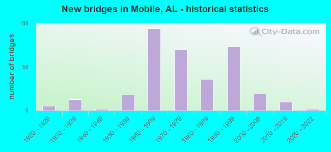
- New bridges - historical statistics
- 51920-1929
- 131930-1939
- 21940-1949
- 181950-1959
- 941960-1969
- 701970-1979
- 361980-1989
- 731990-1999
- 192000-2009
- 102010-2019
- 22020-2022
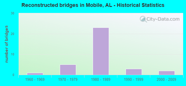
- Reconstructed bridges - Historical Statistics
- 11960-1969
- 51970-1979
- 231980-1989
- 31990-1999
- 22000-2009
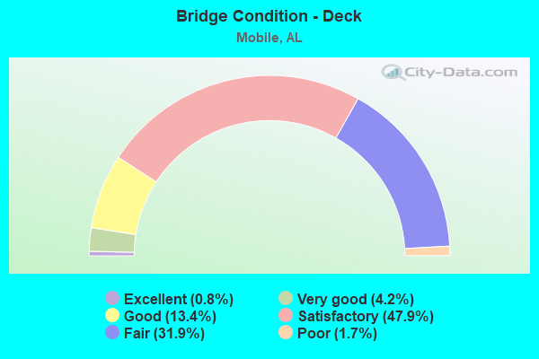
- Bridge Condition - Deck
- 0.8%Excellent
- 4.2%Very good
- 13.4%Good
- 47.9%Satisfactory
- 31.9%Fair
- 1.7%Poor
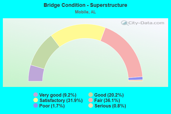
- Bridge Condition - Superstructure
- 9.2%Very good
- 20.2%Good
- 31.9%Satisfactory
- 36.1%Fair
- 1.7%Poor
- 0.8%Serious

- Bridge Condition - Substructure
- 5.0%Very good
- 23.5%Good
- 34.5%Satisfactory
- 32.8%Fair
- 2.5%Poor
- 1.7%Serious
- 0.8%Critical
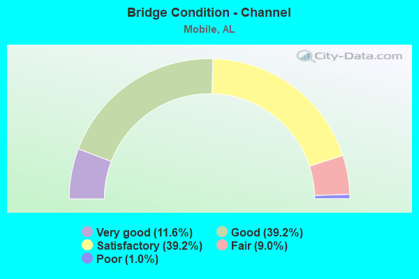
- Bridge Condition - Channel
- 11.6%Very good
- 39.2%Good
- 39.2%Satisfactory
- 9.0%Fair
- 1.0%Poor
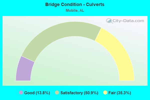
- Bridge Condition - Culverts
- 13.8%Good
- 50.9%Satisfactory
- 35.3%Fair
Find on map >> Show street view
Structure Number: 138, Location: DADEVILLE (Lat: 32.840000, Lng: -85.770000), Route carried "on" structure: City street , Year Built: 1920, Status: Posted for load, Structure Length: 1.22m (4.00ft), Average Daily Traffic: 175 (year 2021), Average Future Daily Traffic: 250 (year 2041), Design Load: H 10, Features Intersected: BRANCH, Facility Carried by Structure: DADE STREET
Minimum Vertical Clearance: 30+ m (98+ ft), Kilometerpoint: 0.100, Lanes on structure: 1, Owner: City or Municipal Highway Agency, Approaching Roadway Width: 5.2m (17.1ft), Material/Design: Steel, Design/Construction: Stringer/Multi-beam, Number Of Spans In Main Unit: 1, Length of Maximum Span: 12.2m (40.0ft), Curb-To-Curb Width: 5.2m (17.1ft), Out-to-Out Width: 5.2m (17.1ft)
Condition: Deck: Poor, Superstructure: Serious, Substructure: Poor, Channel: Poor, Operating Rating: 2.7 metric tons, Method Used To Determine Operating Rating: Allowable Stress (AS), Inventory Rating: 1.8 metric tons, Method Used To Determine Inventory Rating: Allowable Stress (AS), Structural Evaluation: High priority of replacement, Deck Geometry: High priority of replacement, Waterway Adequacy: Meets minimum limits, Approach Roadway Alignment: Equal to present desirable criteria, Bridge Posting: Required (Relationship of Operating Rating to Maximum Legal Load: > 39.9% below), Length Of Structure Improvement: 1.89m (6.20ft), Designated Inspection Frequency: Every 24 months, Other Special Inspection Frequency: Every 3 months, Inspection Date: December 2020, Other Special Inspection Date: December 2021, Bridge Improvement Cost: $221,000, Roadway Improvement Cost: $22,000, Total Project Cost: $243,000 ( Estimate for 2022), Deck Structure Type: Concrete Cast-file-Place
Find on map >> Show street view
Structure Number: 172, Location: 3 MILES SW OF SCRAP (Lat: 33.434561, Lng: -87.245292), Route carried "on" structure: County highway 15, Year Built: 1921, Status: Posted for load, Structure Length: 1.41m (4.63ft), Average Daily Traffic: 325 (year 2019), Truck Traffic: 1%, Average Future Daily Traffic: 450 (year 2039), Features Intersected: SHOAL CREEK, Facility Carried by Structure: BETTY HILL ROAD
Minimum Vertical Clearance: 30+ m (98+ ft), Kilometerpoint: 0.010, Lanes on structure: 2, Owner: County Highway Agency, Approaching Roadway Width: 5.5m (18.0ft), Skew: 3 degrees, Material/Design: Concrete continuous, Design/Construction: Slab, Number Of Spans In Main Unit: 2, Length of Maximum Span: 6.3m (20.7ft), Curb-To-Curb Width: 6.4m (21.0ft), Out-to-Out Width: 6.9m (22.6ft)
Condition: Deck: Fair, Superstructure: Fair, Substructure: Satisfactory, Channel: Fair, Operating Rating: 13.6 metric tons, Method Used To Determine Operating Rating: Field evaluation and documented engineering judgment, Inventory Rating: 10.0 metric tons, Method Used To Determine Inventory Rating: Field evaluation and documented engineering judgment, Structural Evaluation: High priority of replacement, Deck Geometry: Meets minimum limits, Waterway Adequacy: Equal to present minimum criteria, Approach Roadway Alignment: Equal to present minimum criteria, Bridge Posting: Required (Relationship of Operating Rating to Maximum Legal Load: > 39.9% below), Length Of Structure Improvement: 2.08m (6.82ft), Designated Inspection Frequency: Every 24 months, Other Special Inspection Frequency: Every 12 months, Inspection Date: September 2021, Other Special Inspection Date: September 2021, Bridge Improvement Cost: $314,000, Roadway Improvement Cost: $31,000, Total Project Cost: $345,000 ( Estimate for 2022), Deck Structure Type: Concrete Cast-file-Place, Wearing Surface/Protective System: Wearing Surface: Bituminous
Find on map >> Show street view
Structure Number: 729, Location: 1 MI S JCT AL HWY 5 (Lat: 34.231667, Lng: -87.633333), Route carried "on" structure: County highway , Year Built: 1930, Status: Closed, Structure Length: 3.51m (11.52ft), Average Daily Traffic: 300 (year 1997), Truck Traffic: 1%, Average Future Daily Traffic: 400 (year 2021), Features Intersected: SOUTHERN RAILROAD, Facility Carried by Structure: ALABAMA AVENUE
Minimum Vertical Clearance: 30+ m (98+ ft), Kilometerpoint: 0.010, Lanes on structure: 1, Owner: County Highway Agency, Maintenance Responsibility: City or Municipal Highway Agency, Approaching Roadway Width: 5.5m (18.0ft), Material/Design: Wood or Timber, Design/Construction: Stringer/Multi-beam, Number Of Spans In Main Unit: 7, Length of Maximum Span: 6.7m (22.0ft), Curb or Sidewalk Widths: Left: 0.3m (1.0ft), Right: 0.3m (1.0ft), Curb-To-Curb Width: 4.9m (16.1ft), Out-to-Out Width: 5.3m (17.4ft)
Condition: Deck: Satisfactory, Superstructure: Fair, Substructure: Poor, Approach Roadway Alignment: High priority of corrective action, Bridge Posting: Required (Relationship of Operating Rating to Maximum Legal Load: > 39.9% below), Length Of Structure Improvement: 4.42m (14.50ft), Designated Inspection Frequency: Every 24 months, Other Special Inspection Frequency: Every 12 months, Inspection Date: July 2001, Other Special Inspection Date: January 2000, Bridge Improvement Cost: $515,000, Roadway Improvement Cost: $52,000, Total Project Cost: $567,000 ( Estimate for 2022), Deck Structure Type: Wood or Timber, Wearing Surface/Protective System: Wearing Surface: Wood or Timber
Find on map >> Show street view
Structure Number: 974, Location: 1 MI W JCT AL 69 (Lat: 33.697900, Lng: -87.434500), Route carried "on" structure: State highway 18, Year Built: 1932, Status: Open, Structure Length: 0.67m (2.20ft), Average Daily Traffic: 1,130 (year 2020), Truck Traffic: 8%, Average Future Daily Traffic: 1,379 (year 2041), Features Intersected: Horns Branch
Minimum Vertical Clearance: 30+ m (98+ ft), Kilometerpoint: 94.308, Lanes on structure: 2, Owner: State Highway Agency, Approaching Roadway Width: 8.5m (27.9ft), Material/Design: Concrete, Design/Construction: Culvert, Number Of Spans In Main Unit: 2, Length of Maximum Span: 3.0m (9.8ft)
Condition: Channel: Satisfactory, Culverts: Satisfactory, Operating Rating: 53.9 metric tons, Method Used To Determine Operating Rating: Load Factor (LF), Inventory Rating: 32.3 metric tons, Method Used To Determine Inventory Rating: Load Factor (LF), Structural Evaluation: Equal to present minimum criteria, Waterway Adequacy: Equal to present minimum criteria, Approach Roadway Alignment: Somewhat better than minimum adequacy, Length Of Structure Improvement: 1.30m (4.27ft), Designated Inspection Frequency: Every 24 months, Inspection Date: January 2021, Bridge Improvement Cost: $278,000, Roadway Improvement Cost: $28,000, Total Project Cost: $306,000 ( Estimate for 2022)
Find on map >> Show street view
Structure Number: 1162, Location: 1.0 MILES S OF CROSSTON (Lat: 33.715369, Lng: -86.738139), Route carried "on" structure: County highway , Year Built: 1935, Status: Open, Structure Length: 1.29m (4.23ft), Average Daily Traffic: 15 (year 2020), Average Future Daily Traffic: 21 (year 2040), Design Load: H 15, Features Intersected: NORTH CREEK, Facility Carried by Structure: COMERS DAIRY ROAD
Minimum Vertical Clearance: 30+ m (98+ ft), Kilometerpoint: 0.010, Lanes on structure: 2, Owner: County Highway Agency, Approaching Roadway Width: 4.9m (16.1ft), Skew: 3 degrees, Material/Design: Steel, Design/Construction: Culvert, Number Of Spans In Main Unit: 3, Length of Maximum Span: 4.0m (13.1ft), Curb-To-Curb Width: 9.9m (32.5ft), Out-to-Out Width: 10.9m (35.8ft)
Condition: Channel: Satisfactory, Culverts: Satisfactory, Operating Rating: 59.1 metric tons, Method Used To Determine Operating Rating: Load Factor (LF), Inventory Rating: 53.5 metric tons, Method Used To Determine Inventory Rating: Load Factor (LF), Structural Evaluation: Equal to present minimum criteria, Deck Geometry: Superior to present desirable criteria, Waterway Adequacy: Better than present minimum criteria, Approach Roadway Alignment: Better than present minimum criteria, Length Of Structure Improvement: 1.96m (6.43ft), Designated Inspection Frequency: Every 24 months, Inspection Date: April 2020, Bridge Improvement Cost: $431,000, Roadway Improvement Cost: $43,000, Total Project Cost: $474,000 ( Estimate for 2022)
Find on map >> Show street view
Structure Number: 1182, Location: 1.9 S WEAVER (Lat: 33.729389, Lng: -85.815578), Route carried "on" structure: City street , Year Built: 1935, Status: Open, Structure Length: 0.72m (2.36ft), Average Daily Traffic: 3,600 (year 2021), Truck Traffic: 8%, Average Future Daily Traffic: 4,500 (year 2041), Features Intersected: CANE CREEK, Facility Carried by Structure: WEAVER ROAD
Minimum Vertical Clearance: 30+ m (98+ ft), Kilometerpoint: 1.899, Lanes on structure: 2, Owner: City or Municipal Highway Agency, Approaching Roadway Width: 9.3m (30.5ft), Skew: 3 degrees, Material/Design: Concrete, Design/Construction: Culvert, Number Of Spans In Main Unit: 3, Length of Maximum Span: 2.3m (7.5ft), Curb-To-Curb Width: 9.3m (30.5ft), Out-to-Out Width: 9.9m (32.5ft)
Condition: Channel: Fair, Culverts: Fair, Operating Rating: 32.7 metric tons, Method Used To Determine Operating Rating: Field evaluation and documented engineering judgment, Inventory Rating: 23.6 metric tons, Method Used To Determine Inventory Rating: Field evaluation and documented engineering judgment, Structural Evaluation: Somewhat better than minimum adequacy, Deck Geometry: Meets minimum limits, Waterway Adequacy: Equal to present minimum criteria, Approach Roadway Alignment: Somewhat better than minimum adequacy, Length Of Structure Improvement: 1.37m (4.49ft), Designated Inspection Frequency: Every 24 months, Inspection Date: Febuary 2021, Bridge Improvement Cost: $260,000, Roadway Improvement Cost: $26,000, Total Project Cost: $286,000 ( Estimate for 2022)
Find on map >> Show street view
Structure Number: 1183, Location: 1.8 MI N MT NEBO CHSR 65 (Lat: 34.815044, Lng: -86.271353), Route carried "on" structure: County highway 4, Year Built: 1935, Status: Open, Structure Length: 1.22m (4.00ft), Average Daily Traffic: 38 (year 1989), Average Future Daily Traffic: 58 (year 2040), Design Load: H 15, Features Intersected: WILLIAMS CREEK
Minimum Vertical Clearance: 30+ m (98+ ft), Kilometerpoint: 0.010, Lanes on structure: 2, Owner: County Highway Agency, Approaching Roadway Width: 7.3m (24.0ft), Material/Design: Concrete, Design/Construction: Slab, Number Of Spans In Main Unit: 3, Length of Maximum Span: 4.3m (14.1ft), Curb or Sidewalk Widths: Left: 0.3m (1.0ft), Right: 0.3m (1.0ft), Curb-To-Curb Width: 7.3m (24.0ft), Out-to-Out Width: 7.9m (25.9ft)
Condition: Deck: Fair, Superstructure: Fair, Substructure: Fair, Channel: Fair, Operating Rating: 43.5 metric tons, Method Used To Determine Operating Rating: Field evaluation and documented engineering judgment, Inventory Rating: 32.7 metric tons, Method Used To Determine Inventory Rating: Field evaluation and documented engineering judgment, Structural Evaluation: Somewhat better than minimum adequacy, Deck Geometry: Equal to present minimum criteria, Waterway Adequacy: Equal to present minimum criteria, Approach Roadway Alignment: Equal to present minimum criteria, Length Of Structure Improvement: 1.89m (6.20ft), Designated Inspection Frequency: Every 24 months, Inspection Date: Febuary 2022, Bridge Improvement Cost: $324,000, Roadway Improvement Cost: $32,000, Total Project Cost: $356,000 ( Estimate for 2022), Deck Structure Type: Concrete Cast-file-Place
Find on map >> Show street view
Structure Number: 1301, Location: 0.4 MILES SOUTH OF US 82 (Lat: 33.268333, Lng: -87.916667), Route carried "on" structure: County highway 96, Year Built: 1935, Status: Closed, Structure Length: 3.44m (11.29ft), Average Daily Traffic: 25 (year 1998), Average Future Daily Traffic: 25 (year 2032), Features Intersected: SOUTHRAIL RAILROAD
Minimum Vertical Clearance: 30+ m (98+ ft), Kilometerpoint: 0.000, Lanes on structure: 1, Owner: Railroad, Approaching Roadway Width: 7.3m (24.0ft), Material/Design: Wood or Timber, Design/Construction: Stringer/Multi-beam, Number Of Spans In Main Unit: 5, Length of Maximum Span: 7.0m (23.0ft), Curb-To-Curb Width: 4.6m (15.1ft), Out-to-Out Width: 4.9m (16.1ft)
Condition: Deck: Poor, Superstructure: Satisfactory, Substructure: Critical, Deck Geometry: Better than present minimum criteria, Underclear: Meets minimum limits, Approach Roadway Alignment: High priority of corrective action, Bridge Posting: Required (Relationship of Operating Rating to Maximum Legal Load: > 39.9% below), Length Of Structure Improvement: 4.34m (14.24ft), Designated Inspection Frequency: Every 24 months, Other Special Inspection Frequency: Every 12 months, Inspection Date: March 2014, Other Special Inspection Date: March 2014, Bridge Improvement Cost: $476,000, Roadway Improvement Cost: $48,000, Total Project Cost: $524,000 ( Estimate for 2022), Deck Structure Type: Wood or Timber, Wearing Surface/Protective System: Wearing Surface: Wood or Timber
Find on map >> Show street view
Structure Number: 1303, Location: 0.1 MI N FAIRWAY DR (Lat: 30.663664, Lng: -88.092869), Route carried "on" structure: City street , Year Built: 1935, Status: Open, Structure Length: 4.02m (13.19ft), Average Daily Traffic: 5,869 (year 2022), Truck Traffic: 1%, Average Future Daily Traffic: 8,744 (year 2042), Design Load: H 15, Features Intersected: ESLAVA CREEK, Facility Carried by Structure: HOLCOMBE AVE
Minimum Vertical Clearance: 30+ m (98+ ft), Kilometerpoint: 0.100, Lanes on structure: 4, Owner: City or Municipal Highway Agency, Approaching Roadway Width: 12.2m (40.0ft), Skew: 4 degrees, Material/Design: Concrete, Design/Construction: Tee Beam, Number Of Spans In Main Unit: 5, Length of Maximum Span: 7.1m (23.3ft), Curb or Sidewalk Widths: Left: 1.4m (4.6ft), Right: 1.4m (4.6ft), Curb-To-Curb Width: 12.1m (39.7ft), Out-to-Out Width: 15.6m (51.2ft)
Condition: Deck: Satisfactory, Superstructure: Fair, Substructure: Satisfactory, Channel: Satisfactory, Operating Rating: 57.4 metric tons, Method Used To Determine Operating Rating: Load Factor (LF), Inventory Rating: 34.4 metric tons, Method Used To Determine Inventory Rating: Load Factor (LF), Structural Evaluation: Somewhat better than minimum adequacy, Deck Geometry: High priority of replacement, Waterway Adequacy: Better than present minimum criteria, Approach Roadway Alignment: Better than present minimum criteria, Length Of Structure Improvement: 4.98m (16.34ft), Designated Inspection Frequency: Every 24 months, Inspection Date: January 2022, Bridge Improvement Cost: $1,740,000, Roadway Improvement Cost: $174,000, Total Project Cost: $1,914,000 ( Estimate for 2022), Deck Structure Type: Concrete Cast-file-Place
Find on map >> Show street view
Structure Number: 1338, Location: 1.3 MI. S. SR 163 (Lat: 30.534961, Lng: -88.107078), Route carried "on" structure: County highway , Year Built: 1935, Status: Open, Structure Length: 1.36m (4.46ft), Average Daily Traffic: 127 (year 2020), Truck Traffic: 3%, Average Future Daily Traffic: 189 (year 2040), Design Load: H 20, Features Intersected: NORTH FORK DEER RIVER, Facility Carried by Structure: DAUPHIN IS.PKWY N
Minimum Vertical Clearance: 30+ m (98+ ft), Kilometerpoint: 1.291, Lanes on structure: 2, Owner: County Highway Agency, Approaching Roadway Width: 7.3m (24.0ft), Material/Design: Concrete continuous, Design/Construction: Slab, Number Of Spans In Main Unit: 3, Length of Maximum Span: 4.6m (15.1ft), Curb or Sidewalk Widths: Left: 0.2m (0.7ft), Right: 0.2m (0.7ft), Curb-To-Curb Width: 6.0m (19.7ft), Out-to-Out Width: 6.4m (21.0ft)
Condition: Deck: Fair, Superstructure: Fair, Substructure: Fair, Channel: Satisfactory, Operating Rating: 32.7 metric tons, Method Used To Determine Operating Rating: Field evaluation and documented engineering judgment, Inventory Rating: 24.5 metric tons, Method Used To Determine Inventory Rating: Field evaluation and documented engineering judgment, Structural Evaluation: Somewhat better than minimum adequacy, Deck Geometry: High priority of corrective action, Waterway Adequacy: Better than present minimum criteria, Approach Roadway Alignment: Equal to present minimum criteria, Length Of Structure Improvement: 2.04m (6.69ft), Designated Inspection Frequency: Every 24 months, Underwater Inspection Frequency: Every 24 months, Inspection Date: May 2020, Underwater Inspection Date: May 2020, Bridge Improvement Cost: $293,000, Roadway Improvement Cost: $29,000, Total Project Cost: $322,000 ( Estimate for 2022), Deck Structure Type: Concrete Cast-file-Place, Wearing Surface/Protective System: Wearing Surface: Bituminous
Find on map >> Show street view
Structure Number: 1381, Location: BOBBY JOHNSON)S GRAHAM (Lat: 33.429100, Lng: -85.309500), Route carried "on" structure: County highway , Year Built: 1936, Status: Posted for load, Structure Length: 1.16m (3.81ft), Average Daily Traffic: 60 (year 1990), Average Future Daily Traffic: 84 (year 2034), Design Load: H 10, Features Intersected: SHOAL CREEK, Facility Carried by Structure: CO RD 438
Minimum Vertical Clearance: 30+ m (98+ ft), Kilometerpoint: 0.010, Lanes on structure: 1, Owner: County Highway Agency, Approaching Roadway Width: 4.9m (16.1ft), Material/Design: Steel, Design/Construction: Stringer/Multi-beam, Number Of Spans In Main Unit: 1, Length of Maximum Span: 11.6m (38.1ft), Curb-To-Curb Width: 3.4m (11.2ft), Out-to-Out Width: 3.4m (11.2ft)
Condition: Deck: Fair, Superstructure: Fair, Substructure: Fair, Channel: Satisfactory, Operating Rating: 34.1 metric tons, Method Used To Determine Operating Rating: Load Factor (LF), Inventory Rating: 21.3 metric tons, Method Used To Determine Inventory Rating: Load Factor (LF), Structural Evaluation: Somewhat better than minimum adequacy, Deck Geometry: High priority of corrective action, Waterway Adequacy: Somewhat better than minimum adequacy, Approach Roadway Alignment: Equal to present minimum criteria, Bridge Posting: Required (Relationship of Operating Rating to Maximum Legal Load: 10.0 - 19.9% below), Length Of Structure Improvement: 1.84m (6.04ft), Designated Inspection Frequency: Every 24 months, Other Special Inspection Frequency: Every 3 months, Inspection Date: August 2021, Other Special Inspection Date: Febuary 2022, Bridge Improvement Cost: $139,000, Roadway Improvement Cost: $14,000, Total Project Cost: $153,000 ( Estimate for 2019), Deck Structure Type: Wood or Timber, Wearing Surface/Protective System: Wearing Surface: Wood or Timber
Find on map >> Show street view
Structure Number: 1543, Location: 0.4 MI N CO 8 (Lat: 34.955833, Lng: -87.824781), Route carried "on" structure: County highway 5, Year Built: 1937, Status: Posted for load, Structure Length: 0.91m (2.99ft), Average Daily Traffic: 270 (year 2001), Truck Traffic: 10%, Average Future Daily Traffic: 244 (year 2031), Features Intersected: THREET CREEK
Minimum Vertical Clearance: 30+ m (98+ ft), Kilometerpoint: 0.010, Lanes on structure: 2, Owner: County Highway Agency, Approaching Roadway Width: 7.9m (25.9ft), Material/Design: Concrete, Design/Construction: Tee Beam, Number Of Spans In Main Unit: 1, Length of Maximum Span: 9.1m (29.9ft), Curb or Sidewalk Widths: Left: 0.5m (1.6ft), Right: 0.5m (1.6ft), Curb-To-Curb Width: 6.1m (20.0ft), Out-to-Out Width: 7.0m (23.0ft)
Condition: Deck: Fair, Superstructure: Fair, Substructure: Fair, Channel: Satisfactory, Operating Rating: 13.6 metric tons, Method Used To Determine Operating Rating: Field evaluation and documented engineering judgment, Inventory Rating: 12.7 metric tons, Method Used To Determine Inventory Rating: Field evaluation and documented engineering judgment, Structural Evaluation: Meets minimum limits, Waterway Adequacy: Better than present minimum criteria, Approach Roadway Alignment: Better than present minimum criteria, Bridge Posting: Required (Relationship of Operating Rating to Maximum Legal Load: > 39.9% below), Length Of Structure Improvement: 1.58m (5.18ft), Designated Inspection Frequency: Every 24 months, Other Special Inspection Frequency: Every 12 months, Inspection Date: October 2020, Other Special Inspection Date: October 2021, Bridge Improvement Cost: $249,000, Roadway Improvement Cost: $25,000, Total Project Cost: $274,000 ( Estimate for 2022), Deck Structure Type: Concrete Cast-file-Place, Wearing Surface/Protective System: Wearing Surface: Bituminous
Find on map >> Show street view
Structure Number: 177, Location: 1MI S CO RT 50 T7SR6E (Lat: 34.453478, Lng: -86.013297), Route carried "on" structure: County highway 27, Year Built: 1938, Status: Posted for load, Structure Length: 0.91m (2.99ft), Average Daily Traffic: 95 (year 2021), Average Future Daily Traffic: 141 (year 2041), Design Load: H 10, Features Intersected: BLACK OAK CREEK, Facility Carried by Structure: CO RD 536
Minimum Vertical Clearance: 30+ m (98+ ft), Kilometerpoint: 0.010, Lanes on structure: 1, Owner: County Highway Agency, Approaching Roadway Width: 3.4m (11.2ft), Material/Design: Steel, Design/Construction: Stringer/Multi-beam, Number Of Spans In Main Unit: 1, Length of Maximum Span: 9.1m (29.9ft), Curb-To-Curb Width: 3.4m (11.2ft), Out-to-Out Width: 3.4m (11.2ft)
Condition: Deck: Satisfactory, Superstructure: Fair, Substructure: Serious, Channel: Satisfactory, Operating Rating: 2.7 metric tons, Method Used To Determine Operating Rating: Allowable Stress (AS), Inventory Rating: 1.8 metric tons, Method Used To Determine Inventory Rating: Allowable Stress (AS), Structural Evaluation: High priority of replacement, Deck Geometry: High priority of corrective action, Waterway Adequacy: Meets minimum limits, Approach Roadway Alignment: Equal to present minimum criteria, Bridge Posting: Required (Relationship of Operating Rating to Maximum Legal Load: > 39.9% below), Length Of Structure Improvement: 1.59m (5.22ft), Designated Inspection Frequency: Every 24 months, Other Special Inspection Frequency: Every 3 months, Inspection Date: October 2021, Other Special Inspection Date: January 2022, Bridge Improvement Cost: $120,000, Roadway Improvement Cost: $12,000, Total Project Cost: $132,000 ( Estimate for 2022), Deck Structure Type: Concrete Cast-file-Place
Find on map >> Show street view
Structure Number: 2731, Location: 1.6 MI N CLAIRBORNE ST (Lat: 30.703642, Lng: -88.071800), Route carried "on" structure: City street , Year Built: 1992, Status: Open, Structure Length: 7.07m (23.20ft), Average Daily Traffic: 6,594 (year 2022), Truck Traffic: 1%, Average Future Daily Traffic: 9,825 (year 2042), Design Load: HS 20, Features Intersected: THREE MILE CREEK, Facility Carried by Structure: M. L. KING JR AVE
Minimum Vertical Clearance: 30+ m (98+ ft), Kilometerpoint: 1.600, Lanes on structure: 4, Owner: City or Municipal Highway Agency, Approaching Roadway Width: 12.4m (40.7ft), Material/Design: Prestressed concrete, Design/Construction: Stringer/Multi-beam, Number Of Spans In Main Unit: 5, Length of Maximum Span: 15.2m (49.9ft), Curb or Sidewalk Widths: Left: 1.5m (4.9ft), Right: 1.5m (4.9ft), Curb-To-Curb Width: 12.4m (40.7ft), Out-to-Out Width: 16.3m (53.5ft)
Condition: Deck: Satisfactory, Superstructure: Satisfactory, Substructure: Satisfactory, Channel: Good, Operating Rating: 54.6 metric tons, Method Used To Determine Operating Rating: Load Factor (LF), Inventory Rating: 34.0 metric tons, Method Used To Determine Inventory Rating: Load Factor (LF), Structural Evaluation: Equal to present minimum criteria, Deck Geometry: High priority of replacement, Waterway Adequacy: Equal to present desirable criteria, Approach Roadway Alignment: Equal to present desirable criteria, Length Of Structure Improvement: 8.10m (26.57ft), Designated Inspection Frequency: Every 24 months, Underwater Inspection Frequency: Every 24 months, Inspection Date: Febuary 2022, Underwater Inspection Date: Febuary 2022, Bridge Improvement Cost: $2,945,000, Roadway Improvement Cost: $295,000, Total Project Cost: $3,240,000 ( Estimate for 2022), Deck Structure Type: Concrete Cast-file-Place
Find on map >> Show street view
Structure Number: 3083, Location: 0.3 MI E NAVCO RD (Lat: 30.643661, Lng: -88.096900), Route carried "on" structure: City street , Year Built: 1947, Status: Open, Structure Length: 3.72m (12.20ft), Average Daily Traffic: 13,249 (year 2022), Truck Traffic: 4%, Average Future Daily Traffic: 19,740 (year 2042), Design Load: H 15, Features Intersected: ESLAVA CREEK, Facility Carried by Structure: MC VAY DR
Minimum Vertical Clearance: 30+ m (98+ ft), Kilometerpoint: 1.600, Lanes on structure: 2, Owner: City or Municipal Highway Agency, Approaching Roadway Width: 6.4m (21.0ft), Material/Design: Concrete continuous, Design/Construction: Tee Beam, Number Of Spans In Main Unit: 3, Length of Maximum Span: 12.5m (41.0ft), Curb or Sidewalk Widths: Left: 1.1m (3.6ft), Right: 1.1m (3.6ft), Curb-To-Curb Width: 8.0m (26.2ft), Out-to-Out Width: 11.0m (36.1ft)
Condition: Deck: Fair, Superstructure: Fair, Substructure: Fair, Channel: Satisfactory, Operating Rating: 39.9 metric tons, Method Used To Determine Operating Rating: Load Factor (LF), Inventory Rating: 23.9 metric tons, Method Used To Determine Inventory Rating: Load Factor (LF), Structural Evaluation: Somewhat better than minimum adequacy, Deck Geometry: High priority of replacement, Waterway Adequacy: Better than present minimum criteria, Approach Roadway Alignment: Equal to present minimum criteria, Length Of Structure Improvement: 4.65m (15.26ft), Designated Inspection Frequency: Every 24 months, Underwater Inspection Frequency: Every 48 months, Inspection Date: January 2022, Underwater Inspection Date: November 2019, Bridge Improvement Cost: $1,147,000, Roadway Improvement Cost: $115,000, Total Project Cost: $1,262,000 ( Estimate for 2022), Deck Structure Type: Concrete Cast-file-Place, Wearing Surface/Protective System: Wearing Surface: Bituminous
Find on map >> Show street view
Structure Number: 3691, Location: 1.3 MI E SR 193 (Lat: 30.608397, Lng: -88.162386), Route carried "on" structure: US 90, Year Built: 1950, Status: Open, Structure Length: 5.18m (16.99ft), Average Daily Traffic: 24,385 (year 2019), Truck Traffic: 2%, Average Future Daily Traffic: 36,578 (year 2039), Design Load: HS 20, Features Intersected: HALLS MILL CREEK
Minimum Vertical Clearance: 30+ m (98+ ft), Kilometerpoint: 31.033, Lanes on structure: 4, Owner: State Highway Agency, Approaching Roadway Width: 17.1m (56.1ft), Skew: 30 degrees, Material/Design: Concrete, Design/Construction: Tee Beam, Number Of Spans In Main Unit: 5, Length of Maximum Span: 10.4m (34.1ft), Curb-To-Curb Width: 16.9m (55.4ft), Out-to-Out Width: 18.7m (61.4ft)
Condition: Deck: Fair, Superstructure: Fair, Substructure: Fair, Channel: Satisfactory, Operating Rating: 49.6 metric tons, Method Used To Determine Operating Rating: Load Factor (LF), Inventory Rating: 29.8 metric tons, Method Used To Determine Inventory Rating: Load Factor (LF), Structural Evaluation: Somewhat better than minimum adequacy, Deck Geometry: Somewhat better than minimum adequacy, Waterway Adequacy: Equal to present minimum criteria, Approach Roadway Alignment: Better than present minimum criteria, Length Of Structure Improvement: 6.21m (20.37ft), Designated Inspection Frequency: Every 24 months, Inspection Date: July 2020, Bridge Improvement Cost: $2,596,000, Roadway Improvement Cost: $260,000, Total Project Cost: $2,856,000 ( Estimate for 2022), Deck Structure Type: Concrete Cast-file-Place
Find on map >> Show street view
Structure Number: 3692, Location: 2.1 MI E SR 193 (Lat: 30.617567, Lng: -88.157878), Route carried "on" structure: US 90, Year Built: 1950, Status: Open, Structure Length: 1.01m (3.31ft), Average Daily Traffic: 24,385 (year 2019), Truck Traffic: 2%, Average Future Daily Traffic: 36,578 (year 2039), Design Load: HS 20, Features Intersected: SPRING BRANCH
Minimum Vertical Clearance: 30+ m (98+ ft), Kilometerpoint: 32.129, Lanes on structure: 5, Owner: State Highway Agency, Approaching Roadway Width: 18.9m (62.0ft), Skew: 20 degrees, Material/Design: Concrete, Design/Construction: Culvert, Number Of Spans In Main Unit: 3, Length of Maximum Span: 3.0m (9.8ft)
Condition: Channel: Fair, Culverts: Fair, Operating Rating: 50.4 metric tons, Method Used To Determine Operating Rating: Load Factor (LF), Inventory Rating: 30.3 metric tons, Method Used To Determine Inventory Rating: Load Factor (LF), Structural Evaluation: Somewhat better than minimum adequacy, Waterway Adequacy: Equal to present minimum criteria, Approach Roadway Alignment: Better than present minimum criteria, Length Of Structure Improvement: 1.68m (5.51ft), Designated Inspection Frequency: Every 24 months, Other Special Inspection Frequency: Every 12 months, Inspection Date: July 2020, Other Special Inspection Date: July 2021, Bridge Improvement Cost: $1,190,000, Roadway Improvement Cost: $119,000, Total Project Cost: $1,309,000 ( Estimate for 2022)
Find on map >> Show street view
Structure Number: 3843, Location: 0.3 MI W CATHERINE ST (Lat: 30.696242, Lng: -88.077650), Route carried "on" structure: City street , Year Built: 1950, Status: Posted for load, Structure Length: 0.91m (2.99ft), Average Daily Traffic: 8,264 (year 2022), Truck Traffic: 1%, Average Future Daily Traffic: 12,313 (year 2042), Design Load: H 15, Features Intersected: BRANCH, Facility Carried by Structure: CENTER STREET
Minimum Vertical Clearance: 30+ m (98+ ft), Kilometerpoint: 0.100, Lanes on structure: 2, Owner: City or Municipal Highway Agency, Approaching Roadway Width: 7.8m (25.6ft), Material/Design: Concrete, Design/Construction: Tee Beam, Number Of Spans In Main Unit: 1, Length of Maximum Span: 9.1m (29.9ft), Curb or Sidewalk Widths: Left: 1.5m (4.9ft), Right: 1.5m (4.9ft), Curb-To-Curb Width: 7.8m (25.6ft), Out-to-Out Width: 11.5m (37.7ft)
Condition: Deck: Fair, Superstructure: Satisfactory, Substructure: Satisfactory, Channel: Satisfactory, Operating Rating: 25.9 metric tons, Method Used To Determine Operating Rating: Load Factor (LF), Inventory Rating: 15.5 metric tons, Method Used To Determine Inventory Rating: Load Factor (LF), Structural Evaluation: High priority of replacement, Deck Geometry: High priority of replacement, Waterway Adequacy: Equal to present desirable criteria, Approach Roadway Alignment: Better than present minimum criteria, Bridge Posting: Required (Relationship of Operating Rating to Maximum Legal Load: 30.0 - 39.9% below), Length Of Structure Improvement: 1.58m (5.18ft), Designated Inspection Frequency: Every 24 months, Other Special Inspection Frequency: Every 12 months, Inspection Date: January 2022, Other Special Inspection Date: January 2022, Bridge Improvement Cost: $401,000, Roadway Improvement Cost: $40,000, Total Project Cost: $441,000 ( Estimate for 2022), Deck Structure Type: Concrete Cast-file-Place
Find on map >> Show street view
Structure Number: 4317, Location: 0.6 MI E I-65 (Lat: 30.657142, Lng: -88.113994), Route carried "on" structure: US 90, Year Built: 1952, Status: Open, Structure Length: 0.64m (2.10ft), Average Daily Traffic: 21,933 (year 2019), Truck Traffic: 2%, Average Future Daily Traffic: 32,900 (year 2039), Design Load: H 15, Features Intersected: BOLTON DITCH
Minimum Vertical Clearance: 30+ m (98+ ft), Kilometerpoint: 38.278, Lanes on structure: 5, Owner: State Highway Agency, Approaching Roadway Width: 18.6m (61.0ft), Skew: 23 degrees, Material/Design: Concrete, Design/Construction: Culvert, Number Of Spans In Main Unit: 3, Length of Maximum Span: 3.0m (9.8ft)
Condition: Channel: Good, Culverts: Satisfactory, Operating Rating: 41.1 metric tons, Method Used To Determine Operating Rating: Load Factor (LF), Inventory Rating: 24.7 metric tons, Method Used To Determine Inventory Rating: Load Factor (LF), Structural Evaluation: Equal to present minimum criteria, Waterway Adequacy: Equal to present minimum criteria, Approach Roadway Alignment: Equal to present desirable criteria, Length Of Structure Improvement: 1.26m (4.13ft), Designated Inspection Frequency: Every 24 months, Inspection Date: July 2020, Bridge Improvement Cost: $873,000, Roadway Improvement Cost: $87,000, Total Project Cost: $960,000 ( Estimate for 2022)
Find on map >> Show street view
Structure Number: 4318, Location: 0.6 MI E I-65 (Lat: 30.657342, Lng: -88.113664), Route carried "on" structure: US 90, Year Built: 1952, Status: Open, Structure Length: 0.91m (2.99ft), Average Daily Traffic: 21,933 (year 2019), Truck Traffic: 2%, Average Future Daily Traffic: 32,900 (year 2039), Design Load: H 15, Features Intersected: BOLTON BRANCH
Minimum Vertical Clearance: 30+ m (98+ ft), Kilometerpoint: 38.318, Lanes on structure: 5, Owner: State Highway Agency, Approaching Roadway Width: 18.6m (61.0ft), Skew: 23 degrees, Material/Design: Concrete, Design/Construction: Culvert, Number Of Spans In Main Unit: 2, Length of Maximum Span: 2.4m (7.9ft)
Condition: Channel: Good, Culverts: Satisfactory, Operating Rating: 58.1 metric tons, Method Used To Determine Operating Rating: Load Factor (LF), Inventory Rating: 34.7 metric tons, Method Used To Determine Inventory Rating: Load Factor (LF), Structural Evaluation: Equal to present minimum criteria, Waterway Adequacy: Equal to present minimum criteria, Approach Roadway Alignment: Equal to present desirable criteria, Length Of Structure Improvement: 1.59m (5.22ft), Designated Inspection Frequency: Every 24 months, Inspection Date: July 2020, Bridge Improvement Cost: $1,154,000, Roadway Improvement Cost: $115,000, Total Project Cost: $1,269,000 ( Estimate for 2022)
Find on map >> Show street view
Structure Number: 4319, Location: 2.0 MI E I-65 (Lat: 30.670967, Lng: -88.101583), Route carried "on" structure: US 90, Year Built: 1952, Status: Open, Structure Length: 2.68m (8.79ft), Average Daily Traffic: 17,357 (year 2019), Truck Traffic: 2%, Average Future Daily Traffic: 26,035 (year 2039), Design Load: HS 20, Features Intersected: ESLAVA CREEK
Minimum Vertical Clearance: 30+ m (98+ ft), Kilometerpoint: 40.258, Lanes on structure: 6, Owner: State Highway Agency, Approaching Roadway Width: 21.9m (71.9ft), Skew: 24 degrees, Material/Design: Concrete, Design/Construction: Culvert, Number Of Spans In Main Unit: 5, Length of Maximum Span: 3.7m (12.1ft)
Condition: Channel: Satisfactory, Culverts: Fair, Operating Rating: 41.2 metric tons, Method Used To Determine Operating Rating: Load Factor (LF), Inventory Rating: 24.7 metric tons, Method Used To Determine Inventory Rating: Load Factor (LF), Structural Evaluation: Somewhat better than minimum adequacy, Waterway Adequacy: Equal to present minimum criteria, Approach Roadway Alignment: Equal to present desirable criteria, Length Of Structure Improvement: 3.60m (11.81ft), Designated Inspection Frequency: Every 24 months, Inspection Date: July 2020, Bridge Improvement Cost: $2,575,000, Roadway Improvement Cost: $258,000, Total Project Cost: $2,833,000 ( Estimate for 2022)
Find on map >> Show street view
Structure Number: 4437, Location: 350' E BAY SHORE AVE (Lat: 30.703306, Lng: -88.105100), Route carried "on" structure: City street , Year Built: 1952, Status: Open, Structure Length: 0.64m (2.10ft), Average Daily Traffic: 2,162 (year 2022), Truck Traffic: 1%, Average Future Daily Traffic: 3,222 (year 2042), Design Load: H 15, Features Intersected: BRANCH, Facility Carried by Structure: NALL STREET
Minimum Vertical Clearance: 30+ m (98+ ft), Kilometerpoint: 0.100, Lanes on structure: 2, Owner: City or Municipal Highway Agency, Approaching Roadway Width: 7.9m (25.9ft), Skew: 4 degrees, Material/Design: Concrete, Design/Construction: Culvert, Number Of Spans In Main Unit: 1, Length of Maximum Span: 4.3m (14.1ft), Curb or Sidewalk Widths: Left: 0.2m (0.7ft), Right: 0.2m (0.7ft), Curb-To-Curb Width: 7.9m (25.9ft), Out-to-Out Width: 14.6m (47.9ft)
Condition: Channel: Satisfactory, Culverts: Good, Operating Rating: 43.5 metric tons, Method Used To Determine Operating Rating: Field evaluation and documented engineering judgment, Inventory Rating: 32.7 metric tons, Method Used To Determine Inventory Rating: Field evaluation and documented engineering judgment, Structural Evaluation: Better than present minimum criteria, Deck Geometry: High priority of corrective action, Waterway Adequacy: Equal to present minimum criteria, Approach Roadway Alignment: Better than present minimum criteria, Length Of Structure Improvement: 1.26m (4.13ft), Designated Inspection Frequency: Every 24 months, Inspection Date: January 2022, Bridge Improvement Cost: $546,000, Roadway Improvement Cost: $55,000, Total Project Cost: $601,000 ( Estimate for 2022)
Find on map >> Show street view
Structure Number: 551, Location: 150' N E FOREST AVE (Lat: 30.725831, Lng: -88.092425), Route carried "on" structure: City street , Year Built: 1956, Status: Posted for load, Structure Length: 0.91m (2.99ft), Average Daily Traffic: 168 (year 2022), Truck Traffic: 5%, Average Future Daily Traffic: 251 (year 2042), Design Load: H 15, Features Intersected: TOULMIN SPRINGS, Facility Carried by Structure: GRAHAM AVE
Minimum Vertical Clearance: 30+ m (98+ ft), Kilometerpoint: 0.100, Lanes on structure: 2, Owner: City or Municipal Highway Agency, Approaching Roadway Width: 8.1m (26.6ft), Skew: 1 degrees, Material/Design: Concrete, Design/Construction: Tee Beam, Number Of Spans In Main Unit: 1, Length of Maximum Span: 9.1m (29.9ft), Curb or Sidewalk Widths: Left: 1.5m (4.9ft), Right: 1.5m (4.9ft), Curb-To-Curb Width: 8.1m (26.6ft), Out-to-Out Width: 10.6m (34.8ft)
Condition: Deck: Satisfactory, Superstructure: Good, Substructure: Satisfactory, Channel: Very good, Operating Rating: 27.7 metric tons, Method Used To Determine Operating Rating: Load Factor (LF), Inventory Rating: 16.5 metric tons, Method Used To Determine Inventory Rating: Load Factor (LF), Structural Evaluation: Somewhat better than minimum adequacy, Deck Geometry: Somewhat better than minimum adequacy, Waterway Adequacy: Equal to present desirable criteria, Approach Roadway Alignment: Better than present minimum criteria, Bridge Posting: Required (Relationship of Operating Rating to Maximum Legal Load: 30.0 - 39.9% below), Length Of Structure Improvement: 1.58m (5.18ft), Designated Inspection Frequency: Every 24 months, Other Special Inspection Frequency: Every 12 months, Inspection Date: January 2022, Other Special Inspection Date: January 2022, Bridge Improvement Cost: $368,000, Roadway Improvement Cost: $37,000, Total Project Cost: $405,000 ( Estimate for 2022), Deck Structure Type: Concrete Cast-file-Place
Find on map >> Show street view
Structure Number: 6005, Location: MORGAN @ LAWRENCE (Lat: 30.702139, Lng: -88.054175), Route carried "on" structure: City street , Year Built: 1957, Status: Posted for load, Structure Length: 0.91m (2.99ft), Average Daily Traffic: 1,441 (year 2022), Truck Traffic: 5%, Average Future Daily Traffic: 2,148 (year 2042), Design Load: H 15, Features Intersected: ONE MILE CREEK, Facility Carried by Structure: MORGAN STREET
Minimum Vertical Clearance: 30+ m (98+ ft), Kilometerpoint: 0.100, Lanes on structure: 2, Owner: City or Municipal Highway Agency, Approaching Roadway Width: 7.9m (25.9ft), Material/Design: Concrete, Design/Construction: Tee Beam, Number Of Spans In Main Unit: 1, Length of Maximum Span: 9.1m (29.9ft), Curb or Sidewalk Widths: Left: 1.5m (4.9ft), Right: 1.5m (4.9ft), Curb-To-Curb Width: 7.9m (25.9ft), Out-to-Out Width: 11.5m (37.7ft)
Condition: Deck: Fair, Superstructure: Good, Substructure: Fair, Channel: Satisfactory, Operating Rating: 28.3 metric tons, Method Used To Determine Operating Rating: Load Factor (LF), Inventory Rating: 17.0 metric tons, Method Used To Determine Inventory Rating: Load Factor (LF), Structural Evaluation: Meets minimum limits, Deck Geometry: Meets minimum limits, Waterway Adequacy: Equal to present desirable criteria, Approach Roadway Alignment: Meets minimum limits, Bridge Posting: Required (Relationship of Operating Rating to Maximum Legal Load: 20.0 - 29.9% below), Length Of Structure Improvement: 1.58m (5.18ft), Designated Inspection Frequency: Every 24 months, Other Special Inspection Frequency: Every 12 months, Inspection Date: January 2022, Other Special Inspection Date: January 2022, Bridge Improvement Cost: $401,000, Roadway Improvement Cost: $40,000, Total Project Cost: $441,000 ( Estimate for 2022), Deck Structure Type: Concrete Cast-file-Place
Find on map >> Show street view
Structure Number: 6015, Location: 1800' W. INDIAN SPRING RD (Lat: 30.748964, Lng: -88.180472), Route carried "on" structure: City street , Year Built: 1957, Status: Open, Structure Length: 4.15m (13.62ft), Average Daily Traffic: 4,629 (year 2021), Truck Traffic: 4%, Average Future Daily Traffic: 6,897 (year 2041), Design Load: H 15, Features Intersected: RED CREEK, Facility Carried by Structure: BEAR FORK ROAD
Minimum Vertical Clearance: 30+ m (98+ ft), Kilometerpoint: 1.600, Lanes on structure: 2, Owner: City or Municipal Highway Agency, Approaching Roadway Width: 7.3m (24.0ft), Material/Design: Concrete, Design/Construction: Tee Beam, Number Of Spans In Main Unit: 4, Length of Maximum Span: 10.4m (34.1ft), Curb or Sidewalk Widths: Left: 0.6m (2.0ft), Right: 0.6m (2.0ft), Curb-To-Curb Width: 8.5m (27.9ft), Out-to-Out Width: 10.1m (33.1ft)
Condition: Deck: Fair, Superstructure: Good, Substructure: Fair, Channel: Fair, Operating Rating: 44.8 metric tons, Method Used To Determine Operating Rating: Load Factor (LF), Inventory Rating: 26.9 metric tons, Method Used To Determine Inventory Rating: Load Factor (LF), Structural Evaluation: Somewhat better than minimum adequacy, Deck Geometry: Meets minimum limits, Waterway Adequacy: Better than present minimum criteria, Approach Roadway Alignment: Equal to present desirable criteria, Length Of Structure Improvement: 5.12m (16.80ft), Designated Inspection Frequency: Every 24 months, Inspection Date: November 2021, Bridge Improvement Cost: $1,158,000, Roadway Improvement Cost: $116,000, Total Project Cost: $1,274,000 ( Estimate for 2022), Deck Structure Type: Concrete Cast-file-Place
Find on map >> Show street view
Structure Number: 6016, Location: 0.9 MI E.SHELTON BEACH RD (Lat: 30.748958, Lng: -88.132422), Route carried "on" structure: City street , Year Built: 1957, Status: Posted for load, Structure Length: 6.22m (20.41ft), Average Daily Traffic: 6,893 (year 2021), Truck Traffic: 4%, Average Future Daily Traffic: 10,271 (year 2041), Design Load: H 15, Features Intersected: EIGHTMILE CREEK, Facility Carried by Structure: BEAR FORK ROAD
Minimum Vertical Clearance: 30+ m (98+ ft), Kilometerpoint: 4.500, Lanes on structure: 2, Owner: City or Municipal Highway Agency, Approaching Roadway Width: 6.1m (20.0ft), Material/Design: Concrete, Design/Construction: Tee Beam, Number Of Spans In Main Unit: 6, Length of Maximum Span: 10.4m (34.1ft), Curb or Sidewalk Widths: Left: 0.5m (1.6ft), Right: 0.5m (1.6ft), Curb-To-Curb Width: 7.3m (24.0ft), Out-to-Out Width: 8.4m (27.6ft)
Condition: Deck: Fair, Superstructure: Fair, Substructure: Fair, Channel: Satisfactory, Operating Rating: 33.8 metric tons, Method Used To Determine Operating Rating: Load Factor (LF), Inventory Rating: 20.2 metric tons, Method Used To Determine Inventory Rating: Load Factor (LF), Structural Evaluation: Somewhat better than minimum adequacy, Deck Geometry: High priority of replacement, Waterway Adequacy: Better than present minimum criteria, Approach Roadway Alignment: Better than present minimum criteria, Bridge Posting: Required (Relationship of Operating Rating to Maximum Legal Load: 10.0 - 19.9% below), Length Of Structure Improvement: 7.26m (23.82ft), Designated Inspection Frequency: Every 24 months, Other Special Inspection Frequency: Every 12 months, Inspection Date: November 2021, Other Special Inspection Date: November 2021, Bridge Improvement Cost: $1,344,000, Roadway Improvement Cost: $134,000, Total Project Cost: $1,478,000 ( Estimate for 2022), Deck Structure Type: Concrete Cast-file-Place
Find on map >> Show street view
Structure Number: 6579, Location: 0.5 MI W I-65 (Lat: 30.649928, Lng: -88.125961), Route carried "on" structure: US 90, Year Built: 1959, Status: Open, Structure Length: 7.25m (23.79ft), Average Daily Traffic: 20,103 (year 2018), Truck Traffic: 2%, Average Future Daily Traffic: 30,154 (year 2038), Design Load: HS 20, Features Intersected: WRAGG SWAMP CANAL
Minimum Vertical Clearance: 30+ m (98+ ft), Kilometerpoint: 36.880, Lanes on structure: 3, Owner: State Highway Agency, Approaching Roadway Width: 14.4m (47.2ft), Skew: 10 degrees, Material/Design: Concrete, Design/Construction: Tee Beam, Number Of Spans In Main Unit: 6, Length of Maximum Span: 10.4m (34.1ft), Curb-To-Curb Width: 14.4m (47.2ft), Out-to-Out Width: 15.8m (51.8ft)
Condition: Deck: Satisfactory, Superstructure: Satisfactory, Substructure: Satisfactory, Channel: Good, Operating Rating: 40.6 metric tons, Method Used To Determine Operating Rating: Load Factor (LF), Inventory Rating: 24.3 metric tons, Method Used To Determine Inventory Rating: Load Factor (LF), Structural Evaluation: Equal to present minimum criteria, Deck Geometry: Somewhat better than minimum adequacy, Waterway Adequacy: Equal to present minimum criteria, Approach Roadway Alignment: Equal to present desirable criteria, Length Of Structure Improvement: 8.28m (27.17ft), Designated Inspection Frequency: Every 24 months, Underwater Inspection Frequency: Every 24 months, Inspection Date: July 2020, Underwater Inspection Date: January 2022, Bridge Improvement Cost: $2,896,000, Roadway Improvement Cost: $290,000, Total Project Cost: $3,186,000 ( Estimate for 2022), Deck Structure Type: Concrete Cast-file-Place
Find on map >> Show street view
Structure Number: 6646, Location: 0.3 MI N AIRPORT BLVD. (Lat: 30.678872, Lng: -88.140206), Route carried "on" structure: City street , Year Built: 1959, Status: Open, Structure Length: 1.04m (3.41ft), Average Daily Traffic: 22,263 (year 2021), Truck Traffic: 2%, Average Future Daily Traffic: 3,372 (year 2041), Design Load: H 15, Features Intersected: ESLAVA CREEK, Facility Carried by Structure: LLEYN AVE
Minimum Vertical Clearance: 30+ m (98+ ft), Kilometerpoint: 0.200, Lanes on structure: 2, Owner: City or Municipal Highway Agency, Approaching Roadway Width: 7.9m (25.9ft), Material/Design: Concrete, Design/Construction: Culvert, Number Of Spans In Main Unit: 3, Length of Maximum Span: 3.0m (9.8ft), Curb or Sidewalk Widths: Left: 0.2m (0.7ft), Right: 0.2m (0.7ft)
Condition: Channel: Satisfactory, Culverts: Fair, Operating Rating: 39.1 metric tons, Method Used To Determine Operating Rating: Load Factor (LF), Inventory Rating: 23.4 metric tons, Method Used To Determine Inventory Rating: Load Factor (LF), Structural Evaluation: Somewhat better than minimum adequacy, Waterway Adequacy: Equal to present desirable criteria, Approach Roadway Alignment: Equal to present desirable criteria, Length Of Structure Improvement: 1.71m (5.61ft), Designated Inspection Frequency: Every 24 months, Inspection Date: October 2021, Bridge Improvement Cost: $485,000, Roadway Improvement Cost: $49,000, Total Project Cost: $534,000 ( Estimate for 2022)
Find on map >> Show street view
Structure Number: 6661, Location: 1 MI S HALLS MILL ROAD (Lat: 30.619472, Lng: -88.127689), Route carried "on" structure: City street , Year Built: 1959, Status: Open, Structure Length: 4.57m (14.99ft), Average Daily Traffic: 1,692 (year 2022), Truck Traffic: 1%, Average Future Daily Traffic: 2,521 (year 2042), Design Load: H 15, Features Intersected: MONTLIMAR/MOORE'S CREEK, Facility Carried by Structure: LEES LANE
Minimum Vertical Clearance: 30+ m (98+ ft), Kilometerpoint: 0.100, Lanes on structure: 2, Owner: City or Municipal Highway Agency, Approaching Roadway Width: 5.7m (18.7ft), Material/Design: Concrete, Design/Construction: Channel Beam, Number Of Spans In Main Unit: 5, Length of Maximum Span: 9.1m (29.9ft), Curb or Sidewalk Widths: Left: 0.9m (3.0ft), Right: 0.9m (3.0ft), Curb-To-Curb Width: 7.3m (24.0ft), Out-to-Out Width: 9.8m (32.2ft)
Condition: Deck: Fair, Superstructure: Satisfactory, Substructure: Satisfactory, Channel: Satisfactory, Operating Rating: 43.5 metric tons, Method Used To Determine Operating Rating: Field evaluation and documented engineering judgment, Inventory Rating: 32.7 metric tons, Method Used To Determine Inventory Rating: Field evaluation and documented engineering judgment, Structural Evaluation: Equal to present minimum criteria, Deck Geometry: Meets minimum limits, Waterway Adequacy: Equal to present desirable criteria, Approach Roadway Alignment: Equal to present minimum criteria, Length Of Structure Improvement: 5.56m (18.24ft), Designated Inspection Frequency: Every 24 months, Underwater Inspection Frequency: Every 48 months, Inspection Date: January 2022, Underwater Inspection Date: November 2019, Bridge Improvement Cost: $1,221,000, Roadway Improvement Cost: $122,000, Total Project Cost: $1,343,000 ( Estimate for 2022), Deck Structure Type: Concrete Cast-file-Place
Find on map >> Show street view
Structure Number: 6994, Location: 700' W DEMOTROPOLISRD (Lat: 30.622633, Lng: -88.161069), Route carried "on" structure: City street , Year Built: 1960, Status: Open, Structure Length: 0.64m (2.10ft), Average Daily Traffic: 2,365 (year 2021), Truck Traffic: 1%, Average Future Daily Traffic: 3,524 (year 2041), Design Load: H 15, Features Intersected: SPRING BRANCH, Facility Carried by Structure: MAUDELAYNE DR.S.
Minimum Vertical Clearance: 30+ m (98+ ft), Kilometerpoint: 0.200, Lanes on structure: 2, Owner: City or Municipal Highway Agency, Approaching Roadway Width: 7.9m (25.9ft), Material/Design: Concrete, Design/Construction: Culvert, Number Of Spans In Main Unit: 2, Length of Maximum Span: 3.0m (9.8ft)
Condition: Channel: Satisfactory, Culverts: Satisfactory, Operating Rating: 74.9 metric tons, Method Used To Determine Operating Rating: Load Factor (LF), Inventory Rating: 45.0 metric tons, Method Used To Determine Inventory Rating: Load Factor (LF), Structural Evaluation: Equal to present minimum criteria, Waterway Adequacy: Better than present minimum criteria, Approach Roadway Alignment: Better than present minimum criteria, Length Of Structure Improvement: 1.26m (4.13ft), Designated Inspection Frequency: Every 24 months, Inspection Date: November 2021, Bridge Improvement Cost: $357,000, Roadway Improvement Cost: $36,000, Total Project Cost: $393,000 ( Estimate for 2022)
Find on map >> Show street view
Structure Number: 7008, Location: 157 E. BURMA HILLS EAST (Lat: 30.642178, Lng: -88.149256), Route carried "on" structure: City street , Year Built: 1960, Status: Open, Structure Length: 0.64m (2.10ft), Average Daily Traffic: 136 (year 2021), Truck Traffic: 1%, Average Future Daily Traffic: 203 (year 2041), Features Intersected: DRAINAGE DITCH, Facility Carried by Structure: ST. DOMINIC PLACE
Minimum Vertical Clearance: 30+ m (98+ ft), Kilometerpoint: 0.029, Lanes on structure: 2, Owner: City or Municipal Highway Agency, Approaching Roadway Width: 7.9m (25.9ft), Material/Design: Concrete, Design/Construction: Culvert, Number Of Spans In Main Unit: 2, Length of Maximum Span: 3.0m (9.8ft), Curb or Sidewalk Widths: Left: 1.2m (3.9ft), Right: 1.2m (3.9ft), Curb-To-Curb Width: 7.9m (25.9ft), Out-to-Out Width: 10.9m (35.8ft)
Condition: Channel: Very good, Culverts: Good, Operating Rating: 47.3 metric tons, Method Used To Determine Operating Rating: Load Factor (LF), Inventory Rating: 28.4 metric tons, Method Used To Determine Inventory Rating: Load Factor (LF), Structural Evaluation: Better than present minimum criteria, Deck Geometry: Somewhat better than minimum adequacy, Waterway Adequacy: Equal to present desirable criteria, Approach Roadway Alignment: Better than present minimum criteria, Length Of Structure Improvement: 1.26m (4.13ft), Designated Inspection Frequency: Every 24 months, Inspection Date: November 2021, Bridge Improvement Cost: $255,000, Roadway Improvement Cost: $26,000, Total Project Cost: $281,000 ( Estimate for 2022), Deck Structure Type: Concrete Cast-file-Place
Find on map >> Show street view
Structure Number: 7031, Location: 200' N HALLS MILL RD (Lat: 30.628539, Lng: -88.135258), Route carried "on" structure: City street , Year Built: 1960, Status: Open, Structure Length: 4.57m (14.99ft), Average Daily Traffic: 6,609 (year 2022), Truck Traffic: 4%, Average Future Daily Traffic: 9,848 (year 2042), Design Load: H 15, Features Intersected: MONTLIMAR CREEK, Facility Carried by Structure: AZALEA RD
Minimum Vertical Clearance: 30+ m (98+ ft), Kilometerpoint: 0.100, Lanes on structure: 2, Owner: City or Municipal Highway Agency, Approaching Roadway Width: 7.0m (23.0ft), Material/Design: Concrete, Design/Construction: Channel Beam, Number Of Spans In Main Unit: 5, Length of Maximum Span: 9.1m (29.9ft), Curb or Sidewalk Widths: Left: 0.9m (3.0ft), Right: 0.9m (3.0ft), Curb-To-Curb Width: 7.3m (24.0ft), Out-to-Out Width: 9.8m (32.2ft)
Condition: Deck: Fair, Superstructure: Satisfactory, Substructure: Fair, Channel: Satisfactory, Operating Rating: 43.5 metric tons, Method Used To Determine Operating Rating: Field evaluation and documented engineering judgment, Inventory Rating: 32.7 metric tons, Method Used To Determine Inventory Rating: Field evaluation and documented engineering judgment, Structural Evaluation: Somewhat better than minimum adequacy, Deck Geometry: High priority of replacement, Waterway Adequacy: Better than present minimum criteria, Approach Roadway Alignment: Better than present minimum criteria, Length Of Structure Improvement: 5.56m (18.24ft), Designated Inspection Frequency: Every 24 months, Underwater Inspection Frequency: Every 48 months, Inspection Date: January 2022, Underwater Inspection Date: November 2019, Bridge Improvement Cost: $1,221,000, Roadway Improvement Cost: $122,000, Total Project Cost: $1,343,000 ( Estimate for 2022), Deck Structure Type: Concrete Cast-file-Place
Find on map >> Show street view
Structure Number: 7071, Location: 0.5 MI W I65 (Lat: 30.661547, Lng: -88.131581), Route carried "on" structure: City street , Year Built: 1960, Status: Open, Structure Length: 6.40m (21.00ft), Average Daily Traffic: 6,421 (year 2021), Truck Traffic: 4%, Average Future Daily Traffic: 9,567 (year 2041), Design Load: H 15, Features Intersected: MONTLIMAR CREEK, Facility Carried by Structure: PLEASANT VALLEY R
Minimum Vertical Clearance: 30+ m (98+ ft), Kilometerpoint: 1.099, Lanes on structure: 2, Owner: City or Municipal Highway Agency, Approaching Roadway Width: 11.9m (39.0ft), Skew: 3 degrees, Material/Design: Concrete, Design/Construction: Tee Beam, Number Of Spans In Main Unit: 7, Length of Maximum Span: 9.1m (29.9ft), Curb or Sidewalk Widths: Left: 0.4m (1.3ft), Right: 0.4m (1.3ft), Curb-To-Curb Width: 8.5m (27.9ft), Out-to-Out Width: 10.1m (33.1ft)
Condition: Deck: Satisfactory, Superstructure: Good, Substructure: Fair, Channel: Satisfactory, Operating Rating: 41.3 metric tons, Method Used To Determine Operating Rating: Load Factor (LF), Inventory Rating: 24.8 metric tons, Method Used To Determine Inventory Rating: Load Factor (LF), Structural Evaluation: Somewhat better than minimum adequacy, Deck Geometry: Meets minimum limits, Waterway Adequacy: Better than present minimum criteria, Approach Roadway Alignment: Better than present minimum criteria, Length Of Structure Improvement: 7.44m (24.41ft), Designated Inspection Frequency: Every 24 months, Underwater Inspection Frequency: Every 48 months, Inspection Date: October 2021, Underwater Inspection Date: October 2019, Bridge Improvement Cost: $1,684,000, Roadway Improvement Cost: $168,000, Total Project Cost: $1,852,000 ( Estimate for 2022), Deck Structure Type: Concrete Cast-file-Place
Find on map >> Show street view
Structure Number: 708, Location: 0.5 MI W I 65 (Lat: 30.662286, Lng: -88.131797), Route carried "on" structure: City street , Year Built: 1960, Status: Open, Structure Length: 5.18m (16.99ft), Average Daily Traffic: 1,865 (year 2021), Truck Traffic: 4%, Average Future Daily Traffic: 2,779 (year 2041), Design Load: H 15, Features Intersected: MONTLIMAR CREEK, Facility Carried by Structure: MICHAEL BLVD
Minimum Vertical Clearance: 30+ m (98+ ft), Kilometerpoint: 2.200, Lanes on structure: 2, Owner: City or Municipal Highway Agency, Approaching Roadway Width: 11.0m (36.1ft), Material/Design: Concrete, Design/Construction: Tee Beam, Number Of Spans In Main Unit: 5, Length of Maximum Span: 10.4m (34.1ft), Curb-To-Curb Width: 8.5m (27.9ft), Out-to-Out Width: 10.1m (33.1ft)
Condition: Deck: Satisfactory, Superstructure: Satisfactory, Substructure: Fair, Channel: Good, Operating Rating: 44.2 metric tons, Method Used To Determine Operating Rating: Load Factor (LF), Inventory Rating: 26.6 metric tons, Method Used To Determine Inventory Rating: Load Factor (LF), Structural Evaluation: Somewhat better than minimum adequacy, Deck Geometry: Somewhat better than minimum adequacy, Waterway Adequacy: Better than present minimum criteria, Approach Roadway Alignment: Better than present minimum criteria, Length Of Structure Improvement: 6.20m (20.34ft), Designated Inspection Frequency: Every 24 months, Underwater Inspection Frequency: Every 48 months, Inspection Date: October 2021, Underwater Inspection Date: November 2019, Bridge Improvement Cost: $1,403,000, Roadway Improvement Cost: $140,000, Total Project Cost: $1,543,000 ( Estimate for 2022), Deck Structure Type: Concrete Cast-file-Place
Find on map >> Show street view
Structure Number: 7094, Location: 0.2 MI W I65 (Lat: 30.676150, Lng: -88.132542), Route carried "on" structure: City street , Year Built: 1960, Status: Open, Structure Length: 1.52m (4.99ft), Average Daily Traffic: 60,531 (year 2021), Truck Traffic: 4%, Average Future Daily Traffic: 75,292 (year 2041), Design Load: HS 20, Features Intersected: MONTLIMAR CREEK, Facility Carried by Structure: AIRPORT BLVD
Minimum Vertical Clearance: 30+ m (98+ ft), Kilometerpoint: 4.699, Lanes on structure: 11, Owner: City or Municipal Highway Agency, Approaching Roadway Width: 11.0m (36.1ft), Material/Design: Concrete, Design/Construction: Culvert, Number Of Spans In Main Unit: 4, Length of Maximum Span: 3.7m (12.1ft), Curb or Sidewalk Widths: Left: 0.2m (0.7ft), Right: 0.2m (0.7ft)
Condition: Channel: Satisfactory, Culverts: Fair, Operating Rating: 63.7 metric tons, Method Used To Determine Operating Rating: Load Factor (LF), Inventory Rating: 38.1 metric tons, Method Used To Determine Inventory Rating: Load Factor (LF), Structural Evaluation: Somewhat better than minimum adequacy, Waterway Adequacy: Equal to present minimum criteria, Approach Roadway Alignment: Better than present minimum criteria, Length Of Structure Improvement: 2.20m (7.22ft), Designated Inspection Frequency: Every 24 months, Inspection Date: October 2021, Bridge Improvement Cost: $2,541,000, Roadway Improvement Cost: $254,000, Total Project Cost: $2,795,000 ( Estimate for 2022)
Find on map >> Show street view
Structure Number: 7248, Location: .1 MI SO. STEELE EXIT (Lat: 33.930833, Lng: -86.196944), Route carried "on" structure: Interstate 59, Year Built: 1961, Status: Open, Structure Length: 0.67m (2.20ft), Average Daily Traffic: 10,590 (year 2021), Truck Traffic: 27%, Average Future Daily Traffic: 13,102 (year 2041), Design Load: HS 20, Features Intersected: BRANCH
Minimum Vertical Clearance: 7.56m (24.80ft), Kilometerpoint: 279.091, Lanes on structure: 2, Base Highway Network: Yes, Owner: State Highway Agency, Approaching Roadway Width: 12.2m (40.0ft), Material/Design: Concrete, Design/Construction: Culvert, Number Of Spans In Main Unit: 2, Length of Maximum Span: 3.0m (9.8ft)
Condition: Channel: Satisfactory, Culverts: Satisfactory, Operating Rating: 61.4 metric tons, Method Used To Determine Operating Rating: Load Factor (LF), Inventory Rating: 36.7 metric tons, Method Used To Determine Inventory Rating: Load Factor (LF), Structural Evaluation: Equal to present minimum criteria, Waterway Adequacy: Equal to present minimum criteria, Approach Roadway Alignment: Equal to present desirable criteria, Length Of Structure Improvement: 1.30m (4.27ft), Designated Inspection Frequency: Every 24 months, Inspection Date: July 2021, Bridge Improvement Cost: $653,000, Roadway Improvement Cost: $65,000, Total Project Cost: $718,000 ( Estimate for 2022)
Find on map >> Show street view
Structure Number: 7254, Location: I-65 @ AIRPORT BLVD (Lat: 30.676253, Lng: -88.127714), Route carried "on" structure: City street , Year Built: 1961, Status: Open, Structure Length: 8.44m (27.69ft), Average Daily Traffic: 25,032 (year 2018), Truck Traffic: 10%, Average Future Daily Traffic: 37,548 (year 2038), Design Load: HS 20, Features Intersected: I-65, Facility Carried by Structure: AIRPORT BLVD WB
Minimum Vertical Clearance: 30+ m (98+ ft), Kilometerpoint: 0.000, Lanes on structure: 3, Lanes under structure: 6, Base Highway Network: Yes, Owner: State Highway Agency, Approaching Roadway Width: 17.1m (56.1ft), Skew: 10 degrees, Material/Design: Concrete continuous, Design/Construction: Tee Beam, Number Of Spans In Main Unit: 4, Length of Maximum Span: 23.2m (76.1ft), Curb-To-Curb Width: 12.2m (40.0ft), Out-to-Out Width: 13.8m (45.3ft)
Condition: Deck: Fair, Superstructure: Fair, Substructure: Fair, Operating Rating: 41.9 metric tons, Method Used To Determine Operating Rating: Load Factor (LF), Inventory Rating: 25.1 metric tons, Method Used To Determine Inventory Rating: Load Factor (LF), Structural Evaluation: Somewhat better than minimum adequacy, Deck Geometry: Meets minimum limits, Underclear: Meets minimum limits, Approach Roadway Alignment: Better than present minimum criteria, Length Of Structure Improvement: 9.44m (30.97ft), Designated Inspection Frequency: Every 24 months, Inspection Date: May 2020, Bridge Improvement Cost: $2,911,000, Roadway Improvement Cost: $291,000, Total Project Cost: $3,202,000 ( Estimate for 2022), Deck Structure Type: Concrete Cast-file-Place, Wearing Surface/Protective System: Wearing Surface: Latex Concrete
Find on map >> Show street view
Structure Number: 7255, Location: I-65 @ AIRPORT BLVD (Lat: 30.676086, Lng: -88.127708), Route carried "on" structure: City street , Year Built: 1961, Status: Open, Structure Length: 8.44m (27.69ft), Average Daily Traffic: 25,032 (year 2018), Truck Traffic: 10%, Average Future Daily Traffic: 37,548 (year 2038), Design Load: HS 20, Features Intersected: I-65, Facility Carried by Structure: AIRPORT BLVD EB
Minimum Vertical Clearance: 30+ m (98+ ft), Kilometerpoint: 0.000, Lanes on structure: 3, Lanes under structure: 6, Base Highway Network: Yes, Owner: State Highway Agency, Approaching Roadway Width: 17.1m (56.1ft), Skew: 10 degrees, Material/Design: Concrete continuous, Design/Construction: Tee Beam, Number Of Spans In Main Unit: 4, Length of Maximum Span: 23.2m (76.1ft), Curb-To-Curb Width: 12.2m (40.0ft), Out-to-Out Width: 13.8m (45.3ft)
Condition: Deck: Fair, Superstructure: Fair, Substructure: Satisfactory, Operating Rating: 41.9 metric tons, Method Used To Determine Operating Rating: Load Factor (LF), Inventory Rating: 25.1 metric tons, Method Used To Determine Inventory Rating: Load Factor (LF), Structural Evaluation: Somewhat better than minimum adequacy, Deck Geometry: Meets minimum limits, Underclear: Meets minimum limits, Approach Roadway Alignment: Better than present minimum criteria, Length Of Structure Improvement: 9.44m (30.97ft), Designated Inspection Frequency: Every 24 months, Inspection Date: May 2020, Bridge Improvement Cost: $2,911,000, Roadway Improvement Cost: $291,000, Total Project Cost: $3,202,000 ( Estimate for 2022), Deck Structure Type: Concrete Cast-file-Place, Wearing Surface/Protective System: Wearing Surface: Latex Concrete
Find on map >> Show street view
Structure Number: 729, Location: 0.7 MI W CODY RD (Lat: 30.685000, Lng: -88.216667), Route carried "on" structure: City street , Year Built: 1961, Status: Open, Structure Length: 0.64m (2.10ft), Average Daily Traffic: 31,398 (year 2021), Truck Traffic: 4%, Average Future Daily Traffic: 67,663 (year 2041), Design Load: H 20, Features Intersected: MILKHOUSE CREEK, Facility Carried by Structure: AIRPORT BLVD
Minimum Vertical Clearance: 30+ m (98+ ft), Kilometerpoint: 0.698, Lanes on structure: 4, Owner: City or Municipal Highway Agency, Approaching Roadway Width: 30.5m (100.1ft), Skew: 10 degrees, Material/Design: Concrete continuous, Design/Construction: Culvert, Number Of Spans In Main Unit: 2, Length of Maximum Span: 3.0m (9.8ft)
Condition: Channel: Satisfactory, Culverts: Satisfactory, Operating Rating: 75.6 metric tons, Method Used To Determine Operating Rating: Load Factor (LF), Inventory Rating: 45.4 metric tons, Method Used To Determine Inventory Rating: Load Factor (LF), Structural Evaluation: Equal to present minimum criteria, Waterway Adequacy: Better than present minimum criteria, Approach Roadway Alignment: Equal to present desirable criteria, Length Of Structure Improvement: 1.26m (4.13ft), Designated Inspection Frequency: Every 24 months, Inspection Date: September 2021, Bridge Improvement Cost: $801,000, Roadway Improvement Cost: $80,000, Total Project Cost: $881,000 ( Estimate for 2022)