Bridge Statistics for Mobile, Alabama (AL)
Condition, Traffic, Stress, Structural Evaluation, Project Costs
- National Bridge Inventory (NBI) Statistics
- 342Number of bridges
- 17,884ft / 5,451mTotal length
- $2,276,753,000Total costs
- 5,331,403Total average daily traffic
- 449,063Total average daily truck traffic
- National Bridge Inventory (NBI) Registered Bridges for Mobile
- No street view available for this location
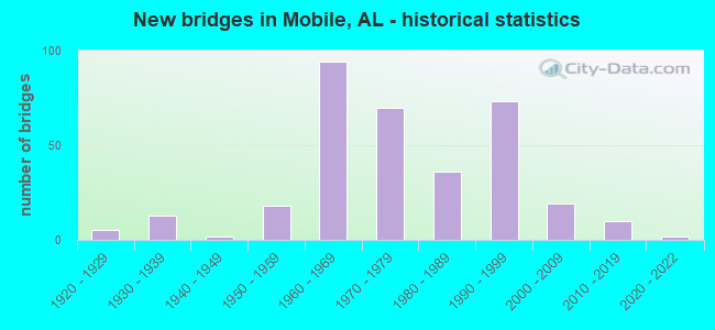
- New bridges - historical statistics
- 51920-1929
- 131930-1939
- 21940-1949
- 181950-1959
- 941960-1969
- 701970-1979
- 361980-1989
- 731990-1999
- 192000-2009
- 102010-2019
- 22020-2022
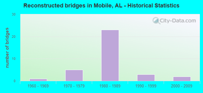
- Reconstructed bridges - Historical Statistics
- 11960-1969
- 51970-1979
- 231980-1989
- 31990-1999
- 22000-2009
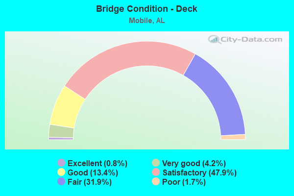
- Bridge Condition - Deck
- 0.8%Excellent
- 4.2%Very good
- 13.4%Good
- 47.9%Satisfactory
- 31.9%Fair
- 1.7%Poor
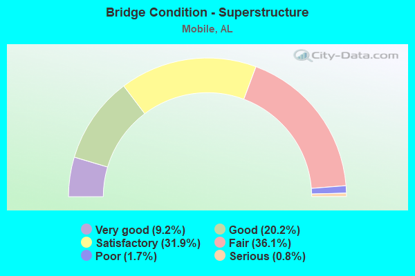
- Bridge Condition - Superstructure
- 9.2%Very good
- 20.2%Good
- 31.9%Satisfactory
- 36.1%Fair
- 1.7%Poor
- 0.8%Serious

- Bridge Condition - Substructure
- 5.0%Very good
- 23.5%Good
- 34.5%Satisfactory
- 32.8%Fair
- 2.5%Poor
- 1.7%Serious
- 0.8%Critical
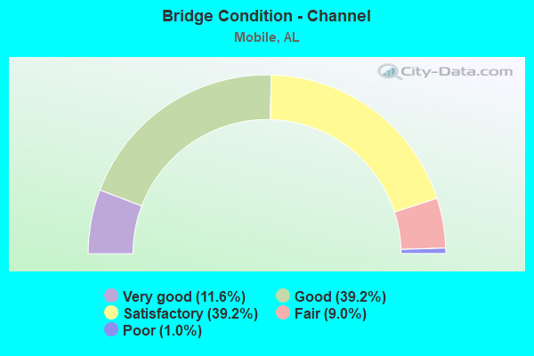
- Bridge Condition - Channel
- 11.6%Very good
- 39.2%Good
- 39.2%Satisfactory
- 9.0%Fair
- 1.0%Poor
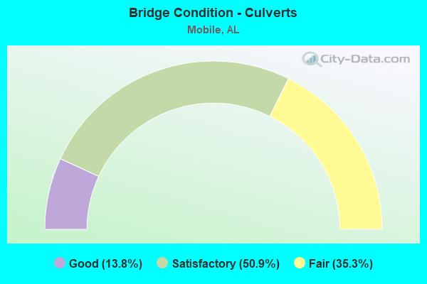
- Bridge Condition - Culverts
- 13.8%Good
- 50.9%Satisfactory
- 35.3%Fair
Find on map >> Show street view
Structure Number: 15207, Location: 1.0 MI E OF SNOW RD (Lat: 30.710253, Lng: -88.260092), Route carried "on" structure: County highway 70, Year Built: 1990, Status: Open, Structure Length: 1.27m (4.17ft), Average Daily Traffic: 10,781 (year 2020), Truck Traffic: 1%, Average Future Daily Traffic: 16,020 (year 2040), Design Load: HS 20, Features Intersected: PIERCE CREEK, Facility Carried by Structure: TANNER WILLIAMS RD
Minimum Vertical Clearance: 30+ m (98+ ft), Kilometerpoint: 0.999, Lanes on structure: 2, Owner: County Highway Agency, Approaching Roadway Width: 8.7m (28.5ft), Material/Design: Concrete continuous, Design/Construction: Culvert, Number Of Spans In Main Unit: 4, Length of Maximum Span: 3.0m (9.8ft)
Condition: Channel: Satisfactory, Culverts: Good, Operating Rating: 59.5 metric tons, Method Used To Determine Operating Rating: Load Factor (LF), Inventory Rating: 35.7 metric tons, Method Used To Determine Inventory Rating: Load Factor (LF), Structural Evaluation: Better than present minimum criteria, Waterway Adequacy: Equal to present desirable criteria, Approach Roadway Alignment: Equal to present desirable criteria, Length Of Structure Improvement: 1.95m (6.40ft), Designated Inspection Frequency: Every 24 months, Inspection Date: August 2020, Bridge Improvement Cost: $473,000, Roadway Improvement Cost: $47,000, Total Project Cost: $520,000 ( Estimate for 2022)
Find on map >> Show street view
Structure Number: 15227, Location: 0.3 MI W STANTON RD (Lat: 30.707725, Lng: -88.101056), Route carried "on" structure: City street , Year Built: 1990, Status: Open, Structure Length: 8.60m (28.22ft), Average Daily Traffic: 14,377 (year 2022), Truck Traffic: 1%, Average Future Daily Traffic: 20,128 (year 2042), Design Load: HS 20, Features Intersected: THREE MILE CREEK, Facility Carried by Structure: FILLINGIM ST
Minimum Vertical Clearance: 30+ m (98+ ft), Kilometerpoint: 0.299, Lanes on structure: 2, Owner: City or Municipal Highway Agency, Approaching Roadway Width: 8.4m (27.6ft), Material/Design: Prestressed concrete continuous, Design/Construction: Stringer/Multi-beam, Number Of Spans In Main Unit: 6, Length of Maximum Span: 14.3m (46.9ft), Curb or Sidewalk Widths: Left: 0.0m, Right: 1.5m (4.9ft), Curb-To-Curb Width: 8.4m (27.6ft), Out-to-Out Width: 10.3m (33.8ft)
Condition: Deck: Satisfactory, Superstructure: Good, Substructure: Satisfactory, Channel: Good, Operating Rating: 78.7 metric tons, Method Used To Determine Operating Rating: Load Factor (LF), Inventory Rating: 48.4 metric tons, Method Used To Determine Inventory Rating: Load Factor (LF), Structural Evaluation: Equal to present minimum criteria, Deck Geometry: High priority of corrective action, Waterway Adequacy: Better than present minimum criteria, Approach Roadway Alignment: Equal to present desirable criteria, Length Of Structure Improvement: 9.59m (31.46ft), Designated Inspection Frequency: Every 24 months, Inspection Date: Febuary 2022, Bridge Improvement Cost: $2,170,000, Roadway Improvement Cost: $217,000, Total Project Cost: $2,387,000 ( Estimate for 2022), Deck Structure Type: Concrete Cast-file-Place
Find on map >> Show street view
Structure Number: 15302, Location: 2.2 MI E US 90 (Lat: 30.604550, Lng: -88.148617), Route carried "on" structure: Interstate 10, Year Built: 1964, Year Reconstructed: 1991, Status: Open, Structure Length: 8.29m (27.20ft), Average Daily Traffic: 94,538 (year 2018), Truck Traffic: 15%, Average Future Daily Traffic: 141,807 (year 2038), Design Load: HS 20, Features Intersected: HALLS MILL CREEK
Minimum Vertical Clearance: 30+ m (98+ ft), Kilometerpoint: 28.695, Lanes on structure: 6, Base Highway Network: Yes, Owner: State Highway Agency, Approaching Roadway Width: 39.6m (129.9ft), Skew: 10 degrees, Material/Design: Concrete, Design/Construction: Tee Beam, Number Of Spans In Main Unit: 8, Length of Maximum Span: 10.4m (34.1ft), Curb-To-Curb Width: 39.6m (129.9ft), Out-to-Out Width: 41.7m (136.8ft)
Condition: Deck: Fair, Superstructure: Fair, Substructure: Fair, Channel: Satisfactory, Operating Rating: 46.8 metric tons, Method Used To Determine Operating Rating: Load Factor (LF), Inventory Rating: 28.0 metric tons, Method Used To Determine Inventory Rating: Load Factor (LF), Structural Evaluation: Somewhat better than minimum adequacy, Deck Geometry: Superior to present desirable criteria, Waterway Adequacy: Equal to present desirable criteria, Approach Roadway Alignment: Equal to present desirable criteria, Length Of Structure Improvement: 9.29m (30.48ft), Designated Inspection Frequency: Every 24 months, Underwater Inspection Frequency: Every 24 months, Inspection Date: May 2020, Underwater Inspection Date: October 2021, Bridge Improvement Cost: $8,661,000, Roadway Improvement Cost: $866,000, Total Project Cost: $9,527,000 ( Estimate for 2022), Deck Structure Type: Concrete Cast-file-Place
Find on map >> Show street view
Structure Number: 15303, Location: 3.9 MI E US 90 (Lat: 30.622478, Lng: -88.129897), Route carried "on" structure: Interstate 10, Year Built: 1964, Year Reconstructed: 1991, Status: Open, Structure Length: 6.22m (20.41ft), Average Daily Traffic: 94,538 (year 2018), Truck Traffic: 15%, Average Future Daily Traffic: 141,807 (year 2038), Design Load: HS 20, Features Intersected: MOORES CREEK
Minimum Vertical Clearance: 30+ m (98+ ft), Kilometerpoint: 31.318, Lanes on structure: 7, Base Highway Network: Yes, Owner: State Highway Agency, Approaching Roadway Width: 36.9m (121.1ft), Skew: 30 degrees, Material/Design: Concrete, Design/Construction: Tee Beam, Number Of Spans In Main Unit: 6, Length of Maximum Span: 10.4m (34.1ft), Curb-To-Curb Width: 36.1m (118.4ft), Out-to-Out Width: 37.0m (121.4ft)
Condition: Deck: Fair, Superstructure: Fair, Substructure: Fair, Channel: Satisfactory, Operating Rating: 46.8 metric tons, Method Used To Determine Operating Rating: Load Factor (LF), Inventory Rating: 28.0 metric tons, Method Used To Determine Inventory Rating: Load Factor (LF), Structural Evaluation: Somewhat better than minimum adequacy, Deck Geometry: Superior to present desirable criteria, Waterway Adequacy: Equal to present desirable criteria, Approach Roadway Alignment: Equal to present desirable criteria, Length Of Structure Improvement: 7.26m (23.82ft), Designated Inspection Frequency: Every 24 months, Underwater Inspection Frequency: Every 24 months, Inspection Date: May 2020, Underwater Inspection Date: October 2021, Bridge Improvement Cost: $6,022,000, Roadway Improvement Cost: $602,000, Total Project Cost: $6,624,000 ( Estimate for 2022), Deck Structure Type: Concrete Cast-file-Place
Find on map >> Show street view
Structure Number: 15368, Location: 0.5 MI S OLD MILITARY RD (Lat: 30.533500, Lng: -88.157944), Route carried "on" structure: City street , Year Built: 1991, Status: Open, Structure Length: 0.76m (2.49ft), Average Daily Traffic: 24 (year 2021), Average Future Daily Traffic: 36 (year 2041), Design Load: HS 20, Features Intersected: MUDDY CREEK, Facility Carried by Structure: BOWERS LANE
Minimum Vertical Clearance: 30+ m (98+ ft), Kilometerpoint: 0.010, Lanes on structure: 2, Owner: City or Municipal Highway Agency, Approaching Roadway Width: 6.1m (20.0ft), Skew: 1 degrees, Material/Design: Concrete continuous, Design/Construction: Culvert, Number Of Spans In Main Unit: 2, Length of Maximum Span: 3.7m (12.1ft)
Condition: Channel: Fair, Culverts: Good, Operating Rating: 47.4 metric tons, Method Used To Determine Operating Rating: Load Factor (LF), Inventory Rating: 28.4 metric tons, Method Used To Determine Inventory Rating: Load Factor (LF), Structural Evaluation: Better than present minimum criteria, Waterway Adequacy: Meets minimum limits, Approach Roadway Alignment: Better than present minimum criteria, Length Of Structure Improvement: 1.41m (4.63ft), Designated Inspection Frequency: Every 24 months, Inspection Date: December 2021, Bridge Improvement Cost: $382,000, Roadway Improvement Cost: $38,000, Total Project Cost: $420,000 ( Estimate for 2022)
Find on map >> Show street view
Structure Number: 1543, Location: 0.2 MI E US 43 (Lat: 30.733986, Lng: -88.044756), Route carried "on" structure: US 90, Year Built: 1991, Status: Open, Structure Length: 222.23m (729.10ft), Average Daily Traffic: 18,954 (year 2019), Truck Traffic: 11%, Average Future Daily Traffic: 28,431 (year 2039), Design Load: HS 20, Features Intersected: MOBILE RIVER
Minimum Vertical Clearance: 30+ m (98+ ft), Kilometerpoint: 52.056, Lanes on structure: 4, Lanes under structure: 6, Owner: State Highway Agency, Approaching Roadway Width: 24.4m (80.1ft), Skew: 30 degrees, Navigation Control: Yes ( Vertical Clearance: 12.2m (40.0ft), Horizontal Clearance: 182.9m (600.1ft)), Material/Design: Prestressed concrete continuous, Design/Construction: Stayed Girder, Number Of Spans In Main Unit: 3, Number Of Approach Spans: 30, Length of Maximum Span: 237.7m (779.9ft), Curb-To-Curb Width: 24.3m (79.7ft), Out-to-Out Width: 28.0m (91.9ft)
Condition: Deck: Satisfactory, Superstructure: Satisfactory, Substructure: Satisfactory, Channel: Good, Operating Rating: 62.7 metric tons, Method Used To Determine Operating Rating: Load Factor (LF), Inventory Rating: 37.6 metric tons, Method Used To Determine Inventory Rating: Load Factor (LF), Structural Evaluation: Equal to present minimum criteria, Deck Geometry: Superior to present desirable criteria, Underclear: Somewhat better than minimum adequacy, Waterway Adequacy: Superior to present desirable criteria, Approach Roadway Alignment: Better than present minimum criteria, Length Of Structure Improvement: 222.23m (729.10ft), Designated Inspection Frequency: Every 24 months, Underwater Inspection Frequency: Every 24 months, Inspection Date: May 2021, Underwater Inspection Date: October 2021, Bridge Improvement Cost: $140,191,000, Roadway Improvement Cost: $14,019,000, Total Project Cost: $154,210,000 ( Estimate for 2022), Deck Structure Type: Concrete Precast Panels
Find on map >> Show street view
Structure Number: 15431, Location: 1.08 MI. N. OLD SHELL RD (Lat: 30.705194, Lng: -88.174242), Route carried "on" structure: City street , Year Built: 1991, Status: Open, Structure Length: 3.75m (12.30ft), Average Daily Traffic: 22,494 (year 2021), Truck Traffic: 4%, Average Future Daily Traffic: 33,516 (year 2041), Design Load: HS 20, Features Intersected: THREE MILE CREEK, Facility Carried by Structure: UNIVERSITY BLVD.
Minimum Vertical Clearance: 30+ m (98+ ft), Kilometerpoint: 0.000, Lanes on structure: 5, Owner: City or Municipal Highway Agency, Approaching Roadway Width: 21.6m (70.9ft), Skew: 14 degrees, Material/Design: Concrete, Design/Construction: Culvert, Number Of Spans In Main Unit: 6, Length of Maximum Span: 4.3m (14.1ft), Curb or Sidewalk Widths: Left: 0.2m (0.7ft), Right: 0.2m (0.7ft)
Condition: Channel: Fair, Culverts: Fair, Operating Rating: 88.9 metric tons, Method Used To Determine Operating Rating: Load Factor (LF), Inventory Rating: 55.2 metric tons, Method Used To Determine Inventory Rating: Load Factor (LF), Structural Evaluation: Somewhat better than minimum adequacy, Waterway Adequacy: Better than present minimum criteria, Approach Roadway Alignment: Equal to present desirable criteria, Length Of Structure Improvement: 4.68m (15.35ft), Designated Inspection Frequency: Every 24 months, Inspection Date: October 2021, Bridge Improvement Cost: $3,944,000, Roadway Improvement Cost: $394,000, Total Project Cost: $4,338,000 ( Estimate for 2022)
Find on map >> Show street view
Structure Number: 15432, Location: 1.20 MI. N. OLD SHELL RD (Lat: 30.706731, Lng: -88.173989), Route carried "on" structure: City street , Year Built: 1991, Status: Open, Structure Length: 0.64m (2.10ft), Average Daily Traffic: 22,494 (year 2021), Truck Traffic: 4%, Average Future Daily Traffic: 33,516 (year 2041), Design Load: HS 20, Features Intersected: DRAINAGE DITCH, Facility Carried by Structure: UNIVERSITY BLVD
Minimum Vertical Clearance: 30+ m (98+ ft), Kilometerpoint: 0.000, Lanes on structure: 5, Owner: City or Municipal Highway Agency, Approaching Roadway Width: 19.8m (65.0ft), Skew: 10 degrees, Material/Design: Concrete, Design/Construction: Culvert, Length of Maximum Span: 3.0m (9.8ft), Curb or Sidewalk Widths: Left: 0.5m (1.6ft), Right: 0.5m (1.6ft), Curb-To-Curb Width: 19.8m (65.0ft), Out-to-Out Width: 31.0m (101.7ft)
Condition: Channel: Good, Culverts: Satisfactory, Operating Rating: 88.9 metric tons, Method Used To Determine Operating Rating: Load Factor (LF), Inventory Rating: 69.0 metric tons, Method Used To Determine Inventory Rating: Load Factor (LF), Structural Evaluation: Equal to present minimum criteria, Deck Geometry: Meets minimum limits, Waterway Adequacy: Equal to present minimum criteria, Approach Roadway Alignment: Equal to present desirable criteria, Length Of Structure Improvement: 1.26m (4.13ft), Designated Inspection Frequency: Every 24 months, Inspection Date: December 2021, Bridge Improvement Cost: $735,000, Roadway Improvement Cost: $74,000, Total Project Cost: $809,000 ( Estimate for 2022)
Find on map >> Show street view
Structure Number: 15433, Location: 0.8 MI N JCT US 98 (Lat: 30.700472, Lng: -88.077189), Route carried "on" structure: US 45, Year Built: 1991, Status: Open, Structure Length: 7.50m (24.61ft), Average Daily Traffic: 12,914 (year 2018), Truck Traffic: 2%, Average Future Daily Traffic: 19,371 (year 2038), Design Load: HS 20, Features Intersected: THREE MILE CREEK
Minimum Vertical Clearance: 30+ m (98+ ft), Kilometerpoint: 1.479, Lanes on structure: 5, Base Highway Network: Yes, Owner: State Highway Agency, Approaching Roadway Width: 21.0m (68.9ft), Material/Design: Prestressed concrete, Design/Construction: Box Beam or Girders - Multiple, Number Of Spans In Main Unit: 6, Length of Maximum Span: 12.5m (41.0ft), Curb or Sidewalk Widths: Left: 0.0m, Right: 1.4m (4.6ft), Curb-To-Curb Width: 21.0m (68.9ft), Out-to-Out Width: 23.2m (76.1ft)
Condition: Deck: Satisfactory, Superstructure: Good, Substructure: Good, Channel: Good, Operating Rating: 88.9 metric tons, Method Used To Determine Operating Rating: Load Factor (LF), Inventory Rating: 63.5 metric tons, Method Used To Determine Inventory Rating: Load Factor (LF), Structural Evaluation: Better than present minimum criteria, Deck Geometry: Somewhat better than minimum adequacy, Waterway Adequacy: Equal to present minimum criteria, Approach Roadway Alignment: Equal to present minimum criteria, Length Of Structure Improvement: 8.52m (27.95ft), Designated Inspection Frequency: Every 24 months, Underwater Inspection Frequency: Every 24 months, Inspection Date: July 2020, Underwater Inspection Date: January 2021, Bridge Improvement Cost: $4,440,000, Roadway Improvement Cost: $444,000, Total Project Cost: $4,884,000 ( Estimate for 2022), Deck Structure Type: Concrete Precast Panels
Find on map >> Show street view
Structure Number: 15508, Location: DN TWN MOB TO CHICKASAW (Lat: 30.752197, Lng: -88.092150), Route carried "on" structure: Interstate 165, Year Built: 1994, Status: Open, Structure Length: 747.16m (2451.31ft), Average Daily Traffic: 22,113 (year 2019), Truck Traffic: 9%, Average Future Daily Traffic: 33,170 (year 2039), Design Load: HS 20, Features Intersected: MULTIPLE STREETS,STREAMS
Minimum Vertical Clearance: 30+ m (98+ ft), Kilometerpoint: 0.161, Lanes on structure: 3, Lanes under structure: 48, Base Highway Network: Yes, Owner: State Highway Agency, Approaching Roadway Width: 34.1m (111.9ft), Skew: 30 degrees, Material/Design: Prestressed concrete continuous, Design/Construction: Stringer/Multi-beam, Number Of Spans In Main Unit: 122, Number Of Approach Spans: 193, Length of Maximum Span: 59.7m (195.9ft), Curb-To-Curb Width: 17.1m (56.1ft), Out-to-Out Width: 17.9m (58.7ft)
Condition: Deck: Satisfactory, Superstructure: Fair, Substructure: Good, Channel: Good, Operating Rating: 32.7 metric tons, Method Used To Determine Operating Rating: Load Factor (LF), Inventory Rating: 19.4 metric tons, Method Used To Determine Inventory Rating: Load Factor (LF), Structural Evaluation: Meets minimum limits, Deck Geometry: Equal to present minimum criteria, Underclear: Equal to present minimum criteria, Waterway Adequacy: Superior to present desirable criteria, Approach Roadway Alignment: Equal to present desirable criteria, Length Of Structure Improvement: 747.16m (2451.31ft), Designated Inspection Frequency: Every 24 months, Critical Feature Inspection Frequency: Every 24 months, Underwater Inspection Frequency: Every 48 months, Inspection Date: December 2020, Critical Feature Inspection Date: December 2020, Underwater Inspection Date: May 2019, Bridge Improvement Cost: $297,147,000, Roadway Improvement Cost: $29,715,000, Total Project Cost: $326,862,000 ( Estimate for 2022), Deck Structure Type: Concrete Cast-file-Place
Find on map >> Show street view
Structure Number: 15519, Location: 1.2 MI N JEFF HAMILTON RD (Lat: 30.642175, Lng: -88.295906), Route carried "on" structure: County highway , Year Built: 1992, Status: Open, Structure Length: 3.66m (12.01ft), Average Daily Traffic: 120 (year 2020), Average Future Daily Traffic: 178 (year 2040), Design Load: HS 20, Features Intersected: MILLER CREEK, Facility Carried by Structure: JOHNSON ROAD W
Minimum Vertical Clearance: 30+ m (98+ ft), Kilometerpoint: 1.199, Lanes on structure: 2, Owner: County Highway Agency, Approaching Roadway Width: 9.8m (32.2ft), Material/Design: Concrete, Design/Construction: Channel Beam, Number Of Spans In Main Unit: 5, Length of Maximum Span: 7.3m (24.0ft), Curb-To-Curb Width: 8.5m (27.9ft), Out-to-Out Width: 8.5m (27.9ft)
Condition: Deck: Satisfactory, Superstructure: Satisfactory, Substructure: Fair, Channel: Good, Operating Rating: 66.9 metric tons, Method Used To Determine Operating Rating: Load Factor (LF), Inventory Rating: 40.0 metric tons, Method Used To Determine Inventory Rating: Load Factor (LF), Structural Evaluation: Somewhat better than minimum adequacy, Deck Geometry: Equal to present minimum criteria, Waterway Adequacy: Better than present minimum criteria, Approach Roadway Alignment: Better than present minimum criteria, Length Of Structure Improvement: 4.58m (15.03ft), Designated Inspection Frequency: Every 24 months, Underwater Inspection Frequency: Every 24 months, Inspection Date: June 2020, Underwater Inspection Date: June 2020, Bridge Improvement Cost: $879,000, Roadway Improvement Cost: $88,000, Total Project Cost: $967,000 ( Estimate for 2022), Deck Structure Type: Concrete Precast Panels
Find on map >> Show street view
Structure Number: 15574, Location: CHICKASAW TO DWN TWN MOB (Lat: 30.751758, Lng: -88.092489), Route carried "on" structure: Interstate 165, Year Built: 1994, Status: Open, Structure Length: 741.70m (2433.40ft), Average Daily Traffic: 22,113 (year 2019), Truck Traffic: 9%, Average Future Daily Traffic: 33,170 (year 2039), Design Load: HS 20, Features Intersected: MULTIPLE STREETS,STREAMS
Minimum Vertical Clearance: 30+ m (98+ ft), Kilometerpoint: 0.161, Lanes on structure: 3, Lanes under structure: 56, Base Highway Network: Yes, Owner: State Highway Agency, Approaching Roadway Width: 17.1m (56.1ft), Skew: 30 degrees, Material/Design: Prestressed concrete continuous, Design/Construction: Stringer/Multi-beam, Number Of Spans In Main Unit: 122, Number Of Approach Spans: 195, Length of Maximum Span: 59.7m (195.9ft), Curb-To-Curb Width: 17.1m (56.1ft), Out-to-Out Width: 17.9m (58.7ft)
Condition: Deck: Satisfactory, Superstructure: Satisfactory, Substructure: Good, Channel: Good, Operating Rating: 32.7 metric tons, Method Used To Determine Operating Rating: Load Factor (LF), Inventory Rating: 19.6 metric tons, Method Used To Determine Inventory Rating: Load Factor (LF), Structural Evaluation: Meets minimum limits, Deck Geometry: Equal to present minimum criteria, Underclear: Equal to present minimum criteria, Waterway Adequacy: Superior to present desirable criteria, Approach Roadway Alignment: Equal to present desirable criteria, Length Of Structure Improvement: 741.70m (2433.40ft), Designated Inspection Frequency: Every 24 months, Critical Feature Inspection Frequency: Every 24 months, Underwater Inspection Frequency: Every 48 months, Inspection Date: December 2020, Critical Feature Inspection Date: December 2020, Underwater Inspection Date: May 2019, Bridge Improvement Cost: $294,977,000, Roadway Improvement Cost: $29,498,000, Total Project Cost: $324,475,000 ( Estimate for 2022), Deck Structure Type: Concrete Cast-file-Place
Find on map >> Show street view
Structure Number: 15871, Location: 1.3 MI. W. US 98 (Lat: 30.719750, Lng: -88.175697), Route carried "on" structure: City street , Year Built: 1991, Status: Open, Structure Length: 1.01m (3.31ft), Average Daily Traffic: 8,345 (year 2021), Truck Traffic: 1%, Average Future Daily Traffic: 12,434 (year 2041), Design Load: HS 20, Features Intersected: BRANCH, Facility Carried by Structure: OVERLOOK ROAD
Minimum Vertical Clearance: 30+ m (98+ ft), Kilometerpoint: 1.899, Lanes on structure: 2, Owner: City or Municipal Highway Agency, Approaching Roadway Width: 10.4m (34.1ft), Material/Design: Concrete, Design/Construction: Culvert, Number Of Spans In Main Unit: 3, Length of Maximum Span: 3.0m (9.8ft), Curb or Sidewalk Widths: Left: 0.2m (0.7ft), Right: 0.2m (0.7ft)
Condition: Channel: Good, Culverts: Satisfactory, Operating Rating: 85.0 metric tons, Method Used To Determine Operating Rating: Load Factor (LF), Inventory Rating: 51.0 metric tons, Method Used To Determine Inventory Rating: Load Factor (LF), Structural Evaluation: Equal to present minimum criteria, Waterway Adequacy: Better than present minimum criteria, Approach Roadway Alignment: Equal to present desirable criteria, Length Of Structure Improvement: 1.68m (5.51ft), Designated Inspection Frequency: Every 24 months, Inspection Date: September 2021, Bridge Improvement Cost: $456,000, Roadway Improvement Cost: $46,000, Total Project Cost: $502,000 ( Estimate for 2022)
Find on map >> Show street view
Structure Number: 15977, Location: 5.8 MI S I-10 (Lat: 30.560383, Lng: -88.089319), Route carried "on" structure: State highway 163, Year Built: 1995, Status: Open, Structure Length: 112.32m (368.50ft), Average Daily Traffic: 7,791 (year 2019), Truck Traffic: 8%, Average Future Daily Traffic: 11,687 (year 2039), Design Load: HS 20, Features Intersected: DOG RIVER
Minimum Vertical Clearance: 30+ m (98+ ft), Kilometerpoint: 4.064, Lanes on structure: 4, Lanes under structure: 10, Owner: State Highway Agency, Approaching Roadway Width: 21.6m (70.9ft), Skew: 20 degrees, Navigation Control: Yes ( Vertical Clearance: 22.3m (73.2ft), Horizontal Clearance: 47.5m (155.8ft)), Material/Design: Steel continuous, Design/Construction: Stringer/Multi-beam, Number Of Spans In Main Unit: 3, Number Of Approach Spans: 36, Length of Maximum Span: 54.9m (180.1ft), Curb-To-Curb Width: 21.9m (71.9ft), Out-to-Out Width: 22.9m (75.1ft)
Condition: Deck: Satisfactory, Superstructure: Satisfactory, Substructure: Good, Channel: Good, Operating Rating: 70.3 metric tons, Method Used To Determine Operating Rating: Load Factor (LF), Inventory Rating: 38.5 metric tons, Method Used To Determine Inventory Rating: Load Factor (LF), Structural Evaluation: Equal to present minimum criteria, Deck Geometry: Superior to present desirable criteria, Underclear: Meets minimum limits, Waterway Adequacy: Equal to present minimum criteria, Approach Roadway Alignment: Better than present minimum criteria, Length Of Structure Improvement: 112.32m (368.50ft), Designated Inspection Frequency: Every 24 months, Underwater Inspection Frequency: Every 24 months, Inspection Date: May 2021, Underwater Inspection Date: June 2021, Bridge Improvement Cost: $57,762,000, Roadway Improvement Cost: $5,776,000, Total Project Cost: $63,538,000 ( Estimate for 2022), Deck Structure Type: Concrete Cast-file-Place
Find on map >> Show street view
Structure Number: 16035, Location: MOBILE/BALDWIN CO LINE (Lat: 30.684917, Lng: -88.010794), Route carried "on" structure: US 90, Year Built: 1998, Status: Open, Structure Length: 44.21m (145.05ft), Average Daily Traffic: 12,697 (year 2020), Truck Traffic: 4%, Average Future Daily Traffic: 19,045 (year 2040), Design Load: HS 20, Features Intersected: TENSAW/SPANISH RIVER
Minimum Vertical Clearance: 30+ m (98+ ft), Kilometerpoint: 60.099, Lanes on structure: 2, Owner: State Highway Agency, Approaching Roadway Width: 11.4m (37.4ft), Skew: 10 degrees, Navigation Control: Yes ( Vertical Clearance: 8.0m (26.2ft), Horizontal Clearance: 35.0m (114.8ft)), Material/Design: Prestressed concrete, Design/Construction: Stringer/Multi-beam, Number Of Spans In Main Unit: 5, Number Of Approach Spans: 6, Length of Maximum Span: 42.7m (140.1ft), Curb-To-Curb Width: 12.1m (39.7ft), Out-to-Out Width: 13.0m (42.7ft)
Condition: Deck: Satisfactory, Superstructure: Satisfactory, Substructure: Good, Channel: Good, Operating Rating: 82.9 metric tons, Method Used To Determine Operating Rating: Load Factor (LF), Inventory Rating: 52.3 metric tons, Method Used To Determine Inventory Rating: Load Factor (LF), Structural Evaluation: Equal to present minimum criteria, Deck Geometry: Better than present minimum criteria, Waterway Adequacy: Equal to present desirable criteria, Approach Roadway Alignment: Better than present minimum criteria, Length Of Structure Improvement: 44.21m (145.05ft), Designated Inspection Frequency: Every 24 months, Underwater Inspection Frequency: Every 24 months, Inspection Date: September 2021, Underwater Inspection Date: March 2021, Bridge Improvement Cost: $12,732,000, Roadway Improvement Cost: $1,273,000, Total Project Cost: $14,005,000 ( Estimate for 2022), Deck Structure Type: Concrete Cast-file-Place
Find on map >> Show street view
Structure Number: 16182, Location: 2.6 MI N BANKHEAD TUNNEL (Lat: 30.723769, Lng: -88.058772), Route carried "on" structure: City street , Year Built: 1995, Status: Open, Structure Length: 9.75m (31.99ft), Average Daily Traffic: 1,761 (year 2022), Truck Traffic: 4%, Average Future Daily Traffic: 2,625 (year 2042), Design Load: HS 20, Features Intersected: THREE MILE CREEK, Facility Carried by Structure: US 43
Minimum Vertical Clearance: 30+ m (98+ ft), Kilometerpoint: 0.000, Lanes on structure: 4, Owner: City or Municipal Highway Agency, Approaching Roadway Width: 20.7m (67.9ft), Material/Design: Prestressed concrete, Design/Construction: Stringer/Multi-beam, Number Of Spans In Main Unit: 4, Length of Maximum Span: 24.4m (80.1ft), Curb-To-Curb Width: 19.5m (64.0ft), Out-to-Out Width: 20.4m (66.9ft)
Condition: Deck: Satisfactory, Superstructure: Good, Substructure: Good, Channel: Good, Operating Rating: 77.3 metric tons, Method Used To Determine Operating Rating: Load Factor (LF), Inventory Rating: 46.6 metric tons, Method Used To Determine Inventory Rating: Load Factor (LF), Structural Evaluation: Better than present minimum criteria, Deck Geometry: Better than present minimum criteria, Waterway Adequacy: Equal to present desirable criteria, Approach Roadway Alignment: Equal to present desirable criteria, Length Of Structure Improvement: 10.69m (35.07ft), Designated Inspection Frequency: Every 24 months, Underwater Inspection Frequency: Every 48 months, Inspection Date: Febuary 2022, Underwater Inspection Date: Febuary 2020, Bridge Improvement Cost: $4,913,000, Roadway Improvement Cost: $491,000, Total Project Cost: $5,404,000 ( Estimate for 2022), Deck Structure Type: Concrete Cast-file-Place
Find on map >> Show street view
Structure Number: 16291, Location: 0.4 MI W OF OVERLOOK RD (Lat: 30.720750, Lng: -88.162469), Route carried "on" structure: US 98, Year Built: 1997, Status: Open, Structure Length: 7.44m (24.41ft), Average Daily Traffic: 34,444 (year 2018), Truck Traffic: 6%, Average Future Daily Traffic: 51,666 (year 2038), Design Load: HS 20, Features Intersected: UNIVERSITY BLVD.
Minimum Vertical Clearance: 30+ m (98+ ft), Kilometerpoint: 30.764, Lanes on structure: 5, Lanes under structure: 5, Base Highway Network: Yes, Owner: State Highway Agency, Approaching Roadway Width: 28.0m (91.9ft), Skew: 2 degrees, Material/Design: Prestressed concrete, Design/Construction: Stringer/Multi-beam, Number Of Spans In Main Unit: 1, Number Of Approach Spans: 2, Length of Maximum Span: 40.2m (131.9ft), Curb or Sidewalk Widths: Left: 0.0m, Right: 1.7m (5.6ft), Curb-To-Curb Width: 29.0m (95.1ft), Out-to-Out Width: 29.5m (96.8ft)
Condition: Deck: Good, Superstructure: Good, Substructure: Good, Operating Rating: 72.8 metric tons, Method Used To Determine Operating Rating: Load Factor (LF), Inventory Rating: 48.9 metric tons, Method Used To Determine Inventory Rating: Load Factor (LF), Structural Evaluation: Better than present minimum criteria, Deck Geometry: Superior to present desirable criteria, Underclear: High priority of corrective action, Approach Roadway Alignment: Equal to present desirable criteria, Length Of Structure Improvement: 8.46m (27.76ft), Designated Inspection Frequency: Every 24 months, Inspection Date: August 2020, Bridge Improvement Cost: $5,569,000, Roadway Improvement Cost: $557,000, Total Project Cost: $6,126,000 ( Estimate for 2022), Deck Structure Type: Concrete Cast-file-Place
Find on map >> Show street view
Structure Number: 16421, Location: 0.2 MI N ZEIGLER BLVD (Lat: 30.716294, Lng: -88.165417), Route carried "on" structure: City street , Year Built: 1998, Status: Open, Structure Length: 1.25m (4.10ft), Average Daily Traffic: 17,869 (year 2021), Truck Traffic: 20%, Average Future Daily Traffic: 26,625 (year 2041), Features Intersected: BRANCH, Facility Carried by Structure: UNIVERSITY BLVD
Minimum Vertical Clearance: 7.56m (24.80ft), Kilometerpoint: 0.000, Lanes on structure: 5, Owner: City or Municipal Highway Agency, Approaching Roadway Width: 7.8m (25.6ft), Skew: 20 degrees, Material/Design: Concrete continuous, Design/Construction: Culvert, Number Of Spans In Main Unit: 4, Length of Maximum Span: 3.0m (9.8ft), Curb or Sidewalk Widths: Left: 0.1m (0.3ft), Right: 0.1m (0.3ft)
Condition: Channel: Satisfactory, Culverts: Satisfactory, Operating Rating: 85.2 metric tons, Method Used To Determine Operating Rating: Load Factor (LF), Inventory Rating: 51.1 metric tons, Method Used To Determine Inventory Rating: Load Factor (LF), Structural Evaluation: Equal to present minimum criteria, Waterway Adequacy: Equal to present minimum criteria, Approach Roadway Alignment: Equal to present desirable criteria, Length Of Structure Improvement: 1.92m (6.30ft), Designated Inspection Frequency: Every 24 months, Inspection Date: September 2021, Bridge Improvement Cost: $1,000,000, Roadway Improvement Cost: $100,000, Total Project Cost: $1,100,000 ( Estimate for 2022)
Find on map >> Show street view
Structure Number: 16462, Location: 0.4 MI W DEMETROPOLIS RD (Lat: 30.606975, Lng: -88.160122), Route carried "on" structure: City street , Year Built: 1996, Status: Open, Structure Length: 4.57m (14.99ft), Average Daily Traffic: 9,032 (year 2021), Truck Traffic: 4%, Average Future Daily Traffic: 13,458 (year 2041), Design Load: HS 20, Features Intersected: HALLS MILL CREEK, Facility Carried by Structure: HALLS MILL RD
Minimum Vertical Clearance: 30+ m (98+ ft), Kilometerpoint: 0.010, Lanes on structure: 2, Owner: City or Municipal Highway Agency, Approaching Roadway Width: 7.6m (24.9ft), Material/Design: Concrete, Design/Construction: Channel Beam, Number Of Spans In Main Unit: 5, Length of Maximum Span: 10.4m (34.1ft), Curb-To-Curb Width: 10.8m (35.4ft), Out-to-Out Width: 11.4m (37.4ft)
Condition: Deck: Fair, Superstructure: Fair, Substructure: Fair, Channel: Satisfactory, Operating Rating: 65.3 metric tons, Method Used To Determine Operating Rating: Load Factor (LF), Inventory Rating: 39.1 metric tons, Method Used To Determine Inventory Rating: Load Factor (LF), Structural Evaluation: Somewhat better than minimum adequacy, Deck Geometry: Meets minimum limits, Waterway Adequacy: Somewhat better than minimum adequacy, Approach Roadway Alignment: Better than present minimum criteria, Length Of Structure Improvement: 5.56m (18.24ft), Designated Inspection Frequency: Every 24 months, Inspection Date: November 2021, Bridge Improvement Cost: $1,412,000, Roadway Improvement Cost: $141,000, Total Project Cost: $1,553,000 ( Estimate for 2022), Deck Structure Type: Concrete Precast Panels
Find on map >> Show street view
Structure Number: 16555, Location: 0.4MI E CODY RD (Lat: 30.640308, Lng: -88.201342), Route carried "on" structure: City street , Year Built: 1995, Status: Open, Structure Length: 3.44m (11.29ft), Average Daily Traffic: 29,843 (year 2021), Truck Traffic: 4%, Average Future Daily Traffic: 44,466 (year 2041), Design Load: H 20, Features Intersected: MILKHOUSE CREEK, Facility Carried by Structure: COTTAGE HILL ROAD
Minimum Vertical Clearance: 30+ m (98+ ft), Kilometerpoint: 0.399, Lanes on structure: 5, Owner: City or Municipal Highway Agency, Approaching Roadway Width: 18.7m (61.4ft), Material/Design: Concrete, Design/Construction: Culvert, Number Of Spans In Main Unit: 9, Length of Maximum Span: 3.7m (12.1ft)
Condition: Channel: Satisfactory, Culverts: Satisfactory, Operating Rating: 88.9 metric tons, Method Used To Determine Operating Rating: Load Factor (LF), Inventory Rating: 59.6 metric tons, Method Used To Determine Inventory Rating: Load Factor (LF), Structural Evaluation: Equal to present minimum criteria, Waterway Adequacy: Better than present minimum criteria, Approach Roadway Alignment: Better than present minimum criteria, Length Of Structure Improvement: 4.34m (14.24ft), Designated Inspection Frequency: Every 24 months, Inspection Date: October 2021, Bridge Improvement Cost: $2,379,000, Roadway Improvement Cost: $238,000, Total Project Cost: $2,617,000 ( Estimate for 2022), Deck Structure Type: Concrete Cast-file-Place, Wearing Surface/Protective System: Wearing Surface: Bituminous
Find on map >> Show street view
Structure Number: 17071, Location: 0.38MI W OF CODY RD (Lat: 30.654017, Lng: -88.213889), Route carried "on" structure: County highway , Year Built: 1997, Status: Open, Structure Length: 1.55m (5.09ft), Average Daily Traffic: 1,550 (year 2020), Truck Traffic: 7%, Average Future Daily Traffic: 2,303 (year 2040), Design Load: HS 20, Features Intersected: TRIB TO SECOND CREEK, Facility Carried by Structure: CREEKWOOD DRIVE
Minimum Vertical Clearance: 30+ m (98+ ft), Kilometerpoint: 0.000, Lanes on structure: 2, Owner: County Highway Agency, Approaching Roadway Width: 7.9m (25.9ft), Material/Design: Concrete continuous, Design/Construction: Culvert, Number Of Spans In Main Unit: 4, Length of Maximum Span: 3.7m (12.1ft)
Condition: Channel: Good, Culverts: Satisfactory, Operating Rating: 61.3 metric tons, Method Used To Determine Operating Rating: Load Factor (LF), Inventory Rating: 36.7 metric tons, Method Used To Determine Inventory Rating: Load Factor (LF), Structural Evaluation: Equal to present minimum criteria, Waterway Adequacy: Equal to present desirable criteria, Approach Roadway Alignment: Equal to present minimum criteria, Length Of Structure Improvement: 2.23m (7.32ft), Designated Inspection Frequency: Every 24 months, Inspection Date: July 2020, Bridge Improvement Cost: $1,032,000, Roadway Improvement Cost: $103,000, Total Project Cost: $1,135,000 ( Estimate for 2022), Wearing Surface/Protective System: Wearing Surface: Bituminous
Find on map >> Show street view
Structure Number: 17171, Location: 1.6 MI N HAMILTON BLVD (Lat: 30.572556, Lng: -88.134400), Route carried "on" structure: State highway 193, Year Built: 1999, Status: Open, Structure Length: 17.43m (57.19ft), Average Daily Traffic: 12,561 (year 2018), Truck Traffic: 11%, Average Future Daily Traffic: 18,842 (year 2038), Design Load: HS 20, Features Intersected: RABBIT CREEK
Minimum Vertical Clearance: 30+ m (98+ ft), Kilometerpoint: 36.801, Lanes on structure: 2, Base Highway Network: Yes, Owner: State Highway Agency, Approaching Roadway Width: 11.4m (37.4ft), Skew: 10 degrees, Material/Design: Prestressed concrete, Design/Construction: Stringer/Multi-beam, Number Of Spans In Main Unit: 14, Length of Maximum Span: 12.5m (41.0ft), Curb-To-Curb Width: 12.1m (39.7ft), Out-to-Out Width: 13.0m (42.7ft)
Condition: Deck: Good, Superstructure: Good, Substructure: Good, Channel: Good, Operating Rating: 62.4 metric tons, Method Used To Determine Operating Rating: Load Factor (LF), Inventory Rating: 37.4 metric tons, Method Used To Determine Inventory Rating: Load Factor (LF), Structural Evaluation: Better than present minimum criteria, Deck Geometry: Better than present minimum criteria, Waterway Adequacy: Better than present minimum criteria, Approach Roadway Alignment: Equal to present desirable criteria, Length Of Structure Improvement: 18.14m (59.51ft), Designated Inspection Frequency: Every 24 months, Underwater Inspection Frequency: Every 24 months, Inspection Date: August 2020, Underwater Inspection Date: October 2020, Bridge Improvement Cost: $5,224,000, Roadway Improvement Cost: $522,000, Total Project Cost: $5,746,000 ( Estimate for 2022), Deck Structure Type: Concrete Cast-file-Place
Find on map >> Show street view
Structure Number: 17172, Location: 1.2 MI S I-10 (Lat: 30.581331, Lng: -88.140292), Route carried "on" structure: State highway 193, Year Built: 2000, Status: Open, Structure Length: 36.21m (118.80ft), Average Daily Traffic: 12,561 (year 2018), Truck Traffic: 11%, Average Future Daily Traffic: 18,842 (year 2038), Design Load: HS 20, Features Intersected: RATTLESNAKE BAYOU
Minimum Vertical Clearance: 30+ m (98+ ft), Kilometerpoint: 37.927, Lanes on structure: 2, Base Highway Network: Yes, Owner: State Highway Agency, Approaching Roadway Width: 11.4m (37.4ft), Skew: 10 degrees, Material/Design: Prestressed concrete, Design/Construction: Stringer/Multi-beam, Number Of Spans In Main Unit: 29, Length of Maximum Span: 12.5m (41.0ft), Curb-To-Curb Width: 12.1m (39.7ft), Out-to-Out Width: 12.9m (42.3ft)
Condition: Deck: Satisfactory, Superstructure: Good, Substructure: Good, Channel: Good, Operating Rating: 62.4 metric tons, Method Used To Determine Operating Rating: Load Factor (LF), Inventory Rating: 37.4 metric tons, Method Used To Determine Inventory Rating: Load Factor (LF), Structural Evaluation: Better than present minimum criteria, Deck Geometry: Better than present minimum criteria, Waterway Adequacy: Equal to present desirable criteria, Approach Roadway Alignment: Better than present minimum criteria, Length Of Structure Improvement: 36.21m (118.80ft), Designated Inspection Frequency: Every 24 months, Underwater Inspection Frequency: Every 24 months, Inspection Date: August 2020, Underwater Inspection Date: October 2020, Bridge Improvement Cost: $10,428,000, Roadway Improvement Cost: $1,043,000, Total Project Cost: $11,471,000 ( Estimate for 2022), Deck Structure Type: Concrete Cast-file-Place
Find on map >> Show street view
Structure Number: 17173, Location: 0.7 MI S I-10 (Lat: 30.588678, Lng: -88.145239), Route carried "on" structure: State highway 193, Year Built: 1999, Status: Open, Structure Length: 17.28m (56.69ft), Average Daily Traffic: 12,672 (year 2019), Truck Traffic: 9%, Average Future Daily Traffic: 19,008 (year 2039), Design Load: HS 20, Features Intersected: CSX RR / TILLMANS CRN
Minimum Vertical Clearance: 30+ m (98+ ft), Kilometerpoint: 39.846, Lanes on structure: 2, Lanes under structure: 4, Base Highway Network: Yes, Owner: State Highway Agency, Approaching Roadway Width: 9.8m (32.2ft), Skew: 13 degrees, Material/Design: Steel continuous, Design/Construction: Stringer/Multi-beam, Number Of Spans In Main Unit: 5, Number Of Approach Spans: 2, Length of Maximum Span: 31.4m (103.0ft), Curb-To-Curb Width: 12.1m (39.7ft), Out-to-Out Width: 13.0m (42.7ft)
Condition: Deck: Satisfactory, Superstructure: Good, Substructure: Good, Operating Rating: 58.2 metric tons, Method Used To Determine Operating Rating: Load Factor (LF), Inventory Rating: 34.8 metric tons, Method Used To Determine Inventory Rating: Load Factor (LF), Structural Evaluation: Better than present minimum criteria, Deck Geometry: Better than present minimum criteria, Underclear: High priority of corrective action, Approach Roadway Alignment: Equal to present desirable criteria, Length Of Structure Improvement: 17.99m (59.02ft), Designated Inspection Frequency: Every 24 months, Inspection Date: January 2021, Bridge Improvement Cost: $5,182,000, Roadway Improvement Cost: $518,000, Total Project Cost: $5,700,000 ( Estimate for 2022), Deck Structure Type: Concrete Cast-file-Place
Find on map >> Show street view
Structure Number: 17177, Location: .07 KM W OF MCVAY DRIVE (Lat: 30.649869, Lng: -88.113997), Route carried "on" structure: Bypass City street , Year Built: 1997, Status: Open, Structure Length: 0.81m (2.66ft), Average Daily Traffic: 1,497 (year 2022), Truck Traffic: 10%, Average Future Daily Traffic: 3,002 (year 2042), Design Load: HS 20, Features Intersected: BOLTON'S BRANCH TRIBUTAR, Facility Carried by Structure: BOLLING BROTHERS B
Minimum Vertical Clearance: 7.56m (24.80ft), Kilometerpoint: 0.000, Lanes on structure: 4, Owner: City or Municipal Highway Agency, Approaching Roadway Width: 7.8m (25.6ft), Skew: 21 degrees, Material/Design: Concrete, Design/Construction: Culvert, Number Of Spans In Main Unit: 2, Length of Maximum Span: 3.7m (12.1ft), Curb or Sidewalk Widths: Left: 0.2m (0.7ft), Right: 0.2m (0.7ft)
Condition: Channel: Good, Culverts: Good, Operating Rating: 69.1 metric tons, Method Used To Determine Operating Rating: Load Factor (LF), Inventory Rating: 41.4 metric tons, Method Used To Determine Inventory Rating: Load Factor (LF), Structural Evaluation: Better than present minimum criteria, Waterway Adequacy: Better than present minimum criteria, Approach Roadway Alignment: Better than present minimum criteria, Length Of Structure Improvement: 1.47m (4.82ft), Designated Inspection Frequency: Every 24 months, Inspection Date: January 2022, Bridge Improvement Cost: $704,000, Roadway Improvement Cost: $70,000, Total Project Cost: $774,000 ( Estimate for 2022)
Find on map >> Show street view
Structure Number: 17199, Location: 0.8KM S OF US HWY 90 (Lat: 30.652436, Lng: -88.117717), Route carried "on" structure: City street , Year Built: 2000, Status: Open, Structure Length: 0.82m (2.69ft), Average Daily Traffic: 2,983 (year 2022), Truck Traffic: 10%, Average Future Daily Traffic: 5,982 (year 2042), Design Load: HS 20, Features Intersected: DRAINAGE DITCH, Facility Carried by Structure: SATCHEL PAIGE DR
Minimum Vertical Clearance: 30+ m (98+ ft), Kilometerpoint: 0.000, Lanes on structure: 2, Owner: City or Municipal Highway Agency, Approaching Roadway Width: 8.2m (26.9ft), Skew: 1 degrees, Material/Design: Concrete, Design/Construction: Culvert, Number Of Spans In Main Unit: 2, Length of Maximum Span: 3.7m (12.1ft), Curb-To-Curb Width: 7.9m (25.9ft), Out-to-Out Width: 21.2m (69.6ft)
Condition: Channel: Good, Culverts: Good, Operating Rating: 88.0 metric tons, Method Used To Determine Operating Rating: Load Factor (LF), Inventory Rating: 52.7 metric tons, Method Used To Determine Inventory Rating: Load Factor (LF), Structural Evaluation: Better than present minimum criteria, Deck Geometry: High priority of corrective action, Waterway Adequacy: Better than present minimum criteria, Approach Roadway Alignment: Better than present minimum criteria, Length Of Structure Improvement: 1.47m (4.82ft), Designated Inspection Frequency: Every 24 months, Inspection Date: January 2022, Bridge Improvement Cost: $834,000, Roadway Improvement Cost: $83,000, Total Project Cost: $917,000 ( Estimate for 2022)
Find on map >> Show street view
Structure Number: 172, Location: 0.1MI. W OF DEMETROPOLIS (Lat: 30.618431, Lng: -88.158572), Route carried "on" structure: Business City street , Year Built: 1999, Status: Open, Structure Length: 1.07m (3.51ft), Average Daily Traffic: 4,648 (year 2021), Truck Traffic: 1%, Average Future Daily Traffic: 6,925 (year 2041), Design Load: HS 20, Features Intersected: SPRING CREEK, Facility Carried by Structure: GIRBY ROAD
Minimum Vertical Clearance: 30+ m (98+ ft), Kilometerpoint: 0.000, Lanes on structure: 2, Owner: City or Municipal Highway Agency, Approaching Roadway Width: 9.8m (32.2ft), Skew: 2 degrees, Material/Design: Concrete continuous, Design/Construction: Culvert, Number Of Spans In Main Unit: 1, Length of Maximum Span: 3.0m (9.8ft)
Condition: Channel: Satisfactory, Culverts: Fair, Operating Rating: 59.1 metric tons, Method Used To Determine Operating Rating: Load Factor (LF), Inventory Rating: 35.5 metric tons, Method Used To Determine Inventory Rating: Load Factor (LF), Structural Evaluation: Somewhat better than minimum adequacy, Waterway Adequacy: Equal to present desirable criteria, Approach Roadway Alignment: Better than present minimum criteria, Length Of Structure Improvement: 1.74m (5.71ft), Designated Inspection Frequency: Every 24 months, Inspection Date: November 2021, Bridge Improvement Cost: $572,000, Roadway Improvement Cost: $57,000, Total Project Cost: $629,000 ( Estimate for 2022)
Find on map >> Show street view
Structure Number: 17201, Location: 0.3 MI S.HIGHCREST DR. (Lat: 30.626347, Lng: -88.162000), Route carried "on" structure: City street , Year Built: 1999, Status: Open, Structure Length: 0.94m (3.08ft), Average Daily Traffic: 1,816 (year 2021), Truck Traffic: 1%, Average Future Daily Traffic: 2,706 (year 2041), Features Intersected: SPRING CREEK, Facility Carried by Structure: YORKWOOD DRIVE S.
Minimum Vertical Clearance: 30+ m (98+ ft), Kilometerpoint: 0.000, Lanes on structure: 2, Owner: City or Municipal Highway Agency, Approaching Roadway Width: 7.3m (24.0ft), Material/Design: Concrete continuous, Design/Construction: Culvert, Length of Maximum Span: 3.0m (9.8ft), Curb or Sidewalk Widths: Left: 0.6m (2.0ft), Right: 0.6m (2.0ft)
Condition: Channel: Good, Culverts: Satisfactory, Operating Rating: 88.9 metric tons, Method Used To Determine Operating Rating: Load Factor (LF), Inventory Rating: 75.6 metric tons, Method Used To Determine Inventory Rating: Load Factor (LF), Structural Evaluation: Equal to present minimum criteria, Waterway Adequacy: Better than present minimum criteria, Approach Roadway Alignment: Equal to present desirable criteria, Length Of Structure Improvement: 1.62m (5.31ft), Designated Inspection Frequency: Every 24 months, Inspection Date: November 2021, Bridge Improvement Cost: $701,000, Roadway Improvement Cost: $70,000, Total Project Cost: $771,000 ( Estimate for 2022)
Find on map >> Show street view
Structure Number: 17308, Location: 1ST DRAIN S OF GRELOT RD (Lat: 30.659836, Lng: -88.220406), Route carried "on" structure: County highway , Year Built: 1998, Status: Open, Structure Length: 1.19m (3.90ft), Average Daily Traffic: 912 (year 2020), Truck Traffic: 3%, Average Future Daily Traffic: 1,355 (year 2040), Design Load: HS 20, Features Intersected: SECOND CREEK, Facility Carried by Structure: STONE HEDGE DR
Minimum Vertical Clearance: 7.56m (24.80ft), Kilometerpoint: 0.000, Lanes on structure: 2, Owner: County Highway Agency, Approaching Roadway Width: 7.9m (25.9ft), Skew: 3 degrees, Material/Design: Concrete continuous, Design/Construction: Culvert, Number Of Spans In Main Unit: 3, Length of Maximum Span: 3.7m (12.1ft)
Condition: Channel: Good, Culverts: Good, Operating Rating: 51.5 metric tons, Method Used To Determine Operating Rating: Load Factor (LF), Inventory Rating: 30.9 metric tons, Method Used To Determine Inventory Rating: Load Factor (LF), Structural Evaluation: Better than present minimum criteria, Waterway Adequacy: Better than present minimum criteria, Approach Roadway Alignment: Equal to present desirable criteria, Length Of Structure Improvement: 1.86m (6.10ft), Designated Inspection Frequency: Every 24 months, Inspection Date: July 2020, Bridge Improvement Cost: $774,000, Roadway Improvement Cost: $77,000, Total Project Cost: $851,000 ( Estimate for 2022)
Find on map >> Show street view
Structure Number: 17454, Location: +/- 380' E OF SCHILLINGER (Lat: 30.661372, Lng: -88.223956), Route carried "on" structure: County highway , Year Built: 1989, Year Reconstructed: 2002, Status: Open, Structure Length: 0.87m (2.85ft), Average Daily Traffic: 17,665 (year 2020), Truck Traffic: 2%, Average Future Daily Traffic: 26,244 (year 2040), Design Load: HS 20, Features Intersected: SECOND CREEK, Facility Carried by Structure: GRELOT RD
Minimum Vertical Clearance: 7.56m (24.80ft), Kilometerpoint: 0.000, Lanes on structure: 4, Owner: County Highway Agency, Approaching Roadway Width: 17.4m (57.1ft), Skew: 24 degrees, Material/Design: Concrete continuous, Design/Construction: Culvert, Number Of Spans In Main Unit: 2, Length of Maximum Span: 4.2m (13.8ft)
Condition: Channel: Satisfactory, Culverts: Satisfactory, Operating Rating: 88.9 metric tons, Method Used To Determine Operating Rating: Load Factor (LF), Inventory Rating: 88.9 metric tons, Method Used To Determine Inventory Rating: Load Factor (LF), Structural Evaluation: Equal to present minimum criteria, Waterway Adequacy: Better than present minimum criteria, Approach Roadway Alignment: Equal to present desirable criteria, Length Of Structure Improvement: 1.53m (5.02ft), Designated Inspection Frequency: Every 24 months, Inspection Date: July 2020, Bridge Improvement Cost: $1,248,000, Roadway Improvement Cost: $125,000, Total Project Cost: $1,373,000 ( Estimate for 2022)
Find on map >> Show street view
Structure Number: 17455, Location: +/-1750' E OF SCHILLINGER (Lat: 30.661239, Lng: -88.220006), Route carried "on" structure: County highway , Year Built: 1989, Year Reconstructed: 2002, Status: Open, Structure Length: 0.64m (2.10ft), Average Daily Traffic: 17,665 (year 2020), Truck Traffic: 1%, Average Future Daily Traffic: 26,249 (year 2040), Design Load: HS 20, Features Intersected: BRANCH OF SECOND CREEK, Facility Carried by Structure: GRELOT RD
Minimum Vertical Clearance: 30+ m (98+ ft), Kilometerpoint: 0.000, Lanes on structure: 5, Owner: County Highway Agency, Approaching Roadway Width: 17.4m (57.1ft), Skew: 21 degrees, Material/Design: Concrete continuous, Design/Construction: Culvert, Number Of Spans In Main Unit: 2, Length of Maximum Span: 3.1m (10.2ft)
Condition: Channel: Good, Culverts: Satisfactory, Operating Rating: 88.9 metric tons, Method Used To Determine Operating Rating: Load Factor (LF), Inventory Rating: 88.9 metric tons, Method Used To Determine Inventory Rating: Load Factor (LF), Structural Evaluation: Equal to present minimum criteria, Waterway Adequacy: Better than present minimum criteria, Approach Roadway Alignment: Equal to present desirable criteria, Length Of Structure Improvement: 1.26m (4.13ft), Designated Inspection Frequency: Every 24 months, Inspection Date: July 2020, Bridge Improvement Cost: $764,000, Roadway Improvement Cost: $76,000, Total Project Cost: $840,000 ( Estimate for 2022)
Find on map >> Show street view
Structure Number: 17497, Location: 0.1KM N OF MUSEUM DR (Lat: 30.705664, Lng: -88.164953), Route carried "on" structure: City street , Year Built: 1998, Status: Open, Structure Length: 1.16m (3.81ft), Average Daily Traffic: 939 (year 2021), Truck Traffic: 4%, Average Future Daily Traffic: 1,399 (year 2041), Design Load: HS 20, Features Intersected: 3-MILE CREEK, Facility Carried by Structure: GAILLARD DR
Minimum Vertical Clearance: 7.56m (24.80ft), Kilometerpoint: 0.000, Lanes on structure: 2, Owner: City or Municipal Highway Agency, Approaching Roadway Width: 8.6m (28.2ft), Material/Design: Prestressed concrete, Design/Construction: Segmental Box Girder, Number Of Spans In Main Unit: 1, Length of Maximum Span: 11.6m (38.1ft), Curb or Sidewalk Widths: Left: 1.3m (4.3ft), Right: 1.3m (4.3ft), Curb-To-Curb Width: 8.6m (28.2ft), Out-to-Out Width: 12.3m (40.4ft)
Condition: Deck: Satisfactory, Superstructure: Very good, Substructure: Good, Channel: Very good, Operating Rating: 80.7 metric tons, Method Used To Determine Operating Rating: Load Factor (LF), Inventory Rating: 48.1 metric tons, Method Used To Determine Inventory Rating: Load Factor (LF), Structural Evaluation: Better than present minimum criteria, Deck Geometry: Somewhat better than minimum adequacy, Waterway Adequacy: Better than present minimum criteria, Approach Roadway Alignment: Equal to present desirable criteria, Length Of Structure Improvement: 1.84m (6.04ft), Designated Inspection Frequency: Every 24 months, Inspection Date: October 2021, Bridge Improvement Cost: $504,000, Roadway Improvement Cost: $50,000, Total Project Cost: $554,000 ( Estimate for 2022), Deck Structure Type: Concrete Cast-file-Place, Wearing Surface/Protective System: Wearing Surface: Integral Concrete
Find on map >> Show street view
Structure Number: 17571, Location: 0.15 MILES N OF MUSEUM DR (Lat: 30.705911, Lng: -88.164892), Route carried "on" structure: City street , Year Built: 1999, Status: Open, Structure Length: 0.75m (2.46ft), Average Daily Traffic: 939 (year 2021), Truck Traffic: 4%, Average Future Daily Traffic: 1,440 (year 2041), Design Load: HS 20, Features Intersected: THREE MILE CREEK, Facility Carried by Structure: GAILLARD DR RELIEF
Minimum Vertical Clearance: 30+ m (98+ ft), Kilometerpoint: 0.010, Lanes on structure: 2, Owner: City or Municipal Highway Agency, Approaching Roadway Width: 8.6m (28.2ft), Material/Design: Concrete continuous, Design/Construction: Culvert, Number Of Spans In Main Unit: 2, Length of Maximum Span: 3.7m (12.1ft)
Condition: Channel: Very good, Culverts: Good, Operating Rating: 63.7 metric tons, Method Used To Determine Operating Rating: Load Factor (LF), Inventory Rating: 38.2 metric tons, Method Used To Determine Inventory Rating: Load Factor (LF), Structural Evaluation: Better than present minimum criteria, Waterway Adequacy: Better than present minimum criteria, Approach Roadway Alignment: Superior to present desirable criteria, Length Of Structure Improvement: 1.40m (4.59ft), Designated Inspection Frequency: Every 24 months, Inspection Date: October 2021, Bridge Improvement Cost: $315,000, Roadway Improvement Cost: $32,000, Total Project Cost: $347,000 ( Estimate for 2022)
Find on map >> Show street view
Structure Number: 17572, Location: 200' N OF HALLS MILL RD. (Lat: 30.645367, Lng: -88.113022), Route carried "on" structure: City street , Year Built: 2000, Status: Open, Structure Length: 0.66m (2.17ft), Average Daily Traffic: 3,100 (year 2022), Average Future Daily Traffic: 4,619 (year 2042), Design Load: HS 20, Features Intersected: DRAINAGE DITCH, Facility Carried by Structure: SATCHEL PAIGE DR.
Minimum Vertical Clearance: 30+ m (98+ ft), Kilometerpoint: 0.010, Lanes on structure: 2, Owner: City or Municipal Highway Agency, Approaching Roadway Width: 6.7m (22.0ft), Skew: 1 degrees, Material/Design: Concrete continuous, Design/Construction: Culvert, Length of Maximum Span: 3.0m (9.8ft), Curb or Sidewalk Widths: Left: 4.0m (13.1ft), Right: 4.0m (13.1ft), Curb-To-Curb Width: 7.9m (25.9ft), Out-to-Out Width: 21.3m (69.9ft)
Condition: Channel: Good, Culverts: Satisfactory, Operating Rating: 75.8 metric tons, Method Used To Determine Operating Rating: Load Factor (LF), Inventory Rating: 45.4 metric tons, Method Used To Determine Inventory Rating: Load Factor (LF), Structural Evaluation: Equal to present minimum criteria, Deck Geometry: High priority of corrective action, Waterway Adequacy: Better than present minimum criteria, Approach Roadway Alignment: Equal to present desirable criteria, Length Of Structure Improvement: 1.30m (4.27ft), Designated Inspection Frequency: Every 24 months, Inspection Date: January 2022, Bridge Improvement Cost: $523,000, Roadway Improvement Cost: $52,000, Total Project Cost: $575,000 ( Estimate for 2022)
Find on map >> Show street view
Structure Number: 17839, Location: 0.8 MI E OF SCHILLINGER (Lat: 30.635933, Lng: -88.214328), Route carried "on" structure: County highway , Year Built: 2005, Status: Open, Structure Length: 3.66m (12.01ft), Average Daily Traffic: 23,460 (year 2020), Truck Traffic: 2%, Average Future Daily Traffic: 34,860 (year 2040), Design Load: HS 20, Features Intersected: SECOND CREEK, Facility Carried by Structure: COTTAGE HILL ROAD
Minimum Vertical Clearance: 30+ m (98+ ft), Kilometerpoint: 0.800, Lanes on structure: 5, Owner: County Highway Agency, Approaching Roadway Width: 20.7m (67.9ft), Material/Design: Prestressed concrete, Design/Construction: Stringer/Multi-beam, Number Of Spans In Main Unit: 3, Length of Maximum Span: 12.2m (40.0ft), Curb or Sidewalk Widths: Left: 0.0m, Right: 1.8m (5.9ft), Curb-To-Curb Width: 20.7m (67.9ft), Out-to-Out Width: 23.5m (77.1ft)
Condition: Deck: Good, Superstructure: Very good, Substructure: Very good, Channel: Very good, Operating Rating: 58.8 metric tons, Method Used To Determine Operating Rating: Load Factor (LF), Inventory Rating: 35.2 metric tons, Method Used To Determine Inventory Rating: Load Factor (LF), Structural Evaluation: Equal to present desirable criteria, Deck Geometry: Somewhat better than minimum adequacy, Waterway Adequacy: Equal to present minimum criteria, Approach Roadway Alignment: Better than present minimum criteria, Length Of Structure Improvement: 4.58m (15.03ft), Designated Inspection Frequency: Every 24 months, Inspection Date: July 2020, Bridge Improvement Cost: $2,417,000, Roadway Improvement Cost: $242,000, Total Project Cost: $2,659,000 ( Estimate for 2022), Deck Structure Type: Concrete Cast-file-Place
Find on map >> Show street view
Structure Number: 17856, Location: 0.1 MILE E OF MAGNOLIA RD (Lat: 30.671806, Lng: -88.108333), Route carried "on" structure: City street , Year Built: 1999, Status: Open, Structure Length: 1.95m (6.40ft), Average Daily Traffic: 7,511 (year 2022), Truck Traffic: 4%, Average Future Daily Traffic: 11,191 (year 2042), Design Load: HS 20, Features Intersected: ESLAVA CREEK, Facility Carried by Structure: COTTAGE HILL ROAD
Minimum Vertical Clearance: 30+ m (98+ ft), Kilometerpoint: 4.099, Lanes on structure: 2, Owner: City or Municipal Highway Agency, Approaching Roadway Width: 6.1m (20.0ft), Material/Design: Concrete, Design/Construction: Culvert, Number Of Spans In Main Unit: 5, Length of Maximum Span: 3.7m (12.1ft), Curb or Sidewalk Widths: Left: 0.2m (0.7ft), Right: 0.2m (0.7ft), Curb-To-Curb Width: 8.2m (26.9ft), Out-to-Out Width: 15.2m (49.9ft)
Condition: Channel: Good, Culverts: Satisfactory, Operating Rating: 45.6 metric tons, Method Used To Determine Operating Rating: Load Factor (LF), Inventory Rating: 27.3 metric tons, Method Used To Determine Inventory Rating: Load Factor (LF), Structural Evaluation: Equal to present minimum criteria, Deck Geometry: High priority of replacement, Waterway Adequacy: Equal to present desirable criteria, Approach Roadway Alignment: Equal to present desirable criteria, Length Of Structure Improvement: 2.69m (8.83ft), Designated Inspection Frequency: Every 24 months, Inspection Date: January 2022, Bridge Improvement Cost: $777,000, Roadway Improvement Cost: $78,000, Total Project Cost: $855,000 ( Estimate for 2022)
Find on map >> Show street view
Structure Number: 17857, Location: 0.9 MILE S OF CRAFT HWY (Lat: 30.718731, Lng: -88.065586), Route carried "on" structure: City street , Year Built: 2000, Status: Open, Structure Length: 9.33m (30.61ft), Average Daily Traffic: 1,738 (year 2022), Truck Traffic: 4%, Average Future Daily Traffic: 2,589 (year 2042), Design Load: HS 20, Features Intersected: THREE MILE CREEK, Facility Carried by Structure: CONCEPTION ST RD
Minimum Vertical Clearance: 30+ m (98+ ft), Kilometerpoint: 1.799, Lanes on structure: 2, Owner: City or Municipal Highway Agency, Approaching Roadway Width: 7.3m (24.0ft), Material/Design: Prestressed concrete, Design/Construction: Box Beam or Girders - Multiple, Number Of Spans In Main Unit: 1, Number Of Approach Spans: 6, Length of Maximum Span: 18.3m (60.0ft), Curb-To-Curb Width: 10.4m (34.1ft), Out-to-Out Width: 11.2m (36.7ft)
Condition: Deck: Satisfactory, Superstructure: Good, Substructure: Fair, Channel: Good, Operating Rating: 55.0 metric tons, Method Used To Determine Operating Rating: Load Factor (LF), Inventory Rating: 31.4 metric tons, Method Used To Determine Inventory Rating: Load Factor (LF), Structural Evaluation: Somewhat better than minimum adequacy, Deck Geometry: Equal to present minimum criteria, Waterway Adequacy: Equal to present desirable criteria, Approach Roadway Alignment: Equal to present desirable criteria, Length Of Structure Improvement: 10.28m (33.73ft), Designated Inspection Frequency: Every 24 months, Underwater Inspection Frequency: Every 48 months, Inspection Date: Febuary 2022, Underwater Inspection Date: November 2019, Bridge Improvement Cost: $2,539,000, Roadway Improvement Cost: $254,000, Total Project Cost: $2,793,000 ( Estimate for 2022), Deck Structure Type: Concrete Cast-file-Place
Find on map >> Show street view
Structure Number: 17858, Location: N E QUAD.UNIV.BLVD./OLD S (Lat: 30.689886, Lng: -88.173114), Route carried "on" structure: ServiceCity street , Year Built: 1999, Status: Open, Structure Length: 0.92m (3.02ft), Average Daily Traffic: 4,894 (year 2021), Truck Traffic: 1%, Average Future Daily Traffic: 7,292 (year 2041), Design Load: HS 20, Features Intersected: TWELVE MILE CREEK, Facility Carried by Structure: SERV RD UNIV SH VI
Minimum Vertical Clearance: 30.18m (99.02ft), Kilometerpoint: 0.100, Lanes on structure: 2, Owner: City or Municipal Highway Agency, Approaching Roadway Width: 9.4m (30.8ft), Material/Design: Concrete, Design/Construction: Culvert, Number Of Spans In Main Unit: 3, Length of Maximum Span: 3.0m (9.8ft), Curb-To-Curb Width: 6.4m (21.0ft), Out-to-Out Width: 6.7m (22.0ft)
Condition: Channel: Satisfactory, Culverts: Fair, Operating Rating: 88.9 metric tons, Method Used To Determine Operating Rating: Load Factor (LF), Inventory Rating: 66.6 metric tons, Method Used To Determine Inventory Rating: Load Factor (LF), Structural Evaluation: Somewhat better than minimum adequacy, Deck Geometry: High priority of replacement, Waterway Adequacy: Better than present minimum criteria, Approach Roadway Alignment: Equal to present desirable criteria, Length Of Structure Improvement: 1.59m (5.22ft), Designated Inspection Frequency: Every 24 months, Inspection Date: December 2021, Bridge Improvement Cost: $6,423,000, Roadway Improvement Cost: $642,000, Total Project Cost: $7,065,000 ( Estimate for 2022)
Find on map >> Show street view
Structure Number: 18556, Location: 0.5 MI W I-65 (Lat: 30.650169, Lng: -88.126186), Route carried "on" structure: ServiceUS 90, Year Built: 2004, Status: Open, Structure Length: 6.10m (20.01ft), Average Daily Traffic: 4,847 (year 2018), Truck Traffic: 2%, Average Future Daily Traffic: 7,271 (year 2038), Design Load: HS 20, Features Intersected: WRAGG SWAMP CANAL
Minimum Vertical Clearance: 30+ m (98+ ft), Kilometerpoint: 36.880, Lanes on structure: 2, Owner: State Highway Agency, Approaching Roadway Width: 7.6m (24.9ft), Material/Design: Prestressed concrete, Design/Construction: Stringer/Multi-beam, Number Of Spans In Main Unit: 5, Length of Maximum Span: 12.2m (40.0ft), Curb-To-Curb Width: 10.1m (33.1ft), Out-to-Out Width: 11.0m (36.1ft)
Condition: Deck: Satisfactory, Superstructure: Good, Substructure: Good, Channel: Good, Operating Rating: 63.2 metric tons, Method Used To Determine Operating Rating: Load Factor (LF), Inventory Rating: 37.8 metric tons, Method Used To Determine Inventory Rating: Load Factor (LF), Structural Evaluation: Better than present minimum criteria, Deck Geometry: Meets minimum limits, Waterway Adequacy: Equal to present desirable criteria, Approach Roadway Alignment: Equal to present minimum criteria, Length Of Structure Improvement: 7.14m (23.43ft), Designated Inspection Frequency: Every 24 months, Underwater Inspection Frequency: Every 24 months, Inspection Date: July 2020, Underwater Inspection Date: January 2022, Bridge Improvement Cost: $1,761,000, Roadway Improvement Cost: $176,000, Total Project Cost: $1,937,000 ( Estimate for 2022), Deck Structure Type: Concrete Cast-file-Place