Bridge Statistics for Louisville, Kentucky (KY)
Condition, Traffic, Stress, Structural Evaluation, Project Costs
- National Bridge Inventory (NBI) Statistics
- 581Number of bridges
- 8,465ft / 2,580mTotal length
- $406,474,000Total costs
- 25,145,399Total average daily traffic
- 2,218,311Total average daily truck traffic
- National Bridge Inventory (NBI) Registered Bridges for Louisville
- No street view available for this location
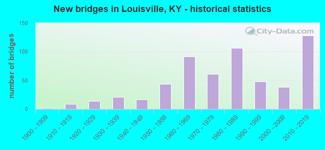
- New bridges - historical statistics
- 21900-1909
- 91910-1919
- 141920-1929
- 211930-1939
- 171940-1949
- 441950-1959
- 921960-1969
- 611970-1979
- 1061980-1989
- 481990-1999
- 382000-2009
- 1282010-2019
- 12020-2022
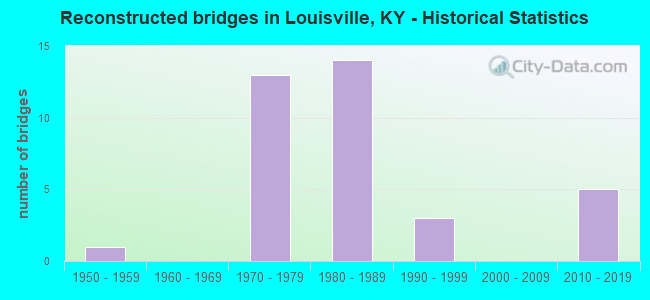
- Reconstructed bridges - Historical Statistics
- 11950-1959
- 01960-1969
- 131970-1979
- 141980-1989
- 31990-1999
- 02000-2009
- 52010-2019
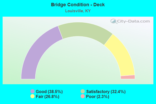
- Bridge Condition - Deck
- 38.5%Good
- 32.4%Satisfactory
- 26.8%Fair
- 2.3%Poor
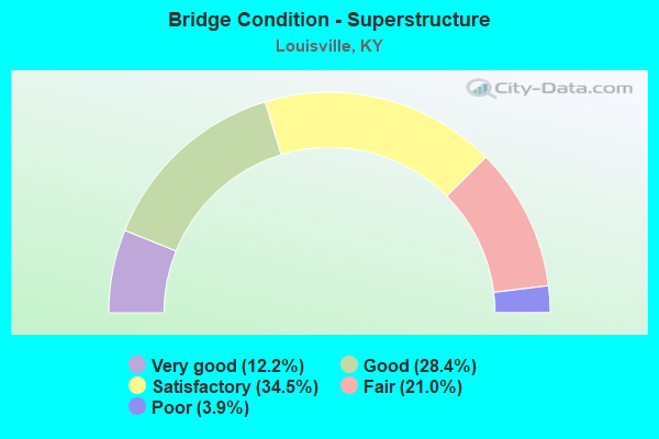
- Bridge Condition - Superstructure
- 12.2%Very good
- 28.4%Good
- 34.5%Satisfactory
- 21.0%Fair
- 3.9%Poor
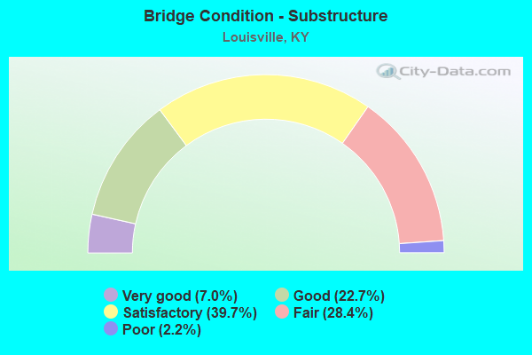
- Bridge Condition - Substructure
- 7.0%Very good
- 22.7%Good
- 39.7%Satisfactory
- 28.4%Fair
- 2.2%Poor
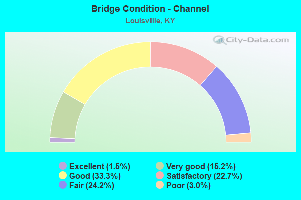
- Bridge Condition - Channel
- 1.5%Excellent
- 15.2%Very good
- 33.3%Good
- 22.7%Satisfactory
- 24.2%Fair
- 3.0%Poor
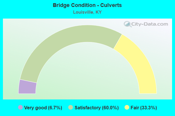
- Bridge Condition - Culverts
- 6.7%Very good
- 60.0%Satisfactory
- 33.3%Fair
Find on map >> Show street view
Structure Number: 56T00930N, Location: 0.65 MI W OF US 42 WB (Lat: 38.260278, Lng: -85.736667), Route carried "on" structure: Ramp Interstate 64, Year Built: 2016, Status: Open, Structure Length: 33.12m (108.66ft), Average Daily Traffic: 77,250 (year 2018), Truck Traffic: 11%, Average Future Daily Traffic: 95,978 (year 2038), Design Load: Greater than HL93, Features Intersected: WTHRSPN, CSX RR & RAMPS
Minimum Vertical Clearance: 30+ m (98+ ft), Kilometerpoint: 0.808, Lanes on structure: 2, Lanes under structure: 7, Owner: State Highway Agency, Approaching Roadway Width: 13.4m (44.0ft), Material/Design: Steel continuous, Design/Construction: Stringer/Multi-beam, Number Of Spans In Main Unit: 7, Length of Maximum Span: 66.7m (218.8ft), Curb-To-Curb Width: 13.4m (44.0ft), Out-to-Out Width: 14.4m (47.2ft)
Condition: Deck: Good, Superstructure: Good, Substructure: Good, Operating Rating: 63.8 metric tons, Method Used To Determine Operating Rating: Load and Resistance Factor Rating (LRFR) rating reported by rating factor(RF) method using HL-93 loadings, Inventory Rating: 49.2 metric tons, Method Used To Determine Inventory Rating: Load and Resistance Factor Rating (LRFR) rating reported by rating factor(RF) method using HL-93 loadings, Structural Evaluation: Better than present minimum criteria, Deck Geometry: Superior to present desirable criteria, Underclear: Equal to present minimum criteria, Approach Roadway Alignment: Equal to present desirable criteria, Designated Inspection Frequency: Every 24 months, Inspection Date: November 2020, Deck Structure Type: Concrete Cast-file-Place, Wearing Surface/Protective System: Wearing Surface: Monolithic Concrete, Deck Protection: Epoxy Coated Reinforcing
Find on map >> Show street view
Structure Number: 56T00931N, Location: 0.3 MI E OF I-65 NB (Lat: 38.260556, Lng: -85.736389), Route carried "on" structure: Interstate 64, Year Built: 2016, Status: Open, Structure Length: 4.88m (16.01ft), Average Daily Traffic: 144,000 (year 2008), Truck Traffic: 11%, Average Future Daily Traffic: 165,600 (year 2028), Design Load: Greater than HL93, Features Intersected: WITHERSPOON & CSX RR
Minimum Vertical Clearance: 30+ m (98+ ft), Kilometerpoint: 9.286, Lanes on structure: 3, Lanes under structure: 2, Base Highway Network: Yes, Owner: State Highway Agency, Approaching Roadway Width: 27.0m (88.6ft), Skew: 32 degrees, Material/Design: Prestressed concrete continuous, Design/Construction: Stringer/Multi-beam, Number Of Spans In Main Unit: 2, Length of Maximum Span: 27.4m (89.9ft), Curb-To-Curb Width: 27.0m (88.6ft), Out-to-Out Width: 28.9m (94.8ft)
Condition: Deck: Good, Superstructure: Very good, Substructure: Satisfactory, Operating Rating: 50.5 metric tons, Method Used To Determine Operating Rating: Load and Resistance Factor Rating (LRFR) rating reported by rating factor(RF) method using HL-93 loadings, Inventory Rating: 38.9 metric tons, Method Used To Determine Inventory Rating: Load and Resistance Factor Rating (LRFR) rating reported by rating factor(RF) method using HL-93 loadings, Structural Evaluation: Equal to present minimum criteria, Deck Geometry: Superior to present desirable criteria, Underclear: Somewhat better than minimum adequacy, Approach Roadway Alignment: Equal to present desirable criteria, Designated Inspection Frequency: Every 24 months, Inspection Date: November 2020, Deck Structure Type: Concrete Cast-file-Place, Wearing Surface/Protective System: Wearing Surface: Monolithic Concrete, Deck Protection: Epoxy Coated Reinforcing
Find on map >> Show street view
Structure Number: 56T00932N, Location: 0.23 MI E OF I-65 (Lat: 38.260750, Lng: -85.736389), Route carried "on" structure: Ramp Interstate 64, Year Built: 2016, Status: Open, Structure Length: 4.40m (14.44ft), Average Daily Traffic: 148,536 (year 2018), Average Future Daily Traffic: 181,213 (year 2038), Design Load: Greater than HL93, Features Intersected: WITHERSPOON & CSX RR
Minimum Vertical Clearance: 30+ m (98+ ft), Kilometerpoint: 1.220, Lanes on structure: 2, Lanes under structure: 2, Owner: State Highway Agency, Approaching Roadway Width: 13.4m (44.0ft), Skew: 1 degrees, Material/Design: Prestressed concrete continuous, Design/Construction: Stringer/Multi-beam, Number Of Spans In Main Unit: 2, Length of Maximum Span: 24.1m (79.1ft), Curb-To-Curb Width: 13.4m (44.0ft), Out-to-Out Width: 14.3m (46.9ft)
Condition: Deck: Good, Superstructure: Very good, Substructure: Satisfactory, Operating Rating: 80.0 metric tons, Method Used To Determine Operating Rating: Load and Resistance Factor Rating (LRFR) rating reported by rating factor(RF) method using HL-93 loadings, Inventory Rating: 61.6 metric tons, Method Used To Determine Inventory Rating: Load and Resistance Factor Rating (LRFR) rating reported by rating factor(RF) method using HL-93 loadings, Structural Evaluation: Equal to present minimum criteria, Deck Geometry: Superior to present desirable criteria, Underclear: Somewhat better than minimum adequacy, Approach Roadway Alignment: Equal to present desirable criteria, Designated Inspection Frequency: Every 24 months, Inspection Date: November 2020, Deck Structure Type: Concrete Cast-file-Place, Wearing Surface/Protective System: Wearing Surface: Monolithic Concrete, Deck Protection: Epoxy Coated Reinforcing
Find on map >> Show street view
Structure Number: 56T00933N, Location: 0.85 MI W OF US 42 WB (Lat: 38.260981, Lng: -85.736511), Route carried "on" structure: Interstate 64, Year Built: 2016, Status: Open, Structure Length: 5.93m (19.46ft), Average Daily Traffic: 144,000 (year 2008), Truck Traffic: 11%, Average Future Daily Traffic: 165,600 (year 2028), Design Load: Greater than HL93, Features Intersected: WITHERSPOON & CSX RR
Minimum Vertical Clearance: 30+ m (98+ ft), Kilometerpoint: 9.291, Lanes on structure: 6, Lanes under structure: 2, Base Highway Network: Yes, Owner: State Highway Agency, Approaching Roadway Width: 39.0m (128.0ft), Skew: 32 degrees, Material/Design: Prestressed concrete continuous, Design/Construction: Stringer/Multi-beam, Number Of Spans In Main Unit: 2, Length of Maximum Span: 29.3m (96.1ft), Curb-To-Curb Width: 39.0m (128.0ft), Out-to-Out Width: 40.8m (133.9ft)
Condition: Deck: Good, Superstructure: Very good, Substructure: Good, Operating Rating: 49.9 metric tons, Method Used To Determine Operating Rating: Load and Resistance Factor Rating (LRFR) rating reported by rating factor(RF) method using HL-93 loadings, Inventory Rating: 38.6 metric tons, Method Used To Determine Inventory Rating: Load and Resistance Factor Rating (LRFR) rating reported by rating factor(RF) method using HL-93 loadings, Structural Evaluation: Better than present minimum criteria, Deck Geometry: Superior to present desirable criteria, Underclear: Equal to present desirable criteria, Approach Roadway Alignment: Equal to present desirable criteria, Designated Inspection Frequency: Every 24 months, Inspection Date: November 2020, Deck Structure Type: Concrete Cast-file-Place, Wearing Surface/Protective System: Wearing Surface: Monolithic Concrete, Deck Protection: Epoxy Coated Reinforcing
Find on map >> Show street view
Structure Number: 56T00934N, Location: 0.7 MI E OF I-65 NTRCH (Lat: 38.261361, Lng: -85.727422), Route carried "on" structure: Ramp Interstate 64, Year Built: 2016, Status: Open, Structure Length: 27.57m (90.45ft), Average Daily Traffic: 14,490 (year 2013), Truck Traffic: 11%, Average Future Daily Traffic: 16,663 (year 2033), Design Load: Greater than HL93, Features Intersected: I-64 & RAMPS
Minimum Vertical Clearance: 30+ m (98+ ft), Kilometerpoint: 0.797, Lanes on structure: 2, Lanes under structure: 9, Owner: State Highway Agency, Approaching Roadway Width: 17.1m (56.1ft), Skew: 5 degrees, Material/Design: Steel continuous, Design/Construction: Stringer/Multi-beam, Number Of Spans In Main Unit: 8, Length of Maximum Span: 49.4m (162.1ft), Curb-To-Curb Width: 17.1m (56.1ft), Out-to-Out Width: 18.1m (59.4ft)
Condition: Deck: Good, Superstructure: Good, Substructure: Very good, Operating Rating: 43.4 metric tons, Method Used To Determine Operating Rating: Load and Resistance Factor Rating (LRFR) rating reported by rating factor(RF) method using HL-93 loadings, Inventory Rating: 33.4 metric tons, Method Used To Determine Inventory Rating: Load and Resistance Factor Rating (LRFR) rating reported by rating factor(RF) method using HL-93 loadings, Structural Evaluation: Better than present minimum criteria, Deck Geometry: Superior to present desirable criteria, Underclear: Equal to present minimum criteria, Approach Roadway Alignment: Equal to present desirable criteria, Designated Inspection Frequency: Every 24 months, Inspection Date: October 2020, Deck Structure Type: Concrete Cast-file-Place, Wearing Surface/Protective System: Wearing Surface: Epoxy Overlay, Deck Protection: Epoxy Coated Reinforcing
Find on map >> Show street view
Structure Number: 56T00935N, Location: 1.85 MI S OF ZORN NTRCH (Lat: 38.261667, Lng: -85.726944), Route carried "on" structure: Ramp Interstate 65, Year Built: 2016, Status: Open, Structure Length: 9.22m (30.25ft), Average Daily Traffic: 85,117 (year 2018), Average Future Daily Traffic: 103,842 (year 2038), Design Load: Greater than HL93, Features Intersected: I-64 WB
Minimum Vertical Clearance: 30+ m (98+ ft), Kilometerpoint: 0.220, Lanes on structure: 2, Lanes under structure: 2, Owner: State Highway Agency, Approaching Roadway Width: 14.3m (46.9ft), Skew: 5 degrees, Material/Design: Prestressed concrete continuous, Design/Construction: Stringer/Multi-beam, Number Of Spans In Main Unit: 3, Length of Maximum Span: 34.9m (114.5ft), Curb-To-Curb Width: 14.3m (46.9ft), Out-to-Out Width: 15.3m (50.2ft)
Condition: Deck: Good, Superstructure: Good, Substructure: Good, Operating Rating: 64.2 metric tons, Method Used To Determine Operating Rating: Load and Resistance Factor Rating (LRFR) rating reported by rating factor(RF) method using HL-93 loadings, Inventory Rating: 49.6 metric tons, Method Used To Determine Inventory Rating: Load and Resistance Factor Rating (LRFR) rating reported by rating factor(RF) method using HL-93 loadings, Structural Evaluation: Better than present minimum criteria, Deck Geometry: Superior to present desirable criteria, Underclear: Equal to present minimum criteria, Approach Roadway Alignment: Equal to present desirable criteria, Designated Inspection Frequency: Every 24 months, Inspection Date: October 2020, Deck Structure Type: Concrete Cast-file-Place, Wearing Surface/Protective System: Wearing Surface: Monolithic Concrete, Deck Protection: Epoxy Coated Reinforcing
Find on map >> Show street view
Structure Number: 56T00937N, Location: 0.2 MI W OF US 42 WB (Lat: 38.260833, Lng: -85.724722), Route carried "on" structure: Ramp Interstate 64, Year Built: 2016, Status: Open, Structure Length: 29.18m (95.73ft), Average Daily Traffic: 18,650 (year 2018), Average Future Daily Traffic: 21,448 (year 2038), Design Load: Greater than HL93, Features Intersected: I-64 WB
Minimum Vertical Clearance: 30+ m (98+ ft), Kilometerpoint: 0.262, Lanes on structure: 1, Lanes under structure: 3, Owner: State Highway Agency, Approaching Roadway Width: 9.4m (30.8ft), Skew: 9 degrees, Material/Design: Steel continuous, Design/Construction: Stringer/Multi-beam, Number Of Spans In Main Unit: 8, Length of Maximum Span: 51.5m (169.0ft), Curb-To-Curb Width: 9.4m (30.8ft), Out-to-Out Width: 10.5m (34.4ft)
Condition: Deck: Satisfactory, Superstructure: Good, Substructure: Good, Operating Rating: 52.2 metric tons, Method Used To Determine Operating Rating: Load and Resistance Factor Rating (LRFR) rating reported by rating factor(RF) method using HL-93 loadings, Inventory Rating: 40.2 metric tons, Method Used To Determine Inventory Rating: Load and Resistance Factor Rating (LRFR) rating reported by rating factor(RF) method using HL-93 loadings, Structural Evaluation: Better than present minimum criteria, Deck Geometry: Superior to present desirable criteria, Underclear: Equal to present minimum criteria, Approach Roadway Alignment: Equal to present desirable criteria, Designated Inspection Frequency: Every 24 months, Inspection Date: October 2020, Deck Structure Type: Concrete Cast-file-Place, Wearing Surface/Protective System: Wearing Surface: Monolithic Concrete, Deck Protection: Epoxy Coated Reinforcing
Find on map >> Show street view
Structure Number: 56T00938L, Location: 0.16 MI W OF US 42 EB (Lat: 38.258333, Lng: -85.722778), Route carried "on" structure: Interstate 64, Year Built: 1968, Year Reconstructed: 2016, Status: Open, Structure Length: 2.07m (6.79ft), Average Daily Traffic: 37,300 (year 2011), Truck Traffic: 8%, Average Future Daily Traffic: 39,911 (year 2031), Design Load: HS 20, Features Intersected: US 42 WB
Minimum Vertical Clearance: 30+ m (98+ ft), Kilometerpoint: 10.593, Lanes on structure: 2, Lanes under structure: 3, Base Highway Network: Yes, Owner: State Highway Agency, Approaching Roadway Width: 17.3m (56.8ft), Material/Design: Steel, Design/Construction: Stringer/Multi-beam, Number Of Spans In Main Unit: 1, Length of Maximum Span: 19.0m (62.3ft), Curb-To-Curb Width: 17.3m (56.8ft), Out-to-Out Width: 18.4m (60.4ft)
Condition: Deck: Satisfactory, Superstructure: Satisfactory, Substructure: Satisfactory, Operating Rating: 79.7 metric tons, Method Used To Determine Operating Rating: Load and Resistance Factor Rating (LRFR) rating reported by rating factor(RF) method using HL-93 loadings, Inventory Rating: 61.6 metric tons, Method Used To Determine Inventory Rating: Load and Resistance Factor Rating (LRFR) rating reported by rating factor(RF) method using HL-93 loadings, Structural Evaluation: Equal to present minimum criteria, Deck Geometry: Superior to present desirable criteria, Underclear: Somewhat better than minimum adequacy, Approach Roadway Alignment: Equal to present desirable criteria, Length Of Structure Improvement: 0.20m (0.66ft), Designated Inspection Frequency: Every 24 months, Inspection Date: October 2020, Bridge Improvement Cost: $268,000, Total Project Cost: $268,000, Deck Structure Type: Concrete Cast-file-Place, Wearing Surface/Protective System: Wearing Surface: Latex Concrete, Deck Protection: Epoxy Coated Reinforcing
Find on map >> Show street view
Structure Number: 56T00939L, Location: 0.12 MI E OF US 42 WB (Lat: 38.256667, Lng: -85.721667), Route carried "on" structure: Interstate 64, Year Built: 1968, Year Reconstructed: 2016, Status: Open, Structure Length: 15.69m (51.48ft), Average Daily Traffic: 37,300 (year 2011), Truck Traffic: 8%, Average Future Daily Traffic: 39,911 (year 2031), Design Load: HS 20, Features Intersected: US 42 EB & BEARGRASS CRK
Minimum Vertical Clearance: 30+ m (98+ ft), Kilometerpoint: 10.784, Lanes on structure: 2, Lanes under structure: 3, Base Highway Network: Yes, Owner: State Highway Agency, Approaching Roadway Width: 17.4m (57.1ft), Skew: 1 degrees, Material/Design: Steel continuous, Design/Construction: Stringer/Multi-beam, Number Of Spans In Main Unit: 6, Length of Maximum Span: 34.7m (113.8ft), Curb-To-Curb Width: 17.4m (57.1ft), Out-to-Out Width: 18.4m (60.4ft)
Condition: Deck: Fair, Superstructure: Satisfactory, Substructure: Fair, Channel: Good, Operating Rating: 40.8 metric tons, Method Used To Determine Operating Rating: Load and Resistance Factor Rating (LRFR) rating reported by rating factor(RF) method using HL-93 loadings, Inventory Rating: 31.4 metric tons, Method Used To Determine Inventory Rating: Load and Resistance Factor Rating (LRFR) rating reported by rating factor(RF) method using HL-93 loadings, Structural Evaluation: Somewhat better than minimum adequacy, Deck Geometry: Superior to present desirable criteria, Underclear: Somewhat better than minimum adequacy, Waterway Adequacy: Equal to present desirable criteria, Approach Roadway Alignment: Equal to present desirable criteria, Designated Inspection Frequency: Every 24 months, Inspection Date: October 2020, Deck Structure Type: Concrete Cast-file-Place, Wearing Surface/Protective System: Wearing Surface: Latex Concrete
Find on map >> Show street view
Structure Number: 56T00940N, Location: 0.15 MI N OF I-64 OP (Lat: 38.262222, Lng: -85.724167), Route carried "on" structure: Interstate 71, Year Built: 2016, Status: Open, Structure Length: 4.11m (13.48ft), Average Daily Traffic: 57,871 (year 2016), Truck Traffic: 12%, Average Future Daily Traffic: 66,551 (year 2036), Design Load: Greater than HL93, Features Intersected: FRANKFORT AVE
Minimum Vertical Clearance: 30+ m (98+ ft), Kilometerpoint: 0.026, Lanes on structure: 4, Lanes under structure: 1, Base Highway Network: Yes, Owner: State Highway Agency, Approaching Roadway Width: 36.6m (120.1ft), Skew: 31 degrees, Material/Design: Prestressed concrete, Design/Construction: Stringer/Multi-beam, Number Of Spans In Main Unit: 1, Length of Maximum Span: 40.1m (131.6ft), Curb-To-Curb Width: 36.6m (120.1ft), Out-to-Out Width: 38.3m (125.7ft)
Condition: Deck: Good, Superstructure: Good, Substructure: Good, Operating Rating: 97.2 metric tons, Method Used To Determine Operating Rating: Load and Resistance Factor Rating (LRFR) rating reported by rating factor(RF) method using HL-93 loadings, Inventory Rating: 89.4 metric tons, Method Used To Determine Inventory Rating: Load and Resistance Factor Rating (LRFR) rating reported by rating factor(RF) method using HL-93 loadings, Structural Evaluation: Better than present minimum criteria, Deck Geometry: Superior to present desirable criteria, Underclear: Equal to present minimum criteria, Approach Roadway Alignment: Equal to present desirable criteria, Designated Inspection Frequency: Every 24 months, Inspection Date: October 2020, Deck Structure Type: Concrete Cast-file-Place, Wearing Surface/Protective System: Wearing Surface: Monolithic Concrete, Deck Protection: Epoxy Coated Reinforcing
Find on map >> Show street view
Structure Number: CEPLRLKY0002009, Location: McAlpine Locks (Lat: 38.277853, Lng: -85.790811), Route carried "on" structure: ServiceFederal lands road , Year Built: 2009, Status: Posted for load-capacity, Structure Length: 53.55m (175.69ft), Average Daily Traffic: 250 (year 2002), Truck Traffic: 25%, Average Future Daily Traffic: 250 (year 2038), Design Load: HS 25 or greater, Features Intersected: Ohio River, Facility Carried by Structure: N 27th Street
Minimum Vertical Clearance: 7.46m (24.48ft), Kilometerpoint: 0.000, Lanes on structure: 2, Owner: Corps of Engineers (Civil), Approaching Roadway Width: 7.3m (24.0ft), Skew: 9 degrees, Navigation Control: Yes ( Vertical Clearance: 22.7m (74.5ft), Horizontal Clearance: 33.5m (109.9ft)), Material/Design: Prestressed concrete continuous, Design/Construction: Stringer/Multi-beam, Number Of Spans In Main Unit: 20, Length of Maximum Span: 40.3m (132.2ft), Curb or Sidewalk Widths: Left: 1.4m (4.6ft), Right: 0.0m, Curb-To-Curb Width: 7.3m (24.0ft), Out-to-Out Width: 9.5m (31.2ft)
Condition: Deck: Good, Superstructure: Good, Substructure: Good, Channel: Very good, Operating Rating: 55.6 metric tons, Method Used To Determine Operating Rating: Load and Resistance Factor (LRFR), Inventory Rating: 32.4 metric tons, Method Used To Determine Inventory Rating: Load and Resistance Factor (LRFR), Structural Evaluation: Better than present minimum criteria, Deck Geometry: Somewhat better than minimum adequacy, Waterway Adequacy: Superior to present desirable criteria, Approach Roadway Alignment: Equal to present desirable criteria, Length Of Structure Improvement: 1.21m (3.97ft), Designated Inspection Frequency: Every 24 months, Inspection Date: July 2021, Bridge Improvement Cost: $40,000, Total Project Cost: $40,000 ( Estimate for 2021), Deck Structure Type: Concrete Cast-file-Place
Find on map >> Show street view
Structure Number: 56B00063L, Location: 0.3 MI N OF ZORN AV NTRCH (Lat: 38.276944, Lng: -85.694167), Route carried "under" structure: Bypass County highway 1004, Year Built: 1967, Structure Length: 0. m, Average Daily Traffic: 1,248 (year 2018), Features Intersected: MOCKINGBIRD VALLEY RD, Facility Carried by Structure: I-71 SB
Minimum Vertical Clearance: 6.76m (22.18ft), Kilometerpoint: 2.395, Lanes on structure: 2, Lanes under structure: 2, Material/Design: Concrete, Design/Construction: Tee Beam, Length of Maximum Span: 15.2m (49.9ft)
Find on map >> Show street view
Structure Number: 56B00063R, Location: 0.3 MI N OF ZORN AV NTRCH (Lat: 38.276667, Lng: -85.694167), Route carried "under" structure: Bypass County highway 1004, Year Built: 1967, Structure Length: 0. m, Average Daily Traffic: 1,248 (year 2018), Features Intersected: MOCKINGBIRD VALLEY RD, Facility Carried by Structure: I-71 NB
Minimum Vertical Clearance: 6.81m (22.34ft), Kilometerpoint: 2.367, Lanes on structure: 2, Lanes under structure: 2, Material/Design: Concrete, Design/Construction: Tee Beam, Length of Maximum Span: 15.2m (49.9ft)
Find on map >> Show street view
Structure Number: 56B00136N, Location: AT KY/IN STATE LINE (Lat: 38.263611, Lng: -85.751667), Route carried "under" structure: Interstate 64, Year Built: 1929, Structure Length: 0. m, Average Daily Traffic: 90,900 (year 2010), Truck Traffic: 9%, Features Intersected: OHIO RIVER, Facility Carried by Structure: US 31 (2ND ST)
Minimum Vertical Clearance: 6.86m (22.51ft), Kilometerpoint: 7.673, Lanes on structure: 4, Lanes under structure: 6, Material/Design: Steel continuous, Design/Construction: Truss - Thru, Length of Maximum Span: 249.9m (819.9ft)
Find on map >> Show street view
Structure Number: 56B00136N, Location: AT KY/IN STATE LINE (Lat: 38.263611, Lng: -85.751667), Route carried "under" structure: State highway 3077, Year Built: 1929, Structure Length: 0. m, Average Daily Traffic: 4,039 (year 2020), Truck Traffic: 6%, Features Intersected: OHIO RIVER, Facility Carried by Structure: US 31 (2ND ST)
Minimum Vertical Clearance: 7.62m (25.00ft), Kilometerpoint: 0.756, Lanes on structure: 4, Lanes under structure: 2, Material/Design: Steel continuous, Design/Construction: Truss - Thru, Length of Maximum Span: 249.9m (819.9ft)
Find on map >> Show street view
Structure Number: 56B00136N, Location: AT KY/IN STATE LINE (Lat: 38.263611, Lng: -85.751667), Route carried "under" structure: Ramp Interstate 64, Year Built: 1929, Structure Length: 0. m, Average Daily Traffic: 90,900 (year 2010), Truck Traffic: 9%, Features Intersected: OHIO RIVER, Facility Carried by Structure: US 31 (2ND ST)
Minimum Vertical Clearance: 7.62m (25.00ft), Kilometerpoint: 7.681, Lanes on structure: 4, Lanes under structure: 1, Material/Design: Steel continuous, Design/Construction: Truss - Thru, Length of Maximum Span: 249.9m (819.9ft)
Find on map >> Show street view
Structure Number: 56B00138N, Location: 0.4 MI E OF S 3RD STREET (Lat: 38.213333, Lng: -85.756667), Route carried "under" structure: City street 2250, Year Built: 1954, Structure Length: 0. m, Features Intersected: CSX RR, FLOYD & BROOK ST, Facility Carried by Structure: US 60A (EASTERN)
Minimum Vertical Clearance: 2.67m (8.76ft), Kilometerpoint: 0.084, Lanes on structure: 2, Lanes under structure: 2, Material/Design: Concrete continuous, Design/Construction: Tee Beam, Length of Maximum Span: 24.4m (80.1ft)
Find on map >> Show street view
Structure Number: 56B00138N, Location: 0.4 MI E OF S 3RD STREET (Lat: 38.213333, Lng: -85.756667), Route carried "under" structure: City street 1003, Year Built: 1954, Structure Length: 0. m, Average Daily Traffic: 11,058 (year 2020), Features Intersected: CSX RR, FLOYD & BROOK ST, Facility Carried by Structure: US 60A (EASTERN)
Minimum Vertical Clearance: 5.13m (16.83ft), Kilometerpoint: 4.723, Lanes on structure: 2, Lanes under structure: 2, Material/Design: Concrete continuous, Design/Construction: Tee Beam, Length of Maximum Span: 24.4m (80.1ft)
Find on map >> Show street view
Structure Number: 56B00138N, Location: 0.4 MI E OF S 3RD STREET (Lat: 38.213333, Lng: -85.756667), Route carried "under" structure: City street 1006, Year Built: 1954, Structure Length: 0. m, Average Daily Traffic: 2,681 (year 2013), Features Intersected: CSX RR, FLOYD & BROOK ST, Facility Carried by Structure: US 60A (EASTERN)
Minimum Vertical Clearance: 6.60m (21.65ft), Kilometerpoint: 4.062, Lanes on structure: 2, Lanes under structure: 2, Material/Design: Concrete continuous, Design/Construction: Tee Beam, Length of Maximum Span: 24.4m (80.1ft)
Find on map >> Show street view
Structure Number: 56B00141R, Location: 0.15 MI E OF STORY AVE (Lat: 38.256667, Lng: -85.721667), Route carried "under" structure: US 42, Year Built: 1968, Structure Length: 0. m, Average Daily Traffic: 13,359 (year 2020), Truck Traffic: 25%, Features Intersected: US 42 EB & BEARGRASS CRK, Facility Carried by Structure: I-64 EB
Minimum Vertical Clearance: 4.72m (15.49ft), Kilometerpoint: 1.056, Lanes on structure: 2, Lanes under structure: 3, Material/Design: Steel continuous, Design/Construction: Stringer/Multi-beam, Length of Maximum Span: 34.7m (113.8ft)
Find on map >> Show street view
Structure Number: 56B00142N, Location: 1.0 MI E OF US 31W NTRCH (Lat: 38.258889, Lng: -85.748889), Route carried "under" structure: Bypass City street 1001, Year Built: 1965, Structure Length: 0. m, Average Daily Traffic: 6,987 (year 2020), Features Intersected: KY 3077 (RIVER RD), Facility Carried by Structure: I-64
Minimum Vertical Clearance: 7.62m (25.00ft), Kilometerpoint: 0.089, Lanes on structure: 6, Lanes under structure: 4, Material/Design: Steel, Design/Construction: Stringer/Multi-beam, Length of Maximum Span: 32.9m (107.9ft)
Find on map >> Show street view
Structure Number: 56B00143L, Location: 0.3 MI W OF KY 2048 NTRCH (Lat: 38.237778, Lng: -85.664722), Route carried "under" structure: City street 1144, Year Built: 1969, Structure Length: 0. m, Average Daily Traffic: 1,402 (year 2009), Features Intersected: OLD CANNONS LN, Facility Carried by Structure: I-64 WB
Minimum Vertical Clearance: 5.36m (17.59ft), Kilometerpoint: 0.592, Lanes on structure: 2, Lanes under structure: 2, Material/Design: Concrete, Design/Construction: Frame, Length of Maximum Span: 17.1m (56.1ft)
Find on map >> Show street view
Structure Number: 56B00143R, Location: 0.3 MI W OF KY 2048 NTRCH (Lat: 38.237778, Lng: -85.664444), Route carried "under" structure: City street 1144, Year Built: 1969, Structure Length: 0. m, Average Daily Traffic: 1,402 (year 2009), Features Intersected: OLD CANNONS LN, Facility Carried by Structure: I-64 EB
Minimum Vertical Clearance: 5.28m (17.32ft), Kilometerpoint: 0.616, Lanes on structure: 2, Lanes under structure: 2, Material/Design: Concrete, Design/Construction: Frame, Length of Maximum Span: 17.3m (56.8ft)
Find on map >> Show street view
Structure Number: 56B00144N, Location: 0.75 MI S OF KY 2048 (Lat: 38.239444, Lng: -85.675556), Route carried "under" structure: Interstate 64, Year Built: 1970, Structure Length: 0. m, Average Daily Traffic: 82,552 (year 2018), Truck Traffic: 8%, Features Intersected: I-64, Facility Carried by Structure: PEE WEE REESE RD
Minimum Vertical Clearance: 5.11m (16.77ft), Kilometerpoint: 15.429, Lanes on structure: 2, Lanes under structure: 4, Material/Design: Concrete, Design/Construction: Frame, Length of Maximum Span: 19.1m (62.7ft)
Find on map >> Show street view
Structure Number: 56B00145N, Location: 1.0 MI W OF KY 2048 NTRCH (Lat: 38.240278, Lng: -85.677778), Route carried "under" structure: Interstate 64, Year Built: 1970, Structure Length: 0. m, Average Daily Traffic: 82,552 (year 2018), Truck Traffic: 8%, Features Intersected: I-64, Facility Carried by Structure: BRIDLE PATH
Minimum Vertical Clearance: 6.07m (19.91ft), Kilometerpoint: 15.208, Lanes under structure: 4, Material/Design: Steel, Design/Construction: Frame, Length of Maximum Span: 24.4m (80.1ft)
Find on map >> Show street view
Structure Number: 56B00146L, Location: 0.25 MI S OF US 60A (Lat: 38.242222, Lng: -85.687500), Route carried "under" structure: Interstate 64, Year Built: 1970, Structure Length: 0. m, Average Daily Traffic: 82,552 (year 2018), Truck Traffic: 8%, Features Intersected: I-64 WB, Facility Carried by Structure: ALTA VISTA RD
Minimum Vertical Clearance: 6.68m (21.92ft), Kilometerpoint: 14.339, Lanes on structure: 2, Lanes under structure: 4, Material/Design: Concrete, Design/Construction: Frame, Length of Maximum Span: 19.7m (64.6ft)
Find on map >> Show street view
Structure Number: 56B00146R, Location: 0.25 MI S OF US 60A (Lat: 38.241944, Lng: -85.687500), Route carried "under" structure: Interstate 64, Year Built: 1970, Structure Length: 0. m, Average Daily Traffic: 82,552 (year 2018), Truck Traffic: 8%, Features Intersected: I-64 EB, Facility Carried by Structure: ALTA VISTA RD
Minimum Vertical Clearance: 6.25m (20.51ft), Kilometerpoint: 14.339, Lanes on structure: 2, Lanes under structure: 4, Material/Design: Concrete, Design/Construction: Frame, Length of Maximum Span: 19.6m (64.3ft)
Find on map >> Show street view
Structure Number: 56B00147L, Location: 2.0 MI E OF CANNONS LN (Lat: 38.242500, Lng: -85.694167), Route carried "under" structure: City street 1281, Year Built: 1970, Structure Length: 0. m, Average Daily Traffic: 130 (year 2006), Features Intersected: BEALS BRANCH RD, Facility Carried by Structure: I-64 WB
Minimum Vertical Clearance: 7.44m (24.41ft), Kilometerpoint: 0.163, Lanes on structure: 2, Lanes under structure: 2, Material/Design: Concrete, Design/Construction: Frame, Length of Maximum Span: 19.5m (64.0ft)
Find on map >> Show street view
Structure Number: 56B00147R, Location: 2.0 MI E OF CANNONS LN (Lat: 38.242222, Lng: -85.694444), Route carried "under" structure: City street 1281, Year Built: 1970, Structure Length: 0. m, Average Daily Traffic: 130 (year 2006), Features Intersected: BEALS BRANCH RD, Facility Carried by Structure: I-64 EB
Minimum Vertical Clearance: 7.62m (25.00ft), Kilometerpoint: 0.129, Lanes on structure: 2, Lanes under structure: 2, Material/Design: Concrete, Design/Construction: Frame, Length of Maximum Span: 19.5m (64.0ft)
Find on map >> Show street view
Structure Number: 56B00148L, Location: 1.6 MI E OF US 42 NTRCH (Lat: 38.245000, Lng: -85.697500), Route carried "under" structure: Alternate US 60, Year Built: 1970, Structure Length: 0. m, Average Daily Traffic: 13,027 (year 2020), Truck Traffic: 3%, Features Intersected: US 60A (LEXINGTON RD), Facility Carried by Structure: I-64 WB
Minimum Vertical Clearance: 4.70m (15.42ft), Kilometerpoint: 13.258, Lanes on structure: 2, Lanes under structure: 2, Material/Design: Concrete, Design/Construction: Box Beam or Girders - Single/Spread, Length of Maximum Span: 22.9m (75.1ft)
Find on map >> Show street view
Structure Number: 56B00148R, Location: 1.6 MI E OF US 42 NTRCH (Lat: 38.245000, Lng: -85.697778), Route carried "under" structure: Alternate US 60, Year Built: 1970, Structure Length: 0. m, Average Daily Traffic: 14,441 (year 2016), Truck Traffic: 3%, Features Intersected: US 60A (LEXINGTON RD), Facility Carried by Structure: I-64 EB
Minimum Vertical Clearance: 4.98m (16.34ft), Kilometerpoint: 13.230, Lanes on structure: 2, Lanes under structure: 2, Material/Design: Concrete, Design/Construction: Box Beam or Girders - Single/Spread, Length of Maximum Span: 25.1m (82.3ft)
Find on map >> Show street view
Structure Number: 56B00149L, Location: 1.35 MI E OF US 42 NTRCH (Lat: 38.247222, Lng: -85.700278), Route carried "under" structure: City street 1021, Year Built: 1968, Structure Length: 0. m, Average Daily Traffic: 22,225 (year 2020), Features Intersected: GRINSTEAD DR, Facility Carried by Structure: I-64 WB
Minimum Vertical Clearance: 5.05m (16.57ft), Kilometerpoint: 0.369, Lanes on structure: 2, Lanes under structure: 4, Material/Design: Concrete, Design/Construction: Box Beam or Girders - Single/Spread, Length of Maximum Span: 26.1m (85.6ft)
Find on map >> Show street view
Structure Number: 56B00149R, Location: 1.35 MI E OF US 42 NTRCH (Lat: 38.247222, Lng: -85.700556), Route carried "under" structure: City street 1021, Year Built: 1968, Structure Length: 0. m, Average Daily Traffic: 22,225 (year 2020), Features Intersected: GRINSTEAD DR, Facility Carried by Structure: I-64 EB
Minimum Vertical Clearance: 4.75m (15.58ft), Kilometerpoint: 0.348, Lanes on structure: 2, Lanes under structure: 4, Material/Design: Concrete, Design/Construction: Box Beam or Girders - Single/Spread, Length of Maximum Span: 25.5m (83.7ft)
Find on map >> Show street view
Structure Number: 56B00150N, Location: 0.2 MI N OF LEXINGTON RD (Lat: 38.252222, Lng: -85.717778), Route carried "under" structure: Interstate 64, Year Built: 1968, Structure Length: 0. m, Average Daily Traffic: 74,600 (year 2011), Truck Traffic: 8%, Features Intersected: I-64, Facility Carried by Structure: PAYNE ST
Minimum Vertical Clearance: 5.03m (16.50ft), Kilometerpoint: 11.393, Lanes on structure: 2, Lanes under structure: 4, Material/Design: Steel continuous, Design/Construction: Stringer/Multi-beam, Length of Maximum Span: 18.0m (59.1ft)
Find on map >> Show street view
Structure Number: 56B00151R, Location: 0.1 MI W OF US 42 EB NTRC (Lat: 38.258056, Lng: -85.723056), Route carried "under" structure: US 42, Year Built: 1968, Structure Length: 0. m, Average Daily Traffic: 9,715 (year 2020), Truck Traffic: 28%, Features Intersected: US 42 WB (STORY AVE), Facility Carried by Structure: I-64 EB
Minimum Vertical Clearance: 4.78m (15.68ft), Kilometerpoint: 0.925, Lanes on structure: 2, Lanes under structure: 3, Material/Design: Steel, Design/Construction: Stringer/Multi-beam, Length of Maximum Span: 19.0m (62.3ft)
Find on map >> Show street view
Structure Number: 56B00160N, Location: 0.2 MI E OF US 42 EB NTRC (Lat: 38.253611, Lng: -85.719167), Route carried "under" structure: Interstate 64, Year Built: 1968, Structure Length: 0. m, Average Daily Traffic: 74,600 (year 2011), Truck Traffic: 8%, Features Intersected: I-64, Facility Carried by Structure: CSX RAILROAD
Minimum Vertical Clearance: 4.72m (15.49ft), Kilometerpoint: 11.185, Lanes under structure: 4, Material/Design: Steel, Design/Construction: Stringer/Multi-beam, Length of Maximum Span: 23.3m (76.4ft)
Find on map >> Show street view
Structure Number: 56B00166L, Location: 1.75 MI N OF I-64 NTRCH (Lat: 38.266667, Lng: -85.709722), Route carried "under" structure: Bypass City street 1032, Year Built: 1966, Structure Length: 0. m, Average Daily Traffic: 2,776 (year 2009), Features Intersected: EDITH RD, Facility Carried by Structure: I-71 SB
Minimum Vertical Clearance: 4.72m (15.49ft), Kilometerpoint: 0.703, Lanes on structure: 2, Lanes under structure: 1, Material/Design: Concrete continuous, Design/Construction: Tee Beam, Length of Maximum Span: 19.4m (63.6ft)
Find on map >> Show street view
Structure Number: 56B00166R, Location: 1.75 MI N OF I-64 NTRCH (Lat: 38.266667, Lng: -85.709444), Route carried "under" structure: Bypass City street 1032, Year Built: 1966, Structure Length: 0. m, Average Daily Traffic: 2,776 (year 2009), Features Intersected: EDITH RD, Facility Carried by Structure: I-71 NB
Minimum Vertical Clearance: 4.98m (16.34ft), Kilometerpoint: 0.684, Lanes on structure: 2, Lanes under structure: 1, Material/Design: Concrete continuous, Design/Construction: Tee Beam, Length of Maximum Span: 19.4m (63.6ft)
Find on map >> Show street view
Structure Number: 56B00167L, Location: 3.3 MI S OF I-264 (Lat: 38.275000, Lng: -85.697222), Route carried "under" structure: Bypass City street 1004, Year Built: 1967, Structure Length: 0. m, Average Daily Traffic: 15,361 (year 2015), Features Intersected: ZORN AVE, Facility Carried by Structure: I-71 SB
Minimum Vertical Clearance: 5.23m (17.16ft), Kilometerpoint: 2.506, Lanes on structure: 2, Lanes under structure: 4, Material/Design: Steel continuous, Design/Construction: Stringer/Multi-beam, Length of Maximum Span: 36.6m (120.1ft)
Find on map >> Show street view
Structure Number: 56B00167R, Location: 3.3 MI S OF I-264 (Lat: 38.274722, Lng: -85.697222), Route carried "under" structure: Bypass City street 1004, Year Built: 1967, Structure Length: 0. m, Average Daily Traffic: 15,361 (year 2015), Features Intersected: ZORN AVE, Facility Carried by Structure: I-71 NB
Minimum Vertical Clearance: 5.18m (16.99ft), Kilometerpoint: 2.486, Lanes on structure: 2, Lanes under structure: 4, Material/Design: Steel continuous, Design/Construction: Stringer/Multi-beam, Length of Maximum Span: 36.6m (120.1ft)
Find on map >> Show street view
Structure Number: 56B00179N, Location: 1.0 MI N OF US 60A (Lat: 38.226111, Lng: -85.751389), Route carried "under" structure: City street 1008, Year Built: 1957, Structure Length: 0. m, Average Daily Traffic: 2,596 (year 2006), Features Intersected: HILL, CSX RR & BURNETT, Facility Carried by Structure: I-65
Minimum Vertical Clearance: 6.91m (22.67ft), Kilometerpoint: 0.462, Lanes on structure: 6, Lanes under structure: 2, Material/Design: Steel, Design/Construction: Stringer/Multi-beam, Length of Maximum Span: 32.7m (107.3ft)
Find on map >> Show street view
Structure Number: 56B00179N, Location: 1.0 MI N OF US 60A (Lat: 38.226111, Lng: -85.751389), Route carried "under" structure: City street 1259, Year Built: 1957, Structure Length: 0. m, Average Daily Traffic: 8,063 (year 2012), Features Intersected: HILL, CSX RR & BURNETT, Facility Carried by Structure: I-65
Minimum Vertical Clearance: 7.14m (23.43ft), Kilometerpoint: 0.354, Lanes on structure: 6, Lanes under structure: 2, Material/Design: Steel, Design/Construction: Stringer/Multi-beam, Length of Maximum Span: 32.7m (107.3ft)
Find on map >> Show street view
Structure Number: 56B00180N, Location: 2.1 MI N OF I-264 NTRCH (Lat: 38.212222, Lng: -85.752778), Route carried "under" structure: Alternate US 60, Year Built: 1957, Structure Length: 0. m, Average Daily Traffic: 4,079 (year 2017), Truck Traffic: 7%, Features Intersected: US 60A (EASTERN PKWY), Facility Carried by Structure: I-65
Minimum Vertical Clearance: 4.83m (15.85ft), Kilometerpoint: 6.338, Lanes on structure: 6, Lanes under structure: 4, Material/Design: Steel, Design/Construction: Stringer/Multi-beam, Length of Maximum Span: 37.6m (123.4ft)
Find on map >> Show street view
Structure Number: 56B00181N, Location: 0.15 MI N OF US 60A (Lat: 38.214444, Lng: -85.752500), Route carried "under" structure: City street 1233, Year Built: 1957, Structure Length: 0. m, Average Daily Traffic: 12,106 (year 2015), Features Intersected: UNIVERSITY BLVD, Facility Carried by Structure: I-65
Minimum Vertical Clearance: 4.32m (14.17ft), Kilometerpoint: 0.135, Lanes on structure: 6, Lanes under structure: 2, Material/Design: Concrete continuous, Design/Construction: Tee Beam, Length of Maximum Span: 17.7m (58.1ft)
Find on map >> Show street view
Structure Number: 56B00182N, Location: 0.4 MI N OF US 60A (Lat: 38.218333, Lng: -85.752222), Route carried "under" structure: Ramp State highway 61, Year Built: 1957, Structure Length: 0. m, Average Daily Traffic: 6,910 (year 2012), Truck Traffic: 2%, Features Intersected: KY 61 (E BRANDEIS AVE), Facility Carried by Structure: I-65
Minimum Vertical Clearance: 4.27m (14.01ft), Kilometerpoint: 0.064, Lanes on structure: 6, Lanes under structure: 1, Material/Design: Concrete continuous, Design/Construction: Tee Beam, Length of Maximum Span: 17.7m (58.1ft)
Find on map >> Show street view
Structure Number: 56B00183N, Location: 0.5 MI S OF US 150 (Lat: 38.238333, Lng: -85.753056), Route carried "under" structure: City street 1017, Year Built: 1959, Structure Length: 0. m, Average Daily Traffic: 3,514 (year 2012), Features Intersected: E KENTUCKY & S BROOK ST, Facility Carried by Structure: I-65
Minimum Vertical Clearance: 5.03m (16.50ft), Kilometerpoint: 0.153, Lanes on structure: 6, Lanes under structure: 2, Material/Design: Steel, Design/Construction: Stringer/Multi-beam, Length of Maximum Span: 39.8m (130.6ft)
Find on map >> Show street view
Structure Number: 56B00183N, Location: 0.5 MI S OF US 150 (Lat: 38.238333, Lng: -85.753056), Route carried "under" structure: City street 1006, Year Built: 1959, Structure Length: 0. m, Average Daily Traffic: 2,681 (year 2013), Features Intersected: E KENTUCKY & S BROOK ST, Facility Carried by Structure: I-65
Minimum Vertical Clearance: 4.67m (15.32ft), Kilometerpoint: 3.330, Lanes on structure: 6, Lanes under structure: 2, Material/Design: Steel, Design/Construction: Stringer/Multi-beam, Length of Maximum Span: 39.8m (130.6ft)
Find on map >> Show street view
Structure Number: 56B00184N, Location: 0.4 MI S OF E BRECKINRDGE (Lat: 38.236667, Lng: -85.752222), Route carried "under" structure: City street 1022, Year Built: 1960, Structure Length: 0. m, Average Daily Traffic: 6,922 (year 2015), Features Intersected: ST CATHERINE ST, Facility Carried by Structure: I-65
Minimum Vertical Clearance: 4.72m (15.49ft), Kilometerpoint: 1.878, Lanes on structure: 6, Lanes under structure: 4, Material/Design: Steel continuous, Design/Construction: Stringer/Multi-beam, Length of Maximum Span: 22.6m (74.1ft)
Find on map >> Show street view
Structure Number: 56B00185N, Location: 0.7 MI S OF US 150 (Lat: 38.235278, Lng: -85.751389), Route carried "under" structure: City street 1003, Year Built: 1960, Structure Length: 0. m, Average Daily Traffic: 3,989 (year 2020), Features Intersected: S FLOYD ST, Facility Carried by Structure: I-65
Minimum Vertical Clearance: 4.47m (14.67ft), Kilometerpoint: 2.292, Lanes on structure: 6, Lanes under structure: 2, Material/Design: Steel continuous, Design/Construction: Stringer/Multi-beam, Length of Maximum Span: 38.2m (125.3ft)
Find on map >> Show street view
Structure Number: 56B00186N, Location: 0.8 MI S OF US 150 (Lat: 38.234167, Lng: -85.751111), Route carried "under" structure: City street 1016, Year Built: 1960, Structure Length: 0. m, Average Daily Traffic: 8,872 (year 2015), Features Intersected: E OAK ST, Facility Carried by Structure: I-65
Minimum Vertical Clearance: 4.47m (14.67ft), Kilometerpoint: 0.388, Lanes on structure: 6, Lanes under structure: 2, Material/Design: Steel continuous, Design/Construction: Stringer/Multi-beam, Length of Maximum Span: 20.8m (68.2ft)
Find on map >> Show street view
Structure Number: 56B00187N, Location: 1.3 MI N OF US 60A (Lat: 38.231389, Lng: -85.750833), Route carried "under" structure: City street 1115, Year Built: 1960, Structure Length: 0. m, Average Daily Traffic: 130 (year 2006), Features Intersected: E ORMSBY AVE, Facility Carried by Structure: I-65
Minimum Vertical Clearance: 4.60m (15.09ft), Kilometerpoint: 0.430, Lanes on structure: 6, Lanes under structure: 2, Material/Design: Steel continuous, Design/Construction: Stringer/Multi-beam, Length of Maximum Span: 19.4m (63.6ft)
Find on map >> Show street view
Structure Number: 56B00188N, Location: 0.2 MI S OF US 150 (Lat: 38.243056, Lng: -85.752778), Route carried "under" structure: City street 1519, Year Built: 1960, Structure Length: 0. m, Average Daily Traffic: 130 (year 2006), Features Intersected: COLLEGE ST, Facility Carried by Structure: I-65
Minimum Vertical Clearance: 4.78m (15.68ft), Kilometerpoint: 0.404, Lanes on structure: 6, Lanes under structure: 1, Material/Design: Steel continuous, Design/Construction: Stringer/Multi-beam, Length of Maximum Span: 19.4m (63.6ft)
Find on map >> Show street view
Structure Number: 56B00189N, Location: 0.3 MI S OF US 150 (Lat: 38.241389, Lng: -85.753056), Route carried "under" structure: City street 1015, Year Built: 1960, Structure Length: 0. m, Average Daily Traffic: 4,771 (year 2012), Features Intersected: E BRECKINRIDGE ST, Facility Carried by Structure: I-65
Minimum Vertical Clearance: 4.57m (14.99ft), Kilometerpoint: 2.467, Lanes on structure: 6, Lanes under structure: 2, Material/Design: Steel continuous, Design/Construction: Stringer/Multi-beam, Length of Maximum Span: 19.4m (63.6ft)
Find on map >> Show street view
Structure Number: 56B00190N, Location: 0.25 MI N OF ST CATHERINE (Lat: 38.240000, Lng: -85.753056), Route carried "under" structure: City street 1056, Year Built: 1960, Structure Length: 0. m, Average Daily Traffic: 1,558 (year 2006), Features Intersected: CALDWELL ST, Facility Carried by Structure: I-65
Minimum Vertical Clearance: 4.70m (15.42ft), Kilometerpoint: 0.113, Lanes on structure: 6, Lanes under structure: 1, Material/Design: Steel continuous, Design/Construction: Stringer/Multi-beam, Length of Maximum Span: 19.4m (63.6ft)
Find on map >> Show street view
Structure Number: 56B00191N, Location: 0.5 MI S OF US 31E (Lat: 38.246111, Lng: -85.752222), Route carried "under" structure: City street 1127, Year Built: 1960, Structure Length: 0. m, Average Daily Traffic: 17,762 (year 2006), Features Intersected: JACOB, BROADWAY, GRAY ST, Facility Carried by Structure: I-65
Minimum Vertical Clearance: 4.57m (14.99ft), Kilometerpoint: 0.085, Lanes on structure: 6, Lanes under structure: 2, Material/Design: Steel continuous, Design/Construction: Stringer/Multi-beam, Length of Maximum Span: 37.7m (123.7ft)
Find on map >> Show street view
Structure Number: 56B00191N, Location: 0.5 MI S OF US 31E (Lat: 38.246111, Lng: -85.752222), Route carried "under" structure: US 150, Year Built: 1960, Structure Length: 0. m, Average Daily Traffic: 24,457 (year 2017), Truck Traffic: 9%, Features Intersected: JACOB, BROADWAY, GRAY ST, Facility Carried by Structure: I-65
Minimum Vertical Clearance: 4.62m (15.16ft), Kilometerpoint: 4.355, Lanes on structure: 6, Lanes under structure: 6, Material/Design: Steel continuous, Design/Construction: Stringer/Multi-beam, Length of Maximum Span: 37.7m (123.7ft)
Find on map >> Show street view
Structure Number: 56B00191N, Location: 0.5 MI S OF US 31E (Lat: 38.246111, Lng: -85.752222), Route carried "under" structure: City street 1120, Year Built: 1960, Structure Length: 0. m, Average Daily Traffic: 17,762 (year 2006), Features Intersected: JACOB, BROADWAY, GRAY ST, Facility Carried by Structure: I-65
Minimum Vertical Clearance: 4.47m (14.67ft), Kilometerpoint: 1.172, Lanes on structure: 6, Lanes under structure: 1, Material/Design: Steel continuous, Design/Construction: Stringer/Multi-beam, Length of Maximum Span: 37.7m (123.7ft)
Find on map >> Show street view
Structure Number: 56B00192N, Location: 0.18 MI N OF US 150 (Lat: 38.248333, Lng: -85.752222), Route carried "under" structure: City street 1071, Year Built: 1963, Structure Length: 0. m, Average Daily Traffic: 9,713 (year 2013), Features Intersected: E CHESTNUT ST, Facility Carried by Structure: I-65
Minimum Vertical Clearance: 4.80m (15.75ft), Kilometerpoint: 0.066, Lanes on structure: 6, Lanes under structure: 3, Material/Design: Prestressed concrete continuous, Design/Construction: Stringer/Multi-beam, Length of Maximum Span: 19.4m (63.6ft)
Find on map >> Show street view
Structure Number: 56B00193N, Location: 0.15 MI N OF E CHESTNUT (Lat: 38.250278, Lng: -85.751389), Route carried "under" structure: City street 1048, Year Built: 1963, Structure Length: 0. m, Average Daily Traffic: 8,640 (year 2020), Features Intersected: BROOK ST & MUHAMMAD ALI, Facility Carried by Structure: I-65
Minimum Vertical Clearance: 5.72m (18.77ft), Kilometerpoint: 1.550, Lanes on structure: 6, Lanes under structure: 4, Material/Design: Steel, Design/Construction: Stringer/Multi-beam, Length of Maximum Span: 44.0m (144.4ft)
Find on map >> Show street view
Structure Number: 56B00193N, Location: 0.15 MI N OF E CHESTNUT (Lat: 38.250278, Lng: -85.751389), Route carried "under" structure: City street 1006, Year Built: 1963, Structure Length: 0. m, Average Daily Traffic: 14,276 (year 2020), Features Intersected: BROOK ST & MUHAMMAD ALI, Facility Carried by Structure: I-65
Minimum Vertical Clearance: 4.83m (15.85ft), Kilometerpoint: 4.640, Lanes on structure: 6, Lanes under structure: 4, Material/Design: Steel, Design/Construction: Stringer/Multi-beam, Length of Maximum Span: 44.0m (144.4ft)
Find on map >> Show street view
Structure Number: 56B00194N, Location: 0.1 MI S OF 1ST ST (Lat: 38.250556, Lng: -85.751944), Route carried "under" structure: City street 1048, Year Built: 1963, Structure Length: 0. m, Average Daily Traffic: 8,640 (year 2020), Features Intersected: E MUHAMMAD ALI BLVD, Facility Carried by Structure: I-65 SB ON RAMP
Minimum Vertical Clearance: 5.08m (16.67ft), Kilometerpoint: 1.617, Lanes on structure: 1, Lanes under structure: 4, Material/Design: Steel, Design/Construction: Stringer/Multi-beam, Length of Maximum Span: 19.0m (62.3ft)
Find on map >> Show street view
Structure Number: 56B00195R, Location: 0.15 MI N OF MUH ALI BLVD (Lat: 38.251389, Lng: -85.748611), Route carried "under" structure: City street 1003, Year Built: 1963, Structure Length: 0. m, Average Daily Traffic: 8,420 (year 2016), Features Intersected: S FLOYD ST, Facility Carried by Structure: I-65 NB
Minimum Vertical Clearance: 4.95m (16.24ft), Kilometerpoint: 0.467, Lanes on structure: 3, Lanes under structure: 2, Material/Design: Steel, Design/Construction: Stringer/Multi-beam, Length of Maximum Span: 22.4m (73.5ft)
Find on map >> Show street view
Structure Number: 56B00196N, Location: 0.1 MI N OF E JEFFERSON (Lat: 38.252500, Lng: -85.748333), Route carried "under" structure: City street 1003, Year Built: 1963, Structure Length: 0. m, Average Daily Traffic: 8,420 (year 2016), Features Intersected: S FLOYD ST, Facility Carried by Structure: I-65 SB OFF RAMP
Minimum Vertical Clearance: 4.70m (15.42ft), Kilometerpoint: 0.362, Lanes on structure: 2, Lanes under structure: 2, Material/Design: Steel, Design/Construction: Stringer/Multi-beam, Length of Maximum Span: 18.9m (62.0ft)
Find on map >> Show street view
Structure Number: 56B00197R, Location: 0.2 MI N OF MUH ALI BLVD (Lat: 38.251944, Lng: -85.747778), Route carried "under" structure: Bypass City street 1009, Year Built: 1963, Structure Length: 0. m, Average Daily Traffic: 2,724 (year 2017), Features Intersected: E LIBERTY ST, Facility Carried by Structure: I-65 NB
Minimum Vertical Clearance: 5.51m (18.08ft), Kilometerpoint: 0.406, Lanes on structure: 3, Lanes under structure: 5, Material/Design: Steel, Design/Construction: Stringer/Multi-beam, Length of Maximum Span: 29.0m (95.1ft)
Find on map >> Show street view
Structure Number: 56B00206N, Location: 0.35 MI S OF OAK ST NTRCH (Lat: 38.229167, Lng: -85.751389), Route carried "under" structure: City street 1393, Year Built: 1957, Structure Length: 0. m, Average Daily Traffic: 1,558 (year 2006), Features Intersected: WOODBINE ST, Facility Carried by Structure: I-65
Minimum Vertical Clearance: 4.39m (14.40ft), Kilometerpoint: 0.362, Lanes on structure: 6, Lanes under structure: 2, Material/Design: Concrete continuous, Design/Construction: Tee Beam, Length of Maximum Span: 17.7m (58.1ft)
Find on map >> Show street view
Structure Number: 56B00207N, Location: 0.4 MI S OF OAK ST NTRCH (Lat: 38.228056, Lng: -85.751389), Route carried "under" structure: Ramp Interstate 65, Year Built: 1957, Structure Length: 0. m, Average Daily Traffic: 5,634 (year 2019), Features Intersected: I-65 SB ON RAMP
Minimum Vertical Clearance: 4.27m (14.01ft), Kilometerpoint: 0.084, Lanes on structure: 6, Lanes under structure: 1, Material/Design: Concrete continuous, Design/Construction: Tee Beam, Length of Maximum Span: 19.2m (63.0ft)
Find on map >> Show street view
Structure Number: 56B00208N, Location: AT WOODBINE ST (Lat: 38.228056, Lng: -85.751111), Route carried "under" structure: Ramp Interstate 65, Year Built: 1957, Structure Length: 0. m, Average Daily Traffic: 5,634 (year 2019), Features Intersected: I-65 SB ON RAMP
Minimum Vertical Clearance: 4.24m (13.91ft), Kilometerpoint: 0.047, Lanes on structure: 1, Lanes under structure: 1, Material/Design: Concrete continuous, Design/Construction: Tee Beam, Length of Maximum Span: 19.2m (63.0ft)
Find on map >> Show street view
Structure Number: 56B00209N, Location: 0.45 MI N OF I-264 NTRCH (Lat: 38.196667, Lng: -85.733611), Route carried "under" structure: City street 1024, Year Built: 1957, Structure Length: 0. m, Average Daily Traffic: 7,790 (year 2020), Features Intersected: PHILLIPS LN, Facility Carried by Structure: I-65
Minimum Vertical Clearance: 4.55m (14.93ft), Kilometerpoint: 1.848, Lanes on structure: 8, Lanes under structure: 2, Material/Design: Steel continuous, Design/Construction: Stringer/Multi-beam, Length of Maximum Span: 17.4m (57.1ft)
Find on map >> Show street view
Structure Number: 56B00210N, Location: 0.55 MI N OF I-264 NTRCH (Lat: 38.197500, Lng: -85.733889), Route carried "under" structure: City street 1723, Year Built: 1957, Structure Length: 0. m, Average Daily Traffic: 1,558 (year 2006), Features Intersected: MANNING RD, Facility Carried by Structure: I-65
Minimum Vertical Clearance: 6.00m (19.69ft), Kilometerpoint: 0.180, Lanes on structure: 8, Lanes under structure: 1, Material/Design: Steel continuous, Design/Construction: Stringer/Multi-beam, Length of Maximum Span: 17.7m (58.1ft)
Find on map >> Show street view
Structure Number: 56B00211N, Location: 0.6 MI N OF I-264 NTRCH (Lat: 38.198889, Lng: -85.734167), Route carried "under" structure: City street 2373, Year Built: 1957, Structure Length: 0. m, Average Daily Traffic: 1,558 (year 2006), Features Intersected: KFEC GATE 6 DR, Facility Carried by Structure: I-65
Minimum Vertical Clearance: 4.52m (14.83ft), Kilometerpoint: 0.130, Lanes on structure: 8, Lanes under structure: 4, Material/Design: Steel continuous, Design/Construction: Stringer/Multi-beam, Length of Maximum Span: 20.0m (65.6ft)
Find on map >> Show street view
Structure Number: 56B00212N, Location: 0.7 MI S OF US 60A (Lat: 38.206111, Lng: -85.745000), Route carried "under" structure: State lands road 8402, Year Built: 1957, Structure Length: 0. m, Average Daily Traffic: 1,558 (year 2006), Features Intersected: BRADLEY AVE, Facility Carried by Structure: I-65
Minimum Vertical Clearance: 4.62m (15.16ft), Kilometerpoint: 0.079, Lanes on structure: 7, Lanes under structure: 2, Material/Design: Steel continuous, Design/Construction: Stringer/Multi-beam, Length of Maximum Span: 15.5m (50.9ft)
Find on map >> Show street view
Structure Number: 56B00213N, Location: 0.3 MI S OF US 60A NTRCH (Lat: 38.207500, Lng: -85.750833), Route carried "under" structure: State highway 1631, Year Built: 1957, Structure Length: 0. m, Average Daily Traffic: 12,791 (year 2020), Truck Traffic: 15%, Features Intersected: KY 1631 (CRITTENDEN DR), Facility Carried by Structure: I-65
Minimum Vertical Clearance: 5.26m (17.26ft), Kilometerpoint: 2.136, Lanes on structure: 6, Lanes under structure: 4, Material/Design: Steel continuous, Design/Construction: Stringer/Multi-beam, Length of Maximum Span: 31.0m (101.7ft)
Find on map >> Show street view
Structure Number: 56B00227L, Location: 0.2 MI E OF I-64 NTRCH (Lat: 38.272222, Lng: -85.808333), Route carried "under" structure: State highway 3082, Year Built: 1962, Structure Length: 0. m, Average Daily Traffic: 4,012 (year 2016), Truck Traffic: 4%, Features Intersected: KY 3082 (BANK ST), Facility Carried by Structure: I-264 WB
Minimum Vertical Clearance: 4.90m (16.08ft), Kilometerpoint: 0.138, Lanes on structure: 2, Lanes under structure: 3, Material/Design: Steel, Design/Construction: Stringer/Multi-beam, Length of Maximum Span: 21.3m (69.9ft)
Find on map >> Show street view
Structure Number: 56B00227R, Location: 0.2 MI E OF I-64 NTRCH (Lat: 38.271944, Lng: -85.808889), Route carried "under" structure: State highway 3082, Year Built: 1962, Structure Length: 0. m, Average Daily Traffic: 4,012 (year 2016), Truck Traffic: 4%, Features Intersected: KY 3082 (BANK ST), Facility Carried by Structure: I-264 EB
Minimum Vertical Clearance: 4.72m (15.49ft), Kilometerpoint: 0.097, Lanes on structure: 2, Lanes under structure: 3, Material/Design: Steel, Design/Construction: Stringer/Multi-beam, Length of Maximum Span: 21.3m (69.9ft)
Find on map >> Show street view
Structure Number: 56B00262N, Location: 0.8 MI N OF DUTCHMANS LN (Lat: 38.235833, Lng: -85.658333), Route carried "under" structure: Interstate 64, Year Built: 1969, Structure Length: 0. m, Average Daily Traffic: 47,752 (year 2020), Truck Traffic: 8%, Features Intersected: I-64&MID FK BEARGRASS CR, Facility Carried by Structure: KY 2048
Minimum Vertical Clearance: 4.62m (15.16ft), Kilometerpoint: 16.974, Lanes on structure: 4, Lanes under structure: 4, Material/Design: Steel continuous, Design/Construction: Stringer/Multi-beam, Length of Maximum Span: 31.4m (103.0ft)
Find on map >> Show street view
Structure Number: 56B00276N, Location: 1.75 MI W OF US 150 NTRCH (Lat: 38.274444, Lng: -85.808611), Route carried "under" structure: State highway 3064, Year Built: 1969, Structure Length: 0. m, Average Daily Traffic: 3,967 (year 2018), Truck Traffic: 6%, Features Intersected: KY 3064 (NORTHWESTERN), Facility Carried by Structure: I-64 EB RAMP
Minimum Vertical Clearance: 8.36m (27.43ft), Kilometerpoint: 2.459, Lanes on structure: 2, Lanes under structure: 4, Material/Design: Steel, Design/Construction: Stringer/Multi-beam, Length of Maximum Span: 21.9m (71.9ft)
Find on map >> Show street view
Structure Number: 56B00277N, Location: 0.15 MI E OF N 36TH ST (Lat: 38.274444, Lng: -85.809167), Route carried "under" structure: State highway 3064, Year Built: 1969, Structure Length: 0. m, Average Daily Traffic: 3,967 (year 2018), Truck Traffic: 6%, Features Intersected: KY 3064 (NORTHWESTERN), Facility Carried by Structure: I-64 WB RAMP
Minimum Vertical Clearance: 4.83m (15.85ft), Kilometerpoint: 2.522, Lanes on structure: 2, Lanes under structure: 4, Material/Design: Steel, Design/Construction: Stringer/Multi-beam, Length of Maximum Span: 21.9m (71.9ft)