Bridge Statistics for Louisville, Kentucky (KY)
Condition, Traffic, Stress, Structural Evaluation, Project Costs
- National Bridge Inventory (NBI) Statistics
- 581Number of bridges
- 8,465ft / 2,580mTotal length
- $406,474,000Total costs
- 25,145,399Total average daily traffic
- 2,218,311Total average daily truck traffic
- National Bridge Inventory (NBI) Registered Bridges for Louisville
- No street view available for this location
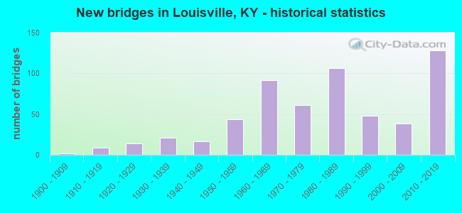
- New bridges - historical statistics
- 21900-1909
- 91910-1919
- 141920-1929
- 211930-1939
- 171940-1949
- 441950-1959
- 921960-1969
- 611970-1979
- 1061980-1989
- 481990-1999
- 382000-2009
- 1282010-2019
- 12020-2022
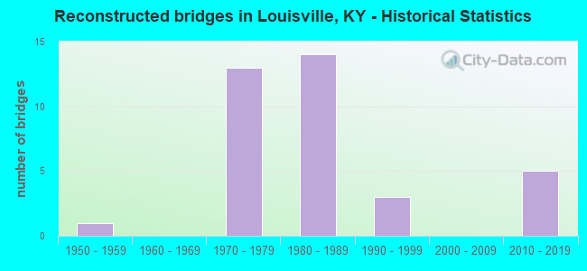
- Reconstructed bridges - Historical Statistics
- 11950-1959
- 01960-1969
- 131970-1979
- 141980-1989
- 31990-1999
- 02000-2009
- 52010-2019
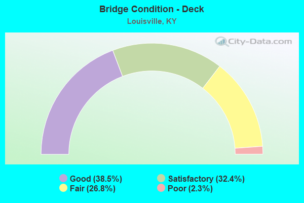
- Bridge Condition - Deck
- 38.5%Good
- 32.4%Satisfactory
- 26.8%Fair
- 2.3%Poor
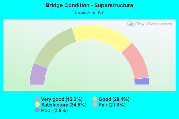
- Bridge Condition - Superstructure
- 12.2%Very good
- 28.4%Good
- 34.5%Satisfactory
- 21.0%Fair
- 3.9%Poor
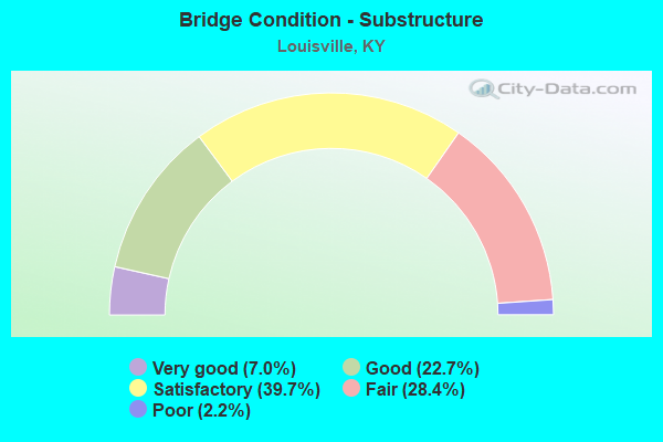
- Bridge Condition - Substructure
- 7.0%Very good
- 22.7%Good
- 39.7%Satisfactory
- 28.4%Fair
- 2.2%Poor
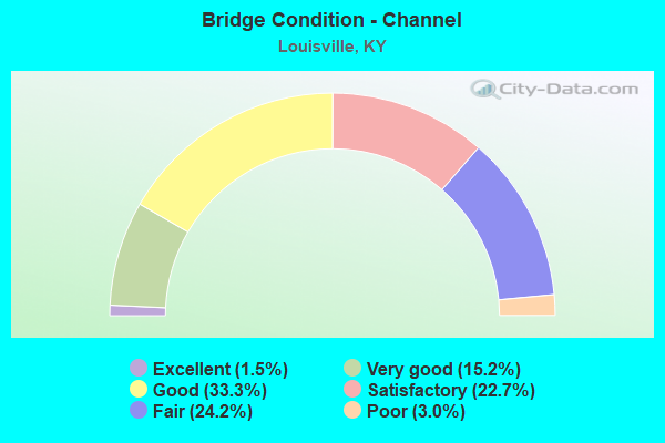
- Bridge Condition - Channel
- 1.5%Excellent
- 15.2%Very good
- 33.3%Good
- 22.7%Satisfactory
- 24.2%Fair
- 3.0%Poor
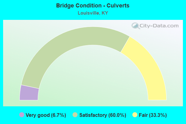
- Bridge Condition - Culverts
- 6.7%Very good
- 60.0%Satisfactory
- 33.3%Fair
Find on map >> Show street view
Structure Number: 56B00185N, Location: 0.7 MI S OF US 150 (Lat: 38.235278, Lng: -85.751389), Route carried "on" structure: Interstate 65, Year Built: 1960, Year Reconstructed: 1982, Status: Open, Structure Length: 8.63m (28.31ft), Average Daily Traffic: 96,754 (year 2020), Truck Traffic: 15%, Average Future Daily Traffic: 103,526 (year 2040), Design Load: HS 20, Features Intersected: S FLOYD ST
Minimum Vertical Clearance: 30+ m (98+ ft), Kilometerpoint: 216.505, Lanes on structure: 6, Lanes under structure: 2, Base Highway Network: Yes, Owner: State Highway Agency, Approaching Roadway Width: 30.3m (99.4ft), Skew: 35 degrees, Material/Design: Steel continuous, Design/Construction: Stringer/Multi-beam, Number Of Spans In Main Unit: 3, Length of Maximum Span: 38.2m (125.3ft), Curb-To-Curb Width: 30.3m (99.4ft), Out-to-Out Width: 32.1m (105.3ft)
Condition: Deck: Fair, Superstructure: Satisfactory, Substructure: Fair, Operating Rating: 62.8 metric tons, Method Used To Determine Operating Rating: Load Factor (LF), Inventory Rating: 37.6 metric tons, Method Used To Determine Inventory Rating: Load Factor (LF), Structural Evaluation: Somewhat better than minimum adequacy, Deck Geometry: Superior to present desirable criteria, Underclear: Somewhat better than minimum adequacy, Approach Roadway Alignment: Equal to present desirable criteria, Length Of Structure Improvement: 0.86m (2.82ft), Designated Inspection Frequency: Every 24 months, Inspection Date: December 2020, Bridge Improvement Cost: $3,712,000, Total Project Cost: $3,711,000, Deck Structure Type: Concrete Cast-file-Place, Wearing Surface/Protective System: Wearing Surface: Bituminous, Deck Protection: Epoxy Coated Reinforcing
Find on map >> Show street view
Structure Number: 56B00186N, Location: 0.8 MI S OF US 150 (Lat: 38.234167, Lng: -85.751111), Route carried "on" structure: Interstate 65, Year Built: 1960, Year Reconstructed: 1982, Status: Open, Structure Length: 4.82m (15.81ft), Average Daily Traffic: 96,754 (year 2020), Truck Traffic: 15%, Average Future Daily Traffic: 103,526 (year 2040), Design Load: HS 20, Features Intersected: E OAK ST
Minimum Vertical Clearance: 30+ m (98+ ft), Kilometerpoint: 216.363, Lanes on structure: 6, Lanes under structure: 2, Base Highway Network: Yes, Owner: State Highway Agency, Approaching Roadway Width: 36.3m (119.1ft), Skew: 32 degrees, Material/Design: Steel continuous, Design/Construction: Stringer/Multi-beam, Number Of Spans In Main Unit: 3, Length of Maximum Span: 20.8m (68.2ft), Curb-To-Curb Width: 36.3m (119.1ft), Out-to-Out Width: 38.0m (124.7ft)
Condition: Deck: Fair, Superstructure: Satisfactory, Substructure: Fair, Operating Rating: 60.6 metric tons, Method Used To Determine Operating Rating: Load Factor (LF), Inventory Rating: 36.4 metric tons, Method Used To Determine Inventory Rating: Load Factor (LF), Structural Evaluation: Somewhat better than minimum adequacy, Deck Geometry: Superior to present desirable criteria, Underclear: Meets minimum limits, Approach Roadway Alignment: Equal to present desirable criteria, Length Of Structure Improvement: 0.48m (1.57ft), Designated Inspection Frequency: Every 24 months, Inspection Date: December 2020, Bridge Improvement Cost: $2,480,000, Total Project Cost: $2,480,000, Deck Structure Type: Concrete Cast-file-Place, Wearing Surface/Protective System: Wearing Surface: Bituminous, Deck Protection: Epoxy Coated Reinforcing
Find on map >> Show street view
Structure Number: 56B00187N, Location: 1.3 MI N OF US 60A (Lat: 38.231389, Lng: -85.750833), Route carried "on" structure: Interstate 65, Year Built: 1960, Year Reconstructed: 1982, Status: Open, Structure Length: 4.81m (15.78ft), Average Daily Traffic: 96,754 (year 2020), Truck Traffic: 15%, Average Future Daily Traffic: 103,526 (year 2040), Design Load: HS 20, Features Intersected: E ORMSBY AVE
Minimum Vertical Clearance: 30+ m (98+ ft), Kilometerpoint: 216.043, Lanes on structure: 6, Lanes under structure: 2, Base Highway Network: Yes, Owner: State Highway Agency, Approaching Roadway Width: 31.9m (104.7ft), Skew: 30 degrees, Material/Design: Steel continuous, Design/Construction: Stringer/Multi-beam, Number Of Spans In Main Unit: 3, Length of Maximum Span: 19.4m (63.6ft), Curb-To-Curb Width: 31.9m (104.7ft), Out-to-Out Width: 33.7m (110.6ft)
Condition: Deck: Fair, Superstructure: Satisfactory, Substructure: Satisfactory, Operating Rating: 49.9 metric tons, Method Used To Determine Operating Rating: Load Factor (LF), Inventory Rating: 29.9 metric tons, Method Used To Determine Inventory Rating: Load Factor (LF), Structural Evaluation: Equal to present minimum criteria, Deck Geometry: Superior to present desirable criteria, Underclear: Somewhat better than minimum adequacy, Approach Roadway Alignment: Equal to present desirable criteria, Length Of Structure Improvement: 0.48m (1.57ft), Designated Inspection Frequency: Every 24 months, Inspection Date: December 2020, Bridge Improvement Cost: $2,182,000, Total Project Cost: $2,182,000, Deck Structure Type: Concrete Cast-file-Place, Wearing Surface/Protective System: Wearing Surface: Bituminous, Deck Protection: Epoxy Coated Reinforcing
Find on map >> Show street view
Structure Number: 56B00188N, Location: 0.2 MI S OF US 150 (Lat: 38.243056, Lng: -85.752778), Route carried "on" structure: Interstate 65, Year Built: 1960, Year Reconstructed: 1980, Status: Open, Structure Length: 4.81m (15.78ft), Average Daily Traffic: 96,754 (year 2020), Truck Traffic: 15%, Average Future Daily Traffic: 103,526 (year 2040), Design Load: HS 20, Features Intersected: COLLEGE ST
Minimum Vertical Clearance: 30+ m (98+ ft), Kilometerpoint: 217.385, Lanes on structure: 6, Lanes under structure: 1, Base Highway Network: Yes, Owner: State Highway Agency, Approaching Roadway Width: 32.8m (107.6ft), Skew: 30 degrees, Material/Design: Steel continuous, Design/Construction: Stringer/Multi-beam, Number Of Spans In Main Unit: 3, Length of Maximum Span: 19.4m (63.6ft), Curb-To-Curb Width: 43.6m (143.0ft), Out-to-Out Width: 45.4m (149.0ft)
Condition: Deck: Satisfactory, Superstructure: Satisfactory, Substructure: Satisfactory, Operating Rating: 50.6 metric tons, Method Used To Determine Operating Rating: Load Factor (LF), Inventory Rating: 30.4 metric tons, Method Used To Determine Inventory Rating: Load Factor (LF), Structural Evaluation: Equal to present minimum criteria, Deck Geometry: Superior to present desirable criteria, Underclear: Somewhat better than minimum adequacy, Approach Roadway Alignment: Equal to present desirable criteria, Length Of Structure Improvement: 0.48m (1.57ft), Designated Inspection Frequency: Every 24 months, Inspection Date: December 2020, Bridge Improvement Cost: $2,939,000, Total Project Cost: $2,938,000, Deck Structure Type: Concrete Cast-file-Place, Wearing Surface/Protective System: Wearing Surface: Bituminous, Deck Protection: Epoxy Coated Reinforcing
Find on map >> Show street view
Structure Number: 56B00189N, Location: 0.3 MI S OF US 150 (Lat: 38.241389, Lng: -85.753056), Route carried "on" structure: Interstate 65, Year Built: 1960, Year Reconstructed: 1980, Status: Open, Structure Length: 4.81m (15.78ft), Average Daily Traffic: 96,754 (year 2020), Truck Traffic: 15%, Average Future Daily Traffic: 103,526 (year 2040), Design Load: HS 20, Features Intersected: E BRECKINRIDGE ST
Minimum Vertical Clearance: 30+ m (98+ ft), Kilometerpoint: 217.191, Lanes on structure: 6, Lanes under structure: 2, Base Highway Network: Yes, Owner: State Highway Agency, Approaching Roadway Width: 32.8m (107.6ft), Skew: 30 degrees, Material/Design: Steel continuous, Design/Construction: Stringer/Multi-beam, Number Of Spans In Main Unit: 3, Length of Maximum Span: 19.4m (63.6ft), Curb-To-Curb Width: 32.8m (107.6ft), Out-to-Out Width: 34.5m (113.2ft)
Condition: Deck: Satisfactory, Superstructure: Fair, Substructure: Satisfactory, Operating Rating: 47.0 metric tons, Method Used To Determine Operating Rating: Load Factor (LF), Inventory Rating: 28.2 metric tons, Method Used To Determine Inventory Rating: Load Factor (LF), Structural Evaluation: Somewhat better than minimum adequacy, Deck Geometry: Superior to present desirable criteria, Underclear: Somewhat better than minimum adequacy, Approach Roadway Alignment: Equal to present desirable criteria, Length Of Structure Improvement: 0.48m (1.57ft), Designated Inspection Frequency: Every 24 months, Inspection Date: December 2020, Bridge Improvement Cost: $2,238,000, Total Project Cost: $2,237,000, Deck Structure Type: Concrete Cast-file-Place, Wearing Surface/Protective System: Wearing Surface: Bituminous, Deck Protection: Epoxy Coated Reinforcing
Find on map >> Show street view
Structure Number: 56B00190N, Location: 0.25 MI N OF ST CATHERINE (Lat: 38.240000, Lng: -85.753056), Route carried "on" structure: Interstate 65, Year Built: 1960, Year Reconstructed: 1982, Status: Open, Structure Length: 4.82m (15.81ft), Average Daily Traffic: 96,754 (year 2020), Truck Traffic: 15%, Average Future Daily Traffic: 103,526 (year 2040), Design Load: HS 20, Features Intersected: CALDWELL ST
Minimum Vertical Clearance: 30+ m (98+ ft), Kilometerpoint: 217.030, Lanes on structure: 6, Lanes under structure: 1, Base Highway Network: Yes, Owner: State Highway Agency, Approaching Roadway Width: 32.8m (107.6ft), Skew: 30 degrees, Material/Design: Steel continuous, Design/Construction: Stringer/Multi-beam, Number Of Spans In Main Unit: 3, Length of Maximum Span: 19.4m (63.6ft), Curb-To-Curb Width: 32.8m (107.6ft), Out-to-Out Width: 34.5m (113.2ft)
Condition: Deck: Satisfactory, Superstructure: Satisfactory, Substructure: Satisfactory, Operating Rating: 54.6 metric tons, Method Used To Determine Operating Rating: Load Factor (LF), Inventory Rating: 32.7 metric tons, Method Used To Determine Inventory Rating: Load Factor (LF), Structural Evaluation: Equal to present minimum criteria, Deck Geometry: Superior to present desirable criteria, Underclear: Somewhat better than minimum adequacy, Approach Roadway Alignment: Equal to present desirable criteria, Length Of Structure Improvement: 0.48m (1.57ft), Designated Inspection Frequency: Every 24 months, Inspection Date: December 2020, Bridge Improvement Cost: $2,238,000, Total Project Cost: $2,237,000, Deck Structure Type: Concrete Cast-file-Place, Wearing Surface/Protective System: Wearing Surface: Bituminous, Deck Protection: Epoxy Coated Reinforcing
Find on map >> Show street view
Structure Number: 56B00191N, Location: 0.5 MI S OF US 31E (Lat: 38.246111, Lng: -85.752222), Route carried "on" structure: Interstate 65, Year Built: 1960, Year Reconstructed: 1980, Status: Posted for load, Structure Length: 36.82m (120.80ft), Average Daily Traffic: 84,001 (year 2012), Truck Traffic: 15%, Average Future Daily Traffic: 89,881 (year 2032), Design Load: HS 20, Features Intersected: JACOB, BROADWAY, GRAY ST
Minimum Vertical Clearance: 30+ m (98+ ft), Kilometerpoint: 217.701, Lanes on structure: 6, Lanes under structure: 9, Base Highway Network: Yes, Owner: State Highway Agency, Approaching Roadway Width: 30.3m (99.4ft), Skew: 30 degrees, Material/Design: Steel continuous, Design/Construction: Stringer/Multi-beam, Number Of Spans In Main Unit: 21, Length of Maximum Span: 37.7m (123.7ft), Curb-To-Curb Width: 30.3m (99.4ft), Out-to-Out Width: 32.1m (105.3ft)
Condition: Deck: Satisfactory, Superstructure: Fair, Substructure: Fair, Operating Rating: 49.4 metric tons, Method Used To Determine Operating Rating: Load Factor (LF), Inventory Rating: 25.6 metric tons, Method Used To Determine Inventory Rating: Load Factor (LF), Structural Evaluation: Somewhat better than minimum adequacy, Deck Geometry: Superior to present desirable criteria, Underclear: Meets minimum limits, Approach Roadway Alignment: Equal to present desirable criteria, Length Of Structure Improvement: 3.68m (12.07ft), Designated Inspection Frequency: Every 24 months, Inspection Date: December 2020, Bridge Improvement Cost: $19,080,000, Total Project Cost: $19,080,000, Deck Structure Type: Concrete Cast-file-Place, Wearing Surface/Protective System: Wearing Surface: Bituminous, Deck Protection: Epoxy Coated Reinforcing
Find on map >> Show street view
Structure Number: 56B00192N, Location: 0.18 MI N OF US 150 (Lat: 38.248333, Lng: -85.752222), Route carried "on" structure: Interstate 65, Year Built: 1963, Year Reconstructed: 1980, Status: Open, Structure Length: 13.27m (43.54ft), Average Daily Traffic: 84,001 (year 2012), Truck Traffic: 15%, Average Future Daily Traffic: 89,881 (year 2032), Design Load: HS 20, Features Intersected: E CHESTNUT ST
Minimum Vertical Clearance: 30+ m (98+ ft), Kilometerpoint: 217.962, Lanes on structure: 6, Lanes under structure: 3, Base Highway Network: Yes, Owner: State Highway Agency, Approaching Roadway Width: 29.0m (95.1ft), Skew: 30 degrees, Material/Design: Prestressed concrete continuous, Design/Construction: Stringer/Multi-beam, Number Of Spans In Main Unit: 9, Length of Maximum Span: 19.4m (63.6ft), Curb-To-Curb Width: 29.0m (95.1ft), Out-to-Out Width: 30.7m (100.7ft)
Condition: Deck: Satisfactory, Superstructure: Fair, Substructure: Fair, Operating Rating: 72.6 metric tons, Method Used To Determine Operating Rating: Load Factor (LF), Inventory Rating: 43.5 metric tons, Method Used To Determine Inventory Rating: Load Factor (LF), Structural Evaluation: Somewhat better than minimum adequacy, Deck Geometry: Better than present minimum criteria, Underclear: Meets minimum limits, Approach Roadway Alignment: Equal to present desirable criteria, Length Of Structure Improvement: 1.18m (3.87ft), Designated Inspection Frequency: Every 24 months, Inspection Date: December 2020, Bridge Improvement Cost: $5,846,000, Total Project Cost: $5,845,000, Deck Structure Type: Concrete Cast-file-Place, Wearing Surface/Protective System: Wearing Surface: Bituminous, Deck Protection: Epoxy Coated Reinforcing
Find on map >> Show street view
Structure Number: 56B00193N, Location: 0.15 MI N OF E CHESTNUT (Lat: 38.250278, Lng: -85.751389), Route carried "on" structure: Interstate 65, Year Built: 1963, Year Reconstructed: 1980, Status: Open, Structure Length: 10.52m (34.51ft), Average Daily Traffic: 84,001 (year 2012), Truck Traffic: 15%, Average Future Daily Traffic: 89,881 (year 2032), Design Load: H 20, Features Intersected: BROOK ST & MUHAMMAD ALI
Minimum Vertical Clearance: 30+ m (98+ ft), Kilometerpoint: 218.201, Lanes on structure: 6, Lanes under structure: 8, Base Highway Network: Yes, Owner: State Highway Agency, Approaching Roadway Width: 29.0m (95.1ft), Skew: 39 degrees, Material/Design: Steel, Design/Construction: Stringer/Multi-beam, Number Of Spans In Main Unit: 5, Length of Maximum Span: 44.0m (144.4ft), Curb-To-Curb Width: 29.0m (95.1ft), Out-to-Out Width: 30.7m (100.7ft)
Condition: Deck: Fair, Superstructure: Fair, Substructure: Fair, Operating Rating: 50.2 metric tons, Method Used To Determine Operating Rating: Load Factor (LF), Inventory Rating: 30.1 metric tons, Method Used To Determine Inventory Rating: Load Factor (LF), Structural Evaluation: Somewhat better than minimum adequacy, Deck Geometry: Better than present minimum criteria, Underclear: Meets minimum limits, Approach Roadway Alignment: Equal to present desirable criteria, Length Of Structure Improvement: 1.38m (4.53ft), Designated Inspection Frequency: Every 24 months, Inspection Date: December 2020, Bridge Improvement Cost: $5,368,000, Total Project Cost: $5,367,000, Deck Structure Type: Concrete Cast-file-Place, Wearing Surface/Protective System: Wearing Surface: Bituminous
Find on map >> Show street view
Structure Number: 56B00194N, Location: 0.1 MI S OF 1ST ST (Lat: 38.250556, Lng: -85.751944), Route carried "on" structure: Ramp Interstate 65, Year Built: 1963, Year Reconstructed: 1980, Status: Open, Structure Length: 1.96m (6.43ft), Average Daily Traffic: 84,001 (year 2012), Truck Traffic: 15%, Average Future Daily Traffic: 89,881 (year 2032), Design Load: HS 20, Features Intersected: E MUHAMMAD ALI BLVD
Minimum Vertical Clearance: 30+ m (98+ ft), Kilometerpoint: 218.229, Lanes on structure: 1, Lanes under structure: 4, Owner: State Highway Agency, Approaching Roadway Width: 7.3m (24.0ft), Material/Design: Steel, Design/Construction: Stringer/Multi-beam, Number Of Spans In Main Unit: 1, Length of Maximum Span: 19.0m (62.3ft), Curb-To-Curb Width: 7.3m (24.0ft), Out-to-Out Width: 8.4m (27.6ft)
Condition: Deck: Good, Superstructure: Good, Substructure: Satisfactory, Operating Rating: 83.0 metric tons, Method Used To Determine Operating Rating: Load Factor (LF), Inventory Rating: 49.8 metric tons, Method Used To Determine Inventory Rating: Load Factor (LF), Structural Evaluation: Equal to present minimum criteria, Deck Geometry: Better than present minimum criteria, Underclear: Meets minimum limits, Approach Roadway Alignment: Equal to present desirable criteria, Length Of Structure Improvement: 0.19m (0.62ft), Designated Inspection Frequency: Every 24 months, Inspection Date: December 2020, Bridge Improvement Cost: $212,000, Total Project Cost: $212,000, Deck Structure Type: Concrete Cast-file-Place, Wearing Surface/Protective System: Wearing Surface: Bituminous
Find on map >> Show street view
Structure Number: 56B00195R, Location: 0.15 MI N OF MUH ALI BLVD (Lat: 38.251389, Lng: -85.748611), Route carried "on" structure: Interstate 65, Year Built: 1963, Year Reconstructed: 1980, Status: Open, Structure Length: 2.44m (8.01ft), Average Daily Traffic: 42,001 (year 2012), Truck Traffic: 15%, Average Future Daily Traffic: 44,941 (year 2032), Design Load: HS 20, Features Intersected: S FLOYD ST
Minimum Vertical Clearance: 30+ m (98+ ft), Kilometerpoint: 218.476, Lanes on structure: 3, Lanes under structure: 2, Base Highway Network: Yes, Owner: State Highway Agency, Approaching Roadway Width: 17.6m (57.7ft), Skew: 3 degrees, Material/Design: Steel, Design/Construction: Stringer/Multi-beam, Number Of Spans In Main Unit: 1, Length of Maximum Span: 22.4m (73.5ft), Curb-To-Curb Width: 17.6m (57.7ft), Out-to-Out Width: 18.4m (60.4ft)
Condition: Deck: Good, Superstructure: Good, Substructure: Satisfactory, Operating Rating: 61.6 metric tons, Method Used To Determine Operating Rating: Load Factor (LF), Inventory Rating: 36.9 metric tons, Method Used To Determine Inventory Rating: Load Factor (LF), Structural Evaluation: Equal to present minimum criteria, Deck Geometry: Better than present minimum criteria, Underclear: Equal to present minimum criteria, Approach Roadway Alignment: Equal to present desirable criteria, Length Of Structure Improvement: 0.23m (0.75ft), Designated Inspection Frequency: Every 24 months, Inspection Date: December 2020, Bridge Improvement Cost: $1,067,000, Total Project Cost: $1,067,000, Deck Structure Type: Concrete Cast-file-Place, Wearing Surface/Protective System: Wearing Surface: Bituminous
Find on map >> Show street view
Structure Number: 56B00196N, Location: 0.1 MI N OF E JEFFERSON (Lat: 38.252500, Lng: -85.748333), Route carried "on" structure: Ramp Interstate 65, Year Built: 1963, Year Reconstructed: 1980, Status: Open, Structure Length: 3.87m (12.70ft), Average Daily Traffic: 84,001 (year 2012), Truck Traffic: 15%, Average Future Daily Traffic: 89,881 (year 2032), Design Load: HS 20, Features Intersected: S FLOYD ST
Minimum Vertical Clearance: 30+ m (98+ ft), Kilometerpoint: 218.470, Lanes on structure: 2, Lanes under structure: 2, Owner: State Highway Agency, Approaching Roadway Width: 10.4m (34.1ft), Material/Design: Steel, Design/Construction: Stringer/Multi-beam, Number Of Spans In Main Unit: 1, Number Of Approach Spans: 2, Length of Maximum Span: 18.9m (62.0ft), Curb-To-Curb Width: 10.4m (34.1ft), Out-to-Out Width: 11.4m (37.4ft)
Condition: Deck: Fair, Superstructure: Satisfactory, Substructure: Fair, Operating Rating: 71.1 metric tons, Method Used To Determine Operating Rating: Load Factor (LF), Inventory Rating: 42.6 metric tons, Method Used To Determine Inventory Rating: Load Factor (LF), Structural Evaluation: Somewhat better than minimum adequacy, Deck Geometry: Better than present minimum criteria, Underclear: Somewhat better than minimum adequacy, Approach Roadway Alignment: Equal to present desirable criteria, Length Of Structure Improvement: 0.40m (1.31ft), Designated Inspection Frequency: Every 24 months, Inspection Date: December 2020, Bridge Improvement Cost: $606,000, Total Project Cost: $606,000, Deck Structure Type: Concrete Cast-file-Place, Wearing Surface/Protective System: Wearing Surface: Latex Concrete
Find on map >> Show street view
Structure Number: 56B00197R, Location: 0.2 MI N OF MUH ALI BLVD (Lat: 38.251944, Lng: -85.747778), Route carried "on" structure: Interstate 65, Year Built: 1963, Year Reconstructed: 1980, Status: Open, Structure Length: 2.98m (9.78ft), Average Daily Traffic: 42,001 (year 2012), Truck Traffic: 15%, Average Future Daily Traffic: 44,941 (year 2032), Design Load: HS 20, Features Intersected: E LIBERTY ST
Minimum Vertical Clearance: 30+ m (98+ ft), Kilometerpoint: 218.571, Lanes on structure: 3, Lanes under structure: 5, Base Highway Network: Yes, Owner: State Highway Agency, Approaching Roadway Width: 15.8m (51.8ft), Skew: 3 degrees, Material/Design: Steel, Design/Construction: Stringer/Multi-beam, Number Of Spans In Main Unit: 1, Length of Maximum Span: 29.0m (95.1ft), Curb-To-Curb Width: 15.8m (51.8ft), Out-to-Out Width: 16.7m (54.8ft)
Condition: Deck: Fair, Superstructure: Satisfactory, Substructure: Satisfactory, Operating Rating: 92.7 metric tons, Method Used To Determine Operating Rating: Load Factor (LF), Inventory Rating: 55.6 metric tons, Method Used To Determine Inventory Rating: Load Factor (LF), Structural Evaluation: Equal to present minimum criteria, Deck Geometry: Somewhat better than minimum adequacy, Underclear: Equal to present minimum criteria, Approach Roadway Alignment: Equal to present desirable criteria, Length Of Structure Improvement: 0.30m (0.98ft), Designated Inspection Frequency: Every 24 months, Inspection Date: December 2020, Bridge Improvement Cost: $1,372,000, Total Project Cost: $1,372,000, Deck Structure Type: Concrete Cast-file-Place, Wearing Surface/Protective System: Wearing Surface: Bituminous
Find on map >> Show street view
Structure Number: 56B00205N, Location: 500 FT N OF CRITTENDEN DR (Lat: 38.208611, Lng: -85.752222), Route carried "on" structure: Interstate 65, Year Built: 1957, Year Reconstructed: 1982, Status: Open, Structure Length: 11.19m (36.71ft), Average Daily Traffic: 100,741 (year 2020), Truck Traffic: 11%, Average Future Daily Traffic: 107,792 (year 2040), Design Load: HS 20, Features Intersected: NS RAILROAD
Minimum Vertical Clearance: 30+ m (98+ ft), Kilometerpoint: 213.475, Lanes on structure: 6, Base Highway Network: Yes, Owner: State Highway Agency, Approaching Roadway Width: 31.5m (103.3ft), Skew: 34 degrees, Material/Design: Steel continuous, Design/Construction: Stringer/Multi-beam, Number Of Spans In Main Unit: 4, Length of Maximum Span: 32.1m (105.3ft), Curb-To-Curb Width: 31.5m (103.3ft), Out-to-Out Width: 33.3m (109.3ft)
Condition: Deck: Fair, Superstructure: Fair, Substructure: Fair, Operating Rating: 62.6 metric tons, Method Used To Determine Operating Rating: Load Factor (LF), Inventory Rating: 37.2 metric tons, Method Used To Determine Inventory Rating: Load Factor (LF), Structural Evaluation: Somewhat better than minimum adequacy, Deck Geometry: Superior to present desirable criteria, Underclear: Equal to present minimum criteria, Approach Roadway Alignment: Equal to present desirable criteria, Designated Inspection Frequency: Every 24 months, Inspection Date: October 2020, Deck Structure Type: Concrete Cast-file-Place, Wearing Surface/Protective System: Wearing Surface: Bituminous, Deck Protection: Epoxy Coated Reinforcing
Find on map >> Show street view
Structure Number: 56B00206N, Location: 0.35 MI S OF OAK ST NTRCH (Lat: 38.229167, Lng: -85.751389), Route carried "on" structure: Interstate 65, Year Built: 1957, Year Reconstructed: 1982, Status: Open, Structure Length: 3.90m (12.80ft), Average Daily Traffic: 96,754 (year 2020), Truck Traffic: 15%, Average Future Daily Traffic: 103,526 (year 2040), Design Load: HS 20, Features Intersected: WOODBINE ST
Minimum Vertical Clearance: 30+ m (98+ ft), Kilometerpoint: 215.795, Lanes on structure: 6, Lanes under structure: 2, Base Highway Network: Yes, Owner: State Highway Agency, Approaching Roadway Width: 29.0m (95.1ft), Skew: 30 degrees, Material/Design: Concrete continuous, Design/Construction: Tee Beam, Number Of Spans In Main Unit: 3, Length of Maximum Span: 17.7m (58.1ft), Curb-To-Curb Width: 29.0m (95.1ft), Out-to-Out Width: 30.9m (101.4ft)
Condition: Deck: Satisfactory, Superstructure: Satisfactory, Substructure: Fair, Operating Rating: 77.1 metric tons, Method Used To Determine Operating Rating: Load Factor (LF), Inventory Rating: 46.3 metric tons, Method Used To Determine Inventory Rating: Load Factor (LF), Structural Evaluation: Somewhat better than minimum adequacy, Deck Geometry: Better than present minimum criteria, Underclear: Meets minimum limits, Approach Roadway Alignment: Equal to present desirable criteria, Length Of Structure Improvement: 0.39m (1.28ft), Designated Inspection Frequency: Every 24 months, Inspection Date: December 2020, Bridge Improvement Cost: $1,621,000, Total Project Cost: $1,620,000, Deck Structure Type: Concrete Cast-file-Place, Wearing Surface/Protective System: Wearing Surface: Bituminous
Find on map >> Show street view
Structure Number: 56B00207N, Location: 0.4 MI S OF OAK ST NTRCH (Lat: 38.228056, Lng: -85.751389), Route carried "on" structure: Interstate 65, Year Built: 1957, Year Reconstructed: 1982, Status: Open, Structure Length: 4.23m (13.88ft), Average Daily Traffic: 96,754 (year 2020), Truck Traffic: 15%, Average Future Daily Traffic: 103,526 (year 2040), Design Load: HS 20, Features Intersected: I-65 SB ON RAMP
Minimum Vertical Clearance: 30+ m (98+ ft), Kilometerpoint: 215.683, Lanes on structure: 6, Lanes under structure: 1, Base Highway Network: Yes, Owner: State Highway Agency, Approaching Roadway Width: 29.0m (95.1ft), Skew: 30 degrees, Material/Design: Concrete continuous, Design/Construction: Tee Beam, Number Of Spans In Main Unit: 3, Length of Maximum Span: 19.2m (63.0ft), Curb-To-Curb Width: 29.0m (95.1ft), Out-to-Out Width: 30.9m (101.4ft)
Condition: Deck: Fair, Superstructure: Satisfactory, Substructure: Satisfactory, Operating Rating: 66.6 metric tons, Method Used To Determine Operating Rating: Load Factor (LF), Inventory Rating: 39.9 metric tons, Method Used To Determine Inventory Rating: Load Factor (LF), Structural Evaluation: Equal to present minimum criteria, Deck Geometry: Better than present minimum criteria, Underclear: High priority of corrective action, Approach Roadway Alignment: Equal to present desirable criteria, Length Of Structure Improvement: 0.42m (1.38ft), Designated Inspection Frequency: Every 24 months, Inspection Date: December 2020, Bridge Improvement Cost: $1,760,000, Total Project Cost: $1,760,000, Deck Structure Type: Concrete Cast-file-Place, Wearing Surface/Protective System: Wearing Surface: Bituminous
Find on map >> Show street view
Structure Number: 56B00208N, Location: AT WOODBINE ST (Lat: 38.228056, Lng: -85.751111), Route carried "on" structure: Ramp Interstate 65, Year Built: 1957, Status: Open, Structure Length: 4.25m (13.94ft), Average Daily Traffic: 96,754 (year 2020), Truck Traffic: 15%, Average Future Daily Traffic: 103,526 (year 2040), Design Load: HS 20, Features Intersected: I-65 SB ON RAMP
Minimum Vertical Clearance: 30+ m (98+ ft), Kilometerpoint: 215.678, Lanes on structure: 1, Lanes under structure: 1, Owner: State Highway Agency, Approaching Roadway Width: 5.5m (18.0ft), Skew: 3 degrees, Material/Design: Concrete continuous, Design/Construction: Tee Beam, Number Of Spans In Main Unit: 3, Length of Maximum Span: 19.2m (63.0ft), Curb or Sidewalk Widths: Left: 1.1m (3.6ft), Right: 1.1m (3.6ft), Curb-To-Curb Width: 5.5m (18.0ft), Out-to-Out Width: 8.4m (27.6ft)
Condition: Deck: Fair, Superstructure: Satisfactory, Substructure: Satisfactory, Operating Rating: 68.5 metric tons, Method Used To Determine Operating Rating: Load Factor (LF), Inventory Rating: 41.1 metric tons, Method Used To Determine Inventory Rating: Load Factor (LF), Structural Evaluation: Equal to present minimum criteria, Deck Geometry: Meets minimum limits, Underclear: High priority of corrective action, Approach Roadway Alignment: Equal to present desirable criteria, Length Of Structure Improvement: 0.42m (1.38ft), Designated Inspection Frequency: Every 24 months, Inspection Date: December 2020, Bridge Improvement Cost: $480,000, Total Project Cost: $479,000, Deck Structure Type: Concrete Cast-file-Place, Wearing Surface/Protective System: Wearing Surface: Bituminous
Find on map >> Show street view
Structure Number: 56B00209N, Location: 0.45 MI N OF I-264 NTRCH (Lat: 38.196667, Lng: -85.733611), Route carried "on" structure: Interstate 65, Year Built: 1957, Year Reconstructed: 1985, Status: Posted for load, Structure Length: 4.43m (14.53ft), Average Daily Traffic: 100,741 (year 2020), Truck Traffic: 11%, Average Future Daily Traffic: 107,792 (year 2040), Design Load: HS 20, Features Intersected: PHILLIPS LN
Minimum Vertical Clearance: 30+ m (98+ ft), Kilometerpoint: 211.218, Lanes on structure: 8, Lanes under structure: 2, Base Highway Network: Yes, Owner: State Highway Agency, Approaching Roadway Width: 38.7m (127.0ft), Skew: 32 degrees, Material/Design: Steel continuous, Design/Construction: Stringer/Multi-beam, Number Of Spans In Main Unit: 3, Length of Maximum Span: 17.4m (57.1ft), Curb-To-Curb Width: 38.7m (127.0ft), Out-to-Out Width: 40.5m (132.9ft)
Condition: Deck: Fair, Superstructure: Fair, Substructure: Fair, Operating Rating: 42.3 metric tons, Method Used To Determine Operating Rating: Load Factor (LF), Inventory Rating: 25.3 metric tons, Method Used To Determine Inventory Rating: Load Factor (LF), Structural Evaluation: Somewhat better than minimum adequacy, Deck Geometry: Superior to present desirable criteria, Underclear: Equal to present minimum criteria, Approach Roadway Alignment: Equal to present desirable criteria, Bridge Posting: Required (Relationship of Operating Rating to Maximum Legal Load: 0.1 - 9.9% below), Length Of Structure Improvement: 0.44m (1.44ft), Designated Inspection Frequency: Every 24 months, Inspection Date: October 2020, Bridge Improvement Cost: $1,823,000, Total Project Cost: $1,823,000, Deck Structure Type: Concrete Cast-file-Place, Wearing Surface/Protective System: Wearing Surface: Monolithic Concrete, Deck Protection: Epoxy Coated Reinforcing
Find on map >> Show street view
Structure Number: 56B00210N, Location: 0.55 MI N OF I-264 NTRCH (Lat: 38.197500, Lng: -85.733889), Route carried "on" structure: Interstate 65, Year Built: 1957, Year Reconstructed: 1985, Status: Open, Structure Length: 4.57m (14.99ft), Average Daily Traffic: 100,741 (year 2020), Truck Traffic: 11%, Average Future Daily Traffic: 107,792 (year 2040), Design Load: HS 20, Features Intersected: MANNING RD
Minimum Vertical Clearance: 30+ m (98+ ft), Kilometerpoint: 211.305, Lanes on structure: 8, Lanes under structure: 1, Base Highway Network: Yes, Owner: State Highway Agency, Approaching Roadway Width: 36.6m (120.1ft), Skew: 32 degrees, Material/Design: Steel continuous, Design/Construction: Stringer/Multi-beam, Number Of Spans In Main Unit: 3, Length of Maximum Span: 17.7m (58.1ft), Curb-To-Curb Width: 36.3m (119.1ft), Out-to-Out Width: 38.2m (125.3ft)
Condition: Deck: Fair, Superstructure: Fair, Substructure: Fair, Operating Rating: 54.9 metric tons, Method Used To Determine Operating Rating: Load Factor (LF), Inventory Rating: 32.9 metric tons, Method Used To Determine Inventory Rating: Load Factor (LF), Structural Evaluation: Somewhat better than minimum adequacy, Deck Geometry: Better than present minimum criteria, Underclear: Superior to present desirable criteria, Approach Roadway Alignment: Equal to present desirable criteria, Length Of Structure Improvement: 0.46m (1.51ft), Designated Inspection Frequency: Every 24 months, Inspection Date: October 2020, Bridge Improvement Cost: $2,319,000, Total Project Cost: $2,319,000, Deck Structure Type: Concrete Cast-file-Place, Wearing Surface/Protective System: Wearing Surface: Bituminous, Deck Protection: Epoxy Coated Reinforcing
Find on map >> Show street view
Structure Number: 56B00211N, Location: 0.6 MI N OF I-264 NTRCH (Lat: 38.198889, Lng: -85.734167), Route carried "on" structure: Interstate 65, Year Built: 1957, Year Reconstructed: 1985, Status: Open, Structure Length: 4.60m (15.09ft), Average Daily Traffic: 100,741 (year 2020), Truck Traffic: 11%, Average Future Daily Traffic: 107,792 (year 2040), Design Load: HS 20, Features Intersected: KFEC GATE 6 DR
Minimum Vertical Clearance: 30+ m (98+ ft), Kilometerpoint: 211.469, Lanes on structure: 8, Lanes under structure: 4, Base Highway Network: Yes, Owner: State Highway Agency, Approaching Roadway Width: 36.6m (120.1ft), Skew: 30 degrees, Material/Design: Steel continuous, Design/Construction: Stringer/Multi-beam, Number Of Spans In Main Unit: 3, Length of Maximum Span: 20.0m (65.6ft), Curb-To-Curb Width: 36.4m (119.4ft), Out-to-Out Width: 38.1m (125.0ft)
Condition: Deck: Fair, Superstructure: Fair, Substructure: Fair, Operating Rating: 51.3 metric tons, Method Used To Determine Operating Rating: Load Factor (LF), Inventory Rating: 30.8 metric tons, Method Used To Determine Inventory Rating: Load Factor (LF), Structural Evaluation: Somewhat better than minimum adequacy, Deck Geometry: Better than present minimum criteria, Underclear: Meets minimum limits, Approach Roadway Alignment: Equal to present desirable criteria, Length Of Structure Improvement: 0.46m (1.51ft), Designated Inspection Frequency: Every 24 months, Inspection Date: October 2020, Bridge Improvement Cost: $1,840,000, Total Project Cost: $1,840,000, Deck Structure Type: Concrete Cast-file-Place, Wearing Surface/Protective System: Wearing Surface: Bituminous, Deck Protection: Epoxy Coated Reinforcing
Find on map >> Show street view
Structure Number: 56B00212N, Location: 0.7 MI S OF US 60A (Lat: 38.206111, Lng: -85.745000), Route carried "on" structure: Interstate 65, Year Built: 1957, Year Reconstructed: 1988, Status: Open, Structure Length: 4.13m (13.55ft), Average Daily Traffic: 100,741 (year 2020), Truck Traffic: 11%, Average Future Daily Traffic: 107,792 (year 2040), Design Load: HS 20, Features Intersected: BRADLEY AVE
Minimum Vertical Clearance: 30+ m (98+ ft), Kilometerpoint: 212.770, Lanes on structure: 7, Lanes under structure: 2, Base Highway Network: Yes, Owner: State Highway Agency, Approaching Roadway Width: 34.1m (111.9ft), Skew: 33 degrees, Material/Design: Steel continuous, Design/Construction: Stringer/Multi-beam, Number Of Spans In Main Unit: 3, Length of Maximum Span: 15.5m (50.9ft), Curb-To-Curb Width: 34.4m (112.9ft), Out-to-Out Width: 36.3m (119.1ft)
Condition: Deck: Fair, Superstructure: Fair, Substructure: Fair, Operating Rating: 55.9 metric tons, Method Used To Determine Operating Rating: Load Factor (LF), Inventory Rating: 33.6 metric tons, Method Used To Determine Inventory Rating: Load Factor (LF), Structural Evaluation: Somewhat better than minimum adequacy, Deck Geometry: Superior to present desirable criteria, Underclear: Meets minimum limits, Approach Roadway Alignment: Equal to present desirable criteria, Length Of Structure Improvement: 0.40m (1.31ft), Designated Inspection Frequency: Every 24 months, Other Special Inspection Frequency: Every 12 months, Inspection Date: October 2020, Other Special Inspection Date: October 2021, Bridge Improvement Cost: $1,671,000, Total Project Cost: $1,671,000, Deck Structure Type: Concrete Cast-file-Place, Wearing Surface/Protective System: Wearing Surface: Bituminous, Deck Protection: Epoxy Coated Reinforcing
Find on map >> Show street view
Structure Number: 56B00213N, Location: 0.3 MI S OF US 60A NTRCH (Lat: 38.207500, Lng: -85.750833), Route carried "on" structure: Interstate 65, Year Built: 1957, Year Reconstructed: 1985, Status: Open, Structure Length: 6.97m (22.87ft), Average Daily Traffic: 100,741 (year 2020), Truck Traffic: 11%, Average Future Daily Traffic: 107,792 (year 2040), Design Load: HS 20, Features Intersected: KY 1631 (CRITTENDEN DR)
Minimum Vertical Clearance: 30+ m (98+ ft), Kilometerpoint: 213.323, Lanes on structure: 6, Lanes under structure: 4, Base Highway Network: Yes, Owner: State Highway Agency, Approaching Roadway Width: 29.0m (95.1ft), Skew: 33 degrees, Material/Design: Steel continuous, Design/Construction: Stringer/Multi-beam, Number Of Spans In Main Unit: 3, Length of Maximum Span: 31.0m (101.7ft), Curb-To-Curb Width: 29.0m (95.1ft), Out-to-Out Width: 30.9m (101.4ft)
Condition: Deck: Satisfactory, Superstructure: Satisfactory, Substructure: Satisfactory, Operating Rating: 59.0 metric tons, Method Used To Determine Operating Rating: Load Factor (LF), Inventory Rating: 35.4 metric tons, Method Used To Determine Inventory Rating: Load Factor (LF), Structural Evaluation: Equal to present minimum criteria, Deck Geometry: Better than present minimum criteria, Underclear: Meets minimum limits, Approach Roadway Alignment: Equal to present desirable criteria, Length Of Structure Improvement: 0.70m (2.30ft), Designated Inspection Frequency: Every 24 months, Inspection Date: October 2020, Bridge Improvement Cost: $2,900,000, Total Project Cost: $2,899,000, Deck Structure Type: Concrete Cast-file-Place, Wearing Surface/Protective System: Wearing Surface: Bituminous, Deck Protection: Epoxy Coated Reinforcing
Find on map >> Show street view
Structure Number: 56B00214L, Location: AT KY/IN STATE LINE (Lat: 38.264722, Lng: -85.743611), Route carried "on" structure: Interstate 65, Year Built: 1964, Year Reconstructed: 2016, Status: Open, Structure Length: 76.15m (249.84ft), Average Daily Traffic: 60,500 (year 2008), Truck Traffic: 15%, Average Future Daily Traffic: 64,735 (year 2028), Design Load: HS 20, Features Intersected: OHIO RIVER
Minimum Vertical Clearance: 5.44m (17.85ft), Kilometerpoint: 220.297, Lanes on structure: 6, Base Highway Network: Yes, Owner: State Highway Agency, Maintenance Responsibility: State Toll Authority, Approaching Roadway Width: 27.8m (91.2ft), Navigation Control: Yes ( Vertical Clearance: 22.0m (72.2ft), Horizontal Clearance: 207.1m (679.5ft)), Material/Design: Steel, Design/Construction: Truss - Thru, Number Of Spans In Main Unit: 5, Length of Maximum Span: 213.4m (700.1ft), Curb-To-Curb Width: 27.8m (91.2ft), Out-to-Out Width: 28.6m (93.8ft)
Condition: Deck: Good, Superstructure: Fair, Substructure: Satisfactory, Channel: Good, Operating Rating: 29.8 metric tons, Method Used To Determine Operating Rating: Load and Resistance Factor Rating (LRFR) rating reported by rating factor(RF) method using HL-93 loadings, Inventory Rating: 23.0 metric tons, Method Used To Determine Inventory Rating: Load and Resistance Factor Rating (LRFR) rating reported by rating factor(RF) method using HL-93 loadings, Structural Evaluation: Somewhat better than minimum adequacy, Deck Geometry: Equal to present minimum criteria, Waterway Adequacy: Superior to present desirable criteria, Approach Roadway Alignment: Equal to present minimum criteria, Designated Inspection Frequency: Every 24 months, Critical Feature Inspection Frequency: Every 24 months, Underwater Inspection Frequency: Every 60 months, Inspection Date: August 2020, Critical Feature Inspection Date: August 2020, Underwater Inspection Date: August 2019, Bridge Improvement Cost: $86,929,000, Total Project Cost: $86,929,000, Deck Structure Type: Concrete Cast-file-Place, Wearing Surface/Protective System: Wearing Surface: Monolithic Concrete, Deck Protection: Epoxy Coated Reinforcing
Find on map >> Show street view
Structure Number: 56B00227L, Location: 0.2 MI E OF I-64 NTRCH (Lat: 38.272222, Lng: -85.808333), Route carried "on" structure: Interstate 264, Year Built: 1962, Status: Open, Structure Length: 2.29m (7.51ft), Average Daily Traffic: 19,356 (year 2012), Truck Traffic: 10%, Average Future Daily Traffic: 20,711 (year 2032), Design Load: H 20, Features Intersected: KY 3082 (BANK ST)
Minimum Vertical Clearance: 30+ m (98+ ft), Kilometerpoint: 0.612, Lanes on structure: 2, Lanes under structure: 3, Base Highway Network: Yes, Owner: State Highway Agency, Approaching Roadway Width: 15.8m (51.8ft), Material/Design: Steel, Design/Construction: Stringer/Multi-beam, Number Of Spans In Main Unit: 1, Length of Maximum Span: 21.3m (69.9ft), Curb-To-Curb Width: 15.8m (51.8ft), Out-to-Out Width: 16.4m (53.8ft)
Condition: Deck: Fair, Superstructure: Satisfactory, Substructure: Fair, Operating Rating: 49.9 metric tons, Method Used To Determine Operating Rating: Load Factor (LF), Inventory Rating: 29.9 metric tons, Method Used To Determine Inventory Rating: Load Factor (LF), Structural Evaluation: Somewhat better than minimum adequacy, Deck Geometry: Superior to present desirable criteria, Underclear: Somewhat better than minimum adequacy, Approach Roadway Alignment: Equal to present desirable criteria, Length Of Structure Improvement: 0.23m (0.75ft), Designated Inspection Frequency: Every 24 months, Inspection Date: June 2021, Bridge Improvement Cost: $599,000, Total Project Cost: $599,000, Deck Structure Type: Concrete Cast-file-Place, Wearing Surface/Protective System: Wearing Surface: Bituminous
Find on map >> Show street view
Structure Number: 56B00227R, Location: 0.2 MI E OF I-64 NTRCH (Lat: 38.271944, Lng: -85.808889), Route carried "on" structure: Interstate 264, Year Built: 1962, Status: Open, Structure Length: 2.29m (7.51ft), Average Daily Traffic: 19,356 (year 2012), Truck Traffic: 10%, Average Future Daily Traffic: 20,711 (year 2032), Design Load: H 20, Features Intersected: KY 3082 (BANK ST)
Minimum Vertical Clearance: 30+ m (98+ ft), Kilometerpoint: 0.546, Lanes on structure: 2, Lanes under structure: 3, Base Highway Network: Yes, Owner: State Highway Agency, Approaching Roadway Width: 15.8m (51.8ft), Material/Design: Steel, Design/Construction: Stringer/Multi-beam, Number Of Spans In Main Unit: 1, Length of Maximum Span: 21.3m (69.9ft), Curb-To-Curb Width: 15.8m (51.8ft), Out-to-Out Width: 16.4m (53.8ft)
Condition: Deck: Satisfactory, Superstructure: Satisfactory, Substructure: Satisfactory, Operating Rating: 49.9 metric tons, Method Used To Determine Operating Rating: Load Factor (LF), Inventory Rating: 29.9 metric tons, Method Used To Determine Inventory Rating: Load Factor (LF), Structural Evaluation: Equal to present minimum criteria, Deck Geometry: Superior to present desirable criteria, Underclear: Somewhat better than minimum adequacy, Approach Roadway Alignment: Equal to present desirable criteria, Length Of Structure Improvement: 0.23m (0.75ft), Designated Inspection Frequency: Every 24 months, Inspection Date: June 2021, Bridge Improvement Cost: $599,000, Total Project Cost: $599,000, Deck Structure Type: Concrete Cast-file-Place, Wearing Surface/Protective System: Wearing Surface: Latex Concrete
Find on map >> Show street view
Structure Number: 56B00252N, Location: 0.4 MI W OF KY 2056 (Lat: 38.227778, Lng: -85.821667), Route carried "on" structure: Interstate 264, Year Built: 1970, Year Reconstructed: 2003, Status: Open, Structure Length: 5.20m (17.06ft), Average Daily Traffic: 59,179 (year 2020), Average Future Daily Traffic: 63,321 (year 2040), Design Load: HS 20, Features Intersected: P&L RAILWAY
Minimum Vertical Clearance: 30+ m (98+ ft), Kilometerpoint: 5.913, Lanes on structure: 6, Base Highway Network: Yes, Owner: State Highway Agency, Approaching Roadway Width: 32.5m (106.6ft), Skew: 30 degrees, Material/Design: Concrete continuous, Design/Construction: Tee Beam, Number Of Spans In Main Unit: 3, Length of Maximum Span: 20.1m (65.9ft), Curb-To-Curb Width: 32.5m (106.6ft), Out-to-Out Width: 34.3m (112.5ft)
Condition: Deck: Fair, Superstructure: Satisfactory, Substructure: Satisfactory, Operating Rating: 57.1 metric tons, Method Used To Determine Operating Rating: Load Factor (LF), Inventory Rating: 34.3 metric tons, Method Used To Determine Inventory Rating: Load Factor (LF), Structural Evaluation: Equal to present minimum criteria, Deck Geometry: Superior to present desirable criteria, Underclear: Equal to present desirable criteria, Approach Roadway Alignment: Equal to present desirable criteria, Designated Inspection Frequency: Every 24 months, Inspection Date: January 2021, Deck Structure Type: Concrete Cast-file-Place, Wearing Surface/Protective System: Wearing Surface: Monolithic Concrete, Deck Protection: Epoxy Coated Reinforcing
Find on map >> Show street view
Structure Number: 56B00260N, Location: 0.25 MI E OF KY 1932 (Lat: 38.230278, Lng: -85.632778), Route carried "on" structure: Interstate 264, Year Built: 1960, Year Reconstructed: 1990, Status: Open, Structure Length: 0.66m (2.17ft), Average Daily Traffic: 166,324 (year 2018), Truck Traffic: 6%, Average Future Daily Traffic: 177,966 (year 2038), Design Load: HS 20, Features Intersected: WEICHER CREEK
Minimum Vertical Clearance: 30+ m (98+ ft), Kilometerpoint: 29.235, Lanes on structure: 9, Base Highway Network: Yes, Owner: State Highway Agency, Approaching Roadway Width: 29.9m (98.1ft), Skew: 35 degrees, Material/Design: Concrete, Design/Construction: Culvert, Number Of Spans In Main Unit: 1, Length of Maximum Span: 6.6m (21.7ft), Curb-To-Curb Width: 29.9m (98.1ft), Out-to-Out Width: 56.9m (186.7ft)
Condition: Channel: Fair, Culverts: Satisfactory, Operating Rating: 72.5 metric tons, Method Used To Determine Operating Rating: Load Factor (LF), Inventory Rating: 43.5 metric tons, Method Used To Determine Inventory Rating: Load Factor (LF), Structural Evaluation: Equal to present minimum criteria, Deck Geometry: High priority of replacement, Waterway Adequacy: Equal to present desirable criteria, Approach Roadway Alignment: Equal to present desirable criteria, Designated Inspection Frequency: Every 24 months, Inspection Date: January 2021
Find on map >> Show street view
Structure Number: 56B00262N, Location: 0.8 MI N OF DUTCHMANS LN (Lat: 38.235833, Lng: -85.658333), Route carried "on" structure: State highway 2048, Year Built: 1969, Status: Open, Structure Length: 12.41m (40.72ft), Average Daily Traffic: 13,864 (year 2020), Truck Traffic: 11%, Average Future Daily Traffic: 12,893 (year 2040), Design Load: H 15, Features Intersected: I-64&MID FK BEARGRASS CR
Minimum Vertical Clearance: 30+ m (98+ ft), Kilometerpoint: 2.045, Lanes on structure: 4, Lanes under structure: 4, Owner: State Highway Agency, Approaching Roadway Width: 21.3m (69.9ft), Skew: 34 degrees, Material/Design: Steel continuous, Design/Construction: Stringer/Multi-beam, Number Of Spans In Main Unit: 5, Length of Maximum Span: 31.4m (103.0ft), Curb or Sidewalk Widths: Left: 0.2m (0.7ft), Right: 1.5m (4.9ft), Curb-To-Curb Width: 21.7m (71.2ft), Out-to-Out Width: 25.2m (82.7ft)
Condition: Deck: Fair, Superstructure: Satisfactory, Substructure: Fair, Channel: Good, Operating Rating: 62.6 metric tons, Method Used To Determine Operating Rating: Load Factor (LF), Inventory Rating: 37.5 metric tons, Method Used To Determine Inventory Rating: Load Factor (LF), Structural Evaluation: Somewhat better than minimum adequacy, Deck Geometry: Superior to present desirable criteria, Underclear: Meets minimum limits, Waterway Adequacy: Superior to present desirable criteria, Approach Roadway Alignment: Equal to present desirable criteria, Designated Inspection Frequency: Every 24 months, Inspection Date: August 2021, Deck Structure Type: Concrete Cast-file-Place, Wearing Surface/Protective System: Wearing Surface: Latex Concrete
Find on map >> Show street view
Structure Number: 56B00263R, Location: 1.4 MI W OF KY 1865 NTRCH (Lat: 38.185556, Lng: -85.808889), Route carried "on" structure: Interstate 264, Year Built: 1974, Status: Open, Structure Length: 6.52m (21.39ft), Average Daily Traffic: 40,501 (year 2020), Average Future Daily Traffic: 43,336 (year 2040), Design Load: HS 20+Mod, Features Intersected: P&L RAILWAY
Minimum Vertical Clearance: 30+ m (98+ ft), Kilometerpoint: 12.403, Lanes on structure: 3, Base Highway Network: Yes, Owner: State Highway Agency, Approaching Roadway Width: 16.1m (52.8ft), Skew: 3 degrees, Material/Design: Steel continuous, Design/Construction: Stringer/Multi-beam, Number Of Spans In Main Unit: 3, Length of Maximum Span: 25.4m (83.3ft), Curb-To-Curb Width: 16.1m (52.8ft), Out-to-Out Width: 17.1m (56.1ft)
Condition: Deck: Satisfactory, Superstructure: Fair, Substructure: Satisfactory, Operating Rating: 52.8 metric tons, Method Used To Determine Operating Rating: Load Factor (LF), Inventory Rating: 31.7 metric tons, Method Used To Determine Inventory Rating: Load Factor (LF), Structural Evaluation: Somewhat better than minimum adequacy, Deck Geometry: Equal to present minimum criteria, Underclear: Superior to present desirable criteria, Approach Roadway Alignment: Equal to present desirable criteria, Designated Inspection Frequency: Every 24 months, Inspection Date: June 2021, Deck Structure Type: Concrete Cast-file-Place, Wearing Surface/Protective System: Wearing Surface: Latex Concrete
Find on map >> Show street view
Structure Number: 56B00265L, Location: 0.2 MI E OF US 31W NTRCH (Lat: 38.185556, Lng: -85.808611), Route carried "on" structure: Interstate 264, Year Built: 1974, Status: Open, Structure Length: 6.36m (20.87ft), Average Daily Traffic: 40,501 (year 2020), Average Future Daily Traffic: 43,336 (year 2040), Design Load: HS 20+Mod, Features Intersected: P&L RAILWAY
Minimum Vertical Clearance: 30+ m (98+ ft), Kilometerpoint: 12.579, Lanes on structure: 3, Base Highway Network: Yes, Owner: State Highway Agency, Approaching Roadway Width: 15.1m (49.5ft), Skew: 3 degrees, Material/Design: Steel continuous, Design/Construction: Stringer/Multi-beam, Number Of Spans In Main Unit: 3, Length of Maximum Span: 25.4m (83.3ft), Curb-To-Curb Width: 15.1m (49.5ft), Out-to-Out Width: 16.1m (52.8ft)
Condition: Deck: Fair, Superstructure: Fair, Substructure: Satisfactory, Operating Rating: 57.2 metric tons, Method Used To Determine Operating Rating: Load Factor (LF), Inventory Rating: 34.3 metric tons, Method Used To Determine Inventory Rating: Load Factor (LF), Structural Evaluation: Somewhat better than minimum adequacy, Deck Geometry: Meets minimum limits, Underclear: Equal to present minimum criteria, Approach Roadway Alignment: Equal to present desirable criteria, Designated Inspection Frequency: Every 24 months, Inspection Date: June 2021, Deck Structure Type: Concrete Cast-file-Place, Wearing Surface/Protective System: Wearing Surface: Latex Concrete
Find on map >> Show street view
Structure Number: 56B00271N, Location: 1.4 MI W OF KY 1865 NTRCH (Lat: 38.185833, Lng: -85.808611), Route carried "on" structure: Ramp Interstate 264, Year Built: 1974, Status: Open, Structure Length: 6.17m (20.24ft), Average Daily Traffic: 81,002 (year 2020), Average Future Daily Traffic: 86,672 (year 2040), Design Load: HS 20+Mod, Features Intersected: P&L RAILWAY
Minimum Vertical Clearance: 30+ m (98+ ft), Kilometerpoint: 12.427, Lanes on structure: 2, Owner: State Highway Agency, Approaching Roadway Width: 7.6m (24.9ft), Skew: 3 degrees, Material/Design: Steel continuous, Design/Construction: Stringer/Multi-beam, Number Of Spans In Main Unit: 3, Length of Maximum Span: 24.1m (79.1ft), Curb-To-Curb Width: 7.6m (24.9ft), Out-to-Out Width: 8.7m (28.5ft)
Condition: Deck: Fair, Superstructure: Satisfactory, Substructure: Good, Operating Rating: 50.9 metric tons, Method Used To Determine Operating Rating: Load Factor (LF), Inventory Rating: 30.6 metric tons, Method Used To Determine Inventory Rating: Load Factor (LF), Structural Evaluation: Equal to present minimum criteria, Deck Geometry: High priority of replacement, Underclear: Better than present minimum criteria, Approach Roadway Alignment: Equal to present desirable criteria, Designated Inspection Frequency: Every 24 months, Inspection Date: June 2021, Deck Structure Type: Concrete Cast-file-Place, Wearing Surface/Protective System: Wearing Surface: Latex Concrete
Find on map >> Show street view
Structure Number: 56B00273N, Location: 1.4 MI W OF KY 1865 NTRCH (Lat: 38.185278, Lng: -85.809167), Route carried "on" structure: Ramp Interstate 264, Year Built: 1974, Status: Open, Structure Length: 8.96m (29.40ft), Average Daily Traffic: 81,002 (year 2020), Average Future Daily Traffic: 86,672 (year 2040), Design Load: HS 20+Mod, Features Intersected: P&L RAILWAY
Minimum Vertical Clearance: 30+ m (98+ ft), Kilometerpoint: 12.381, Lanes on structure: 2, Owner: State Highway Agency, Approaching Roadway Width: 11.7m (38.4ft), Skew: 5 degrees, Material/Design: Steel continuous, Design/Construction: Stringer/Multi-beam, Number Of Spans In Main Unit: 3, Length of Maximum Span: 37.6m (123.4ft), Curb-To-Curb Width: 11.7m (38.4ft), Out-to-Out Width: 12.7m (41.7ft)
Condition: Deck: Satisfactory, Superstructure: Fair, Substructure: Good, Operating Rating: 71.6 metric tons, Method Used To Determine Operating Rating: Load Factor (LF), Inventory Rating: 42.9 metric tons, Method Used To Determine Inventory Rating: Load Factor (LF), Structural Evaluation: Somewhat better than minimum adequacy, Deck Geometry: Superior to present desirable criteria, Underclear: Equal to present minimum criteria, Approach Roadway Alignment: Equal to present desirable criteria, Designated Inspection Frequency: Every 24 months, Inspection Date: June 2021, Deck Structure Type: Concrete Cast-file-Place, Wearing Surface/Protective System: Wearing Surface: Latex Concrete
Find on map >> Show street view
Structure Number: 56B00276N, Location: 1.75 MI W OF US 150 NTRCH (Lat: 38.274444, Lng: -85.808611), Route carried "on" structure: Ramp Interstate 64, Year Built: 1969, Status: Open, Structure Length: 5.89m (19.32ft), Average Daily Traffic: 65,180 (year 2017), Truck Traffic: 9%, Average Future Daily Traffic: 69,742 (year 2037), Design Load: HS 20+Mod, Features Intersected: KY 3064 (NORTHWESTERN)
Minimum Vertical Clearance: 30+ m (98+ ft), Kilometerpoint: 1.730, Lanes on structure: 2, Lanes under structure: 4, Owner: State Highway Agency, Approaching Roadway Width: 8.5m (27.9ft), Material/Design: Steel, Design/Construction: Stringer/Multi-beam, Number Of Spans In Main Unit: 3, Length of Maximum Span: 21.9m (71.9ft), Curb or Sidewalk Widths: Left: 0.5m (1.6ft), Right: 0.5m (1.6ft), Curb-To-Curb Width: 8.5m (27.9ft), Out-to-Out Width: 10.1m (33.1ft)
Condition: Deck: Poor, Superstructure: Satisfactory, Substructure: Satisfactory, Operating Rating: 57.7 metric tons, Method Used To Determine Operating Rating: Load Factor (LF), Inventory Rating: 34.7 metric tons, Method Used To Determine Inventory Rating: Load Factor (LF), Structural Evaluation: Equal to present minimum criteria, Deck Geometry: High priority of corrective action, Underclear: Somewhat better than minimum adequacy, Approach Roadway Alignment: Equal to present desirable criteria, Designated Inspection Frequency: Every 24 months, Inspection Date: June 2021, Deck Structure Type: Concrete Cast-file-Place, Wearing Surface/Protective System: Wearing Surface: Bituminous
Find on map >> Show street view
Structure Number: 56B00277N, Location: 0.15 MI E OF N 36TH ST (Lat: 38.274444, Lng: -85.809167), Route carried "on" structure: Ramp Interstate 64, Year Built: 1969, Status: Open, Structure Length: 4.39m (14.40ft), Average Daily Traffic: 65,180 (year 2017), Truck Traffic: 9%, Average Future Daily Traffic: 69,742 (year 2037), Design Load: HS 20+Mod, Features Intersected: KY 3064 (NORTHWESTERN)
Minimum Vertical Clearance: 30+ m (98+ ft), Kilometerpoint: 1.629, Lanes on structure: 2, Lanes under structure: 4, Owner: State Highway Agency, Approaching Roadway Width: 8.5m (27.9ft), Material/Design: Steel, Design/Construction: Stringer/Multi-beam, Number Of Spans In Main Unit: 3, Length of Maximum Span: 21.9m (71.9ft), Curb-To-Curb Width: 8.5m (27.9ft), Out-to-Out Width: 10.1m (33.1ft)
Condition: Deck: Satisfactory, Superstructure: Satisfactory, Substructure: Satisfactory, Operating Rating: 46.3 metric tons, Method Used To Determine Operating Rating: Load Factor (LF), Inventory Rating: 27.8 metric tons, Method Used To Determine Inventory Rating: Load Factor (LF), Structural Evaluation: Equal to present minimum criteria, Deck Geometry: High priority of corrective action, Underclear: Somewhat better than minimum adequacy, Approach Roadway Alignment: Equal to present desirable criteria, Designated Inspection Frequency: Every 24 months, Inspection Date: June 2021, Deck Structure Type: Concrete Cast-file-Place, Wearing Surface/Protective System: Wearing Surface: Monolithic Concrete, Deck Protection: Epoxy Coated Reinforcing
Find on map >> Show street view
Structure Number: 56B00278N, Location: 1.0 MI E OF IN STATE LINE (Lat: 38.276111, Lng: -85.809167), Route carried "on" structure: Ramp Interstate 64, Year Built: 1969, Status: Open, Structure Length: 6.57m (21.56ft), Average Daily Traffic: 65,180 (year 2017), Truck Traffic: 9%, Average Future Daily Traffic: 69,742 (year 2037), Design Load: HS 20+Mod, Features Intersected: I-64 EB
Minimum Vertical Clearance: 30+ m (98+ ft), Kilometerpoint: 1.656, Lanes on structure: 2, Lanes under structure: 4, Owner: State Highway Agency, Approaching Roadway Width: 8.5m (27.9ft), Skew: 5 degrees, Material/Design: Steel, Design/Construction: Stringer/Multi-beam, Number Of Spans In Main Unit: 3, Length of Maximum Span: 25.1m (82.3ft), Curb or Sidewalk Widths: Left: 0.5m (1.6ft), Right: 0.5m (1.6ft), Curb-To-Curb Width: 8.5m (27.9ft), Out-to-Out Width: 10.1m (33.1ft)
Condition: Deck: Fair, Superstructure: Satisfactory, Substructure: Satisfactory, Operating Rating: 97.1 metric tons, Method Used To Determine Operating Rating: Load Factor (LF), Inventory Rating: 58.2 metric tons, Method Used To Determine Inventory Rating: Load Factor (LF), Structural Evaluation: Equal to present minimum criteria, Deck Geometry: High priority of corrective action, Underclear: High priority of corrective action, Approach Roadway Alignment: Equal to present desirable criteria, Length Of Structure Improvement: 0.66m (2.17ft), Designated Inspection Frequency: Every 24 months, Inspection Date: June 2021, Bridge Improvement Cost: $837,000, Total Project Cost: $837,000, Deck Structure Type: Concrete Cast-file-Place, Wearing Surface/Protective System: Wearing Surface: Latex Concrete
Find on map >> Show street view
Structure Number: 56B00279N, Location: 0.11 E OF SR 111 INDIANA (Lat: 38.278611, Lng: -85.821944), Route carried "on" structure: Interstate 64, Year Built: 1961, Year Reconstructed: 1997, Status: Open, Structure Length: 62.58m (205.31ft), Average Daily Traffic: 81,936 (year 2016), Truck Traffic: 9%, Average Future Daily Traffic: 90,129 (year 2036), Design Load: HS 20+Mod, Features Intersected: OHIO RIVER, W WATER ST
Minimum Vertical Clearance: 5.36m (17.59ft), Kilometerpoint: 0.280, Lanes on structure: 6, Lanes under structure: 2, Base Highway Network: Yes, Owner: State Highway Agency, Approaching Roadway Width: 12.8m (42.0ft), Navigation Control: Yes ( Vertical Clearance: 23.8m (78.1ft), Horizontal Clearance: 30.5m (100.1ft)), Material/Design: Steel, Design/Construction: Arch - Thru, Number Of Spans In Main Unit: 2, Number Of Approach Spans: 4, Length of Maximum Span: 243.8m (799.9ft), Curb or Sidewalk Widths: Left: 0.1m (0.3ft), Right: 0.1m (0.3ft), Curb-To-Curb Width: 12.8m (42.0ft), Out-to-Out Width: 14.7m (48.2ft)
Condition: Deck: Fair, Superstructure: Fair, Substructure: Satisfactory, Channel: Good, Operating Rating: 49.0 metric tons, Method Used To Determine Operating Rating: Load Factor (LF), Inventory Rating: 29.0 metric tons, Method Used To Determine Inventory Rating: Load Factor (LF), Structural Evaluation: Somewhat better than minimum adequacy, Deck Geometry: High priority of replacement, Underclear: Superior to present desirable criteria, Waterway Adequacy: Superior to present desirable criteria, Approach Roadway Alignment: Equal to present minimum criteria, Length Of Structure Improvement: 5.34m (17.52ft), Designated Inspection Frequency: Every 24 months, Critical Feature Inspection Frequency: Every 24 months, Underwater Inspection Frequency: Every 60 months, Inspection Date: September 2021, Critical Feature Inspection Date: September 2021, Underwater Inspection Date: September 2019, Bridge Improvement Cost: $10,628,000, Total Project Cost: $10,627,000, Deck Structure Type: Concrete Cast-file-Place, Wearing Surface/Protective System: Wearing Surface: Monolithic Concrete
Find on map >> Show street view
Structure Number: 56B00281N, Location: 1.45 MI E OF I-264 NTRCH (Lat: 38.270278, Lng: -85.782778), Route carried "on" structure: Ramp Interstate 64, Year Built: 1971, Status: Open, Structure Length: 7.38m (24.21ft), Average Daily Traffic: 81,936 (year 2016), Truck Traffic: 9%, Average Future Daily Traffic: 87,671 (year 2036), Design Load: HS 20, Features Intersected: NORTHWESTERN PKWY
Minimum Vertical Clearance: 30+ m (98+ ft), Kilometerpoint: 0.087, Lanes on structure: 2, Lanes under structure: 2, Owner: State Highway Agency, Approaching Roadway Width: 7.3m (24.0ft), Skew: 9 degrees, Material/Design: Steel, Design/Construction: Stringer/Multi-beam, Number Of Spans In Main Unit: 4, Length of Maximum Span: 29.8m (97.8ft), Curb-To-Curb Width: 7.3m (24.0ft), Out-to-Out Width: 8.3m (27.2ft)
Condition: Deck: Satisfactory, Superstructure: Fair, Substructure: Satisfactory, Operating Rating: 58.1 metric tons, Method Used To Determine Operating Rating: Load Factor (LF), Inventory Rating: 34.5 metric tons, Method Used To Determine Inventory Rating: Load Factor (LF), Structural Evaluation: Somewhat better than minimum adequacy, Deck Geometry: High priority of replacement, Underclear: Somewhat better than minimum adequacy, Approach Roadway Alignment: Equal to present desirable criteria, Length Of Structure Improvement: 0.78m (2.56ft), Designated Inspection Frequency: Every 24 months, Inspection Date: June 2021, Bridge Improvement Cost: $886,000, Total Project Cost: $886,000, Deck Structure Type: Concrete Cast-file-Place, Wearing Surface/Protective System: Wearing Surface: Bituminous
Find on map >> Show street view
Structure Number: 56B00282N, Location: 1.45 MI E OF I-264 NTRCH (Lat: 38.270000, Lng: -85.782222), Route carried "on" structure: Interstate 64, Year Built: 1971, Status: Posted for load, Structure Length: 15.27m (50.10ft), Average Daily Traffic: 65,180 (year 2017), Truck Traffic: 9%, Average Future Daily Traffic: 69,742 (year 2037), Design Load: HS 20, Features Intersected: 22ND ST & NORTHWESTERN
Minimum Vertical Clearance: 30+ m (98+ ft), Kilometerpoint: 4.410, Lanes on structure: 6, Lanes under structure: 6, Base Highway Network: Yes, Owner: State Highway Agency, Approaching Roadway Width: 30.8m (101.0ft), Skew: 39 degrees, Material/Design: Steel continuous, Design/Construction: Stringer/Multi-beam, Number Of Spans In Main Unit: 6, Length of Maximum Span: 37.9m (124.3ft), Curb-To-Curb Width: 30.1m (98.8ft), Out-to-Out Width: 31.8m (104.3ft)
Condition: Deck: Good, Superstructure: Satisfactory, Substructure: Satisfactory, Operating Rating: 17.8 metric tons, Method Used To Determine Operating Rating: Load and Resistance Factor Rating (LRFR) rating reported by rating factor(RF) method using HL-93 loadings, Inventory Rating: 13.9 metric tons, Method Used To Determine Inventory Rating: Load and Resistance Factor Rating (LRFR) rating reported by rating factor(RF) method using HL-93 loadings, Structural Evaluation: High priority of corrective action, Deck Geometry: Superior to present desirable criteria, Underclear: Meets minimum limits, Approach Roadway Alignment: Equal to present desirable criteria, Bridge Posting: Required (Relationship of Operating Rating to Maximum Legal Load: > 39.9% below), Length Of Structure Improvement: 1.53m (5.02ft), Designated Inspection Frequency: Every 24 months, Inspection Date: June 2021, Bridge Improvement Cost: $6,500,000, Total Project Cost: $6,500,000, Deck Structure Type: Concrete Cast-file-Place, Wearing Surface/Protective System: Wearing Surface: Bituminous