Bridge Statistics for Louisville, Kentucky (KY)
Condition, Traffic, Stress, Structural Evaluation, Project Costs
- National Bridge Inventory (NBI) Statistics
- 581Number of bridges
- 8,465ft / 2,580mTotal length
- $406,474,000Total costs
- 25,145,399Total average daily traffic
- 2,218,311Total average daily truck traffic
- National Bridge Inventory (NBI) Registered Bridges for Louisville
- No street view available for this location
- New bridges - historical statistics
- 21900-1909
- 91910-1919
- 141920-1929
- 211930-1939
- 171940-1949
- 441950-1959
- 921960-1969
- 611970-1979
- 1061980-1989
- 481990-1999
- 382000-2009
- 1282010-2019
- 12020-2022
- Reconstructed bridges - Historical Statistics
- 11950-1959
- 01960-1969
- 131970-1979
- 141980-1989
- 31990-1999
- 02000-2009
- 52010-2019
- Bridge Condition - Deck
- 38.5%Good
- 32.4%Satisfactory
- 26.8%Fair
- 2.3%Poor
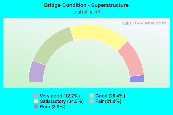
- Bridge Condition - Superstructure
- 12.2%Very good
- 28.4%Good
- 34.5%Satisfactory
- 21.0%Fair
- 3.9%Poor
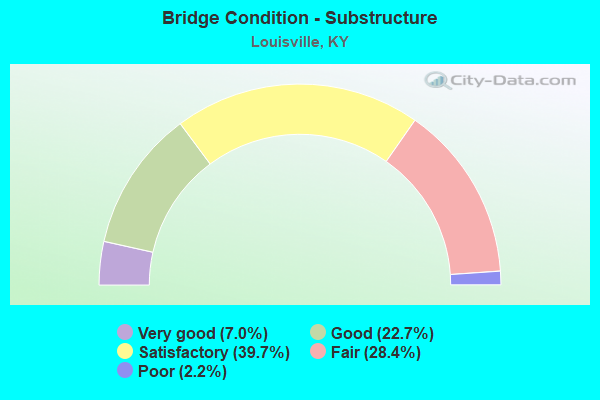
- Bridge Condition - Substructure
- 7.0%Very good
- 22.7%Good
- 39.7%Satisfactory
- 28.4%Fair
- 2.2%Poor
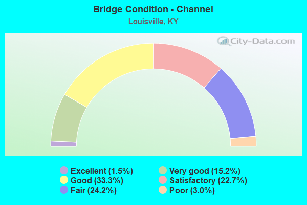
- Bridge Condition - Channel
- 1.5%Excellent
- 15.2%Very good
- 33.3%Good
- 22.7%Satisfactory
- 24.2%Fair
- 3.0%Poor
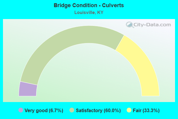
- Bridge Condition - Culverts
- 6.7%Very good
- 60.0%Satisfactory
- 33.3%Fair
Find on map >> Show street view
Structure Number: 56B00420N, Location: 1.8 MI S OF CRTDN NTRCH (Lat: 38.190278, Lng: -85.730278), Route carried "on" structure: Ramp Interstate 65, Year Built: 1989, Status: Open, Structure Length: 10.86m (35.63ft), Average Daily Traffic: 6,449 (year 2018), Average Future Daily Traffic: 6,900 (year 2038), Design Load: HS 20, Features Intersected: I-264 & RAMPS
Minimum Vertical Clearance: 30+ m (98+ ft), Kilometerpoint: 0.050, Lanes on structure: 1, Lanes under structure: 19, Owner: State Highway Agency, Approaching Roadway Width: 8.2m (26.9ft), Skew: 1 degrees, Material/Design: Prestressed concrete continuous, Design/Construction: Stringer/Multi-beam, Number Of Spans In Main Unit: 5, Length of Maximum Span: 22.3m (73.2ft), Curb-To-Curb Width: 8.2m (26.9ft), Out-to-Out Width: 9.2m (30.2ft)
Condition: Deck: Fair, Superstructure: Satisfactory, Substructure: Fair, Operating Rating: 80.2 metric tons, Method Used To Determine Operating Rating: Load Factor (LF), Inventory Rating: 48.2 metric tons, Method Used To Determine Inventory Rating: Load Factor (LF), Structural Evaluation: Somewhat better than minimum adequacy, Deck Geometry: Superior to present desirable criteria, Underclear: Somewhat better than minimum adequacy, Approach Roadway Alignment: Equal to present desirable criteria, Designated Inspection Frequency: Every 24 months, Inspection Date: October 2020, Deck Structure Type: Concrete Cast-file-Place, Wearing Surface/Protective System: Wearing Surface: Monolithic Concrete, Deck Protection: Epoxy Coated Reinforcing
Find on map >> Show street view
Structure Number: 56B00421N, Location: AT I-264 NTRCH (Lat: 38.190278, Lng: -85.730556), Route carried "on" structure: Ramp Interstate 65, Year Built: 1989, Status: Open, Structure Length: 10.86m (35.63ft), Average Daily Traffic: 100,741 (year 2020), Truck Traffic: 11%, Average Future Daily Traffic: 107,792 (year 2040), Design Load: HS 20, Features Intersected: I-264 & RAMPS
Minimum Vertical Clearance: 30+ m (98+ ft), Kilometerpoint: 210.410, Lanes on structure: 1, Lanes under structure: 19, Owner: State Highway Agency, Approaching Roadway Width: 8.2m (26.9ft), Skew: 1 degrees, Material/Design: Prestressed concrete continuous, Design/Construction: Stringer/Multi-beam, Number Of Spans In Main Unit: 5, Length of Maximum Span: 22.3m (73.2ft), Curb-To-Curb Width: 8.2m (26.9ft), Out-to-Out Width: 9.2m (30.2ft)
Condition: Deck: Fair, Superstructure: Satisfactory, Substructure: Fair, Operating Rating: 80.2 metric tons, Method Used To Determine Operating Rating: Load Factor (LF), Inventory Rating: 48.2 metric tons, Method Used To Determine Inventory Rating: Load Factor (LF), Structural Evaluation: Somewhat better than minimum adequacy, Deck Geometry: Superior to present desirable criteria, Underclear: Equal to present minimum criteria, Approach Roadway Alignment: Equal to present desirable criteria, Length Of Structure Improvement: 3.12m (10.24ft), Designated Inspection Frequency: Every 24 months, Inspection Date: October 2020, Bridge Improvement Cost: $11,352,000, Total Project Cost: $11,351,000, Deck Structure Type: Concrete Cast-file-Place, Wearing Surface/Protective System: Wearing Surface: Monolithic Concrete, Deck Protection: Epoxy Coated Reinforcing
Find on map >> Show street view
Structure Number: 56B00422N, Location: 0.15 MI N OF KY 61 (Lat: 38.179167, Lng: -85.719444), Route carried "on" structure: Ramp Interstate 65, Year Built: 1987, Status: Open, Structure Length: 3.36m (11.02ft), Average Daily Traffic: 135,678 (year 2020), Truck Traffic: 15%, Average Future Daily Traffic: 145,175 (year 2040), Design Load: HS 20, Features Intersected: GRADE LN
Minimum Vertical Clearance: 30+ m (98+ ft), Kilometerpoint: 208.857, Lanes on structure: 1, Lanes under structure: 4, Owner: State Highway Agency, Approaching Roadway Width: 7.6m (24.9ft), Skew: 2 degrees, Material/Design: Prestressed concrete, Design/Construction: Stringer/Multi-beam, Number Of Spans In Main Unit: 1, Length of Maximum Span: 32.2m (105.6ft), Curb-To-Curb Width: 7.6m (24.9ft), Out-to-Out Width: 8.6m (28.2ft)
Condition: Deck: Satisfactory, Superstructure: Good, Substructure: Good, Operating Rating: 99.8 metric tons, Method Used To Determine Operating Rating: Load Factor (LF), Inventory Rating: 67.4 metric tons, Method Used To Determine Inventory Rating: Load Factor (LF), Structural Evaluation: Better than present minimum criteria, Deck Geometry: Better than present minimum criteria, Underclear: Somewhat better than minimum adequacy, Approach Roadway Alignment: Equal to present desirable criteria, Designated Inspection Frequency: Every 24 months, Inspection Date: October 2020, Deck Structure Type: Concrete Cast-file-Place, Wearing Surface/Protective System: Wearing Surface: Monolithic Concrete, Deck Protection: Epoxy Coated Reinforcing
Find on map >> Show street view
Structure Number: 56B00423N, Location: 0.2 MI E OF LUCAS AVE (Lat: 38.191667, Lng: -85.715278), Route carried "on" structure: City street 1165, Year Built: 1990, Status: Open, Structure Length: 8.04m (26.38ft), Average Daily Traffic: 916 (year 2006), Average Future Daily Traffic: 1,691 (year 2026), Design Load: HS 20, Features Intersected: CURTIS AVE & NS RR, Facility Carried by Structure: DURRETT LN
Minimum Vertical Clearance: 30+ m (98+ ft), Kilometerpoint: 0.665, Lanes on structure: 2, Lanes under structure: 2, Owner: State Highway Agency, Approaching Roadway Width: 8.5m (27.9ft), Skew: 3 degrees, Material/Design: Prestressed concrete continuous, Design/Construction: Stringer/Multi-beam, Number Of Spans In Main Unit: 4, Length of Maximum Span: 26.2m (86.0ft), Curb-To-Curb Width: 8.5m (27.9ft), Out-to-Out Width: 9.5m (31.2ft)
Condition: Deck: Satisfactory, Superstructure: Satisfactory, Substructure: Satisfactory, Operating Rating: 72.1 metric tons, Method Used To Determine Operating Rating: Load Factor (LF), Inventory Rating: 43.3 metric tons, Method Used To Determine Inventory Rating: Load Factor (LF), Structural Evaluation: Equal to present minimum criteria, Deck Geometry: Somewhat better than minimum adequacy, Underclear: Meets minimum limits, Approach Roadway Alignment: Equal to present desirable criteria, Designated Inspection Frequency: Every 24 months, Inspection Date: June 2020, Deck Structure Type: Concrete Cast-file-Place, Wearing Surface/Protective System: Wearing Surface: Monolithic Concrete, Deck Protection: Epoxy Coated Reinforcing
Find on map >> Show street view
Structure Number: 56B00424L, Location: 0.8 MI E OF I-65 (Lat: 38.191667, Lng: -85.715000), Route carried "on" structure: Interstate 264, Year Built: 1989, Status: Open, Structure Length: 7.73m (25.36ft), Average Daily Traffic: 77,698 (year 2020), Truck Traffic: 9%, Average Future Daily Traffic: 83,136 (year 2040), Design Load: HS 20, Features Intersected: CURTIS AVE & NS RR
Minimum Vertical Clearance: 30+ m (98+ ft), Kilometerpoint: 20.736, Lanes on structure: 5, Lanes under structure: 2, Base Highway Network: Yes, Owner: State Highway Agency, Approaching Roadway Width: 25.4m (83.3ft), Skew: 3 degrees, Material/Design: Prestressed concrete continuous, Design/Construction: Stringer/Multi-beam, Number Of Spans In Main Unit: 4, Length of Maximum Span: 26.1m (85.6ft), Curb-To-Curb Width: 25.4m (83.3ft), Out-to-Out Width: 26.4m (86.6ft)
Condition: Deck: Fair, Superstructure: Fair, Substructure: Satisfactory, Operating Rating: 64.4 metric tons, Method Used To Determine Operating Rating: Load Factor (LF), Inventory Rating: 38.6 metric tons, Method Used To Determine Inventory Rating: Load Factor (LF), Structural Evaluation: Somewhat better than minimum adequacy, Deck Geometry: Better than present minimum criteria, Underclear: Somewhat better than minimum adequacy, Approach Roadway Alignment: Equal to present desirable criteria, Length Of Structure Improvement: 0.77m (2.53ft), Designated Inspection Frequency: Every 24 months, Inspection Date: June 2020, Bridge Improvement Cost: $2,750,000, Total Project Cost: $2,749,000, Deck Structure Type: Concrete Cast-file-Place, Wearing Surface/Protective System: Wearing Surface: Monolithic Concrete, Deck Protection: Epoxy Coated Reinforcing
Find on map >> Show street view
Structure Number: 56B00426L, Location: 1.5 MI W OF I-65 (Lat: 38.190278, Lng: -85.755833), Route carried "on" structure: Interstate 264, Year Built: 1989, Status: Open, Structure Length: 31.38m (102.95ft), Average Daily Traffic: 58,500 (year 2011), Truck Traffic: 8%, Average Future Daily Traffic: 62,595 (year 2031), Design Load: HS 20, Features Intersected: CSX RR & CRITTENDEN DR
Minimum Vertical Clearance: 30+ m (98+ ft), Kilometerpoint: 17.280, Lanes on structure: 4, Lanes under structure: 7, Base Highway Network: Yes, Owner: State Highway Agency, Approaching Roadway Width: 26.0m (85.3ft), Skew: 1 degrees, Material/Design: Prestressed concrete continuous, Design/Construction: Stringer/Multi-beam, Number Of Spans In Main Unit: 12, Length of Maximum Span: 30.5m (100.1ft), Curb-To-Curb Width: 26.0m (85.3ft), Out-to-Out Width: 27.0m (88.6ft)
Condition: Deck: Satisfactory, Superstructure: Satisfactory, Substructure: Satisfactory, Operating Rating: 72.2 metric tons, Method Used To Determine Operating Rating: Load Factor (LF), Inventory Rating: 43.4 metric tons, Method Used To Determine Inventory Rating: Load Factor (LF), Structural Evaluation: Equal to present minimum criteria, Deck Geometry: Superior to present desirable criteria, Underclear: High priority of corrective action, Approach Roadway Alignment: Equal to present desirable criteria, Length Of Structure Improvement: 3.12m (10.24ft), Designated Inspection Frequency: Every 24 months, Inspection Date: January 2021, Bridge Improvement Cost: $9,558,000, Total Project Cost: $9,558,000, Deck Structure Type: Concrete Cast-file-Place, Wearing Surface/Protective System: Wearing Surface: Epoxy Overlay, Deck Protection: Epoxy Coated Reinforcing
Find on map >> Show street view
Structure Number: 56B00427R, Location: 1.5 MI W OF I-65 (Lat: 38.190000, Lng: -85.755833), Route carried "on" structure: Interstate 264, Year Built: 1989, Status: Open, Structure Length: 31.38m (102.95ft), Average Daily Traffic: 58,500 (year 2011), Truck Traffic: 8%, Average Future Daily Traffic: 62,595 (year 2031), Design Load: HS 20, Features Intersected: CSX RR & CRITTENDEN DR
Minimum Vertical Clearance: 30+ m (98+ ft), Kilometerpoint: 17.140, Lanes on structure: 4, Lanes under structure: 7, Base Highway Network: Yes, Owner: State Highway Agency, Approaching Roadway Width: 21.7m (71.2ft), Skew: 1 degrees, Material/Design: Prestressed concrete continuous, Design/Construction: Stringer/Multi-beam, Number Of Spans In Main Unit: 12, Length of Maximum Span: 30.5m (100.1ft), Curb-To-Curb Width: 21.7m (71.2ft), Out-to-Out Width: 22.7m (74.5ft)
Condition: Deck: Fair, Superstructure: Satisfactory, Substructure: Satisfactory, Operating Rating: 52.6 metric tons, Method Used To Determine Operating Rating: Load Factor (LF), Inventory Rating: 31.8 metric tons, Method Used To Determine Inventory Rating: Load Factor (LF), Structural Evaluation: Equal to present minimum criteria, Deck Geometry: Better than present minimum criteria, Underclear: High priority of corrective action, Approach Roadway Alignment: Equal to present desirable criteria, Length Of Structure Improvement: 3.12m (10.24ft), Designated Inspection Frequency: Every 24 months, Inspection Date: January 2021, Bridge Improvement Cost: $11,352,000, Total Project Cost: $11,351,000, Deck Structure Type: Concrete Cast-file-Place, Wearing Surface/Protective System: Wearing Surface: Epoxy Overlay, Deck Protection: Epoxy Coated Reinforcing
Find on map >> Show street view
Structure Number: 56B00429N, Location: 0.2 MI N OF GARDINER LN (Lat: 38.195556, Lng: -85.707500), Route carried "on" structure: State highway 864, Year Built: 1990, Status: Open, Structure Length: 5.92m (19.42ft), Average Daily Traffic: 27,104 (year 2020), Truck Traffic: 7%, Average Future Daily Traffic: 25,206 (year 2040), Design Load: HS 25 or greater, Features Intersected: I-264
Minimum Vertical Clearance: 30+ m (98+ ft), Kilometerpoint: 18.219, Lanes on structure: 4, Lanes under structure: 8, Owner: State Highway Agency, Approaching Roadway Width: 21.9m (71.9ft), Skew: 2 degrees, Material/Design: Steel continuous, Design/Construction: Stringer/Multi-beam, Number Of Spans In Main Unit: 2, Length of Maximum Span: 31.7m (104.0ft), Curb-To-Curb Width: 37.1m (121.7ft), Out-to-Out Width: 38.1m (125.0ft)
Condition: Deck: Fair, Superstructure: Satisfactory, Substructure: Fair, Operating Rating: 67.5 metric tons, Method Used To Determine Operating Rating: Load Factor (LF), Inventory Rating: 40.6 metric tons, Method Used To Determine Inventory Rating: Load Factor (LF), Structural Evaluation: Somewhat better than minimum adequacy, Deck Geometry: Superior to present desirable criteria, Underclear: Equal to present minimum criteria, Approach Roadway Alignment: Equal to present desirable criteria, Designated Inspection Frequency: Every 24 months, Critical Feature Inspection Frequency: Every 24 months, Inspection Date: June 2020, Critical Feature Inspection Date: June 2020, Deck Structure Type: Concrete Cast-file-Place, Wearing Surface/Protective System: Wearing Surface: Monolithic Concrete, Deck Protection: Epoxy Coated Reinforcing
Find on map >> Show street view
Structure Number: 56B00433N, Location: 0.35 MI N OF I-264 NTRCH (Lat: 38.205556, Lng: -85.693056), Route carried "on" structure: State highway 1703, Year Built: 1992, Status: Open, Structure Length: 2.12m (6.96ft), Average Daily Traffic: 13,481 (year 2016), Truck Traffic: 10%, Average Future Daily Traffic: 12,537 (year 2036), Design Load: HS 20, Features Intersected: S FK BEARGRASS CREEK
Minimum Vertical Clearance: 30+ m (98+ ft), Kilometerpoint: 4.200, Lanes on structure: 3, Owner: State Highway Agency, Approaching Roadway Width: 22.6m (74.1ft), Material/Design: Prestressed concrete, Design/Construction: Stringer/Multi-beam, Number Of Spans In Main Unit: 1, Length of Maximum Span: 18.3m (60.0ft), Curb or Sidewalk Widths: Left: 2.4m (7.9ft), Right: 0.0m, Curb-To-Curb Width: 22.6m (74.1ft), Out-to-Out Width: 26.0m (85.3ft)
Condition: Deck: Satisfactory, Superstructure: Good, Substructure: Satisfactory, Channel: Excellent, Operating Rating: 56.8 metric tons, Method Used To Determine Operating Rating: Load Factor (LF), Inventory Rating: 34.1 metric tons, Method Used To Determine Inventory Rating: Load Factor (LF), Structural Evaluation: Equal to present minimum criteria, Deck Geometry: Superior to present desirable criteria, Waterway Adequacy: Superior to present desirable criteria, Approach Roadway Alignment: Equal to present desirable criteria, Designated Inspection Frequency: Every 24 months, Inspection Date: June 2020, Deck Structure Type: Concrete Cast-file-Place, Wearing Surface/Protective System: Wearing Surface: Monolithic Concrete, Deck Protection: Epoxy Coated Reinforcing
Find on map >> Show street view
Structure Number: 56B00434N, Location: 0.65 MI N OF KY 155 (Lat: 38.228333, Lng: -85.636111), Route carried "on" structure: State highway 1932, Year Built: 1992, Status: Open, Structure Length: 8.72m (28.61ft), Average Daily Traffic: 25,816 (year 2020), Truck Traffic: 33%, Average Future Daily Traffic: 24,008 (year 2040), Design Load: HS 25 or greater, Features Intersected: I-264
Minimum Vertical Clearance: 30+ m (98+ ft), Kilometerpoint: 5.642, Lanes on structure: 5, Lanes under structure: 17, Owner: State Highway Agency, Approaching Roadway Width: 26.8m (87.9ft), Skew: 31 degrees, Material/Design: Steel continuous, Design/Construction: Stringer/Multi-beam, Number Of Spans In Main Unit: 2, Length of Maximum Span: 45.9m (150.6ft), Curb-To-Curb Width: 26.8m (87.9ft), Out-to-Out Width: 32.7m (107.3ft)
Condition: Deck: Satisfactory, Superstructure: Good, Substructure: Satisfactory, Operating Rating: 67.0 metric tons, Method Used To Determine Operating Rating: Load Factor (LF), Inventory Rating: 40.2 metric tons, Method Used To Determine Inventory Rating: Load Factor (LF), Structural Evaluation: Equal to present minimum criteria, Deck Geometry: Superior to present desirable criteria, Underclear: Equal to present minimum criteria, Approach Roadway Alignment: Equal to present desirable criteria, Designated Inspection Frequency: Every 24 months, Inspection Date: January 2021, Deck Structure Type: Concrete Cast-file-Place, Wearing Surface/Protective System: Wearing Surface: Monolithic Concrete, Deck Protection: Epoxy Coated Reinforcing
Find on map >> Show street view
Structure Number: 56B00435N, Location: 0.1 MI S OF GARDINER LN (Lat: 38.201944, Lng: -85.688889), Route carried "on" structure: State highway 1703, Year Built: 1993, Status: Open, Structure Length: 9.31m (30.54ft), Average Daily Traffic: 13,481 (year 2016), Truck Traffic: 10%, Average Future Daily Traffic: 12,537 (year 2036), Design Load: HS 20+Mod, Features Intersected: I-264
Minimum Vertical Clearance: 30+ m (98+ ft), Kilometerpoint: 3.636, Lanes on structure: 4, Lanes under structure: 9, Owner: State Highway Agency, Approaching Roadway Width: 28.0m (91.9ft), Skew: 34 degrees, Material/Design: Steel continuous, Design/Construction: Stringer/Multi-beam, Number Of Spans In Main Unit: 2, Length of Maximum Span: 46.4m (152.2ft), Curb-To-Curb Width: 28.0m (91.9ft), Out-to-Out Width: 35.4m (116.1ft)
Condition: Deck: Fair, Superstructure: Good, Substructure: Fair, Operating Rating: 61.3 metric tons, Method Used To Determine Operating Rating: Load Factor (LF), Inventory Rating: 36.8 metric tons, Method Used To Determine Inventory Rating: Load Factor (LF), Structural Evaluation: Somewhat better than minimum adequacy, Deck Geometry: Superior to present desirable criteria, Underclear: Equal to present minimum criteria, Approach Roadway Alignment: Equal to present desirable criteria, Designated Inspection Frequency: Every 24 months, Inspection Date: June 2020, Deck Structure Type: Concrete Cast-file-Place, Wearing Surface/Protective System: Wearing Surface: Monolithic Concrete, Deck Protection: Epoxy Coated Reinforcing
Find on map >> Show street view
Structure Number: 56B00436N, Location: 0.5 MI E OF KY 1703 (Lat: 38.205278, Lng: -85.680833), Route carried "on" structure: Interstate 264, Year Built: 1993, Status: Open, Structure Length: 2.55m (8.37ft), Average Daily Traffic: 124,564 (year 2020), Average Future Daily Traffic: 133,283 (year 2040), Design Load: HS 20+Mod, Features Intersected: S FK BEARGRASS CREEK
Minimum Vertical Clearance: 30+ m (98+ ft), Kilometerpoint: 24.163, Lanes on structure: 9, Base Highway Network: Yes, Owner: State Highway Agency, Approaching Roadway Width: 52.3m (171.6ft), Skew: 32 degrees, Material/Design: Prestressed concrete, Design/Construction: Stringer/Multi-beam, Number Of Spans In Main Unit: 1, Length of Maximum Span: 25.1m (82.3ft), Curb-To-Curb Width: 52.3m (171.6ft), Out-to-Out Width: 54.0m (177.2ft)
Condition: Deck: Fair, Superstructure: Satisfactory, Substructure: Satisfactory, Channel: Satisfactory, Operating Rating: 79.9 metric tons, Method Used To Determine Operating Rating: Load Factor (LF), Inventory Rating: 47.9 metric tons, Method Used To Determine Inventory Rating: Load Factor (LF), Structural Evaluation: Equal to present minimum criteria, Deck Geometry: Superior to present desirable criteria, Waterway Adequacy: Superior to present desirable criteria, Approach Roadway Alignment: Equal to present desirable criteria, Designated Inspection Frequency: Every 24 months, Inspection Date: June 2020, Deck Structure Type: Concrete Cast-file-Place, Wearing Surface/Protective System: Wearing Surface: Monolithic Concrete, Deck Protection: Epoxy Coated Reinforcing
Find on map >> Show street view
Structure Number: 56B00437N, Location: 1.3 MI W OF KY 155 (Lat: 38.211111, Lng: -85.671111), Route carried "on" structure: Interstate 264, Year Built: 1993, Status: Posted for load, Structure Length: 6.74m (22.11ft), Average Daily Traffic: 139,427 (year 2020), Truck Traffic: 9%, Average Future Daily Traffic: 149,186 (year 2040), Design Load: HS 20+Mod, Features Intersected: US 31E (BARDSTOWN RD)
Minimum Vertical Clearance: 30+ m (98+ ft), Kilometerpoint: 25.225, Lanes on structure: 8, Lanes under structure: 6, Base Highway Network: Yes, Owner: State Highway Agency, Approaching Roadway Width: 46.9m (153.9ft), Skew: 30 degrees, Material/Design: Steel, Design/Construction: Stringer/Multi-beam, Number Of Spans In Main Unit: 2, Length of Maximum Span: 55.6m (182.4ft), Curb-To-Curb Width: 44.9m (147.3ft), Out-to-Out Width: 46.7m (153.2ft)
Condition: Deck: Satisfactory, Superstructure: Satisfactory, Substructure: Fair, Operating Rating: 33.5 metric tons, Method Used To Determine Operating Rating: Load Factor (LF), Inventory Rating: 20.0 metric tons, Method Used To Determine Inventory Rating: Load Factor (LF), Structural Evaluation: Somewhat better than minimum adequacy, Deck Geometry: Superior to present desirable criteria, Underclear: Somewhat better than minimum adequacy, Approach Roadway Alignment: Equal to present desirable criteria, Bridge Posting: Required (Relationship of Operating Rating to Maximum Legal Load: 20.0 - 29.9% below), Designated Inspection Frequency: Every 24 months, Critical Feature Inspection Frequency: Every 24 months, Inspection Date: October 2020, Critical Feature Inspection Date: October 2020, Deck Structure Type: Concrete Cast-file-Place, Wearing Surface/Protective System: Wearing Surface: Monolithic Concrete, Deck Protection: Epoxy Coated Reinforcing
Find on map >> Show street view
Structure Number: 56B00438N, Location: 1.3 MI E OF US 31E (Lat: 38.221667, Lng: -85.651111), Route carried "on" structure: Interstate 264, Year Built: 1993, Status: Open, Structure Length: 7.93m (26.02ft), Average Daily Traffic: 163,305 (year 2018), Truck Traffic: 6%, Average Future Daily Traffic: 174,736 (year 2038), Design Load: HS 20+Mod, Features Intersected: KY 155 (TAYLORSVILLE RD)
Minimum Vertical Clearance: 30+ m (98+ ft), Kilometerpoint: 27.336, Lanes on structure: 9, Lanes under structure: 4, Base Highway Network: Yes, Owner: State Highway Agency, Approaching Roadway Width: 50.9m (167.0ft), Skew: 35 degrees, Material/Design: Steel continuous, Design/Construction: Stringer/Multi-beam, Number Of Spans In Main Unit: 2, Length of Maximum Span: 39.7m (130.2ft), Curb-To-Curb Width: 48.6m (159.4ft), Out-to-Out Width: 50.9m (167.0ft)
Condition: Deck: Fair, Superstructure: Good, Substructure: Satisfactory, Operating Rating: 58.2 metric tons, Method Used To Determine Operating Rating: Load Factor (LF), Inventory Rating: 34.9 metric tons, Method Used To Determine Inventory Rating: Load Factor (LF), Structural Evaluation: Equal to present minimum criteria, Deck Geometry: Superior to present desirable criteria, Underclear: Better than present minimum criteria, Approach Roadway Alignment: Equal to present desirable criteria, Designated Inspection Frequency: Every 24 months, Inspection Date: January 2021, Deck Structure Type: Concrete Cast-file-Place, Wearing Surface/Protective System: Wearing Surface: Monolithic Concrete, Deck Protection: Epoxy Coated Reinforcing
Find on map >> Show street view
Structure Number: 56B00439N, Location: 0.7 MI S OF BOWLING BLVD (Lat: 38.233056, Lng: -85.627222), Route carried "on" structure: County highway 1003, Year Built: 1993, Status: Open, Structure Length: 11.78m (38.65ft), Average Daily Traffic: 16,441 (year 2020), Average Future Daily Traffic: 15,290 (year 2040), Design Load: HS 25 or greater, Features Intersected: I-264, Facility Carried by Structure: BROWNS LN
Minimum Vertical Clearance: 30+ m (98+ ft), Kilometerpoint: 2.797, Lanes on structure: 2, Lanes under structure: 10, Owner: State Highway Agency, Approaching Roadway Width: 13.4m (44.0ft), Material/Design: Steel continuous, Design/Construction: Stringer/Multi-beam, Number Of Spans In Main Unit: 4, Length of Maximum Span: 45.4m (149.0ft), Curb-To-Curb Width: 13.4m (44.0ft), Out-to-Out Width: 14.4m (47.2ft)
Condition: Deck: Satisfactory, Superstructure: Good, Substructure: Satisfactory, Operating Rating: 69.6 metric tons, Method Used To Determine Operating Rating: Load Factor (LF), Inventory Rating: 41.7 metric tons, Method Used To Determine Inventory Rating: Load Factor (LF), Structural Evaluation: Equal to present minimum criteria, Deck Geometry: Equal to present minimum criteria, Underclear: High priority of corrective action, Approach Roadway Alignment: Equal to present desirable criteria, Designated Inspection Frequency: Every 24 months, Inspection Date: January 2021, Deck Structure Type: Concrete Cast-file-Place, Wearing Surface/Protective System: Wearing Surface: Epoxy Overlay, Deck Protection: Epoxy Coated Reinforcing
Find on map >> Show street view
Structure Number: 56B00442N, Location: 1.1 MI E OF KY 1932 NTRCH (Lat: 38.239722, Lng: -85.622778), Route carried "on" structure: Ramp Interstate 64, Year Built: 1994, Status: Open, Structure Length: 14.44m (47.38ft), Average Daily Traffic: 91,516 (year 2020), Truck Traffic: 8%, Average Future Daily Traffic: 97,922 (year 2040), Design Load: HS 25 or greater, Features Intersected: I-264 & RAMPS
Minimum Vertical Clearance: 30+ m (98+ ft), Kilometerpoint: 20.086, Lanes on structure: 2, Lanes under structure: 15, Owner: State Highway Agency, Approaching Roadway Width: 10.4m (34.1ft), Material/Design: Steel continuous, Design/Construction: Stringer/Multi-beam, Number Of Spans In Main Unit: 4, Length of Maximum Span: 52.7m (172.9ft), Curb-To-Curb Width: 10.4m (34.1ft), Out-to-Out Width: 11.4m (37.4ft)
Condition: Deck: Good, Superstructure: Good, Substructure: Good, Operating Rating: 72.8 metric tons, Method Used To Determine Operating Rating: Load Factor (LF), Inventory Rating: 43.5 metric tons, Method Used To Determine Inventory Rating: Load Factor (LF), Structural Evaluation: Better than present minimum criteria, Deck Geometry: Better than present minimum criteria, Underclear: Equal to present minimum criteria, Approach Roadway Alignment: Equal to present desirable criteria, Length Of Structure Improvement: 1.44m (4.72ft), Designated Inspection Frequency: Every 24 months, Inspection Date: April 2021, Bridge Improvement Cost: $2,210,000, Total Project Cost: $2,210,000, Deck Structure Type: Concrete Cast-file-Place, Wearing Surface/Protective System: Wearing Surface: Epoxy Overlay, Deck Protection: Epoxy Coated Reinforcing
Find on map >> Show street view
Structure Number: 56B00446L, Location: 0.5 MI E OF BROWNS LN OP (Lat: 38.238056, Lng: -85.623333), Route carried "on" structure: Interstate 64, Year Built: 1994, Status: Open, Structure Length: 13.32m (43.70ft), Average Daily Traffic: 45,758 (year 2020), Truck Traffic: 8%, Average Future Daily Traffic: 48,961 (year 2040), Design Load: HS 25 or greater, Features Intersected: I-264 & RAMPS
Minimum Vertical Clearance: 30+ m (98+ ft), Kilometerpoint: 20.064, Lanes on structure: 2, Lanes under structure: 11, Base Highway Network: Yes, Owner: State Highway Agency, Approaching Roadway Width: 17.4m (57.1ft), Material/Design: Prestressed concrete continuous, Design/Construction: Stringer/Multi-beam, Number Of Spans In Main Unit: 4, Length of Maximum Span: 37.5m (123.0ft), Curb-To-Curb Width: 17.4m (57.1ft), Out-to-Out Width: 18.4m (60.4ft)
Condition: Deck: Good, Superstructure: Satisfactory, Substructure: Satisfactory, Operating Rating: 31.3 metric tons, Method Used To Determine Operating Rating: Load Factor (LF), Inventory Rating: 18.8 metric tons, Method Used To Determine Inventory Rating: Load Factor (LF), Structural Evaluation: Meets minimum limits, Deck Geometry: Superior to present desirable criteria, Underclear: Equal to present minimum criteria, Approach Roadway Alignment: Equal to present desirable criteria, Designated Inspection Frequency: Every 24 months, Inspection Date: April 2021, Deck Structure Type: Concrete Cast-file-Place, Wearing Surface/Protective System: Wearing Surface: Epoxy Overlay, Deck Protection: Epoxy Coated Reinforcing
Find on map >> Show street view
Structure Number: 56B00446R, Location: 1.9 MI E OF KY 2048 NTRCH (Lat: 38.237778, Lng: -85.623333), Route carried "on" structure: Interstate 64, Year Built: 1994, Status: Open, Structure Length: 13.32m (43.70ft), Average Daily Traffic: 45,758 (year 2020), Truck Traffic: 8%, Average Future Daily Traffic: 48,961 (year 2040), Design Load: HS 25 or greater, Features Intersected: I-264 & RAMPS
Minimum Vertical Clearance: 30+ m (98+ ft), Kilometerpoint: 20.064, Lanes on structure: 2, Lanes under structure: 11, Base Highway Network: Yes, Owner: State Highway Agency, Approaching Roadway Width: 31.5m (103.3ft), Skew: 30 degrees, Material/Design: Prestressed concrete continuous, Design/Construction: Stringer/Multi-beam, Number Of Spans In Main Unit: 4, Length of Maximum Span: 37.5m (123.0ft), Curb-To-Curb Width: 31.5m (103.3ft), Out-to-Out Width: 33.3m (109.3ft)
Condition: Deck: Good, Superstructure: Satisfactory, Substructure: Satisfactory, Operating Rating: 30.1 metric tons, Method Used To Determine Operating Rating: Load Factor (LF), Inventory Rating: 18.1 metric tons, Method Used To Determine Inventory Rating: Load Factor (LF), Structural Evaluation: Meets minimum limits, Deck Geometry: Superior to present desirable criteria, Underclear: Equal to present minimum criteria, Approach Roadway Alignment: Equal to present desirable criteria, Designated Inspection Frequency: Every 24 months, Inspection Date: April 2021, Deck Structure Type: Concrete Cast-file-Place, Wearing Surface/Protective System: Wearing Surface: Epoxy Overlay, Deck Protection: Epoxy Coated Reinforcing
Find on map >> Show street view
Structure Number: 56B00447L, Location: 0.9 MI E OF I-64 NTRCH (Lat: 38.250000, Lng: -85.619444), Route carried "on" structure: Interstate 264, Year Built: 1994, Status: Open, Structure Length: 6.39m (20.96ft), Average Daily Traffic: 59,000 (year 2010), Average Future Daily Traffic: 63,130 (year 2030), Design Load: HS 25 or greater, Features Intersected: US 60 (SHELBYVILLE RD)
Minimum Vertical Clearance: 30+ m (98+ ft), Kilometerpoint: 31.780, Lanes on structure: 2, Lanes under structure: 6, Base Highway Network: Yes, Owner: State Highway Agency, Approaching Roadway Width: 15.0m (49.2ft), Material/Design: Prestressed concrete continuous, Design/Construction: Stringer/Multi-beam, Number Of Spans In Main Unit: 2, Length of Maximum Span: 31.2m (102.4ft), Curb-To-Curb Width: 15.0m (49.2ft), Out-to-Out Width: 16.0m (52.5ft)
Condition: Deck: Good, Superstructure: Satisfactory, Substructure: Good, Operating Rating: 95.4 metric tons, Method Used To Determine Operating Rating: Load Factor (LF), Inventory Rating: 57.2 metric tons, Method Used To Determine Inventory Rating: Load Factor (LF), Structural Evaluation: Equal to present minimum criteria, Deck Geometry: Superior to present desirable criteria, Underclear: Superior to present desirable criteria, Approach Roadway Alignment: Equal to present desirable criteria, Designated Inspection Frequency: Every 24 months, Inspection Date: June 2020, Deck Structure Type: Concrete Cast-file-Place, Wearing Surface/Protective System: Wearing Surface: Epoxy Overlay, Deck Protection: Epoxy Coated Reinforcing
Find on map >> Show street view
Structure Number: 56B00447R, Location: 0.9 MI E OF I-64 NTRCH (Lat: 38.250000, Lng: -85.619444), Route carried "on" structure: Interstate 264, Year Built: 1994, Status: Open, Structure Length: 6.39m (20.96ft), Average Future Daily Traffic: 2,034 (year 2034), Design Load: HS 25 or greater, Features Intersected: US 60 (SHELBYVILLE RD)
Minimum Vertical Clearance: 30+ m (98+ ft), Kilometerpoint: 31.818, Lanes on structure: 2, Lanes under structure: 6, Base Highway Network: Yes, Owner: State Highway Agency, Approaching Roadway Width: 15.0m (49.2ft), Material/Design: Prestressed concrete continuous, Design/Construction: Stringer/Multi-beam, Number Of Spans In Main Unit: 2, Length of Maximum Span: 31.2m (102.4ft), Curb-To-Curb Width: 15.0m (49.2ft), Out-to-Out Width: 16.0m (52.5ft)
Condition: Deck: Good, Superstructure: Satisfactory, Substructure: Good, Operating Rating: 95.4 metric tons, Method Used To Determine Operating Rating: Load Factor (LF), Inventory Rating: 57.2 metric tons, Method Used To Determine Inventory Rating: Load Factor (LF), Structural Evaluation: Equal to present minimum criteria, Deck Geometry: Superior to present desirable criteria, Underclear: Superior to present desirable criteria, Approach Roadway Alignment: Equal to present desirable criteria, Designated Inspection Frequency: Every 24 months, Inspection Date: June 2020, Deck Structure Type: Concrete Cast-file-Place, Wearing Surface/Protective System: Wearing Surface: Epoxy Overlay, Deck Protection: Epoxy Coated Reinforcing
Find on map >> Show street view
Structure Number: 56B00448N, Location: 0.9 MI E OF I-64 NTRCH (Lat: 38.250000, Lng: -85.619722), Route carried "on" structure: ServiceInterstate 264, Year Built: 1994, Status: Open, Structure Length: 6.39m (20.96ft), Average Daily Traffic: 48,500 (year 2009), Truck Traffic: 7%, Average Future Daily Traffic: 51,895 (year 2029), Design Load: HS 25 or greater, Features Intersected: US 60 (SHELBYVILLE RD)
Minimum Vertical Clearance: 30+ m (98+ ft), Kilometerpoint: 0.303, Lanes on structure: 2, Lanes under structure: 6, Owner: State Highway Agency, Approaching Roadway Width: 13.4m (44.0ft), Material/Design: Prestressed concrete continuous, Design/Construction: Stringer/Multi-beam, Number Of Spans In Main Unit: 2, Length of Maximum Span: 31.2m (102.4ft), Curb-To-Curb Width: 13.4m (44.0ft), Out-to-Out Width: 14.4m (47.2ft)
Condition: Deck: Good, Superstructure: Satisfactory, Substructure: Satisfactory, Operating Rating: 91.8 metric tons, Method Used To Determine Operating Rating: Load Factor (LF), Inventory Rating: 55.1 metric tons, Method Used To Determine Inventory Rating: Load Factor (LF), Structural Evaluation: Equal to present minimum criteria, Deck Geometry: Equal to present minimum criteria, Underclear: Superior to present desirable criteria, Approach Roadway Alignment: Equal to present desirable criteria, Designated Inspection Frequency: Every 24 months, Inspection Date: June 2020, Deck Structure Type: Concrete Cast-file-Place, Wearing Surface/Protective System: Wearing Surface: Epoxy Overlay, Deck Protection: Epoxy Coated Reinforcing
Find on map >> Show street view
Structure Number: 56B00449N, Location: 0.9 MI E OF I-64 NTRCH (Lat: 38.250000, Lng: -85.619167), Route carried "on" structure: ServiceInterstate 264, Year Built: 1994, Status: Open, Structure Length: 6.39m (20.96ft), Average Daily Traffic: 48,500 (year 2009), Truck Traffic: 7%, Average Future Daily Traffic: 51,895 (year 2029), Design Load: HS 25 or greater, Features Intersected: US 60 (SHELBYVILLE RD)
Minimum Vertical Clearance: 30+ m (98+ ft), Kilometerpoint: 0.422, Lanes on structure: 3, Lanes under structure: 6, Owner: State Highway Agency, Approaching Roadway Width: 17.1m (56.1ft), Material/Design: Prestressed concrete continuous, Design/Construction: Stringer/Multi-beam, Number Of Spans In Main Unit: 2, Length of Maximum Span: 31.2m (102.4ft), Curb-To-Curb Width: 17.1m (56.1ft), Out-to-Out Width: 18.1m (59.4ft)
Condition: Deck: Good, Superstructure: Satisfactory, Substructure: Satisfactory, Operating Rating: 96.2 metric tons, Method Used To Determine Operating Rating: Load Factor (LF), Inventory Rating: 57.7 metric tons, Method Used To Determine Inventory Rating: Load Factor (LF), Structural Evaluation: Equal to present minimum criteria, Deck Geometry: Equal to present minimum criteria, Underclear: Superior to present desirable criteria, Approach Roadway Alignment: Equal to present desirable criteria, Designated Inspection Frequency: Every 24 months, Inspection Date: June 2020, Deck Structure Type: Concrete Cast-file-Place, Wearing Surface/Protective System: Wearing Surface: Epoxy Overlay, Deck Protection: Epoxy Coated Reinforcing
Find on map >> Show street view
Structure Number: 56B00450N, Location: 0.45 MI W OF US 60 (Lat: 38.243889, Lng: -85.621389), Route carried "on" structure: Interstate 264, Year Built: 1994, Status: Open, Structure Length: 2.45m (8.04ft), Average Daily Traffic: 118,000 (year 2010), Average Future Daily Traffic: 126,260 (year 2030), Design Load: HS 25 or greater, Features Intersected: MID FK BEARGRASS CREEK
Minimum Vertical Clearance: 30+ m (98+ ft), Kilometerpoint: 31.121, Lanes on structure: 5, Base Highway Network: Yes, Owner: State Highway Agency, Approaching Roadway Width: 80.4m (263.8ft), Skew: 30 degrees, Material/Design: Prestressed concrete, Design/Construction: Stringer/Multi-beam, Number Of Spans In Main Unit: 1, Length of Maximum Span: 23.8m (78.1ft), Curb-To-Curb Width: 80.4m (263.8ft), Out-to-Out Width: 83.5m (274.0ft)
Condition: Deck: Good, Superstructure: Very good, Substructure: Good, Channel: Good, Operating Rating: 87.2 metric tons, Method Used To Determine Operating Rating: Load Factor (LF), Inventory Rating: 52.3 metric tons, Method Used To Determine Inventory Rating: Load Factor (LF), Structural Evaluation: Better than present minimum criteria, Deck Geometry: Superior to present desirable criteria, Waterway Adequacy: Equal to present desirable criteria, Approach Roadway Alignment: Equal to present desirable criteria, Designated Inspection Frequency: Every 24 months, Inspection Date: January 2021, Deck Structure Type: Concrete Cast-file-Place, Wearing Surface/Protective System: Wearing Surface: Epoxy Overlay, Deck Protection: Epoxy Coated Reinforcing
Find on map >> Show street view
Structure Number: 56B00465N, Location: 0.5 MI E OF BANK ST NTRCH (Lat: 38.265000, Lng: -85.806111), Route carried "on" structure: Interstate 264, Year Built: 2004, Status: Open, Structure Length: 11.05m (36.25ft), Average Daily Traffic: 38,712 (year 2012), Truck Traffic: 10%, Average Future Daily Traffic: 41,421 (year 2032), Design Load: HS 25 or greater, Features Intersected: 34TH ST & DUNCAN ST
Minimum Vertical Clearance: 30+ m (98+ ft), Kilometerpoint: 1.371, Lanes on structure: 6, Lanes under structure: 4, Base Highway Network: Yes, Owner: State Highway Agency, Approaching Roadway Width: 32.1m (105.3ft), Skew: 39 degrees, Material/Design: Prestressed concrete continuous, Design/Construction: Stringer/Multi-beam, Number Of Spans In Main Unit: 5, Length of Maximum Span: 42.7m (140.1ft), Curb-To-Curb Width: 32.1m (105.3ft), Out-to-Out Width: 33.8m (110.9ft)
Condition: Deck: Satisfactory, Superstructure: Good, Substructure: Fair, Operating Rating: 68.0 metric tons, Method Used To Determine Operating Rating: Load Factor (LF), Inventory Rating: 40.8 metric tons, Method Used To Determine Inventory Rating: Load Factor (LF), Structural Evaluation: Somewhat better than minimum adequacy, Deck Geometry: Superior to present desirable criteria, Underclear: Better than present minimum criteria, Approach Roadway Alignment: Equal to present desirable criteria, Designated Inspection Frequency: Every 24 months, Inspection Date: January 2021, Deck Structure Type: Concrete Cast-file-Place, Wearing Surface/Protective System: Wearing Surface: Monolithic Concrete, Deck Protection: Epoxy Coated Reinforcing
Find on map >> Show street view
Structure Number: 56B00466N, Location: 0.3 MI W OF W MUH ALI NTR (Lat: 38.260833, Lng: -85.805000), Route carried "on" structure: Interstate 264, Year Built: 2004, Status: Open, Structure Length: 2.02m (6.63ft), Average Daily Traffic: 38,712 (year 2012), Truck Traffic: 10%, Average Future Daily Traffic: 41,421 (year 2032), Design Load: HS 25 or greater, Features Intersected: US 31E (W MARKET ST)
Minimum Vertical Clearance: 30+ m (98+ ft), Kilometerpoint: 1.868, Lanes on structure: 6, Lanes under structure: 2, Base Highway Network: Yes, Owner: State Highway Agency, Approaching Roadway Width: 35.5m (116.5ft), Skew: 30 degrees, Material/Design: Prestressed concrete, Design/Construction: Box Beam or Girders - Single/Spread, Number Of Spans In Main Unit: 1, Length of Maximum Span: 18.9m (62.0ft), Curb-To-Curb Width: 35.5m (116.5ft), Out-to-Out Width: 37.2m (122.0ft)
Condition: Deck: Good, Superstructure: Good, Substructure: Satisfactory, Operating Rating: 83.5 metric tons, Method Used To Determine Operating Rating: Load Factor (LF), Inventory Rating: 50.1 metric tons, Method Used To Determine Inventory Rating: Load Factor (LF), Structural Evaluation: Equal to present minimum criteria, Deck Geometry: Superior to present desirable criteria, Underclear: Meets minimum limits, Approach Roadway Alignment: Equal to present desirable criteria, Designated Inspection Frequency: Every 24 months, Inspection Date: January 2021, Deck Structure Type: Concrete Cast-file-Place, Wearing Surface/Protective System: Wearing Surface: Monolithic Concrete, Deck Protection: Epoxy Coated Reinforcing
Find on map >> Show street view
Structure Number: 56B00467N, Location: 0.16 MI W OF RIVER PK NTR (Lat: 38.256389, Lng: -85.805556), Route carried "on" structure: Interstate 264, Year Built: 2004, Status: Open, Structure Length: 2.08m (6.82ft), Average Daily Traffic: 38,712 (year 2012), Truck Traffic: 10%, Average Future Daily Traffic: 41,421 (year 2032), Design Load: HS 25 or greater, Features Intersected: W MUHAMMAD ALI BLVD
Minimum Vertical Clearance: 30+ m (98+ ft), Kilometerpoint: 2.342, Lanes on structure: 6, Lanes under structure: 2, Base Highway Network: Yes, Owner: State Highway Agency, Approaching Roadway Width: 32.2m (105.6ft), Skew: 30 degrees, Material/Design: Prestressed concrete, Design/Construction: Stringer/Multi-beam, Number Of Spans In Main Unit: 1, Length of Maximum Span: 19.4m (63.6ft), Curb-To-Curb Width: 32.2m (105.6ft), Out-to-Out Width: 33.9m (111.2ft)
Condition: Deck: Good, Superstructure: Good, Substructure: Satisfactory, Operating Rating: 72.7 metric tons, Method Used To Determine Operating Rating: Load Factor (LF), Inventory Rating: 43.6 metric tons, Method Used To Determine Inventory Rating: Load Factor (LF), Structural Evaluation: Equal to present minimum criteria, Deck Geometry: Superior to present desirable criteria, Underclear: Equal to present minimum criteria, Approach Roadway Alignment: Equal to present desirable criteria, Designated Inspection Frequency: Every 24 months, Inspection Date: January 2021, Deck Structure Type: Concrete Cast-file-Place, Wearing Surface/Protective System: Wearing Surface: Monolithic Concrete, Deck Protection: Epoxy Coated Reinforcing
Find on map >> Show street view
Structure Number: 56B00468N, Location: 0.1 MI E OF MUH ALI NTRCH (Lat: 38.255278, Lng: -85.805556), Route carried "on" structure: Interstate 264, Year Built: 2003, Status: Open, Structure Length: 2.05m (6.73ft), Average Daily Traffic: 38,712 (year 2012), Truck Traffic: 10%, Average Future Daily Traffic: 41,421 (year 2032), Design Load: HS 25 or greater, Features Intersected: VERMONT AVE
Minimum Vertical Clearance: 30+ m (98+ ft), Kilometerpoint: 2.467, Lanes on structure: 6, Lanes under structure: 2, Base Highway Network: Yes, Owner: State Highway Agency, Approaching Roadway Width: 32.2m (105.6ft), Skew: 30 degrees, Material/Design: Prestressed concrete, Design/Construction: Box Beam or Girders - Single/Spread, Number Of Spans In Main Unit: 1, Length of Maximum Span: 19.1m (62.7ft), Curb-To-Curb Width: 32.2m (105.6ft), Out-to-Out Width: 33.9m (111.2ft)
Condition: Deck: Good, Superstructure: Good, Substructure: Satisfactory, Operating Rating: 90.3 metric tons, Method Used To Determine Operating Rating: Load Factor (LF), Inventory Rating: 54.2 metric tons, Method Used To Determine Inventory Rating: Load Factor (LF), Structural Evaluation: Equal to present minimum criteria, Deck Geometry: Superior to present desirable criteria, Underclear: Better than present minimum criteria, Approach Roadway Alignment: Equal to present desirable criteria, Designated Inspection Frequency: Every 24 months, Inspection Date: January 2021, Deck Structure Type: Concrete Cast-file-Place, Wearing Surface/Protective System: Wearing Surface: Monolithic Concrete, Deck Protection: Epoxy Coated Reinforcing
Find on map >> Show street view
Structure Number: 56B00469N, Location: 0.15 MI E OF MUH ALI NTRC (Lat: 38.254167, Lng: -85.805833), Route carried "on" structure: Interstate 264, Year Built: 2003, Status: Open, Structure Length: 2.15m (7.05ft), Average Daily Traffic: 52,015 (year 2020), Truck Traffic: 8%, Average Future Daily Traffic: 55,656 (year 2040), Design Load: HS 25 or greater, Features Intersected: RIVER PARK DR
Minimum Vertical Clearance: 30+ m (98+ ft), Kilometerpoint: 2.588, Lanes on structure: 6, Lanes under structure: 2, Base Highway Network: Yes, Owner: State Highway Agency, Approaching Roadway Width: 32.2m (105.6ft), Skew: 30 degrees, Material/Design: Prestressed concrete, Design/Construction: Stringer/Multi-beam, Number Of Spans In Main Unit: 1, Length of Maximum Span: 20.1m (65.9ft), Curb-To-Curb Width: 32.2m (105.6ft), Out-to-Out Width: 33.9m (111.2ft)
Condition: Deck: Good, Superstructure: Good, Substructure: Satisfactory, Operating Rating: 83.4 metric tons, Method Used To Determine Operating Rating: Load Factor (LF), Inventory Rating: 50.0 metric tons, Method Used To Determine Inventory Rating: Load Factor (LF), Structural Evaluation: Equal to present minimum criteria, Deck Geometry: Superior to present desirable criteria, Underclear: Equal to present minimum criteria, Approach Roadway Alignment: Equal to present desirable criteria, Designated Inspection Frequency: Every 24 months, Inspection Date: January 2021, Deck Structure Type: Concrete Cast-file-Place, Wearing Surface/Protective System: Wearing Surface: Monolithic Concrete, Deck Protection: Epoxy Coated Reinforcing
Find on map >> Show street view
Structure Number: 56B00470N, Location: 0.8 MI W OF VIRGINIA AVE (Lat: 38.249722, Lng: -85.806944), Route carried "on" structure: Interstate 264, Year Built: 2003, Status: Open, Structure Length: 3.08m (10.10ft), Average Daily Traffic: 52,015 (year 2020), Truck Traffic: 8%, Average Future Daily Traffic: 55,656 (year 2040), Design Load: HS 25 or greater, Features Intersected: US 150 (W BROADWAY)
Minimum Vertical Clearance: 30+ m (98+ ft), Kilometerpoint: 3.092, Lanes on structure: 6, Lanes under structure: 3, Base Highway Network: Yes, Owner: State Highway Agency, Approaching Roadway Width: 34.6m (113.5ft), Skew: 31 degrees, Material/Design: Prestressed concrete, Design/Construction: Stringer/Multi-beam, Number Of Spans In Main Unit: 1, Length of Maximum Span: 29.5m (96.8ft), Curb-To-Curb Width: 34.6m (113.5ft), Out-to-Out Width: 36.3m (119.1ft)
Condition: Deck: Good, Superstructure: Good, Substructure: Satisfactory, Operating Rating: 99.8 metric tons, Method Used To Determine Operating Rating: Load Factor (LF), Inventory Rating: 67.7 metric tons, Method Used To Determine Inventory Rating: Load Factor (LF), Structural Evaluation: Equal to present minimum criteria, Deck Geometry: Superior to present desirable criteria, Underclear: Equal to present minimum criteria, Approach Roadway Alignment: Equal to present desirable criteria, Designated Inspection Frequency: Every 24 months, Inspection Date: January 2021, Deck Structure Type: Concrete Cast-file-Place, Wearing Surface/Protective System: Wearing Surface: Monolithic Concrete, Deck Protection: Epoxy Coated Reinforcing
Find on map >> Show street view
Structure Number: 56B00471N, Location: 0.65 MI W OF VIRGINIA AVE (Lat: 38.247778, Lng: -85.808611), Route carried "on" structure: Interstate 264, Year Built: 2003, Status: Open, Structure Length: 2.71m (8.89ft), Average Daily Traffic: 52,015 (year 2020), Truck Traffic: 8%, Average Future Daily Traffic: 55,656 (year 2040), Design Load: HS 25 or greater, Features Intersected: 34TH ST
Minimum Vertical Clearance: 30+ m (98+ ft), Kilometerpoint: 3.351, Lanes on structure: 6, Lanes under structure: 2, Base Highway Network: Yes, Owner: State Highway Agency, Approaching Roadway Width: 32.5m (106.6ft), Skew: 34 degrees, Material/Design: Prestressed concrete, Design/Construction: Stringer/Multi-beam, Number Of Spans In Main Unit: 1, Length of Maximum Span: 24.7m (81.0ft), Curb-To-Curb Width: 32.5m (106.6ft), Out-to-Out Width: 34.2m (112.2ft)
Condition: Deck: Good, Superstructure: Good, Substructure: Satisfactory, Operating Rating: 99.8 metric tons, Method Used To Determine Operating Rating: Load Factor (LF), Inventory Rating: 60.3 metric tons, Method Used To Determine Inventory Rating: Load Factor (LF), Structural Evaluation: Equal to present minimum criteria, Deck Geometry: Superior to present desirable criteria, Underclear: Better than present minimum criteria, Approach Roadway Alignment: Equal to present desirable criteria, Designated Inspection Frequency: Every 24 months, Inspection Date: January 2021, Deck Structure Type: Concrete Cast-file-Place, Wearing Surface/Protective System: Wearing Surface: Monolithic Concrete, Deck Protection: Epoxy Coated Reinforcing
Find on map >> Show street view
Structure Number: 56B00472N, Location: 0.5 MI W OF VIRGINIA AVE (Lat: 38.246111, Lng: -85.810833), Route carried "on" structure: Interstate 264, Year Built: 2003, Status: Open, Structure Length: 2.79m (9.15ft), Average Daily Traffic: 52,015 (year 2020), Truck Traffic: 8%, Average Future Daily Traffic: 55,656 (year 2040), Design Load: HS 25 or greater, Features Intersected: GARLAND AVE
Minimum Vertical Clearance: 30+ m (98+ ft), Kilometerpoint: 3.639, Lanes on structure: 6, Lanes under structure: 2, Base Highway Network: Yes, Owner: State Highway Agency, Approaching Roadway Width: 32.2m (105.6ft), Skew: 33 degrees, Material/Design: Prestressed concrete, Design/Construction: Stringer/Multi-beam, Number Of Spans In Main Unit: 1, Length of Maximum Span: 26.1m (85.6ft), Curb-To-Curb Width: 32.2m (105.6ft), Out-to-Out Width: 33.9m (111.2ft)
Condition: Deck: Good, Superstructure: Good, Substructure: Satisfactory, Operating Rating: 99.8 metric tons, Method Used To Determine Operating Rating: Load Factor (LF), Inventory Rating: 64.4 metric tons, Method Used To Determine Inventory Rating: Load Factor (LF), Structural Evaluation: Equal to present minimum criteria, Deck Geometry: Superior to present desirable criteria, Underclear: Equal to present minimum criteria, Approach Roadway Alignment: Equal to present desirable criteria, Designated Inspection Frequency: Every 24 months, Inspection Date: January 2021, Deck Structure Type: Concrete Cast-file-Place, Wearing Surface/Protective System: Wearing Surface: Monolithic Concrete, Deck Protection: Epoxy Coated Reinforcing
Find on map >> Show street view
Structure Number: 56B00473N, Location: 0.25 MI W OF VIRGINIA AVE (Lat: 38.243611, Lng: -85.813611), Route carried "on" structure: Interstate 264, Year Built: 2003, Status: Open, Structure Length: 2.29m (7.51ft), Average Daily Traffic: 52,015 (year 2020), Truck Traffic: 8%, Average Future Daily Traffic: 55,656 (year 2040), Design Load: HS 25 or greater, Features Intersected: GREENWOOD AVE
Minimum Vertical Clearance: 30+ m (98+ ft), Kilometerpoint: 4.002, Lanes on structure: 6, Lanes under structure: 2, Base Highway Network: Yes, Owner: State Highway Agency, Approaching Roadway Width: 34.6m (113.5ft), Skew: 32 degrees, Material/Design: Prestressed concrete, Design/Construction: Stringer/Multi-beam, Number Of Spans In Main Unit: 1, Length of Maximum Span: 21.3m (69.9ft), Curb-To-Curb Width: 33.6m (110.2ft), Out-to-Out Width: 35.3m (115.8ft)
Condition: Deck: Good, Superstructure: Good, Substructure: Satisfactory, Operating Rating: 92.0 metric tons, Method Used To Determine Operating Rating: Load Factor (LF), Inventory Rating: 55.2 metric tons, Method Used To Determine Inventory Rating: Load Factor (LF), Structural Evaluation: Equal to present minimum criteria, Deck Geometry: Superior to present desirable criteria, Underclear: Better than present minimum criteria, Approach Roadway Alignment: Equal to present desirable criteria, Designated Inspection Frequency: Every 24 months, Inspection Date: January 2021, Deck Structure Type: Concrete Cast-file-Place, Wearing Surface/Protective System: Wearing Surface: Monolithic Concrete, Deck Protection: Epoxy Coated Reinforcing
Find on map >> Show street view
Structure Number: 56B00474N, Location: 0.15 MI W OF DUMESNIL ST (Lat: 38.240278, Lng: -85.815556), Route carried "on" structure: Interstate 264, Year Built: 2003, Status: Open, Structure Length: 5.79m (19.00ft), Average Daily Traffic: 59,179 (year 2020), Average Future Daily Traffic: 63,321 (year 2040), Design Load: HS 25 or greater, Features Intersected: VIRGINIA AVE
Minimum Vertical Clearance: 30+ m (98+ ft), Kilometerpoint: 4.405, Lanes on structure: 6, Lanes under structure: 2, Base Highway Network: Yes, Owner: State Highway Agency, Approaching Roadway Width: 32.1m (105.3ft), Skew: 33 degrees, Material/Design: Prestressed concrete continuous, Design/Construction: Stringer/Multi-beam, Number Of Spans In Main Unit: 3, Length of Maximum Span: 25.0m (82.0ft), Curb-To-Curb Width: 32.1m (105.3ft), Out-to-Out Width: 33.8m (110.9ft)
Condition: Deck: Satisfactory, Superstructure: Satisfactory, Substructure: Satisfactory, Operating Rating: 76.8 metric tons, Method Used To Determine Operating Rating: Load Factor (LF), Inventory Rating: 46.1 metric tons, Method Used To Determine Inventory Rating: Load Factor (LF), Structural Evaluation: Equal to present minimum criteria, Deck Geometry: Superior to present desirable criteria, Underclear: Equal to present minimum criteria, Approach Roadway Alignment: Equal to present desirable criteria, Designated Inspection Frequency: Every 24 months, Inspection Date: January 2021, Deck Structure Type: Concrete Cast-file-Place, Wearing Surface/Protective System: Wearing Surface: Monolithic Concrete, Deck Protection: Epoxy Coated Reinforcing
Find on map >> Show street view
Structure Number: 56B00475N, Location: 1.1 MI W OF KY 2056 NTRCH (Lat: 38.238333, Lng: -85.816667), Route carried "on" structure: Interstate 264, Year Built: 2003, Status: Open, Structure Length: 4.95m (16.24ft), Average Daily Traffic: 59,179 (year 2020), Average Future Daily Traffic: 63,321 (year 2040), Design Load: HS 25 or greater, Features Intersected: DUMESNIL ST
Minimum Vertical Clearance: 30+ m (98+ ft), Kilometerpoint: 4.651, Lanes on structure: 6, Lanes under structure: 2, Base Highway Network: Yes, Owner: State Highway Agency, Approaching Roadway Width: 32.2m (105.6ft), Skew: 30 degrees, Material/Design: Prestressed concrete continuous, Design/Construction: Stringer/Multi-beam, Number Of Spans In Main Unit: 3, Length of Maximum Span: 25.6m (84.0ft), Curb-To-Curb Width: 32.2m (105.6ft), Out-to-Out Width: 33.9m (111.2ft)
Condition: Deck: Satisfactory, Superstructure: Good, Substructure: Fair, Operating Rating: 65.0 metric tons, Method Used To Determine Operating Rating: Load Factor (LF), Inventory Rating: 39.0 metric tons, Method Used To Determine Inventory Rating: Load Factor (LF), Structural Evaluation: Somewhat better than minimum adequacy, Deck Geometry: Superior to present desirable criteria, Underclear: Somewhat better than minimum adequacy, Approach Roadway Alignment: Equal to present desirable criteria, Designated Inspection Frequency: Every 24 months, Inspection Date: January 2021, Deck Structure Type: Concrete Cast-file-Place, Wearing Surface/Protective System: Wearing Surface: Monolithic Concrete, Deck Protection: Epoxy Coated Reinforcing
Find on map >> Show street view
Structure Number: 56B00476N, Location: 0.5 MI E OF DUMESNIL NTRC (Lat: 38.232500, Lng: -85.820278), Route carried "on" structure: Interstate 264, Year Built: 2003, Status: Open, Structure Length: 8.50m (27.89ft), Average Daily Traffic: 59,179 (year 2020), Average Future Daily Traffic: 63,321 (year 2040), Design Load: HS 25 or greater, Features Intersected: GIBSON LN & NS RAILROAD
Minimum Vertical Clearance: 30+ m (98+ ft), Kilometerpoint: 5.366, Lanes on structure: 6, Lanes under structure: 1, Base Highway Network: Yes, Owner: State Highway Agency, Approaching Roadway Width: 32.2m (105.6ft), Skew: 32 degrees, Material/Design: Prestressed concrete continuous, Design/Construction: Stringer/Multi-beam, Number Of Spans In Main Unit: 4, Length of Maximum Span: 26.2m (86.0ft), Curb-To-Curb Width: 32.2m (105.6ft), Out-to-Out Width: 33.9m (111.2ft)
Condition: Deck: Satisfactory, Superstructure: Satisfactory, Substructure: Fair, Operating Rating: 64.8 metric tons, Method Used To Determine Operating Rating: Load Factor (LF), Inventory Rating: 38.8 metric tons, Method Used To Determine Inventory Rating: Load Factor (LF), Structural Evaluation: Somewhat better than minimum adequacy, Deck Geometry: Superior to present desirable criteria, Underclear: Somewhat better than minimum adequacy, Approach Roadway Alignment: Equal to present desirable criteria, Designated Inspection Frequency: Every 24 months, Inspection Date: January 2021, Deck Structure Type: Concrete Cast-file-Place, Wearing Surface/Protective System: Wearing Surface: Monolithic Concrete, Deck Protection: Epoxy Coated Reinforcing
Find on map >> Show street view
Structure Number: 56B00477N, Location: 0.2 MI W OF KY 2056 NTRCH (Lat: 38.225833, Lng: -85.821944), Route carried "on" structure: Interstate 264, Year Built: 2003, Status: Open, Structure Length: 2.86m (9.38ft), Average Daily Traffic: 59,179 (year 2020), Average Future Daily Traffic: 63,321 (year 2040), Design Load: HS 25 or greater, Features Intersected: KY 2054 (ALGONQUIN PKWY)
Minimum Vertical Clearance: 30+ m (98+ ft), Kilometerpoint: 6.127, Lanes on structure: 6, Lanes under structure: 3, Base Highway Network: Yes, Owner: State Highway Agency, Approaching Roadway Width: 43.9m (144.0ft), Skew: 30 degrees, Material/Design: Prestressed concrete, Design/Construction: Stringer/Multi-beam, Number Of Spans In Main Unit: 1, Length of Maximum Span: 27.8m (91.2ft), Curb-To-Curb Width: 43.9m (144.0ft), Out-to-Out Width: 45.6m (149.6ft)
Condition: Deck: Good, Superstructure: Good, Substructure: Satisfactory, Operating Rating: 95.1 metric tons, Method Used To Determine Operating Rating: Load Factor (LF), Inventory Rating: 57.1 metric tons, Method Used To Determine Inventory Rating: Load Factor (LF), Structural Evaluation: Equal to present minimum criteria, Deck Geometry: Superior to present desirable criteria, Underclear: Equal to present minimum criteria, Approach Roadway Alignment: Equal to present desirable criteria, Designated Inspection Frequency: Every 24 months, Inspection Date: January 2021, Deck Structure Type: Concrete Cast-file-Place, Wearing Surface/Protective System: Wearing Surface: Monolithic Concrete, Deck Protection: Epoxy Coated Reinforcing
Find on map >> Show street view
Structure Number: 56B00496L, Location: 1.6 MI W OF RIVER PARK DR (Lat: 38.275278, Lng: -85.810000), Route carried "on" structure: Interstate 264, Year Built: 2010, Status: Open, Structure Length: 25.29m (82.97ft), Average Daily Traffic: 24,250 (year 2009), Truck Traffic: 7%, Average Future Daily Traffic: 25,948 (year 2029), Design Load: Greater than HL93, Features Intersected: I-64 EB, RAMP & KY 3064
Minimum Vertical Clearance: 30+ m (98+ ft), Kilometerpoint: 0.206, Lanes on structure: 1, Lanes under structure: 9, Base Highway Network: Yes, Owner: State Highway Agency, Approaching Roadway Width: 11.6m (38.1ft), Skew: 9 degrees, Material/Design: Prestressed concrete continuous, Design/Construction: Stringer/Multi-beam, Number Of Spans In Main Unit: 9, Length of Maximum Span: 38.8m (127.3ft), Curb-To-Curb Width: 11.6m (38.1ft), Out-to-Out Width: 12.5m (41.0ft)
Condition: Deck: Satisfactory, Superstructure: Good, Substructure: Good, Operating Rating: 39.2 metric tons, Method Used To Determine Operating Rating: Load and Resistance Factor Rating (LRFR) rating reported by rating factor(RF) method using HL-93 loadings, Inventory Rating: 31.1 metric tons, Method Used To Determine Inventory Rating: Load and Resistance Factor Rating (LRFR) rating reported by rating factor(RF) method using HL-93 loadings, Structural Evaluation: Better than present minimum criteria, Deck Geometry: Somewhat better than minimum adequacy, Underclear: Somewhat better than minimum adequacy, Approach Roadway Alignment: Equal to present desirable criteria, Designated Inspection Frequency: Every 24 months, Inspection Date: June 2021, Deck Structure Type: Concrete Cast-file-Place, Wearing Surface/Protective System: Wearing Surface: Monolithic Concrete, Deck Protection: Epoxy Coated Reinforcing
Find on map >> Show street view
Structure Number: 56B00499N, Location: 0.25 MI E OF US 31E (Lat: 38.253333, Lng: -85.727500), Route carried "on" structure: US 42, Year Built: 2014, Status: Open, Structure Length: 1.68m (5.51ft), Average Daily Traffic: 5,800 (year 2020), Truck Traffic: 25%, Average Future Daily Traffic: 5,452 (year 2040), Design Load: Greater than HL93, Features Intersected: BEARGRASS CREEK
Minimum Vertical Clearance: 30+ m (98+ ft), Kilometerpoint: 0.418, Lanes on structure: 3, Base Highway Network: Yes, Owner: State Highway Agency, Approaching Roadway Width: 12.2m (40.0ft), Material/Design: Prestressed concrete, Design/Construction: Stringer/Multi-beam, Number Of Spans In Main Unit: 1, Length of Maximum Span: 16.2m (53.1ft), Curb or Sidewalk Widths: Left: 2.2m (7.2ft), Right: 2.2m (7.2ft), Curb-To-Curb Width: 12.2m (40.0ft), Out-to-Out Width: 17.5m (57.4ft)
Condition: Deck: Good, Superstructure: Very good, Substructure: Fair, Channel: Good, Operating Rating: 95.3 metric tons, Method Used To Determine Operating Rating: Load and Resistance Factor Rating (LRFR) rating reported by rating factor(RF) method using HL-93 loadings, Inventory Rating: 73.5 metric tons, Method Used To Determine Inventory Rating: Load and Resistance Factor Rating (LRFR) rating reported by rating factor(RF) method using HL-93 loadings, Structural Evaluation: Somewhat better than minimum adequacy, Deck Geometry: Meets minimum limits, Waterway Adequacy: Equal to present desirable criteria, Approach Roadway Alignment: Equal to present desirable criteria, Designated Inspection Frequency: Every 24 months, Inspection Date: November 2021, Deck Structure Type: Concrete Cast-file-Place, Wearing Surface/Protective System: Wearing Surface: Monolithic Concrete, Deck Protection: Epoxy Coated Reinforcing
Find on map >> Show street view
Structure Number: 56B00526R, Location: AT KY/IN STATE LINE (Lat: 38.264722, Lng: -85.742778), Route carried "on" structure: Interstate 65, Year Built: 2016, Status: Open, Structure Length: 64.19m (210.60ft), Average Daily Traffic: 60,500 (year 2008), Truck Traffic: 15%, Average Future Daily Traffic: 64,735 (year 2028), Design Load: Greater than HL93, Features Intersected: OHIO RIVER
Minimum Vertical Clearance: 30+ m (98+ ft), Kilometerpoint: 220.290, Lanes on structure: 6, Base Highway Network: Yes, Owner: State Highway Agency, Maintenance Responsibility: State Toll Authority, Approaching Roadway Width: 29.3m (96.1ft), Navigation Control: Yes ( Vertical Clearance: 21.6m (70.9ft), Horizontal Clearance: 141.7m (464.9ft)), Material/Design: Steel continuous, Design/Construction: Stayed Girder, Number Of Spans In Main Unit: 4, Length of Maximum Span: 228.6m (750.0ft), Curb-To-Curb Width: 29.3m (96.1ft), Out-to-Out Width: 30.8m (101.0ft)
Condition: Deck: Good, Superstructure: Good, Substructure: Good, Channel: Good, Operating Rating: 43.1 metric tons, Method Used To Determine Operating Rating: Load and Resistance Factor Rating (LRFR) rating reported by rating factor(RF) method using HL-93 loadings, Inventory Rating: 33.0 metric tons, Method Used To Determine Inventory Rating: Load and Resistance Factor Rating (LRFR) rating reported by rating factor(RF) method using HL-93 loadings, Structural Evaluation: Better than present minimum criteria, Deck Geometry: Better than present minimum criteria, Waterway Adequacy: Superior to present desirable criteria, Approach Roadway Alignment: Superior to present desirable criteria, Designated Inspection Frequency: Every 24 months, Critical Feature Inspection Frequency: Every 24 months, Underwater Inspection Frequency: Every 60 months, Inspection Date: September 2020, Critical Feature Inspection Date: September 2020, Underwater Inspection Date: August 2019, Deck Structure Type: Concrete Precast Panels, Wearing Surface/Protective System: Wearing Surface: Bituminous, Membrane: Other, Deck Protection: Epoxy Coated Reinforcing