Bridge Statistics for Louisville, Kentucky (KY)
Condition, Traffic, Stress, Structural Evaluation, Project Costs
- National Bridge Inventory (NBI) Statistics
- 581Number of bridges
- 8,465ft / 2,580mTotal length
- $406,474,000Total costs
- 25,145,399Total average daily traffic
- 2,218,311Total average daily truck traffic
- National Bridge Inventory (NBI) Registered Bridges for Louisville
- No street view available for this location
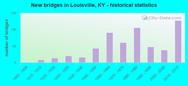
- New bridges - historical statistics
- 21900-1909
- 91910-1919
- 141920-1929
- 211930-1939
- 171940-1949
- 441950-1959
- 921960-1969
- 611970-1979
- 1061980-1989
- 481990-1999
- 382000-2009
- 1282010-2019
- 12020-2022
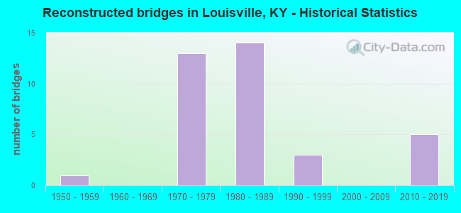
- Reconstructed bridges - Historical Statistics
- 11950-1959
- 01960-1969
- 131970-1979
- 141980-1989
- 31990-1999
- 02000-2009
- 52010-2019
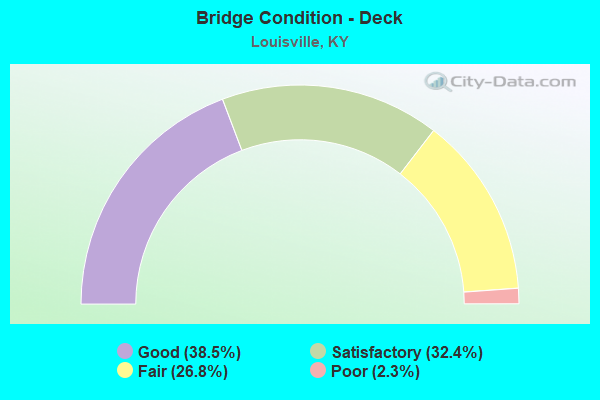
- Bridge Condition - Deck
- 38.5%Good
- 32.4%Satisfactory
- 26.8%Fair
- 2.3%Poor
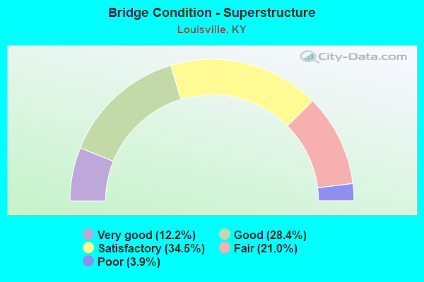
- Bridge Condition - Superstructure
- 12.2%Very good
- 28.4%Good
- 34.5%Satisfactory
- 21.0%Fair
- 3.9%Poor
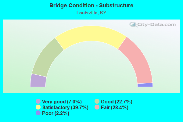
- Bridge Condition - Substructure
- 7.0%Very good
- 22.7%Good
- 39.7%Satisfactory
- 28.4%Fair
- 2.2%Poor
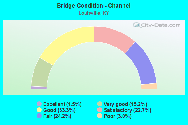
- Bridge Condition - Channel
- 1.5%Excellent
- 15.2%Very good
- 33.3%Good
- 22.7%Satisfactory
- 24.2%Fair
- 3.0%Poor
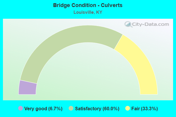
- Bridge Condition - Culverts
- 6.7%Very good
- 60.0%Satisfactory
- 33.3%Fair
Find on map >> Show street view
Structure Number: 56B00283N, Location: 0.9 MI E OF I-264 NTRCH (Lat: 38.275278, Lng: -85.790833), Route carried "on" structure: Interstate 64, Year Built: 1970, Status: Open, Structure Length: 31.09m (102.00ft), Average Daily Traffic: 65,180 (year 2017), Truck Traffic: 9%, Average Future Daily Traffic: 69,742 (year 2037), Design Load: HS 20, Features Intersected: NS RR, 27TH ST & LANNAN
Minimum Vertical Clearance: 30+ m (98+ ft), Kilometerpoint: 3.397, Lanes on structure: 6, Lanes under structure: 4, Base Highway Network: Yes, Owner: State Highway Agency, Approaching Roadway Width: 27.0m (88.6ft), Skew: 30 degrees, Material/Design: Steel continuous, Design/Construction: Stringer/Multi-beam, Number Of Spans In Main Unit: 12, Length of Maximum Span: 40.5m (132.9ft), Curb-To-Curb Width: 27.0m (88.6ft), Out-to-Out Width: 28.7m (94.2ft)
Condition: Deck: Good, Superstructure: Satisfactory, Substructure: Satisfactory, Operating Rating: 12.0 metric tons, Method Used To Determine Operating Rating: Load and Resistance Factor Rating (LRFR) rating reported by rating factor(RF) method using HL-93 loadings, Inventory Rating: 9.4 metric tons, Method Used To Determine Inventory Rating: Load and Resistance Factor Rating (LRFR) rating reported by rating factor(RF) method using HL-93 loadings, Structural Evaluation: High priority of corrective action, Deck Geometry: Somewhat better than minimum adequacy, Underclear: Somewhat better than minimum adequacy, Approach Roadway Alignment: Equal to present desirable criteria, Designated Inspection Frequency: Every 24 months, Critical Feature Inspection Frequency: Every 24 months, Inspection Date: June 2021, Critical Feature Inspection Date: June 2021, Deck Structure Type: Concrete Cast-file-Place, Wearing Surface/Protective System: Wearing Surface: Bituminous
Find on map >> Show street view
Structure Number: 56B00284N, Location: 0.4 MI E OF I-264 NTRCH (Lat: 38.277222, Lng: -85.798889), Route carried "on" structure: Interstate 64, Year Built: 1969, Status: Open, Structure Length: 81.15m (266.24ft), Average Daily Traffic: 65,180 (year 2017), Truck Traffic: 9%, Average Future Daily Traffic: 69,742 (year 2037), Design Load: HS 20, Features Intersected: NS RAILROAD
Minimum Vertical Clearance: 30+ m (98+ ft), Kilometerpoint: 2.638, Lanes on structure: 6, Base Highway Network: Yes, Owner: State Highway Agency, Approaching Roadway Width: 27.0m (88.6ft), Skew: 30 degrees, Material/Design: Steel continuous, Design/Construction: Stringer/Multi-beam, Number Of Spans In Main Unit: 30, Length of Maximum Span: 35.1m (115.2ft), Curb-To-Curb Width: 27.0m (88.6ft), Out-to-Out Width: 28.7m (94.2ft)
Condition: Deck: Satisfactory, Superstructure: Satisfactory, Substructure: Satisfactory, Operating Rating: 55.3 metric tons, Method Used To Determine Operating Rating: Load Factor (LF), Inventory Rating: 32.7 metric tons, Method Used To Determine Inventory Rating: Load Factor (LF), Structural Evaluation: Equal to present minimum criteria, Deck Geometry: Somewhat better than minimum adequacy, Underclear: Meets minimum limits, Approach Roadway Alignment: Equal to present desirable criteria, Designated Inspection Frequency: Every 24 months, Inspection Date: June 2021, Deck Structure Type: Concrete Cast-file-Place, Wearing Surface/Protective System: Wearing Surface: Bituminous
Find on map >> Show street view
Structure Number: 56B00285N, Location: 0.75 MI E OF US 150 NTRCH (Lat: 38.263056, Lng: -85.772500), Route carried "on" structure: Interstate 64, Year Built: 1972, Status: Posted for load, Structure Length: 64.50m (211.61ft), Average Daily Traffic: 55,582 (year 2020), Truck Traffic: 11%, Average Future Daily Traffic: 59,472 (year 2040), Design Load: HS 20+Mod, Features Intersected: L&I RR & NORTHWESTERN
Minimum Vertical Clearance: 30+ m (98+ ft), Kilometerpoint: 5.665, Lanes on structure: 6, Lanes under structure: 2, Base Highway Network: Yes, Owner: State Highway Agency, Approaching Roadway Width: 27.0m (88.6ft), Skew: 39 degrees, Material/Design: Steel continuous, Design/Construction: Girder and Floorbeam System, Number Of Spans In Main Unit: 22, Length of Maximum Span: 53.3m (174.9ft), Curb or Sidewalk Widths: Left: 0.2m (0.7ft), Right: 0.0m, Curb-To-Curb Width: 27.0m (88.6ft), Out-to-Out Width: 28.7m (94.2ft)
Condition: Deck: Satisfactory, Superstructure: Fair, Substructure: Fair, Operating Rating: 18.8 metric tons, Method Used To Determine Operating Rating: Load and Resistance Factor Rating (LRFR) rating reported by rating factor(RF) method using HL-93 loadings, Inventory Rating: 14.6 metric tons, Method Used To Determine Inventory Rating: Load and Resistance Factor Rating (LRFR) rating reported by rating factor(RF) method using HL-93 loadings, Structural Evaluation: High priority of corrective action, Deck Geometry: Somewhat better than minimum adequacy, Underclear: Meets minimum limits, Approach Roadway Alignment: Equal to present desirable criteria, Bridge Posting: Required (Relationship of Operating Rating to Maximum Legal Load: 10.0 - 19.9% below), Length Of Structure Improvement: 6.45m (21.16ft), Designated Inspection Frequency: Every 24 months, Critical Feature Inspection Frequency: Every 24 months, Inspection Date: July 2021, Critical Feature Inspection Date: July 2021, Bridge Improvement Cost: $24,942,000, Total Project Cost: $24,942,000, Deck Structure Type: Concrete Cast-file-Place, Wearing Surface/Protective System: Wearing Surface: Bituminous
Find on map >> Show street view
Structure Number: 56B00292N, Location: 0.85 MI W OF I-65 NTRCH (Lat: 38.258889, Lng: -85.756944), Route carried "on" structure: Interstate 64, Year Built: 1972, Status: Open, Structure Length: 83.67m (274.51ft), Average Daily Traffic: 78,387 (year 2020), Truck Traffic: 9%, Average Future Daily Traffic: 83,874 (year 2040), Design Load: HS 20+Mod, Features Intersected: KY 3077 & BELVEDERE
Minimum Vertical Clearance: 5.28m (17.32ft), Kilometerpoint: 7.286, Lanes on structure: 6, Lanes under structure: 6, Base Highway Network: Yes, Owner: State Highway Agency, Approaching Roadway Width: 27.0m (88.6ft), Skew: 30 degrees, Material/Design: Steel continuous, Design/Construction: Stringer/Multi-beam, Number Of Spans In Main Unit: 27, Length of Maximum Span: 45.0m (147.6ft), Curb or Sidewalk Widths: Left: 0.2m (0.7ft), Right: 0.0m, Curb-To-Curb Width: 27.0m (88.6ft), Out-to-Out Width: 28.7m (94.2ft)
Condition: Deck: Satisfactory, Superstructure: Poor, Substructure: Fair, Operating Rating: 24.3 metric tons, Method Used To Determine Operating Rating: Load and Resistance Factor Rating (LRFR) rating reported by rating factor(RF) method using HL-93 loadings, Inventory Rating: 18.8 metric tons, Method Used To Determine Inventory Rating: Load and Resistance Factor Rating (LRFR) rating reported by rating factor(RF) method using HL-93 loadings, Structural Evaluation: Meets minimum limits, Deck Geometry: Somewhat better than minimum adequacy, Underclear: High priority of corrective action, Approach Roadway Alignment: Equal to present desirable criteria, Length Of Structure Improvement: 8.37m (27.46ft), Designated Inspection Frequency: Every 24 months, Critical Feature Inspection Frequency: Every 24 months, Inspection Date: July 2021, Critical Feature Inspection Date: July 2021, Bridge Improvement Cost: $32,357,000, Total Project Cost: $32,356,000, Deck Structure Type: Concrete Cast-file-Place, Wearing Surface/Protective System: Wearing Surface: Bituminous
Find on map >> Show street view
Structure Number: 56B00293N, Location: 1.1 MI E OF US 150 NTRCH (Lat: 38.259444, Lng: -85.766389), Route carried "on" structure: Interstate 64, Year Built: 1976, Status: Open, Structure Length: 79.55m (260.99ft), Average Daily Traffic: 55,582 (year 2020), Truck Traffic: 11%, Average Future Daily Traffic: 59,472 (year 2040), Design Load: HS 20+Mod, Features Intersected: PARKING LOTS (7-13 ST)
Minimum Vertical Clearance: 5.66m (18.57ft), Kilometerpoint: 6.386, Lanes on structure: 6, Base Highway Network: Yes, Owner: State Highway Agency, Approaching Roadway Width: 27.0m (88.6ft), Skew: 30 degrees, Material/Design: Steel, Design/Construction: Girder and Floorbeam System, Number Of Spans In Main Unit: 27, Length of Maximum Span: 40.1m (131.6ft), Curb or Sidewalk Widths: Left: 0.2m (0.7ft), Right: 0.0m, Curb-To-Curb Width: 27.0m (88.6ft), Out-to-Out Width: 28.7m (94.2ft)
Condition: Deck: Satisfactory, Superstructure: Poor, Substructure: Fair, Operating Rating: 10.7 metric tons, Method Used To Determine Operating Rating: Load and Resistance Factor Rating (LRFR) rating reported by rating factor(RF) method using HL-93 loadings, Inventory Rating: 8.1 metric tons, Method Used To Determine Inventory Rating: Load and Resistance Factor Rating (LRFR) rating reported by rating factor(RF) method using HL-93 loadings, Structural Evaluation: High priority of corrective action, Deck Geometry: Somewhat better than minimum adequacy, Approach Roadway Alignment: Equal to present desirable criteria, Length Of Structure Improvement: 8.04m (26.38ft), Designated Inspection Frequency: Every 24 months, Critical Feature Inspection Frequency: Every 24 months, Inspection Date: July 2021, Critical Feature Inspection Date: July 2021, Bridge Improvement Cost: $30,996,000, Total Project Cost: $30,996,000, Deck Structure Type: Concrete Cast-file-Place, Wearing Surface/Protective System: Wearing Surface: Bituminous
Find on map >> Show street view
Structure Number: 56B00296N, Location: 0.20 MI N OF US 60 (Lat: 38.231111, Lng: -85.716944), Route carried "on" structure: State highway 1703, Year Built: 1904, Status: Open, Structure Length: 1.22m (4.00ft), Average Daily Traffic: 7,777 (year 2020), Truck Traffic: 10%, Average Future Daily Traffic: 7,232 (year 2040), Features Intersected: TYLER PARK WALKWAY
Minimum Vertical Clearance: 30+ m (98+ ft), Kilometerpoint: 7.952, Lanes on structure: 2, Owner: State Highway Agency, Approaching Roadway Width: 11.1m (36.4ft), Material/Design: Masonry, Design/Construction: Arch - Deck, Number Of Spans In Main Unit: 1, Length of Maximum Span: 12.2m (40.0ft), Curb or Sidewalk Widths: Left: 1.3m (4.3ft), Right: 1.3m (4.3ft), Curb-To-Curb Width: 11.1m (36.4ft), Out-to-Out Width: 17.1m (56.1ft)
Condition: Superstructure: Fair, Substructure: Fair, Operating Rating: 99.8 metric tons, Method Used To Determine Operating Rating: Allowable Stress (AS), Inventory Rating: 99.8 metric tons, Method Used To Determine Inventory Rating: Allowable Stress (AS), Structural Evaluation: Somewhat better than minimum adequacy, Deck Geometry: Meets minimum limits, Approach Roadway Alignment: Equal to present desirable criteria, Designated Inspection Frequency: Every 24 months, Inspection Date: November 2020
Find on map >> Show street view
Structure Number: 56B00298N, Location: 1.3 MI W OF I-65 NTRCH (Lat: 38.257778, Lng: -85.765556), Route carried "on" structure: Ramp Interstate 64, Year Built: 1975, Status: Open, Structure Length: 49.44m (162.20ft), Average Daily Traffic: 55,582 (year 2020), Truck Traffic: 11%, Average Future Daily Traffic: 59,472 (year 2040), Design Load: HS 20, Features Intersected: US 31W, I-64 & RAMPS
Minimum Vertical Clearance: 30+ m (98+ ft), Kilometerpoint: 6.478, Lanes on structure: 2, Lanes under structure: 10, Owner: State Highway Agency, Approaching Roadway Width: 9.1m (29.9ft), Material/Design: Steel continuous, Design/Construction: Girder and Floorbeam System, Number Of Spans In Main Unit: 20, Length of Maximum Span: 42.7m (140.1ft), Curb-To-Curb Width: 9.1m (29.9ft), Out-to-Out Width: 10.1m (33.1ft)
Condition: Deck: Good, Superstructure: Good, Substructure: Satisfactory, Operating Rating: 27.5 metric tons, Method Used To Determine Operating Rating: Load and Resistance Factor Rating (LRFR) rating reported by rating factor(RF) method using HL-93 loadings, Inventory Rating: 21.1 metric tons, Method Used To Determine Inventory Rating: Load and Resistance Factor Rating (LRFR) rating reported by rating factor(RF) method using HL-93 loadings, Structural Evaluation: Somewhat better than minimum adequacy, Deck Geometry: Meets minimum limits, Underclear: High priority of corrective action, Approach Roadway Alignment: Equal to present minimum criteria, Length Of Structure Improvement: 4.98m (16.34ft), Designated Inspection Frequency: Every 24 months, Critical Feature Inspection Frequency: Every 24 months, Inspection Date: June 2021, Critical Feature Inspection Date: June 2021, Bridge Improvement Cost: $6,781,000, Total Project Cost: $6,781,000, Deck Structure Type: Concrete Cast-file-Place, Wearing Surface/Protective System: Wearing Surface: Bituminous
Find on map >> Show street view
Structure Number: 56B00299N, Location: 150 FT N OF US 31W (Lat: 38.258056, Lng: -85.765278), Route carried "on" structure: Ramp Interstate 64, Year Built: 1975, Status: Open, Structure Length: 9.72m (31.89ft), Average Daily Traffic: 78,387 (year 2020), Truck Traffic: 9%, Average Future Daily Traffic: 83,874 (year 2040), Design Load: HS 20, Features Intersected: TRIMARC & PARKING
Minimum Vertical Clearance: 30+ m (98+ ft), Kilometerpoint: 6.523, Lanes on structure: 1, Owner: State Highway Agency, Approaching Roadway Width: 6.7m (22.0ft), Material/Design: Steel continuous, Design/Construction: Girder and Floorbeam System, Number Of Spans In Main Unit: 6, Length of Maximum Span: 19.2m (63.0ft), Curb-To-Curb Width: 6.7m (22.0ft), Out-to-Out Width: 7.7m (25.3ft)
Condition: Deck: Good, Superstructure: Good, Substructure: Satisfactory, Operating Rating: 32.7 metric tons, Method Used To Determine Operating Rating: Load and Resistance Factor Rating (LRFR) rating reported by rating factor(RF) method using HL-93 loadings, Inventory Rating: 25.3 metric tons, Method Used To Determine Inventory Rating: Load and Resistance Factor Rating (LRFR) rating reported by rating factor(RF) method using HL-93 loadings, Structural Evaluation: Equal to present minimum criteria, Deck Geometry: Equal to present minimum criteria, Approach Roadway Alignment: Equal to present desirable criteria, Length Of Structure Improvement: 1.13m (3.71ft), Designated Inspection Frequency: Every 24 months, Critical Feature Inspection Frequency: Every 24 months, Inspection Date: June 2021, Critical Feature Inspection Date: June 2021, Bridge Improvement Cost: $1,166,000, Total Project Cost: $1,165,000, Deck Structure Type: Concrete Cast-file-Place, Wearing Surface/Protective System: Wearing Surface: Bituminous
Find on map >> Show street view
Structure Number: 56B00301N, Location: 1.2 MI W OF I-65 NTRCH (Lat: 38.258333, Lng: -85.764722), Route carried "on" structure: Ramp Interstate 64, Year Built: 1975, Status: Open, Structure Length: 10.73m (35.20ft), Average Daily Traffic: 78,387 (year 2020), Truck Traffic: 9%, Average Future Daily Traffic: 83,874 (year 2040), Design Load: HS 20, Features Intersected: 9TH & WASHINGTON ST
Minimum Vertical Clearance: 30+ m (98+ ft), Kilometerpoint: 6.552, Lanes on structure: 1, Owner: State Highway Agency, Approaching Roadway Width: 6.7m (22.0ft), Material/Design: Steel continuous, Design/Construction: Girder and Floorbeam System, Number Of Spans In Main Unit: 6, Length of Maximum Span: 21.9m (71.9ft), Curb-To-Curb Width: 6.7m (22.0ft), Out-to-Out Width: 7.7m (25.3ft)
Condition: Deck: Good, Superstructure: Good, Substructure: Satisfactory, Operating Rating: 33.0 metric tons, Method Used To Determine Operating Rating: Load and Resistance Factor Rating (LRFR) rating reported by rating factor(RF) method using HL-93 loadings, Inventory Rating: 25.3 metric tons, Method Used To Determine Inventory Rating: Load and Resistance Factor Rating (LRFR) rating reported by rating factor(RF) method using HL-93 loadings, Structural Evaluation: Equal to present minimum criteria, Deck Geometry: Equal to present minimum criteria, Approach Roadway Alignment: Equal to present minimum criteria, Length Of Structure Improvement: 1.07m (3.51ft), Designated Inspection Frequency: Every 24 months, Critical Feature Inspection Frequency: Every 24 months, Inspection Date: June 2021, Critical Feature Inspection Date: June 2021, Bridge Improvement Cost: $1,109,000, Total Project Cost: $1,108,000, Deck Structure Type: Concrete Cast-file-Place, Wearing Surface/Protective System: Wearing Surface: Bituminous
Find on map >> Show street view
Structure Number: 56B00302N, Location: 1.2 MI E OF US 150 NTRCH (Lat: 38.258056, Lng: -85.765556), Route carried "on" structure: Ramp Interstate 64, Year Built: 1975, Status: Open, Structure Length: 18.62m (61.09ft), Average Daily Traffic: 55,582 (year 2020), Truck Traffic: 11%, Average Future Daily Traffic: 59,472 (year 2040), Design Load: HS 20, Features Intersected: US 31W WB & I-64 RAMP 4
Minimum Vertical Clearance: 7.47m (24.51ft), Kilometerpoint: 6.474, Lanes on structure: 2, Lanes under structure: 2, Owner: State Highway Agency, Approaching Roadway Width: 9.1m (29.9ft), Material/Design: Steel continuous, Design/Construction: Girder and Floorbeam System, Number Of Spans In Main Unit: 8, Length of Maximum Span: 30.5m (100.1ft), Curb-To-Curb Width: 9.1m (29.9ft), Out-to-Out Width: 10.1m (33.1ft)
Condition: Deck: Good, Superstructure: Satisfactory, Substructure: Satisfactory, Operating Rating: 28.2 metric tons, Method Used To Determine Operating Rating: Load and Resistance Factor Rating (LRFR) rating reported by rating factor(RF) method using HL-93 loadings, Inventory Rating: 21.7 metric tons, Method Used To Determine Inventory Rating: Load and Resistance Factor Rating (LRFR) rating reported by rating factor(RF) method using HL-93 loadings, Structural Evaluation: Somewhat better than minimum adequacy, Deck Geometry: Meets minimum limits, Underclear: Equal to present minimum criteria, Approach Roadway Alignment: Equal to present minimum criteria, Length Of Structure Improvement: 1.86m (6.10ft), Designated Inspection Frequency: Every 24 months, Critical Feature Inspection Frequency: Every 24 months, Inspection Date: June 2021, Critical Feature Inspection Date: June 2021, Bridge Improvement Cost: $2,536,000, Total Project Cost: $2,535,000, Deck Structure Type: Concrete Cast-file-Place, Wearing Surface/Protective System: Wearing Surface: Bituminous
Find on map >> Show street view
Structure Number: 56B00341N, Location: 0.20 MI N OF DURRETT LN (Lat: 38.189167, Lng: -85.726111), Route carried "on" structure: State highway 61, Year Built: 1986, Status: Open, Structure Length: 5.16m (16.93ft), Average Daily Traffic: 23,281 (year 2020), Truck Traffic: 3%, Average Future Daily Traffic: 21,651 (year 2040), Design Load: HS 20, Features Intersected: I-264 EB ON RAMPS
Minimum Vertical Clearance: 30+ m (98+ ft), Kilometerpoint: 13.053, Lanes on structure: 4, Lanes under structure: 2, Owner: State Highway Agency, Approaching Roadway Width: 19.5m (64.0ft), Skew: 1 degrees, Material/Design: Prestressed concrete continuous, Design/Construction: Stringer/Multi-beam, Number Of Spans In Main Unit: 2, Length of Maximum Span: 28.7m (94.2ft), Curb or Sidewalk Widths: Left: 0.0m, Right: 1.2m (3.9ft), Curb-To-Curb Width: 19.5m (64.0ft), Out-to-Out Width: 22.0m (72.2ft)
Condition: Deck: Satisfactory, Superstructure: Satisfactory, Substructure: Satisfactory, Operating Rating: 77.8 metric tons, Method Used To Determine Operating Rating: Load Factor (LF), Inventory Rating: 46.7 metric tons, Method Used To Determine Inventory Rating: Load Factor (LF), Structural Evaluation: Equal to present minimum criteria, Deck Geometry: Better than present minimum criteria, Underclear: Equal to present minimum criteria, Approach Roadway Alignment: Equal to present desirable criteria, Designated Inspection Frequency: Every 24 months, Inspection Date: June 2020, Deck Structure Type: Concrete Cast-file-Place, Wearing Surface/Protective System: Wearing Surface: Monolithic Concrete, Deck Protection: Epoxy Coated Reinforcing
Find on map >> Show street view
Structure Number: 56B00342N, Location: 0.35 MI N OF DURRETT LN (Lat: 38.190833, Lng: -85.726944), Route carried "on" structure: State highway 61, Year Built: 1986, Status: Posted for load, Structure Length: 15.98m (52.43ft), Average Daily Traffic: 16,177 (year 2020), Truck Traffic: 5%, Average Future Daily Traffic: 15,044 (year 2040), Design Load: HS 20, Features Intersected: I-264 & RAMPS TO I-65
Minimum Vertical Clearance: 30+ m (98+ ft), Kilometerpoint: 13.245, Lanes on structure: 4, Lanes under structure: 20, Owner: State Highway Agency, Approaching Roadway Width: 19.5m (64.0ft), Skew: 9 degrees, Material/Design: Prestressed concrete continuous, Design/Construction: Stringer/Multi-beam, Number Of Spans In Main Unit: 7, Length of Maximum Span: 31.7m (104.0ft), Curb or Sidewalk Widths: Left: 0.0m, Right: 1.2m (3.9ft), Curb-To-Curb Width: 19.5m (64.0ft), Out-to-Out Width: 22.0m (72.2ft)
Condition: Deck: Satisfactory, Superstructure: Satisfactory, Substructure: Fair, Operating Rating: 36.0 metric tons, Method Used To Determine Operating Rating: Load and Resistance Factor Rating (LRFR) rating reported by rating factor(RF) method using HL-93 loadings, Inventory Rating: 27.5 metric tons, Method Used To Determine Inventory Rating: Load and Resistance Factor Rating (LRFR) rating reported by rating factor(RF) method using HL-93 loadings, Structural Evaluation: Somewhat better than minimum adequacy, Deck Geometry: Better than present minimum criteria, Underclear: Meets minimum limits, Approach Roadway Alignment: Equal to present desirable criteria, Bridge Posting: Required (Relationship of Operating Rating to Maximum Legal Load: 10.0 - 19.9% below), Designated Inspection Frequency: Every 24 months, Inspection Date: June 2020, Deck Structure Type: Concrete Cast-file-Place, Wearing Surface/Protective System: Wearing Surface: Monolithic Concrete, Deck Protection: Epoxy Coated Reinforcing
Find on map >> Show street view
Structure Number: 56B00346N, Location: 400 FT W OF MELLWOOD (Lat: 38.260278, Lng: -85.718333), Route carried "on" structure: US 42, Year Built: 1956, Status: Posted for load, Structure Length: 3.05m (10.01ft), Average Daily Traffic: 8,064 (year 2020), Truck Traffic: 28%, Average Future Daily Traffic: 7,580 (year 2040), Design Load: H 20, Features Intersected: BEARGRASS CREEK
Minimum Vertical Clearance: 30+ m (98+ ft), Kilometerpoint: 1.426, Lanes on structure: 1, Base Highway Network: Yes, Owner: State Highway Agency, Approaching Roadway Width: 13.4m (44.0ft), Skew: 3 degrees, Material/Design: Steel, Design/Construction: Stringer/Multi-beam, Number Of Spans In Main Unit: 2, Length of Maximum Span: 15.2m (49.9ft), Curb or Sidewalk Widths: Left: 0.5m (1.6ft), Right: 1.5m (4.9ft), Curb-To-Curb Width: 13.4m (44.0ft), Out-to-Out Width: 16.2m (53.1ft)
Condition: Deck: Fair, Superstructure: Satisfactory, Substructure: Good, Channel: Satisfactory, Operating Rating: 45.9 metric tons, Method Used To Determine Operating Rating: Load Factor (LF), Inventory Rating: 27.6 metric tons, Method Used To Determine Inventory Rating: Load Factor (LF), Structural Evaluation: Equal to present minimum criteria, Deck Geometry: Equal to present minimum criteria, Waterway Adequacy: Equal to present desirable criteria, Approach Roadway Alignment: Equal to present desirable criteria, Bridge Posting: Required (Relationship of Operating Rating to Maximum Legal Load: 20.0 - 29.9% below), Designated Inspection Frequency: Every 24 months, Underwater Inspection Frequency: Every 60 months, Inspection Date: November 2021, Underwater Inspection Date: January 2017, Deck Structure Type: Concrete Cast-file-Place, Wearing Surface/Protective System: Wearing Surface: Bituminous
Find on map >> Show street view
Structure Number: 56B00385N, Location: 0.20 MI E OF I-65 (Lat: 38.157222, Lng: -85.713611), Route carried "on" structure: State highway 1747, Year Built: 1988, Status: Open, Structure Length: 2.65m (8.69ft), Average Daily Traffic: 28,638 (year 2018), Truck Traffic: 6%, Average Future Daily Traffic: 26,919 (year 2038), Features Intersected: GREASY DITCH
Minimum Vertical Clearance: 30+ m (98+ ft), Kilometerpoint: 1.650, Lanes on structure: 4, Base Highway Network: Yes, Owner: State Highway Agency, Approaching Roadway Width: 21.6m (70.9ft), Skew: 5 degrees, Material/Design: Concrete, Design/Construction: Culvert, Number Of Spans In Main Unit: 4, Length of Maximum Span: 6.2m (20.3ft)
Condition: Channel: Satisfactory, Culverts: Fair, Operating Rating: 54.4 metric tons, Method Used To Determine Operating Rating: Field evaluation and documented engineering judgment, Inventory Rating: 39.9 metric tons, Method Used To Determine Inventory Rating: Field evaluation and documented engineering judgment, Structural Evaluation: Somewhat better than minimum adequacy, Waterway Adequacy: Equal to present desirable criteria, Approach Roadway Alignment: Equal to present desirable criteria, Designated Inspection Frequency: Every 24 months, Inspection Date: June 2020
Find on map >> Show street view
Structure Number: 56B00389N, Location: 1.0 MI S OF I-264 NTRCH (Lat: 38.178611, Lng: -85.719722), Route carried "on" structure: Interstate 65, Year Built: 1988, Status: Open, Structure Length: 3.86m (12.66ft), Average Daily Traffic: 135,678 (year 2020), Truck Traffic: 15%, Average Future Daily Traffic: 145,175 (year 2040), Design Load: HS 20+Mod, Features Intersected: GRADE LN
Minimum Vertical Clearance: 30+ m (98+ ft), Kilometerpoint: 208.857, Lanes on structure: 8, Lanes under structure: 4, Base Highway Network: Yes, Owner: State Highway Agency, Approaching Roadway Width: 58.1m (190.6ft), Skew: 33 degrees, Material/Design: Steel, Design/Construction: Stringer/Multi-beam, Number Of Spans In Main Unit: 1, Length of Maximum Span: 36.9m (121.1ft), Curb-To-Curb Width: 58.1m (190.6ft), Out-to-Out Width: 59.8m (196.2ft)
Condition: Deck: Poor, Superstructure: Good, Substructure: Satisfactory, Operating Rating: 75.9 metric tons, Method Used To Determine Operating Rating: Load Factor (LF), Inventory Rating: 45.5 metric tons, Method Used To Determine Inventory Rating: Load Factor (LF), Structural Evaluation: Equal to present minimum criteria, Deck Geometry: Superior to present desirable criteria, Underclear: Somewhat better than minimum adequacy, Approach Roadway Alignment: Equal to present desirable criteria, Length Of Structure Improvement: 0.39m (1.28ft), Designated Inspection Frequency: Every 24 months, Inspection Date: October 2020, Bridge Improvement Cost: $3,116,000, Total Project Cost: $3,116,000, Deck Structure Type: Concrete Cast-file-Place, Wearing Surface/Protective System: Wearing Surface: Monolithic Concrete, Deck Protection: Epoxy Coated Reinforcing
Find on map >> Show street view
Structure Number: 56B00390N, Location: 0.6 MI S OF I-264 NTRCH (Lat: 38.181944, Lng: -85.721944), Route carried "on" structure: Interstate 65, Year Built: 1988, Status: Open, Structure Length: 2.13m (6.99ft), Average Daily Traffic: 135,678 (year 2020), Truck Traffic: 15%, Average Future Daily Traffic: 145,175 (year 2040), Design Load: HS 20+Mod, Features Intersected: STANDIFORD LN
Minimum Vertical Clearance: 30+ m (98+ ft), Kilometerpoint: 209.269, Lanes on structure: 8, Lanes under structure: 2, Base Highway Network: Yes, Owner: State Highway Agency, Approaching Roadway Width: 67.5m (221.5ft), Skew: 30 degrees, Material/Design: Prestressed concrete, Design/Construction: Stringer/Multi-beam, Number Of Spans In Main Unit: 1, Length of Maximum Span: 20.9m (68.6ft), Curb-To-Curb Width: 67.5m (221.5ft), Out-to-Out Width: 69.9m (229.3ft)
Condition: Deck: Poor, Superstructure: Fair, Substructure: Good, Operating Rating: 52.5 metric tons, Method Used To Determine Operating Rating: Load Factor (LF), Inventory Rating: 31.5 metric tons, Method Used To Determine Inventory Rating: Load Factor (LF), Structural Evaluation: Somewhat better than minimum adequacy, Deck Geometry: Superior to present desirable criteria, Underclear: Somewhat better than minimum adequacy, Approach Roadway Alignment: Equal to present desirable criteria, Length Of Structure Improvement: 0.21m (0.69ft), Designated Inspection Frequency: Every 24 months, Inspection Date: October 2020, Bridge Improvement Cost: $2,083,000, Total Project Cost: $2,083,000, Deck Structure Type: Concrete Cast-file-Place, Wearing Surface/Protective System: Wearing Surface: Monolithic Concrete, Deck Protection: Epoxy Coated Reinforcing
Find on map >> Show street view
Structure Number: 56B00391N, Location: 2.5 MI N OF KY 1747 NTRCH (Lat: 38.190278, Lng: -85.729444), Route carried "on" structure: Interstate 65, Year Built: 1988, Status: Open, Structure Length: 12.60m (41.34ft), Average Daily Traffic: 100,741 (year 2020), Truck Traffic: 11%, Average Future Daily Traffic: 107,792 (year 2040), Design Load: HS 20, Features Intersected: I-264 & RAMPS
Minimum Vertical Clearance: 30+ m (98+ ft), Kilometerpoint: 210.419, Lanes on structure: 6, Lanes under structure: 19, Base Highway Network: Yes, Owner: State Highway Agency, Approaching Roadway Width: 44.2m (145.0ft), Skew: 33 degrees, Material/Design: Prestressed concrete continuous, Design/Construction: Stringer/Multi-beam, Number Of Spans In Main Unit: 5, Length of Maximum Span: 27.5m (90.2ft), Curb-To-Curb Width: 44.0m (144.4ft), Out-to-Out Width: 46.8m (153.5ft)
Condition: Deck: Fair, Superstructure: Satisfactory, Substructure: Fair, Operating Rating: 74.8 metric tons, Method Used To Determine Operating Rating: Load Factor (LF), Inventory Rating: 44.9 metric tons, Method Used To Determine Inventory Rating: Load Factor (LF), Structural Evaluation: Somewhat better than minimum adequacy, Deck Geometry: Superior to present desirable criteria, Underclear: Meets minimum limits, Approach Roadway Alignment: Equal to present desirable criteria, Designated Inspection Frequency: Every 24 months, Inspection Date: October 2020, Deck Structure Type: Concrete Cast-file-Place, Wearing Surface/Protective System: Wearing Surface: Latex Concrete, Deck Protection: Epoxy Coated Reinforcing
Find on map >> Show street view
Structure Number: 56B00392N, Location: 2.3 MI N OF KY 1747 NTRCH (Lat: 38.188611, Lng: -85.727778), Route carried "on" structure: Interstate 65, Year Built: 1988, Status: Open, Structure Length: 2.81m (9.22ft), Average Daily Traffic: 145,201 (year 2020), Truck Traffic: 15%, Average Future Daily Traffic: 155,365 (year 2040), Design Load: HS 20+Mod, Features Intersected: I-264 EB ON RAMP
Minimum Vertical Clearance: 30+ m (98+ ft), Kilometerpoint: 210.164, Lanes on structure: 6, Lanes under structure: 1, Base Highway Network: Yes, Owner: State Highway Agency, Approaching Roadway Width: 63.7m (209.0ft), Skew: 32 degrees, Material/Design: Prestressed concrete, Design/Construction: Stringer/Multi-beam, Number Of Spans In Main Unit: 1, Length of Maximum Span: 26.3m (86.3ft), Curb-To-Curb Width: 61.9m (203.1ft), Out-to-Out Width: 66.4m (217.8ft)
Condition: Deck: Good, Superstructure: Satisfactory, Substructure: Satisfactory, Operating Rating: 95.2 metric tons, Method Used To Determine Operating Rating: Load Factor (LF), Inventory Rating: 57.2 metric tons, Method Used To Determine Inventory Rating: Load Factor (LF), Structural Evaluation: Equal to present minimum criteria, Deck Geometry: Superior to present desirable criteria, Underclear: Superior to present desirable criteria, Approach Roadway Alignment: Equal to present desirable criteria, Length Of Structure Improvement: 0.28m (0.92ft), Designated Inspection Frequency: Every 24 months, Inspection Date: October 2020, Bridge Improvement Cost: $2,550,000, Total Project Cost: $2,549,000, Deck Structure Type: Concrete Cast-file-Place, Wearing Surface/Protective System: Wearing Surface: Monolithic Concrete, Deck Protection: Epoxy Coated Reinforcing
Find on map >> Show street view
Structure Number: 56B00393N, Location: 2.6 MI N OF KY 1747 NTRCH (Lat: 38.192222, Lng: -85.730833), Route carried "on" structure: Interstate 65, Year Built: 1988, Status: Open, Structure Length: 3.03m (9.94ft), Average Daily Traffic: 100,741 (year 2020), Truck Traffic: 11%, Average Future Daily Traffic: 107,792 (year 2040), Design Load: HS 20+Mod, Features Intersected: I-65 RAMP 8
Minimum Vertical Clearance: 30+ m (98+ ft), Kilometerpoint: 210.645, Lanes on structure: 6, Lanes under structure: 1, Base Highway Network: Yes, Owner: State Highway Agency, Approaching Roadway Width: 45.7m (149.9ft), Skew: 32 degrees, Material/Design: Prestressed concrete, Design/Construction: Stringer/Multi-beam, Number Of Spans In Main Unit: 1, Length of Maximum Span: 28.5m (93.5ft), Curb-To-Curb Width: 45.7m (149.9ft), Out-to-Out Width: 47.5m (155.8ft)
Condition: Deck: Satisfactory, Superstructure: Good, Substructure: Satisfactory, Operating Rating: 77.1 metric tons, Method Used To Determine Operating Rating: Load Factor (LF), Inventory Rating: 46.3 metric tons, Method Used To Determine Inventory Rating: Load Factor (LF), Structural Evaluation: Equal to present minimum criteria, Deck Geometry: Superior to present desirable criteria, Underclear: Superior to present desirable criteria, Approach Roadway Alignment: Equal to present desirable criteria, Designated Inspection Frequency: Every 24 months, Inspection Date: October 2020, Deck Structure Type: Concrete Cast-file-Place, Wearing Surface/Protective System: Wearing Surface: Monolithic Concrete, Deck Protection: Epoxy Coated Reinforcing
Find on map >> Show street view
Structure Number: 56B00394N, Location: AT I-264, I-264E TO I-65N (Lat: 38.190556, Lng: -85.728056), Route carried "on" structure: ServiceInterstate 65, Year Built: 1988, Status: Open, Structure Length: 11.55m (37.89ft), Average Daily Traffic: 100,741 (year 2020), Truck Traffic: 11%, Average Future Daily Traffic: 107,792 (year 2040), Design Load: HS 20, Features Intersected: I-264 & RAMPS
Minimum Vertical Clearance: 30+ m (98+ ft), Kilometerpoint: 210.409, Lanes on structure: 1, Lanes under structure: 20, Owner: State Highway Agency, Approaching Roadway Width: 10.9m (35.8ft), Skew: 1 degrees, Material/Design: Prestressed concrete continuous, Design/Construction: Stringer/Multi-beam, Number Of Spans In Main Unit: 5, Length of Maximum Span: 28.7m (94.2ft), Curb-To-Curb Width: 10.9m (35.8ft), Out-to-Out Width: 11.9m (39.0ft)
Condition: Deck: Good, Superstructure: Good, Substructure: Satisfactory, Operating Rating: 64.4 metric tons, Method Used To Determine Operating Rating: Load Factor (LF), Inventory Rating: 38.6 metric tons, Method Used To Determine Inventory Rating: Load Factor (LF), Structural Evaluation: Equal to present minimum criteria, Deck Geometry: Meets minimum limits, Underclear: Somewhat better than minimum adequacy, Approach Roadway Alignment: Equal to present desirable criteria, Designated Inspection Frequency: Every 24 months, Inspection Date: October 2020, Deck Structure Type: Concrete Cast-file-Place, Wearing Surface/Protective System: Wearing Surface: Monolithic Concrete, Deck Protection: Epoxy Coated Reinforcing
Find on map >> Show street view
Structure Number: 56B00395N, Location: AT I-264, I-65N TO I-264W (Lat: 38.190556, Lng: -85.728333), Route carried "on" structure: Ramp Interstate 65, Year Built: 1988, Status: Open, Structure Length: 11.44m (37.53ft), Average Daily Traffic: 100,741 (year 2020), Truck Traffic: 11%, Average Future Daily Traffic: 107,792 (year 2040), Design Load: HS 20+Mod, Features Intersected: I-264 & RAMPS
Minimum Vertical Clearance: 30+ m (98+ ft), Kilometerpoint: 210.410, Lanes on structure: 2, Lanes under structure: 20, Owner: State Highway Agency, Approaching Roadway Width: 11.0m (36.1ft), Skew: 1 degrees, Material/Design: Prestressed concrete continuous, Design/Construction: Stringer/Multi-beam, Number Of Spans In Main Unit: 5, Length of Maximum Span: 27.6m (90.6ft), Curb-To-Curb Width: 11.0m (36.1ft), Out-to-Out Width: 12.0m (39.4ft)
Condition: Deck: Good, Superstructure: Satisfactory, Substructure: Good, Operating Rating: 75.8 metric tons, Method Used To Determine Operating Rating: Load Factor (LF), Inventory Rating: 45.5 metric tons, Method Used To Determine Inventory Rating: Load Factor (LF), Structural Evaluation: Equal to present minimum criteria, Deck Geometry: Better than present minimum criteria, Underclear: Somewhat better than minimum adequacy, Approach Roadway Alignment: Equal to present desirable criteria, Designated Inspection Frequency: Every 24 months, Inspection Date: October 2020, Deck Structure Type: Concrete Cast-file-Place, Wearing Surface/Protective System: Wearing Surface: Monolithic Concrete, Deck Protection: Epoxy Coated Reinforcing
Find on map >> Show street view
Structure Number: 56B00396N, Location: 2.6 MI N OF KY 1747 NTRCH (Lat: 38.192222, Lng: -85.730278), Route carried "on" structure: Ramp Interstate 65, Year Built: 1988, Status: Open, Structure Length: 6.18m (20.28ft), Average Daily Traffic: 100,741 (year 2020), Truck Traffic: 11%, Average Future Daily Traffic: 107,792 (year 2040), Design Load: HS 20+Mod, Features Intersected: I-65 NB OFF RAMP
Minimum Vertical Clearance: 30+ m (98+ ft), Kilometerpoint: 210.626, Lanes on structure: 1, Lanes under structure: 1, Owner: State Highway Agency, Approaching Roadway Width: 8.2m (26.9ft), Skew: 3 degrees, Material/Design: Prestressed concrete continuous, Design/Construction: Stringer/Multi-beam, Number Of Spans In Main Unit: 3, Length of Maximum Span: 27.9m (91.5ft), Curb-To-Curb Width: 8.2m (26.9ft), Out-to-Out Width: 9.2m (30.2ft)
Condition: Deck: Satisfactory, Superstructure: Satisfactory, Substructure: Satisfactory, Operating Rating: 98.1 metric tons, Method Used To Determine Operating Rating: Load Factor (LF), Inventory Rating: 58.9 metric tons, Method Used To Determine Inventory Rating: Load Factor (LF), Structural Evaluation: Equal to present minimum criteria, Deck Geometry: Superior to present desirable criteria, Underclear: Superior to present desirable criteria, Approach Roadway Alignment: Equal to present desirable criteria, Designated Inspection Frequency: Every 24 months, Inspection Date: October 2020, Deck Structure Type: Concrete Cast-file-Place, Wearing Surface/Protective System: Wearing Surface: Monolithic Concrete, Deck Protection: Epoxy Coated Reinforcing
Find on map >> Show street view
Structure Number: 56B00397N, Location: AT I-264, I-65 N TO FRGRD (Lat: 38.193333, Lng: -85.731944), Route carried "on" structure: Ramp Interstate 65, Year Built: 1988, Status: Open, Structure Length: 16.82m (55.18ft), Average Daily Traffic: 100,741 (year 2020), Truck Traffic: 11%, Average Future Daily Traffic: 107,792 (year 2040), Design Load: HS 20+Mod, Features Intersected: I-65 & SB RAMPS
Minimum Vertical Clearance: 30+ m (98+ ft), Kilometerpoint: 210.800, Lanes on structure: 1, Lanes under structure: 9, Owner: State Highway Agency, Approaching Roadway Width: 8.5m (27.9ft), Material/Design: Steel continuous, Design/Construction: Stringer/Multi-beam, Number Of Spans In Main Unit: 5, Length of Maximum Span: 41.8m (137.1ft), Curb-To-Curb Width: 8.5m (27.9ft), Out-to-Out Width: 9.5m (31.2ft)
Condition: Deck: Satisfactory, Superstructure: Good, Substructure: Satisfactory, Operating Rating: 44.3 metric tons, Method Used To Determine Operating Rating: Load Factor (LF), Inventory Rating: 26.5 metric tons, Method Used To Determine Inventory Rating: Load Factor (LF), Structural Evaluation: Equal to present minimum criteria, Deck Geometry: Superior to present desirable criteria, Underclear: Equal to present minimum criteria, Approach Roadway Alignment: Equal to present desirable criteria, Designated Inspection Frequency: Every 24 months, Inspection Date: October 2020, Deck Structure Type: Concrete Cast-file-Place, Wearing Surface/Protective System: Wearing Surface: Monolithic Concrete, Deck Protection: Epoxy Coated Reinforcing
Find on map >> Show street view
Structure Number: 56B00398N, Location: AT I-264, I-65S TO I-265W (Lat: 38.191667, Lng: -85.732222), Route carried "on" structure: Ramp Interstate 65, Year Built: 1988, Status: Open, Structure Length: 3.44m (11.29ft), Average Daily Traffic: 100,741 (year 2020), Truck Traffic: 11%, Average Future Daily Traffic: 107,792 (year 2040), Design Load: HS 20, Features Intersected: I-65 NB OFF RAMP
Minimum Vertical Clearance: 30+ m (98+ ft), Kilometerpoint: 210.591, Lanes on structure: 1, Lanes under structure: 1, Owner: State Highway Agency, Approaching Roadway Width: 8.2m (26.9ft), Skew: 3 degrees, Material/Design: Prestressed concrete, Design/Construction: Stringer/Multi-beam, Number Of Spans In Main Unit: 1, Length of Maximum Span: 32.3m (106.0ft), Curb-To-Curb Width: 8.2m (26.9ft), Out-to-Out Width: 9.2m (30.2ft)
Condition: Deck: Good, Superstructure: Good, Substructure: Satisfactory, Operating Rating: 99.8 metric tons, Method Used To Determine Operating Rating: Load Factor (LF), Inventory Rating: 67.0 metric tons, Method Used To Determine Inventory Rating: Load Factor (LF), Structural Evaluation: Equal to present minimum criteria, Deck Geometry: Superior to present desirable criteria, Underclear: Better than present minimum criteria, Approach Roadway Alignment: Equal to present desirable criteria, Length Of Structure Improvement: 0.34m (1.12ft), Designated Inspection Frequency: Every 24 months, Inspection Date: October 2020, Bridge Improvement Cost: $428,000, Total Project Cost: $427,000, Deck Structure Type: Concrete Cast-file-Place, Wearing Surface/Protective System: Wearing Surface: Monolithic Concrete, Deck Protection: Epoxy Coated Reinforcing
Find on map >> Show street view
Structure Number: 56B00399N, Location: 1.7 MI N OF CRTDN NTRCH (Lat: 38.190833, Lng: -85.733056), Route carried "on" structure: Ramp Interstate 65, Year Built: 1986, Status: Open, Structure Length: 4.31m (14.14ft), Average Daily Traffic: 100,741 (year 2020), Truck Traffic: 11%, Average Future Daily Traffic: 107,792 (year 2040), Design Load: HS 20+Mod, Features Intersected: I-264 WB C-D & OFF RAMPS
Minimum Vertical Clearance: 30+ m (98+ ft), Kilometerpoint: 210.457, Lanes on structure: 1, Lanes under structure: 7, Owner: State Highway Agency, Approaching Roadway Width: 8.2m (26.9ft), Skew: 3 degrees, Material/Design: Steel, Design/Construction: Stringer/Multi-beam, Number Of Spans In Main Unit: 1, Length of Maximum Span: 41.4m (135.8ft), Curb-To-Curb Width: 8.2m (26.9ft), Out-to-Out Width: 9.2m (30.2ft)
Condition: Deck: Fair, Superstructure: Good, Substructure: Fair, Operating Rating: 65.0 metric tons, Method Used To Determine Operating Rating: Load Factor (LF), Inventory Rating: 39.0 metric tons, Method Used To Determine Inventory Rating: Load Factor (LF), Structural Evaluation: Somewhat better than minimum adequacy, Deck Geometry: Superior to present desirable criteria, Underclear: Somewhat better than minimum adequacy, Approach Roadway Alignment: Equal to present desirable criteria, Length Of Structure Improvement: 0.43m (1.41ft), Designated Inspection Frequency: Every 24 months, Inspection Date: October 2020, Bridge Improvement Cost: $538,000, Total Project Cost: $537,000, Deck Structure Type: Concrete Cast-file-Place, Wearing Surface/Protective System: Wearing Surface: Monolithic Concrete, Deck Protection: Epoxy Coated Reinforcing
Find on map >> Show street view
Structure Number: 56B00400N, Location: AT I-264, I-65N TO I-264W (Lat: 38.191111, Lng: -85.734444), Route carried "on" structure: Ramp Interstate 65, Year Built: 1984, Status: Open, Structure Length: 2.78m (9.12ft), Average Daily Traffic: 100,741 (year 2020), Truck Traffic: 11%, Average Future Daily Traffic: 107,792 (year 2040), Design Load: HS 20+Mod, Features Intersected: I-264 WB OFF RAMPS
Minimum Vertical Clearance: 30+ m (98+ ft), Kilometerpoint: 210.512, Lanes on structure: 3, Lanes under structure: 1, Owner: State Highway Agency, Approaching Roadway Width: 10.9m (35.8ft), Skew: 5 degrees, Material/Design: Prestressed concrete, Design/Construction: Stringer/Multi-beam, Number Of Spans In Main Unit: 1, Length of Maximum Span: 27.5m (90.2ft), Curb-To-Curb Width: 16.7m (54.8ft), Out-to-Out Width: 17.7m (58.1ft)
Condition: Deck: Satisfactory, Superstructure: Good, Substructure: Satisfactory, Operating Rating: 76.5 metric tons, Method Used To Determine Operating Rating: Load Factor (LF), Inventory Rating: 45.9 metric tons, Method Used To Determine Inventory Rating: Load Factor (LF), Structural Evaluation: Equal to present minimum criteria, Deck Geometry: Superior to present desirable criteria, Underclear: Equal to present minimum criteria, Approach Roadway Alignment: Equal to present desirable criteria, Designated Inspection Frequency: Every 24 months, Inspection Date: October 2020, Deck Structure Type: Concrete Cast-file-Place, Wearing Surface/Protective System: Wearing Surface: Monolithic Concrete, Deck Protection: Epoxy Coated Reinforcing
Find on map >> Show street view
Structure Number: 56B00401N, Location: AT I-264, I-65 TO AIRPORT (Lat: 38.191111, Lng: -85.734722), Route carried "on" structure: Ramp Interstate 65, Year Built: 1984, Status: Open, Structure Length: 3.38m (11.09ft), Average Daily Traffic: 100,741 (year 2020), Truck Traffic: 11%, Average Future Daily Traffic: 107,792 (year 2040), Design Load: HS 20+Mod, Features Intersected: I-264 WB OFF RAMPS
Minimum Vertical Clearance: 30+ m (98+ ft), Kilometerpoint: 210.534, Lanes on structure: 1, Lanes under structure: 1, Owner: State Highway Agency, Approaching Roadway Width: 8.2m (26.9ft), Skew: 5 degrees, Material/Design: Prestressed concrete, Design/Construction: Stringer/Multi-beam, Number Of Spans In Main Unit: 1, Length of Maximum Span: 30.4m (99.7ft), Curb-To-Curb Width: 8.2m (26.9ft), Out-to-Out Width: 9.2m (30.2ft)
Condition: Deck: Satisfactory, Superstructure: Good, Substructure: Good, Operating Rating: 53.5 metric tons, Method Used To Determine Operating Rating: Load Factor (LF), Inventory Rating: 32.1 metric tons, Method Used To Determine Inventory Rating: Load Factor (LF), Structural Evaluation: Better than present minimum criteria, Deck Geometry: Superior to present desirable criteria, Underclear: Equal to present minimum criteria, Approach Roadway Alignment: Equal to present desirable criteria, Designated Inspection Frequency: Every 24 months, Inspection Date: October 2020, Deck Structure Type: Concrete Cast-file-Place, Wearing Surface/Protective System: Wearing Surface: Monolithic Concrete, Deck Protection: Epoxy Coated Reinforcing
Find on map >> Show street view
Structure Number: 56B00402N, Location: 0.2 MI S OF PHILLIPS LANE (Lat: 38.191389, Lng: -85.738333), Route carried "on" structure: Ramp Interstate 65, Year Built: 1985, Status: Open, Structure Length: 4.94m (16.21ft), Average Daily Traffic: 6,705 (year 2006), Average Future Daily Traffic: 12,379 (year 2026), Design Load: HS 20+Mod, Features Intersected: I-65 RAMP TO AIRPORT, Facility Carried by Structure: FREEDOM WAY NB
Minimum Vertical Clearance: 30+ m (98+ ft), Kilometerpoint: 0.768, Lanes on structure: 2, Lanes under structure: 1, Owner: State Highway Agency, Approaching Roadway Width: 13.4m (44.0ft), Skew: 1 degrees, Material/Design: Prestressed concrete continuous, Design/Construction: Stringer/Multi-beam, Number Of Spans In Main Unit: 3, Length of Maximum Span: 22.2m (72.8ft), Curb-To-Curb Width: 13.4m (44.0ft), Out-to-Out Width: 14.4m (47.2ft)
Condition: Deck: Satisfactory, Superstructure: Good, Substructure: Good, Operating Rating: 65.5 metric tons, Method Used To Determine Operating Rating: Load Factor (LF), Inventory Rating: 39.3 metric tons, Method Used To Determine Inventory Rating: Load Factor (LF), Structural Evaluation: Better than present minimum criteria, Deck Geometry: Superior to present desirable criteria, Underclear: Superior to present desirable criteria, Approach Roadway Alignment: Equal to present desirable criteria, Designated Inspection Frequency: Every 24 months, Inspection Date: October 2020, Deck Structure Type: Concrete Cast-file-Place, Wearing Surface/Protective System: Wearing Surface: Monolithic Concrete, Deck Protection: Epoxy Coated Reinforcing
Find on map >> Show street view
Structure Number: 56B00403N, Location: 0.3 MI S OF PHILLIPS LANE (Lat: 38.189722, Lng: -85.738333), Route carried "on" structure: Ramp Interstate 65, Year Built: 1985, Status: Open, Structure Length: 12.68m (41.60ft), Average Daily Traffic: 6,705 (year 2006), Average Future Daily Traffic: 12,379 (year 2026), Design Load: HS 20+Mod, Features Intersected: I-264 & RAMPS, Facility Carried by Structure: FREEDOM WAY NB
Minimum Vertical Clearance: 30+ m (98+ ft), Kilometerpoint: 0.573, Lanes on structure: 2, Lanes under structure: 19, Owner: State Highway Agency, Approaching Roadway Width: 16.5m (54.1ft), Material/Design: Prestressed concrete continuous, Design/Construction: Stringer/Multi-beam, Number Of Spans In Main Unit: 6, Length of Maximum Span: 32.1m (105.3ft), Curb-To-Curb Width: 16.5m (54.1ft), Out-to-Out Width: 17.5m (57.4ft)
Condition: Deck: Satisfactory, Superstructure: Good, Substructure: Satisfactory, Operating Rating: 64.7 metric tons, Method Used To Determine Operating Rating: Load Factor (LF), Inventory Rating: 38.8 metric tons, Method Used To Determine Inventory Rating: Load Factor (LF), Structural Evaluation: Equal to present minimum criteria, Deck Geometry: Superior to present desirable criteria, Underclear: Equal to present minimum criteria, Approach Roadway Alignment: Equal to present desirable criteria, Designated Inspection Frequency: Every 24 months, Inspection Date: October 2020, Deck Structure Type: Concrete Cast-file-Place, Wearing Surface/Protective System: Wearing Surface: Monolithic Concrete, Deck Protection: Epoxy Coated Reinforcing
Find on map >> Show street view
Structure Number: 56B00404N, Location: 0.2 MI S OF PHILLIPS LANE (Lat: 38.189722, Lng: -85.740556), Route carried "on" structure: Ramp Interstate 65, Year Built: 1988, Status: Posted for load, Structure Length: 14.94m (49.02ft), Average Daily Traffic: 6,705 (year 2006), Average Future Daily Traffic: 12,379 (year 2026), Design Load: HS 20+Mod, Features Intersected: I-264 & RAMPS, Facility Carried by Structure: FREEDOM WAY SB
Minimum Vertical Clearance: 30+ m (98+ ft), Kilometerpoint: 0.443, Lanes on structure: 2, Lanes under structure: 18, Owner: State Highway Agency, Approaching Roadway Width: 17.1m (56.1ft), Skew: 4 degrees, Material/Design: Steel continuous, Design/Construction: Stringer/Multi-beam, Number Of Spans In Main Unit: 5, Length of Maximum Span: 39.4m (129.3ft), Curb-To-Curb Width: 17.1m (56.1ft), Out-to-Out Width: 18.1m (59.4ft)
Condition: Deck: Satisfactory, Superstructure: Good, Substructure: Good, Operating Rating: 36.0 metric tons, Method Used To Determine Operating Rating: Load Factor (LF), Inventory Rating: 21.5 metric tons, Method Used To Determine Inventory Rating: Load Factor (LF), Structural Evaluation: Somewhat better than minimum adequacy, Deck Geometry: Superior to present desirable criteria, Underclear: Equal to present minimum criteria, Approach Roadway Alignment: Equal to present desirable criteria, Bridge Posting: Required (Relationship of Operating Rating to Maximum Legal Load: 0.1 - 9.9% below), Designated Inspection Frequency: Every 24 months, Inspection Date: October 2020, Deck Structure Type: Concrete Cast-file-Place, Wearing Surface/Protective System: Wearing Surface: Epoxy Overlay, Deck Protection: Epoxy Coated Reinforcing
Find on map >> Show street view
Structure Number: 56B00405N, Location: 0.15 MI E OF CRITTENDEN (Lat: 38.189167, Lng: -85.748333), Route carried "on" structure: Ramp Interstate 264, Year Built: 1988, Status: Open, Structure Length: 5.98m (19.62ft), Average Daily Traffic: 125,567 (year 2020), Average Future Daily Traffic: 134,356 (year 2040), Design Load: HS 20+Mod, Features Intersected: I-264 EB ON RAMP
Minimum Vertical Clearance: 30+ m (98+ ft), Kilometerpoint: 17.798, Lanes on structure: 1, Lanes under structure: 1, Owner: State Highway Agency, Approaching Roadway Width: 8.2m (26.9ft), Skew: 3 degrees, Material/Design: Prestressed concrete continuous, Design/Construction: Stringer/Multi-beam, Number Of Spans In Main Unit: 3, Length of Maximum Span: 28.2m (92.5ft), Curb-To-Curb Width: 8.2m (26.9ft), Out-to-Out Width: 9.2m (30.2ft)
Condition: Deck: Satisfactory, Superstructure: Satisfactory, Substructure: Good, Operating Rating: 99.8 metric tons, Method Used To Determine Operating Rating: Load Factor (LF), Inventory Rating: 65.3 metric tons, Method Used To Determine Inventory Rating: Load Factor (LF), Structural Evaluation: Equal to present minimum criteria, Deck Geometry: Superior to present desirable criteria, Underclear: Superior to present desirable criteria, Approach Roadway Alignment: Equal to present desirable criteria, Designated Inspection Frequency: Every 24 months, Inspection Date: October 2020, Deck Structure Type: Concrete Cast-file-Place, Wearing Surface/Protective System: Wearing Surface: Monolithic Concrete, Deck Protection: Epoxy Coated Reinforcing
Find on map >> Show street view
Structure Number: 56B00406N, Location: 1.2 MI W OF I-65 NTRCH (Lat: 38.189722, Lng: -85.750833), Route carried "on" structure: Ramp Interstate 264, Year Built: 1988, Status: Open, Structure Length: 3.59m (11.78ft), Average Daily Traffic: 125,567 (year 2020), Average Future Daily Traffic: 134,356 (year 2040), Design Load: HS 20+Mod, Features Intersected: KY 1631 (CRITTENDEN DR)
Minimum Vertical Clearance: 30+ m (98+ ft), Kilometerpoint: 17.574, Lanes on structure: 2, Lanes under structure: 5, Owner: State Highway Agency, Approaching Roadway Width: 11.0m (36.1ft), Skew: 1 degrees, Material/Design: Prestressed concrete, Design/Construction: Stringer/Multi-beam, Number Of Spans In Main Unit: 1, Length of Maximum Span: 34.5m (113.2ft), Curb-To-Curb Width: 11.0m (36.1ft), Out-to-Out Width: 12.0m (39.4ft)
Condition: Deck: Good, Superstructure: Satisfactory, Substructure: Satisfactory, Operating Rating: 92.5 metric tons, Method Used To Determine Operating Rating: Load Factor (LF), Inventory Rating: 55.5 metric tons, Method Used To Determine Inventory Rating: Load Factor (LF), Structural Evaluation: Equal to present minimum criteria, Deck Geometry: Better than present minimum criteria, Underclear: Meets minimum limits, Approach Roadway Alignment: Equal to present desirable criteria, Designated Inspection Frequency: Every 24 months, Inspection Date: October 2020, Deck Structure Type: Concrete Cast-file-Place, Wearing Surface/Protective System: Wearing Surface: Epoxy Overlay, Deck Protection: Epoxy Coated Reinforcing
Find on map >> Show street view
Structure Number: 56B00407R, Location: 1.2 MI W OF I-65 NTRCH (Lat: 38.190000, Lng: -85.750833), Route carried "on" structure: Interstate 264, Year Built: 1988, Status: Open, Structure Length: 3.30m (10.83ft), Average Daily Traffic: 62,784 (year 2020), Average Future Daily Traffic: 67,178 (year 2040), Design Load: HS 20+Mod, Features Intersected: KY 1631 (CRITTENDEN DR)
Minimum Vertical Clearance: 30+ m (98+ ft), Kilometerpoint: 17.576, Lanes on structure: 3, Lanes under structure: 5, Base Highway Network: Yes, Owner: State Highway Agency, Approaching Roadway Width: 18.9m (62.0ft), Material/Design: Prestressed concrete, Design/Construction: Stringer/Multi-beam, Number Of Spans In Main Unit: 1, Length of Maximum Span: 31.7m (104.0ft), Curb-To-Curb Width: 18.9m (62.0ft), Out-to-Out Width: 19.8m (65.0ft)
Condition: Deck: Good, Superstructure: Satisfactory, Substructure: Satisfactory, Operating Rating: 83.4 metric tons, Method Used To Determine Operating Rating: Load Factor (LF), Inventory Rating: 50.0 metric tons, Method Used To Determine Inventory Rating: Load Factor (LF), Structural Evaluation: Equal to present minimum criteria, Deck Geometry: Superior to present desirable criteria, Underclear: Somewhat better than minimum adequacy, Approach Roadway Alignment: Equal to present desirable criteria, Designated Inspection Frequency: Every 24 months, Inspection Date: October 2020, Deck Structure Type: Concrete Cast-file-Place, Wearing Surface/Protective System: Wearing Surface: Epoxy Overlay, Deck Protection: Epoxy Coated Reinforcing
Find on map >> Show street view
Structure Number: 56B00408L, Location: 1.2 MI W OF I-65 NTRCH (Lat: 38.190278, Lng: -85.750833), Route carried "on" structure: Interstate 264, Year Built: 1988, Status: Open, Structure Length: 3.30m (10.83ft), Average Daily Traffic: 62,784 (year 2020), Average Future Daily Traffic: 67,178 (year 2040), Design Load: HS 20+Mod, Features Intersected: KY 1631 (CRITTENDEN DR)
Minimum Vertical Clearance: 30+ m (98+ ft), Kilometerpoint: 17.667, Lanes on structure: 3, Lanes under structure: 5, Base Highway Network: Yes, Owner: State Highway Agency, Approaching Roadway Width: 24.4m (80.1ft), Material/Design: Prestressed concrete, Design/Construction: Stringer/Multi-beam, Number Of Spans In Main Unit: 1, Length of Maximum Span: 31.7m (104.0ft), Curb-To-Curb Width: 24.4m (80.1ft), Out-to-Out Width: 25.2m (82.7ft)
Condition: Deck: Satisfactory, Superstructure: Satisfactory, Substructure: Satisfactory, Operating Rating: 89.1 metric tons, Method Used To Determine Operating Rating: Load Factor (LF), Inventory Rating: 53.4 metric tons, Method Used To Determine Inventory Rating: Load Factor (LF), Structural Evaluation: Equal to present minimum criteria, Deck Geometry: Superior to present desirable criteria, Underclear: Meets minimum limits, Approach Roadway Alignment: Equal to present desirable criteria, Designated Inspection Frequency: Every 24 months, Inspection Date: October 2020, Deck Structure Type: Concrete Cast-file-Place, Wearing Surface/Protective System: Wearing Surface: Epoxy Overlay, Deck Protection: Epoxy Coated Reinforcing
Find on map >> Show street view
Structure Number: 56B00409N, Location: 1.2 MI W OF I-65 NTRCH (Lat: 38.190278, Lng: -85.750833), Route carried "on" structure: Ramp Interstate 264, Year Built: 1988, Status: Open, Structure Length: 3.35m (10.99ft), Average Daily Traffic: 125,567 (year 2020), Average Future Daily Traffic: 134,356 (year 2040), Design Load: HS 20+Mod, Features Intersected: KY 1631 (CRITTENDEN DR)
Minimum Vertical Clearance: 30+ m (98+ ft), Kilometerpoint: 17.569, Lanes on structure: 1, Lanes under structure: 5, Owner: State Highway Agency, Approaching Roadway Width: 11.0m (36.1ft), Material/Design: Prestressed concrete, Design/Construction: Stringer/Multi-beam, Number Of Spans In Main Unit: 1, Length of Maximum Span: 32.3m (106.0ft), Curb-To-Curb Width: 11.0m (36.1ft), Out-to-Out Width: 12.0m (39.4ft)
Condition: Deck: Good, Superstructure: Satisfactory, Substructure: Satisfactory, Operating Rating: 73.5 metric tons, Method Used To Determine Operating Rating: Load Factor (LF), Inventory Rating: 44.1 metric tons, Method Used To Determine Inventory Rating: Load Factor (LF), Structural Evaluation: Equal to present minimum criteria, Deck Geometry: Superior to present desirable criteria, Underclear: Meets minimum limits, Approach Roadway Alignment: Equal to present desirable criteria, Designated Inspection Frequency: Every 24 months, Inspection Date: October 2020, Deck Structure Type: Concrete Cast-file-Place, Wearing Surface/Protective System: Wearing Surface: Epoxy Overlay, Deck Protection: Epoxy Coated Reinforcing
Find on map >> Show street view
Structure Number: 56B00411N, Location: 1.65 MI E OF US 31W (Lat: 38.188889, Lng: -85.783333), Route carried "on" structure: Interstate 264, Year Built: 1988, Status: Open, Structure Length: 3.28m (10.76ft), Average Daily Traffic: 96,594 (year 2020), Average Future Daily Traffic: 103,355 (year 2040), Design Load: HS 20+Mod, Features Intersected: KY 1865 (TAYLOR BLVD)
Minimum Vertical Clearance: 30+ m (98+ ft), Kilometerpoint: 14.687, Lanes on structure: 7, Lanes under structure: 4, Base Highway Network: Yes, Owner: State Highway Agency, Approaching Roadway Width: 40.8m (133.9ft), Skew: 33 degrees, Material/Design: Prestressed concrete, Design/Construction: Stringer/Multi-beam, Number Of Spans In Main Unit: 1, Length of Maximum Span: 31.7m (104.0ft), Curb-To-Curb Width: 40.8m (133.9ft), Out-to-Out Width: 42.6m (139.8ft)
Condition: Deck: Satisfactory, Superstructure: Good, Substructure: Good, Operating Rating: 65.4 metric tons, Method Used To Determine Operating Rating: Load Factor (LF), Inventory Rating: 39.2 metric tons, Method Used To Determine Inventory Rating: Load Factor (LF), Structural Evaluation: Better than present minimum criteria, Deck Geometry: Superior to present desirable criteria, Underclear: Somewhat better than minimum adequacy, Approach Roadway Alignment: Equal to present desirable criteria, Designated Inspection Frequency: Every 24 months, Inspection Date: January 2021, Deck Structure Type: Concrete Cast-file-Place, Wearing Surface/Protective System: Wearing Surface: Epoxy Overlay, Deck Protection: Epoxy Coated Reinforcing
Find on map >> Show street view
Structure Number: 56B00413N, Location: 0.8 MI S OF US 60A (Lat: 38.186111, Lng: -85.801111), Route carried "on" structure: State highway 1931, Year Built: 1988, Status: Open, Structure Length: 7.71m (25.30ft), Average Daily Traffic: 13,244 (year 2020), Truck Traffic: 8%, Average Future Daily Traffic: 12,316 (year 2040), Design Load: HS 20+Mod, Features Intersected: I-264
Minimum Vertical Clearance: 30+ m (98+ ft), Kilometerpoint: 12.424, Lanes on structure: 4, Lanes under structure: 6, Owner: State Highway Agency, Approaching Roadway Width: 25.0m (82.0ft), Material/Design: Prestressed concrete continuous, Design/Construction: Box Beam or Girders - Single/Spread, Number Of Spans In Main Unit: 4, Length of Maximum Span: 25.3m (83.0ft), Curb-To-Curb Width: 25.0m (82.0ft), Out-to-Out Width: 26.0m (85.3ft)
Condition: Deck: Fair, Superstructure: Satisfactory, Substructure: Satisfactory, Operating Rating: 73.3 metric tons, Method Used To Determine Operating Rating: Load Factor (LF), Inventory Rating: 44.0 metric tons, Method Used To Determine Inventory Rating: Load Factor (LF), Structural Evaluation: Equal to present minimum criteria, Deck Geometry: Superior to present desirable criteria, Underclear: Equal to present minimum criteria, Approach Roadway Alignment: Equal to present desirable criteria, Designated Inspection Frequency: Every 24 months, Inspection Date: January 2021, Deck Structure Type: Concrete Cast-file-Place, Wearing Surface/Protective System: Wearing Surface: Monolithic Concrete, Deck Protection: Epoxy Coated Reinforcing
Find on map >> Show street view
Structure Number: 56B00414N, Location: 0.95 MI E OF KY 1865 (Lat: 38.190000, Lng: -85.766667), Route carried "on" structure: Interstate 264, Year Built: 1989, Status: Open, Structure Length: 6.41m (21.03ft), Average Daily Traffic: 117,000 (year 2011), Truck Traffic: 8%, Average Future Daily Traffic: 125,190 (year 2031), Design Load: HS 20+Mod, Features Intersected: KY 1020 (SOUTHERN PKWY)
Minimum Vertical Clearance: 30+ m (98+ ft), Kilometerpoint: 16.179, Lanes on structure: 7, Lanes under structure: 4, Base Highway Network: Yes, Owner: State Highway Agency, Approaching Roadway Width: 41.2m (135.2ft), Skew: 30 degrees, Material/Design: Prestressed concrete continuous, Design/Construction: Stringer/Multi-beam, Number Of Spans In Main Unit: 3, Length of Maximum Span: 26.6m (87.3ft), Curb-To-Curb Width: 41.2m (135.2ft), Out-to-Out Width: 43.0m (141.1ft)
Condition: Deck: Fair, Superstructure: Satisfactory, Substructure: Fair, Operating Rating: 61.1 metric tons, Method Used To Determine Operating Rating: Load Factor (LF), Inventory Rating: 36.7 metric tons, Method Used To Determine Inventory Rating: Load Factor (LF), Structural Evaluation: Somewhat better than minimum adequacy, Deck Geometry: Superior to present desirable criteria, Underclear: Meets minimum limits, Approach Roadway Alignment: Equal to present desirable criteria, Designated Inspection Frequency: Every 24 months, Inspection Date: January 2021, Deck Structure Type: Concrete Cast-file-Place, Wearing Surface/Protective System: Wearing Surface: Epoxy Overlay, Deck Protection: Epoxy Coated Reinforcing
Find on map >> Show street view
Structure Number: 56B00415N, Location: 1.0 MI E OF KY 1865 (Lat: 38.190000, Lng: -85.764722), Route carried "on" structure: Interstate 264, Year Built: 1989, Status: Open, Structure Length: 5.09m (16.70ft), Average Daily Traffic: 117,000 (year 2011), Truck Traffic: 8%, Average Future Daily Traffic: 125,190 (year 2031), Design Load: HS 20+Mod, Features Intersected: KY 1020 (S 3RD ST)
Minimum Vertical Clearance: 30+ m (98+ ft), Kilometerpoint: 16.340, Lanes on structure: 7, Lanes under structure: 4, Base Highway Network: Yes, Owner: State Highway Agency, Approaching Roadway Width: 41.2m (135.2ft), Skew: 30 degrees, Material/Design: Prestressed concrete continuous, Design/Construction: Stringer/Multi-beam, Number Of Spans In Main Unit: 3, Length of Maximum Span: 26.2m (86.0ft), Curb-To-Curb Width: 41.2m (135.2ft), Out-to-Out Width: 43.0m (141.1ft)
Condition: Deck: Fair, Superstructure: Satisfactory, Substructure: Satisfactory, Operating Rating: 56.0 metric tons, Method Used To Determine Operating Rating: Load Factor (LF), Inventory Rating: 33.6 metric tons, Method Used To Determine Inventory Rating: Load Factor (LF), Structural Evaluation: Equal to present minimum criteria, Deck Geometry: Superior to present desirable criteria, Underclear: Meets minimum limits, Approach Roadway Alignment: Equal to present desirable criteria, Designated Inspection Frequency: Every 24 months, Inspection Date: January 2021, Deck Structure Type: Concrete Cast-file-Place, Wearing Surface/Protective System: Wearing Surface: Epoxy Overlay, Deck Protection: Epoxy Coated Reinforcing