Bridge Statistics for Knoxville, Tennessee (TN)
Condition, Traffic, Stress, Structural Evaluation, Project Costs
- National Bridge Inventory (NBI) Statistics
- 824Number of bridges
- 10,413ft / 3,174mTotal length
- $454,697,000Total costs
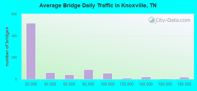
- 26,205,463Total average daily traffic
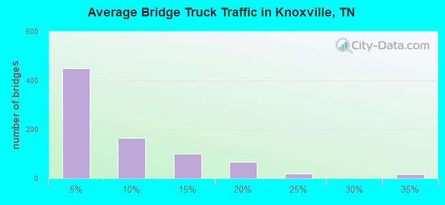
- 3,293,750Total average daily truck traffic
- National Bridge Inventory (NBI) Registered Bridges for Knoxville
- No street view available for this location
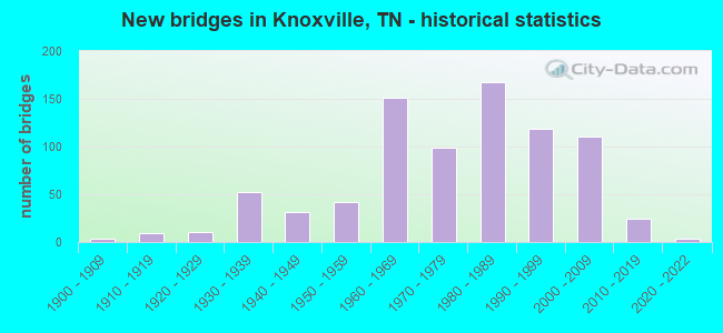
- New bridges - historical statistics
- 1Before 1900
- 31900-1909
- 91910-1919
- 111920-1929
- 521930-1939
- 311940-1949
- 421950-1959
- 1511960-1969
- 991970-1979
- 1681980-1989
- 1191990-1999
- 1112000-2009
- 242010-2019
- 32020-2022
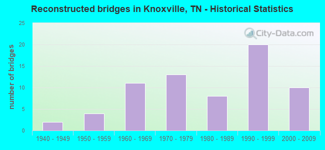
- Reconstructed bridges - Historical Statistics
- 21940-1949
- 41950-1959
- 111960-1969
- 131970-1979
- 81980-1989
- 201990-1999
- 102000-2009
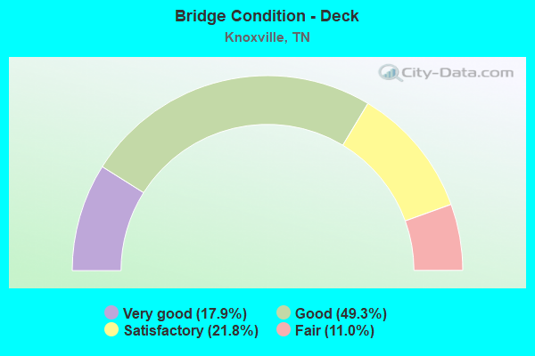
- Bridge Condition - Deck
- 17.9%Very good
- 49.3%Good
- 21.8%Satisfactory
- 11.0%Fair
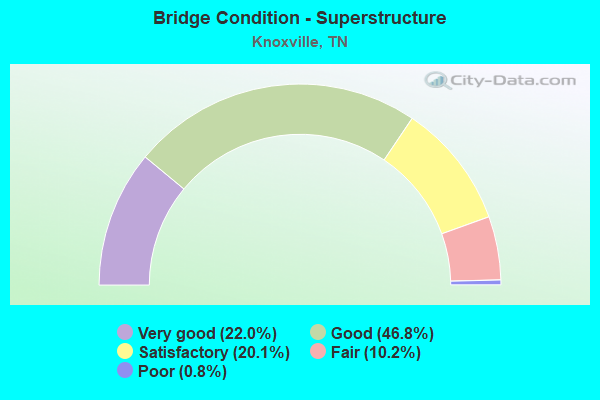
- Bridge Condition - Superstructure
- 22.0%Very good
- 46.8%Good
- 20.1%Satisfactory
- 10.2%Fair
- 0.8%Poor
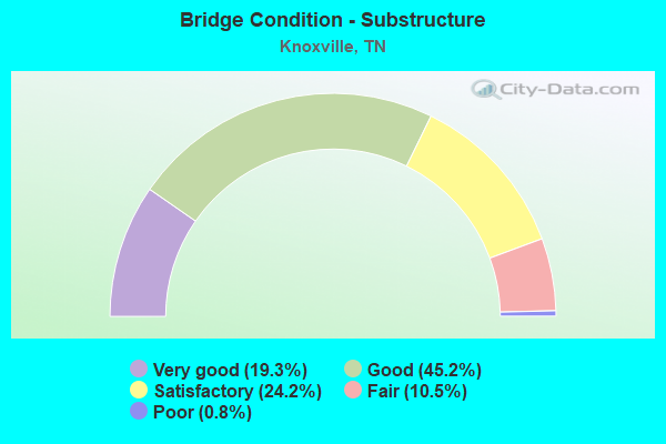
- Bridge Condition - Substructure
- 19.3%Very good
- 45.2%Good
- 24.2%Satisfactory
- 10.5%Fair
- 0.8%Poor
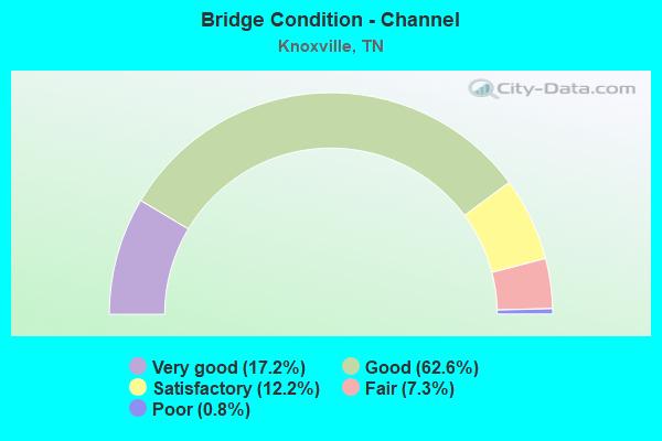
- Bridge Condition - Channel
- 17.2%Very good
- 62.6%Good
- 12.2%Satisfactory
- 7.3%Fair
- 0.8%Poor
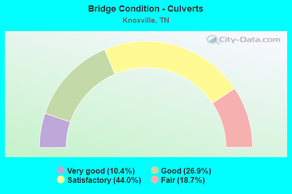
- Bridge Condition - Culverts
- 10.4%Very good
- 26.9%Good
- 44.0%Satisfactory
- 18.7%Fair
Find on map >> Show street view
Structure Number: 47SR1580037, Location: DOWNTOWN KNOXVILLE (Lat: 35.964800, Lng: -83.913867), Route carried "under" structure: Ramp State highway 71, Year Built: 2006, Structure Length: 0. m, Average Daily Traffic: 12,490 (year 2020), Truck Traffic: 13%, Features Intersected: CHURCH AVE / NB J WHITE, Facility Carried by Structure: NFA A033
Minimum Vertical Clearance: 5.61m (18.41ft), Kilometerpoint: 2.430, Lanes on structure: 4, Lanes under structure: 2, Material/Design: Steel continuous, Design/Construction: Stringer/Multi-beam, Length of Maximum Span: 30.4m (99.7ft)
Find on map >> Show street view
Structure Number: 47SR1580045, Location: DOWNTOWN KNOXVILLE (Lat: 35.969183, Lng: -83.916350), Route carried "under" structure: State highway 158, Year Built: 2006, Structure Length: 0. m, Average Daily Traffic: 33,144 (year 2020), Truck Traffic: 13%, Features Intersected: SUMMIT HILL DR / J.WHITE, Facility Carried by Structure: FAU 3788
Minimum Vertical Clearance: 5.03m (16.50ft), Kilometerpoint: 0.998, Lanes on structure: 6, Lanes under structure: 7, Material/Design: Prestressed concrete, Design/Construction: Box Beam or Girders - Multiple, Length of Maximum Span: 35.2m (115.5ft)
Find on map >> Show street view
Structure Number: 47SR1580049, Location: IN KNOXVILLE (Lat: 35.962583, Lng: -83.914333), Route carried "under" structure: City street 5657, Year Built: 1973, Structure Length: 0. m, Average Daily Traffic: 2,740 (year 2020), Truck Traffic: 4%, Features Intersected: W. MAIN AVE / S. CENTRAL, Facility Carried by Structure: FAU 3776 RAMP
Minimum Vertical Clearance: 7.63m (25.03ft), Kilometerpoint: 1.738, Lanes on structure: 1, Lanes under structure: 2, Material/Design: Concrete continuous, Design/Construction: Box Beam or Girders - Multiple, Length of Maximum Span: 29.6m (97.1ft)
Find on map >> Show street view
Structure Number: 47SR1580049, Location: IN KNOXVILLE (Lat: 35.962583, Lng: -83.914333), Route carried "under" structure: State highway 158, Year Built: 1973, Structure Length: 0. m, Average Daily Traffic: 13,490 (year 2020), Truck Traffic: 9%, Features Intersected: W. MAIN AVE / NEYLAND DR, Facility Carried by Structure: FAU 3776 RAMP
Minimum Vertical Clearance: 4.72m (15.49ft), Kilometerpoint: 0.306, Lanes on structure: 1, Lanes under structure: 4, Material/Design: Concrete continuous, Design/Construction: Box Beam or Girders - Multiple, Length of Maximum Span: 29.6m (97.1ft)
Find on map >> Show street view
Structure Number: 47SR1580053, Location: IN THE CITY OF KNOXVILLE (Lat: 35.959283, Lng: -83.917233), Route carried "under" structure: State highway 1, Year Built: 1997, Structure Length: 0. m, Average Daily Traffic: 12,902 (year 2020), Truck Traffic: 9%, Features Intersected: PED WALK / NEYLAND DR.
Minimum Vertical Clearance: 4.67m (15.32ft), Kilometerpoint: 31.978, Lanes under structure: 4, Material/Design: Steel continuous, Design/Construction: Stringer/Multi-beam, Length of Maximum Span: 24.1m (79.1ft)
Find on map >> Show street view
Structure Number: 47SR1580061, Location: DOWNTOWN KNOXVILLE (Lat: 35.981867, Lng: -83.917533), Route carried "under" structure: City street 158, Year Built: 2006, Structure Length: 0. m, Average Daily Traffic: 33,144 (year 2020), Truck Traffic: 13%, Features Intersected: SR158 EB RAMP 1B TUNNEL, Facility Carried by Structure: NFA 5666
Minimum Vertical Clearance: 5.11m (16.77ft), Kilometerpoint: 1.915, Lanes on structure: 5, Lanes under structure: 2, Material/Design: Concrete, Design/Construction: Arch - Deck, Length of Maximum Span: 12.8m (42.0ft)
Find on map >> Show street view
Structure Number: 47SR1580065, Location: DOWNTOWN KNOXVILLE (Lat: 35.974400, Lng: -83.917300), Route carried "under" structure: City street 507, Year Built: 2006, Structure Length: 0. m, Average Daily Traffic: 1,529 (year 2020), Truck Traffic: 5%, Features Intersected: J WHITE PK/OLD MAGNOLIA, Facility Carried by Structure: FAP 158
Minimum Vertical Clearance: 5.46m (17.91ft), Kilometerpoint: 0.798, Lanes on structure: 4, Lanes under structure: 5, Material/Design: Prestressed concrete continuous, Design/Construction: Box Beam or Girders - Single/Spread, Length of Maximum Span: 28.8m (94.5ft)
Find on map >> Show street view
Structure Number: 47SR1620005, Location: W OF KNOXVILLE (Lat: 35.949783, Lng: -84.157650), Route carried "under" structure: County highway 1277, Year Built: 1972, Structure Length: 0. m, Average Daily Traffic: 14,864 (year 2020), Truck Traffic: 4%, Features Intersected: SR162-RL /HARDIN VALLEY, Facility Carried by Structure: FAP 162
Minimum Vertical Clearance: 4.75m (15.58ft), Kilometerpoint: 11.201, Lanes on structure: 2, Lanes under structure: 4, Material/Design: Prestressed concrete, Design/Construction: Stringer/Multi-beam, Length of Maximum Span: 22.4m (73.5ft)
Find on map >> Show street view
Structure Number: 47SR1620006, Location: W OF KNOXVILLE (Lat: 35.949833, Lng: -84.157367), Route carried "under" structure: County highway 1277, Year Built: 1972, Structure Length: 0. m, Average Daily Traffic: 14,864 (year 2020), Truck Traffic: 4%, Features Intersected: SR162-LL /HARDIN VALLEY, Facility Carried by Structure: FAP 162
Minimum Vertical Clearance: 5.46m (17.91ft), Kilometerpoint: 11.169, Lanes on structure: 2, Lanes under structure: 4, Material/Design: Prestressed concrete, Design/Construction: Stringer/Multi-beam, Length of Maximum Span: 23.7m (77.8ft)
Find on map >> Show street view
Structure Number: 47SR1620007, Location: 2.2 MI N JCT I40&SR162 (Lat: 35.934717, Lng: -84.144933), Route carried "under" structure: County highway 131, Year Built: 1972, Structure Length: 0. m, Average Daily Traffic: 15,512 (year 2020), Truck Traffic: 4%, Features Intersected: SR162-NB / LOVELL RD, Facility Carried by Structure: FAP 162
Minimum Vertical Clearance: 4.65m (15.26ft), Kilometerpoint: 4.925, Lanes on structure: 2, Lanes under structure: 4, Material/Design: Steel, Design/Construction: Stringer/Multi-beam, Length of Maximum Span: 19.8m (65.0ft)
Find on map >> Show street view
Structure Number: 47SR1620008, Location: 2.2 MI N JCT I40&SR162 (Lat: 35.934933, Lng: -84.144850), Route carried "under" structure: County highway 131, Year Built: 1972, Structure Length: 0. m, Average Daily Traffic: 13,731 (year 2020), Truck Traffic: 4%, Features Intersected: SR162-SB / LOVELL RD, Facility Carried by Structure: FAP 162
Minimum Vertical Clearance: 4.55m (14.93ft), Kilometerpoint: 4.957, Lanes on structure: 2, Lanes under structure: 4, Material/Design: Steel, Design/Construction: Stringer/Multi-beam, Length of Maximum Span: 19.8m (65.0ft)
Find on map >> Show street view
Structure Number: 47SR1620009, Location: NEAR KNOXVILLE TENN. (Lat: 35.931667, Lng: -84.141667), Route carried "under" structure: State highway 162, Year Built: 1969, Structure Length: 0. m, Average Daily Traffic: 75,930 (year 2020), Truck Traffic: 9%, Features Intersected: BOB GRAY RD. / SR 162, Facility Carried by Structure: NFA C056
Minimum Vertical Clearance: 7.63m (25.03ft), Kilometerpoint: 6.614, Lanes on structure: 2, Lanes under structure: 4, Material/Design: Concrete continuous, Design/Construction: Tee Beam, Length of Maximum Span: 23.2m (76.1ft)
Find on map >> Show street view
Structure Number: 47SR1620039, Location: .3MI FROM JCT I40 & SR162 (Lat: 35.914417, Lng: -84.123167), Route carried "under" structure: Ramp State highway 162, Year Built: 2000, Structure Length: 0. m, Average Daily Traffic: 88,026 (year 2020), Truck Traffic: 13%, Features Intersected: SR162/162-RP TO I40 EAST
Minimum Vertical Clearance: 6.08m (19.95ft), Kilometerpoint: 9.093, Lanes on structure: 4, Lanes under structure: 2, Material/Design: Prestressed concrete continuous, Design/Construction: Stringer/Multi-beam, Length of Maximum Span: 30.2m (99.1ft)
Find on map >> Show street view
Structure Number: 47SR1620047, Location: NEAR KNOXVILLE (Lat: 35.925067, Lng: -84.133300), Route carried "under" structure: State highway 162, Year Built: 1999, Structure Length: 0. m, Average Daily Traffic: 75,930 (year 2020), Truck Traffic: 9%, Features Intersected: DUTCHTOWN RD / SR162, Facility Carried by Structure: FAU 4832
Minimum Vertical Clearance: 5.01m (16.44ft), Kilometerpoint: 7.596, Lanes on structure: 5, Lanes under structure: 6, Material/Design: Prestressed concrete continuous, Design/Construction: Stringer/Multi-beam, Length of Maximum Span: 41.5m (136.2ft)
Find on map >> Show street view
Structure Number: 47SR1680001, Location: NEAR SR 71 (Lat: 35.900833, Lng: -83.856500), Route carried "under" structure: State highway 168, Year Built: 1973, Structure Length: 0. m, Average Daily Traffic: 20,749 (year 2020), Truck Traffic: 4%, Features Intersected: DICK FORD ROAD / SR 168, Facility Carried by Structure: NFA D942
Minimum Vertical Clearance: 4.72m (15.49ft), Kilometerpoint: 9.061, Lanes on structure: 2, Lanes under structure: 2, Material/Design: Prestressed concrete, Design/Construction: Box Beam or Girders - Multiple, Length of Maximum Span: 42.8m (140.4ft)
Find on map >> Show street view
Structure Number: 47SR1690003, Location: JUST E OF I75 (Lat: 35.962467, Lng: -83.972833), Route carried "under" structure: State highway 169, Year Built: 1978, Structure Length: 0. m, Average Daily Traffic: 15,323 (year 2020), Truck Traffic: 4%, Features Intersected: CSX RR / SR169, Facility Carried by Structure: CSX RR 347569E
Minimum Vertical Clearance: 6.07m (19.91ft), Kilometerpoint: 15.080, Lanes under structure: 4, Material/Design: Steel, Design/Construction: Stringer/Multi-beam, Length of Maximum Span: 19.2m (63.0ft)
Find on map >> Show street view
Structure Number: 47SR1690007, Location: SO. OF SR062 (Lat: 35.963500, Lng: -83.945233), Route carried "under" structure: State highway 169, Year Built: 2000, Structure Length: 0. m, Average Daily Traffic: 15,414 (year 2020), Truck Traffic: 4%, Features Intersected: 21ST. STREET / SR169, Facility Carried by Structure: NFA A499
Minimum Vertical Clearance: 6.00m (19.69ft), Kilometerpoint: 18.009, Lanes on structure: 1, Lanes under structure: 4, Material/Design: Steel continuous, Design/Construction: Stringer/Multi-beam, Length of Maximum Span: 46.0m (150.9ft)
Find on map >> Show street view
Structure Number: 47X00710001, Location: SE KNOXVILLE (Lat: 35.960800, Lng: -83.897750), Route carried "under" structure: City street 5660, Year Built: 1983, Structure Length: 0. m, Average Daily Traffic: 1,651 (year 2020), Truck Traffic: 3%, Features Intersected: J WHITE PKWY/ISLAND HOME, Facility Carried by Structure: FAP 71
Minimum Vertical Clearance: 7.63m (25.03ft), Kilometerpoint: 0.966, Lanes on structure: 6, Lanes under structure: 2, Material/Design: Steel continuous, Design/Construction: Stringer/Multi-beam, Length of Maximum Span: 118.9m (390.1ft)
Find on map >> Show street view
Structure Number: 47X00710001, Location: SE KNOXVILLE (Lat: 35.964433, Lng: -83.897333), Route carried "under" structure: City street 1124, Year Built: 1983, Structure Length: 0. m, Average Daily Traffic: 4,047 (year 2020), Truck Traffic: 3%, Features Intersected: J WHITE PKWY / RIVERSIDE, Facility Carried by Structure: FAP 71
Minimum Vertical Clearance: 7.63m (25.03ft), Kilometerpoint: 0.322, Lanes on structure: 6, Lanes under structure: 2, Material/Design: Steel continuous, Design/Construction: Stringer/Multi-beam, Length of Maximum Span: 118.9m (390.1ft)