Bridge Statistics for Knoxville, Tennessee (TN)
Condition, Traffic, Stress, Structural Evaluation, Project Costs
- National Bridge Inventory (NBI) Statistics
- 824Number of bridges
- 10,413ft / 3,174mTotal length
- $454,697,000Total costs
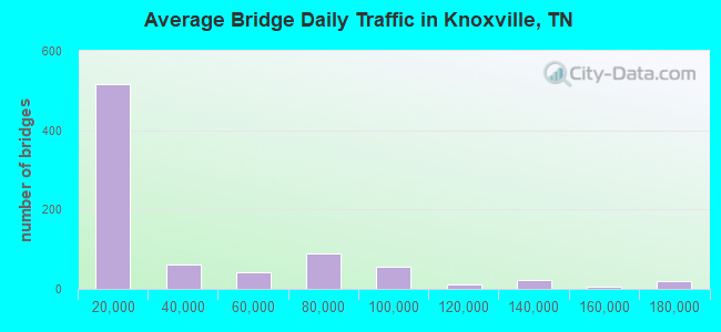
- 26,205,463Total average daily traffic
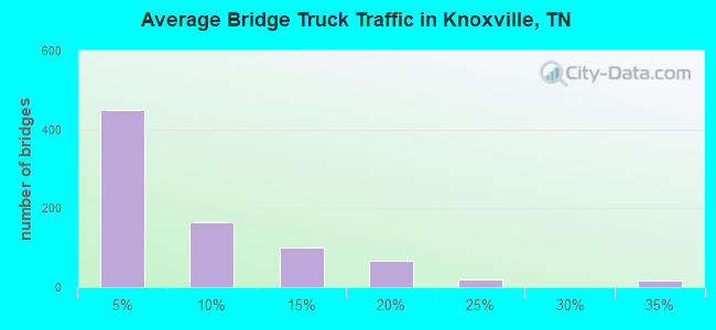
- 3,293,750Total average daily truck traffic
- National Bridge Inventory (NBI) Registered Bridges for Knoxville
- No street view available for this location
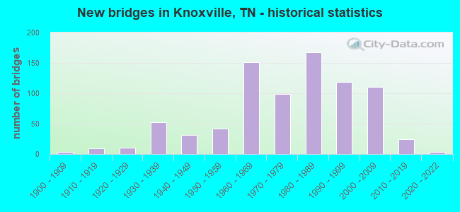
- New bridges - historical statistics
- 1Before 1900
- 31900-1909
- 91910-1919
- 111920-1929
- 521930-1939
- 311940-1949
- 421950-1959
- 1511960-1969
- 991970-1979
- 1681980-1989
- 1191990-1999
- 1112000-2009
- 242010-2019
- 32020-2022
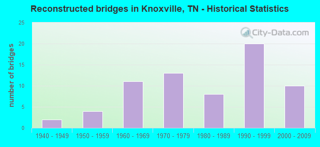
- Reconstructed bridges - Historical Statistics
- 21940-1949
- 41950-1959
- 111960-1969
- 131970-1979
- 81980-1989
- 201990-1999
- 102000-2009
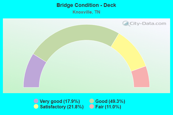
- Bridge Condition - Deck
- 17.9%Very good
- 49.3%Good
- 21.8%Satisfactory
- 11.0%Fair
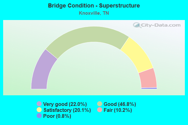
- Bridge Condition - Superstructure
- 22.0%Very good
- 46.8%Good
- 20.1%Satisfactory
- 10.2%Fair
- 0.8%Poor
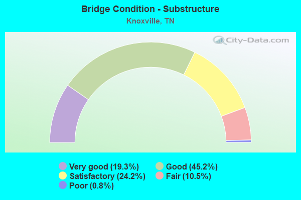
- Bridge Condition - Substructure
- 19.3%Very good
- 45.2%Good
- 24.2%Satisfactory
- 10.5%Fair
- 0.8%Poor
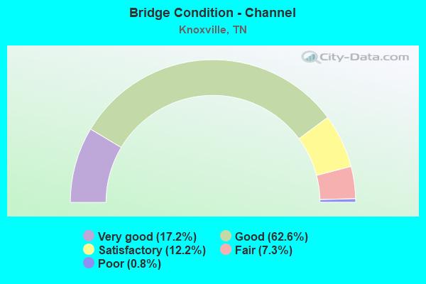
- Bridge Condition - Channel
- 17.2%Very good
- 62.6%Good
- 12.2%Satisfactory
- 7.3%Fair
- 0.8%Poor
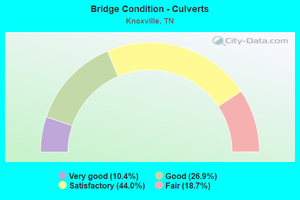
- Bridge Condition - Culverts
- 10.4%Very good
- 26.9%Good
- 44.0%Satisfactory
- 18.7%Fair
Find on map >> Show street view
Structure Number: 47I00400153, Location: CITY OF KNOXVILLE (Lat: 35.965800, Lng: -83.925933), Route carried "under" structure: City street 571, Year Built: 1986, Structure Length: 0. m, Average Daily Traffic: 50 (year 2022), Truck Traffic: 2%, Features Intersected: I40-EB RMP/ WORLDS FAIR, Facility Carried by Structure: I40 RAMP 5-C
Minimum Vertical Clearance: 6.51m (21.36ft), Kilometerpoint: 0.225, Lanes on structure: 1, Lanes under structure: 2, Material/Design: Steel continuous, Design/Construction: Stringer/Multi-beam, Length of Maximum Span: 54.7m (179.5ft)
Find on map >> Show street view
Structure Number: 47I00400157, Location: CITY OF KNOXVILLE (Lat: 35.968467, Lng: -83.929000), Route carried "under" structure: Interstate 40, Year Built: 1986, Structure Length: 0. m, Average Daily Traffic: 104,800 (year 2020), Truck Traffic: 15%, Features Intersected: SR1 RP G / I40, Facility Carried by Structure: FAP 1 RAMP 5G
Minimum Vertical Clearance: 5.14m (16.86ft), Kilometerpoint: 30.312, Lanes on structure: 2, Lanes under structure: 7, Material/Design: Steel continuous, Design/Construction: Stringer/Multi-beam, Length of Maximum Span: 47.8m (156.8ft)
Find on map >> Show street view
Structure Number: 47I00400157, Location: CITY OF KNOXVILLE (Lat: 35.968283, Lng: -83.928800), Route carried "under" structure: Ramp State highway 62, Year Built: 1986, Structure Length: 0. m, Average Daily Traffic: 13,893 (year 2020), Truck Traffic: 9%, Features Intersected: SR 1 RP-G / SR-62, Facility Carried by Structure: FAP 1 RAMP 5G
Minimum Vertical Clearance: 5.42m (17.78ft), Kilometerpoint: 25.846, Lanes on structure: 2, Lanes under structure: 1, Material/Design: Steel continuous, Design/Construction: Stringer/Multi-beam, Length of Maximum Span: 47.8m (156.8ft)
Find on map >> Show street view
Structure Number: 47I00400157, Location: CITY OF KNOXVILLE (Lat: 35.967350, Lng: -83.927750), Route carried "under" structure: City street 5927, Year Built: 1986, Structure Length: 0. m, Average Daily Traffic: 1,426 (year 2020), Truck Traffic: 3%, Features Intersected: SR1-RP-G / BLACKSTOCK, Facility Carried by Structure: FAP 1 RAMP 5G
Minimum Vertical Clearance: 7.63m (25.03ft), Kilometerpoint: 0.628, Lanes on structure: 2, Lanes under structure: 4, Material/Design: Steel continuous, Design/Construction: Stringer/Multi-beam, Length of Maximum Span: 47.8m (156.8ft)
Find on map >> Show street view
Structure Number: 47I00400161, Location: CITY OF KNOXVILLE (Lat: 35.966467, Lng: -83.928167), Route carried "under" structure: City street 220, Year Built: 1994, Structure Length: 0. m, Average Daily Traffic: 1,426 (year 2020), Truck Traffic: 3%, Features Intersected: I40-EB-RP H / BLACKSTOC, Facility Carried by Structure: I40 RAMP 5-H
Minimum Vertical Clearance: 6.00m (19.69ft), Kilometerpoint: 0.536, Lanes on structure: 1, Lanes under structure: 3, Material/Design: Steel continuous, Design/Construction: Stringer/Multi-beam, Length of Maximum Span: 41.1m (134.8ft)
Find on map >> Show street view
Structure Number: 47I00400163, Location: CITY OF KNOXVILLE (Lat: 35.911283, Lng: -84.121950), Route carried "under" structure: Interstate 40, Year Built: 1996, Structure Length: 0. m, Average Daily Traffic: 100,704 (year 2020), Truck Traffic: 17%, Features Intersected: I-140 / I40
Minimum Vertical Clearance: 5.16m (16.93ft), Kilometerpoint: 11.426, Lanes on structure: 6, Lanes under structure: 6, Material/Design: Steel continuous, Design/Construction: Stringer/Multi-beam, Length of Maximum Span: 58.5m (191.9ft)
Find on map >> Show street view
Structure Number: 47I00400165, Location: AT PELLISSIPPI PKWY. (Lat: 35.912283, Lng: -84.117317), Route carried "under" structure: Interstate 40, Year Built: 1998, Structure Length: 0. m, Average Daily Traffic: 143,994 (year 2020), Truck Traffic: 17%, Features Intersected: SR 162 SB RMP TO I40/I40, Facility Carried by Structure: FAP 162
Minimum Vertical Clearance: 5.26m (17.26ft), Kilometerpoint: 11.893, Lanes on structure: 2, Lanes under structure: 10, Material/Design: Steel continuous, Design/Construction: Stringer/Multi-beam, Length of Maximum Span: 77.7m (254.9ft)
Find on map >> Show street view
Structure Number: 47I00400167, Location: DOWNTOWN KNOXVILLE (Lat: 35.963067, Lng: -83.948083), Route carried "under" structure: Ramp Interstate 40, Year Built: 2001, Structure Length: 0. m, Average Daily Traffic: 121,876 (year 2020), Truck Traffic: 13%, Features Intersected: I40-EB RMP / I40 WB RAMP
Minimum Vertical Clearance: 5.14m (16.86ft), Kilometerpoint: 28.341, Lanes on structure: 2, Lanes under structure: 1, Material/Design: Steel continuous, Design/Construction: Stringer/Multi-beam, Length of Maximum Span: 35.7m (117.1ft)
Find on map >> Show street view
Structure Number: 47I00400167, Location: DOWNTOWN KNOXVILLE (Lat: 35.962367, Lng: -83.947217), Route carried "under" structure: City street 169, Year Built: 2001, Structure Length: 0. m, Average Daily Traffic: 15,414 (year 2020), Truck Traffic: 4%, Features Intersected: I40-EB RMP / UNIVERSITY, Facility Carried by Structure: I40 RAMP
Minimum Vertical Clearance: 7.63m (25.03ft), Kilometerpoint: 17.799, Lanes on structure: 2, Lanes under structure: 6, Material/Design: Steel continuous, Design/Construction: Stringer/Multi-beam, Length of Maximum Span: 35.7m (117.1ft)
Find on map >> Show street view
Structure Number: 47I00400173, Location: DOWNTOWN KNOXVILLE (Lat: 35.967883, Lng: -83.929333), Route carried "under" structure: Interstate 40, Year Built: 1982, Structure Length: 0. m, Average Daily Traffic: 122,095 (year 2020), Truck Traffic: 12%, Features Intersected: SR62 RAMP / I40 EB RAMP, Facility Carried by Structure: FAU 62
Minimum Vertical Clearance: 5.06m (16.60ft), Kilometerpoint: 29.934, Lanes on structure: 1, Lanes under structure: 1, Material/Design: Steel continuous, Design/Construction: Stringer/Multi-beam, Length of Maximum Span: 31.7m (104.0ft)
Find on map >> Show street view
Structure Number: 47I00400175, Location: DOWNTOWN KNOXVILLE (Lat: 35.962800, Lng: -84.950467), Route carried "under" structure: State highway 169, Year Built: 2001, Structure Length: 0. m, Average Daily Traffic: 15,323 (year 2020), Truck Traffic: 4%, Features Intersected: I40EB RMP/M'BROOK-RR, Facility Carried by Structure: I40
Minimum Vertical Clearance: 7.63m (25.03ft), Kilometerpoint: 17.284, Lanes on structure: 1, Lanes under structure: 4, Material/Design: Steel, Design/Construction: Stringer/Multi-beam, Length of Maximum Span: 44.2m (145.0ft)
Find on map >> Show street view
Structure Number: 47I00400177, Location: IN KNOXVILLE (Lat: 35.962467, Lng: -83.930117), Route carried "under" structure: City street 169, Year Built: 1966, Structure Length: 0. m, Average Daily Traffic: 15,414 (year 2020), Truck Traffic: 4%, Features Intersected: I40-WB-RMP/UNIVERSITY AV, Facility Carried by Structure: I40 RMP
Minimum Vertical Clearance: 5.29m (17.36ft), Kilometerpoint: 17.622, Lanes on structure: 1, Lanes under structure: 4, Material/Design: Steel, Design/Construction: Stringer/Multi-beam, Length of Maximum Span: 16.2m (53.1ft)
Find on map >> Show street view
Structure Number: 47I00400179, Location: .3 MI N OF SR1 (Lat: 35.938400, Lng: -84.009233), Route carried "under" structure: City street 5289, Year Built: 2004, Structure Length: 0. m, Average Daily Traffic: 20,256 (year 2020), Truck Traffic: 4%, Features Intersected: I40-WB / WEISGARBER ROAD, Facility Carried by Structure: I40
Minimum Vertical Clearance: 4.48m (14.70ft), Kilometerpoint: 0.885, Lanes on structure: 3, Lanes under structure: 3, Material/Design: Steel continuous, Design/Construction: Stringer/Multi-beam, Length of Maximum Span: 36.1m (118.4ft)
Find on map >> Show street view
Structure Number: 47I00400181, Location: .4 MI N OF SR1 (Lat: 35.939617, Lng: -84.008683), Route carried "under" structure: Ramp Interstate 40, Year Built: 2004, Structure Length: 0. m, Average Daily Traffic: 171,281 (year 2020), Truck Traffic: 11%, Features Intersected: 5289&I40 RP / I40-RP 5A, Facility Carried by Structure: FAU 5289
Minimum Vertical Clearance: 5.06m (16.60ft), Kilometerpoint: 22.209, Lanes on structure: 1, Lanes under structure: 3, Material/Design: Steel continuous, Design/Construction: Stringer/Multi-beam, Length of Maximum Span: 32.3m (106.0ft)
Find on map >> Show street view
Structure Number: 47I00400183, Location: JUST EAST OF WEST TOWN (Lat: 35.984833, Lng: -83.914600), Route carried "under" structure: City street 480, Year Built: 2005, Structure Length: 0. m, Average Daily Traffic: 21,050 (year 2018), Truck Traffic: 2%, Features Intersected: I40 / N. 6TH STREET, Facility Carried by Structure: I40
Minimum Vertical Clearance: 7.62m (25.00ft), Kilometerpoint: 0.842, Lanes on structure: 2, Lanes under structure: 2, Material/Design: Prestressed concrete continuous, Design/Construction: Stringer/Multi-beam, Length of Maximum Span: 17.3m (56.8ft)
Find on map >> Show street view
Structure Number: 47I00400187, Location: JUST NORTH OF SR001 (Lat: 35.928417, Lng: -84.042883), Route carried "under" structure: City street A111, Year Built: 2005, Structure Length: 0. m, Average Daily Traffic: 13,628 (year 2020), Truck Traffic: 4%, Features Intersected: I40 / MONTVUE RD., Facility Carried by Structure: I0040
Minimum Vertical Clearance: 5.24m (17.19ft), Kilometerpoint: 0.835, Lanes on structure: 8, Lanes under structure: 6, Material/Design: Prestressed concrete continuous, Design/Construction: Stringer/Multi-beam, Length of Maximum Span: 38.4m (126.0ft)
Find on map >> Show street view
Structure Number: 47I00400189, Location: WEST SIDE OF KNOXVILLE (Lat: 35.929583, Lng: -84.036850), Route carried "under" structure: City street 3777, Year Built: 1968, Structure Length: 0. m, Average Daily Traffic: 13,392 (year 2020), Truck Traffic: 4%, Features Intersected: I40-EB-RMP / BUCKINGHAM, Facility Carried by Structure: I40
Minimum Vertical Clearance: 5.64m (18.50ft), Kilometerpoint: 0.177, Lanes on structure: 1, Lanes under structure: 3, Material/Design: Prestressed concrete continuous, Design/Construction: Stringer/Multi-beam, Length of Maximum Span: 15.0m (49.2ft)
Find on map >> Show street view
Structure Number: 47I00400191, Location: NORTH OF I40 (Lat: 35.942533, Lng: -84.001450), Route carried "under" structure: City street 4174, Year Built: 2005, Structure Length: 0. m, Average Daily Traffic: 1,895 (year 2020), Truck Traffic: 3%, Features Intersected: I40-WB-RMP / PAPERMILL, Facility Carried by Structure: WB I40 FRONTAGE RD
Minimum Vertical Clearance: 5.09m (16.70ft), Kilometerpoint: 0.032, Lanes on structure: 1, Lanes under structure: 7, Material/Design: Steel, Design/Construction: Stringer/Multi-beam, Length of Maximum Span: 37.9m (124.3ft)
Find on map >> Show street view
Structure Number: 47I00400193, Location: AT I-40 & SR332 (Lat: 35.940750, Lng: -84.003650), Route carried "under" structure: Ramp Interstate 40, Year Built: 2005, Structure Length: 0. m, Average Daily Traffic: 170,026 (year 2020), Truck Traffic: 11%, Features Intersected: I40-RP-6-B2 /I40-RP-6-C1
Minimum Vertical Clearance: 5.01m (16.44ft), Kilometerpoint: 22.821, Lanes on structure: 1, Lanes under structure: 1, Material/Design: Steel, Design/Construction: Stringer/Multi-beam, Length of Maximum Span: 35.6m (116.8ft)
Find on map >> Show street view
Structure Number: 47I00400197, Location: DOWNTOWN KNOXVILLE (Lat: 35.940000, Lng: -84.001667), Route carried "under" structure: City street 507, Year Built: 2007, Structure Length: 0. m, Average Daily Traffic: 1,529 (year 2020), Truck Traffic: 5%, Features Intersected: I40-EB-RMP/OLD MAGNOLIA, Facility Carried by Structure: I40(RAMP)
Minimum Vertical Clearance: 5.49m (18.01ft), Kilometerpoint: 0.732, Lanes on structure: 2, Lanes under structure: 4, Material/Design: Steel continuous, Design/Construction: Stringer/Multi-beam, Length of Maximum Span: 35.1m (115.2ft)
Find on map >> Show street view
Structure Number: 47I00400199, Location: DOWNTOWN KNOXVILLE (Lat: 35.975450, Lng: -83.918333), Route carried "under" structure: Ramp Interstate 40, Year Built: 2007, Structure Length: 0. m, Average Daily Traffic: 80,617 (year 2020), Truck Traffic: 22%, Features Intersected: SR158 / I40 WB RMP 1A, Facility Carried by Structure: FAP 158
Minimum Vertical Clearance: 5.00m (16.40ft), Kilometerpoint: 31.447, Lanes on structure: 2, Lanes under structure: 2, Material/Design: Prestressed concrete, Design/Construction: Stringer/Multi-beam, Length of Maximum Span: 17.7m (58.1ft)
Find on map >> Show street view
Structure Number: 47I00400201, Location: IN KNOXVILLE @ I40 EXCH (Lat: 35.976083, Lng: -83.918667), Route carried "under" structure: Interstate 40, Year Built: 1962, Structure Length: 0. m, Average Daily Traffic: 80,617 (year 2020), Truck Traffic: 22%, Features Intersected: I40-WB RP TO SR158-LL, Facility Carried by Structure: SR-1
Minimum Vertical Clearance: 5.44m (17.85ft), Kilometerpoint: 31.463, Lanes on structure: 4, Lanes under structure: 2, Material/Design: Steel continuous, Design/Construction: Stringer/Multi-beam, Length of Maximum Span: 15.1m (49.5ft)
Find on map >> Show street view
Structure Number: 47I00400204, Location: NEAR KNOXVILLE TENN. (Lat: 35.974100, Lng: -83.917733), Route carried "under" structure: City street 507, Year Built: 1965, Structure Length: 0. m, Average Daily Traffic: 1,529 (year 2020), Truck Traffic: 5%, Features Intersected: I40-WB-RMP/OLD MAGNOLIA, Facility Carried by Structure: I40
Minimum Vertical Clearance: 4.78m (15.68ft), Kilometerpoint: 0.766, Lanes on structure: 2, Lanes under structure: 5, Material/Design: Steel, Design/Construction: Stringer/Multi-beam, Length of Maximum Span: 16.2m (53.1ft)
Find on map >> Show street view
Structure Number: 47I00400205, Location: WILLOW AVENUE (Lat: 35.970017, Lng: -83.916550), Route carried "under" structure: County highway 141, Year Built: 2006, Structure Length: 0. m, Average Daily Traffic: 8,100 (year 2022), Truck Traffic: 2%, Features Intersected: I40 RMPS / WILLOW AVE., Facility Carried by Structure: I40
Minimum Vertical Clearance: 4.40m (14.44ft), Kilometerpoint: 0.163, Lanes on structure: 3, Lanes under structure: 2, Material/Design: Prestressed concrete continuous, Design/Construction: Stringer/Multi-beam, Length of Maximum Span: 40.9m (134.2ft)
Find on map >> Show street view
Structure Number: 47I00400205, Location: WILLOW AVENUE (Lat: 35.970183, Lng: -83.916367), Route carried "under" structure: County highway 141, Year Built: 2006, Structure Length: 0. m, Average Daily Traffic: 8,100 (year 2022), Truck Traffic: 2%, Features Intersected: I40 RMPS / WILLOW AVE., Facility Carried by Structure: I40
Minimum Vertical Clearance: 5.92m (19.42ft), Kilometerpoint: 0.200, Lanes on structure: 4, Lanes under structure: 2, Material/Design: Prestressed concrete continuous, Design/Construction: Stringer/Multi-beam, Length of Maximum Span: 40.9m (134.2ft)
Find on map >> Show street view
Structure Number: 47I00400205, Location: JACKSON AVENUE (Lat: 35.971950, Lng: -83.916317), Route carried "under" structure: County highway 887, Year Built: 2006, Structure Length: 0. m, Average Daily Traffic: 8,100 (year 2022), Truck Traffic: 2%, Features Intersected: I40 RMPS / JACKSON AVE., Facility Carried by Structure: I40
Minimum Vertical Clearance: 7.63m (25.03ft), Kilometerpoint: 0.583, Lanes on structure: 4, Lanes under structure: 2, Material/Design: Prestressed concrete continuous, Design/Construction: Stringer/Multi-beam, Length of Maximum Span: 40.9m (134.2ft)
Find on map >> Show street view
Structure Number: 47I00400205, Location: WILLOW AVENUE (Lat: 35.969833, Lng: -83.916933), Route carried "under" structure: County highway 141, Year Built: 2006, Structure Length: 0. m, Average Daily Traffic: 8,100 (year 2022), Truck Traffic: 2%, Features Intersected: I40 RMPS / WILLOW AVE., Facility Carried by Structure: I40
Minimum Vertical Clearance: 4.53m (14.86ft), Kilometerpoint: 0.121, Lanes on structure: 2, Lanes under structure: 2, Material/Design: Prestressed concrete continuous, Design/Construction: Stringer/Multi-beam, Length of Maximum Span: 40.9m (134.2ft)
Find on map >> Show street view
Structure Number: 47I00400207, Location: EAST OF I-40 VIADUCT (Lat: 35.981667, Lng: -83.918333), Route carried "under" structure: Ramp Interstate 40, Year Built: 2007, Structure Length: 0. m, Average Daily Traffic: 80,617 (year 2020), Truck Traffic: 22%, Features Intersected: HOF DR RMP 2D/I40 RMP 1A, Facility Carried by Structure: SR 33
Minimum Vertical Clearance: 5.16m (16.93ft), Kilometerpoint: 31.881, Lanes on structure: 2, Lanes under structure: 2, Material/Design: Prestressed concrete continuous, Design/Construction: Stringer/Multi-beam, Length of Maximum Span: 38.8m (127.3ft)
Find on map >> Show street view
Structure Number: 47I00400303, Location: AT I40-I75 EXCHANGE (Lat: 35.957567, Lng: -83.971850), Route carried "under" structure: City street 4174, Year Built: 1982, Structure Length: 0. m, Average Daily Traffic: 1,895 (year 2020), Truck Traffic: 3%, Features Intersected: I40-WB RMP-I75N / P'MILL, Facility Carried by Structure: I40 RMP C-C
Minimum Vertical Clearance: 5.34m (17.52ft), Kilometerpoint: 3.251, Lanes on structure: 1, Lanes under structure: 2, Material/Design: Steel, Design/Construction: Stringer/Multi-beam, Length of Maximum Span: 37.8m (124.0ft)
Find on map >> Show street view
Structure Number: 47I00750001, Location: AT I40-I75 EXCHANGE (Lat: 35.957467, Lng: -83.972667), Route carried "under" structure: City street 4174, Year Built: 1965, Structure Length: 0. m, Average Daily Traffic: 1,895 (year 2020), Truck Traffic: 3%, Features Intersected: I75 SB RMP/PAPERMILL RD., Facility Carried by Structure: I75 LL
Minimum Vertical Clearance: 7.63m (25.03ft), Kilometerpoint: 3.154, Lanes on structure: 2, Lanes under structure: 2, Material/Design: Steel continuous, Design/Construction: Stringer/Multi-beam, Length of Maximum Span: 28.7m (94.2ft)
Find on map >> Show street view
Structure Number: 47I00750005, Location: AT I40-I75 EXCHANGE (Lat: 35.958050, Lng: -83.971783), Route carried "under" structure: City street 4174, Year Built: 1981, Structure Length: 0. m, Average Daily Traffic: 1,895 (year 2020), Truck Traffic: 3%, Features Intersected: I40 EB RP TO I75 /P'MILL, Facility Carried by Structure: I75 RL
Minimum Vertical Clearance: 5.11m (16.77ft), Kilometerpoint: 3.251, Lanes on structure: 2, Lanes under structure: 3, Material/Design: Steel continuous, Design/Construction: Stringer/Multi-beam, Length of Maximum Span: 48.8m (160.1ft)
Find on map >> Show street view
Structure Number: 47I00750007, Location: IN KNOXVILLE (Lat: 35.962117, Lng: -83.974450), Route carried "under" structure: Interstate 75, Year Built: 1981, Structure Length: 0. m, Average Daily Traffic: 86,616 (year 2020), Truck Traffic: 17%, Features Intersected: MIDDLEBROOK PK / I75, Facility Carried by Structure: FAU 169
Minimum Vertical Clearance: 5.09m (16.70ft), Kilometerpoint: 0.676, Lanes on structure: 4, Lanes under structure: 6, Material/Design: Concrete continuous, Design/Construction: Box Beam or Girders - Multiple, Length of Maximum Span: 44.2m (145.0ft)
Find on map >> Show street view
Structure Number: 47I00750013, Location: IN KNOXVILLE (Lat: 35.974117, Lng: -83.979250), Route carried "under" structure: Interstate 75, Year Built: 1981, Structure Length: 0. m, Average Daily Traffic: 86,616 (year 2020), Truck Traffic: 17%, Features Intersected: SR 62 / I75, Facility Carried by Structure: FAP 62
Minimum Vertical Clearance: 5.39m (17.68ft), Kilometerpoint: 2.157, Lanes on structure: 8, Lanes under structure: 6, Material/Design: Concrete continuous, Design/Construction: Box Beam or Girders - Multiple, Length of Maximum Span: 50.7m (166.3ft)
Find on map >> Show street view
Structure Number: 47I00750013, Location: IN KNOXVILLE (Lat: 35.974133, Lng: -83.978767), Route carried "under" structure: Ramp Interstate 75, Year Built: 1981, Structure Length: 0. m, Average Daily Traffic: 92,735 (year 2020), Truck Traffic: 17%, Features Intersected: SR 62 / I75 NB RMP, Facility Carried by Structure: FAP 62
Minimum Vertical Clearance: 5.19m (17.03ft), Kilometerpoint: 2.189, Lanes on structure: 7, Lanes under structure: 2, Material/Design: Concrete continuous, Design/Construction: Box Beam or Girders - Multiple, Length of Maximum Span: 50.7m (166.3ft)
Find on map >> Show street view
Structure Number: 47I00750015, Location: N. OF SR 62 (Lat: 35.978733, Lng: -83.978967), Route carried "under" structure: Interstate 75, Year Built: 1981, Structure Length: 0. m, Average Daily Traffic: 92,735 (year 2020), Truck Traffic: 17%, Features Intersected: MYRTLEWOOD RD. / I75, Facility Carried by Structure: NFA A823
Minimum Vertical Clearance: 4.91m (16.11ft), Kilometerpoint: 2.672, Lanes on structure: 2, Lanes under structure: 8, Material/Design: Concrete continuous, Design/Construction: Box Beam or Girders - Multiple, Length of Maximum Span: 51.7m (169.6ft)
Find on map >> Show street view
Structure Number: 47I00750019, Location: N. OF SR 62 (Lat: 35.983983, Lng: -83.977200), Route carried "under" structure: Interstate 75, Year Built: 1981, Structure Length: 0. m, Average Daily Traffic: 92,735 (year 2020), Truck Traffic: 17%, Features Intersected: PLEASANT RIDGE RD. / I75, Facility Carried by Structure: FAU 1254
Minimum Vertical Clearance: 5.11m (16.77ft), Kilometerpoint: 3.315, Lanes on structure: 2, Lanes under structure: 6, Material/Design: Concrete continuous, Design/Construction: Box Beam or Girders - Multiple, Length of Maximum Span: 38.4m (126.0ft)
Find on map >> Show street view
Structure Number: 47I00750021, Location: N. OF SR 62 (Lat: 35.987600, Lng: -83.973017), Route carried "under" structure: Interstate 75, Year Built: 1981, Structure Length: 0. m, Average Daily Traffic: 92,735 (year 2020), Truck Traffic: 17%, Features Intersected: WILSON RD. / I75, Facility Carried by Structure: NFA A080
Minimum Vertical Clearance: 4.88m (16.01ft), Kilometerpoint: 3.846, Lanes on structure: 2, Lanes under structure: 6, Material/Design: Concrete continuous, Design/Construction: Tee Beam, Length of Maximum Span: 48.8m (160.1ft)
Find on map >> Show street view
Structure Number: 47I00750023, Location: S. OF SHARPS GAP (Lat: 35.993950, Lng: -83.966233), Route carried "under" structure: Interstate 75, Year Built: 1981, Structure Length: 0. m, Average Daily Traffic: 92,735 (year 2020), Truck Traffic: 17%, Features Intersected: GAP RD. / I75, Facility Carried by Structure: NFA A842
Minimum Vertical Clearance: 5.57m (18.27ft), Kilometerpoint: 4.796, Lanes on structure: 3, Lanes under structure: 8, Material/Design: Concrete continuous, Design/Construction: Box Beam or Girders - Multiple, Length of Maximum Span: 33.5m (109.9ft)
Find on map >> Show street view
Structure Number: 47I00750025, Location: NEAR KNOXVILLE TENN. (Lat: 35.998600, Lng: -83.960333), Route carried "under" structure: US 25, Year Built: 1959, Structure Length: 0. m, Average Daily Traffic: 21,926 (year 2020), Truck Traffic: 9%, Features Intersected: I75 /SR-9 (CLINTON HWY), Facility Carried by Structure: I75
Minimum Vertical Clearance: 4.80m (15.75ft), Kilometerpoint: 11.233, Lanes on structure: 7, Lanes under structure: 5, Material/Design: Steel continuous, Design/Construction: Stringer/Multi-beam, Length of Maximum Span: 28.7m (94.2ft)
Find on map >> Show street view
Structure Number: 47I00750029, Location: NEAR KNOXVILLE TENN. (Lat: 36.003550, Lng: -83.962450), Route carried "under" structure: Interstate 75, Year Built: 1965, Structure Length: 0. m, Average Daily Traffic: 79,723 (year 2020), Truck Traffic: 17%, Features Intersected: TILLERY RD. / I75, Facility Carried by Structure: NFA B150
Minimum Vertical Clearance: 4.98m (16.34ft), Kilometerpoint: 6.309, Lanes on structure: 2, Lanes under structure: 4, Material/Design: Concrete continuous, Design/Construction: Tee Beam, Length of Maximum Span: 43.6m (143.0ft)
Find on map >> Show street view
Structure Number: 47I00750031, Location: NEAR KNOXVILLE TENN. (Lat: 36.007133, Lng: -83.967683), Route carried "under" structure: Interstate 75, Year Built: 1965, Structure Length: 0. m, Average Daily Traffic: 79,723 (year 2020), Truck Traffic: 17%, Features Intersected: INSKIP RD. / I75, Facility Carried by Structure: NFA B135
Minimum Vertical Clearance: 5.01m (16.44ft), Kilometerpoint: 6.936, Lanes on structure: 2, Lanes under structure: 4, Material/Design: Concrete continuous, Design/Construction: Tee Beam, Length of Maximum Span: 19.5m (64.0ft)
Find on map >> Show street view
Structure Number: 47I00750033, Location: N. OF SHARPS GAP EXCHANGE (Lat: 36.010233, Lng: -83.972600), Route carried "under" structure: City street 3771, Year Built: 1969, Structure Length: 0. m, Average Daily Traffic: 17,682 (year 2020), Truck Traffic: 4%, Features Intersected: I75 / MERCHANT RD., Facility Carried by Structure: I75 RL
Minimum Vertical Clearance: 4.53m (14.86ft), Kilometerpoint: 3.347, Lanes on structure: 6, Lanes under structure: 6, Material/Design: Prestressed concrete continuous, Design/Construction: Stringer/Multi-beam, Length of Maximum Span: 15.2m (49.9ft)
Find on map >> Show street view
Structure Number: 47I00750035, Location: NEAR KNOXVILLE TENN. (Lat: 36.016750, Lng: -83.985633), Route carried "under" structure: Interstate 75, Year Built: 1965, Structure Length: 0. m, Average Daily Traffic: 73,320 (year 2020), Truck Traffic: 17%, Features Intersected: MURRAY RD. / I75, Facility Carried by Structure: NFA B120
Minimum Vertical Clearance: 4.65m (15.26ft), Kilometerpoint: 8.868, Lanes on structure: 2, Lanes under structure: 4, Material/Design: Concrete continuous, Design/Construction: Tee Beam, Length of Maximum Span: 20.2m (66.3ft)
Find on map >> Show street view
Structure Number: 47I00750037, Location: NEAR KNOXVILLE TENN. (Lat: 36.024867, Lng: -83.996683), Route carried "under" structure: Interstate 75, Year Built: 1965, Structure Length: 0. m, Average Daily Traffic: 66,028 (year 2020), Truck Traffic: 17%, Features Intersected: CALLAHAN RD.-RL / I75, Facility Carried by Structure: NFA A083
Minimum Vertical Clearance: 4.68m (15.35ft), Kilometerpoint: 10.252, Lanes on structure: 2, Lanes under structure: 4, Material/Design: Concrete continuous, Design/Construction: Tee Beam, Length of Maximum Span: 18.7m (61.4ft)
Find on map >> Show street view
Structure Number: 47I00750038, Location: NEAR KNOXVILLE TENN. (Lat: 36.024967, Lng: -83.996817), Route carried "under" structure: Interstate 75, Year Built: 1965, Structure Length: 0. m, Average Daily Traffic: 66,028 (year 2020), Truck Traffic: 17%, Features Intersected: CALLAHAN RD.-LL / I75, Facility Carried by Structure: NFA A083
Minimum Vertical Clearance: 4.78m (15.68ft), Kilometerpoint: 10.268, Lanes on structure: 2, Lanes under structure: 4, Material/Design: Concrete continuous, Design/Construction: Tee Beam, Length of Maximum Span: 18.7m (61.4ft)
Find on map >> Show street view
Structure Number: 47I00750041, Location: JUST N OF KNOXVILLE LIMIT (Lat: 36.033250, Lng: -83.998817), Route carried "under" structure: County highway 340, Year Built: 1969, Structure Length: 0. m, Average Daily Traffic: 250 (year 2022), Truck Traffic: 2%, Features Intersected: I75 / ERWIN RD & SOU. RR, Facility Carried by Structure: I75 RL
Minimum Vertical Clearance: 4.45m (14.60ft), Kilometerpoint: 2.280, Lanes on structure: 2, Lanes under structure: 2, Material/Design: Prestressed concrete continuous, Design/Construction: Stringer/Multi-beam, Length of Maximum Span: 16.5m (54.1ft)
Find on map >> Show street view
Structure Number: 47I00750045, Location: N OF SHARPS GAP (Lat: 36.035067, Lng: -83.997583), Route carried "under" structure: County highway 1256, Year Built: 1971, Structure Length: 0. m, Average Daily Traffic: 6,987 (year 2020), Truck Traffic: 4%, Features Intersected: I75 / CENTRAL AVE. PK., Facility Carried by Structure: I75 RL (SA 4716)
Minimum Vertical Clearance: 4.58m (15.03ft), Kilometerpoint: 10.541, Lanes on structure: 6, Lanes under structure: 2, Material/Design: Prestressed concrete continuous, Design/Construction: Stringer/Multi-beam, Length of Maximum Span: 15.7m (51.5ft)
Find on map >> Show street view
Structure Number: 47I00750049, Location: NORTH OF KNOXVILLE (Lat: 36.048750, Lng: -84.000700), Route carried "under" structure: State highway 131, Year Built: 1971, Structure Length: 0. m, Average Daily Traffic: 27,153 (year 2020), Truck Traffic: 4%, Features Intersected: I75 - RL / EMORY RD., Facility Carried by Structure: I75 RL
Minimum Vertical Clearance: 5.01m (16.44ft), Kilometerpoint: 25.219, Lanes on structure: 2, Lanes under structure: 5, Material/Design: Prestressed concrete continuous, Design/Construction: Stringer/Multi-beam, Length of Maximum Span: 15.5m (50.9ft)
Find on map >> Show street view
Structure Number: 47I0075005, Location: NORTH OF KNOXVILLE (Lat: 36.048583, Lng: -84.001000), Route carried "under" structure: State highway 131, Year Built: 1971, Structure Length: 0. m, Average Daily Traffic: 27,153 (year 2020), Truck Traffic: 4%, Features Intersected: I75 - LL / EMORY RD., Facility Carried by Structure: I75 LL
Minimum Vertical Clearance: 4.73m (15.52ft), Kilometerpoint: 25.186, Lanes on structure: 2, Lanes under structure: 5, Material/Design: Prestressed concrete continuous, Design/Construction: Stringer/Multi-beam, Length of Maximum Span: 15.5m (50.9ft)
Find on map >> Show street view
Structure Number: 47I00750051, Location: NEAR KNOXVILLE TENN. (Lat: 36.066550, Lng: -84.010517), Route carried "under" structure: Interstate 75, Year Built: 1968, Structure Length: 0. m, Average Daily Traffic: 50,677 (year 2020), Truck Traffic: 17%, Features Intersected: EAST COPELAND RD. / I75, Facility Carried by Structure: NFA E356
Minimum Vertical Clearance: 4.63m (15.19ft), Kilometerpoint: 15.224, Lanes on structure: 2, Lanes under structure: 4, Material/Design: Concrete continuous, Design/Construction: Tee Beam, Length of Maximum Span: 22.3m (73.2ft)
Find on map >> Show street view
Structure Number: 47I00750053, Location: SHARPS GAP EXCHANGE (Lat: 35.998583, Lng: -83.959033), Route carried "under" structure: US 25, Year Built: 1981, Structure Length: 0. m, Average Daily Traffic: 21,926 (year 2020), Truck Traffic: 9%, Features Intersected: I75-NB FLYOVER / SR-9, Facility Carried by Structure: I75 RMP
Minimum Vertical Clearance: 7.63m (25.03ft), Kilometerpoint: 11.507, Lanes on structure: 1, Lanes under structure: 4, Material/Design: Steel continuous, Design/Construction: Stringer/Multi-beam, Length of Maximum Span: 42.7m (140.1ft)
Find on map >> Show street view
Structure Number: 47I00750053, Location: SHARPS GAP EXCHANGE (Lat: 36.000783, Lng: -83.959700), Route carried "under" structure: Interstate 75, Year Built: 1981, Structure Length: 0. m, Average Daily Traffic: 79,723 (year 2020), Truck Traffic: 17%, Features Intersected: I75-NB FLYOVER / I75-RMP
Minimum Vertical Clearance: 6.51m (21.36ft), Kilometerpoint: 5.922, Lanes on structure: 1, Lanes under structure: 5, Material/Design: Steel continuous, Design/Construction: Stringer/Multi-beam, Length of Maximum Span: 42.7m (140.1ft)
Find on map >> Show street view
Structure Number: 47I00750053, Location: SHARPS GAP EXCHANGE (Lat: 35.999867, Lng: -83.959383), Route carried "under" structure: Ramp Interstate 640, Year Built: 1981, Structure Length: 0. m, Average Daily Traffic: 87,049 (year 2020), Truck Traffic: 11%, Features Intersected: I75-NB FLYOVER / I640, Facility Carried by Structure: I75 RMP A-A
Minimum Vertical Clearance: 7.42m (24.34ft), Kilometerpoint: 0.016, Lanes on structure: 1, Lanes under structure: 1, Material/Design: Steel continuous, Design/Construction: Stringer/Multi-beam, Length of Maximum Span: 42.7m (140.1ft)
Find on map >> Show street view
Structure Number: 47I00750053, Location: SHARPS GAP EXCHANGE (Lat: 35.999550, Lng: -83.959283), Route carried "under" structure: Interstate 75, Year Built: 1981, Structure Length: 0. m, Average Daily Traffic: 92,735 (year 2020), Truck Traffic: 17%, Features Intersected: I75-NB FLYOVER / I75-RMP
Minimum Vertical Clearance: 5.19m (17.03ft), Kilometerpoint: 5.681, Lanes on structure: 1, Lanes under structure: 4, Material/Design: Steel continuous, Design/Construction: Stringer/Multi-beam, Length of Maximum Span: 42.7m (140.1ft)
Find on map >> Show street view
Structure Number: 47I00750055, Location: SHARPS GAP EXCHANGE (Lat: 35.999883, Lng: -83.959750), Route carried "under" structure: Interstate 640, Year Built: 1981, Structure Length: 0. m, Average Daily Traffic: 87,049 (year 2020), Truck Traffic: 11%, Features Intersected: I75-SB RMP/I640-WB RMP, Facility Carried by Structure: I75 RMP H-H
Minimum Vertical Clearance: 5.24m (17.19ft), Kilometerpoint: 0.032, Lanes on structure: 1, Lanes under structure: 1, Material/Design: Steel continuous, Design/Construction: Stringer/Multi-beam, Length of Maximum Span: 29.0m (95.1ft)
Find on map >> Show street view
Structure Number: 47I00750057, Location: SHARPS GAP EXCHANGE (Lat: 35.999967, Lng: -83.958717), Route carried "under" structure: Interstate 640, Year Built: 1981, Structure Length: 0. m, Average Daily Traffic: 87,049 (year 2020), Truck Traffic: 11%, Features Intersected: I640-WB FLYOVER / I640
Minimum Vertical Clearance: 5.49m (18.01ft), Kilometerpoint: 0.016, Lanes on structure: 1, Lanes under structure: 3, Material/Design: Steel continuous, Design/Construction: Stringer/Multi-beam, Length of Maximum Span: 37.5m (123.0ft)
Find on map >> Show street view
Structure Number: 47I00750057, Location: SHARPS GAP EXCHANGE (Lat: 35.998850, Lng: -83.957817), Route carried "under" structure: US 25, Year Built: 1981, Structure Length: 0. m, Average Daily Traffic: 21,926 (year 2020), Truck Traffic: 9%, Features Intersected: I640-WB FLYOVER / SR-9, Facility Carried by Structure: I640 RMP C-C
Minimum Vertical Clearance: 5.85m (19.19ft), Kilometerpoint: 11.475, Lanes on structure: 1, Lanes under structure: 3, Material/Design: Steel continuous, Design/Construction: Stringer/Multi-beam, Length of Maximum Span: 37.5m (123.0ft)
Find on map >> Show street view
Structure Number: 47I00750057, Location: SHARPS GAP EXCHANGE (Lat: 36.000367, Lng: -83.958683), Route carried "under" structure: Ramp Interstate 275, Year Built: 1981, Structure Length: 0. m, Average Daily Traffic: 60,119 (year 2020), Truck Traffic: 4%, Features Intersected: I640-WB FLYOVER/I275 RMP, Facility Carried by Structure: I640 RMP C-C
Minimum Vertical Clearance: 7.63m (25.03ft), Kilometerpoint: 4.764, Lanes on structure: 1, Lanes under structure: 2, Material/Design: Steel continuous, Design/Construction: Stringer/Multi-beam, Length of Maximum Span: 37.5m (123.0ft)
Find on map >> Show street view
Structure Number: 47I00750057, Location: SHARPS GAP EXCHANGE (Lat: 35.999050, Lng: -83.958167), Route carried "under" structure: Interstate 75, Year Built: 1981, Structure Length: 0. m, Average Daily Traffic: 92,735 (year 2020), Truck Traffic: 17%, Features Intersected: I640-WB FLYOVER /I75 RMP, Facility Carried by Structure: I640 RMP C-C
Minimum Vertical Clearance: 6.17m (20.24ft), Kilometerpoint: 5.729, Lanes on structure: 1, Lanes under structure: 2, Material/Design: Steel continuous, Design/Construction: Stringer/Multi-beam, Length of Maximum Span: 37.5m (123.0ft)
Find on map >> Show street view
Structure Number: 47I00750059, Location: NEAR KNOXVILLE TENN. (Lat: 36.088517, Lng: -84.011950), Route carried "under" structure: Interstate 75, Year Built: 1968, Structure Length: 0. m, Average Daily Traffic: 50,677 (year 2020), Truck Traffic: 17%, Features Intersected: BRUSHY VALLEY RD. / I75, Facility Carried by Structure: NFA 2434
Minimum Vertical Clearance: 4.60m (15.09ft), Kilometerpoint: 18.282, Lanes on structure: 2, Lanes under structure: 4, Material/Design: Concrete continuous, Design/Construction: Tee Beam, Length of Maximum Span: 19.5m (64.0ft)
Find on map >> Show street view
Structure Number: 47I00750063, Location: S OF I75-SR170 EXCHANGE (Lat: 36.096350, Lng: -84.017050), Route carried "under" structure: County highway 388, Year Built: 1971, Structure Length: 0. m, Average Daily Traffic: 450 (year 2022), Truck Traffic: 2%, Features Intersected: I75 /BULL RUN VALLEY RD., Facility Carried by Structure: I75 RL
Minimum Vertical Clearance: 4.17m (13.68ft), Kilometerpoint: 3.022, Lanes on structure: 4, Lanes under structure: 2, Material/Design: Concrete continuous, Design/Construction: Tee Beam, Length of Maximum Span: 19.8m (65.0ft)
Find on map >> Show street view
Structure Number: 47I00750067, Location: S. OF ANDERSON CO. LINE (Lat: 36.107617, Lng: -84.023583), Route carried "under" structure: Interstate 75, Year Built: 1968, Structure Length: 0. m, Average Daily Traffic: 48,660 (year 2020), Truck Traffic: 25%, Features Intersected: RACOON VALLEY RD. / I75, Facility Carried by Structure: FAS 170
Minimum Vertical Clearance: 4.91m (16.11ft), Kilometerpoint: 20.841, Lanes on structure: 2, Lanes under structure: 4, Material/Design: Prestressed concrete continuous, Design/Construction: Stringer/Multi-beam, Length of Maximum Span: 20.8m (68.2ft)
Find on map >> Show street view
Structure Number: 47I01400011, Location: FOX RD (Lat: 35.557300, Lng: -84.111600), Route carried "under" structure: City street 5632, Year Built: 1993, Structure Length: 0. m, Average Daily Traffic: 5,491 (year 2020), Truck Traffic: 3%, Features Intersected: I140 / FOX RD., Facility Carried by Structure: I140
Minimum Vertical Clearance: 5.03m (16.50ft), Kilometerpoint: 4.023, Lanes on structure: 4, Lanes under structure: 2, Material/Design: Prestressed concrete continuous, Design/Construction: Stringer/Multi-beam, Length of Maximum Span: 36.4m (119.4ft)
Find on map >> Show street view
Structure Number: 47I01400013, Location: GEORGE WILLIAMS RD (Lat: 35.887650, Lng: -84.106650), Route carried "under" structure: County highway 5632, Year Built: 1993, Structure Length: 0. m, Average Daily Traffic: 3,498 (year 2020), Truck Traffic: 3%, Features Intersected: I140 /GEORGE WILLIAMS RD, Facility Carried by Structure: I140
Minimum Vertical Clearance: 7.63m (25.03ft), Kilometerpoint: 2.092, Lanes on structure: 4, Lanes under structure: 2, Material/Design: Prestressed concrete continuous, Design/Construction: Stringer/Multi-beam, Length of Maximum Span: 26.4m (86.6ft)
Find on map >> Show street view
Structure Number: 47I01400015, Location: 2.5 M SE OF I40 (Lat: 35.884933, Lng: -84.102450), Route carried "under" structure: County highway 5625, Year Built: 1993, Structure Length: 0. m, Average Daily Traffic: 3,595 (year 2020), Truck Traffic: 3%, Features Intersected: I140 / EMORY CHURCH RD., Facility Carried by Structure: I140
Minimum Vertical Clearance: 6.35m (20.83ft), Kilometerpoint: 3.219, Lanes on structure: 4, Lanes under structure: 2, Material/Design: Prestressed concrete continuous, Design/Construction: Stringer/Multi-beam, Length of Maximum Span: 36.7m (120.4ft)
Find on map >> Show street view
Structure Number: 47I01400019, Location: JCT OF I140 & WESTLAND DR (Lat: 35.876283, Lng: -84.094800), Route carried "under" structure: County highway 4826, Year Built: 1992, Structure Length: 0. m, Average Daily Traffic: 8,035 (year 2020), Truck Traffic: 4%, Features Intersected: I140 / WESTLAND DR.
Minimum Vertical Clearance: 6.25m (20.51ft), Kilometerpoint: 3.026, Lanes on structure: 4, Lanes under structure: 3, Material/Design: Prestressed concrete continuous, Design/Construction: Stringer/Multi-beam, Length of Maximum Span: 30.0m (98.4ft)
Find on map >> Show street view
Structure Number: 47I01400021, Location: JCTOF I140&BLUE GRASS RD (Lat: 35.869683, Lng: -84.086683), Route carried "under" structure: County highway 2418, Year Built: 1992, Structure Length: 0. m, Average Daily Traffic: 1,396 (year 2020), Truck Traffic: 3%, Features Intersected: I140 / BLUEGRASS RD.
Minimum Vertical Clearance: 7.63m (25.03ft), Kilometerpoint: 2.173, Lanes on structure: 4, Lanes under structure: 2, Material/Design: Prestressed concrete continuous, Design/Construction: Stringer/Multi-beam, Length of Maximum Span: 23.6m (77.4ft)
Find on map >> Show street view
Structure Number: 47I01400027, Location: AT SR 332 & SR 162 JCT (Lat: 35.859000, Lng: -84.072000), Route carried "under" structure: State highway 332, Year Built: 1991, Structure Length: 0. m, Average Daily Traffic: 10,553 (year 2020), Truck Traffic: 4%, Features Intersected: I140 / NORTHSHORE DR., Facility Carried by Structure: I140
Minimum Vertical Clearance: 5.33m (17.49ft), Kilometerpoint: 10.396, Lanes on structure: 4, Lanes under structure: 4, Material/Design: Steel continuous, Design/Construction: Stringer/Multi-beam, Length of Maximum Span: 37.8m (124.0ft)
Find on map >> Show street view
Structure Number: 47I01400029, Location: .5 M SR OF SR332 (Lat: 35.860517, Lng: -84.059117), Route carried "under" structure: County highway 584, Year Built: 1991, Structure Length: 0. m, Average Daily Traffic: 100 (year 2022), Truck Traffic: 2%, Features Intersected: I140-RL / TEDFORD RD., Facility Carried by Structure: I140
Minimum Vertical Clearance: 6.53m (21.42ft), Kilometerpoint: 0.515, Lanes on structure: 2, Lanes under structure: 2, Material/Design: Prestressed concrete continuous, Design/Construction: Stringer/Multi-beam, Length of Maximum Span: 18.6m (61.0ft)
Find on map >> Show street view
Structure Number: 47I0140003, Location: .5 M SE OF SR 332 (Lat: 35.860717, Lng: -84.059267), Route carried "under" structure: County highway 584, Year Built: 1991, Structure Length: 0. m, Average Daily Traffic: 100 (year 2022), Truck Traffic: 2%, Features Intersected: I140-LL / TEDFORD RD., Facility Carried by Structure: I140
Minimum Vertical Clearance: 6.12m (20.08ft), Kilometerpoint: 0.547, Lanes on structure: 2, Lanes under structure: 2, Material/Design: Prestressed concrete continuous, Design/Construction: Stringer/Multi-beam, Length of Maximum Span: 18.6m (61.0ft)
Find on map >> Show street view
Structure Number: 47I01400031, Location: 1.5 M E OF SR 332 (Lat: 35.866417, Lng: -84.038583), Route carried "under" structure: Interstate 140, Year Built: 1991, Structure Length: 0. m, Average Daily Traffic: 41,250 (year 2020), Truck Traffic: 7%, Features Intersected: SCOTT LANE / I140, Facility Carried by Structure: NFA X001
Minimum Vertical Clearance: 4.98m (16.34ft), Kilometerpoint: 10.767, Lanes on structure: 2, Lanes under structure: 4, Material/Design: Concrete continuous, Design/Construction: Box Beam or Girders - Multiple, Length of Maximum Span: 36.6m (120.1ft)
Find on map >> Show street view
Structure Number: 47I01400033, Location: 2 M NW OF BLOUNT CO LINE (Lat: 35.863233, Lng: -84.031933), Route carried "under" structure: County highway 578, Year Built: 1991, Structure Length: 0. m, Average Daily Traffic: 100 (year 2022), Truck Traffic: 2%, Features Intersected: I140 / TOOLES BEND RD., Facility Carried by Structure: I140
Minimum Vertical Clearance: 5.56m (18.24ft), Kilometerpoint: 2.107, Lanes on structure: 4, Lanes under structure: 2, Material/Design: Prestressed concrete continuous, Design/Construction: Stringer/Multi-beam, Length of Maximum Span: 22.9m (75.1ft)
Find on map >> Show street view
Structure Number: 47I01400035, Location: 1 M NW OF BLOUNT CO LN (Lat: 35.855200, Lng: -84.023200), Route carried "under" structure: County highway 465, Year Built: 1991, Structure Length: 0. m, Average Daily Traffic: 100 (year 2022), Truck Traffic: 2%, Features Intersected: I140 / CONNECTOR "A", Facility Carried by Structure: I140
Minimum Vertical Clearance: 5.54m (18.18ft), Kilometerpoint: 0.085, Lanes on structure: 4, Lanes under structure: 2, Material/Design: Prestressed concrete continuous, Design/Construction: Stringer/Multi-beam, Length of Maximum Span: 21.4m (70.2ft)
Find on map >> Show street view
Structure Number: 47I01400041, Location: CITY OF KNOXVILLE (Lat: 35.908450, Lng: -84.120883), Route carried "under" structure: City street 5615, Year Built: 1996, Structure Length: 0. m, Average Daily Traffic: 14,068 (year 2020), Truck Traffic: 4%, Features Intersected: I140 / PARKSIDE DR., Facility Carried by Structure: I140
Minimum Vertical Clearance: 5.44m (17.85ft), Kilometerpoint: 5.697, Lanes on structure: 5, Lanes under structure: 4, Material/Design: Prestressed concrete continuous, Design/Construction: Stringer/Multi-beam, Length of Maximum Span: 27.4m (89.9ft)
Find on map >> Show street view
Structure Number: 47I01400043, Location: CITY OF KNOXVILLE (Lat: 35.908650, Lng: -84.120183), Route carried "under" structure: City street 5615, Year Built: 1996, Structure Length: 0. m, Average Daily Traffic: 14,068 (year 2020), Truck Traffic: 4%, Features Intersected: I140 WB RMP/ PARKSIDE DR, Facility Carried by Structure: I140 RAMP 1-H
Minimum Vertical Clearance: 5.23m (17.16ft), Kilometerpoint: 5.729, Lanes on structure: 1, Lanes under structure: 5, Material/Design: Prestressed concrete continuous, Design/Construction: Stringer/Multi-beam, Length of Maximum Span: 33.5m (109.9ft)
Find on map >> Show street view
Structure Number: 47I01400045, Location: CITY OF KNOXVILLE (Lat: 35.903250, Lng: -84.118900), Route carried "under" structure: State highway 1, Year Built: 1996, Structure Length: 0. m, Average Daily Traffic: 26,615 (year 2020), Truck Traffic: 9%, Features Intersected: I140 / SR1(KINGSTON PK)
Minimum Vertical Clearance: 4.91m (16.11ft), Kilometerpoint: 11.056, Lanes on structure: 6, Lanes under structure: 6, Material/Design: Steel continuous, Design/Construction: Stringer/Multi-beam, Length of Maximum Span: 34.4m (112.9ft)
Find on map >> Show street view
Structure Number: 47I02750001, Location: AT I40-I275 EXCHANGE (Lat: 35.971267, Lng: -83.930200), Route carried "under" structure: City street 5676, Year Built: 1981, Structure Length: 0. m, Average Daily Traffic: 4,777 (year 2020), Truck Traffic: 4%, Features Intersected: I275 / 5TH AVE., Facility Carried by Structure: I275
Minimum Vertical Clearance: 5.03m (16.50ft), Kilometerpoint: 0.634, Lanes on structure: 5, Lanes under structure: 4, Material/Design: Steel continuous, Design/Construction: Stringer/Multi-beam, Length of Maximum Span: 41.9m (137.5ft)
Find on map >> Show street view
Structure Number: 47I02750003, Location: IN KNOXVILLE (Lat: 35.973700, Lng: -83.932000), Route carried "under" structure: City street 955, Year Built: 1958, Structure Length: 0. m, Average Daily Traffic: 2,840 (year 2022), Truck Traffic: 2%, Features Intersected: I275 / ELM STREET, Facility Carried by Structure: I275
Minimum Vertical Clearance: 4.42m (14.50ft), Kilometerpoint: 0.296, Lanes on structure: 8, Lanes under structure: 4, Material/Design: Concrete, Design/Construction: Tee Beam, Length of Maximum Span: 12.5m (41.0ft)
Find on map >> Show street view
Structure Number: 47I02750005, Location: NEAR KNOXVILLE TENN. (Lat: 35.976833, Lng: -83.934950), Route carried "under" structure: Interstate 275, Year Built: 1962, Structure Length: 0. m, Average Daily Traffic: 63,176 (year 2020), Truck Traffic: 4%, Features Intersected: BAXTER AVE-RL / I275, Facility Carried by Structure: NFA A075 RL
Minimum Vertical Clearance: 4.45m (14.60ft), Kilometerpoint: 1.094, Lanes on structure: 2, Lanes under structure: 6, Material/Design: Concrete, Design/Construction: Tee Beam, Length of Maximum Span: 15.1m (49.5ft)
Find on map >> Show street view
Structure Number: 47I02750006, Location: BAXTER AVE (Lat: 35.977000, Lng: -83.935067), Route carried "under" structure: Interstate 275, Year Built: 1959, Structure Length: 0. m, Average Daily Traffic: 63,176 (year 2020), Truck Traffic: 4%, Features Intersected: BAXTER AVE-LL / I275, Facility Carried by Structure: NFA A075 LL
Minimum Vertical Clearance: 4.37m (14.34ft), Kilometerpoint: 1.094, Lanes on structure: 2, Lanes under structure: 6, Material/Design: Concrete, Design/Construction: Tee Beam, Length of Maximum Span: 15.1m (49.5ft)
Find on map >> Show street view
Structure Number: 47I02750007, Location: SOUTH OF COSTER YDS. (Lat: 35.981317, Lng: -83.937783), Route carried "under" structure: City street 3773, Year Built: 1960, Structure Length: 0. m, Average Daily Traffic: 10,566 (year 2020), Truck Traffic: 4%, Features Intersected: I275-RL / WOODLAND AVE., Facility Carried by Structure: I275 RL
Minimum Vertical Clearance: 4.88m (16.01ft), Kilometerpoint: 0.000, Lanes on structure: 3, Lanes under structure: 4, Material/Design: Concrete, Design/Construction: Tee Beam, Length of Maximum Span: 12.6m (41.3ft)
Find on map >> Show street view
Structure Number: 47I02750008, Location: SOUTH OF COSTER YDS. (Lat: 35.981200, Lng: -83.938083), Route carried "under" structure: City street 890, Year Built: 1960, Structure Length: 0. m, Average Daily Traffic: 15,240 (year 2022), Truck Traffic: 2%, Features Intersected: I275-SB / OLDHAM AVE., Facility Carried by Structure: I275 LL
Minimum Vertical Clearance: 4.35m (14.27ft), Kilometerpoint: 0.024, Lanes on structure: 3, Lanes under structure: 4, Material/Design: Concrete, Design/Construction: Tee Beam, Length of Maximum Span: 12.6m (41.3ft)
Find on map >> Show street view
Structure Number: 47I02750009, Location: IN KNOXVILLE (Lat: 35.984467, Lng: -83.947200), Route carried "under" structure: City street 528, Year Built: 1989, Structure Length: 0. m, Average Daily Traffic: 4,440 (year 2022), Features Intersected: I275 / TENNESSEE AVE, Facility Carried by Structure: I275
Minimum Vertical Clearance: 5.47m (17.95ft), Kilometerpoint: 1.577, Lanes on structure: 6, Lanes under structure: 2, Material/Design: Prestressed concrete, Design/Construction: Box Beam or Girders - Multiple, Length of Maximum Span: 33.8m (110.9ft)
Find on map >> Show street view
Structure Number: 47I02750011, Location: NEAR KNOXVILLE TENN. (Lat: 35.991467, Lng: -83.951467), Route carried "under" structure: Interstate 275, Year Built: 1962, Structure Length: 0. m, Average Daily Traffic: 60,119 (year 2020), Truck Traffic: 4%, Features Intersected: RL-HEISKELL AVE. / I275, Facility Carried by Structure: FAU 3789 RL
Minimum Vertical Clearance: 4.73m (15.52ft), Kilometerpoint: 3.589, Lanes on structure: 2, Lanes under structure: 6, Material/Design: Concrete, Design/Construction: Tee Beam, Length of Maximum Span: 16.8m (55.1ft)
Find on map >> Show street view
Structure Number: 47I02750012, Location: 0.6 MI S. OF SHARPS GAP (Lat: 35.991667, Lng: -83.951550), Route carried "under" structure: Interstate 275, Year Built: 1959, Structure Length: 0. m, Average Daily Traffic: 60,119 (year 2020), Truck Traffic: 4%, Features Intersected: LL-HEISKELL AVE. / I275, Facility Carried by Structure: FAU 3787 LL
Minimum Vertical Clearance: 4.45m (14.60ft), Kilometerpoint: 3.589, Lanes on structure: 2, Lanes under structure: 4, Material/Design: Concrete, Design/Construction: Tee Beam, Length of Maximum Span: 16.8m (55.1ft)
Find on map >> Show street view
Structure Number: 47I02750017, Location: AT SHARPS GAP EXCHANGE (Lat: 35.998333, Lng: -83.956083), Route carried "under" structure: Interstate 275, Year Built: 1962, Structure Length: 0. m, Average Daily Traffic: 60,119 (year 2020), Truck Traffic: 4%, Features Intersected: I275-NB EXT. RMP / SR-9
Minimum Vertical Clearance: 4.24m (13.91ft), Kilometerpoint: 4.603, Lanes on structure: 1, Lanes under structure: 4, Material/Design: Concrete continuous, Design/Construction: Tee Beam, Length of Maximum Span: 22.9m (75.1ft)
Find on map >> Show street view
Structure Number: 47I02750019, Location: SHARPS GAP EXCHANGE (Lat: 35.998333, Lng: -83.958333), Route carried "under" structure: Interstate 275, Year Built: 1962, Structure Length: 0. m, Average Daily Traffic: 60,119 (year 2020), Truck Traffic: 4%, Features Intersected: I640-RL (EB) / I275, Facility Carried by Structure: I640 RL
Minimum Vertical Clearance: 5.24m (17.19ft), Kilometerpoint: 4.780, Lanes on structure: 3, Lanes under structure: 5, Material/Design: Concrete continuous, Design/Construction: Tee Beam, Length of Maximum Span: 16.1m (52.8ft)
Find on map >> Show street view
Structure Number: 47I0275002, Location: AT SHARPS GAP EXCH. (Lat: 36.000167, Lng: -83.958417), Route carried "under" structure: Interstate 275, Year Built: 1960, Structure Length: 0. m, Average Daily Traffic: 60,119 (year 2020), Truck Traffic: 4%, Features Intersected: I640-LL (WB) / I275, Facility Carried by Structure: I640 LL
Minimum Vertical Clearance: 4.88m (16.01ft), Kilometerpoint: 4.796, Lanes on structure: 3, Lanes under structure: 5, Material/Design: Concrete continuous, Design/Construction: Tee Beam, Length of Maximum Span: 16.1m (52.8ft)
Find on map >> Show street view
Structure Number: 47I02750021, Location: NORTH OF I40 JCT (Lat: 35.971350, Lng: -83.930800), Route carried "under" structure: City street 5676, Year Built: 1981, Structure Length: 0. m, Average Daily Traffic: 4,777 (year 2020), Truck Traffic: 4%, Features Intersected: I275-SB RMP / 5TH. AVE., Facility Carried by Structure: I275
Minimum Vertical Clearance: 5.19m (17.03ft), Kilometerpoint: 0.708, Lanes on structure: 2, Lanes under structure: 4, Material/Design: Steel continuous, Design/Construction: Stringer/Multi-beam, Length of Maximum Span: 39.0m (128.0ft)
Find on map >> Show street view
Structure Number: 47I02750031, Location: CITY OF KNOXVILLE (Lat: 35.966200, Lng: -83.928350), Route carried "under" structure: City street 220, Year Built: 1994, Structure Length: 0. m, Average Daily Traffic: 1,426 (year 2020), Truck Traffic: 3%, Features Intersected: I275-SB-RMP/BLACKSTOCK, Facility Carried by Structure: I275 RAMP 5-I
Minimum Vertical Clearance: 7.63m (25.03ft), Kilometerpoint: 0.467, Lanes on structure: 1, Lanes under structure: 2, Material/Design: Steel continuous, Design/Construction: Stringer/Multi-beam, Length of Maximum Span: 45.7m (149.9ft)