Bridge Statistics for Knoxville, Tennessee (TN)
Condition, Traffic, Stress, Structural Evaluation, Project Costs
- National Bridge Inventory (NBI) Statistics
- 824Number of bridges
- 10,413ft / 3,174mTotal length
- $454,697,000Total costs
- 26,205,463Total average daily traffic
- 3,293,750Total average daily truck traffic
- National Bridge Inventory (NBI) Registered Bridges for Knoxville
- No street view available for this location
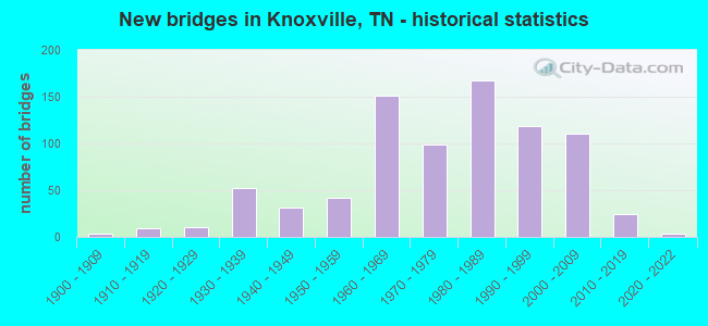
- New bridges - historical statistics
- 1Before 1900
- 31900-1909
- 91910-1919
- 111920-1929
- 521930-1939
- 311940-1949
- 421950-1959
- 1511960-1969
- 991970-1979
- 1681980-1989
- 1191990-1999
- 1112000-2009
- 242010-2019
- 32020-2022
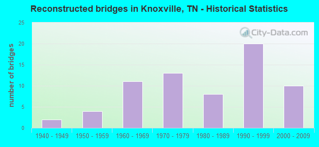
- Reconstructed bridges - Historical Statistics
- 21940-1949
- 41950-1959
- 111960-1969
- 131970-1979
- 81980-1989
- 201990-1999
- 102000-2009
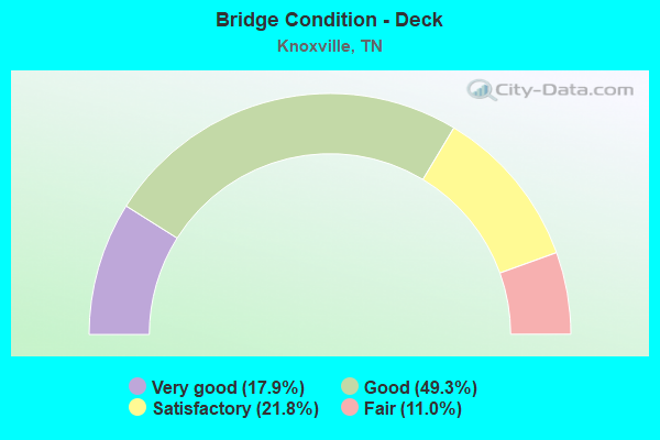
- Bridge Condition - Deck
- 17.9%Very good
- 49.3%Good
- 21.8%Satisfactory
- 11.0%Fair
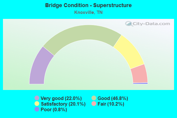
- Bridge Condition - Superstructure
- 22.0%Very good
- 46.8%Good
- 20.1%Satisfactory
- 10.2%Fair
- 0.8%Poor
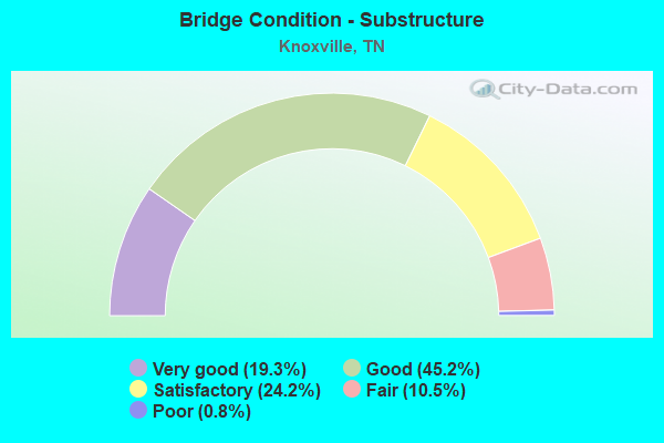
- Bridge Condition - Substructure
- 19.3%Very good
- 45.2%Good
- 24.2%Satisfactory
- 10.5%Fair
- 0.8%Poor
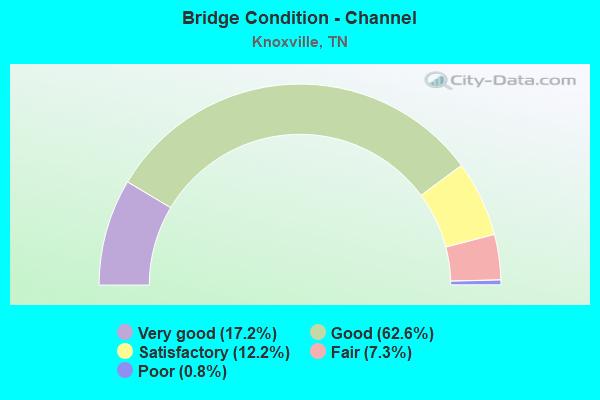
- Bridge Condition - Channel
- 17.2%Very good
- 62.6%Good
- 12.2%Satisfactory
- 7.3%Fair
- 0.8%Poor
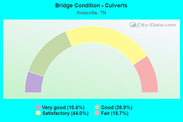
- Bridge Condition - Culverts
- 10.4%Very good
- 26.9%Good
- 44.0%Satisfactory
- 18.7%Fair
Find on map >> Show street view
Structure Number: 47I02750031, Location: CITY OF KNOXVILLE (Lat: 35.964767, Lng: -83.927567), Route carried "under" structure: City street 191, Year Built: 1994, Structure Length: 0. m, Average Daily Traffic: 1,000 (year 2022), Truck Traffic: 5%, Features Intersected: I275-SB RMP I /GRAND AVE, Facility Carried by Structure: I275 RAMP 5-I
Minimum Vertical Clearance: 7.63m (25.03ft), Kilometerpoint: 0.177, Lanes on structure: 1, Lanes under structure: 2, Material/Design: Steel continuous, Design/Construction: Stringer/Multi-beam, Length of Maximum Span: 45.7m (149.9ft)
Find on map >> Show street view
Structure Number: 47I02750033, Location: IN KNOXVILLE (Lat: 35.965950, Lng: -83.926367), Route carried "under" structure: City street 571, Year Built: 1986, Structure Length: 0. m, Average Daily Traffic: 3,300 (year 2022), Truck Traffic: 2%, Features Intersected: I275 RP 5C&D/WORLD FAIR, Facility Carried by Structure: I275 RAMP 5-D
Minimum Vertical Clearance: 6.56m (21.52ft), Kilometerpoint: 0.180, Lanes on structure: 1, Lanes under structure: 2, Material/Design: Steel continuous, Design/Construction: Stringer/Multi-beam, Length of Maximum Span: 54.7m (179.5ft)
Find on map >> Show street view
Structure Number: 47I02750033, Location: IN KNOXVILLE (Lat: 35.965950, Lng: -83.926367), Route carried "under" structure: City street 220, Year Built: 1986, Structure Length: 0. m, Average Daily Traffic: 1,426 (year 2020), Truck Traffic: 3%, Features Intersected: I275 RMP-5C&D/BLACKSTOCK, Facility Carried by Structure: I275 RAMP 5-D
Minimum Vertical Clearance: 7.63m (25.03ft), Kilometerpoint: 0.467, Lanes on structure: 1, Lanes under structure: 3, Material/Design: Steel continuous, Design/Construction: Stringer/Multi-beam, Length of Maximum Span: 54.7m (179.5ft)
Find on map >> Show street view
Structure Number: 47I02750033, Location: IN KNOXVILLE (Lat: 35.965950, Lng: -83.926367), Route carried "under" structure: Interstate 40, Year Built: 1986, Structure Length: 0. m, Average Daily Traffic: 104,800 (year 2020), Truck Traffic: 15%, Features Intersected: I275 RMP 5C&D/ I40-EB-RP, Facility Carried by Structure: I275 RAMP 5-D
Minimum Vertical Clearance: 5.42m (17.78ft), Kilometerpoint: 30.320, Lanes on structure: 1, Lanes under structure: 2, Material/Design: Steel continuous, Design/Construction: Stringer/Multi-beam, Length of Maximum Span: 54.7m (179.5ft)
Find on map >> Show street view
Structure Number: 47I02750033, Location: IN KNOXVILLE (Lat: 35.965950, Lng: -83.926367), Route carried "under" structure: Interstate 62, Year Built: 1986, Structure Length: 0. m, Average Daily Traffic: 13,893 (year 2020), Truck Traffic: 9%, Features Intersected: I275 RMP 5C&D/ SR62 RP, Facility Carried by Structure: I275 RAMP 5-D
Minimum Vertical Clearance: 7.63m (25.03ft), Kilometerpoint: 25.830, Lanes on structure: 1, Lanes under structure: 1, Material/Design: Steel continuous, Design/Construction: Stringer/Multi-beam, Length of Maximum Span: 54.7m (179.5ft)
Find on map >> Show street view
Structure Number: 47I02750033, Location: IN KNOXVILLE (Lat: 35.965950, Lng: -83.926367), Route carried "under" structure: Interstate 40, Year Built: 1986, Structure Length: 0. m, Average Daily Traffic: 122,095 (year 2020), Truck Traffic: 12%, Features Intersected: I275 RMP 5C&D/ I40-EB RP, Facility Carried by Structure: I275 RAMP 5-D
Minimum Vertical Clearance: 5.06m (16.60ft), Kilometerpoint: 29.934, Lanes on structure: 1, Lanes under structure: 7, Material/Design: Steel continuous, Design/Construction: Stringer/Multi-beam, Length of Maximum Span: 54.7m (179.5ft)
Find on map >> Show street view
Structure Number: 47I02750033, Location: IN KNOXVILLE (Lat: 35.965950, Lng: -83.926367), Route carried "under" structure: Interstate 40, Year Built: 1986, Structure Length: 0. m, Average Daily Traffic: 104,800 (year 2020), Truck Traffic: 15%, Features Intersected: I275 RMP 5C&D / I40, Facility Carried by Structure: I275 RAMP 5-D
Minimum Vertical Clearance: 7.63m (25.03ft), Kilometerpoint: 30.288, Lanes on structure: 1, Lanes under structure: 7, Material/Design: Steel continuous, Design/Construction: Stringer/Multi-beam, Length of Maximum Span: 54.7m (179.5ft)
Find on map >> Show street view
Structure Number: 47I02750033, Location: IN KNOXVILLE (Lat: 35.965950, Lng: -83.926367), Route carried "under" structure: Interstate 275, Year Built: 1986, Structure Length: 0. m, Average Daily Traffic: 64,369 (year 2020), Truck Traffic: 4%, Features Intersected: I275 RP 5C&D/I40E TOI275
Minimum Vertical Clearance: 7.12m (23.36ft), Kilometerpoint: 0.048, Lanes on structure: 1, Lanes under structure: 2, Material/Design: Steel continuous, Design/Construction: Stringer/Multi-beam, Length of Maximum Span: 54.7m (179.5ft)
Find on map >> Show street view
Structure Number: 47I06400003, Location: AT I640 (Lat: 36.000000, Lng: -83.956667), Route carried "under" structure: City street 1256, Year Built: 1960, Structure Length: 0. m, Average Daily Traffic: 7,713 (year 2020), Truck Traffic: 4%, Features Intersected: SOU. RR. / CENTRAL AVE., Facility Carried by Structure: SOU RWY 730641W
Minimum Vertical Clearance: 5.87m (19.26ft), Kilometerpoint: 4.860, Lanes under structure: 2, Material/Design: Steel continuous, Design/Construction: Stringer/Multi-beam, Length of Maximum Span: 24.7m (81.0ft)
Find on map >> Show street view
Structure Number: 47I06400003, Location: NEAR KNOXVILLE (Lat: 36.000000, Lng: -83.956667), Route carried "under" structure: Interstate 640, Year Built: 1963, Structure Length: 0. m, Average Daily Traffic: 87,049 (year 2020), Truck Traffic: 11%, Features Intersected: SOUTHERN RR. / I640
Minimum Vertical Clearance: 4.91m (16.11ft), Kilometerpoint: 0.290, Lanes under structure: 7, Material/Design: Steel, Design/Construction: Stringer/Multi-beam, Length of Maximum Span: 17.4m (57.1ft)
Find on map >> Show street view
Structure Number: 47I06400005, Location: EAST OF SHARPES GAP (Lat: 36.003850, Lng: -83.954017), Route carried "under" structure: Interstate 640, Year Built: 2002, Structure Length: 0. m, Average Daily Traffic: 87,049 (year 2020), Truck Traffic: 11%, Features Intersected: BRUHIN RD. / I640, Facility Carried by Structure: FAU 1256
Minimum Vertical Clearance: 4.78m (15.68ft), Kilometerpoint: 0.531, Lanes on structure: 6, Lanes under structure: 6, Material/Design: Prestressed concrete, Design/Construction: Stringer/Multi-beam, Length of Maximum Span: 47.2m (154.9ft)
Find on map >> Show street view
Structure Number: 47I06400007, Location: EAST OF SHARPES GAP (Lat: 36.008333, Lng: -83.938333), Route carried "under" structure: Interstate 640, Year Built: 1971, Structure Length: 0. m, Average Daily Traffic: 87,049 (year 2020), Truck Traffic: 11%, Features Intersected: THE HAGUE DR. / I640, Facility Carried by Structure: NFA B225
Minimum Vertical Clearance: 4.75m (15.58ft), Kilometerpoint: 2.157, Lanes on structure: 2, Lanes under structure: 4, Material/Design: Concrete continuous, Design/Construction: Tee Beam, Length of Maximum Span: 20.1m (65.9ft)
Find on map >> Show street view
Structure Number: 47I06400009, Location: W OF I640-SR33 EXCHANGE (Lat: 36.017600, Lng: -83.924083), Route carried "under" structure: City street 5648, Year Built: 1971, Structure Length: 0. m, Average Daily Traffic: 8,575 (year 2020), Truck Traffic: 4%, Features Intersected: I640 / OLD BROADWAY, Facility Carried by Structure: I640 RL
Minimum Vertical Clearance: 4.91m (16.11ft), Kilometerpoint: 2.765, Lanes on structure: 2, Lanes under structure: 4, Material/Design: Steel continuous, Design/Construction: Stringer/Multi-beam, Length of Maximum Span: 17.5m (57.4ft)
Find on map >> Show street view
Structure Number: 47I06400013, Location: IN KNOXVILLE (Lat: 36.018783, Lng: -83.922350), Route carried "under" structure: State highway 33, Year Built: 1970, Structure Length: 0. m, Average Daily Traffic: 15,315 (year 2020), Truck Traffic: 9%, Features Intersected: I640 / SR33, Facility Carried by Structure: I640
Minimum Vertical Clearance: 4.95m (16.24ft), Kilometerpoint: 18.298, Lanes on structure: 6, Lanes under structure: 6, Material/Design: Steel continuous, Design/Construction: Stringer/Multi-beam, Length of Maximum Span: 28.5m (93.5ft)
Find on map >> Show street view
Structure Number: 47I06400019, Location: NE OF SR 33 EXCHANGE (Lat: 36.021417, Lng: -83.914283), Route carried "under" structure: City street 326, Year Built: 1981, Structure Length: 0. m, Average Daily Traffic: 30 (year 2022), Truck Traffic: 2%, Features Intersected: I640-EB / SOU RR-NORA LN, Facility Carried by Structure: I640 RL
Minimum Vertical Clearance: 6.71m (22.01ft), Kilometerpoint: 0.323, Lanes on structure: 3, Lanes under structure: 2, Material/Design: Steel continuous, Design/Construction: Stringer/Multi-beam, Length of Maximum Span: 61.0m (200.1ft)
Find on map >> Show street view
Structure Number: 47I0640002, Location: NE OF SR33 EXCHANGE (Lat: 36.021650, Lng: -83.914050), Route carried "under" structure: City street 326, Year Built: 1981, Structure Length: 0. m, Average Daily Traffic: 30 (year 2022), Truck Traffic: 2%, Features Intersected: I640-WB / SOU RR-NORA LN, Facility Carried by Structure: I640 LL
Minimum Vertical Clearance: 7.63m (25.03ft), Kilometerpoint: 0.299, Lanes on structure: 3, Lanes under structure: 2, Material/Design: Steel continuous, Design/Construction: Stringer/Multi-beam, Length of Maximum Span: 61.0m (200.1ft)
Find on map >> Show street view
Structure Number: 47I06400021, Location: EAST OF SR 33 (Lat: 36.031950, Lng: -83.886383), Route carried "under" structure: City street 3779, Year Built: 1981, Structure Length: 0. m, Average Daily Traffic: 10,214 (year 2020), Truck Traffic: 4%, Features Intersected: I640-RL / WASHINGTON PK., Facility Carried by Structure: I640 RL
Minimum Vertical Clearance: 5.34m (17.52ft), Kilometerpoint: 0.008, Lanes on structure: 3, Lanes under structure: 4, Material/Design: Concrete continuous, Design/Construction: Box Beam or Girders - Multiple, Length of Maximum Span: 34.1m (111.9ft)
Find on map >> Show street view
Structure Number: 47I06400022, Location: EAST OF SR 33 (Lat: 36.032183, Lng: -83.886617), Route carried "under" structure: City street 1289, Year Built: 1981, Structure Length: 0. m, Average Daily Traffic: 19,908 (year 2020), Truck Traffic: 4%, Features Intersected: I640-LL / WASHINGTON PK., Facility Carried by Structure: I640 LL
Minimum Vertical Clearance: 5.11m (16.77ft), Kilometerpoint: 0.016, Lanes on structure: 3, Lanes under structure: 4, Material/Design: Concrete continuous, Design/Construction: Box Beam or Girders - Multiple, Length of Maximum Span: 34.1m (111.9ft)
Find on map >> Show street view
Structure Number: 47I06400023, Location: E. OF WASHINGTON PIKE (Lat: 36.030483, Lng: -83.879900), Route carried "under" structure: Interstate 640, Year Built: 1981, Structure Length: 0. m, Average Daily Traffic: 66,065 (year 2020), Truck Traffic: 14%, Features Intersected: EAST TOWNE RD. W. / I640, Facility Carried by Structure: NFA G306
Minimum Vertical Clearance: 5.09m (16.70ft), Kilometerpoint: 8.143, Lanes on structure: 3, Lanes under structure: 6, Material/Design: Concrete continuous, Design/Construction: Box Beam or Girders - Multiple, Length of Maximum Span: 36.0m (118.1ft)
Find on map >> Show street view
Structure Number: 47I06400025, Location: E. OF WASHINGTON PIKE (Lat: 36.030417, Lng: -83.878583), Route carried "under" structure: Interstate 640, Year Built: 1981, Structure Length: 0. m, Average Daily Traffic: 66,065 (year 2020), Truck Traffic: 14%, Features Intersected: EAST TOWNE RD. E. / I640, Facility Carried by Structure: NFA G305
Minimum Vertical Clearance: 5.31m (17.42ft), Kilometerpoint: 8.256, Lanes on structure: 3, Lanes under structure: 6, Material/Design: Concrete continuous, Design/Construction: Box Beam or Girders - Multiple, Length of Maximum Span: 32.9m (107.9ft)
Find on map >> Show street view
Structure Number: 47I06400027, Location: NW OF US 11W (Lat: 36.029950, Lng: -83.871700), Route carried "under" structure: Interstate 640, Year Built: 1981, Structure Length: 0. m, Average Daily Traffic: 66,065 (year 2020), Truck Traffic: 14%, Features Intersected: MILLERTOWN PK. / I640, Facility Carried by Structure: FAU 3773
Minimum Vertical Clearance: 4.93m (16.17ft), Kilometerpoint: 8.868, Lanes on structure: 5, Lanes under structure: 6, Material/Design: Concrete continuous, Design/Construction: Box Beam or Girders - Multiple, Length of Maximum Span: 39.6m (129.9ft)
Find on map >> Show street view
Structure Number: 47I06400031, Location: NW OF US 11W (Lat: 36.028267, Lng: -83.865300), Route carried "under" structure: Interstate 640, Year Built: 1981, Structure Length: 0. m, Average Daily Traffic: 66,065 (year 2020), Truck Traffic: 14%, Features Intersected: BUFFAT MILL DR. / I640, Facility Carried by Structure: NFA A115
Minimum Vertical Clearance: 4.81m (15.78ft), Kilometerpoint: 9.463, Lanes on structure: 2, Lanes under structure: 6, Material/Design: Concrete continuous, Design/Construction: Box Beam or Girders - Multiple, Length of Maximum Span: 41.8m (137.1ft)
Find on map >> Show street view
Structure Number: 47I06400033, Location: JUST N OF I40-I640 EXCH. (Lat: 36.020600, Lng: -83.860783), Route carried "under" structure: City street 443, Year Built: 1981, Structure Length: 0. m, Average Daily Traffic: 300 (year 2022), Truck Traffic: 5%, Features Intersected: I640-RL / MCINTYRE RD., Facility Carried by Structure: I640 RL
Minimum Vertical Clearance: 5.26m (17.26ft), Kilometerpoint: 0.885, Lanes on structure: 3, Lanes under structure: 2, Material/Design: Prestressed concrete, Design/Construction: Box Beam or Girders - Single/Spread, Length of Maximum Span: 25.6m (84.0ft)
Find on map >> Show street view
Structure Number: 47I06400034, Location: JUST N OF I40-I640 EXCH. (Lat: 36.020533, Lng: -83.860533), Route carried "under" structure: City street 443, Year Built: 1981, Structure Length: 0. m, Average Daily Traffic: 300 (year 2022), Truck Traffic: 5%, Features Intersected: I640-LL / MCINTYRE RD., Facility Carried by Structure: I640 LF LN
Minimum Vertical Clearance: 7.63m (25.03ft), Kilometerpoint: 0.921, Lanes on structure: 4, Lanes under structure: 2, Material/Design: Prestressed concrete, Design/Construction: Box Beam or Girders - Single/Spread, Length of Maximum Span: 25.6m (84.0ft)
Find on map >> Show street view
Structure Number: 47I06400035, Location: JUST N. OF I-40 JCT. (Lat: 36.017150, Lng: -83.861433), Route carried "under" structure: US 11, Year Built: 1982, Structure Length: 0. m, Average Daily Traffic: 18,313 (year 2020), Truck Traffic: 9%, Features Intersected: I640-RL / SR 1-SOU. RR., Facility Carried by Structure: I640 RL
Minimum Vertical Clearance: 7.63m (25.03ft), Kilometerpoint: 41.347, Lanes on structure: 4, Lanes under structure: 4, Material/Design: Steel continuous, Design/Construction: Stringer/Multi-beam, Length of Maximum Span: 40.3m (132.2ft)
Find on map >> Show street view
Structure Number: 47I06400036, Location: JUST N. OF I-40 JCT. (Lat: 36.017250, Lng: -83.861033), Route carried "under" structure: US 11, Year Built: 1982, Structure Length: 0. m, Average Daily Traffic: 18,313 (year 2020), Truck Traffic: 9%, Features Intersected: I640-LL / SR 1-SOU. RR., Facility Carried by Structure: I640 LL
Minimum Vertical Clearance: 7.63m (25.03ft), Kilometerpoint: 41.396, Lanes on structure: 4, Lanes under structure: 4, Material/Design: Steel continuous, Design/Construction: Stringer/Multi-beam, Length of Maximum Span: 40.3m (132.2ft)
Find on map >> Show street view
Structure Number: 47I06400037, Location: 1 M SE OF WHITTLE SPRINGS (Lat: 36.020000, Lng: -83.921111), Route carried "under" structure: Ramp Interstate SR033, Year Built: 2018, Structure Length: 0. m, Average Daily Traffic: 33,346 (year 2020), Truck Traffic: 9%, Features Intersected: I640E RAMP / SR33
Minimum Vertical Clearance: 5.18m (16.99ft), Kilometerpoint: 18.717, Lanes on structure: 1, Lanes under structure: 1, Material/Design: Prestressed concrete, Design/Construction: Stringer/Multi-beam, Length of Maximum Span: 28.0m (91.9ft)
Find on map >> Show street view
Structure Number: 47L37750001, Location: DOWNTOWN KNOXVILLE (Lat: 35.958533, Lng: -83.914583), Route carried "under" structure: State highway 1, Year Built: 1945, Structure Length: 0. m, Average Daily Traffic: 12,902 (year 2020), Truck Traffic: 9%, Features Intersected: GAY ST. / SR001, Facility Carried by Structure: FAU 3775
Minimum Vertical Clearance: 5.75m (18.86ft), Kilometerpoint: 32.203, Lanes on structure: 4, Lanes under structure: 4, Material/Design: Steel continuous, Design/Construction: Truss - Thru, Length of Maximum Span: 76.8m (252.0ft)
Find on map >> Show street view
Structure Number: 47L37750001, Location: DOWNTOWN KNOXVILLE (Lat: 35.958467, Lng: -83.914817), Route carried "under" structure: State highway SR001, Year Built: 1945, Structure Length: 0. m, Average Daily Traffic: 12,902 (year 2020), Truck Traffic: 9%, Features Intersected: GAY ST. / SR001, Facility Carried by Structure: FAU 3775
Minimum Vertical Clearance: 7.63m (25.03ft), Kilometerpoint: 32.219, Lanes on structure: 4, Lanes under structure: 1, Material/Design: Steel continuous, Design/Construction: Truss - Thru, Length of Maximum Span: 76.8m (252.0ft)
Find on map >> Show street view
Structure Number: 47L37750005, Location: CITY OF KNOXVILLE (Lat: 35.955750, Lng: -83.914167), Route carried "under" structure: City street 3775, Year Built: 1992, Structure Length: 0. m, Average Daily Traffic: 6,704 (year 2020), Truck Traffic: 4%, Features Intersected: PED. WALK / E. BLOUNT AV
Minimum Vertical Clearance: 7.63m (25.03ft), Kilometerpoint: 0.193, Lanes under structure: 5, Material/Design: Prestressed concrete continuous, Design/Construction: Box Beam or Girders - Single/Spread, Length of Maximum Span: 24.1m (79.1ft)
Find on map >> Show street view
Structure Number: 47S24080001, Location: STRAWBERRY PLNS RD/HOLSTN (Lat: 35.984817, Lng: -83.856233), Route carried "under" structure: County highway 794, Year Built: 1945, Structure Length: 0. m, Average Daily Traffic: 200 (year 2022), Truck Traffic: 2%, Features Intersected: STRAWBERRY/ RIVER SHORES, Facility Carried by Structure: FAU 1124
Minimum Vertical Clearance: 7.63m (25.03ft), Kilometerpoint: 0.803, Lanes on structure: 2, Lanes under structure: 2, Material/Design: Steel continuous, Design/Construction: Truss - Thru, Length of Maximum Span: 61.0m (200.1ft)
Find on map >> Show street view
Structure Number: 47S25050005, Location: JUST N OF HOLSTON RIVER (Lat: 36.060733, Lng: -83.703917), Route carried "under" structure: County highway 1262, Year Built: 1984, Structure Length: 0. m, Average Daily Traffic: 8,306 (year 2020), Truck Traffic: 3%, Features Intersected: SOUTHERN RR / MASCOT PK, Facility Carried by Structure: SOU RWY 731446A
Minimum Vertical Clearance: 5.03m (16.50ft), Kilometerpoint: 8.208, Lanes under structure: 2, Material/Design: Steel, Design/Construction: Stringer/Multi-beam, Length of Maximum Span: 25.6m (84.0ft)
Find on map >> Show street view
Structure Number: 47S25910001, Location: NE OF US441-SR168 JCT (Lat: 35.914117, Lng: -83.830717), Route carried "under" structure: County highway 5903, Year Built: 1968, Structure Length: 0. m, Average Daily Traffic: 963 (year 2020), Truck Traffic: 4%, Features Intersected: SR168 / SEVIERVILLE PK, Facility Carried by Structure: FAU 168
Minimum Vertical Clearance: 4.50m (14.76ft), Kilometerpoint: 5.029, Lanes on structure: 2, Lanes under structure: 2, Material/Design: Prestressed concrete, Design/Construction: Stringer/Multi-beam, Length of Maximum Span: 11.9m (39.0ft)
Find on map >> Show street view
Structure Number: 47S25910005, Location: NE OF SR168-US441 JCT (Lat: 35.920350, Lng: -83.824833), Route carried "under" structure: County highway 159, Year Built: 1970, Structure Length: 0. m, Average Daily Traffic: 330 (year 2022), Truck Traffic: 2%, Features Intersected: SR168 / BURNETT CREEK RD, Facility Carried by Structure: FAS 168
Minimum Vertical Clearance: 4.63m (15.19ft), Kilometerpoint: 4.519, Lanes on structure: 2, Lanes under structure: 2, Material/Design: Prestressed concrete, Design/Construction: Stringer/Multi-beam, Length of Maximum Span: 11.9m (39.0ft)
Find on map >> Show street view
Structure Number: 47S25910015, Location: W OF SR168-US441 JCT (Lat: 35.898483, Lng: -83.873517), Route carried "under" structure: County highway 40, Year Built: 1975, Structure Length: 0. m, Average Daily Traffic: 1,000 (year 2022), Truck Traffic: 2%, Features Intersected: SR 168 / NUBERT SPGS. RD, Facility Carried by Structure: FAS 168
Minimum Vertical Clearance: 4.50m (14.76ft), Kilometerpoint: 0.000, Lanes on structure: 2, Lanes under structure: 2, Material/Design: Prestressed concrete continuous, Design/Construction: Stringer/Multi-beam, Length of Maximum Span: 17.1m (56.1ft)
Find on map >> Show street view
Structure Number: 47SR0010013, Location: NEAR KNOXVILLE TENN. (Lat: 35.952567, Lng: -83.942350), Route carried "under" structure: City street 6024, Year Built: 2000, Structure Length: 0. m, Average Daily Traffic: 17,937 (year 2020), Truck Traffic: 9%, Features Intersected: SR115-ALCOA / KINGSTON, Facility Carried by Structure: FAP 115
Minimum Vertical Clearance: 5.19m (17.03ft), Kilometerpoint: 0.402, Lanes on structure: 7, Lanes under structure: 5, Material/Design: Steel, Design/Construction: Stringer/Multi-beam, Length of Maximum Span: 43.3m (142.1ft)
Find on map >> Show street view
Structure Number: 47SR0010019, Location: NEAR KNOXVILLE TENN. (Lat: 35.953400, Lng: -83.940517), Route carried "under" structure: City street 6024, Year Built: 1961, Structure Length: 0. m, Average Daily Traffic: 17,937 (year 2020), Truck Traffic: 9%, Features Intersected: CSX RR / CUMBERLAND AVE, Facility Carried by Structure: CSX RR 347576P
Minimum Vertical Clearance: 4.20m (13.78ft), Kilometerpoint: 0.644, Lanes under structure: 4, Material/Design: Steel, Design/Construction: Stringer/Multi-beam, Length of Maximum Span: 19.5m (64.0ft)
Find on map >> Show street view
Structure Number: 47SR0010021, Location: UT CAMPUS BRIDGE (Lat: 35.956967, Lng: -83.931050), Route carried "under" structure: City street 6024, Year Built: 1961, Structure Length: 0. m, Average Daily Traffic: 14,511 (year 2020), Truck Traffic: 9%, Features Intersected: PED WALK / CUMBERLAND AV, Facility Carried by Structure: PEDESTRAIN WALKWAY
Minimum Vertical Clearance: 4.47m (14.67ft), Kilometerpoint: 1.577, Lanes under structure: 4, Material/Design: Concrete, Design/Construction: Tee Beam, Length of Maximum Span: 26.4m (86.6ft)
Find on map >> Show street view
Structure Number: 47SR0010023, Location: IN KNOXVILLE (Lat: 35.959333, Lng: -83.923400), Route carried "under" structure: City street 6024, Year Built: 1950, Structure Length: 0. m, Average Daily Traffic: 10,939 (year 2020), Truck Traffic: 9%, Features Intersected: SOU RR / CUMBERLAND AVE, Facility Carried by Structure: SOU RWY 347640L
Minimum Vertical Clearance: 4.88m (16.01ft), Kilometerpoint: 2.334, Lanes under structure: 4, Material/Design: Steel, Design/Construction: Stringer/Multi-beam, Length of Maximum Span: 19.5m (64.0ft)
Find on map >> Show street view
Structure Number: 47SR0010035, Location: NEAR KNOXVILLE TENN. (Lat: 36.001867, Lng: -83.874750), Route carried "under" structure: US 11, Year Built: 1958, Structure Length: 0. m, Average Daily Traffic: 9,122 (year 2020), Truck Traffic: 9%, Features Intersected: ASHEVILLE HWY/ RUTHLEDGE, Facility Carried by Structure: FAP 168
Minimum Vertical Clearance: 4.45m (14.60ft), Kilometerpoint: 39.159, Lanes on structure: 1, Lanes under structure: 1, Material/Design: Steel, Design/Construction: Stringer/Multi-beam, Length of Maximum Span: 17.5m (57.4ft)
Find on map >> Show street view
Structure Number: 47SR0010051, Location: 2 BLOCKS W OF SR33 (Lat: 35.959350, Lng: -83.923250), Route carried "under" structure: City street 6024, Year Built: 1982, Structure Length: 0. m, Average Daily Traffic: 10,939 (year 2020), Truck Traffic: 9%, Features Intersected: PED WALK / CUMBERLAND AV, Facility Carried by Structure: PEDESTRAIN WALKWAY
Minimum Vertical Clearance: 5.63m (18.47ft), Kilometerpoint: 2.350, Lanes under structure: 4, Material/Design: Prestressed concrete, Design/Construction: Box Beam or Girders - Single/Spread, Length of Maximum Span: 20.4m (66.9ft)
Find on map >> Show street view
Structure Number: 47SR0010055, Location: 2 BLOCKS W OF SR33 (Lat: 35.959350, Lng: -83.923233), Route carried "under" structure: City street 6024, Year Built: 1982, Structure Length: 0. m, Average Daily Traffic: 10,939 (year 2020), Truck Traffic: 9%, Features Intersected: PED WALK / CUMBERLAND AV, Facility Carried by Structure: PEDESTRAIN WALKWAY
Minimum Vertical Clearance: 5.15m (16.90ft), Kilometerpoint: 2.366, Lanes under structure: 4, Material/Design: Prestressed concrete, Design/Construction: Box Beam or Girders - Single/Spread, Length of Maximum Span: 20.4m (66.9ft)
Find on map >> Show street view
Structure Number: 47SR0010057, Location: 2 BLOCKS N OF SR33 SPLIT (Lat: 35.962567, Lng: -83.921767), Route carried "under" structure: US 11, Year Built: 1981, Structure Length: 0. m, Average Daily Traffic: 32,431 (year 2020), Truck Traffic: 9%, Features Intersected: PED WALK / HENLEY ST., Facility Carried by Structure: PEDESTRAIN WALKWAY
Minimum Vertical Clearance: 4.98m (16.34ft), Kilometerpoint: 11.700, Lanes under structure: 6, Material/Design: Steel, Design/Construction: Stringer/Multi-beam, Length of Maximum Span: 46.6m (152.9ft)
Find on map >> Show street view
Structure Number: 47SR0010061, Location: CITY OF KNOXVILLE (Lat: 35.967867, Lng: -83.927417), Route carried "under" structure: City street 1, Year Built: 1986, Structure Length: 0. m, Average Daily Traffic: 1,000 (year 2022), Truck Traffic: 2%, Features Intersected: SR1(HENLEY ST) / OAK ST.
Minimum Vertical Clearance: 7.57m (24.84ft), Kilometerpoint: 0.032, Lanes on structure: 1, Lanes under structure: 4, Material/Design: Steel continuous, Design/Construction: Stringer/Multi-beam, Length of Maximum Span: 47.4m (155.5ft)
Find on map >> Show street view
Structure Number: 47SR0010061, Location: CITY OF KNOXVILLE (Lat: 35.966050, Lng: -83.925650), Route carried "under" structure: City street 571, Year Built: 1986, Structure Length: 0. m, Average Daily Traffic: 1,000 (year 2022), Truck Traffic: 2%, Features Intersected: SR1 / WORLD'S FAIR PARK, Facility Carried by Structure: FAP 1 RAMP 5-F
Minimum Vertical Clearance: 5.19m (17.03ft), Kilometerpoint: 0.209, Lanes on structure: 1, Lanes under structure: 2, Material/Design: Steel continuous, Design/Construction: Stringer/Multi-beam, Length of Maximum Span: 47.4m (155.5ft)
Find on map >> Show street view
Structure Number: 47SR0010065, Location: CITY OF KNOXVILLE (Lat: 35.964617, Lng: -83.924133), Route carried "under" structure: Ramp State highway 33, Year Built: 1994, Structure Length: 0. m, Average Daily Traffic: 32,431 (year 2020), Truck Traffic: 9%, Features Intersected: SR62 /SR RP-C HENLEY ST, Facility Carried by Structure: FAP 62
Minimum Vertical Clearance: 5.03m (16.50ft), Kilometerpoint: 11.990, Lanes on structure: 6, Lanes under structure: 2, Material/Design: Prestressed concrete, Design/Construction: Box Beam or Girders - Single/Spread, Length of Maximum Span: 20.7m (67.9ft)
Find on map >> Show street view
Structure Number: 47SR0010069, Location: UT CAMPUS (Lat: 35.959019, Lng: -83.925494), Route carried "under" structure: City street 6024, Year Built: 1990, Structure Length: 0. m, Average Daily Traffic: 10,939 (year 2020), Truck Traffic: 9%, Features Intersected: PED WALK / CUMBERLAND AV, Facility Carried by Structure: PEDESTRAIN WALKWAY
Minimum Vertical Clearance: 7.62m (25.00ft), Kilometerpoint: 2.140, Lanes under structure: 4, Material/Design: Steel, Design/Construction: Truss - Thru, Length of Maximum Span: 27.2m (89.2ft)
Find on map >> Show street view
Structure Number: 47SR0010071, Location: DOWNTOWN KNOXVILLE (Lat: 35.975950, Lng: -83.916742), Route carried "under" structure: City street 6025, Year Built: 2007, Structure Length: 0. m, Average Daily Traffic: 4,955 (year 2020), Truck Traffic: 9%, Features Intersected: NEYLAND DR / E. FIFTH AV, Facility Carried by Structure: FAP 158
Minimum Vertical Clearance: 7.63m (25.03ft), Kilometerpoint: 0.748, Lanes on structure: 2, Lanes under structure: 6, Material/Design: Prestressed concrete continuous, Design/Construction: Box Beam or Girders - Single/Spread, Length of Maximum Span: 32.0m (105.0ft)
Find on map >> Show street view
Structure Number: 47SR0090003, Location: IN KNOXVILLE (Lat: 36.006983, Lng: -83.850667), Route carried "under" structure: US 168, Year Built: 1970, Structure Length: 0. m, Average Daily Traffic: 9,617 (year 2020), Truck Traffic: 9%, Features Intersected: PED WALK / SR168, Facility Carried by Structure: PEDESTRAIN WALKWAY
Minimum Vertical Clearance: 4.48m (14.70ft), Kilometerpoint: 26.546, Lanes under structure: 5, Material/Design: Steel, Design/Construction: Frame, Length of Maximum Span: 33.1m (108.6ft)
Find on map >> Show street view
Structure Number: 47SR0090015, Location: AT SHARPS GAP EXCHANGE (Lat: 35.998717, Lng: -83.960600), Route carried "under" structure: US 25, Year Built: 1981, Structure Length: 0. m, Average Daily Traffic: 21,926 (year 2020), Truck Traffic: 9%, Features Intersected: SR9 RMP TO I75-SB / SR9, Facility Carried by Structure: SR 9
Minimum Vertical Clearance: 4.98m (16.34ft), Kilometerpoint: 11.217, Lanes on structure: 1, Lanes under structure: 5, Material/Design: Steel continuous, Design/Construction: Stringer/Multi-beam, Length of Maximum Span: 28.0m (91.9ft)
Find on map >> Show street view
Structure Number: 47SR0330005, Location: NEAR KNOXVILLE TENN. (Lat: 35.912050, Lng: -83.937067), Route carried "under" structure: State highway 33, Year Built: 1943, Structure Length: 0. m, Average Daily Traffic: 5,819 (year 2020), Truck Traffic: 1%, Features Intersected: CSX RR / MARYVILLE PK., Facility Carried by Structure: CSX RR 347586V
Minimum Vertical Clearance: 3.89m (12.76ft), Kilometerpoint: 4.828, Lanes under structure: 4, Material/Design: Concrete, Design/Construction: Tee Beam, Length of Maximum Span: 6.1m (20.0ft)
Find on map >> Show street view
Structure Number: 47SR0330009, Location: NEAR KNOXVILLE TENN. (Lat: 35.930617, Lng: -83.917783), Route carried "under" structure: State highway 33, Year Built: 1971, Structure Length: 0. m, Average Daily Traffic: 5,819 (year 2020), Truck Traffic: 1%, Features Intersected: SOUTHERN RR / MARYVILLE, Facility Carried by Structure: SOU RWY 730419A
Minimum Vertical Clearance: 3.10m (10.17ft), Kilometerpoint: 7.661, Lanes under structure: 2, Material/Design: Steel, Design/Construction: Stringer/Multi-beam, Length of Maximum Span: 7.0m (23.0ft)
Find on map >> Show street view
Structure Number: 47SR0330011, Location: SOUTH OF KNOXVILLE (Lat: 35.956667, Lng: -83.920000), Route carried "under" structure: State highway 1, Year Built: 1930, Structure Length: 0. m, Average Daily Traffic: 12,902 (year 2020), Truck Traffic: 9%, Features Intersected: SR 33 / NEYLAND DR., Facility Carried by Structure: FAU 33
Minimum Vertical Clearance: 6.25m (20.51ft), Kilometerpoint: 31.769, Lanes on structure: 5, Lanes under structure: 4, Material/Design: Concrete, Design/Construction: Arch - Deck, Length of Maximum Span: 96.6m (316.9ft)
Find on map >> Show street view
Structure Number: 47SR0330011, Location: CITY OF KNOXVILLE (Lat: 35.958867, Lng: -83.919883), Route carried "under" structure: City street 183, Year Built: 1930, Structure Length: 0. m, Average Daily Traffic: 100 (year 2022), Truck Traffic: 1%, Features Intersected: SR 33 / FRONT AVE
Minimum Vertical Clearance: 7.63m (25.03ft), Kilometerpoint: 0.200, Lanes on structure: 5, Lanes under structure: 2, Material/Design: Concrete, Design/Construction: Arch - Deck, Length of Maximum Span: 96.6m (316.9ft)
Find on map >> Show street view
Structure Number: 47SR0330013, Location: IN KNOXVILLE (Lat: 35.987183, Lng: -83.921017), Route carried "under" structure: Ramp State highway 33, Year Built: 1966, Structure Length: 0. m, Average Daily Traffic: 13,243 (year 2020), Truck Traffic: 9%, Features Intersected: BROADWAY / SR158
Minimum Vertical Clearance: 4.58m (15.03ft), Kilometerpoint: 0.547, Lanes on structure: 4, Lanes under structure: 2, Material/Design: Concrete, Design/Construction: Box Beam or Girders - Multiple, Length of Maximum Span: 18.6m (61.0ft)
Find on map >> Show street view
Structure Number: 47SR0330025, Location: NEAR KNOXVILLE TENN. (Lat: 36.016583, Lng: -83.922550), Route carried "under" structure: US 441, Year Built: 1971, Structure Length: 0. m, Average Daily Traffic: 15,315 (year 2020), Truck Traffic: 9%, Features Intersected: SOUTHERN RR / BROADWAY, Facility Carried by Structure: SOU RWY 730471E
Minimum Vertical Clearance: 4.52m (14.83ft), Kilometerpoint: 18.089, Lanes under structure: 5, Material/Design: Steel, Design/Construction: Stringer/Multi-beam, Length of Maximum Span: 36.9m (121.1ft)
Find on map >> Show street view
Structure Number: 47SR0330029, Location: JUST NORTH OF I640 (Lat: 36.022317, Lng: -83.924517), Route carried "under" structure: State highway 331, Year Built: 1971, Structure Length: 0. m, Average Daily Traffic: 14,856 (year 2020), Truck Traffic: 4%, Features Intersected: SR 33/SR331(TAZEWELL PK), Facility Carried by Structure: FAP 33
Minimum Vertical Clearance: 4.17m (13.68ft), Kilometerpoint: 0.000, Lanes on structure: 4, Lanes under structure: 3, Material/Design: Steel continuous, Design/Construction: Stringer/Multi-beam, Length of Maximum Span: 28.3m (92.8ft)
Find on map >> Show street view
Structure Number: 47SR0330037, Location: SOUTH OF KNOXVILLE (Lat: 35.888200, Lng: -83.937583), Route carried "under" structure: State highway 33, Year Built: 1970, Structure Length: 0. m, Average Daily Traffic: 7,736 (year 2020), Truck Traffic: 4%, Features Intersected: SR168 / MARYVILLE PK., Facility Carried by Structure: FAS 168
Minimum Vertical Clearance: 4.45m (14.60ft), Kilometerpoint: 1.963, Lanes on structure: 3, Lanes under structure: 2, Material/Design: Prestressed concrete, Design/Construction: Stringer/Multi-beam, Length of Maximum Span: 21.5m (70.5ft)
Find on map >> Show street view
Structure Number: 47SR0330039, Location: CITY OF KNOXVILLE (Lat: 35.964567, Lng: -83.923283), Route carried "under" structure: Ramp State highway 33, Year Built: 1994, Structure Length: 0. m, Average Daily Traffic: 32,431 (year 2020), Truck Traffic: 9%, Features Intersected: SR62 /SR33RP-G HENLEY ST, Facility Carried by Structure: FAP 62
Minimum Vertical Clearance: 5.09m (16.70ft), Kilometerpoint: 11.941, Lanes on structure: 6, Lanes under structure: 2, Material/Design: Prestressed concrete, Design/Construction: Box Beam or Girders - Single/Spread, Length of Maximum Span: 27.1m (88.9ft)
Find on map >> Show street view
Structure Number: 47SR0333001, Location: N. OF I40 (Lat: 35.985550, Lng: -83.918950), Route carried "under" structure: County highway 33, Year Built: 1965, Structure Length: 0. m, Average Daily Traffic: 13,243 (year 2020), Truck Traffic: 9%, Features Intersected: GLENWOOD / HALL FAME DR., Facility Carried by Structure: NFA 5666
Minimum Vertical Clearance: 5.09m (16.70ft), Kilometerpoint: 0.290, Lanes on structure: 2, Lanes under structure: 4, Material/Design: Prestressed concrete continuous, Design/Construction: Stringer/Multi-beam, Length of Maximum Span: 30.8m (101.0ft)
Find on map >> Show street view
Structure Number: 47SR0620013, Location: DOWNTOWN KNOXVILLE (Lat: 35.964717, Lng: -83.930983), Route carried "under" structure: City street 220, Year Built: 1994, Structure Length: 0. m, Average Daily Traffic: 1,426 (year 2020), Truck Traffic: 3%, Features Intersected: SR 62 / BLACKSTOCK AVE., Facility Carried by Structure: FAU 62
Minimum Vertical Clearance: 6.66m (21.85ft), Kilometerpoint: 0.132, Lanes on structure: 4, Lanes under structure: 2, Material/Design: Steel continuous, Design/Construction: Stringer/Multi-beam, Length of Maximum Span: 51.2m (168.0ft)
Find on map >> Show street view
Structure Number: 47SR0620013, Location: JUST W OF SR 33 JCT. (Lat: 35.964267, Lng: -83.928583), Route carried "under" structure: City street 571, Year Built: 1940, Structure Length: 0. m, Average Daily Traffic: 10 (year 2022), Truck Traffic: 2%, Features Intersected: SR 62 / GRANDE AVE., Facility Carried by Structure: FAU 62
Minimum Vertical Clearance: 5.85m (19.19ft), Kilometerpoint: 0.616, Lanes on structure: 4, Lanes under structure: 2, Material/Design: Steel continuous, Design/Construction: Stringer/Multi-beam, Length of Maximum Span: 50.9m (167.0ft)
Find on map >> Show street view
Structure Number: 47SR0620015, Location: 1.4 M W OF I75 (Lat: 35.964483, Lng: -83.926833), Route carried "under" structure: City street 571, Year Built: 1994, Structure Length: 0. m, Average Daily Traffic: 50 (year 2022), Truck Traffic: 2%, Features Intersected: SR62/E571-GRAND AVE, Facility Carried by Structure: FAU 62
Minimum Vertical Clearance: 7.63m (25.03ft), Kilometerpoint: 0.380, Lanes on structure: 6, Lanes under structure: 2, Material/Design: Steel continuous, Design/Construction: Stringer/Multi-beam, Length of Maximum Span: 47.2m (154.9ft)
Find on map >> Show street view
Structure Number: 47SR0620015, Location: 1.4 M W OF I75 (Lat: 35.964633, Lng: -83.925817), Route carried "under" structure: City street 571, Year Built: 1994, Structure Length: 0. m, Average Daily Traffic: 50 (year 2022), Truck Traffic: 2%, Features Intersected: SR62/E571-JACKSON AVE, Facility Carried by Structure: FAU 62
Minimum Vertical Clearance: 5.11m (16.77ft), Kilometerpoint: 0.283, Lanes on structure: 6, Lanes under structure: 2, Material/Design: Steel continuous, Design/Construction: Stringer/Multi-beam, Length of Maximum Span: 47.2m (154.9ft)
Find on map >> Show street view
Structure Number: 47SR0620021, Location: WEST OF KNOXVILLE (Lat: 35.979367, Lng: -84.110050), Route carried "under" structure: State highway 62, Year Built: 1956, Structure Length: 0. m, Average Daily Traffic: 13,594 (year 2020), Truck Traffic: 9%, Features Intersected: PED WALK / SR62, Facility Carried by Structure: PED. WALKWAY
Minimum Vertical Clearance: 5.21m (17.09ft), Kilometerpoint: 8.433, Lanes under structure: 2, Material/Design: Steel continuous, Design/Construction: Stringer/Multi-beam, Length of Maximum Span: 29.2m (95.8ft)
Find on map >> Show street view
Structure Number: 47SR0620027, Location: A MILE WEST OF I-75/SR-62 (Lat: 35.975294, Lng: -84.107000), Route carried "under" structure: City street 6024, Year Built: 2018, Structure Length: 0. m, Average Daily Traffic: 14,511 (year 2020), Truck Traffic: 9%, Features Intersected: PED WALK / SR-62, Facility Carried by Structure: PEDESTRAIN WALKWAY
Minimum Vertical Clearance: 5.31m (17.42ft), Kilometerpoint: 1.577, Lanes under structure: 5, Material/Design: Concrete, Design/Construction: Tee Beam, Length of Maximum Span: 19.2m (63.0ft)
Find on map >> Show street view
Structure Number: 47SR0710005, Location: SE OF KNOXVILLE (Lat: 35.907667, Lng: -83.839883), Route carried "under" structure: US 441, Year Built: 1974, Structure Length: 0. m, Average Daily Traffic: 33,958 (year 2020), Truck Traffic: 9%, Features Intersected: SR 168 / CHAPMAN HWY., Facility Carried by Structure: FAS 168
Minimum Vertical Clearance: 4.65m (15.26ft), Kilometerpoint: 5.053, Lanes on structure: 2, Lanes under structure: 4, Material/Design: Prestressed concrete continuous, Design/Construction: Box Beam or Girders - Single/Spread, Length of Maximum Span: 38.0m (124.7ft)
Find on map >> Show street view
Structure Number: 47SR0710019, Location: EAST KNOXVILLE (Lat: 35.962833, Lng: -83.913800), Route carried "under" structure: State highway 158, Year Built: 1999, Structure Length: 0. m, Average Daily Traffic: 13,490 (year 2020), Truck Traffic: 9%, Features Intersected: RMP J WHITE PKWY/NEYLAND, Facility Carried by Structure: FAP 71
Minimum Vertical Clearance: 5.72m (18.77ft), Kilometerpoint: 0.225, Lanes on structure: 1, Lanes under structure: 4, Material/Design: Steel continuous, Design/Construction: Stringer/Multi-beam, Length of Maximum Span: 38.1m (125.0ft)
Find on map >> Show street view
Structure Number: 47SR0710021, Location: EAST KNOXVILLE (Lat: 35.963700, Lng: -83.912700), Route carried "under" structure: State highway SR634, Year Built: 1999, Structure Length: 0. m, Average Daily Traffic: 12,490 (year 2020), Truck Traffic: 13%, Features Intersected: J WHITE RMP / J WHITE, Facility Carried by Structure: FAP 71
Minimum Vertical Clearance: 5.21m (17.09ft), Kilometerpoint: 2.237, Lanes on structure: 1, Lanes under structure: 4, Material/Design: Steel continuous, Design/Construction: Stringer/Multi-beam, Length of Maximum Span: 34.8m (114.2ft)
Find on map >> Show street view
Structure Number: 47SR0710023, Location: EAST KNOXVILLE (Lat: 35.963717, Lng: -83.911967), Route carried "under" structure: Ramp State highway SR634, Year Built: 1999, Structure Length: 0. m, Average Daily Traffic: 12,490 (year 2020), Truck Traffic: 13%, Features Intersected: HALL FAME DR / J WHITE, Facility Carried by Structure: FAP 71
Minimum Vertical Clearance: 5.16m (16.93ft), Kilometerpoint: 2.157, Lanes on structure: 5, Lanes under structure: 5, Material/Design: Prestressed concrete continuous, Design/Construction: Box Beam or Girders - Single/Spread, Length of Maximum Span: 19.3m (63.3ft)
Find on map >> Show street view
Structure Number: 47SR0710025, Location: JAMES WHITE PARKWAY (Lat: 35.964467, Lng: -83.909867), Route carried "under" structure: State highway SR634, Year Built: 1999, Structure Length: 0. m, Average Daily Traffic: 12,490 (year 2020), Truck Traffic: 13%, Features Intersected: PED WALK / S KNOXVILLE, Facility Carried by Structure: FAP 71
Minimum Vertical Clearance: 7.63m (25.03ft), Kilometerpoint: 1.996, Lanes under structure: 7, Material/Design: Concrete continuous, Design/Construction: Stringer/Multi-beam, Length of Maximum Span: 27.4m (89.9ft)
Find on map >> Show street view
Structure Number: 47SR0710027, Location: SE OF KNOXVILLE (Lat: 35.965983, Lng: -83.907167), Route carried "under" structure: State highway SR634, Year Built: 1997, Structure Length: 0. m, Average Daily Traffic: 25,281 (year 2020), Truck Traffic: 9%, Features Intersected: EAST HILL AVE / SR71, Facility Carried by Structure: NFA 129
Minimum Vertical Clearance: 5.26m (17.26ft), Kilometerpoint: 7.886, Lanes on structure: 5, Lanes under structure: 4, Material/Design: Prestressed concrete continuous, Design/Construction: Box Beam or Girders - Single/Spread, Length of Maximum Span: 13.1m (43.0ft)
Find on map >> Show street view
Structure Number: 47SR0710029, Location: EAST KNOXVILLE (Lat: 35.965333, Lng: -83.900833), Route carried "under" structure: City street 1124, Year Built: 1999, Structure Length: 0. m, Average Daily Traffic: 4,047 (year 2020), Truck Traffic: 3%, Features Intersected: J WHITE PKWY / RIVERSIDE, Facility Carried by Structure: FAP 71
Minimum Vertical Clearance: 4.81m (15.78ft), Kilometerpoint: 0.000, Lanes on structure: 4, Lanes under structure: 3, Material/Design: Prestressed concrete continuous, Design/Construction: Box Beam or Girders - Single/Spread, Length of Maximum Span: 24.8m (81.4ft)
Find on map >> Show street view
Structure Number: 47SR1150007, Location: 0.6 MI S OF TENN. RIVER (Lat: 35.937350, Lng: -83.948700), Route carried "under" structure: US 129, Year Built: 1975, Structure Length: 0. m, Average Daily Traffic: 59,574 (year 2020), Truck Traffic: 9%, Features Intersected: CHEROKEE TRAIL / ALCOA, Facility Carried by Structure: FAU 5647
Minimum Vertical Clearance: 5.14m (16.86ft), Kilometerpoint: 7.548, Lanes on structure: 2, Lanes under structure: 5, Material/Design: Steel continuous, Design/Construction: Stringer/Multi-beam, Length of Maximum Span: 32.6m (107.0ft)
Find on map >> Show street view
Structure Number: 47SR1150009, Location: SOUTH OF KNOXVILLE (Lat: 35.948217, Lng: -83.944500), Route carried "under" structure: State highway 1, Year Built: 1990, Structure Length: 0. m, Average Daily Traffic: 17,449 (year 2020), Truck Traffic: 9%, Features Intersected: SR 115 / NEYLAND DR.
Minimum Vertical Clearance: 7.63m (25.03ft), Kilometerpoint: 28.260, Lanes on structure: 8, Lanes under structure: 4, Material/Design: Steel continuous, Design/Construction: Stringer/Multi-beam, Length of Maximum Span: 98.5m (323.2ft)
Find on map >> Show street view
Structure Number: 47SR1150011, Location: IN KNOXVILLE (Lat: 35.954950, Lng: -83.943700), Route carried "under" structure: City street 247, Year Built: 1966, Structure Length: 0. m, Average Daily Traffic: 100 (year 2022), Truck Traffic: 2%, Features Intersected: SR115/T MCGHEE PARK ST, Facility Carried by Structure: FAP 115
Minimum Vertical Clearance: 7.63m (25.03ft), Kilometerpoint: 0.303, Lanes on structure: 8, Lanes under structure: 2, Material/Design: Steel continuous, Design/Construction: Stringer/Multi-beam, Length of Maximum Span: 34.5m (113.2ft)
Find on map >> Show street view
Structure Number: 47SR1150013, Location: BTWN SR1& I40 (Lat: 35.955917, Lng: -83.945117), Route carried "under" structure: City street 248, Year Built: 1966, Structure Length: 0. m, Average Daily Traffic: 600 (year 2022), Truck Traffic: 2%, Features Intersected: SR 115 / T. MCGHEE PARK, Facility Carried by Structure: FAP 115
Minimum Vertical Clearance: 4.32m (14.17ft), Kilometerpoint: 0.295, Lanes on structure: 2, Lanes under structure: 2, Material/Design: Steel continuous, Design/Construction: Stringer/Multi-beam, Length of Maximum Span: 36.8m (120.7ft)
Find on map >> Show street view
Structure Number: 47SR1150015, Location: JUST S OF I40 (Lat: 35.960733, Lng: -83.946450), Route carried "under" structure: City street 485, Year Built: 1966, Structure Length: 0. m, Average Daily Traffic: 900 (year 2022), Truck Traffic: 2%, Features Intersected: SR115 / EUCLID AVE., Facility Carried by Structure: FAP 115
Minimum Vertical Clearance: 4.48m (14.70ft), Kilometerpoint: 0.032, Lanes on structure: 2, Lanes under structure: 2, Material/Design: Steel, Design/Construction: Stringer/Multi-beam, Length of Maximum Span: 21.3m (69.9ft)
Find on map >> Show street view
Structure Number: 47SR1150023, Location: 0.9 M N OF BLOUNT CO LINE (Lat: 35.885167, Lng: -83.953533), Route carried "under" structure: State highway 168, Year Built: 1988, Structure Length: 0. m, Average Daily Traffic: 19,001 (year 2020), Truck Traffic: 4%, Features Intersected: ALCOA HWY-RL / J.SEVIER, Facility Carried by Structure: FAP 115 RL
Minimum Vertical Clearance: 6.33m (20.77ft), Kilometerpoint: 0.129, Lanes on structure: 2, Lanes under structure: 2, Material/Design: Prestressed concrete, Design/Construction: Box Beam or Girders - Single/Spread, Length of Maximum Span: 48.8m (160.1ft)
Find on map >> Show street view
Structure Number: 47SR1150025, Location: JUST E OF I75 (Lat: 35.962700, Lng: -83.946550), Route carried "under" structure: State highway 169, Year Built: 2001, Structure Length: 0. m, Average Daily Traffic: 15,414 (year 2020), Truck Traffic: 4%, Features Intersected: SR115-RP 4C /UNIVERSITY, Facility Carried by Structure: FAP 115 RAMP
Minimum Vertical Clearance: 7.63m (25.03ft), Kilometerpoint: 17.719, Lanes on structure: 2, Lanes under structure: 4, Material/Design: Steel, Design/Construction: Stringer/Multi-beam, Length of Maximum Span: 19.2m (63.0ft)
Find on map >> Show street view
Structure Number: 47SR1150027, Location: 0.6 MI S OF TENN. RIVER (Lat: 35.937350, Lng: -83.948700), Route carried "under" structure: Ramp State highway 6024, Year Built: 2001, Structure Length: 0. m, Average Daily Traffic: 17,937 (year 2020), Truck Traffic: 9%, Features Intersected: SR115 RMP / SR-1 RMP C, Facility Carried by Structure: SR001
Minimum Vertical Clearance: 5.11m (16.77ft), Kilometerpoint: 0.338, Lanes on structure: 1, Lanes under structure: 2, Material/Design: Steel continuous, Design/Construction: Stringer/Multi-beam, Length of Maximum Span: 32.6m (107.0ft)
Find on map >> Show street view
Structure Number: 47SR1150029, Location: 0.6 MI S OF TENN. RIVER (Lat: 35.937350, Lng: -83.948700), Route carried "under" structure: Ramp US 129, Year Built: 2001, Structure Length: 0. m, Average Daily Traffic: 59,574 (year 2020), Truck Traffic: 9%, Features Intersected: SR158 / SR115 RAMP B, Facility Carried by Structure: FAP 115
Minimum Vertical Clearance: 5.06m (16.60ft), Kilometerpoint: 9.205, Lanes on structure: 1, Lanes under structure: 1, Material/Design: Prestressed concrete continuous, Design/Construction: Stringer/Multi-beam, Length of Maximum Span: 32.6m (107.0ft)
Find on map >> Show street view
Structure Number: 47SR1580003, Location: NEAR KNOXVILLE TENN. (Lat: 35.946650, Lng: -83.925833), Route carried "under" structure: State highway 1, Year Built: 1966, Structure Length: 0. m, Average Daily Traffic: 17,449 (year 2020), Truck Traffic: 9%, Features Intersected: CSX RR / NEYLAND DR., Facility Carried by Structure: CSX RR 347577W
Minimum Vertical Clearance: 7.63m (25.03ft), Kilometerpoint: 30.336, Lanes under structure: 4, Material/Design: Prestressed concrete continuous, Design/Construction: Box Beam or Girders - Multiple, Length of Maximum Span: 95.7m (314.0ft)
Find on map >> Show street view
Structure Number: 47SR1580007, Location: NEAR KNOXVILLE TENN. (Lat: 35.956483, Lng: -83.921317), Route carried "under" structure: State highway 1, Year Built: 1950, Structure Length: 0. m, Average Daily Traffic: 12,902 (year 2020), Truck Traffic: 9%, Features Intersected: NOR-SOU RR / NEYLAND DR., Facility Carried by Structure: SOU RWY
Minimum Vertical Clearance: 4.90m (16.08ft), Kilometerpoint: 31.527, Lanes under structure: 4, Material/Design: Steel, Length of Maximum Span: 45.1m (148.0ft)
Find on map >> Show street view
Structure Number: 47SR1580013, Location: NEAR KNOXVILLE TN. (Lat: 35.961500, Lng: -83.964233), Route carried "under" structure: State highway 158, Year Built: 1975, Structure Length: 0. m, Average Daily Traffic: 13,490 (year 2020), Truck Traffic: 9%, Features Intersected: E. HILL AVE/J.WHITE PKWY, Facility Carried by Structure: FAP 71
Minimum Vertical Clearance: 5.08m (16.67ft), Kilometerpoint: 0.137, Lanes on structure: 2, Lanes under structure: 2, Material/Design: Prestressed concrete continuous, Design/Construction: Box Beam or Girders - Multiple, Length of Maximum Span: 23.5m (77.1ft)
Find on map >> Show street view
Structure Number: 47SR1580013, Location: DOWNTOWN KNOXVILLE (Lat: 35.962100, Lng: -83.914100), Route carried "under" structure: City street 5657, Year Built: 1936, Structure Length: 0. m, Average Daily Traffic: 2,740 (year 2020), Truck Traffic: 4%, Features Intersected: E. HILL AVE / S.CENTRAL, Facility Carried by Structure: FAP 71
Minimum Vertical Clearance: 7.63m (25.03ft), Kilometerpoint: 1.835, Lanes on structure: 4, Lanes under structure: 2, Material/Design: Concrete, Design/Construction: Arch - Deck, Length of Maximum Span: 45.7m (149.9ft)
Find on map >> Show street view
Structure Number: 47SR1580035, Location: IN KNOXVILLE (Lat: 35.963550, Lng: -83.914700), Route carried "under" structure: City street 5657, Year Built: 1965, Structure Length: 0. m, Average Daily Traffic: 2,740 (year 2020), Truck Traffic: 4%, Features Intersected: W. MAIN AVE / S.CENTRAL, Facility Carried by Structure: RAMP 158
Minimum Vertical Clearance: 4.81m (15.78ft), Kilometerpoint: 1.609, Lanes on structure: 2, Lanes under structure: 2, Material/Design: Concrete continuous, Design/Construction: Box Beam or Girders - Multiple, Length of Maximum Span: 26.2m (86.0ft)
Find on map >> Show street view
Structure Number: 47SR1580037, Location: DOWNTOWN KNOXVILLE (Lat: 35.964567, Lng: -83.914817), Route carried "under" structure: Ramp State highway 158, Year Built: 2006, Structure Length: 0. m, Average Daily Traffic: 13,490 (year 2020), Truck Traffic: 9%, Features Intersected: CHURCH AVE / SB J WHITE, Facility Carried by Structure: NFA A033
Minimum Vertical Clearance: 5.19m (17.03ft), Kilometerpoint: 0.451, Lanes on structure: 4, Lanes under structure: 4, Material/Design: Steel continuous, Design/Construction: Stringer/Multi-beam, Length of Maximum Span: 30.4m (99.7ft)
Find on map >> Show street view
Structure Number: 47SR1580037, Location: IN KNOXVILLE (Lat: 35.964383, Lng: -83.915283), Route carried "under" structure: City street 5657, Year Built: 2006, Structure Length: 0. m, Average Daily Traffic: 2,740 (year 2020), Truck Traffic: 4%, Features Intersected: CHURCH AVE / S. CENTRAL
Minimum Vertical Clearance: 6.35m (20.83ft), Kilometerpoint: 1.521, Lanes on structure: 4, Lanes under structure: 2, Material/Design: Steel continuous, Design/Construction: Stringer/Multi-beam, Length of Maximum Span: 30.4m (99.7ft)
Find on map >> Show street view
Structure Number: 47SR1580037, Location: DOWNTOWN KNOXVILLE (Lat: 35.964733, Lng: -83.914217), Route carried "under" structure: State highway 71, Year Built: 2006, Structure Length: 0. m, Average Daily Traffic: 12,490 (year 2020), Truck Traffic: 13%, Features Intersected: CHURCH AVE / SR71 SB, Facility Carried by Structure: NFA A033
Minimum Vertical Clearance: 5.90m (19.36ft), Kilometerpoint: 2.430, Lanes on structure: 4, Lanes under structure: 2, Material/Design: Steel continuous, Design/Construction: Stringer/Multi-beam, Length of Maximum Span: 30.4m (99.7ft)
Find on map >> Show street view
Structure Number: 47SR1580037, Location: DOWNTOWN KNOXVILLE (Lat: 35.964633, Lng: -83.914617), Route carried "under" structure: Ramp City street 158, Year Built: 2006, Structure Length: 0. m, Average Daily Traffic: 13,490 (year 2020), Truck Traffic: 9%, Features Intersected: CHURCH AVE / SB J WHITE, Facility Carried by Structure: NFA A033
Minimum Vertical Clearance: 5.54m (18.18ft), Kilometerpoint: 0.435, Lanes on structure: 4, Lanes under structure: 2, Material/Design: Steel continuous, Design/Construction: Stringer/Multi-beam, Length of Maximum Span: 30.4m (99.7ft)