Bridge Statistics for Knoxville, Tennessee (TN)
Condition, Traffic, Stress, Structural Evaluation, Project Costs
- National Bridge Inventory (NBI) Statistics
- 824Number of bridges
- 10,413ft / 3,174mTotal length
- $454,697,000Total costs
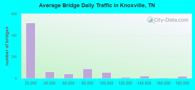
- 26,205,463Total average daily traffic
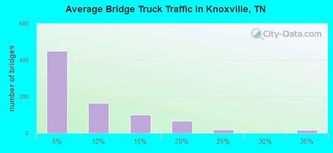
- 3,293,750Total average daily truck traffic
- National Bridge Inventory (NBI) Registered Bridges for Knoxville
- No street view available for this location
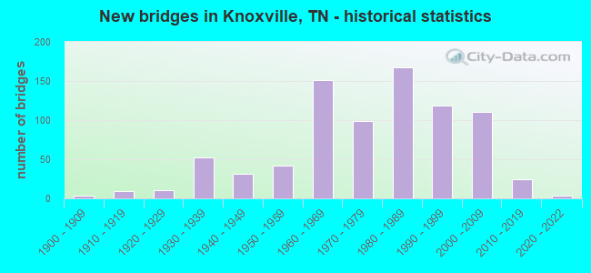
- New bridges - historical statistics
- 1Before 1900
- 31900-1909
- 91910-1919
- 111920-1929
- 521930-1939
- 311940-1949
- 421950-1959
- 1511960-1969
- 991970-1979
- 1681980-1989
- 1191990-1999
- 1112000-2009
- 242010-2019
- 32020-2022
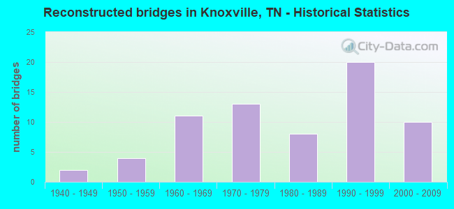
- Reconstructed bridges - Historical Statistics
- 21940-1949
- 41950-1959
- 111960-1969
- 131970-1979
- 81980-1989
- 201990-1999
- 102000-2009
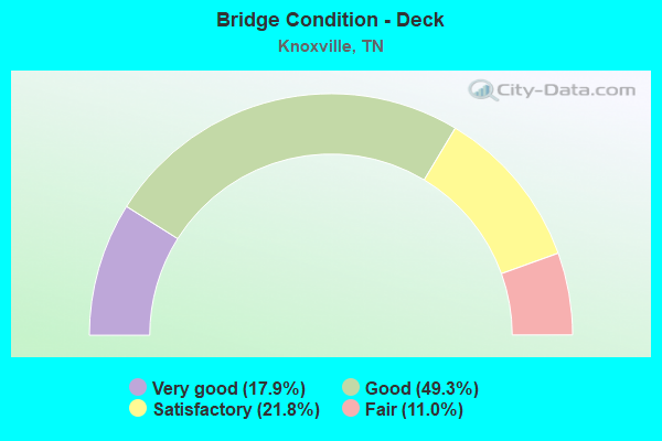
- Bridge Condition - Deck
- 17.9%Very good
- 49.3%Good
- 21.8%Satisfactory
- 11.0%Fair
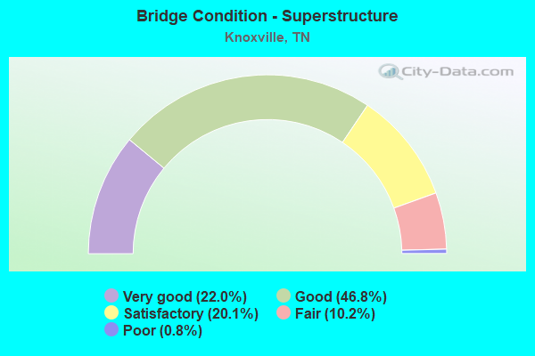
- Bridge Condition - Superstructure
- 22.0%Very good
- 46.8%Good
- 20.1%Satisfactory
- 10.2%Fair
- 0.8%Poor
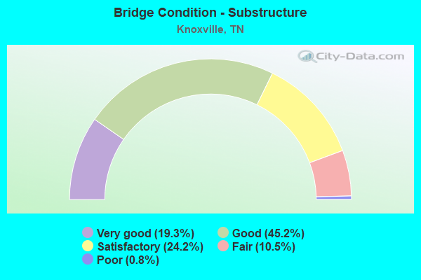
- Bridge Condition - Substructure
- 19.3%Very good
- 45.2%Good
- 24.2%Satisfactory
- 10.5%Fair
- 0.8%Poor
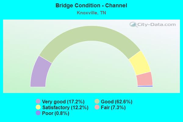
- Bridge Condition - Channel
- 17.2%Very good
- 62.6%Good
- 12.2%Satisfactory
- 7.3%Fair
- 0.8%Poor
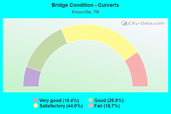
- Bridge Condition - Culverts
- 10.4%Very good
- 26.9%Good
- 44.0%Satisfactory
- 18.7%Fair
Find on map >> Show street view
Structure Number: 470C5900001, Location: E OF I40-SR158 EXIT (Lat: 35.977550, Lng: -83.915217), Route carried "under" structure: City street 590, Year Built: 1910, Structure Length: 0. m, Average Daily Traffic: 6,600 (year 2022), Truck Traffic: 2%, Features Intersected: SOU WALK /EAST FIFTH AVE
Minimum Vertical Clearance: 4.07m (13.35ft), Kilometerpoint: 0.161, Lanes under structure: 2, Material/Design: Concrete, Design/Construction: Slab, Length of Maximum Span: 4.8m (15.7ft)
Find on map >> Show street view
Structure Number: 470C9130001, Location: IN DOWNTOWN KNOXVILLE (Lat: 35.960567, Lng: -83.916950), Route carried "under" structure: City street 913, Year Built: 1975, Structure Length: 0. m, Average Daily Traffic: 7,475 (year 2020), Truck Traffic: 3%, Features Intersected: PED WALK / WEST HILL AVE, Facility Carried by Structure: PED WALKWAY
Minimum Vertical Clearance: 4.53m (14.86ft), Kilometerpoint: 0.328, Lanes under structure: 2, Material/Design: Concrete, Design/Construction: Channel Beam, Length of Maximum Span: 16.5m (54.1ft)
Find on map >> Show street view
Structure Number: 470C9130003, Location: JUST E OF SR 33 & SR 158 (Lat: 35.959900, Lng: -83.918400), Route carried "under" structure: City street 913, Year Built: 1960, Structure Length: 0. m, Average Daily Traffic: 7,475 (year 2020), Truck Traffic: 3%, Features Intersected: PED WALK / WEST HILL AVE, Facility Carried by Structure: PED WALKWAY
Minimum Vertical Clearance: 4.40m (14.44ft), Kilometerpoint: 0.179, Lanes under structure: 2, Material/Design: Concrete, Design/Construction: Tee Beam, Length of Maximum Span: 13.7m (44.9ft)
Find on map >> Show street view
Structure Number: 470C9150001, Location: IN DOWNTOWN KNOXVILLE (Lat: 35.961550, Lng: -83.913133), Route carried "under" structure: City street 915, Year Built: 1998, Structure Length: 0. m, Average Daily Traffic: 5,000 (year 2022), Truck Traffic: 2%, Features Intersected: PED WALK / VOLUNTEER LN, Facility Carried by Structure: PED WALKWAY
Minimum Vertical Clearance: 7.63m (25.03ft), Kilometerpoint: 0.121, Lanes under structure: 2, Material/Design: Concrete continuous, Design/Construction: Stringer/Multi-beam, Length of Maximum Span: 26.5m (86.9ft)
Find on map >> Show street view
Structure Number: 470D3670001, Location: N OF SR331-W OF CORRYTON (Lat: 36.141150, Lng: -83.796083), Route carried "under" structure: County highway 367, Year Built: 1940, Structure Length: 0. m, Average Daily Traffic: 700 (year 2022), Truck Traffic: 2%, Features Intersected: SOU RR / JIM WOLFE RD., Facility Carried by Structure: SOU RWY
Minimum Vertical Clearance: 4.55m (14.93ft), Kilometerpoint: 0.056, Lanes under structure: 2, Material/Design: Wood or Timber, Design/Construction: Stringer/Multi-beam, Length of Maximum Span: 5.8m (19.0ft)
Find on map >> Show street view
Structure Number: 470D8020003, Location: SE OF KNOXVILLE AT RIVER (Lat: 35.960100, Lng: -83.848200), Route carried "under" structure: County highway 5635, Year Built: 1940, Structure Length: 0. m, Average Daily Traffic: 710 (year 2020), Truck Traffic: 3%, Features Intersected: SOU RR / ASBURY RD., Facility Carried by Structure: SOU RWY 730524B
Minimum Vertical Clearance: 6.00m (19.69ft), Kilometerpoint: 1.989, Lanes under structure: 2, Material/Design: Steel continuous, Design/Construction: Stringer/Multi-beam, Length of Maximum Span: 17.8m (58.4ft)
Find on map >> Show street view
Structure Number: 47E00040005, Location: BTWN SR 9 & I75 ON EMORY (Lat: 35.967517, Lng: -84.121167), Route carried "under" structure: State highway 131, Year Built: 1930, Structure Length: 0. m, Average Daily Traffic: 8,847 (year 2020), Truck Traffic: 4%, Features Intersected: CSX RR / B.C. BYINGTON, Facility Carried by Structure: CSX RR 347549T
Minimum Vertical Clearance: 3.26m (10.70ft), Kilometerpoint: 9.817, Lanes under structure: 2, Material/Design: Concrete, Design/Construction: Slab, Length of Maximum Span: 4.2m (13.8ft)
Find on map >> Show street view
Structure Number: 47I00400001, Location: NEAR KNOXVILLE TENN. (Lat: 35.878183, Lng: -84.237450), Route carried "under" structure: Interstate 40, Year Built: 1958, Structure Length: 0. m, Average Daily Traffic: 75,795 (year 2020), Truck Traffic: 23%, Features Intersected: WATT ROAD / I40, Facility Carried by Structure: NFA 1248
Minimum Vertical Clearance: 4.73m (15.52ft), Kilometerpoint: 0.306, Lanes on structure: 2, Lanes under structure: 6, Material/Design: Concrete continuous, Design/Construction: Tee Beam, Length of Maximum Span: 23.2m (76.1ft)
Find on map >> Show street view
Structure Number: 47I00400003, Location: 2 M E OF LOUDON CO LINE (Lat: 35.889100, Lng: -84.212483), Route carried "under" structure: County highway 2420, Year Built: 1967, Structure Length: 0. m, Average Daily Traffic: 1,289 (year 2020), Truck Traffic: 3%, Features Intersected: I40 / EVERETT ROAD, Facility Carried by Structure: I40 (SA 4708)
Minimum Vertical Clearance: 6.43m (21.10ft), Kilometerpoint: 9.962, Lanes on structure: 8, Lanes under structure: 2, Material/Design: Concrete continuous, Design/Construction: Tee Beam, Length of Maximum Span: 20.9m (68.6ft)
Find on map >> Show street view
Structure Number: 47I00400005, Location: IN FARRAGUT (Lat: 35.898467, Lng: -84.175133), Route carried "under" structure: County highway 1277, Year Built: 1968, Structure Length: 0. m, Average Daily Traffic: 28,334 (year 2020), Truck Traffic: 4%, Features Intersected: I40 /CAMPBELL STATION RD, Facility Carried by Structure: I40 RL
Minimum Vertical Clearance: 4.12m (13.52ft), Kilometerpoint: 2.438, Lanes on structure: 6, Lanes under structure: 3, Material/Design: Concrete continuous, Design/Construction: Tee Beam, Length of Maximum Span: 18.3m (60.0ft)
Find on map >> Show street view
Structure Number: 47I00400009, Location: 1.6 MI E JCT I40 & SR162 (Lat: 35.906067, Lng: -84.145450), Route carried "under" structure: Interstate 40, Year Built: 2000, Structure Length: 0. m, Average Daily Traffic: 87,803 (year 2020), Truck Traffic: 19%, Features Intersected: LOVELL RD. / I40, Facility Carried by Structure: FAS 131
Minimum Vertical Clearance: 4.91m (16.11ft), Kilometerpoint: 9.238, Lanes on structure: 8, Lanes under structure: 6, Material/Design: Steel continuous, Design/Construction: Stringer/Multi-beam, Length of Maximum Span: 46.0m (150.9ft)
Find on map >> Show street view
Structure Number: 47I00400013, Location: WEST OF KNOXVILLE (Lat: 35.917917, Lng: -84.090667), Route carried "under" structure: City street 1053, Year Built: 1973, Structure Length: 0. m, Average Daily Traffic: 19,763 (year 2020), Truck Traffic: 4%, Features Intersected: I40 / CEDAR BLUFF RD., Facility Carried by Structure: I40 RL (SA 4711)
Minimum Vertical Clearance: 5.08m (16.67ft), Kilometerpoint: 0.772, Lanes on structure: 9, Lanes under structure: 8, Material/Design: Steel continuous, Design/Construction: Stringer/Multi-beam, Length of Maximum Span: 43.9m (144.0ft)
Find on map >> Show street view
Structure Number: 47I00400017, Location: NEAR KNOXVILLE TENN. (Lat: 35.923517, Lng: -84.065850), Route carried "under" structure: Interstate 40, Year Built: 1998, Structure Length: 0. m, Average Daily Traffic: 168,707 (year 2020), Truck Traffic: 12%, Features Intersected: WALKER SPRGS RD / I40, Facility Carried by Structure: FAU 3778
Minimum Vertical Clearance: 5.01m (16.44ft), Kilometerpoint: 16.673, Lanes on structure: 2, Lanes under structure: 4, Material/Design: Steel continuous, Design/Construction: Stringer/Multi-beam, Length of Maximum Span: 32.3m (106.0ft)
Find on map >> Show street view
Structure Number: 47I00400019, Location: NEAR KNOXVILLE TENN. (Lat: 35.928033, Lng: -84.045800), Route carried "under" structure: Interstate 40, Year Built: 1958, Structure Length: 0. m, Average Daily Traffic: 168,707 (year 2020), Truck Traffic: 12%, Features Intersected: N. WINSTON ROAD / I40, Facility Carried by Structure: NFA A398
Minimum Vertical Clearance: 5.01m (16.44ft), Kilometerpoint: 18.556, Lanes on structure: 2, Lanes under structure: 8, Material/Design: Steel continuous, Design/Construction: Stringer/Multi-beam, Length of Maximum Span: 20.0m (65.6ft)
Find on map >> Show street view
Structure Number: 47I00400023, Location: WEST SIDE OF KNOXVILLE (Lat: 35.929583, Lng: -84.036883), Route carried "under" structure: City street 3777, Year Built: 1968, Structure Length: 0. m, Average Daily Traffic: 13,392 (year 2020), Truck Traffic: 4%, Features Intersected: I40 / BUCKINGHAM RD., Facility Carried by Structure: I40
Minimum Vertical Clearance: 5.06m (16.60ft), Kilometerpoint: 0.161, Lanes on structure: 7, Lanes under structure: 2, Material/Design: Concrete continuous, Design/Construction: Tee Beam, Length of Maximum Span: 15.0m (49.2ft)
Find on map >> Show street view
Structure Number: 47I00400025, Location: NEAR WEST TOWN EXIT (Lat: 35.932833, Lng: -84.022767), Route carried "under" structure: City street 60, Year Built: 1963, Structure Length: 0. m, Average Daily Traffic: 2,000 (year 2022), Truck Traffic: 2%, Features Intersected: I40 / WESLEY RD., Facility Carried by Structure: I40
Minimum Vertical Clearance: 4.68m (15.35ft), Kilometerpoint: 0.100, Lanes on structure: 6, Lanes under structure: 2, Material/Design: Concrete continuous, Design/Construction: Tee Beam, Length of Maximum Span: 12.0m (39.4ft)
Find on map >> Show street view
Structure Number: 47I00400029, Location: JUST EAST OF WEST TOWN (Lat: 35.937883, Lng: -84.009017), Route carried "under" structure: City street 5289, Year Built: 2005, Structure Length: 0. m, Average Daily Traffic: 20,256 (year 2020), Truck Traffic: 4%, Features Intersected: I40 / WEISGARBER RD., Facility Carried by Structure: I40
Minimum Vertical Clearance: 4.50m (14.76ft), Kilometerpoint: 0.853, Lanes on structure: 9, Lanes under structure: 7, Material/Design: Steel continuous, Design/Construction: Stringer/Multi-beam, Length of Maximum Span: 36.2m (118.8ft)
Find on map >> Show street view
Structure Number: 47I00400031, Location: LOCATED AT JCT I40&SR332 (Lat: 35.941833, Lng: -84.001617), Route carried "under" structure: State highway 332, Year Built: 2006, Structure Length: 0. m, Average Daily Traffic: 27,831 (year 2020), Truck Traffic: 4%, Features Intersected: I40 / PAPERMILL RD., Facility Carried by Structure: I40
Minimum Vertical Clearance: 6.51m (21.36ft), Kilometerpoint: 23.175, Lanes on structure: 9, Lanes under structure: 7, Material/Design: Steel continuous, Design/Construction: Stringer/Multi-beam, Length of Maximum Span: 37.0m (121.4ft)
Find on map >> Show street view
Structure Number: 47I00400035, Location: W OF I40-I75 EXCHANGE (Lat: 35.951483, Lng: -83.982283), Route carried "under" structure: City street 5668, Year Built: 1965, Structure Length: 0. m, Average Daily Traffic: 7,242 (year 2020), Truck Traffic: 3%, Features Intersected: I40 / HOLLYWOOD DR., Facility Carried by Structure: I40
Minimum Vertical Clearance: 4.68m (15.35ft), Kilometerpoint: 0.592, Lanes on structure: 6, Lanes under structure: 2, Material/Design: Concrete continuous, Design/Construction: Tee Beam, Length of Maximum Span: 15.0m (49.2ft)
Find on map >> Show street view
Structure Number: 47I00400037, Location: AT I-40 & I-75 JCT. (Lat: 35.956050, Lng: -83.972333), Route carried "under" structure: Interstate 75, Year Built: 1981, Structure Length: 0. m, Average Daily Traffic: 86,616 (year 2020), Truck Traffic: 17%, Features Intersected: I40/I40-EB RMP TO I75 N, Facility Carried by Structure: I40
Minimum Vertical Clearance: 4.83m (15.85ft), Kilometerpoint: 0.000, Lanes on structure: 6, Lanes under structure: 2, Material/Design: Steel continuous, Design/Construction: Stringer/Multi-beam, Length of Maximum Span: 63.4m (208.0ft)
Find on map >> Show street view
Structure Number: 47I00400041, Location: AT I-40 & I-75 JCT. (Lat: 35.957350, Lng: -83.970333), Route carried "under" structure: Interstate 40, Year Built: 1981, Structure Length: 0. m, Average Daily Traffic: 121,876 (year 2020), Truck Traffic: 11%, Features Intersected: I75-SB RMP TO I40 EB/I40, Facility Carried by Structure: I75 RMP D-D
Minimum Vertical Clearance: 4.78m (15.68ft), Kilometerpoint: 26.232, Lanes on structure: 2, Lanes under structure: 6, Material/Design: Steel continuous, Design/Construction: Stringer/Multi-beam, Length of Maximum Span: 62.2m (204.1ft)
Find on map >> Show street view
Structure Number: 47I00400043, Location: NEAR KNOXVILLE TENN. (Lat: 35.959033, Lng: -83.965550), Route carried "under" structure: Interstate 40, Year Built: 1962, Structure Length: 0. m, Average Daily Traffic: 121,876 (year 2020), Truck Traffic: 13%, Features Intersected: LIBERTY ST. / I40, Facility Carried by Structure: FAU 5649
Minimum Vertical Clearance: 5.26m (17.26ft), Kilometerpoint: 26.635, Lanes on structure: 4, Lanes under structure: 6, Material/Design: Steel continuous, Design/Construction: Stringer/Multi-beam, Length of Maximum Span: 41.6m (136.5ft)
Find on map >> Show street view
Structure Number: 47I00400045, Location: EAST OF I-75 JCT. (Lat: 35.961667, Lng: -83.951667), Route carried "under" structure: City street 169, Year Built: 1965, Structure Length: 0. m, Average Daily Traffic: 15,323 (year 2020), Truck Traffic: 4%, Features Intersected: I40/MIDDLEBROOK PK. & RR, Facility Carried by Structure: I40
Minimum Vertical Clearance: 7.63m (25.03ft), Kilometerpoint: 17.123, Lanes on structure: 6, Lanes under structure: 4, Material/Design: Steel continuous, Design/Construction: Stringer/Multi-beam, Length of Maximum Span: 40.5m (132.9ft)
Find on map >> Show street view
Structure Number: 47I00400047, Location: DOWNTOWN KNOXVILLE (Lat: 35.963450, Lng: -83.947233), Route carried "under" structure: Ramp Interstate 40, Year Built: 2000, Structure Length: 0. m, Average Daily Traffic: 121,876 (year 2020), Truck Traffic: 13%, Features Intersected: I40&I40 EB RMP/I40-RMP
Minimum Vertical Clearance: 5.19m (17.03ft), Kilometerpoint: 28.421, Lanes on structure: 8, Lanes under structure: 1, Material/Design: Steel continuous, Design/Construction: Stringer/Multi-beam, Length of Maximum Span: 32.9m (107.9ft)
Find on map >> Show street view
Structure Number: 47I00400047, Location: IN KNOXVILLE (Lat: 35.963367, Lng: -83.946783), Route carried "under" structure: Ramp Interstate 40, Year Built: 2000, Structure Length: 0. m, Average Daily Traffic: 122,095 (year 2020), Truck Traffic: 13%, Features Intersected: I40 RAMP
Minimum Vertical Clearance: 5.62m (18.44ft), Kilometerpoint: 28.453, Lanes on structure: 8, Lanes under structure: 2, Material/Design: Steel continuous, Design/Construction: Stringer/Multi-beam, Length of Maximum Span: 32.9m (107.9ft)
Find on map >> Show street view
Structure Number: 47I00400049, Location: DOWNTOWN KNOXVILLE (Lat: 35.963133, Lng: -83.945850), Route carried "under" structure: City street 169, Year Built: 1965, Structure Length: 0. m, Average Daily Traffic: 15,414 (year 2020), Truck Traffic: 4%, Features Intersected: I40 / UNIVERSITY AVE., Facility Carried by Structure: I40
Minimum Vertical Clearance: 7.63m (25.03ft), Kilometerpoint: 17.751, Lanes on structure: 8, Lanes under structure: 4, Material/Design: Steel continuous, Design/Construction: Stringer/Multi-beam, Length of Maximum Span: 20.7m (67.9ft)
Find on map >> Show street view
Structure Number: 47I00400051, Location: AT I40-ALCO EXCHANGE (Lat: 35.962900, Lng: -83.942600), Route carried "under" structure: City street 499, Year Built: 1965, Structure Length: 0. m, Average Daily Traffic: 2,948 (year 2020), Truck Traffic: 4%, Features Intersected: I40 / 21ST. STREET, Facility Carried by Structure: I40
Minimum Vertical Clearance: 5.54m (18.18ft), Kilometerpoint: 0.386, Lanes on structure: 7, Lanes under structure: 3, Material/Design: Steel continuous, Design/Construction: Stringer/Multi-beam, Length of Maximum Span: 19.4m (63.6ft)
Find on map >> Show street view
Structure Number: 47I00400053, Location: JUST W OF SR62-DOWNTOWN (Lat: 35.963883, Lng: -83.936350), Route carried "under" structure: City street 3780, Year Built: 1954, Structure Length: 0. m, Average Daily Traffic: 13,818 (year 2020), Truck Traffic: 4%, Features Intersected: I40-RL / 17TH. STREET, Facility Carried by Structure: I40
Minimum Vertical Clearance: 6.13m (20.11ft), Kilometerpoint: 0.280, Lanes on structure: 5, Lanes under structure: 4, Material/Design: Concrete, Design/Construction: Tee Beam, Length of Maximum Span: 13.1m (43.0ft)
Find on map >> Show street view
Structure Number: 47I00400054, Location: JUST W OF SR62/I40 (Lat: 35.964400, Lng: -83.936650), Route carried "under" structure: County highway 3780, Year Built: 1965, Structure Length: 0. m, Average Daily Traffic: 13,818 (year 2020), Truck Traffic: 4%, Features Intersected: I40-LL / 17TH. STREET, Facility Carried by Structure: I40 LL
Minimum Vertical Clearance: 4.96m (16.27ft), Kilometerpoint: 0.241, Lanes on structure: 6, Lanes under structure: 4, Material/Design: Concrete, Design/Construction: Tee Beam, Length of Maximum Span: 13.1m (43.0ft)
Find on map >> Show street view
Structure Number: 47I00400055, Location: NEAR KNOXVILLE TENN. (Lat: 35.965483, Lng: -83.932967), Route carried "under" structure: Interstate 40, Year Built: 1981, Structure Length: 0. m, Average Daily Traffic: 122,095 (year 2020), Truck Traffic: 12%, Features Intersected: WESTERN AVE. / I40, Facility Carried by Structure: FAU 62
Minimum Vertical Clearance: 5.06m (16.60ft), Kilometerpoint: 29.837, Lanes on structure: 5, Lanes under structure: 11, Material/Design: Steel continuous, Design/Construction: Stringer/Multi-beam, Length of Maximum Span: 45.1m (148.0ft)
Find on map >> Show street view
Structure Number: 47I00400057, Location: AT I40-I275 EXCHANGE (Lat: 35.969583, Lng: -83.927800), Route carried "under" structure: City street 220, Year Built: 1982, Structure Length: 0. m, Average Daily Traffic: 1,426 (year 2020), Truck Traffic: 3%, Features Intersected: I40WB-RMP/BLACKSTOCK-RR, Facility Carried by Structure: I40 RMP
Minimum Vertical Clearance: 4.78m (15.68ft), Kilometerpoint: 0.813, Lanes on structure: 1, Lanes under structure: 3, Material/Design: Steel continuous, Design/Construction: Stringer/Multi-beam, Length of Maximum Span: 36.6m (120.1ft)
Find on map >> Show street view
Structure Number: 47I00400059, Location: IN KNOXVILLE (Lat: 35.968267, Lng: -83.929700), Route carried "under" structure: Interstate 40, Year Built: 1982, Structure Length: 0. m, Average Daily Traffic: 122,095 (year 2020), Truck Traffic: 12%, Features Intersected: I40-EB RMP TO I275 / I40, Facility Carried by Structure: I275 RL ONLY
Minimum Vertical Clearance: 5.18m (16.99ft), Kilometerpoint: 30.191, Lanes on structure: 3, Lanes under structure: 6, Material/Design: Steel continuous, Design/Construction: Stringer/Multi-beam, Length of Maximum Span: 71.3m (233.9ft)
Find on map >> Show street view
Structure Number: 47I00400061, Location: WILLOW AVENUE (Lat: 35.969883, Lng: -83.924933), Route carried "under" structure: County highway 969, Year Built: 2006, Structure Length: 0. m, Average Daily Traffic: 8,100 (year 2022), Truck Traffic: 2%, Features Intersected: I40 VIADUCT / COOPER ST., Facility Carried by Structure: I40
Minimum Vertical Clearance: 7.63m (25.03ft), Kilometerpoint: 0.708, Lanes on structure: 9, Lanes under structure: 2, Material/Design: Steel continuous, Design/Construction: Stringer/Multi-beam, Length of Maximum Span: 35.1m (115.2ft)
Find on map >> Show street view
Structure Number: 47I00400061, Location: WILLOW AVENUE (Lat: 35.970733, Lng: -83.922783), Route carried "under" structure: County highway 3775, Year Built: 2006, Structure Length: 0. m, Average Daily Traffic: 1,986 (year 2020), Truck Traffic: 4%, Features Intersected: I40 VIADUCT / GAY STREET, Facility Carried by Structure: I40
Minimum Vertical Clearance: 4.53m (14.86ft), Kilometerpoint: 2.205, Lanes on structure: 9, Lanes under structure: 3, Material/Design: Steel continuous, Design/Construction: Stringer/Multi-beam, Length of Maximum Span: 35.1m (115.2ft)
Find on map >> Show street view
Structure Number: 47I00400061, Location: DOWNTOWN KNOXVILLE (Lat: 35.975800, Lng: -83.918317), Route carried "under" structure: US 11, Year Built: 2006, Structure Length: 0. m, Average Daily Traffic: 32,431 (year 2020), Truck Traffic: 9%, Features Intersected: I40 VIADUCT / BROADWAY, Facility Carried by Structure: FAU 3788
Minimum Vertical Clearance: 5.97m (19.59ft), Kilometerpoint: 12.633, Lanes on structure: 9, Lanes under structure: 4, Material/Design: Steel continuous, Design/Construction: Stringer/Multi-beam, Length of Maximum Span: 35.1m (115.2ft)
Find on map >> Show street view
Structure Number: 47I00400061, Location: JACKSON AVENUE (Lat: 35.972817, Lng: -83.920350), Route carried "under" structure: County highway 5657, Year Built: 2006, Structure Length: 0. m, Average Daily Traffic: 2,740 (year 2020), Truck Traffic: 4%, Features Intersected: I40 VIADUCT/N. CENTRAL S, Facility Carried by Structure: I40
Minimum Vertical Clearance: 7.24m (23.75ft), Kilometerpoint: 0.418, Lanes on structure: 9, Lanes under structure: 3, Material/Design: Steel continuous, Design/Construction: Stringer/Multi-beam, Length of Maximum Span: 35.1m (115.2ft)
Find on map >> Show street view
Structure Number: 47I00400061, Location: WILLOW AVENUE (Lat: 35.969317, Lng: -83.927500), Route carried "under" structure: County highway 5927, Year Built: 2006, Structure Length: 0. m, Average Daily Traffic: 1,426 (year 2020), Truck Traffic: 3%, Features Intersected: I40 VIADUCT / BLACKSTOCK, Facility Carried by Structure: I40
Minimum Vertical Clearance: 5.49m (18.01ft), Kilometerpoint: 0.764, Lanes on structure: 9, Lanes under structure: 2, Material/Design: Steel continuous, Design/Construction: Stringer/Multi-beam, Length of Maximum Span: 35.1m (115.2ft)
Find on map >> Show street view
Structure Number: 47I00400061, Location: WILLOW AVENUE (Lat: 35.968900, Lng: -83.927517), Route carried "under" structure: County highway 5927, Year Built: 2006, Structure Length: 0. m, Average Daily Traffic: 1,426 (year 2020), Truck Traffic: 3%, Features Intersected: I40 VIADUCT / BLACKSTOCK, Facility Carried by Structure: I40
Minimum Vertical Clearance: 4.86m (15.94ft), Kilometerpoint: 0.732, Lanes on structure: 9, Lanes under structure: 2, Material/Design: Steel continuous, Design/Construction: Stringer/Multi-beam, Length of Maximum Span: 35.1m (115.2ft)
Find on map >> Show street view
Structure Number: 47I00400061, Location: WILLOW AVENUE (Lat: 35.971600, Lng: -83.921533), Route carried "under" structure: County highway 593, Year Built: 2006, Structure Length: 0. m, Average Daily Traffic: 8,100 (year 2022), Truck Traffic: 2%, Features Intersected: I40 VIADUCT / WILLIAMS S, Facility Carried by Structure: I40
Minimum Vertical Clearance: 6.30m (20.67ft), Kilometerpoint: 0.193, Lanes on structure: 9, Lanes under structure: 2, Material/Design: Steel continuous, Design/Construction: Stringer/Multi-beam, Length of Maximum Span: 35.1m (115.2ft)
Find on map >> Show street view
Structure Number: 47I00400063, Location: DOWNTOWN KNOXVILLE (Lat: 35.975867, Lng: -83.918450), Route carried "under" structure: City street 6025, Year Built: 2007, Structure Length: 0. m, Average Daily Traffic: 4,955 (year 2020), Truck Traffic: 9%, Features Intersected: I40-RL / E. FIFTH AVE., Facility Carried by Structure: I40
Minimum Vertical Clearance: 7.63m (25.03ft), Kilometerpoint: 0.668, Lanes on structure: 3, Lanes under structure: 2, Material/Design: Steel continuous, Design/Construction: Stringer/Multi-beam, Length of Maximum Span: 51.4m (168.6ft)
Find on map >> Show street view
Structure Number: 47I00400063, Location: DOWNTOWN KNOXVILLE (Lat: 35.975800, Lng: -83.918317), Route carried "under" structure: State highway 158, Year Built: 2007, Structure Length: 0. m, Average Daily Traffic: 33,144 (year 2020), Truck Traffic: 13%, Features Intersected: I40-RL/SR158 RP TO I40 W, Facility Carried by Structure: I40
Minimum Vertical Clearance: 5.34m (17.52ft), Kilometerpoint: 1.674, Lanes on structure: 3, Lanes under structure: 2, Material/Design: Steel continuous, Design/Construction: Stringer/Multi-beam, Length of Maximum Span: 51.4m (168.6ft)
Find on map >> Show street view
Structure Number: 47I00400064, Location: DOWNTOWN KNOXVILLE (Lat: 35.974967, Lng: -83.918683), Route carried "under" structure: City street 6025, Year Built: 2007, Structure Length: 0. m, Average Daily Traffic: 4,955 (year 2020), Truck Traffic: 9%, Features Intersected: I40-LL / E. FIFTH AVE., Facility Carried by Structure: I40
Minimum Vertical Clearance: 6.41m (21.03ft), Kilometerpoint: 0.668, Lanes on structure: 3, Lanes under structure: 4, Material/Design: Steel continuous, Design/Construction: Stringer/Multi-beam, Length of Maximum Span: 51.4m (168.6ft)
Find on map >> Show street view
Structure Number: 47I00400067, Location: E OF SR158 EXCHANGE (Lat: 35.984633, Lng: -83.906733), Route carried "under" structure: City street 581, Year Built: 2007, Structure Length: 0. m, Average Daily Traffic: 400 (year 2022), Truck Traffic: 2%, Features Intersected: I40 / GILL AVE., Facility Carried by Structure: I40
Minimum Vertical Clearance: 5.80m (19.03ft), Kilometerpoint: 0.444, Lanes on structure: 8, Lanes under structure: 2, Material/Design: Prestressed concrete, Design/Construction: Stringer/Multi-beam, Length of Maximum Span: 37.1m (121.7ft)
Find on map >> Show street view
Structure Number: 47I00400068, Location: E OF SR158 EXCHANGE (Lat: 35.984633, Lng: -83.906733), Route carried "under" structure: City street 581, Year Built: 2007, Structure Length: 0. m, Average Daily Traffic: 400 (year 2022), Truck Traffic: 2%, Features Intersected: I40-WB-RMP / GILL AVE., Facility Carried by Structure: I40
Minimum Vertical Clearance: 5.64m (18.50ft), Kilometerpoint: 0.402, Lanes on structure: 2, Lanes under structure: 2, Material/Design: Prestressed concrete, Design/Construction: Stringer/Multi-beam, Length of Maximum Span: 35.3m (115.8ft)
Find on map >> Show street view
Structure Number: 47I00400069, Location: EAST OF I-40 VIADUCT (Lat: 35.981667, Lng: -83.918333), Route carried "under" structure: Interstate 40, Year Built: 1965, Structure Length: 0. m, Average Daily Traffic: 80,617 (year 2020), Truck Traffic: 22%, Features Intersected: HALL OF FAME DR / I40, Facility Carried by Structure: NFA 5666
Minimum Vertical Clearance: 5.26m (17.26ft), Kilometerpoint: 32.436, Lanes on structure: 2, Lanes under structure: 4, Material/Design: Steel continuous, Design/Construction: Girder and Floorbeam System, Length of Maximum Span: 32.7m (107.3ft)
Find on map >> Show street view
Structure Number: 47I00400071, Location: 0.7 MI W JCT I40 & SR 62 (Lat: 35.962267, Lng: -83.941533), Route carried "under" structure: Ramp Interstate 40, Year Built: 1981, Structure Length: 0. m, Average Daily Traffic: 122,095 (year 2020), Truck Traffic: 12%, Features Intersected: SR115-EB RMP/I40&21ST., Facility Carried by Structure: SR 115 RAMP
Minimum Vertical Clearance: 5.06m (16.60ft), Kilometerpoint: 28.646, Lanes on structure: 2, Lanes under structure: 1, Material/Design: Steel, Design/Construction: Frame, Length of Maximum Span: 32.0m (105.0ft)
Find on map >> Show street view
Structure Number: 47I00400075, Location: E OF I40-SR158 EXCHANGE (Lat: 35.984783, Lng: -83.914567), Route carried "under" structure: City street 480, Year Built: 1991, Structure Length: 0. m, Average Daily Traffic: 1,000 (year 2022), Truck Traffic: 2%, Features Intersected: I40 / NORTH 6TH ST., Facility Carried by Structure: I40
Minimum Vertical Clearance: 7.63m (25.03ft), Kilometerpoint: 0.884, Lanes on structure: 9, Lanes under structure: 2, Material/Design: Steel continuous, Design/Construction: Stringer/Multi-beam, Length of Maximum Span: 24.3m (79.7ft)
Find on map >> Show street view
Structure Number: 47I00400077, Location: E OF I40-SR158 EXCHANGE (Lat: 35.984900, Lng: -83.912700), Route carried "under" structure: City street 565, Year Built: 1967, Structure Length: 0. m, Average Daily Traffic: 800 (year 2022), Truck Traffic: 2%, Features Intersected: I40 /SOU RR& MITCHELL ST, Facility Carried by Structure: I40 RL
Minimum Vertical Clearance: 4.83m (15.85ft), Kilometerpoint: 3.898, Lanes on structure: 11, Lanes under structure: 2, Material/Design: Steel continuous, Design/Construction: Stringer/Multi-beam, Length of Maximum Span: 40.3m (132.2ft)
Find on map >> Show street view
Structure Number: 47I00400079, Location: E OF SR158 EXCHANGE (Lat: 35.984633, Lng: -83.906733), Route carried "under" structure: City street 571, Year Built: 1991, Structure Length: 0. m, Average Daily Traffic: 400 (year 2022), Truck Traffic: 2%, Features Intersected: I-40 / BORUFF ST., Facility Carried by Structure: I40 RL
Minimum Vertical Clearance: 4.67m (15.32ft), Kilometerpoint: 0.451, Lanes on structure: 10, Lanes under structure: 2, Material/Design: Concrete continuous, Design/Construction: Tee Beam, Length of Maximum Span: 25.6m (84.0ft)
Find on map >> Show street view
Structure Number: 47I00400081, Location: 2 MI. W. OF SR 1 (Lat: 35.991650, Lng: -83.900617), Route carried "under" structure: City street 3772, Year Built: 1967, Structure Length: 0. m, Average Daily Traffic: 15,047 (year 2020), Truck Traffic: 3%, Features Intersected: I40 / CHERRY STREET, Facility Carried by Structure: I40
Minimum Vertical Clearance: 4.68m (15.35ft), Kilometerpoint: 0.789, Lanes on structure: 8, Lanes under structure: 4, Material/Design: Concrete continuous, Design/Construction: Tee Beam, Length of Maximum Span: 15.6m (51.2ft)
Find on map >> Show street view
Structure Number: 47I00400083, Location: JUST W OF US11W EXIT (Lat: 36.002633, Lng: -83.884333), Route carried "under" structure: City street 119, Year Built: 1968, Structure Length: 0. m, Average Daily Traffic: 2,427 (year 2020), Truck Traffic: 3%, Features Intersected: I40 / PROSSER ROAD, Facility Carried by Structure: I40
Minimum Vertical Clearance: 4.96m (16.27ft), Kilometerpoint: 0.756, Lanes on structure: 6, Lanes under structure: 4, Material/Design: Concrete continuous, Design/Construction: Tee Beam, Length of Maximum Span: 23.6m (77.4ft)
Find on map >> Show street view
Structure Number: 47I00400085, Location: JUST W. OF I-640 JCT. (Lat: 36.007233, Lng: -83.873900), Route carried "under" structure: US 11, Year Built: 1968, Structure Length: 0. m, Average Daily Traffic: 18,313 (year 2020), Truck Traffic: 9%, Features Intersected: I40 / RUTLEDGE PIKE, Facility Carried by Structure: I40
Minimum Vertical Clearance: 5.29m (17.36ft), Kilometerpoint: 39.786, Lanes on structure: 7, Lanes under structure: 4, Material/Design: Steel continuous, Design/Construction: Stringer/Multi-beam, Length of Maximum Span: 21.9m (71.9ft)
Find on map >> Show street view
Structure Number: 47I00400087, Location: JUST W. OF I-640 JCT. (Lat: 36.010300, Lng: -83.867350), Route carried "under" structure: Interstate 40, Year Built: 1982, Structure Length: 0. m, Average Daily Traffic: 68,433 (year 2020), Truck Traffic: 24%, Features Intersected: SPRING HILL ROAD / I40, Facility Carried by Structure: NFA C453
Minimum Vertical Clearance: 5.14m (16.86ft), Kilometerpoint: 37.932, Lanes on structure: 2, Lanes under structure: 8, Material/Design: Prestressed concrete continuous, Design/Construction: Box Beam or Girders - Single/Spread, Length of Maximum Span: 38.1m (125.0ft)
Find on map >> Show street view
Structure Number: 47I00400089, Location: JUST E OF I40-I640 EXCH. (Lat: 36.012800, Lng: -83.854483), Route carried "under" structure: City street 5658, Year Built: 1982, Structure Length: 0. m, Average Daily Traffic: 5,380 (year 2020), Truck Traffic: 3%, Features Intersected: I40 / CHILHOWEE ROAD, Facility Carried by Structure: I40
Minimum Vertical Clearance: 5.52m (18.11ft), Kilometerpoint: 0.700, Lanes on structure: 9, Lanes under structure: 2, Material/Design: Prestressed concrete, Design/Construction: Box Beam or Girders - Single/Spread, Length of Maximum Span: 28.0m (91.9ft)
Find on map >> Show street view
Structure Number: 47I00400093, Location: NEAR KNOXVILLE TENN. (Lat: 36.010317, Lng: -83.841650), Route carried "under" structure: US 25, Year Built: 1965, Structure Length: 0. m, Average Daily Traffic: 32,168 (year 2020), Truck Traffic: 9%, Features Intersected: I40 / ASHEVILLE HWY., Facility Carried by Structure: I40
Minimum Vertical Clearance: 4.35m (14.27ft), Kilometerpoint: 11.652, Lanes on structure: 6, Lanes under structure: 4, Material/Design: Prestressed concrete continuous, Design/Construction: Stringer/Multi-beam, Length of Maximum Span: 15.8m (51.8ft)
Find on map >> Show street view
Structure Number: 47I00400095, Location: JUST E OF US11E EXCHANGE (Lat: 36.008617, Lng: -83.838333), Route carried "under" structure: City street 123, Year Built: 1968, Structure Length: 0. m, Average Daily Traffic: 200 (year 2022), Truck Traffic: 2%, Features Intersected: I40 / HOLSTON DRIVE, Facility Carried by Structure: I40
Minimum Vertical Clearance: 4.81m (15.78ft), Kilometerpoint: 3.600, Lanes on structure: 6, Lanes under structure: 2, Material/Design: Prestressed concrete continuous, Design/Construction: Stringer/Multi-beam, Length of Maximum Span: 14.6m (47.9ft)
Find on map >> Show street view
Structure Number: 47I00400099, Location: AT HOLSTON RIVER (Lat: 36.008950, Lng: -83.824833), Route carried "under" structure: State highway 168, Year Built: 1975, Structure Length: 0. m, Average Daily Traffic: 12,859 (year 2020), Truck Traffic: 4%, Features Intersected: I40 / HOLSTON R. &SR 168, Facility Carried by Structure: I40
Minimum Vertical Clearance: 4.81m (15.78ft), Kilometerpoint: 24.720, Lanes on structure: 6, Lanes under structure: 2, Material/Design: Steel continuous, Design/Construction: Stringer/Multi-beam, Length of Maximum Span: 73.2m (240.2ft)
Find on map >> Show street view
Structure Number: 47I00400101, Location: NEAR THE SEVIER CO LINE (Lat: 36.006417, Lng: -83.805733), Route carried "under" structure: Interstate 40, Year Built: 1975, Structure Length: 0. m, Average Daily Traffic: 74,140 (year 2020), Truck Traffic: 30%, Features Intersected: OGLESBY ROAD / I40, Facility Carried by Structure: NFA D668
Minimum Vertical Clearance: 5.01m (16.44ft), Kilometerpoint: 43.807, Lanes on structure: 2, Lanes under structure: 6, Material/Design: Concrete continuous, Design/Construction: Box Beam or Girders - Multiple, Length of Maximum Span: 36.4m (119.4ft)
Find on map >> Show street view
Structure Number: 47I00400103, Location: NEAR THE SEVIER CO LINE (Lat: 36.003783, Lng: -83.788233), Route carried "under" structure: Interstate 40, Year Built: 1971, Structure Length: 0. m, Average Daily Traffic: 74,140 (year 2020), Truck Traffic: 30%, Features Intersected: UNION SCHOOL ROAD / I40, Facility Carried by Structure: NFA D670
Minimum Vertical Clearance: 4.96m (16.27ft), Kilometerpoint: 45.416, Lanes on structure: 2, Lanes under structure: 6, Material/Design: Concrete continuous, Design/Construction: Box Beam or Girders - Multiple, Length of Maximum Span: 38.1m (125.0ft)
Find on map >> Show street view
Structure Number: 47I00400105, Location: IN KNOX CO (Lat: 36.002733, Lng: -83.775383), Route carried "under" structure: County highway 1124, Year Built: 1975, Structure Length: 0. m, Average Daily Traffic: 8,137 (year 2020), Truck Traffic: 4%, Features Intersected: I40-RL/STRAWBERRY PLAIN, Facility Carried by Structure: I40 RL
Minimum Vertical Clearance: 5.01m (16.44ft), Kilometerpoint: 13.889, Lanes on structure: 3, Lanes under structure: 4, Material/Design: Concrete continuous, Design/Construction: Box Beam or Girders - Single/Spread, Length of Maximum Span: 29.7m (97.4ft)
Find on map >> Show street view
Structure Number: 47I00400106, Location: IN KNOX CO (Lat: 36.003017, Lng: -83.775150), Route carried "under" structure: County highway 1124, Year Built: 1975, Structure Length: 0. m, Average Daily Traffic: 6,889 (year 2020), Truck Traffic: 3%, Features Intersected: I40-LL/STRAWBERRY PLAIN, Facility Carried by Structure: I40 LL
Minimum Vertical Clearance: 5.00m (16.40ft), Kilometerpoint: 13.921, Lanes on structure: 3, Lanes under structure: 4, Material/Design: Concrete continuous, Design/Construction: Box Beam or Girders - Single/Spread, Length of Maximum Span: 29.9m (98.1ft)
Find on map >> Show street view
Structure Number: 47I00400107, Location: 4.3 MI E JCT I40&SR168 (Lat: 36.003633, Lng: -83.766683), Route carried "under" structure: County highway 5861, Year Built: 1975, Structure Length: 0. m, Average Daily Traffic: 2,251 (year 2020), Truck Traffic: 4%, Features Intersected: I40-RL/HUCKLEBERY SPG RD, Facility Carried by Structure: I40 RL
Minimum Vertical Clearance: 6.33m (20.77ft), Kilometerpoint: 0.531, Lanes on structure: 3, Lanes under structure: 2, Material/Design: Concrete continuous, Design/Construction: Tee Beam, Length of Maximum Span: 19.5m (64.0ft)
Find on map >> Show street view
Structure Number: 47I00400108, Location: 4.3 MI E JCT I40&SR168 (Lat: 36.004117, Lng: -83.766883), Route carried "under" structure: County highway 5861, Year Built: 1975, Structure Length: 0. m, Average Daily Traffic: 2,251 (year 2020), Truck Traffic: 4%, Features Intersected: I40-LL/HUCKLEBERY SPG RD, Facility Carried by Structure: I40 LL
Minimum Vertical Clearance: 4.81m (15.78ft), Kilometerpoint: 0.491, Lanes on structure: 3, Lanes under structure: 2, Material/Design: Concrete continuous, Design/Construction: Tee Beam, Length of Maximum Span: 19.5m (64.0ft)
Find on map >> Show street view
Structure Number: 47I00400109, Location: NEAR THE SEVIER CO LINE (Lat: 36.005167, Lng: -83.750300), Route carried "under" structure: Interstate 40, Year Built: 1975, Structure Length: 0. m, Average Daily Traffic: 72,058 (year 2020), Truck Traffic: 33%, Features Intersected: MCMILLAND ROAD / I40, Facility Carried by Structure: NFA D680
Minimum Vertical Clearance: 5.08m (16.67ft), Kilometerpoint: 48.876, Lanes on structure: 2, Lanes under structure: 6, Material/Design: Concrete continuous, Design/Construction: Box Beam or Girders - Multiple, Length of Maximum Span: 39.0m (128.0ft)
Find on map >> Show street view
Structure Number: 47I00400111, Location: JUST W OF THORNGROVE EXIT (Lat: 35.997583, Lng: -83.722400), Route carried "under" structure: County highway 690, Year Built: 1975, Structure Length: 0. m, Average Daily Traffic: 200 (year 2022), Truck Traffic: 2%, Features Intersected: I40-EB / COOPER ROAD, Facility Carried by Structure: I40 RL
Minimum Vertical Clearance: 4.27m (14.01ft), Kilometerpoint: 2.900, Lanes on structure: 3, Lanes under structure: 2, Material/Design: Concrete continuous, Design/Construction: Tee Beam, Length of Maximum Span: 23.2m (76.1ft)
Find on map >> Show street view
Structure Number: 47I00400112, Location: JUST W OF THORNGROVE EXIT (Lat: 35.997933, Lng: -83.722017), Route carried "under" structure: County highway 690, Year Built: 1975, Structure Length: 0. m, Average Daily Traffic: 200 (year 2022), Truck Traffic: 2%, Features Intersected: I40-WB / COOPER ROAD, Facility Carried by Structure: I40 LL
Minimum Vertical Clearance: 4.27m (14.01ft), Kilometerpoint: 2.858, Lanes on structure: 3, Lanes under structure: 2, Material/Design: Concrete continuous, Design/Construction: Tee Beam, Length of Maximum Span: 23.2m (76.1ft)
Find on map >> Show street view
Structure Number: 47I00400113, Location: NEAR KNOXVILLE TENN. (Lat: 35.996783, Lng: -83.710233), Route carried "under" structure: Interstate 40, Year Built: 1971, Structure Length: 0. m, Average Daily Traffic: 72,058 (year 2020), Truck Traffic: 33%, Features Intersected: THORNGROVE ROAD / I40, Facility Carried by Structure: NFA 1260
Minimum Vertical Clearance: 5.06m (16.60ft), Kilometerpoint: 52.626, Lanes on structure: 2, Lanes under structure: 6, Material/Design: Concrete continuous, Design/Construction: Box Beam or Girders - Multiple, Length of Maximum Span: 40.2m (131.9ft)
Find on map >> Show street view
Structure Number: 47I00400115, Location: E OF THORNGROVE PK EXIT (Lat: 35.996467, Lng: -83.699550), Route carried "under" structure: County highway 2399, Year Built: 1975, Structure Length: 0. m, Average Daily Traffic: 2,184 (year 2020), Truck Traffic: 4%, Features Intersected: I40-RL / MIDWAY ROAD, Facility Carried by Structure: I40 RL (SA 4735)
Minimum Vertical Clearance: 4.88m (16.01ft), Kilometerpoint: 4.361, Lanes on structure: 3, Lanes under structure: 2, Material/Design: Concrete continuous, Design/Construction: Tee Beam, Length of Maximum Span: 26.5m (86.9ft)
Find on map >> Show street view
Structure Number: 47I00400116, Location: E OF THORNGROVRE PK EXIT (Lat: 35.996733, Lng: -83.699767), Route carried "under" structure: County highway 2399, Year Built: 1975, Structure Length: 0. m, Average Daily Traffic: 2,184 (year 2020), Truck Traffic: 4%, Features Intersected: I40-LL / MIDWAY ROAD, Facility Carried by Structure: I40 LL (SA 4735)
Minimum Vertical Clearance: 4.91m (16.11ft), Kilometerpoint: 4.377, Lanes on structure: 3, Lanes under structure: 2, Material/Design: Concrete continuous, Design/Construction: Tee Beam, Length of Maximum Span: 26.5m (86.9ft)
Find on map >> Show street view
Structure Number: 47I00400119, Location: 1.8 M W OF SEVIER CO LINE (Lat: 35.995067, Lng: -83.680883), Route carried "under" structure: County highway 696, Year Built: 1975, Structure Length: 0. m, Average Daily Traffic: 200 (year 2022), Truck Traffic: 2%, Features Intersected: I40-EB / SMITH SCHOOL RD, Facility Carried by Structure: I40 RL
Minimum Vertical Clearance: 6.18m (20.28ft), Kilometerpoint: 0.998, Lanes on structure: 3, Lanes under structure: 2, Material/Design: Concrete continuous, Design/Construction: Tee Beam, Length of Maximum Span: 21.8m (71.5ft)
Find on map >> Show street view
Structure Number: 47I0040012, Location: 1.8 M W OF SEVIER CO LINE (Lat: 35.995650, Lng: -83.680983), Route carried "under" structure: County highway 696, Year Built: 1975, Structure Length: 0. m, Average Daily Traffic: 200 (year 2022), Truck Traffic: 2%, Features Intersected: I40-WB / SMITH SCHOOL RD, Facility Carried by Structure: I40 LL
Minimum Vertical Clearance: 7.63m (25.03ft), Kilometerpoint: 0.937, Lanes on structure: 3, Lanes under structure: 2, Material/Design: Concrete continuous, Design/Construction: Tee Beam, Length of Maximum Span: 21.9m (71.9ft)
Find on map >> Show street view
Structure Number: 47I00400123, Location: I-40 & I-640 JCT. (Lat: 36.013650, Lng: -83.859567), Route carried "under" structure: Ramp Interstate 640, Year Built: 1982, Structure Length: 0. m, Average Daily Traffic: 66,065 (year 2020), Truck Traffic: 14%, Features Intersected: I40 / I640 RMP TO I40-EB, Facility Carried by Structure: I40
Minimum Vertical Clearance: 5.36m (17.59ft), Kilometerpoint: 11.298, Lanes on structure: 6, Lanes under structure: 2, Material/Design: Steel continuous, Design/Construction: Stringer/Multi-beam, Length of Maximum Span: 51.2m (168.0ft)
Find on map >> Show street view
Structure Number: 47I00400125, Location: AT SR 115 JCT (Lat: 35.963133, Lng: -83.942517), Route carried "under" structure: City street 499, Year Built: 1981, Structure Length: 0. m, Average Daily Traffic: 2,948 (year 2020), Truck Traffic: 4%, Features Intersected: I40-WB-RMP / 21ST. ST., Facility Carried by Structure: I40 RAMP
Minimum Vertical Clearance: 5.56m (18.24ft), Kilometerpoint: 0.435, Lanes on structure: 2, Lanes under structure: 3, Material/Design: Steel continuous, Design/Construction: Stringer/Multi-beam, Length of Maximum Span: 42.1m (138.1ft)
Find on map >> Show street view
Structure Number: 47I00400125, Location: AT SR 115 JCT (Lat: 35.963467, Lng: -83.942950), Route carried "under" structure: Ramp City street 499, Year Built: 1981, Structure Length: 0. m, Average Daily Traffic: 2,948 (year 2020), Truck Traffic: 4%, Features Intersected: I40-WB-RMP / 21ST. ST., Facility Carried by Structure: I40 RAMP
Minimum Vertical Clearance: 5.24m (17.19ft), Kilometerpoint: 0.402, Lanes on structure: 2, Lanes under structure: 1, Material/Design: Steel continuous, Design/Construction: Stringer/Multi-beam, Length of Maximum Span: 42.1m (138.1ft)
Find on map >> Show street view
Structure Number: 47I00400127, Location: AT I40-ALCOA HWY EXCHANGE (Lat: 35.962500, Lng: -83.942750), Route carried "under" structure: City street 499, Year Built: 1981, Structure Length: 0. m, Average Daily Traffic: 2,948 (year 2020), Truck Traffic: 4%, Features Intersected: I40-EB RMP / 21ST. ST., Facility Carried by Structure: I40 RAMP
Minimum Vertical Clearance: 6.66m (21.85ft), Kilometerpoint: 0.418, Lanes on structure: 1, Lanes under structure: 3, Material/Design: Prestressed concrete continuous, Design/Construction: Box Beam or Girders - Single/Spread, Length of Maximum Span: 19.4m (63.6ft)
Find on map >> Show street view
Structure Number: 47I00400129, Location: AT I40-I275 EXCHANGE (Lat: 35.971150, Lng: -83.929967), Route carried "under" structure: City street 5676, Year Built: 1981, Structure Length: 0. m, Average Daily Traffic: 4,777 (year 2020), Truck Traffic: 4%, Features Intersected: I40-WB-RMP / 5TH. AVE., Facility Carried by Structure: I40 RAMP
Minimum Vertical Clearance: 5.11m (16.77ft), Kilometerpoint: 0.634, Lanes on structure: 1, Lanes under structure: 4, Material/Design: Steel continuous, Design/Construction: Stringer/Multi-beam, Length of Maximum Span: 52.0m (170.6ft)
Find on map >> Show street view
Structure Number: 47I00400135, Location: AT I40 & I640 JCT (Lat: 36.010000, Lng: -83.865000), Route carried "under" structure: Interstate 40, Year Built: 1982, Structure Length: 0. m, Average Daily Traffic: 68,433 (year 2020), Truck Traffic: 24%, Features Intersected: I40-EB / RMP I40E-I640W
Minimum Vertical Clearance: 5.44m (17.85ft), Kilometerpoint: 38.126, Lanes on structure: 2, Lanes under structure: 6, Material/Design: Steel continuous, Design/Construction: Box Beam or Girders - Single/Spread, Length of Maximum Span: 58.5m (191.9ft)
Find on map >> Show street view
Structure Number: 47I00400135, Location: I40 & I640 JCT (Lat: 36.012350, Lng: -83.861583), Route carried "under" structure: Ramp Interstate 640, Year Built: 1982, Structure Length: 0. m, Average Daily Traffic: 66,065 (year 2020), Truck Traffic: 14%, Features Intersected: I40 EB FLY / RMP TOI640W, Facility Carried by Structure: I40 RMP
Minimum Vertical Clearance: 7.63m (25.03ft), Kilometerpoint: 11.185, Lanes on structure: 2, Lanes under structure: 2, Material/Design: Steel continuous, Design/Construction: Box Beam or Girders - Single/Spread, Length of Maximum Span: 58.5m (191.9ft)
Find on map >> Show street view
Structure Number: 47I00400135, Location: AT I-40 & I-640 JCT. (Lat: 36.011667, Lng: -83.860000), Route carried "under" structure: Ramp Interstate 40, Year Built: 1982, Structure Length: 0. m, Average Daily Traffic: 68,433 (year 2020), Truck Traffic: 24%, Features Intersected: I40 EB FLY / RMP TOI640W
Minimum Vertical Clearance: 5.75m (18.86ft), Kilometerpoint: 38.657, Lanes on structure: 2, Lanes under structure: 2, Material/Design: Steel continuous, Design/Construction: Box Beam or Girders - Single/Spread, Length of Maximum Span: 58.5m (191.9ft)
Find on map >> Show street view
Structure Number: 47I00400137, Location: AT SR 115 JCT. (Lat: 35.963950, Lng: -83.944500), Route carried "under" structure: City street 169, Year Built: 1981, Structure Length: 0. m, Average Daily Traffic: 15,414 (year 2020), Truck Traffic: 4%, Features Intersected: I-40-WB RMP/UNIVERSITY A, Facility Carried by Structure: I40 RAMP
Minimum Vertical Clearance: 5.03m (16.50ft), Kilometerpoint: 17.928, Lanes on structure: 2, Lanes under structure: 4, Material/Design: Steel continuous, Design/Construction: Stringer/Multi-beam, Length of Maximum Span: 35.4m (116.1ft)
Find on map >> Show street view
Structure Number: 47I00400143, Location: IN KNOXVILLE (Lat: 35.969250, Lng: -83.926083), Route carried "under" structure: City street 220, Year Built: 1982, Structure Length: 0. m, Average Daily Traffic: 1,426 (year 2020), Truck Traffic: 3%, Features Intersected: I275 SB / BLACKSTOCK ST., Facility Carried by Structure: I275 RMP
Minimum Vertical Clearance: 7.63m (25.03ft), Kilometerpoint: 0.686, Lanes on structure: 1, Lanes under structure: 2, Material/Design: Steel continuous, Design/Construction: Stringer/Multi-beam, Length of Maximum Span: 48.8m (160.1ft)
Find on map >> Show street view
Structure Number: 47I00400143, Location: AT I40 JCT (Lat: 35.968783, Lng: -83.929700), Route carried "under" structure: Ramp State highway 62, Year Built: 1982, Structure Length: 0. m, Average Daily Traffic: 13,893 (year 2020), Truck Traffic: 9%, Features Intersected: I275-SB / SR-62, Facility Carried by Structure: I275 RAMP
Minimum Vertical Clearance: 7.63m (25.03ft), Kilometerpoint: 25.862, Lanes on structure: 1, Lanes under structure: 1, Material/Design: Steel continuous, Design/Construction: Stringer/Multi-beam, Length of Maximum Span: 48.8m (160.1ft)
Find on map >> Show street view
Structure Number: 47I00400143, Location: IN KNOXVILLE (Lat: 35.968500, Lng: -83.929250), Route carried "under" structure: Interstate 40, Year Built: 1982, Structure Length: 0. m, Average Daily Traffic: 104,800 (year 2020), Truck Traffic: 15%, Features Intersected: I275-SB / I40, Facility Carried by Structure: I275 RMP
Minimum Vertical Clearance: 7.63m (25.03ft), Kilometerpoint: 30.288, Lanes on structure: 1, Lanes under structure: 7, Material/Design: Steel continuous, Design/Construction: Stringer/Multi-beam, Length of Maximum Span: 48.8m (160.1ft)
Find on map >> Show street view
Structure Number: 47I00400143, Location: IN KNOXVILLE (Lat: 35.969250, Lng: -83.926083), Route carried "under" structure: City street 10, Year Built: 1982, Structure Length: 0. m, Average Daily Traffic: 3,300 (year 2022), Truck Traffic: 5%, Features Intersected: I275-SB / MCGHEE ST., Facility Carried by Structure: I275 RMP
Minimum Vertical Clearance: 7.63m (25.03ft), Kilometerpoint: 0.064, Lanes on structure: 1, Lanes under structure: 2, Material/Design: Steel continuous, Design/Construction: Stringer/Multi-beam, Length of Maximum Span: 48.8m (160.1ft)
Find on map >> Show street view
Structure Number: 47I00400143, Location: AT I40 JCT (Lat: 35.968500, Lng: -83.929250), Route carried "under" structure: Ramp State highway 33, Year Built: 1982, Structure Length: 0. m, Average Daily Traffic: 32,431 (year 2020), Truck Traffic: 9%, Features Intersected: I275-SB / SR33, Facility Carried by Structure: I275 RAMP
Minimum Vertical Clearance: 5.52m (18.11ft), Kilometerpoint: 12.505, Lanes on structure: 1, Lanes under structure: 2, Material/Design: Steel continuous, Design/Construction: Stringer/Multi-beam, Length of Maximum Span: 48.8m (160.1ft)
Find on map >> Show street view
Structure Number: 47I00400143, Location: AT I40 JCT (Lat: 35.968433, Lng: -83.929000), Route carried "under" structure: Ramp Interstate 275, Year Built: 1982, Structure Length: 0. m, Average Daily Traffic: 64,369 (year 2020), Truck Traffic: 4%, Features Intersected: I275-SB / I275
Minimum Vertical Clearance: 7.63m (25.03ft), Kilometerpoint: 0.080, Lanes on structure: 1, Lanes under structure: 2, Material/Design: Steel continuous, Design/Construction: Stringer/Multi-beam, Length of Maximum Span: 48.8m (160.1ft)
Find on map >> Show street view
Structure Number: 47I00400143, Location: AT I40 JCT (Lat: 35.968783, Lng: -83.929700), Route carried "under" structure: Ramp State highway 275, Year Built: 1982, Structure Length: 0. m, Average Daily Traffic: 64,369 (year 2020), Truck Traffic: 4%, Features Intersected: I275-SB / I275
Minimum Vertical Clearance: 5.95m (19.52ft), Kilometerpoint: 0.064, Lanes on structure: 1, Lanes under structure: 1, Material/Design: Steel continuous, Design/Construction: Stringer/Multi-beam, Length of Maximum Span: 48.8m (160.1ft)
Find on map >> Show street view
Structure Number: 47I00400145, Location: RAMP 2-E / RAMP 2-A (Lat: 35.919000, Lng: -84.090000), Route carried "under" structure: Ramp Interstate 40, Year Built: 1993, Structure Length: 0. m, Average Daily Traffic: 152,641 (year 2020), Truck Traffic: 12%, Features Intersected: CEDAR BLUFF RD RMP/I40RM
Minimum Vertical Clearance: 5.14m (16.86ft), Kilometerpoint: 14.404, Lanes on structure: 1, Lanes under structure: 2, Material/Design: Steel continuous, Design/Construction: Stringer/Multi-beam, Length of Maximum Span: 33.5m (109.9ft)
Find on map >> Show street view
Structure Number: 47I00400147, Location: .5M N SR1 (Lat: 35.923050, Lng: -84.069483), Route carried "under" structure: City street 53, Year Built: 1998, Structure Length: 0. m, Average Daily Traffic: 11,518 (year 2020), Truck Traffic: 4%, Features Intersected: I40 / BRIDGEWATER RD., Facility Carried by Structure: I40
Minimum Vertical Clearance: 5.06m (16.60ft), Kilometerpoint: 2.680, Lanes on structure: 8, Lanes under structure: 5, Material/Design: Prestressed concrete continuous, Design/Construction: Box Beam or Girders - Single/Spread, Length of Maximum Span: 31.1m (102.0ft)
Find on map >> Show street view
Structure Number: 47I00400149, Location: CITY OF KNOXVILLE (Lat: 35.925100, Lng: -84.059033), Route carried "under" structure: Interstate 40, Year Built: 1996, Structure Length: 0. m, Average Daily Traffic: 168,707 (year 2020), Truck Traffic: 12%, Features Intersected: GALLAHER VIEW RD. / I40, Facility Carried by Structure: FAU 4828
Minimum Vertical Clearance: 5.11m (16.77ft), Kilometerpoint: 17.317, Lanes on structure: 6, Lanes under structure: 6, Material/Design: Steel continuous, Design/Construction: Stringer/Multi-beam, Length of Maximum Span: 33.8m (110.9ft)
Find on map >> Show street view
Structure Number: 47I00400153, Location: CITY OF KNOXVILLE (Lat: 35.966933, Lng: -83.927833), Route carried "under" structure: City street 220, Year Built: 1986, Structure Length: 0. m, Average Daily Traffic: 1,426 (year 2020), Truck Traffic: 3%, Features Intersected: I40-EB RMP / BLACKSTOCK, Facility Carried by Structure: I40 RAMP 5-C
Minimum Vertical Clearance: 5.06m (16.60ft), Kilometerpoint: 0.612, Lanes on structure: 1, Lanes under structure: 3, Material/Design: Steel continuous, Design/Construction: Stringer/Multi-beam, Length of Maximum Span: 54.7m (179.5ft)