Bridge Statistics for Knoxville, Tennessee (TN)
Condition, Traffic, Stress, Structural Evaluation, Project Costs
- National Bridge Inventory (NBI) Statistics
- 824Number of bridges
- 10,413ft / 3,174mTotal length
- $454,697,000Total costs
- 26,205,463Total average daily traffic
- 3,293,750Total average daily truck traffic
- National Bridge Inventory (NBI) Registered Bridges for Knoxville
- No street view available for this location
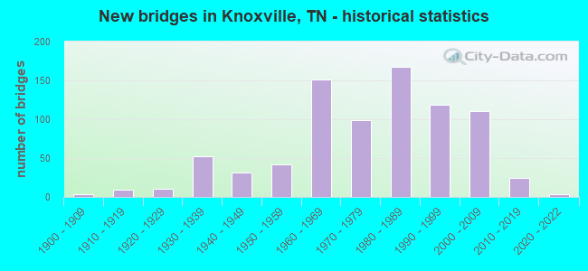
- New bridges - historical statistics
- 1Before 1900
- 31900-1909
- 91910-1919
- 111920-1929
- 521930-1939
- 311940-1949
- 421950-1959
- 1511960-1969
- 991970-1979
- 1681980-1989
- 1191990-1999
- 1112000-2009
- 242010-2019
- 32020-2022
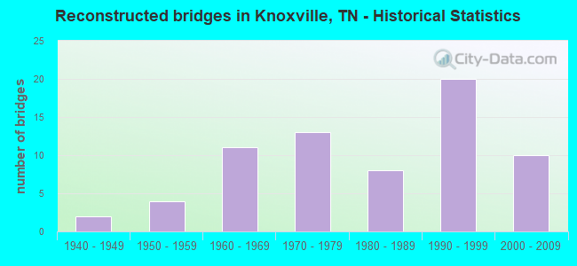
- Reconstructed bridges - Historical Statistics
- 21940-1949
- 41950-1959
- 111960-1969
- 131970-1979
- 81980-1989
- 201990-1999
- 102000-2009
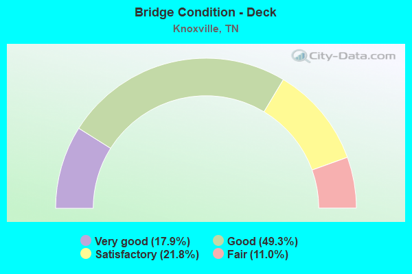
- Bridge Condition - Deck
- 17.9%Very good
- 49.3%Good
- 21.8%Satisfactory
- 11.0%Fair
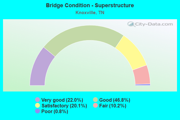
- Bridge Condition - Superstructure
- 22.0%Very good
- 46.8%Good
- 20.1%Satisfactory
- 10.2%Fair
- 0.8%Poor
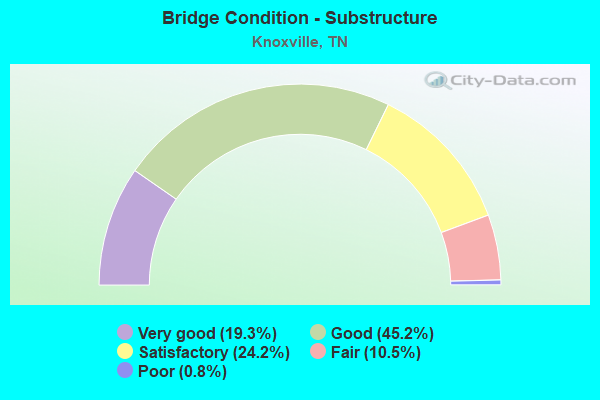
- Bridge Condition - Substructure
- 19.3%Very good
- 45.2%Good
- 24.2%Satisfactory
- 10.5%Fair
- 0.8%Poor
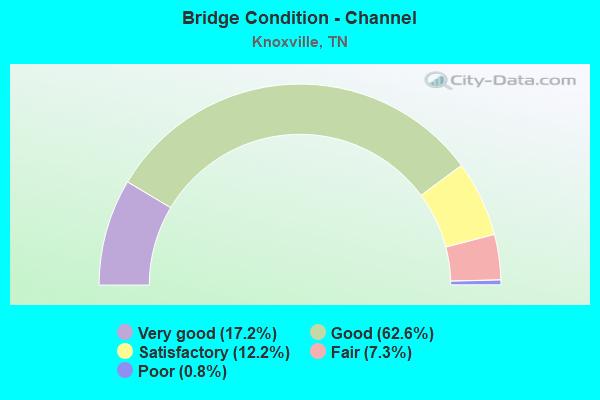
- Bridge Condition - Channel
- 17.2%Very good
- 62.6%Good
- 12.2%Satisfactory
- 7.3%Fair
- 0.8%Poor
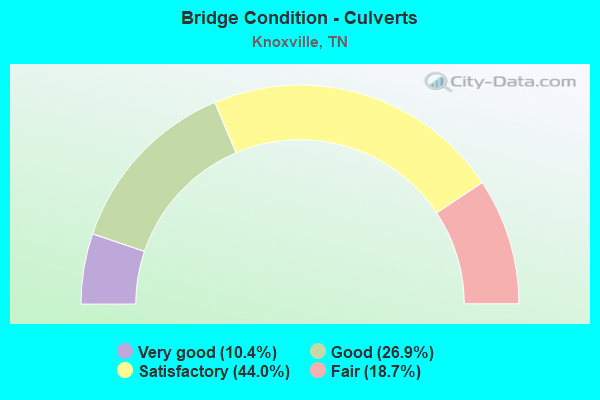
- Bridge Condition - Culverts
- 10.4%Very good
- 26.9%Good
- 44.0%Satisfactory
- 18.7%Fair
Find on map >> Show street view
Structure Number: 47SR1580011, Location: .5 M NW OF SR62 (Lat: 35.967831, Lng: -83.916325), Route carried "on" structure: State highway 158, Year Built: 1972, Status: Open, Structure Length: 0.82m (2.69ft), Average Daily Traffic: 13,490 (year 2020), Truck Traffic: 9%, Average Future Daily Traffic: 7,840 (year 2040), Design Load: HS 20, Features Intersected: FIRST CREEK
Minimum Vertical Clearance: 30+ m (98+ ft), Kilometerpoint: 0.080, Lanes on structure: 4, Base Highway Network: Yes, Owner: State Highway Agency, Approaching Roadway Width: 30.7m (100.7ft), Skew: 6 degrees, Material/Design: Concrete continuous, Design/Construction: Culvert, Number Of Spans In Main Unit: 2, Length of Maximum Span: 3.7m (12.1ft)
Condition: Channel: Very good, Culverts: Satisfactory, Operating Rating: 54.0 metric tons, Method Used To Determine Operating Rating: Field evaluation and documented engineering judgment, Inventory Rating: 32.4 metric tons, Method Used To Determine Inventory Rating: Field evaluation and documented engineering judgment, Structural Evaluation: Equal to present minimum criteria, Waterway Adequacy: Better than present minimum criteria, Approach Roadway Alignment: Equal to present desirable criteria, Length Of Structure Improvement: 0.82m (2.69ft), Designated Inspection Frequency: Every 24 months, Inspection Date: January 2022, Bridge Improvement Cost: $248,000, Roadway Improvement Cost: $25,000, Total Project Cost: $373,000 ( Estimate for 2020)
Find on map >> Show street view
Structure Number: 47SR1580013, Location: 1.1 M N OF SR1 (Lat: 35.961750, Lng: -83.914467), Route carried "on" structure: City street 129, Year Built: 1935, Status: Open, Structure Length: 19.23m (63.09ft), Average Daily Traffic: 7,475 (year 2020), Truck Traffic: 3%, Average Future Daily Traffic: 5,104 (year 2040), Features Intersected: SR 158 & NFA A140
Minimum Vertical Clearance: 30+ m (98+ ft), Kilometerpoint: 0.724, Lanes on structure: 3, Lanes under structure: 3, Owner: City or Municipal Highway Agency, Approaching Roadway Width: 11.0m (36.1ft), Material/Design: Concrete, Design/Construction: Arch - Deck, Number Of Spans In Main Unit: 5, Number Of Approach Spans: 2, Length of Maximum Span: 45.7m (149.9ft), Curb or Sidewalk Widths: Left: 1.9m (6.2ft), Right: 2.8m (9.2ft), Curb-To-Curb Width: 11.0m (36.1ft), Out-to-Out Width: 11.8m (38.7ft)
Condition: Deck: Good, Superstructure: Satisfactory, Substructure: Satisfactory, Operating Rating: 36.0 metric tons, Method Used To Determine Operating Rating: Field evaluation and documented engineering judgment, Inventory Rating: 24.3 metric tons, Method Used To Determine Inventory Rating: Field evaluation and documented engineering judgment, Structural Evaluation: Equal to present minimum criteria, Deck Geometry: High priority of replacement, Underclear: High priority of corrective action, Approach Roadway Alignment: Equal to present desirable criteria, Length Of Structure Improvement: 19.23m (63.09ft), Designated Inspection Frequency: Every 24 months, Inspection Date: June 2020, Bridge Improvement Cost: $4,026,000, Roadway Improvement Cost: $403,000, Total Project Cost: $6,040,000 ( Estimate for 2020), Deck Structure Type: Concrete Cast-file-Place, Wearing Surface/Protective System: Wearing Surface: Bituminous
Find on map >> Show street view
Structure Number: 47SR1580021, Location: 1.4 M N OF WILLOW ST (Lat: 35.968433, Lng: -83.916750), Route carried "on" structure: State highway 1, Year Built: 1972, Status: Open, Structure Length: 5.50m (18.04ft), Average Daily Traffic: 17,449 (year 2020), Truck Traffic: 9%, Average Future Daily Traffic: 27,918 (year 2042), Design Load: HS 20, Features Intersected: FIRST CREEK
Minimum Vertical Clearance: 30+ m (98+ ft), Kilometerpoint: 28.260, Lanes on structure: 4, Base Highway Network: Yes, Owner: State Highway Agency, Approaching Roadway Width: 18.3m (60.0ft), Skew: 1 degrees, Material/Design: Concrete continuous, Design/Construction: Box Beam or Girders - Single/Spread, Number Of Spans In Main Unit: 2, Length of Maximum Span: 22.8m (74.8ft), Curb-To-Curb Width: 18.4m (60.4ft), Out-to-Out Width: 19.6m (64.3ft)
Condition: Deck: Satisfactory, Superstructure: Satisfactory, Substructure: Good, Channel: Good, Operating Rating: 80.1 metric tons, Method Used To Determine Operating Rating: Load Factor (LF), Inventory Rating: 32.4 metric tons, Method Used To Determine Inventory Rating: Load Factor (LF), Structural Evaluation: Equal to present minimum criteria, Deck Geometry: Somewhat better than minimum adequacy, Waterway Adequacy: Better than present minimum criteria, Approach Roadway Alignment: Equal to present minimum criteria, Designated Inspection Frequency: Every 24 months, Inspection Date: January 2022, Deck Structure Type: Concrete Cast-file-Place, Wearing Surface/Protective System: Wearing Surface: Bituminous
Find on map >> Show street view
Structure Number: 47SR1580035, Location: DOWNTOWN KNOXVILLE (Lat: 35.963117, Lng: -83.915383), Route carried "on" structure: Ramp City street 3776, Year Built: 1973, Status: Open, Structure Length: 12.53m (41.11ft), Average Daily Traffic: 2,643 (year 2020), Truck Traffic: 9%, Average Future Daily Traffic: 4,229 (year 2042), Design Load: H 20, Features Intersected: FAU 3776 / S. CENTRAL AV
Minimum Vertical Clearance: 30+ m (98+ ft), Kilometerpoint: 0.225, Lanes on structure: 2, Lanes under structure: 2, Base Highway Network: Yes, Owner: City or Municipal Highway Agency, Approaching Roadway Width: 10.4m (34.1ft), Material/Design: Concrete continuous, Design/Construction: Box Beam or Girders - Multiple, Number Of Spans In Main Unit: 6, Length of Maximum Span: 26.2m (86.0ft), Curb-To-Curb Width: 11.2m (36.7ft), Out-to-Out Width: 12.3m (40.4ft)
Condition: Deck: Good, Superstructure: Good, Substructure: Satisfactory, Operating Rating: 44.1 metric tons, Method Used To Determine Operating Rating: Field evaluation and documented engineering judgment, Inventory Rating: 32.4 metric tons, Method Used To Determine Inventory Rating: Field evaluation and documented engineering judgment, Structural Evaluation: Equal to present minimum criteria, Deck Geometry: Superior to present desirable criteria, Underclear: Somewhat better than minimum adequacy, Approach Roadway Alignment: Equal to present minimum criteria, Designated Inspection Frequency: Every 24 months, Inspection Date: January 2022, Deck Structure Type: Concrete Cast-file-Place, Wearing Surface/Protective System: Wearing Surface: Monolithic Concrete
Find on map >> Show street view
Structure Number: 47SR1580037, Location: DOWNTOWN KNOXVILLE (Lat: 35.964067, Lng: -83.915517), Route carried "on" structure: City street 33, Year Built: 2006, Status: Open, Structure Length: 17.15m (56.27ft), Average Daily Traffic: 2,778 (year 2020), Truck Traffic: 3%, Average Future Daily Traffic: 4,448 (year 2040), Design Load: HS 20, Features Intersected: W. CHURCH AVE / 5 RTS
Minimum Vertical Clearance: 30+ m (98+ ft), Kilometerpoint: 0.612, Lanes on structure: 2, Lanes under structure: 13, Owner: City or Municipal Highway Agency, Approaching Roadway Width: 12.2m (40.0ft), Material/Design: Steel continuous, Design/Construction: Stringer/Multi-beam, Number Of Spans In Main Unit: 6, Length of Maximum Span: 30.4m (99.7ft), Curb or Sidewalk Widths: Left: 2.1m (6.9ft), Right: 2.1m (6.9ft), Curb-To-Curb Width: 12.2m (40.0ft), Out-to-Out Width: 17.1m (56.1ft)
Condition: Deck: Very good, Superstructure: Very good, Substructure: Very good, Operating Rating: 64.8 metric tons, Method Used To Determine Operating Rating: Load Factor (LF), Inventory Rating: 32.4 metric tons, Method Used To Determine Inventory Rating: Load Factor (LF), Structural Evaluation: Equal to present desirable criteria, Deck Geometry: Equal to present minimum criteria, Underclear: High priority of corrective action, Approach Roadway Alignment: Equal to present desirable criteria, Designated Inspection Frequency: Every 24 months, Inspection Date: June 2020, Deck Structure Type: Concrete Cast-file-Place, Wearing Surface/Protective System: Wearing Surface: Integral Concrete, Deck Protection: Epoxy Coated Reinforcing
Find on map >> Show street view
Structure Number: 47SR1580045, Location: DOWNTOWN KNOXVILLE (Lat: 35.969056, Lng: -83.916667), Route carried "on" structure: City street 3788, Year Built: 2006, Status: Open, Structure Length: 7.04m (23.10ft), Average Daily Traffic: 11,115 (year 2020), Truck Traffic: 4%, Average Future Daily Traffic: 16,816 (year 2040), Design Load: H 20, Features Intersected: SUMMIT HILL DR / J.WHITE
Minimum Vertical Clearance: 30+ m (98+ ft), Kilometerpoint: 0.000, Lanes on structure: 6, Lanes under structure: 7, Owner: State Highway Agency, Approaching Roadway Width: 27.4m (89.9ft), Skew: 12 degrees, Material/Design: Prestressed concrete continuous, Design/Construction: Stringer/Multi-beam, Number Of Spans In Main Unit: 2, Length of Maximum Span: 34.7m (113.8ft), Curb or Sidewalk Widths: Left: 2.1m (6.9ft), Right: 2.1m (6.9ft), Curb-To-Curb Width: 23.2m (76.1ft), Out-to-Out Width: 28.0m (91.9ft)
Condition: Deck: Good, Superstructure: Very good, Substructure: Very good, Operating Rating: 52.2 metric tons, Method Used To Determine Operating Rating: Load Factor (LF), Inventory Rating: 31.5 metric tons, Method Used To Determine Inventory Rating: Load Factor (LF), Structural Evaluation: Better than present minimum criteria, Deck Geometry: Meets minimum limits, Underclear: Equal to present minimum criteria, Approach Roadway Alignment: Equal to present desirable criteria, Designated Inspection Frequency: Every 24 months, Inspection Date: January 2022, Deck Structure Type: Concrete Cast-file-Place, Wearing Surface/Protective System: Wearing Surface: Monolithic Concrete, Deck Protection: Epoxy Coated Reinforcing
Find on map >> Show street view
Structure Number: 47SR1580049, Location: IN KNOXVILLE (Lat: 35.962167, Lng: -83.914867), Route carried "on" structure: Ramp City street 3776, Year Built: 1973, Status: Open, Structure Length: 20.74m (68.04ft), Average Daily Traffic: 4,153 (year 2020), Truck Traffic: 9%, Average Future Daily Traffic: 6,645 (year 2042), Design Load: HS 20+Mod, Features Intersected: FAU 3776 / 2 RTS.
Minimum Vertical Clearance: 30+ m (98+ ft), Kilometerpoint: 0.563, Lanes on structure: 1, Lanes under structure: 6, Base Highway Network: Yes, Owner: State Highway Agency, Approaching Roadway Width: 8.5m (27.9ft), Material/Design: Concrete continuous, Design/Construction: Box Beam or Girders - Multiple, Number Of Spans In Main Unit: 7, Length of Maximum Span: 29.4m (96.5ft), Curb-To-Curb Width: 8.7m (28.5ft), Out-to-Out Width: 9.8m (32.2ft)
Condition: Deck: Good, Superstructure: Good, Substructure: Satisfactory, Operating Rating: 44.1 metric tons, Method Used To Determine Operating Rating: Load and Resistance Factor Rating (LRFR) rating reported by rating factor(RF) method using HL-93 loadings, Inventory Rating: 34.0 metric tons, Method Used To Determine Inventory Rating: Load and Resistance Factor Rating (LRFR) rating reported by rating factor(RF) method using HL-93 loadings, Structural Evaluation: Equal to present minimum criteria, Deck Geometry: Superior to present desirable criteria, Underclear: Somewhat better than minimum adequacy, Approach Roadway Alignment: Equal to present minimum criteria, Designated Inspection Frequency: Every 24 months, Inspection Date: January 2022, Deck Structure Type: Concrete Cast-file-Place, Wearing Surface/Protective System: Wearing Surface: Monolithic Concrete
Find on map >> Show street view
Structure Number: 47SR1580061, Location: .3 M W OF SR33 (Lat: 35.981867, Lng: -83.917533), Route carried "on" structure: City street 5666, Year Built: 2006, Status: Open, Structure Length: 1.28m (4.20ft), Average Daily Traffic: 12,546 (year 2020), Truck Traffic: 4%, Average Future Daily Traffic: 22,272 (year 2040), Design Load: HS 20, Features Intersected: HOF DR. / SR158 TUNNEL
Minimum Vertical Clearance: 30+ m (98+ ft), Kilometerpoint: 0.764, Lanes on structure: 5, Lanes under structure: 2, Owner: State Highway Agency, Approaching Roadway Width: 28.0m (91.9ft), Material/Design: Concrete, Design/Construction: Arch - Deck, Number Of Spans In Main Unit: 1, Length of Maximum Span: 12.8m (42.0ft), Curb-To-Curb Width: 59.3m (194.6ft), Out-to-Out Width: 60.3m (197.8ft)
Condition: Deck: Very good, Superstructure: Very good, Substructure: Good, Operating Rating: 44.1 metric tons, Method Used To Determine Operating Rating: Assigned rating based on Load Factor Design (LFD) reported in metric tons, Inventory Rating: 32.4 metric tons, Method Used To Determine Inventory Rating: Assigned rating based on Load Factor Design (LFD) reported in metric tons, Structural Evaluation: Better than present minimum criteria, Deck Geometry: Superior to present desirable criteria, Underclear: Equal to present minimum criteria, Approach Roadway Alignment: Equal to present desirable criteria, Designated Inspection Frequency: Every 24 months, Inspection Date: January 2022
Find on map >> Show street view
Structure Number: 47SR1580065, Location: CITY OF KNOXVILLE (Lat: 35.974367, Lng: -83.916983), Route carried "on" structure: State highway 158, Year Built: 2006, Status: Open, Structure Length: 5.18m (16.99ft), Average Daily Traffic: 33,144 (year 2020), Truck Traffic: 13%, Average Future Daily Traffic: 61,440 (year 2040), Design Load: HS 20, Features Intersected: J WHITE PK/OLD MAGNOLIA
Minimum Vertical Clearance: 30+ m (98+ ft), Kilometerpoint: 1.577, Lanes on structure: 4, Lanes under structure: 5, Base Highway Network: Yes, Owner: State Highway Agency, Approaching Roadway Width: 21.9m (71.9ft), Material/Design: Prestressed concrete continuous, Design/Construction: Box Beam or Girders - Single/Spread, Number Of Spans In Main Unit: 3, Length of Maximum Span: 28.8m (94.5ft), Curb-To-Curb Width: 21.9m (71.9ft), Out-to-Out Width: 22.6m (74.1ft)
Condition: Deck: Good, Superstructure: Good, Substructure: Very good, Operating Rating: 49.5 metric tons, Method Used To Determine Operating Rating: Load Factor (LF), Inventory Rating: 28.8 metric tons, Method Used To Determine Inventory Rating: Load Factor (LF), Structural Evaluation: Better than present minimum criteria, Deck Geometry: Better than present minimum criteria, Underclear: Somewhat better than minimum adequacy, Approach Roadway Alignment: Equal to present desirable criteria, Designated Inspection Frequency: Every 24 months, Inspection Date: January 2022, Deck Structure Type: Concrete Cast-file-Place, Wearing Surface/Protective System: Wearing Surface: Monolithic Concrete, Deck Protection: Epoxy Coated Reinforcing
Find on map >> Show street view
Structure Number: 47SR1620003, Location: 1 M SW OF CONARD MILL RD (Lat: 35.964000, Lng: -84.173233), Route carried "on" structure: State highway 162, Year Built: 1969, Status: Open, Structure Length: 5.64m (18.50ft), Average Daily Traffic: 41,210 (year 2020), Truck Traffic: 9%, Average Future Daily Traffic: 65,936 (year 2041), Design Load: HS 20, Features Intersected: BEAVER CREEK
Minimum Vertical Clearance: 30+ m (98+ ft), Kilometerpoint: 1.931, Lanes on structure: 2, Base Highway Network: Yes, Owner: State Highway Agency, Approaching Roadway Width: 13.5m (44.3ft), Skew: 10 degrees, Material/Design: Prestressed concrete continuous, Design/Construction: Stringer/Multi-beam, Number Of Spans In Main Unit: 2, Length of Maximum Span: 25.2m (82.7ft), Curb-To-Curb Width: 12.3m (40.4ft), Out-to-Out Width: 13.5m (44.3ft)
Condition: Deck: Good, Superstructure: Good, Substructure: Good, Channel: Good, Operating Rating: 53.1 metric tons, Method Used To Determine Operating Rating: Load Factor (LF), Inventory Rating: 31.5 metric tons, Method Used To Determine Inventory Rating: Load Factor (LF), Structural Evaluation: Better than present minimum criteria, Deck Geometry: Better than present minimum criteria, Waterway Adequacy: Better than present minimum criteria, Approach Roadway Alignment: Equal to present desirable criteria, Designated Inspection Frequency: Every 24 months, Underwater Inspection Frequency: Every 36 months, Inspection Date: Febuary 2022, Underwater Inspection Date: May 2021, Deck Structure Type: Concrete Cast-file-Place, Wearing Surface/Protective System: Wearing Surface: Bituminous
Find on map >> Show street view
Structure Number: 47SR1620005, Location: .7 M SW OF CARMICHAEL RD (Lat: 35.950000, Lng: -84.157817), Route carried "on" structure: State highway 162, Year Built: 1969, Status: Open, Structure Length: 4.76m (15.62ft), Average Daily Traffic: 56,264 (year 2020), Truck Traffic: 9%, Average Future Daily Traffic: 90,022 (year 2041), Design Load: HS 20, Features Intersected: SR162-RL /HARDIN VALLEY
Minimum Vertical Clearance: 30+ m (98+ ft), Kilometerpoint: 4.039, Lanes on structure: 2, Lanes under structure: 2, Base Highway Network: Yes, Owner: State Highway Agency, Approaching Roadway Width: 13.4m (44.0ft), Skew: 10 degrees, Material/Design: Prestressed concrete continuous, Design/Construction: Stringer/Multi-beam, Number Of Spans In Main Unit: 2, Length of Maximum Span: 22.4m (73.5ft), Curb-To-Curb Width: 12.4m (40.7ft), Out-to-Out Width: 13.5m (44.3ft)
Condition: Deck: Good, Superstructure: Good, Substructure: Satisfactory, Operating Rating: 28.8 metric tons, Method Used To Determine Operating Rating: Load and Resistance Factor Rating (LRFR) rating reported by rating factor(RF) method using HL-93 loadings, Inventory Rating: 22.4 metric tons, Method Used To Determine Inventory Rating: Load and Resistance Factor Rating (LRFR) rating reported by rating factor(RF) method using HL-93 loadings, Structural Evaluation: Somewhat better than minimum adequacy, Deck Geometry: Better than present minimum criteria, Underclear: Meets minimum limits, Approach Roadway Alignment: Equal to present desirable criteria, Designated Inspection Frequency: Every 24 months, Inspection Date: Febuary 2022, Deck Structure Type: Concrete Cast-file-Place, Wearing Surface/Protective System: Wearing Surface: Bituminous
Find on map >> Show street view
Structure Number: 47SR1620006, Location: .7 M SW OF CARMICHAEL RD (Lat: 35.950133, Lng: -84.157500), Route carried "on" structure: State highway 162, Year Built: 1969, Status: Open, Structure Length: 5.06m (16.60ft), Average Daily Traffic: 56,264 (year 2020), Truck Traffic: 9%, Average Future Daily Traffic: 90,022 (year 2041), Design Load: HS 20, Features Intersected: SR162-LL /HARDIN VALLEY
Minimum Vertical Clearance: 30+ m (98+ ft), Kilometerpoint: 4.039, Lanes on structure: 2, Lanes under structure: 4, Base Highway Network: Yes, Owner: State Highway Agency, Approaching Roadway Width: 12.8m (42.0ft), Skew: 10 degrees, Material/Design: Prestressed concrete continuous, Design/Construction: Stringer/Multi-beam, Number Of Spans In Main Unit: 2, Length of Maximum Span: 23.7m (77.8ft), Curb-To-Curb Width: 12.4m (40.7ft), Out-to-Out Width: 13.5m (44.3ft)
Condition: Deck: Good, Superstructure: Good, Substructure: Satisfactory, Operating Rating: 35.0 metric tons, Method Used To Determine Operating Rating: Load and Resistance Factor Rating (LRFR) rating reported by rating factor(RF) method using HL-93 loadings, Inventory Rating: 24.3 metric tons, Method Used To Determine Inventory Rating: Load and Resistance Factor Rating (LRFR) rating reported by rating factor(RF) method using HL-93 loadings, Structural Evaluation: Equal to present minimum criteria, Deck Geometry: Better than present minimum criteria, Underclear: Meets minimum limits, Approach Roadway Alignment: Equal to present desirable criteria, Designated Inspection Frequency: Every 24 months, Inspection Date: Febuary 2022, Deck Structure Type: Concrete Cast-file-Place, Wearing Surface/Protective System: Wearing Surface: Bituminous
Find on map >> Show street view
Structure Number: 47SR1620007, Location: .4 M SW OF MERCURY DR (Lat: 35.934900, Lng: -84.144983), Route carried "on" structure: State highway 162, Year Built: 1968, Status: Open, Structure Length: 5.07m (16.63ft), Average Daily Traffic: 56,264 (year 2020), Truck Traffic: 9%, Average Future Daily Traffic: 107,376 (year 2040), Design Load: HS 20, Features Intersected: SR162-NB / LOVELL RD
Minimum Vertical Clearance: 30+ m (98+ ft), Kilometerpoint: 6.083, Lanes on structure: 2, Lanes under structure: 4, Base Highway Network: Yes, Owner: State Highway Agency, Approaching Roadway Width: 12.5m (41.0ft), Skew: 16 degrees, Material/Design: Steel continuous, Design/Construction: Stringer/Multi-beam, Number Of Spans In Main Unit: 3, Length of Maximum Span: 19.8m (65.0ft), Curb-To-Curb Width: 12.4m (40.7ft), Out-to-Out Width: 13.6m (44.6ft)
Condition: Deck: Good, Superstructure: Satisfactory, Substructure: Good, Operating Rating: 44.1 metric tons, Method Used To Determine Operating Rating: Load Factor (LF), Inventory Rating: 26.1 metric tons, Method Used To Determine Inventory Rating: Load Factor (LF), Structural Evaluation: Equal to present minimum criteria, Deck Geometry: Better than present minimum criteria, Underclear: Meets minimum limits, Approach Roadway Alignment: Equal to present desirable criteria, Designated Inspection Frequency: Every 24 months, Inspection Date: Febuary 2022, Deck Structure Type: Concrete Cast-file-Place, Wearing Surface/Protective System: Wearing Surface: Bituminous
Find on map >> Show street view
Structure Number: 47SR1620008, Location: .4 M SW OF MERCURY RD (Lat: 35.935083, Lng: -84.145033), Route carried "on" structure: State highway 162, Year Built: 1968, Status: Open, Structure Length: 5.07m (16.63ft), Average Daily Traffic: 56,264 (year 2020), Truck Traffic: 9%, Average Future Daily Traffic: 107,376 (year 2040), Design Load: HS 20, Features Intersected: SR162-SB / LOVELL RD
Minimum Vertical Clearance: 30+ m (98+ ft), Kilometerpoint: 6.083, Lanes on structure: 2, Lanes under structure: 4, Base Highway Network: Yes, Owner: State Highway Agency, Approaching Roadway Width: 12.8m (42.0ft), Skew: 16 degrees, Material/Design: Steel continuous, Design/Construction: Stringer/Multi-beam, Number Of Spans In Main Unit: 3, Length of Maximum Span: 19.8m (65.0ft), Curb-To-Curb Width: 12.4m (40.7ft), Out-to-Out Width: 13.6m (44.6ft)
Condition: Deck: Satisfactory, Superstructure: Fair, Substructure: Good, Operating Rating: 45.9 metric tons, Method Used To Determine Operating Rating: Load Factor (LF), Inventory Rating: 27.0 metric tons, Method Used To Determine Inventory Rating: Load Factor (LF), Structural Evaluation: Somewhat better than minimum adequacy, Deck Geometry: Better than present minimum criteria, Underclear: Meets minimum limits, Approach Roadway Alignment: Equal to present desirable criteria, Designated Inspection Frequency: Every 24 months, Inspection Date: Febuary 2022, Deck Structure Type: Concrete Cast-file-Place, Wearing Surface/Protective System: Wearing Surface: Bituminous
Find on map >> Show street view
Structure Number: 47SR1620009, Location: JUST S OF SR162-SR131 JCT (Lat: 35.931317, Lng: -84.141317), Route carried "on" structure: County highway 5941, Year Built: 1973, Status: Open, Structure Length: 8.66m (28.41ft), Average Daily Traffic: 3,286 (year 2020), Truck Traffic: 3%, Average Future Daily Traffic: 5,184 (year 2041), Design Load: HS 20, Features Intersected: BOB GRAY RD. / SR 162, Facility Carried by Structure: NFA C056
Minimum Vertical Clearance: 30+ m (98+ ft), Kilometerpoint: 4.715, Lanes on structure: 2, Lanes under structure: 4, Owner: State Highway Agency, Approaching Roadway Width: 9.8m (32.2ft), Skew: 2 degrees, Material/Design: Prestressed concrete, Design/Construction: Stringer/Multi-beam, Number Of Spans In Main Unit: 4, Length of Maximum Span: 23.5m (77.1ft), Curb-To-Curb Width: 10.4m (34.1ft), Out-to-Out Width: 11.0m (36.1ft)
Condition: Deck: Satisfactory, Superstructure: Good, Substructure: Good, Operating Rating: 63.0 metric tons, Method Used To Determine Operating Rating: Load Factor (LF), Inventory Rating: 32.4 metric tons, Method Used To Determine Inventory Rating: Load Factor (LF), Structural Evaluation: Better than present minimum criteria, Deck Geometry: Somewhat better than minimum adequacy, Underclear: Superior to present desirable criteria, Approach Roadway Alignment: Equal to present minimum criteria, Designated Inspection Frequency: Every 24 months, Inspection Date: Febuary 2022, Deck Structure Type: Concrete Cast-file-Place, Wearing Surface/Protective System: Wearing Surface: Monolithic Concrete
Find on map >> Show street view
Structure Number: 47SR1620039, Location: .3MI FROM JCT I40 & SR162 (Lat: 35.914750, Lng: -84.123267), Route carried "on" structure: State highway 162, Year Built: 2000, Status: Open, Structure Length: 6.04m (19.82ft), Average Daily Traffic: 88,026 (year 2020), Truck Traffic: 13%, Average Future Daily Traffic: 124,320 (year 2040), Design Load: HS 20, Features Intersected: SR162/162-RP TO I40 EAST
Minimum Vertical Clearance: 30+ m (98+ ft), Kilometerpoint: 9.077, Lanes on structure: 4, Lanes under structure: 2, Base Highway Network: Yes, Owner: State Highway Agency, Approaching Roadway Width: 25.6m (84.0ft), Skew: 33 degrees, Material/Design: Prestressed concrete continuous, Design/Construction: Stringer/Multi-beam, Number Of Spans In Main Unit: 3, Length of Maximum Span: 30.2m (99.1ft), Curb-To-Curb Width: 25.6m (84.0ft), Out-to-Out Width: 27.0m (88.6ft)
Condition: Deck: Good, Superstructure: Good, Substructure: Good, Operating Rating: 45.9 metric tons, Method Used To Determine Operating Rating: Load Factor (LF), Inventory Rating: 27.0 metric tons, Method Used To Determine Inventory Rating: Load Factor (LF), Structural Evaluation: Equal to present minimum criteria, Deck Geometry: Superior to present desirable criteria, Underclear: Superior to present desirable criteria, Approach Roadway Alignment: Equal to present desirable criteria, Length Of Structure Improvement: 6.04m (19.82ft), Designated Inspection Frequency: Every 24 months, Inspection Date: Febuary 2022, Bridge Improvement Cost: $2,592,000, Roadway Improvement Cost: $260,000, Total Project Cost: $3,889,000 ( Estimate for 2020), Deck Structure Type: Concrete Cast-file-Place, Wearing Surface/Protective System: Wearing Surface: Monolithic Concrete, Deck Protection: Epoxy Coated Reinforcing
Find on map >> Show street view
Structure Number: 47SR1620047, Location: OVER SR162 (Lat: 35.924733, Lng: -84.133483), Route carried "on" structure: County highway 4832, Year Built: 1999, Status: Open, Structure Length: 8.29m (27.20ft), Average Daily Traffic: 8,530 (year 2020), Truck Traffic: 4%, Average Future Daily Traffic: 15,904 (year 2040), Design Load: HS 20, Features Intersected: FAU 4832 / SR162
Minimum Vertical Clearance: 30+ m (98+ ft), Kilometerpoint: 4.353, Lanes on structure: 5, Lanes under structure: 6, Owner: State Highway Agency, Approaching Roadway Width: 19.5m (64.0ft), Skew: 2 degrees, Material/Design: Prestressed concrete continuous, Design/Construction: Stringer/Multi-beam, Number Of Spans In Main Unit: 2, Length of Maximum Span: 41.5m (136.2ft), Curb-To-Curb Width: 20.0m (65.6ft), Out-to-Out Width: 20.6m (67.6ft)
Condition: Deck: Good, Superstructure: Good, Substructure: Good, Operating Rating: 54.9 metric tons, Method Used To Determine Operating Rating: Load Factor (LF), Inventory Rating: 32.4 metric tons, Method Used To Determine Inventory Rating: Load Factor (LF), Structural Evaluation: Better than present minimum criteria, Deck Geometry: Somewhat better than minimum adequacy, Underclear: Better than present minimum criteria, Approach Roadway Alignment: Equal to present desirable criteria, Designated Inspection Frequency: Every 24 months, Inspection Date: Febuary 2022, Deck Structure Type: Concrete Precast Panels, Wearing Surface/Protective System: Wearing Surface: Monolithic Concrete, Deck Protection: Epoxy Coated Reinforcing
Find on map >> Show street view
Structure Number: 47SR1680001, Location: JUST W OF US441-SR168 (Lat: 35.900850, Lng: -83.856300), Route carried "on" structure: County highway 942, Year Built: 1973, Status: Open, Structure Length: 4.49m (14.73ft), Average Daily Traffic: 780 (year 2022), Truck Traffic: 2%, Average Future Daily Traffic: 1,248 (year 2040), Design Load: HS 20, Features Intersected: DICK FORD ROAD / SR 168
Minimum Vertical Clearance: 30+ m (98+ ft), Kilometerpoint: 0.476, Lanes on structure: 2, Lanes under structure: 2, Owner: State Highway Agency, Approaching Roadway Width: 8.5m (27.9ft), Skew: 4 degrees, Material/Design: Prestressed concrete, Design/Construction: Box Beam or Girders - Multiple, Number Of Spans In Main Unit: 1, Length of Maximum Span: 42.8m (140.4ft), Curb-To-Curb Width: 9.9m (32.5ft), Out-to-Out Width: 11.0m (36.1ft)
Condition: Deck: Good, Superstructure: Satisfactory, Substructure: Satisfactory, Operating Rating: 44.1 metric tons, Method Used To Determine Operating Rating: Assigned rating based on Load Factor Design (LFD) reported in metric tons, Inventory Rating: 32.4 metric tons, Method Used To Determine Inventory Rating: Assigned rating based on Load Factor Design (LFD) reported in metric tons, Structural Evaluation: Equal to present minimum criteria, Deck Geometry: Equal to present minimum criteria, Underclear: Better than present minimum criteria, Approach Roadway Alignment: Equal to present minimum criteria, Designated Inspection Frequency: Every 24 months, Inspection Date: Febuary 2022, Deck Structure Type: Concrete Cast-file-Place, Wearing Surface/Protective System: Wearing Surface: Bituminous, Membrane: Preformed Fabric
Find on map >> Show street view
Structure Number: 47SR1690001, Location: JUST W OF I75-N OF I40 JC (Lat: 35.962050, Lng: -83.975883), Route carried "on" structure: State highway 169, Year Built: 1978, Status: Open, Structure Length: 1.21m (3.97ft), Average Daily Traffic: 15,323 (year 2020), Truck Traffic: 4%, Average Future Daily Traffic: 22,736 (year 2040), Design Load: HS 20+Mod, Features Intersected: THIRD CREEK
Minimum Vertical Clearance: 30+ m (98+ ft), Kilometerpoint: 14.870, Lanes on structure: 5, Owner: State Highway Agency, Approaching Roadway Width: 20.6m (67.6ft), Skew: 4 degrees, Material/Design: Concrete continuous, Design/Construction: Culvert, Number Of Spans In Main Unit: 3, Length of Maximum Span: 3.7m (12.1ft)
Condition: Channel: Good, Culverts: Satisfactory, Operating Rating: 89.1 metric tons, Method Used To Determine Operating Rating: Load Factor (LF), Inventory Rating: 32.4 metric tons, Method Used To Determine Inventory Rating: Load Factor (LF), Structural Evaluation: Equal to present minimum criteria, Waterway Adequacy: Better than present minimum criteria, Approach Roadway Alignment: Equal to present minimum criteria, Length Of Structure Improvement: 1.21m (3.97ft), Designated Inspection Frequency: Every 24 months, Inspection Date: Febuary 2022, Bridge Improvement Cost: $409,000, Roadway Improvement Cost: $41,000, Total Project Cost: $614,000 ( Estimate for 2020)
Find on map >> Show street view
Structure Number: 47SR1690005, Location: MIDDLEBROOK PK AT CITY LI (Lat: 35.946867, Lng: -84.053833), Route carried "on" structure: State highway 169, Year Built: 2000, Status: Open, Structure Length: 1.49m (4.89ft), Average Daily Traffic: 15,323 (year 2020), Truck Traffic: 4%, Average Future Daily Traffic: 22,736 (year 2040), Design Load: HS 20, Features Intersected: THIRD CREEK
Minimum Vertical Clearance: 30+ m (98+ ft), Kilometerpoint: 16.963, Lanes on structure: 4, Owner: State Highway Agency, Approaching Roadway Width: 20.3m (66.6ft), Skew: 3 degrees, Material/Design: Concrete continuous, Design/Construction: Culvert, Number Of Spans In Main Unit: 3, Length of Maximum Span: 4.2m (13.8ft)
Condition: Channel: Good, Culverts: Satisfactory, Operating Rating: 54.0 metric tons, Method Used To Determine Operating Rating: Field evaluation and documented engineering judgment, Inventory Rating: 32.4 metric tons, Method Used To Determine Inventory Rating: Field evaluation and documented engineering judgment, Structural Evaluation: Equal to present minimum criteria, Waterway Adequacy: Somewhat better than minimum adequacy, Approach Roadway Alignment: Equal to present desirable criteria, Length Of Structure Improvement: 1.49m (4.89ft), Designated Inspection Frequency: Every 24 months, Inspection Date: Febuary 2022, Bridge Improvement Cost: $423,000, Roadway Improvement Cost: $43,000, Total Project Cost: $635,000 ( Estimate for 2020)
Find on map >> Show street view
Structure Number: 47SR1690007, Location: JUST S OF SR62 (Lat: 35.963583, Lng: -83.945783), Route carried "on" structure: Ramp City street 499, Year Built: 2000, Status: Open, Structure Length: 8.66m (28.41ft), Average Daily Traffic: 2,948 (year 2020), Truck Traffic: 4%, Average Future Daily Traffic: 800 (year 2041), Design Load: HS 20, Features Intersected: 21ST. STREET. / SR169
Minimum Vertical Clearance: 30+ m (98+ ft), Kilometerpoint: 0.338, Lanes on structure: 1, Lanes under structure: 4, Owner: State Highway Agency, Approaching Roadway Width: 9.1m (29.9ft), Skew: 4 degrees, Material/Design: Steel continuous, Design/Construction: Stringer/Multi-beam, Number Of Spans In Main Unit: 3, Length of Maximum Span: 46.0m (150.9ft), Curb-To-Curb Width: 9.1m (29.9ft), Out-to-Out Width: 9.8m (32.2ft)
Condition: Deck: Very good, Superstructure: Very good, Substructure: Very good, Operating Rating: 56.7 metric tons, Method Used To Determine Operating Rating: Load Factor (LF), Inventory Rating: 32.4 metric tons, Method Used To Determine Inventory Rating: Load Factor (LF), Structural Evaluation: Equal to present desirable criteria, Deck Geometry: Superior to present desirable criteria, Underclear: Meets minimum limits, Approach Roadway Alignment: Equal to present desirable criteria, Designated Inspection Frequency: Every 24 months, Inspection Date: October 2020, Deck Structure Type: Concrete Cast-file-Place, Wearing Surface/Protective System: Wearing Surface: Monolithic Concrete, Membrane: Other, Deck Protection: Epoxy Coated Reinforcing
Find on map >> Show street view
Structure Number: 47SR3320015, Location: NEAR FT LOUDON LAKE (Lat: 35.878417, Lng: -84.041300), Route carried "on" structure: State highway 332, Year Built: 1950, Status: Open, Structure Length: 0.93m (3.05ft), Average Daily Traffic: 14,164 (year 2020), Truck Traffic: 4%, Average Future Daily Traffic: 23,520 (year 2040), Design Load: HS 20, Features Intersected: SINKING CREEK
Minimum Vertical Clearance: 30+ m (98+ ft), Kilometerpoint: 13.953, Lanes on structure: 2, Owner: State Highway Agency, Approaching Roadway Width: 7.3m (24.0ft), Skew: 6 degrees, Material/Design: Concrete, Design/Construction: Culvert, Number Of Spans In Main Unit: 1, Length of Maximum Span: 8.2m (26.9ft)
Condition: Channel: Good, Culverts: Satisfactory, Operating Rating: 54.0 metric tons, Method Used To Determine Operating Rating: Field evaluation and documented engineering judgment, Inventory Rating: 32.4 metric tons, Method Used To Determine Inventory Rating: Field evaluation and documented engineering judgment, Structural Evaluation: Equal to present minimum criteria, Waterway Adequacy: Better than present minimum criteria, Approach Roadway Alignment: Equal to present minimum criteria, Designated Inspection Frequency: Every 24 months, Inspection Date: March 2022
Find on map >> Show street view
Structure Number: 47SR4500001, Location: NEAR NEYLAND DR (Lat: 35.948867, Lng: -83.937217), Route carried "on" structure: State highway 450, Year Built: 2002, Status: Open, Structure Length: 18.83m (61.78ft), Average Daily Traffic: 6,859 (year 2020), Truck Traffic: 4%, Average Future Daily Traffic: 10,928 (year 2040), Design Load: HS 20, Features Intersected: SOU. RR & THIRD CR
Minimum Vertical Clearance: 30+ m (98+ ft), Kilometerpoint: 0.354, Lanes on structure: 4, Owner: State Highway Agency, Approaching Roadway Width: 17.7m (58.1ft), Material/Design: Steel continuous, Design/Construction: Stringer/Multi-beam, Number Of Spans In Main Unit: 3, Length of Maximum Span: 78.9m (258.9ft), Curb or Sidewalk Widths: Left: 0.0m, Right: 3.7m (12.1ft), Curb-To-Curb Width: 22.1m (72.5ft), Out-to-Out Width: 22.9m (75.1ft)
Condition: Deck: Good, Superstructure: Good, Substructure: Very good, Channel: Good, Operating Rating: 60.3 metric tons, Method Used To Determine Operating Rating: Load Factor (LF), Inventory Rating: 32.4 metric tons, Method Used To Determine Inventory Rating: Load Factor (LF), Structural Evaluation: Better than present minimum criteria, Deck Geometry: Superior to present desirable criteria, Underclear: Superior to present desirable criteria, Waterway Adequacy: Equal to present minimum criteria, Approach Roadway Alignment: Equal to present desirable criteria, Designated Inspection Frequency: Every 24 months, Inspection Date: Febuary 2022, Deck Structure Type: Concrete Cast-file-Place, Wearing Surface/Protective System: Wearing Surface: Monolithic Concrete, Deck Protection: Epoxy Coated Reinforcing
Find on map >> Show street view
Structure Number: 47X00710001, Location: S. KNOXVILLE BLVD. (Lat: 35.960967, Lng: -83.897050), Route carried "on" structure: State highway SR634, Year Built: 1983, Status: Open, Structure Length: 57.88m (189.90ft), Average Daily Traffic: 12,490 (year 2020), Truck Traffic: 13%, Average Future Daily Traffic: 19,984 (year 2042), Design Load: HS 20+Mod, Features Intersected: TN R-A132-SOURR-FAU1124, Facility Carried by Structure: FAP 71
Minimum Vertical Clearance: 30+ m (98+ ft), Kilometerpoint: 0.225, Lanes on structure: 6, Lanes under structure: 4, Base Highway Network: Yes, Owner: State Highway Agency, Approaching Roadway Width: 36.6m (120.1ft), Skew: 20 degrees, Navigation Control: Yes ( Vertical Clearance: 7.6m (24.9ft), Horizontal Clearance: 106.6m (349.7ft)), Material/Design: Steel continuous, Design/Construction: Stringer/Multi-beam, Number Of Spans In Main Unit: 3, Number Of Approach Spans: 9, Length of Maximum Span: 118.9m (390.1ft), Curb-To-Curb Width: 36.0m (118.1ft), Out-to-Out Width: 36.6m (120.1ft)
Condition: Deck: Satisfactory, Superstructure: Good, Substructure: Fair, Channel: Fair, Operating Rating: 33.0 metric tons, Method Used To Determine Operating Rating: Load and Resistance Factor Rating (LRFR) rating reported by rating factor(RF) method using HL-93 loadings, Inventory Rating: 24.3 metric tons, Method Used To Determine Inventory Rating: Load and Resistance Factor Rating (LRFR) rating reported by rating factor(RF) method using HL-93 loadings, Structural Evaluation: Somewhat better than minimum adequacy, Deck Geometry: Superior to present desirable criteria, Underclear: Superior to present desirable criteria, Waterway Adequacy: Superior to present desirable criteria, Approach Roadway Alignment: Equal to present minimum criteria, Length Of Structure Improvement: 57.88m (189.90ft), Designated Inspection Frequency: Every 24 months, Underwater Inspection Frequency: Every 60 months, Inspection Date: March 2020, Underwater Inspection Date: August 2019, Bridge Improvement Cost: $63,960,000, Roadway Improvement Cost: $6,397,000, Total Project Cost: $95,941,000 ( Estimate for 2022), Deck Structure Type: Concrete Cast-file-Place, Wearing Surface/Protective System: Wearing Surface: Monolithic Concrete, Deck Protection: Epoxy Coated Reinforcing
Find on map >> Show street view
Structure Number: 47000710009, Location: SOUTH KNOXVILLE BLVD (Lat: 35.944317, Lng: -83.896033), Route carried "under" structure: State highway 71, Year Built: 1993, Structure Length: 0. m, Average Daily Traffic: 12,490 (year 2020), Truck Traffic: 13%, Features Intersected: MOODY AVE /S. KNOXVILLE, Facility Carried by Structure: FAU 3781
Minimum Vertical Clearance: 4.88m (16.01ft), Kilometerpoint: 0.000, Lanes on structure: 5, Lanes under structure: 4, Material/Design: Concrete continuous, Design/Construction: Box Beam or Girders - Single/Spread, Length of Maximum Span: 36.0m (118.1ft)
Find on map >> Show street view
Structure Number: 47000710011, Location: SOUTH KNOXVILLE BLVD. (Lat: 35.948883, Lng: -83.895817), Route carried "under" structure: State highway 71, Year Built: 1994, Structure Length: 0. m, Average Daily Traffic: 12,490 (year 2020), Truck Traffic: 13%, Features Intersected: WYNN AVE / S. KNOXVILLE, Facility Carried by Structure: NFA A150
Minimum Vertical Clearance: 5.54m (18.18ft), Kilometerpoint: 0.467, Lanes on structure: 2, Lanes under structure: 4, Material/Design: Concrete continuous, Design/Construction: Box Beam or Girders - Single/Spread, Length of Maximum Span: 36.9m (121.1ft)
Find on map >> Show street view
Structure Number: 47000710013, Location: SEVIER AVE IN KNOXVILLE (Lat: 35.952033, Lng: -83.893700), Route carried "under" structure: City street 157, Year Built: 1994, Structure Length: 0. m, Average Daily Traffic: 5,500 (year 2022), Truck Traffic: 2%, Features Intersected: S. KNOXVILLE /SEVIER AVE, Facility Carried by Structure: FAP 71
Minimum Vertical Clearance: 5.11m (16.77ft), Kilometerpoint: 0.402, Lanes on structure: 3, Lanes under structure: 2, Material/Design: Prestressed concrete, Design/Construction: Box Beam or Girders - Single/Spread, Length of Maximum Span: 32.0m (105.0ft)
Find on map >> Show street view
Structure Number: 47000710014, Location: SEVIER AVE IN KNOXVILLE (Lat: 35.952150, Lng: -83.894033), Route carried "under" structure: City street 157, Year Built: 1994, Structure Length: 0. m, Average Daily Traffic: 5,500 (year 2022), Truck Traffic: 2%, Features Intersected: S. KNOXVILLE /SEVIER AVE, Facility Carried by Structure: FAP 71
Minimum Vertical Clearance: 5.26m (17.26ft), Kilometerpoint: 0.418, Lanes on structure: 3, Lanes under structure: 2, Material/Design: Prestressed concrete, Design/Construction: Box Beam or Girders - Single/Spread, Length of Maximum Span: 32.0m (105.0ft)
Find on map >> Show street view
Structure Number: 47000710015, Location: SO KNOXVILLE BLVD (Lat: 35.957833, Lng: -83.896900), Route carried "under" structure: State highway SR634, Year Built: 1993, Structure Length: 0. m, Average Daily Traffic: 12,490 (year 2020), Truck Traffic: 13%, Features Intersected: SEVIER AVE /S. KNOXVILLE, Facility Carried by Structure: NFA A157
Minimum Vertical Clearance: 5.08m (16.67ft), Kilometerpoint: 0.000, Lanes on structure: 5, Lanes under structure: 6, Material/Design: Concrete continuous, Design/Construction: Box Beam or Girders - Single/Spread, Length of Maximum Span: 39.6m (129.9ft)
Find on map >> Show street view
Structure Number: 47000710017, Location: RIVERSIDE DRIVE (Lat: 35.966067, Lng: -83.915433), Route carried "under" structure: State highway 71, Year Built: 1999, Structure Length: 0. m, Average Daily Traffic: 12,490 (year 2020), Truck Traffic: 13%, Features Intersected: SR158 / RMP TO HILL AVE., Facility Carried by Structure: FAU 3781
Minimum Vertical Clearance: 4.80m (15.75ft), Kilometerpoint: 2.334, Lanes on structure: 2, Lanes under structure: 2, Material/Design: Steel, Design/Construction: Stringer/Multi-beam, Length of Maximum Span: 12.8m (42.0ft)
Find on map >> Show street view
Structure Number: 47004740013, Location: IN WEST KNOXVILLE (Lat: 35.931117, Lng: -84.001867), Route carried "under" structure: State highway 332, Year Built: 1930, Structure Length: 0. m, Average Daily Traffic: 18,736 (year 2020), Truck Traffic: 4%, Features Intersected: SOUTHERN RR / SR332, Facility Carried by Structure: SOU RWY 730626U
Minimum Vertical Clearance: 4.45m (14.60ft), Kilometerpoint: 21.903, Lanes under structure: 4, Material/Design: Steel, Design/Construction: Stringer/Multi-beam, Length of Maximum Span: 12.8m (42.0ft)
Find on map >> Show street view
Structure Number: 47012560001, Location: N OF KNOXVILLE (Lat: 35.992583, Lng: -83.944533), Route carried "under" structure: City street 1256, Year Built: 1935, Structure Length: 0. m, Average Daily Traffic: 7,343 (year 2020), Truck Traffic: 5%, Features Intersected: SOUTHERN RR/ CENTRAL AVE, Facility Carried by Structure: SOU RWY 730462F
Minimum Vertical Clearance: 4.02m (13.19ft), Kilometerpoint: 2.655, Lanes under structure: 2, Material/Design: Steel continuous, Design/Construction: Stringer/Multi-beam, Length of Maximum Span: 6.3m (20.7ft)
Find on map >> Show street view
Structure Number: 47012560007, Location: CENTRAL AVE-E OF I75 (Lat: 36.033133, Lng: -83.997750), Route carried "under" structure: County highway 1256, Year Built: 1930, Structure Length: 0. m, Average Daily Traffic: 6,987 (year 2020), Truck Traffic: 4%, Features Intersected: SOUTHERN RR / CENTRAL AV, Facility Carried by Structure: SOU RWY 730817E
Minimum Vertical Clearance: 3.68m (12.07ft), Kilometerpoint: 10.284, Lanes under structure: 2, Material/Design: Steel, Design/Construction: Stringer/Multi-beam, Length of Maximum Span: 11.0m (36.1ft)
Find on map >> Show street view
Structure Number: 47012810001, Location: EBENEZER RD-S OF US70 (Lat: 35.896350, Lng: -84.071050), Route carried "under" structure: City street 1281, Year Built: 1960, Structure Length: 0. m, Average Daily Traffic: 21,779 (year 2020), Truck Traffic: 4%, Features Intersected: NOR-SOU RR / EBENEZER RD
Minimum Vertical Clearance: 5.09m (16.70ft), Kilometerpoint: 2.076, Lanes under structure: 5, Material/Design: Steel continuous, Design/Construction: Stringer/Multi-beam, Length of Maximum Span: 24.7m (81.0ft)
Find on map >> Show street view
Structure Number: 47024160001, Location: S OF US11 AT LOUDON CO LI (Lat: 35.840900, Lng: -84.183983), Route carried "under" structure: County highway 2416, Year Built: 1916, Structure Length: 0. m, Average Daily Traffic: 3,621 (year 2020), Truck Traffic: 4%, Features Intersected: SOU RR/BOYDS STATION RD, Facility Carried by Structure: SOU RR 731471H
Minimum Vertical Clearance: 3.28m (10.76ft), Kilometerpoint: 0.016, Lanes under structure: 2, Material/Design: Steel, Design/Construction: Stringer/Multi-beam, Length of Maximum Span: 6.4m (21.0ft)
Find on map >> Show street view
Structure Number: 47037730001, Location: E OF I275-WOOLAND AV EXIT (Lat: 35.982550, Lng: -83.934850), Route carried "under" structure: City street 975, Year Built: 1950, Structure Length: 0. m, Average Daily Traffic: 970 (year 2022), Truck Traffic: 2%, Features Intersected: WOODLAND AVE/DAVANNA ST, Facility Carried by Structure: WOODLAND AVE
Minimum Vertical Clearance: 7.52m (24.67ft), Kilometerpoint: 1.281, Lanes on structure: 4, Lanes under structure: 2, Material/Design: Concrete, Design/Construction: Tee Beam, Length of Maximum Span: 20.4m (66.9ft)
Find on map >> Show street view
Structure Number: 47037760001, Location: MAIN AVENUE (Lat: 35.961883, Lng: -83.915733), Route carried "under" structure: City street 3776, Year Built: 1980, Structure Length: 0. m, Average Daily Traffic: 4,153 (year 2020), Truck Traffic: 9%, Features Intersected: PED. WALK / W. MAIN AVE
Minimum Vertical Clearance: 4.50m (14.76ft), Kilometerpoint: 0.483, Lanes under structure: 3, Material/Design: Concrete, Design/Construction: Slab, Length of Maximum Span: 16.8m (55.1ft)
Find on map >> Show street view
Structure Number: 47037890001, Location: E OF I275-S OF SHARPS GAP (Lat: 35.993433, Lng: -83.948900), Route carried "under" structure: City street 3789, Year Built: 1940, Structure Length: 0. m, Average Daily Traffic: 17,131 (year 2020), Truck Traffic: 4%, Features Intersected: SOU. RR / HEISKELL AVE., Facility Carried by Structure: SOU RR
Minimum Vertical Clearance: 3.05m (10.01ft), Kilometerpoint: 2.575, Lanes under structure: 2, Material/Design: Concrete, Design/Construction: Arch - Deck, Length of Maximum Span: 7.3m (24.0ft)
Find on map >> Show street view
Structure Number: 47056660001, Location: WILLOW AVENUE (Lat: 35.970717, Lng: -83.915783), Route carried "under" structure: County highway 141, Year Built: 2006, Structure Length: 0. m, Average Daily Traffic: 8,100 (year 2022), Truck Traffic: 2%, Features Intersected: HOF DR / WILLOW AVE., Facility Carried by Structure: FAP 158
Minimum Vertical Clearance: 7.63m (25.03ft), Kilometerpoint: 0.238, Lanes on structure: 5, Lanes under structure: 2, Material/Design: Prestressed concrete continuous, Design/Construction: Stringer/Multi-beam, Length of Maximum Span: 38.7m (127.0ft)
Find on map >> Show street view
Structure Number: 47056660001, Location: JACKSON AVENUE (Lat: 35.972183, Lng: -83.915983), Route carried "under" structure: County highway 887, Year Built: 2006, Structure Length: 0. m, Average Daily Traffic: 1,950 (year 2022), Truck Traffic: 2%, Features Intersected: HOF DR / JACKSON AVE., Facility Carried by Structure: FAP 158
Minimum Vertical Clearance: 7.63m (25.03ft), Kilometerpoint: 0.579, Lanes on structure: 5, Lanes under structure: 2, Material/Design: Prestressed concrete, Design/Construction: Stringer/Multi-beam, Length of Maximum Span: 38.7m (127.0ft)
Find on map >> Show street view
Structure Number: 470A0330003, Location: .5 MI NE OF SR 158&CHURCH (Lat: 35.966250, Lng: -83.911167), Route carried "under" structure: City street 33, Year Built: 1980, Structure Length: 0. m, Average Daily Traffic: 2,778 (year 2020), Truck Traffic: 3%, Features Intersected: PED WALK / HOWARD BAKER
Minimum Vertical Clearance: 4.81m (15.78ft), Kilometerpoint: 1.062, Lanes under structure: 4, Material/Design: Prestressed concrete, Design/Construction: Box Beam or Girders - Multiple, Length of Maximum Span: 18.3m (60.0ft)
Find on map >> Show street view
Structure Number: 470A1220005, Location: NE OF US11 - I640 JCT (Lat: 36.018183, Lng: -83.859617), Route carried "under" structure: City street 4175, Year Built: 1915, Structure Length: 0. m, Average Daily Traffic: 4,451 (year 2020), Truck Traffic: 3%, Features Intersected: SOU. RR / LOVE'S CR. RD., Facility Carried by Structure: SOU RWY 730580H
Minimum Vertical Clearance: 2.37m (7.78ft), Kilometerpoint: 0.032, Lanes under structure: 2, Material/Design: Concrete, Design/Construction: Arch - Deck, Length of Maximum Span: 7.0m (23.0ft)
Find on map >> Show street view
Structure Number: 470A1350001, Location: AT WORLDS FAIR SITE (Lat: 35.961850, Lng: -83.924483), Route carried "under" structure: City street 18, Year Built: 1905, Structure Length: 0. m, Average Daily Traffic: 20 (year 2022), Truck Traffic: 2%, Features Intersected: W CLINCH AVE/WORLD FAIR, Facility Carried by Structure: FAU 5673
Minimum Vertical Clearance: 6.28m (20.60ft), Kilometerpoint: 0.483, Lanes on structure: 3, Lanes under structure: 2, Material/Design: Concrete, Design/Construction: Arch - Deck, Length of Maximum Span: 15.2m (49.9ft)
Find on map >> Show street view
Structure Number: 470A1530001, Location: NEAR DOWNTOWN AIRPORT (Lat: 35.953267, Lng: -83.879167), Route carried "under" structure: City street 153, Year Built: 1930, Structure Length: 0. m, Average Daily Traffic: 640 (year 2022), Truck Traffic: 2%, Features Intersected: SOU RR / GILBERT LN., Facility Carried by Structure: SOU RWY 730504P
Minimum Vertical Clearance: 4.70m (15.42ft), Kilometerpoint: 3.829, Lanes under structure: 1, Material/Design: Wood or Timber, Design/Construction: Stringer/Multi-beam, Length of Maximum Span: 5.2m (17.1ft)
Find on map >> Show street view
Structure Number: 470A1620001, Location: BLOUNT AVE W OF SR33 (Lat: 35.942167, Lng: -83.918300), Route carried "under" structure: City street 5670, Year Built: 1900, Structure Length: 0. m, Average Daily Traffic: 3,574 (year 2020), Truck Traffic: 4%, Features Intersected: SOU RR / BLOUNT AVE., Facility Carried by Structure: SOU RWY 730416E
Minimum Vertical Clearance: 4.63m (15.19ft), Kilometerpoint: 1.477, Lanes under structure: 2, Material/Design: Steel, Design/Construction: Stringer/Multi-beam, Length of Maximum Span: 5.5m (18.0ft)
Find on map >> Show street view
Structure Number: 470A1620003, Location: BLOUNT AVE W OFF SR 33 (Lat: 35.953250, Lng: -83.917867), Route carried "under" structure: City street 5670, Year Built: 1913, Structure Length: 0. m, Average Daily Traffic: 3,574 (year 2020), Truck Traffic: 4%, Features Intersected: SOU RR / BLOUNT AVE., Facility Carried by Structure: SOU RWY 730411V
Minimum Vertical Clearance: 4.72m (15.49ft), Kilometerpoint: 2.895, Lanes under structure: 2, Material/Design: Steel, Design/Construction: Stringer/Multi-beam, Length of Maximum Span: 5.5m (18.0ft)
Find on map >> Show street view
Structure Number: 470A1630001, Location: SCOTTISH PK-W OF SR33 (Lat: 35.944617, Lng: -83.922583), Route carried "under" structure: City street 163, Year Built: 1915, Structure Length: 0. m, Average Daily Traffic: 1,000 (year 2022), Truck Traffic: 2%, Features Intersected: CSX RR. / SCOTTISH PK., Facility Carried by Structure: SOU RWY
Minimum Vertical Clearance: 2.75m (9.02ft), Kilometerpoint: 0.602, Lanes under structure: 1, Material/Design: Concrete, Design/Construction: Arch - Deck, Length of Maximum Span: 4.6m (15.1ft)
Find on map >> Show street view
Structure Number: 470A1660001, Location: MALONEY RD- W OFF SR33 (Lat: 35.908267, Lng: -83.940400), Route carried "under" structure: City street 166, Year Built: 1920, Structure Length: 0. m, Average Daily Traffic: 967 (year 2020), Truck Traffic: 4%, Features Intersected: CSX RR / MALONEY RD., Facility Carried by Structure: CSX RR 347584G
Minimum Vertical Clearance: 1.88m (6.17ft), Kilometerpoint: 1.312, Lanes under structure: 1, Material/Design: Concrete, Design/Construction: Arch - Deck, Length of Maximum Span: 4.9m (16.1ft)
Find on map >> Show street view
Structure Number: 470A1860001, Location: CITY OF KNOXVILLE (Lat: 35.955483, Lng: -83.937983), Route carried "under" structure: City street 186, Year Built: 2017, Structure Length: 0. m, Average Daily Traffic: 1,000 (year 2022), Truck Traffic: 2%, Features Intersected: PED WALK / WHITE AVE.
Minimum Vertical Clearance: 7.62m (25.00ft), Kilometerpoint: 0.306, Lanes under structure: 1, Material/Design: Concrete continuous, Design/Construction: Tee Beam, Length of Maximum Span: 9.1m (29.9ft)
Find on map >> Show street view
Structure Number: 470A1860003, Location: CITY OF KNOXVILLE (Lat: 35.955650, Lng: -83.937900), Route carried "under" structure: City street 186, Year Built: 2017, Structure Length: 0. m, Average Daily Traffic: 1,000 (year 2022), Truck Traffic: 2%, Features Intersected: PED WALK / WHITE AVE.
Minimum Vertical Clearance: 5.46m (17.91ft), Kilometerpoint: 0.306, Lanes under structure: 1, Material/Design: Concrete continuous, Design/Construction: Tee Beam, Length of Maximum Span: 9.1m (29.9ft)
Find on map >> Show street view
Structure Number: 470A1930003, Location: ON UT CAMPUS (Lat: 35.956200, Lng: -83.927650), Route carried "under" structure: City street 193, Year Built: 1965, Structure Length: 0. m, Average Daily Traffic: 1,000 (year 2022), Truck Traffic: 2%, Features Intersected: PED WALK / P. FULMER WAY, Facility Carried by Structure: PED WALKWAY
Minimum Vertical Clearance: 7.63m (25.03ft), Kilometerpoint: 0.869, Lanes under structure: 2, Material/Design: Concrete, Design/Construction: Tee Beam, Length of Maximum Span: 19.5m (64.0ft)
Find on map >> Show street view
Structure Number: 470A1930005, Location: CITY OF KNOXVILLE (Lat: 35.952067, Lng: -83.925200), Route carried "under" structure: City street 193, Year Built: 1985, Structure Length: 0. m, Average Daily Traffic: 1,000 (year 2022), Truck Traffic: 2%, Features Intersected: PED WALK / P. FULMER WAY
Minimum Vertical Clearance: 4.68m (15.35ft), Kilometerpoint: 1.432, Lanes under structure: 2, Material/Design: Concrete continuous, Design/Construction: Tee Beam, Length of Maximum Span: 19.2m (63.0ft)
Find on map >> Show street view
Structure Number: 470A1930007, Location: CITY OF KNOXVILLE (Lat: 35.950667, Lng: -83.926283), Route carried "under" structure: City street 193, Year Built: 1985, Structure Length: 0. m, Average Daily Traffic: 1,000 (year 2022), Truck Traffic: 2%, Features Intersected: PED WALK / P. FULMER WAY
Minimum Vertical Clearance: 5.31m (17.42ft), Kilometerpoint: 1.545, Lanes under structure: 2, Material/Design: Concrete continuous, Design/Construction: Tee Beam, Length of Maximum Span: 19.2m (63.0ft)
Find on map >> Show street view
Structure Number: 470A1980001, Location: CITY OF KNOXVILLE (Lat: 35.957383, Lng: -83.938217), Route carried "under" structure: City street 198, Year Built: 1975, Structure Length: 0. m, Average Daily Traffic: 1,000 (year 2022), Truck Traffic: 2%, Features Intersected: PED WALK / LAUREL AVE.
Minimum Vertical Clearance: 7.63m (25.03ft), Kilometerpoint: 0.467, Lanes under structure: 1, Material/Design: Concrete, Design/Construction: Slab, Length of Maximum Span: 19.2m (63.0ft)
Find on map >> Show street view
Structure Number: 470A1980003, Location: CITY OF KNOXVILLE (Lat: 35.958033, Lng: -83.936817), Route carried "under" structure: City street 198, Year Built: 2011, Structure Length: 0. m, Average Daily Traffic: 1,000 (year 2022), Truck Traffic: 2%, Features Intersected: PED WALK / LAUREL AVE.
Minimum Vertical Clearance: 5.44m (17.85ft), Kilometerpoint: 0.724, Lanes under structure: 10, Material/Design: Concrete, Design/Construction: Slab, Length of Maximum Span: 17.4m (57.1ft)
Find on map >> Show street view
Structure Number: 470A2020001, Location: CITY OF KNOXVILLE (Lat: 35.955983, Lng: -83.938417), Route carried "under" structure: City street 202, Year Built: 1985, Structure Length: 0. m, Average Daily Traffic: 1,000 (year 2022), Truck Traffic: 2%, Features Intersected: PED WALK / TWENTY-FIRST
Minimum Vertical Clearance: 4.09m (13.42ft), Kilometerpoint: 0.451, Lanes under structure: 1, Material/Design: Concrete continuous, Design/Construction: Tee Beam, Length of Maximum Span: 27.4m (89.9ft)
Find on map >> Show street view
Structure Number: 470A2030001, Location: NEAR I40 - SR 115 JCT (Lat: 35.957083, Lng: -83.938017), Route carried "under" structure: City street 203, Year Built: 1965, Structure Length: 0. m, Average Daily Traffic: 1,000 (year 2022), Truck Traffic: 2%, Features Intersected: PED WALK / TWENTIETH ST, Facility Carried by Structure: PED WALKWAY
Minimum Vertical Clearance: 7.12m (23.36ft), Kilometerpoint: 0.277, Lanes under structure: 2, Material/Design: Concrete, Design/Construction: Slab, Length of Maximum Span: 13.0m (42.7ft)
Find on map >> Show street view
Structure Number: 470B2160001, Location: JUST S OF I640-SR33 JCT (Lat: 36.015217, Lng: -83.923683), Route carried "under" structure: City street 5648, Year Built: 1928, Structure Length: 0. m, Average Daily Traffic: 8,575 (year 2020), Truck Traffic: 4%, Features Intersected: SOU RR / OLD BROADWAY N., Facility Carried by Structure: SOU RR 730470X
Minimum Vertical Clearance: 4.53m (14.86ft), Kilometerpoint: 2.438, Lanes under structure: 2, Material/Design: Steel, Design/Construction: Stringer/Multi-beam, Length of Maximum Span: 15.5m (50.9ft)
Find on map >> Show street view
Structure Number: 470B3590001, Location: FOUNTAIN RD-W OF SR33 (Lat: 36.036883, Lng: -83.935600), Route carried "under" structure: City street 363, Year Built: 1935, Structure Length: 0. m, Average Daily Traffic: 200 (year 2022), Truck Traffic: 2%, Features Intersected: HOLBROOK DR /FOUNTAIN RD, Facility Carried by Structure: NFA B359
Minimum Vertical Clearance: 4.83m (15.85ft), Kilometerpoint: 0.080, Lanes on structure: 2, Lanes under structure: 2, Material/Design: Concrete, Design/Construction: Tee Beam, Length of Maximum Span: 7.3m (24.0ft)
Find on map >> Show street view
Structure Number: 470B4240001, Location: EDINGTON RD-W OF SR33 (Lat: 35.927967, Lng: -83.923467), Route carried "under" structure: City street 5647, Year Built: 1915, Structure Length: 0. m, Average Daily Traffic: 13,953 (year 2020), Truck Traffic: 4%, Features Intersected: CSX RR / EDINGTON RD., Facility Carried by Structure: CSX RR 347580E
Minimum Vertical Clearance: 2.75m (9.02ft), Kilometerpoint: 2.942, Lanes under structure: 1, Material/Design: Concrete, Design/Construction: Arch - Deck, Length of Maximum Span: 4.3m (14.1ft)