Please register to participate in our discussions with 2 million other members - it's free and quick! Some forums can only be seen by registered members. After you create your account, you'll be able to customize options and access all our 15,000 new posts/day with fewer ads.
The Euro always says that the West will be cold in the winter, they never predict a warm west and always predict a warm east for the DJF period
The Euro seems to have a warm East bias in all seasons from what I have noticed. However the analogs that Bam Weather is using shows a cold west for this winter. We shall see what a weak/moderate La Nina has in store. It certainly will be well below normal over the next couple weeks out west
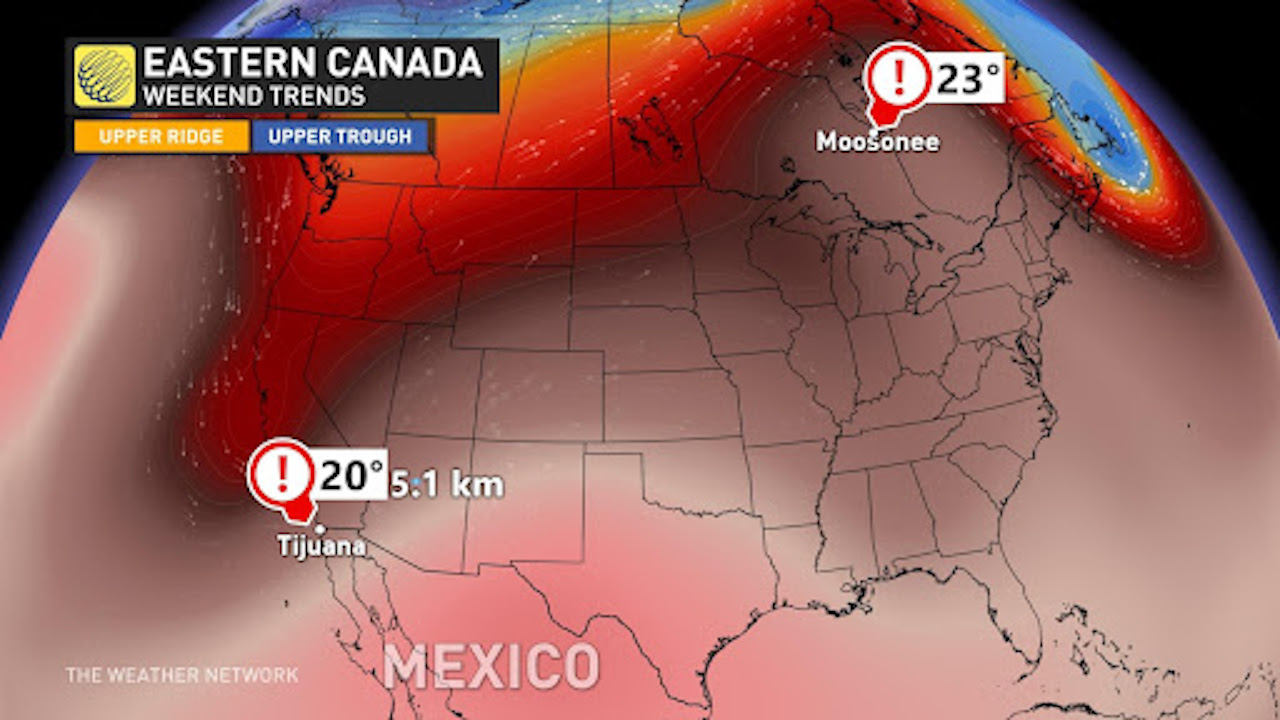
Moosonee (a town occasionally visited by polar bears) is forecast to be warmer than Tijuana this Friday. That would not be so unusual in mid-summer, but definitely quite a rare occurrence for Oct 8.
Meanwhile, it looks like I won't be getting my first night of <10C temps until second half of October this year. Most areas a bit inland from me have an average first frost date of October 15 or so.
Not much rain around here. Some maybe slightly above normal for the period but nothing to really put a major dent in this drought
It's good the the mountains out west will see snow. That will hopefully help refill some river basins down the road.
GFS certainly agreeing with the Euro in the 6-10 day
the positive anomalies are not quite as pronounced in the 11-15 day. To me that signals a pattern change. Maybe a subtle one
but the CFSv2 isn't seeing it yet. However the CFS is seeing a warming western US which probably means a cool down coming for the east as we get closer to the end of October
Last edited by chicagogeorge; 10-06-2021 at 09:15 AM..
Hmm... While U.S. pattern is still quite warm modeling collectively trended marginally cooler in past 24 hours for 3rd week of October. Maybe a sign that models are going towards a cooler end of October?
Moosonee (a town occasionally visited by polar bears) is forecast to be warmer than Tijuana this Friday. That would not be so unusual in mid-summer, but definitely quite a rare occurrence for Oct 8.
Meanwhile, it looks like I won't be getting my first night of <10C temps until second half of October this year. Most areas a bit inland from me have an average first frost date of October 15 or so.
This is what Ive been saying. There are temps as high as +10°C at Ivujivik, Quebec, not far from Nunavut! It's weird.
Not much rain around here. Some maybe slightly above normal for the period but nothing to really put a major dent in this drought
It's good the the mountains out west will see snow. That will hopefully help refill some river basins down the road.
GFS certainly agreeing with the Euro in the 6-10 day
the positive anomalies are not quite as pronounced in the 11-15 day. To me that signals a pattern change. Maybe a subtle one
but the CFSv2 isn't seeing it yet. However the CFS is seeing a warming western US which probably means a cool down coming for the east as we get closer to the end of October
It's so dry at my house it is like dust. Gonna be the driest next 9 months ever for my area.
Hmm... While U.S. pattern is still quite warm modeling collectively trended marginally cooler in past 24 hours for 3rd week of October. Maybe a sign that models are going towards a cooler end of October?
Early fall aswell as early spring are the most unstable periods of the year, when the medium-term patterns use to change alot, so calmdown and just wait to see how it goes george
That's true. At least for the next 10 days it will be well above normal here. Just take a loot at the temps this morning. It's 67 degrees at the airports right now. Normal low at ORD is 49F and at Midway it's 50F. The normal high for today is 68F at both airports. My normal low being in the outlying area is 46F and normal high is 70F for October 7th
Stormy today but up to the mid 80s by the weekend?
Scattered showers and thunderstorms around right now
Please register to post and access all features of our very popular forum. It is free and quick. Over $68,000 in prizes has already been given out to active posters on our forum. Additional giveaways are planned.
Detailed information about all U.S. cities, counties, and zip codes on our site: City-data.com.

 Please register to participate in our discussions with 2 million other members - it's free and quick! Some forums can only be seen by registered members. After you create your account, you'll be able to customize options and access all our 15,000 new posts/day with fewer ads.