Please register to participate in our discussions with 2 million other members - it's free and quick! Some forums can only be seen by registered members. After you create your account, you'll be able to customize options and access all our 15,000 new posts/day with fewer ads.
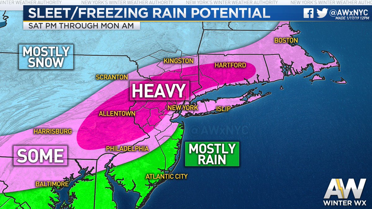
The ice map. Not looking forward to this. Its harder to measure because the changeover will compact the snow and not give you the actual total that fell..
Best I can say is measure every hour and Do not fall asleep Saturday night! lol If you measure Sunday morning you'll have false snow totals.
The ice map. Not looking forward to this. Its harder to measure because the changeover will compact the snow and not give you the actual total that fell..
Best I can say is measure every hour and Do not fall asleep Saturday night! lol
Yeah, that is one I saw, Weather channel thinks it will be mostly a snow event for us.......as of this second. They have been trending us in that direction for the last 24 hours or so.
there's going to be a ton of ignorant people whining "why are forecasters so terrible? Weatherman doesn't know anything"
Quote:
Originally Posted by Cambium
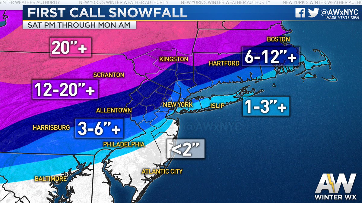
Yup. High "Bust" talk potential. Little shift in storm track or front speed will make or break the forecast. An area that is forecasted to get 6" of snow with ice and rain could easily be 12" of snow and sleet or 2" of snow and rain.
Now you know why I feel bad and give credit to forecasters. Lord bless them for what they do.
Reminds me of a system a few years ago. Overall timing was spot on. Highest snow amounts were spot on. Size of the area impacted was spot on. Only difference between the forecast was the location of the low itself was closer to the coast than anticipated. Instead of Manhattan getting 1.5 to 2 feet of snow, it received just a few inches. Areas to the north and northeast got that 1.5+ feet of snow, but people didn't pay attention to that.
I don't envy the forecasters on this one. Large area of mix/ice. The lines between snow and mix/ice and rain are all right along the major cities which means just a small shift in precip types and amounts will be magnified by the high population claiming a terrible forecast.
Yeah, as with the November storm, the margins are very thin. A tiny shift south/east, and you have a disaster in the most populated area of the country
Even the stingy weather channel (always low ball forecast for me) is saying 2 to 4" today and tonight, 3 to 5" Saturday and 8 to 12" Saturday night on top of the 3" I have... i could have 20" snow depth by sunday when my forecasted low is -5F.
Our forecast (I'm in SW New Hampshire, just outside of Keene) now says "more than a foot" on Saturday night followed by "more than a foot" on Sunday. Our snow totals keep going UP!
At least as of now there is no more mention of ice, and we are quite a bit north of that "ice band" in post #71. (We're in the "2 ft +" snow band!)
I won't mind the snow, I just don't want to lose power!! I did have 2 propane heaters installed this past fall just for such occasions, one upstairs (back hall) and one downstairs (TV room), so we would have SOME heat, but given the insanely low overnight temps expected Sunday night (negative numbers), I am more worried than excited at this point ...
Even the stingy weather channel (always low ball forecast for me) is saying 2 to 4" today and tonight, 3 to 5" Saturday and 8 to 12" Saturday night on top of the 3" I have... i could have 20" snow depth by sunday when my forecasted low is -5F.
Ned stark did say winter was coming lol.
Euro12z Data
Pittsburgh: 1.45" qpf and look at that! Not bad! Might end up being all snow.
It's that sliver of warmth coming over the top which can mess things up Saturday evening for you...
1.45" all snow at 10:1 ratios = 14-15"
NYC: 1.54". Did this change. Looks like mostly rain to me. Yikes! Surface and 5000' temps above freezing majority of event!
Providence: 2.33" qpf!. About 1" falls as all snow at first then that warm layer aloft moves in and ruins it all. Sleet, Ice mix.
A nice reminder why the changeover happens. It will start as snow and then that warm air aloft will come in. Depending how thick that above freezing air is will determine if its sleet or ice at surface.
Please register to post and access all features of our very popular forum. It is free and quick. Over $68,000 in prizes has already been given out to active posters on our forum. Additional giveaways are planned.
Detailed information about all U.S. cities, counties, and zip codes on our site: City-data.com.

 Please register to participate in our discussions with 2 million other members - it's free and quick! Some forums can only be seen by registered members. After you create your account, you'll be able to customize options and access all our 15,000 new posts/day with fewer ads.


 If you measure Sunday morning you'll have false snow totals.