Welcome to City-Data.com Forum!
U.S. CitiesCity-Data Forum Index
Go Back   City-Data Forum > General Forums > Weather
 [Register]
Please register to participate in our discussions with 2 million other members - it's free and quick! Some forums can only be seen by registered members. After you create your account, you'll be able to customize options and access all our 15,000 new posts/day with fewer ads.
View detailed profile (Advanced) or search
site with Google Custom Search

Search Forums  (Advanced)
 
Old 01-02-2016, 08:20 PM
 
29,556 posts, read 19,666,897 times
Reputation: 4563

Advertisements

Quote:
Originally Posted by Infamous92 View Post
Lol there's no way that'll verify.
Well maybe not for Atlanta, but that forecast certainly can and has happened in Chicago
Reply With Quote Quick reply to this message

 
Old 01-02-2016, 08:39 PM
 
51 posts, read 73,806 times
Reputation: 57
Quote:
Originally Posted by RAlex View Post
Brownsville, Texas at 3 PM! 25.91 N and elevation 23 ft.
That was pretty strange; Houston right now this night is warmer than that:
Attachment 163770

Although Brownsville is still at the same temp at this time:
Attachment 163771

Quote:
Originally Posted by muslim12 View Post
At 25 degrees north it should be tropical. But not only is it not tropical it is colder than many other subtropical locations. Crazy us weather.
The tropical latitudes start at 23.5 N/S of the equator, so tropical climates above those latitudes are exceedingly warm.

Quote:
Originally Posted by alex985 View Post
Yet here at the same latitude but on the wrong side of the Gulf, a day like this would be extraordinary.
The Texas Coast can get periods of heavy cloud cover during winter, which can keep daytime highs cool, like what you see, but at night, those same clouds still present prevent lows from bottoming out. Look at how in Texas and Louisiana, USDA zone 9 extends quite far inland, while such zones are confined to the coast in the states further east (except Florida):
http://davesgarden.com/zone/usda_hardiness_640.gif
Reply With Quote Quick reply to this message
 
Old 01-02-2016, 08:56 PM
 
Location: Westminster/Huntington Beach, CA
1,780 posts, read 1,765,533 times
Reputation: 1218
Default Finally!

Ahhhh...Finally we get to see some substantial rainfall out here in SoCal. Not to mention snow in our local mountains too! (And quite possibly a lot)

NWS 7-Day Total:


7-Day Totals


Reply With Quote Quick reply to this message
 
Old 01-02-2016, 10:05 PM
 
29,556 posts, read 19,666,897 times
Reputation: 4563
Gfs is now showing Arctic bullseye right over Chicagoland


https://twitter.com/BigJoeBastardi/s...12651540905985
Reply With Quote Quick reply to this message
 
Old 01-02-2016, 10:08 PM
 
29,556 posts, read 19,666,897 times
Reputation: 4563
https://twitter.com/Met_mdclark/stat...08614145835008
Reply With Quote Quick reply to this message
 
Old 01-03-2016, 05:28 AM
 
Location: Estonia
1,759 posts, read 1,881,464 times
Reputation: 1109
It's been heavily snowing all day after a stretch of -18°C days. So beautiful, better late than never.
Reply With Quote Quick reply to this message
 
Old 01-03-2016, 06:17 AM
 
Location: Near the Coast SWCT
83,564 posts, read 75,484,590 times
Reputation: 16634
A look at the current temps at 850mb around the Globe and who's reporting what. Lots of locations is snow falling in East Canada and Central Europe. You can be assured where those pinks and whites are it's pretty darn cold.


Reply With Quote Quick reply to this message
 
Old 01-03-2016, 06:46 AM
 
Location: Near the Coast SWCT
83,564 posts, read 75,484,590 times
Reputation: 16634
Coldest night and day of the season coming up. Here are the NWS Forecast lows for Tuesday morning


http://www.erh.noaa.gov/gis/images/SE_mint_Day2.png

http://www.erh.noaa.gov/gis/images/PHI_mint_Day2.png
Reply With Quote Quick reply to this message
 
Old 01-03-2016, 07:26 AM
 
Location: New Jersey
15,318 posts, read 17,241,383 times
Reputation: 6959
Quote:
Originally Posted by NativeOrange View Post
Ahhhh...Finally we get to see some substantial rainfall out here in SoCal. Not to mention snow in our local mountains too! (And quite possibly a lot)

NWS 7-Day Total:


7-Day Totals


This should be very beneficial for California, though flooding might be an issue. Hopefully it'll be more of a slow, steady soaking rain.

Current US Drought Monitor:


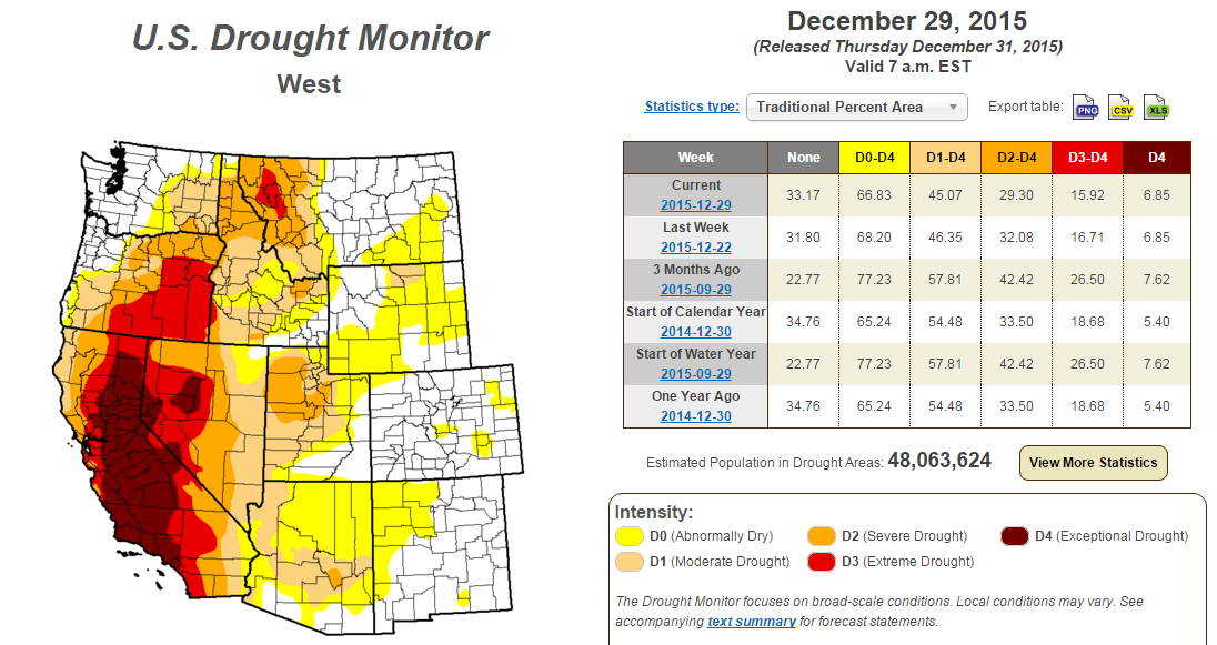
^ Some subtle improvements this week compared to last week.

Here's a good summary from NWS Los Angeles about the upcoming week:

...A SERIES OF STORMS TO AFFECT SOUTHWESTERN CALIFORNIA MUCH OF
NEXT WEEK...


...TIME TO PREPARE FOR POTENTIAL FLOODING AND DEBRIS FLOWS FROM
RECENT BURN AREAS...

A SERIES OF STORM SYSTEMS ARE LINING UP ACROSS THE PACIFIC OCEAN
AND WILL AFFECT SOUTHWEST CALIFORNIA THROUGH NEXT WEEK. THE FIRST
STORM IS EXPECTED TO BRING A THREAT OF RAIN TO THE CENTRAL COAST
BY SUNDAY AFTERNOON...SPREADING SOUTH OF POINT CONCEPTION ON
SUNDAY NIGHT. THE CHANCE OF RAIN AND MOUNTAIN SNOW WILL LIKELY
PERSIST ACROSS THE ENTIRE FORECAST AREA INTO MONDAY. THERE IS
STILL SOME UNCERTAINTY ON RAINFALL AMOUNTS WITH THIS FIRST
SYSTEM...BUT MOST AREAS SHOULD SEE BETWEEN ONE QUARTER AND THREE
QUARTERS OF AN INCH. MOUNTAIN RESORTS ABOVE 6000 FEET COULD SEE 2
TO 4 INCHES OF SNOW WITH THIS FIRST SYSTEM.


THE SECOND STORM ON TUESDAY IS FORECASTED TO BE STRONGER WITH
MORE SOUTHERLY FLOW THAT WILL HELP TO ENHANCE RAINFALL

TOTALS...ESPECIALLY ACROSS SOUTH FACING MOUNTAINS AND FOOTHILLS.
COASTAL AND VALLEY AREAS CAN GENERALLY EXPECT BETWEEN ONE AND TWO
INCHES OF RAIN WITH THIS SYSTEM...WITH TWO TO FOUR INCHES POSSIBLE
IN THE FOOTHILLS AND MOUNTAINS.
DUE TO THE POTENTIAL FOR RAINFALL
RATES BRIEFLY REACHING ONE HALF INCH PER HOUR...RECENT BURN
AREAS...INCLUDING THE SOLIMAR BURN AREA...WILL BE AT RISK FOR
FLASH FLOODING WITH MUD AND DEBRIS FLOWS. SNOW LEVELS WITH THIS
SECOND STORM ARE GENERALLY EXPECTED TO RANGE BETWEEN 6000 AND 7000
FEET. THERE IS THE POTENTIAL FOR SIGNIFICANT SNOW WITH 1 TO 2 FOOT
ACCUMULATIONS POSSIBLE ABOVE 7000 FEET...AND LESSER AMOUNTS DOWN
TO 6000 FEET.
DUE TO THE POTENTIAL FOR HEAVY SNOW AND STRONG
SOUTHERLY WINDS...A WINTER STORM WATCH WILL NEED TO BE CONSIDERED
FOR THIS STORM AS WE DRAW CLOSER TO THE EVENT.

PERIODS OF ADDITIONAL RAIN AND MOUNTAIN SNOW WILL BE LIKELY
WEDNESDAY THROUGH FRIDAY. THESE SYSTEMS WILL HAVE THE POTENTIAL
TO BE COLDER...WITH SNOW LEVELS FALLING AS LOW AS 4000 FEET.
THE
LOWER SNOW LEVELS COULD RESULT IN MORE WIDESPREAD SNOW IMPACTS
ACROSS THE LOCAL MOUNTAINS...INCLUDING INTERSTATE 5 NEAR THE
GRAPEVINE. THERE IS STILL SOME UNCERTAINTY IN THE EXACT TIMING
AND TRACK OF THESE SYSTEMS LATER IN THE WEEK...HOWEVER THE
POTENTIAL EXISTS FOR BRIEF HEAVY DOWNPOURS AND ISOLATED
THUNDERSTORMS.

ON TOP OF THE RAIN AND SNOW...THERE WILL BE HIGH SURF CONDITIONS
MUCH OF NEXT WEEK...POTENTIALLY REACHING DAMAGING LEVELS BY
WEDNESDAY OR THURSDAY. THE COMBINATION OF HIGH SURF...GUSTY
WINDS...PERIODS OF RAIN...AND HIGH TIDES WILL BRING THE POTENTIAL
FOR SOME COASTAL FLOODING BY MIDWEEK. FOR MORE DETAILS ON HIGH SURF
AND COASTAL FLOODING...PLEASE REFER TO THE LATEST COASTAL HAZARD
MESSAGE.

http://forecast.weather.gov/showsigw...7#.Vokt2vkrLIU
Reply With Quote Quick reply to this message
 
Old 01-03-2016, 07:41 AM
 
29,556 posts, read 19,666,897 times
Reputation: 4563
I usually dislike Lake Michigan's influence, especially in the summer where shoreline and city proper can see daytime temperatures impacted by keeping them down, and night time temperature up. I almost never get it's influence being 35+ miles away, though lake breezes have been known to travel 40 miles inland during the spring. On the other hand, I usually miss out on lake effect snow (though not always).


Here are the minimums at Northerly Island, on the lake in downtown Chicago, so that station has a combo if lake and UHI influence. MDW which is 9 miles inland so it has less of a lake influence but a strong UHI, ORD which 12 miles away from the lake and more of a suburban heat island, and the Kankakee station which is 5 miles south of where I live, and over 40 miles from the lakeshore. I would say it's definitely a rural or exurban influence station.

July 2012, Northerly Island had a minimum of 75F . That's 6 degrees warmer than I did, and about the same in January 2014. Even at just 12 miles away, Northerly Island was 4 degrees warmer than ORD in July 2012, and January 2014. Incidentally, I looked at LGA NYC, which is also a strong UHI and water influenced station, and the highest average minimum I could find was July 2010 at 74.9F.


Is the GFS always the last at the Arctic air party?


https://twitter.com/BigJoeBastardi/s...23258415616000

Last edited by chicagogeorge; 01-03-2016 at 08:02 AM..
Reply With Quote Quick reply to this message
Please register to post and access all features of our very popular forum. It is free and quick. Over $68,000 in prizes has already been given out to active posters on our forum. Additional giveaways are planned.

Detailed information about all U.S. cities, counties, and zip codes on our site: City-data.com.


Reply
Please update this thread with any new information or opinions. This open thread is still read by thousands of people, so we encourage all additional points of view.

Quick Reply
Message:


Over $104,000 in prizes was already given out to active posters on our forum and additional giveaways are planned!

Go Back   City-Data Forum > General Forums > Weather

All times are GMT -6.

© 2005-2024, Advameg, Inc. · Please obey Forum Rules · Terms of Use and Privacy Policy · Bug Bounty

City-Data.com - Contact Us - Archive 1, 2, 3, 4, 5, 6, 7, 8, 9, 10, 11, 12, 13, 14, 15, 16, 17, 18, 19, 20, 21, 22, 23, 24, 25, 26, 27, 28, 29, 30, 31, 32, 33, 34, 35, 36, 37 - Top