Welcome to City-Data.com Forum!
U.S. CitiesCity-Data Forum Index
Go Back   City-Data Forum > General Forums > Weather
 [Register]
Please register to participate in our discussions with 2 million other members - it's free and quick! Some forums can only be seen by registered members. After you create your account, you'll be able to customize options and access all our 15,000 new posts/day with fewer ads.
View detailed profile (Advanced) or search
site with Google Custom Search

Search Forums  (Advanced)
 
Old 05-17-2015, 05:09 AM
 
Location: Near the Coast SWCT
83,694 posts, read 76,068,519 times
Reputation: 16713

Advertisements

Quote:
Originally Posted by nei View Post
I'm confused, the NWS is forecasting a high of 80°F, weather underground 87°F. Which is it? This is a really big gap for a same day forecast, and the front past.
I still say W.U will be wrong. We'll see. Get that sun shining early on and maybe you come close?

Sorry for repeating but this still looks like the warmest day till June so enjoy it. Actually models showing just 1 day similar next week but overall we wont get this warm again for couple weeks..

Reply With Quote Quick reply to this message

 
Old 05-17-2015, 05:19 AM
 
Location: Near the Coast SWCT
83,694 posts, read 76,068,519 times
Reputation: 16713
Euro Data for Danbury, CT. I'm in love with the area I boxed out. Temps are good too. Looks like little clouds, so will be Sunny and dry with 60s.

SouthEast ridge tries to rebuild again and you can see we might warm up from Memorial day onwards. Still too far.

Reply With Quote Quick reply to this message
 
Old 05-17-2015, 05:42 AM
nei nei won $500 in our forum's Most Engaging Poster Contest - Thirteenth Edition (Jan-Feb 2015). 

Over $104,000 in prizes has already been given out to active posters on our forum and additional contests are planned
 
Location: Western Massachusetts
45,983 posts, read 53,760,207 times
Reputation: 15184
Quote:
Originally Posted by Cambium View Post
I still say W.U will be wrong. We'll see. Get that sun shining early on and maybe you come close?

Sorry for repeating but this still looks like the warmest day till June so enjoy it. Actually models showing just 1 day similar next week but overall we wont get this warm again for couple weeks..
I was thinking of avoiding it. Was considering doing a long bike ride today, 87°F sounds hotter than I like, 80°F sounds tolerable. It's not humid at least, but it's May. There are plenty other friendlier temperature days. And not as used to doing stuff in the heat as I would be in July. Thinking of going, and if the heat bothers me, I can shorten the ride.

Lots like it could be hot from the sky, not sure if it's possible to judge accurately.
Reply With Quote Quick reply to this message
 
Old 05-17-2015, 06:11 AM
 
Location: New Jersey
15,318 posts, read 17,291,664 times
Reputation: 6959
Had two big thunderstorms roll through last night. Got a much needed soaking. Everything is still wet outside. Currently 68 F/20 C with a dewpoint of 64 F/18 C (87%).
Reply With Quote Quick reply to this message
 
Old 05-17-2015, 07:03 AM
 
Location: New Jersey
15,318 posts, read 17,291,664 times
Reputation: 6959
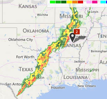
Flood watches and warnings in Arkansas and Texas. Heavy line of rain in Texas, SE Oklahoma, and Arkansas.


Winter Weather Advisories in North Dakota. Right now it's in the 50s and 60s F:

URGENT - WINTER WEATHER MESSAGE
NATIONAL WEATHER SERVICE BISMARCK ND
445 AM CDT SUN MAY 17 2015

...WINTER WEATHER ADVISORY FOR SNOW ACCUMULATIONS OVER MUCH OF
NORTH CENTRAL NORTH DAKOTA TONIGHT...

.RAIN IS EXPECTED TO CHANGE OVER TO SNOW LATE THIS AFTERNOON OVER
NORTHWESTERN AND NORTH CENTRAL NORTH DAKOTA. SNOW SHOULD BEGIN
ACCUMULATING EARLY THIS EVENING AND CONTINUE THROUGH TONIGHT. SNOW
ACCUMULATIONS OF 3 TO 5 INCHES CAN BE EXPECTED ALONG AND NORTHEAST
OF A LINE FROM STANLEY AND KENMARE...TO GARRISON AND HARVEY AND
CARRINGTON. SOME AREAS IN THE TURTLE MOUNTAINS MAY RECEIVE HIGHER
AMOUNTS.

IN ADDITION TO THE SNOW...STRONG NORTH WINDS OF 25 TO 35 MPH ARE
EXPECTED. THIS WILL CREATE ADDITIONAL TRAVEL PROBLEMS AND WILL
INCREASE THE THREAT TO LIVESTOCK.

PEOPLE PLANNING TRAVEL ACROSS NORTH CENTRAL NORTH DAKOTA SHOULD
ALLOW EXTRA TIME TO REACH YOUR DESTINATION. SLOW DOWN AND ALLOW
EXTRA STOPPING TIME. THE NORTH DAKOTA HIGHWAY PATROL ADVISES NOT
USING YOUR CRUISE CONTROL WHILE DRIVING IN SNOW COVERED OR ICY
ROADS.
Reply With Quote Quick reply to this message
 
Old 05-17-2015, 08:13 AM
nei nei won $500 in our forum's Most Engaging Poster Contest - Thirteenth Edition (Jan-Feb 2015). 

Over $104,000 in prizes has already been given out to active posters on our forum and additional contests are planned
 
Location: Western Massachusetts
45,983 posts, read 53,760,207 times
Reputation: 15184
75°F at 10 am. High of 80°F? Don't think so. Heat is coming!
Reply With Quote Quick reply to this message
 
Old 05-17-2015, 08:23 AM
 
Location: Near the Coast SWCT
83,694 posts, read 76,068,519 times
Reputation: 16713
Quote:
Originally Posted by nei View Post
75°F at 10 am. High of 80°F? Don't think so. Heat is coming!
Told you, the sun.. Sun early & you had a better chance. Looking good to pass 80 but there's no 80s all the way down to Georgia right now so it's not like theres "extra" heat nearby to keep you pushing warmer. Low 80s looking good.

Went for a 3 mile run, my time is running out to keep doing that. lol. Between muddy trails in the jungle, bugs, and humidity it wasn't pleasurable.


Quote:
Originally Posted by ilovemycomputer90 View Post

URGENT - WINTER WEATHER MESSAGE
NATIONAL WEATHER SERVICE BISMARCK ND
445 AM CDT SUN MAY 17 2015

...WINTER WEATHER ADVISORY FOR SNOW ACCUMULATIONS OVER MUCH OF
NORTH CENTRAL NORTH DAKOTA TONIGHT...

.RAIN IS EXPECTED TO CHANGE OVER TO SNOW LATE THIS AFTERNOON OVER
NORTHWESTERN AND NORTH CENTRAL NORTH DAKOTA. SNOW SHOULD BEGIN
ACCUMULATING EARLY THIS EVENING AND CONTINUE THROUGH TONIGHT. SNOW
ACCUMULATIONS OF 3 TO 5 INCHES CAN BE EXPECTED ALONG AND NORTHEAST
Awesome! Man I wish that was here. I see why now.. 850mb freezing line digging down and swinging around. I bet you that air mass is why we stay cool here Wed-Sat.

Reply With Quote Quick reply to this message
 
Old 05-17-2015, 08:24 AM
 
1,011 posts, read 719,019 times
Reputation: 292
A selection of charts to see out the second half of May in the UK.

19th: We see low pressure and cool air over the UK with some unsettled conditions.


26th: High pressure is closer, but remains to the west, dragging the same tongue of cold northerlies over the UK ad infinitum.


31st: The UK remains lodged between HP out west and LP developing to the east, keeping a chilly northerly flow channeled directly over the UK.

Reply With Quote Quick reply to this message
 
Old 05-17-2015, 08:29 AM
 
Location: New York
11,326 posts, read 20,407,569 times
Reputation: 6231
77F, partly cloudy, DP of 68F = perfect morning weather.
Reply With Quote Quick reply to this message
 
Old 05-17-2015, 08:35 AM
B87
 
Location: Surrey/London
11,769 posts, read 10,656,453 times
Reputation: 3099
Summer 1996, after the horrific May, the coldest on record at Heathrow. June 1996 was warm, with an average July and August. It's not all doom and gloom with the rubbish May we are currently having.

June: Climate Londres / Heathrow Airport (June 1996) - Climate data (37720)
July: Climate Londres / Heathrow Airport (July 1996) - Climate data (37720)
August: Climate Londres / Heathrow Airport (August 1996) - Climate data (37720)
Reply With Quote Quick reply to this message
Please register to post and access all features of our very popular forum. It is free and quick. Over $68,000 in prizes has already been given out to active posters on our forum. Additional giveaways are planned.

Detailed information about all U.S. cities, counties, and zip codes on our site: City-data.com.


Reply
Please update this thread with any new information or opinions. This open thread is still read by thousands of people, so we encourage all additional points of view.

Quick Reply
Message:

Over $104,000 in prizes was already given out to active posters on our forum and additional giveaways are planned!

Go Back   City-Data Forum > General Forums > Weather

All times are GMT -6.

© 2005-2024, Advameg, Inc. · Please obey Forum Rules · Terms of Use and Privacy Policy · Bug Bounty

City-Data.com - Contact Us - Archive 1, 2, 3, 4, 5, 6, 7, 8, 9, 10, 11, 12, 13, 14, 15, 16, 17, 18, 19, 20, 21, 22, 23, 24, 25, 26, 27, 28, 29, 30, 31, 32, 33, 34, 35, 36, 37 - Top