Please register to participate in our discussions with 2 million other members - it's free and quick! Some forums can only be seen by registered members. After you create your account, you'll be able to customize options and access all our 15,000 new posts/day with fewer ads.
That looks a bit like Ashdown Forest in Sussex, with regards to the UK I find the vegetation changes from the SE to the SW, the vegetation in Cornwall can be a bit 'sub-tropical' looking (thanks to the incredibly mild winters brought courtesy of the Gulf Stream rather than summer heat) in some ways it doesn't look like it belongs in this part of Europe.
Hi people, the vegetation in a specific area between the cities of Béziers and of Perpignan (ie the coastal part of *southern Languedoc* + including roughly 20 km / *or 12 miles* inland), looks like one of the most arid ones in France. And is in fact, indeed, climatically one of the most arid parts of the country (along with the area around the city of Marseille, in another region, *Provence*).
It's a rather small area, of less than 1000 km² (less than 390 sq mi), centered on the towns / villages of Leucate, La Palme and Fitou (in the southern part of the Aude department) and Opoul-Périllos, Salses-le-Château and Tautavel (in the northern part of the Pyrénées-Orientales department).
This area is the wind zone of the Tramontane, which very often and strongly blows from the North-West, between the Pyrenean range to the south and the Massif Central range to the north. This wind is kind of accelerated around the "seuil du Lauragais" ("threshold"? of the Lauragais), located between Toulouse and Carcassonne.
It's very characteristic and it helps give the somewhat semi-arid look of this region, along with the (sometimes) very strong autumn/fall (thunderstormy) rainfalls, which also leach the region's soil (the rainfalls being extremely intense within a small amount of time, at times). Add lengthy periods of strong sunshine (with wind!) in summer, and with these three elements, you get the Mediterranean climate of Leucate.
About 330 mm of precipitation fall in one year on average (new official time frame: 1991-2020 / ...giving the fact that you only have data from 2000 to 2020 by following this link, it must be precised!).
The illustrating pictures found on the net, in spoilers just below, are from this area:
The last collage of six pictures shows Leucate and its added vegetation, that normally doesn't grow naturally over there (for example, the Washingtonia palms, introduced there from California):
Spoiler
Spoiler
Those photos look clearly mediterranean. Another further proof that any climate can be identified largely by the vegetation/environment.
Here are some photos from the subarctic climate proper from sea level to altitude.
This is from northern Norway more than 200 km inside the Arctic Circle.
All images are mine, from summer.
Sea level, near a fjord:
This is at 160 m ASL/500 ft. This area is grazed by cattle and sheep, therefore some open areas with gras, flowers and som junipers. Otherwise the subarctic birch (and aspen, rowan, pine) forest would be dense.
Now at 250 m ASL / 800 ft, the trees are getting smaller and lots of open wet areas/bogs.
And finally up on the alpine tundra at nearly 600 m / 1900 ft:
Yeah, that's right. Taiga forests look like a weak or "sick" version of a temperate mixed forest. It's a distinctive feature of them.
And they also are, as shown in your photos, very bright and crisp under sun exposure creating a sharp contrast with the background terrain, something that doesn't happen with the case of a temperate forest, wich looks more deep, like a impressionist painting in comparison.
IMO, taiga forests look very 'healthy' and beautiful. Jakobsli's photos of the "taiga zone" looked more tundra-like I believe. Heck, I would say temperate forests are 'overdone' and cloying to look at. Like, they're too much sugar in a nice cake, if you know what I mean. But yeah, I think taigas look decent and attractive enough. I'm guessing the conifer trees really help amplify their beauty.
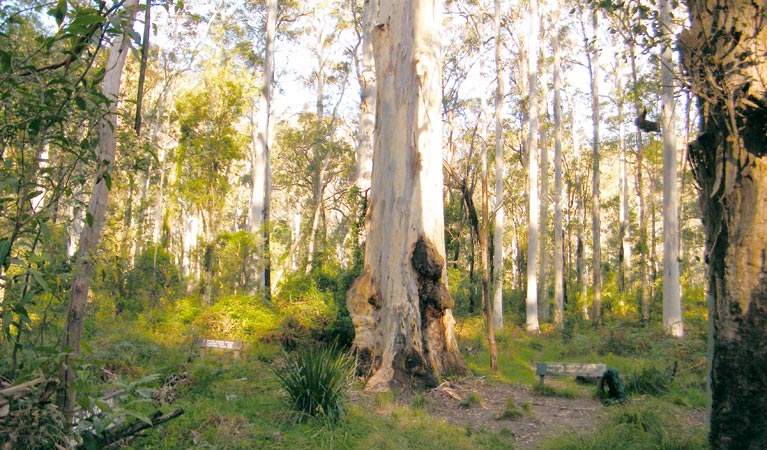
A weak or "sick" version of a temperate forest would be those dry eucalyptus forests here in eastern Australia (some may argue that they're more "Mediterranean" in essence, even though they're listed under "eastern Australian temperate forests", so whichever you prefer):
IMO, taiga forests look very 'healthy' and beautiful. Jakobsli's photos of the "taiga zone" looked more tundra-like I believe. Heck, I would say temperate forests are 'overdone' and cloying to look at. Like, they're too much sugar in a nice cake, if you know what I mean. But yeah, I think taigas look decent and attractive enough. I'm guessing the conifer trees really help amplify their beauty.
A weak or "sick" version of a temperate forest would be those dry eucalyptus forests here in eastern Australia (some may argue that they're more "Mediterranean" in essence, even though they're listed under "eastern Australian temperate forests", so whichever you prefer):
They make the taiga look like the African jungle.
No, this is how the tundra look like - no trees at all, at most bushes (0.5 m ~ 1.5 m tall) near the treeline:
The summer climate in the boreal forest/taiga can be identified by vegetation. The limiting factor there is summer warmth (although it can locally be nutritients, moisture or freezing lows in growth season). Here is a boreal forest near a river (inland & 200 km north of Trondheim), summer has three months with mean above 10C (July avg high ~ 20C, + one month with mean nearly 9C), many trees are > 20-25 m tall. Compare with image in my previous post at 250 m ASL inside Arctic Circle, where mean > 10C is like 5-6 weeks and avg high in July is ~ 15C.
That looks differente, hemiboreal at least. So I expect it to have an anual mean above 0ºC to begin with, and in correlation with my system's treholds.
That looks differente, hemiboreal at least. So I expect it to have an anual mean above 0ºC to begin with, and in correlation with my system's treholds.
All forest-image locations in my two posts here have annual mean above 0C. The two tundra locations should have annual mean slightly below 0C.
No, this is how the tundra look like - no trees at all, at most bushes (0.5 m ~ 1.5 m tall) near the treeline:
I know that tundra looks desolate. I know the difference between taiga and tundra.
Please register to post and access all features of our very popular forum. It is free and quick. Over $68,000 in prizes has already been given out to active posters on our forum. Additional giveaways are planned.
Detailed information about all U.S. cities, counties, and zip codes on our site: City-data.com.

 Please register to participate in our discussions with 2 million other members - it's free and quick! Some forums can only be seen by registered members. After you create your account, you'll be able to customize options and access all our 15,000 new posts/day with fewer ads.


 the vegetation in a specific area between the cities of Béziers and of Perpignan (ie the coastal part of *southern Languedoc* + including roughly 20 km / *or 12 miles* inland), looks like one of the most arid ones in France. And is in fact, indeed, climatically one of the most arid parts of the country (along with the area around the city of Marseille, in another region, *Provence*).