Spring 2012 Thread (March-May) (temp, London, daily, temps)
Please register to participate in our discussions with 2 million other members - it's free and quick! Some forums can only be seen by registered members. After you create your account, you'll be able to customize options and access all our 15,000 new posts/day with fewer ads.
You can see how New England has been buffered from the strongest effects of the heat wave; 7°F above normal, about the same as all of February. Still, there's more to come.
How unprecedented is the current warm spell? One has to go all the way into the month of April to find a stretch of warmth that compares:
# of consecutive 70 degree days..Dates....................Year
9 days.............................................. April 16-24..............1886
6 days and counting (as of 3/19/12)....March 14-March 19..2012
In other words, one has to go back over 125 years to find an early-season warm spell that compares, and even that streak occurred in April, a full month later. Needless to say, this stretch of 6 consecutive 70 degree days already represents a new March record for both Detroit and Flint, while it ties the record for Saginaw. Several more days of 70 degree temperatures are forecast.
It looks like a given that we'll be tying the April heat wave. Forecasted highs of 82 tomorrow, 83 Wednesday, and 79 on Thursday.
You can see how New England has been buffered from the strongest effects of the heat wave; 7°F above normal, about the same as all of February. Still, there's more to come.
I've never seen the scale that off the charts. A similar chart for the Midwest would be interesting.
Keep these graphics/stats coming! Am wondering, are the lows as abnormally warm as the highs? Last April, one of the statistically most abnormally warm months on record here, the highs were 6C/11F above normal but because of the clear night skies the lows only 3.6C/7F above so the overall anomaly wasn't quite as impressive.
After this spell of above average temperatures in the UK the outlook for early April is for high pressure building west bringing North/North Westerly winds, and the typical cloud, drizzle and stinging winds that comes with this set up. From one boring weather setup to a colder and even more boring one. Joy. To know exactly how much it will suck let's just take a look at early May 2010 which featured that pattern. It was more like January.
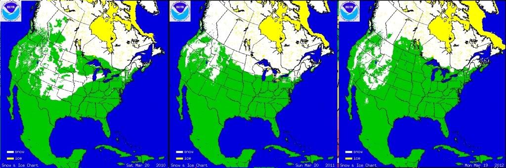
Whats with all the surprise about no snow cover after mid March??
Does anyone see a difference past 3 years with snow cover March 20th?
Do people think the entire map will be white this time of year?
2 Noticeable things with these. This years warmth Central and East. (no snow even into Canada) AND the West/Rockies/Sierra seem to be consistant.
Anything else?
The Rockies and Sierra normally get snow in March, and are usually close to their peak snow depth in March (peak is April 1st in the higher elevations of Yosemite); even a warm year will still have snow in high elevations. The highest elevations keep their snowpack well into June, and in the Cascades, occasionally into August. This link shows how it fluctuates at this Sierra Pass.
Keep these graphics/stats coming! Am wondering, are the lows as abnormally warm as the highs? Last April, one of the statistically most abnormally warm months on record here, the highs were 6C/11F above normal but because of the clear night skies the lows only 3.6C/7F above so the overall anomaly wasn't quite as impressive.
No, the highs are more out of range than the lows. Right now, the daily average is 48°F/26°F (changing fast this time of year!). Most days the last week the low was around the high 30s, while the highs could reach into the 70s. High yesterday was 79°F. Starting this morning the lows are higher 45°F, might reach 50°F; so 20-25°F above average but not the 30-35°F above average highs forecast. It's usual for the lows not to increase as much the highs, you need summer-like humidity levels for the lows to reach that high. 10°F above average lows for a stretch (like what we had in the upper 30s) isn't that unusual, since those mornings war cloudy; our pattern right now is cloud overnight then burns off if it gets hot.
But that's in New England. In the Midwest, some truly incredible night temperatures have been recorded. In Chicago, the overnight low was 66°F, midsummer levels. Look at the shift from cold to heat wave temperatures!
Please register to post and access all features of our very popular forum. It is free and quick. Over $68,000 in prizes has already been given out to active posters on our forum. Additional giveaways are planned.
Detailed information about all U.S. cities, counties, and zip codes on our site: City-data.com.

 Please register to participate in our discussions with 2 million other members - it's free and quick! Some forums can only be seen by registered members. After you create your account, you'll be able to customize options and access all our 15,000 new posts/day with fewer ads.