Please register to participate in our discussions with 2 million other members - it's free and quick! Some forums can only be seen by registered members. After you create your account, you'll be able to customize options and access all our 15,000 new posts/day with fewer ads.
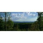
Really, the only way to get good views of the bridge is to hike the Glade Creek Trail. The lower (main) trail head is in the NRG and is about 5.6 miles from the bridge.
There is a upper trail head that is accessible on a high clearance required road off of Grandview Rd. towards Little Beaver SP from I-64. Its about 1/3 mile from the upper trail head to the bridge.
I wish there was an overlook, but it's difficult with the Interstate standards for controlled access. But it's close enough to the Grandview exit that an access road could work. Plus, with Grandview and Little Beaver nearby, it could tie into the park system nicely.
It is possible to do a overlook pull off. Virginia has several along I 64 going down Afton Mtn near Waynesboro.
It is possible to do a overlook pull off. Virginia has several along I 64 going down Afton Mtn near Waynesboro.
Then the DOT better get on it! There are plenty of people who drive on I-77 or I-64 and totally miss the New River Gorge Bridge. This would be the next best thing, I suppose. That, and an overlook where you start to come down I-77 after the split at Beckley and see the plateau open up (sort of like after you get into NC, only on a smaller scale). I can't remember where that spot is exactly, though.
Very timely thread for me - will be crossing this bridge once again later this summer! I agree that an overlook is very much needed and would be a very welcome addition to this beautiful place. I suppose it's too close to Tamarack to get a visitor's center with information about the area and in particular, about the New River Gorge and the construction of the bridge, but surely an overlook and perhaps a picnic area could be added. Perhaps funding is the problem just now...but why wasn't an overlook constructed when the bridge was built?
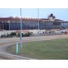
Also, in Jefferson County, WV is the recently completed Delta-Rahmen Bridge. It is on the new Rt. 9 that travels east/west from Charles Town to the Virginia state line. It opened on November 14, 2012. At 200 feet above the Shenandoah River, it is the largest Delta-Rahmen bridge in North-America. The term Delta-Rahmen means that the supports holding up the bridge are Y shaped (You can see this in the pictures below). There are very few bridges constructed with this format, and West Virginia now has the largest one in North America!
Construction pictures:
P.S. I'm not trying to change the subject of the thread from the original post. I'd just thought I'd share the Delta-Rahmen while we're on the topic of West Virginia bridges.
I just crossed this bridge twice over the weekend in my travels to Greenbrier County. I found myself wondering how high this bridge was because it seemed nearly as high as the New River Gorge Bridge on 119. Ironic I see this posted today.
I sure did Buttercup. We stayed with my brother and his wife in Lewisburg. Made the journey up 219 north to Beartown State Park. Had a great time up there. We also ventured over to Smooth Ambler distillery and sampled a few of their concoction's. Overall we had a great time and are already planning our next trip.
The eastern part of Corridor H/US Route 48 has some pretty spectacular bridges, as well.
Please register to post and access all features of our very popular forum. It is free and quick. Over $68,000 in prizes has already been given out to active posters on our forum. Additional giveaways are planned.
Detailed information about all U.S. cities, counties, and zip codes on our site: City-data.com.

 Please register to participate in our discussions with 2 million other members - it's free and quick! Some forums can only be seen by registered members. After you create your account, you'll be able to customize options and access all our 15,000 new posts/day with fewer ads.