West Grove, Pennsylvania

Submit your own pictures of this borough and show them to the world
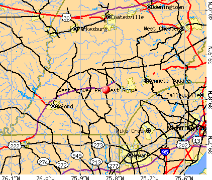
- OSM Map
- General Map
- Google Map
- MSN Map
Population change since 2000: +5.5%
 |
| Males: 1,178 | |
| Females: 1,620 |
| Median resident age: | 35.5 years |
| Pennsylvania median age: | 40.9 years |
Zip codes: 19390.
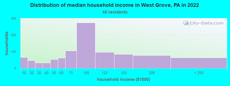
| West Grove: | $81,851 |
| PA: | $71,798 |
Estimated per capita income in 2022: $32,158 (it was $19,967 in 2000)
West Grove borough income, earnings, and wages data
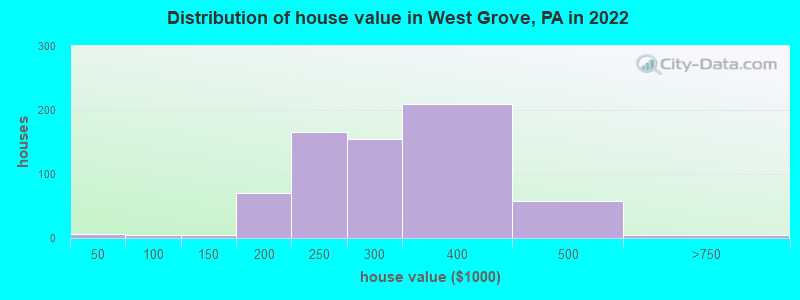
Estimated median house or condo value in 2022: $285,969 (it was $122,000 in 2000)
| West Grove: | $285,969 |
| PA: | $245,500 |
Mean prices in 2022: all housing units: $511,435; detached houses: $558,854; townhouses or other attached units: $385,338; in 2-unit structures: $427,369; in 3-to-4-unit structures: $339,843; in 5-or-more-unit structures: $283,216; mobile homes: $76,655
Median gross rent in 2022: $1,360.
(4.8% for White Non-Hispanic residents, 4.1% for Black residents, 23.6% for Hispanic or Latino residents, 28.2% for other race residents, 24.9% for two or more races residents)
Detailed information about poverty and poor residents in West Grove, PA


Compare current foreclosures near West Grove, PA:
| Photo | Address | Area | Beds / Baths | Price | Details |
|---|---|---|---|---|---|

|
#1
S Guernsey Rd
West Grove, PA 19390
|
2,400 sq. feet
|
3 baths 6 beds |
$283,973
|
show details |

|
#2
Briarcliff Cir
West Grove, PA 19390
|
3,423 sq. feet
|
2 baths 4 beds |
$337,610
|
show details |

|
#3
Blanca Ct
West Grove, PA 19390
|
4,300 sq. feet
|
2 baths 4 beds |
show details | |

|
#4
E Hillcrest Ave
West Grove, PA 19390
|
2,359 sq. feet
|
2 baths 3 beds |
show details | |

|
#5
English Ln
West Grove, PA 19390
|
2,552 sq. feet
|
2 baths 4 beds |
show details | |

|
#6
Woodcrest Rd
West Grove, PA 19390
|
2,907 sq. feet
|
3 baths 3 beds |
show details | |

|
#7
N Pine St
Wilmington, DE 19802
|
1,125 sq. feet
|
1 baths 3 beds |
$199,900
|
show details |

|
#8
W Bridge St
Parkesburg, PA 19365
|
1,056 sq. feet
|
1 baths 4 beds |
$327,500
|
show details |

|
#9
N Madison St Apt 106
Wilmington, DE 19801
|
1,000 sq. feet
|
2 baths 2 beds |
$159,900
|
show details |

|
#10
Schoolview Ln
Oxford, PA 19363
|
3,504 sq. feet
|
2 baths 4 beds |
$346,389
|
show details |
| Photo | Address | Area | Beds / Baths | Price | Details |
|---|---|---|---|---|---|

|
#11
Leeward St
Coatesville, PA 19320
|
1,746 sq. feet
|
2 baths 3 beds |
$274,728
|
show details |

|
#12
Barbara Dr
Downingtown, PA 19335
|
1,908 sq. feet
|
2 baths 4 beds |
$275,782
|
show details |

|
#13
Center Hall Rd
Cochranville, PA 19330
|
1,472 sq. feet
|
1 baths 3 beds |
$120,017
|
show details |

|
#14
Lamberts Ln
Coatesville, PA 19320
|
1,892 sq. feet
|
2 baths 4 beds |
$395,461
|
show details |

|
#15
Quill Ct
Oxford, PA 19363
|
2,454 sq. feet
|
2 baths 3 beds |
$291,550
|
show details |

|
#16
E Kings Hwy
Coatesville, PA 19320
|
1,504 sq. feet
|
2 baths 3 beds |
$194,489
|
show details |

|
#17
Oxford Rd
West Chester, PA 19380
|
2,116 sq. feet
|
2 baths 4 beds |
$173,254
|
show details |

|
#18
Mimosa Cir
Kennett Square, PA 19348
|
2,024 sq. feet
|
2 baths 3 beds |
$500,493
|
show details |

|
#19
Andrew Cir
Coatesville, PA 19320
|
1,536 sq. feet
|
1 baths 2 beds |
$125,834
|
show details |

|
#20
Grove Rd
West Chester, PA 19380
|
875 sq. feet
|
1 baths 3 beds |
$19,782
|
show details |
| Photo | Address | Area | Beds / Baths | Price | Details |
|---|---|---|---|---|---|

|
#21
Wagners Ln
Coatesville, PA 19320
|
2,910 sq. feet
|
2 baths 4 beds |
$568,157
|
show details |

|
#22
Stonegate Dr
Downingtown, PA 19335
|
2,870 sq. feet
|
2 baths 4 beds |
$5,336
|
show details |

|
#23
Olive St
Coatesville, PA 19320
|
2,081 sq. feet
|
2 baths 4 beds |
$177,288
|
show details |

|
#24
Country Run Dr
Coatesville, PA 19320
|
1,579 sq. feet
|
2 baths 3 beds |
$183,494
|
show details |

|
#25
Huntington Cir
Coatesville, PA 19320
|
3,124 sq. feet
|
3 baths 4 beds |
$71,206
|
show details |

|
#26
E Chestnut St
Coatesville, PA 19320
|
2,244 sq. feet
|
2 baths 3 beds |
$181,235
|
show details |

|
#27
Stirling St
Coatesville, PA 19320
|
1,462 sq. feet
|
1 baths 3 beds |
$120,087
|
show details |

|
#28
Freedom Valley Cir
Coatesville, PA 19320
|
2,703 sq. feet
|
2 baths 4 beds |
$343,828
|
show details |

|
#29
S 5th Ave
Coatesville, PA 19320
|
1,702 sq. feet
|
1 baths 3 beds |
$157,057
|
show details |

|
#30
Autumn Trl
Coatesville, PA 19320
|
2,820 sq. feet
|
2 baths 4 beds |
$308,490
|
show details |
| Photo | Address | Area | Beds / Baths | Price | Details |
|---|---|---|---|---|---|

|
#31
Overhill Rd
Coatesville, PA 19320
|
1,104 sq. feet
|
1 baths 3 beds |
$111,962
|
show details |

|
#32
Madison St
Coatesville, PA 19320
|
1,880 sq. feet
|
1 baths 3 beds |
$137,707
|
show details |

|
#33
Modena Rd
Coatesville, PA 19320
|
1,610 sq. feet
|
1 baths 3 beds |
$233,707
|
show details |

|
#34
Lafayette Ave
Coatesville, PA 19320
|
1,120 sq. feet
|
1 baths 3 beds |
$119,212
|
show details |

|
#35
Magpie Ln
Coatesville, PA 19320
|
1,968 sq. feet
|
2 baths 3 beds |
$141,863
|
show details |

|
#36
Valley Rd
Coatesville, PA 19320
|
2,170 sq. feet
|
2 baths 3 beds |
$179,599
|
show details |

|
#37
Barnsley Rd
Oxford, PA 19363
|
1,288 sq. feet
|
1 baths 3 beds |
$176,718
|
show details |

|
#38
Doe Run Rd
Coatesville, PA 19320
|
1,112 sq. feet
|
1 baths 2 beds |
$8,223
|
show details |

|
#39
Macduff Ct
Chadds Ford, PA 19317
|
1,796 sq. feet
|
2 baths 3 beds |
$215,884
|
show details |

|
#40
Marshall Cir
Downingtown, PA 19335
|
1,803 sq. feet
|
2 baths 4 beds |
$3,230
|
show details |
| Photo | Address | Area | Beds / Baths | Price | Details |
|---|---|---|---|---|---|

|
#41
Walnut Valley Rd
Chadds Ford, PA 19317
|
2,248 sq. feet
|
2 baths 3 beds |
$518,830
|
show details |

|
#42
Richard Wilson Dr
Coatesville, PA 19320
|
1,232 sq. feet
|
2 baths 3 beds |
$77,932
|
show details |

|
#43
Shropshire Dr
West Chester, PA 19382
|
2,470 sq. feet
|
2 baths 4 beds |
$63,361
|
show details |

|
#44
Gap Newport Pike
Avondale, PA 19311
|
1,094 sq. feet
|
1 baths 3 beds |
$10,236
|
show details |

|
#45
Coventry Ln
West Chester, PA 19382
|
1,580 sq. feet
|
2 baths 3 beds |
$205,686
|
show details |

|
#46
Compass Rd
Honey Brook, PA 19344
|
2,088 sq. feet
|
2 baths 3 beds |
$392,017
|
show details |

|
#47
Carlyn Ct
Downingtown, PA 19335
|
1,599 sq. feet
|
2 baths 3 beds |
$139,895
|
show details |

|
#48
Bowman Ave
West Chester, PA 19380
|
1,031 sq. feet
|
1 baths 3 beds |
$159,163
|
show details |

|
#49
Crestview Rd
Landenberg, PA 19350
|
1,120 sq. feet
|
1 baths 3 beds |
$115,034
|
show details |

|
Check over 1 million property listings on Foreclosure.com!
|
browse all offers | |||


- 1,71260.5%White alone
- 69724.6%Hispanic
- 1977.0%Black alone
- 1314.6%Two or more races
- 953.4%Asian alone
- 90.3%Other race alone
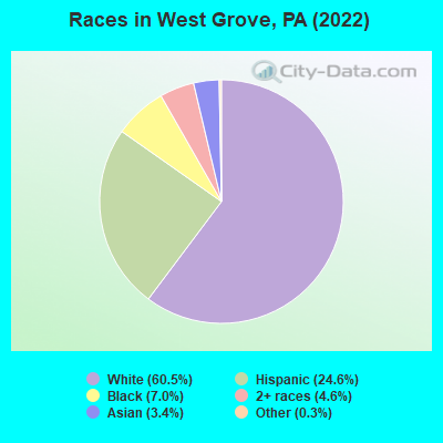
Races in West Grove detailed stats: ancestries, foreign born residents, place of birth
According to our research of Pennsylvania and other state lists, there were 15 registered sex offenders living in West Grove, Pennsylvania as of April 27, 2024.
The ratio of all residents to sex offenders in West Grove is 192 to 1.
 Recent articles from our blog. Our writers, many of them Ph.D. graduates or candidates, create easy-to-read articles on a wide variety of topics.

 | Retirement Move from Newton, MA to PA (Philly Suburbs) (73 replies) |
| High radon reading in PA (14 replies) |
| Moving to PA w/in 11 Months (15 replies) |
| Family Doctor in Chester Co (3 replies) |
| Avon Grove Area (2 replies) |
| what is oxford pa like (3 replies) |
Latest news from West Grove, PA collected exclusively by city-data.com from local newspapers, TV, and radio stations
Ancestries: American (8.9%), Irish (6.4%), German (6.2%), Italian (4.9%), English (3.9%), Norwegian (1.1%).
Current Local Time: EST time zone
Incorporated on 06/15/1894
Elevation: 440 feet
Land area: 0.63 square miles.
Population density: 4,408 people per square mile (average).
354 residents are foreign born (10.5% Latin America, 1.7% Asia).
| This borough: | 12.5% |
| Pennsylvania: | 7.3% |
Median real estate property taxes paid for housing units with mortgages in 2022: $4,485 (1.6%)
Median real estate property taxes paid for housing units with no mortgage in 2022: $4,349 (1.5%)
Nearest city with pop. 50,000+: Greater Newark, DE (10.8 miles  , pop. 67,114).
Nearest city with pop. 200,000+: Philadelphia, PA (38.2 miles , pop. 1,517,550).
Nearest cities:
), ), ), ), ), Latitude: 39.82 N, Longitude: 75.83 W
Area codes: 610, 484

West Grove, Pennsylvania accommodation & food services, waste management - Economy and Business Data
| Here: | 2.1% |
| Pennsylvania: | 2.9% |
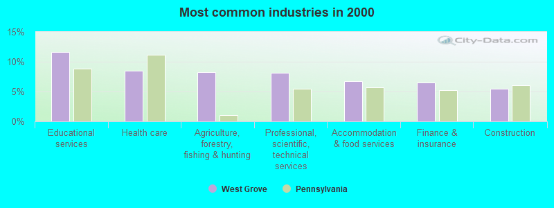
- Educational services (11.7%)
- Health care (8.5%)
- Agriculture, forestry, fishing & hunting (8.2%)
- Professional, scientific, technical services (8.2%)
- Accommodation & food services (6.8%)
- Finance & insurance (6.5%)
- Construction (5.5%)
- Agriculture, forestry, fishing & hunting (11.7%)
- Construction (8.9%)
- Professional, scientific, technical services (6.2%)
- Accommodation & food services (5.5%)
- Educational services (4.8%)
- Finance & insurance (4.5%)
- Truck transportation (4.1%)

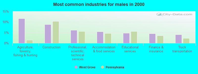
- Educational services (18.7%)
- Health care (13.2%)
- Professional, scientific, technical services (10.2%)
- Finance & insurance (8.5%)
- Accommodation & food services (8.0%)
- Agriculture, forestry, fishing & hunting (4.7%)
- Food & beverage stores (3.2%)

- Agricultural workers, including supervisors (4.7%)
- Preschool, kindergarten, elementary, and middle school teachers (4.5%)
- Other sales and related occupations, including supervisors (4.4%)
- Cooks and food preparation workers (4.3%)
- Other office and administrative support workers, including supervisors (4.0%)
- Secretaries and administrative assistants (3.8%)
- Building and grounds cleaning and maintenance occupations (3.6%)

- Agricultural workers, including supervisors (9.3%)
- Other sales and related occupations, including supervisors (6.3%)
- Operations specialties managers, except financial managers (4.6%)
- Other management occupations, except farmers and farm managers (4.6%)
- Driver/sales workers and truck drivers (4.1%)
- Engineers (3.9%)
- Building and grounds cleaning and maintenance occupations (3.7%)

- Secretaries and administrative assistants (7.8%)
- Preschool, kindergarten, elementary, and middle school teachers (7.6%)
- Cooks and food preparation workers (6.2%)
- Other office and administrative support workers, including supervisors (5.0%)
- Other teachers, instructors, education, training, and library occupations (4.0%)
- Health technologists and technicians (3.7%)
- Building and grounds cleaning and maintenance occupations (3.6%)
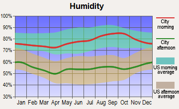
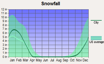
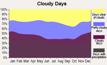
Average climate in West Grove, Pennsylvania
Based on data reported by over 4,000 weather stations


|
|


(lower is better)
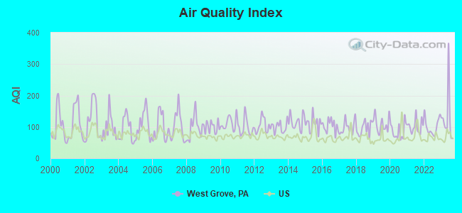
Air Quality Index (AQI) level in 2023 was 130. This is significantly worse than average.
| City: | 130 |
| U.S.: | 73 |
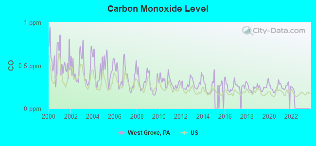
Carbon Monoxide (CO) [ppm] level in 2021 was 0.259. This is about average. Closest monitor was 10.9 miles away from the city center.
| City: | 0.259 |
| U.S.: | 0.251 |
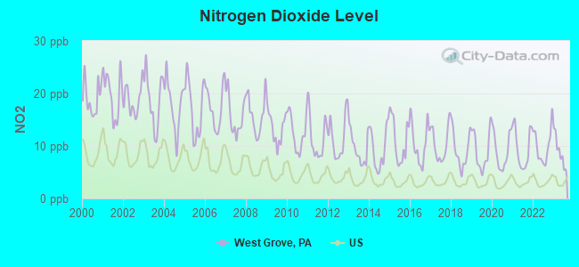
Nitrogen Dioxide (NO2) [ppb] level in 2023 was 8.99. This is significantly worse than average. Closest monitor was 11.3 miles away from the city center.
| City: | 8.99 |
| U.S.: | 5.11 |
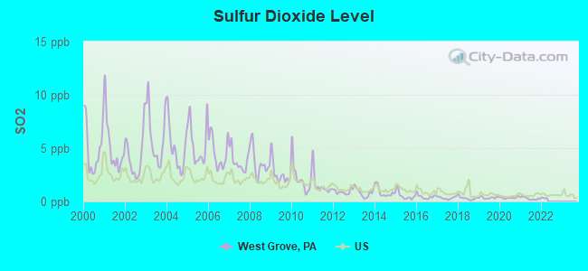
Sulfur Dioxide (SO2) [ppb] level in 2021 was 0.276. This is significantly better than average. Closest monitor was 10.9 miles away from the city center.
| City: | 0.276 |
| U.S.: | 1.515 |
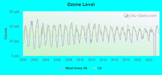
Ozone [ppb] level in 2023 was 36.4. This is about average. Closest monitor was 3.2 miles away from the city center.
| City: | 36.4 |
| U.S.: | 33.3 |
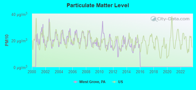
Particulate Matter (PM10) [µg/m3] level in 2015 was 16.7. This is about average. Closest monitor was 10.4 miles away from the city center.
| City: | 16.7 |
| U.S.: | 19.2 |
Particulate Matter (PM2.5) [µg/m3] level in 2023 was 10.9. This is worse than average. Closest monitor was 3.2 miles away from the city center.
| City: | 10.9 |
| U.S.: | 8.1 |
Lead (Pb) [µg/m3] level in 2020 was 0.00328. This is significantly better than average. Closest monitor was 10.4 miles away from the city center.
| City: | 0.00328 |
| U.S.: | 0.00931 |
Tornado activity:
West Grove-area historical tornado activity is slightly above Pennsylvania state average. It is 16% greater than the overall U.S. average.
On 7/27/1994, a category F3 (max. wind speeds 158-206 mph) tornado 4.3 miles away from the West Grove borough center injured 11 people and caused between $500,000 and $5,000,000 in damages.
On 3/22/1955, a category F3 tornado 15.0 miles away from the borough center killed one person and caused between $50,000 and $500,000 in damages.
Earthquake activity:
West Grove-area historical earthquake activity is significantly above Pennsylvania state average. It is 63% smaller than the overall U.S. average.On 8/23/2011 at 17:51:04, a magnitude 5.8 (5.8 MW, Depth: 3.7 mi, Class: Moderate, Intensity: VI - VII) earthquake occurred 174.3 miles away from the city center
On 1/16/1994 at 01:49:16, a magnitude 4.6 (4.6 MB, 4.6 LG, Depth: 3.1 mi, Class: Light, Intensity: IV - V) earthquake occurred 36.9 miles away from the city center
On 1/16/1994 at 00:42:43, a magnitude 4.2 (4.2 MB, 4.0 LG, Depth: 3.1 mi) earthquake occurred 36.2 miles away from West Grove center
On 9/25/1998 at 19:52:52, a magnitude 5.2 (4.8 MB, 4.3 MS, 5.2 LG, 4.5 MW, Depth: 3.1 mi) earthquake occurred 266.1 miles away from the city center
On 11/30/2017 at 21:47:31, a magnitude 4.1 (4.1 MW, Depth: 6.1 mi) earthquake occurred 48.0 miles away from the city center
On 10/7/1983 at 10:18:46, a magnitude 5.3 (5.1 MB, 5.3 LG, 5.1 ML) earthquake occurred 295.8 miles away from West Grove center
Magnitude types: regional Lg-wave magnitude (LG), body-wave magnitude (MB), local magnitude (ML), surface-wave magnitude (MS), moment magnitude (MW)
Natural disasters:
The number of natural disasters in Chester County (23) is greater than the US average (15).Major Disasters (Presidential) Declared: 17
Emergencies Declared: 6
Causes of natural disasters: Floods: 5, Hurricanes: 5, Winter Storms: 5, Storms: 4, Tropical Storms: 4, Snowstorms: 3, Blizzard: 1, Mudslide: 1, Snowfall: 1, Tropical Depression: 1, Water Shortage: 1, Other: 1 (Note: some incidents may be assigned to more than one category).
Hospitals and medical centers in West Grove:
- JENNERSVILLE REGIONAL HOSPITAL (Proprietary, 1015 WEST BALTIMORE PIKE)
- WILLOW TREE HOSPICE (100 SYCAMORE DRIVE)
- CHATHAM ACRES (315 EAST LONDON GROVE ROAD)
- JENNER'S POND HEALTH CENTER (1011 WEST BALTIMORE PIKE)
- PRESTON RESIDENCE (200 SYCAMORE DRIVE)
- JENNERSVILLE DIALYSIS CENTER (1011 WEST BALTIMORE PIKE)
Heliports located in West Grove:
Amtrak stations near West Grove:
- 11 miles: PARKESBURG (WEST 1ST & S. CULVERT STS.) . Services: public payphones, free short-term parking.
- 12 miles: NEWARK (429 S. COLLEGE AVE.) . Services: public payphones, free short-term parking, call for car rental service, call for taxi service, public transit connection.
- 12 miles: COATESVILLE (3RD AVE. & FLEETWOOD ST.) . Services: public payphones, free short-term parking, call for car rental service, call for taxi service.
Colleges/universities with over 2000 students nearest to West Grove:
- Lincoln University of Pennsylvania (about 6 miles; Lincoln University, PA; Full-time enrollment: 2,042)
- University of Delaware (about 11 miles; Newark, DE; FT enrollment: 20,078)
- West Chester University of Pennsylvania (about 16 miles; West Chester, PA; FT enrollment: 14,492)
- Delaware Technical Community College-Stanton/Wilmington (about 16 miles; Wilmington, DE; FT enrollment: 4,972)
- Wilmington University (about 16 miles; New Castle, DE; FT enrollment: 10,072)
- Universal Technical Institute of Pennsylvania Inc (about 19 miles; Exton, PA; FT enrollment: 2,731)
- Immaculata University (about 20 miles; Immaculata, PA; FT enrollment: 2,912)
Public high schools in West Grove:
- AVON GROVE CS (Students: 1,755, Location: 110 EAST STATE ST, Grades: KG-12, Charter school)
- AVON GROVE HS (Location: 257 EAST STATE RD, Grades: 9-12)
- CHESTER COUNTY TECHNICAL COLLEGE HIGH SC (Location: 280 PENNOCKS BRIDGE ROAD, Grades: 9-12)
Public elementary/middle schools in West Grove:
- AVON GROVE INTRMD SCH (Students: 1,616, Location: 395 S. JENNERSVILLE ROAD, Grades: 3-6)
- PENN LONDON EL SCH (Students: 1,111, Location: 383 S JENNERSVILLE RD, Grades: KG-2)
- FRED S ENGLE MS (Students: 900, Location: 107 SCHOOLHOUSE RD, Grades: 7-8)
Private elementary/middle school in West Grove:
User-submitted facts and corrections:
- Schools: White Clay Learning Center is K-8 private school, located at 120 Rose Hill Ave., West Grove PA 19390. Web site is www.whiteclaylearning.org.
- School-White Clay Learning Center (610)274-8031 120 Rosehill Ave. Alternative Private Quaker School, Grades K-8
Points of interest:
Notable location: West Grove Fire Company Station 22 West Grove City (A). Display/hide its location on the map
Birthplace of: Benjamin Reynolds - Politician, Scott Holmes - Actor.
Drinking water stations with addresses in West Grove and their reported violations in the past:
CHATHAM ACRES NURSING HOME (Population served: 120, Groundwater):Past monitoring violations:NEW LONDON UNITED METHODIST (Population served: 100, Groundwater):
- Monitoring of Treatment (SWTR-Unfilt/GWR) - In OCT-2013, Contaminant: GROUNDWATER RULE. Follow-up actions: St Public Notif requested (FEB-06-2014), St Violation/Reminder Notice (FEB-06-2014), St Compliance achieved (JUL-09-2014), St Public Notif received (JUL-09-2014)
- Monitoring of Treatment (SWTR-Unfilt/GWR) - In AUG-2013, Contaminant: GROUNDWATER RULE. Follow-up actions: St Public Notif requested (FEB-06-2014), St Violation/Reminder Notice (FEB-06-2014), St Compliance achieved (JUL-09-2014), St Public Notif received (JUL-09-2014)
- Monitoring and Reporting (DBP) - Between JUL-2013 and SEP-2013, Contaminant: Chlorine. Follow-up actions: St Compliance achieved (FEB-05-2014)
- Monitoring and Reporting (DBP) - Between APR-2013 and JUN-2013, Contaminant: Chlorine. Follow-up actions: St Compliance achieved (JUL-12-2013)
- Monitoring and Reporting (DBP) - Between JAN-2012 and MAR-2012, Contaminant: Chlorine. Follow-up actions: St Compliance achieved (MAY-14-2012)
- 4 routine major monitoring violations
- 61 regular monitoring violations
- 10 other older monitoring violations
Past monitoring violations:WARDS RESTAURANT (Population served: 45, Groundwater):
- 2 regular monitoring violations
Past health violations:LONDON GROVE FRIENDS MEETING (Population served: 40, Groundwater):Past monitoring violations:
- MCL, Average - Between JAN-2006 and MAR-2006, Contaminant: Nitrate. Follow-up actions: St Public Notif requested (MAY-03-2006), St Formal NOV issued (MAY-03-2006), St Compliance achieved (AUG-14-2008)
- Monitoring, Source Water (GWR) - Between JUL-28-2014 and AUG-28-2014, Contaminant: E. COLI. Follow-up actions: St Violation/Reminder Notice (SEP-09-2014), St Public Notif requested (SEP-09-2014), St Public Notif received (SEP-09-2014), St Compliance achieved (SEP-09-2014)
- 11 routine major monitoring violations
- 20 regular monitoring violations
Past health violations:Past monitoring violations:
- MCL, Single Sample - Between JAN-2009 and DEC-2009, Contaminant: Nitrate. Follow-up actions: St Public Notif requested (APR-23-2009), St Formal NOV issued (APR-23-2009), St Compliance achieved (SEP-18-2009), St BCA signed (SEP-18-2009)
- MCL, Single Sample - Between JAN-2007 and DEC-2007, Contaminant: Nitrate. Follow-up actions: St Public Notif requested (NOV-28-2007), St Violation/Reminder Notice (NOV-28-2007), St Compliance achieved (MAY-19-2008)
- Monitoring, Check/Repeat/Confirmation - Between JAN-2009 and MAR-2009, Contaminant: Nitrate. Follow-up actions: St Compliance achieved (APR-23-2009)
- Monitoring, Check/Repeat/Confirmation - Between JUL-2007 and SEP-2007, Contaminant: Nitrate. Follow-up actions: St Compliance achieved (MAY-19-2008)
- One routine major monitoring violation
| This borough: | 3.2 people |
| Pennsylvania: | 2.5 people |
| This borough: | 77.5% |
| Whole state: | 65.0% |
| This borough: | 7.0% |
| Whole state: | 6.6% |
Likely homosexual households (counted as self-reported same-sex unmarried-partner households)
- Lesbian couples: 0.3% of all households
- Gay men: 0.2% of all households
4 people in religious group quarters in 2000
Banks with branches in West Grove (2011 data):
- National Penn Bank: Jenners Pond Branch at 1498 Greenbriar Lane, branch established on 2000/04/26; Jennersville Branch at 103 Jennersville Rd, branch established on 1998/09/24. Info updated 2008/03/03: Bank assets: $8,395.9 mil, Deposits: $5,879.6 mil, headquarters in Boyertown, PA, positive income, Commercial Lending Specialization, 131 total offices, Holding Company: National Penn Bancshares, Inc.
- Citizens Bank of Pennsylvania: West Grove Branch at 106 West Evergreen Street, branch established on 1923/01/01. Info updated 2010/09/24: Bank assets: $32,316.9 mil, Deposits: $25,297.1 mil, headquarters in Philadelphia, PA, positive income, 396 total offices, Holding Company: Uk Financial Investments Limited
- Fulton Bank, National Association: Jennersville Branch at 861 West Baltimore Pike, branch established on 2003/04/07. Info updated 2010/12/30: Bank assets: $9,041.7 mil, Deposits: $6,700.3 mil, headquarters in Lancaster, PA, positive income, Commercial Lending Specialization, 122 total offices, Holding Company: Fulton Financial Corporation
For population 15 years and over in West Grove:
- Never married: 38.5%
- Now married: 44.4%
- Separated: 2.2%
- Widowed: 4.6%
- Divorced: 10.4%
For population 25 years and over in West Grove:
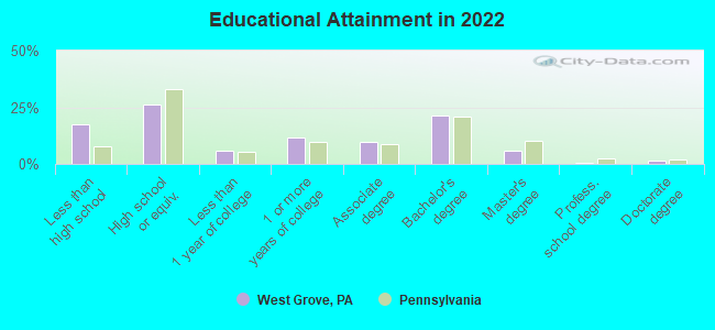
- High school or higher: 83.9%
- Bachelor's degree or higher: 28.6%
- Graduate or professional degree: 7.6%
- Unemployed: 3.4%
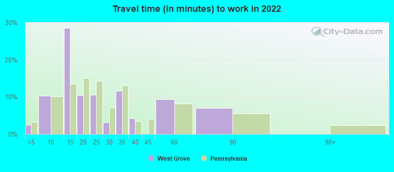
- Mean travel time to work (commute): 24.0 minutes
| Here: | 15.5 |
| Pennsylvania average: | 11.4 |
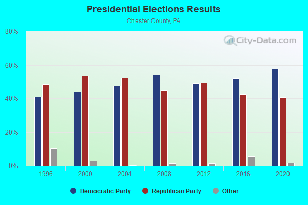
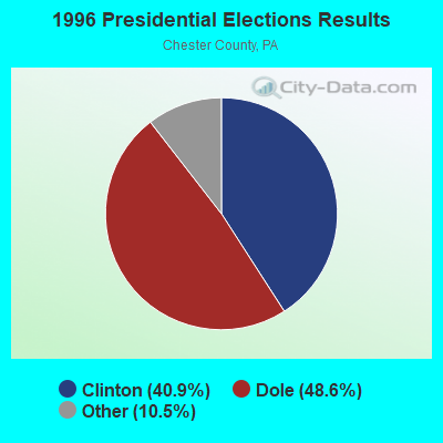
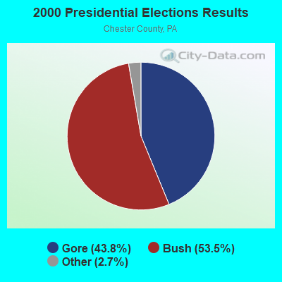

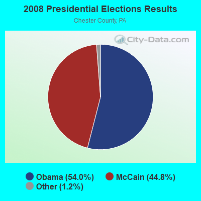
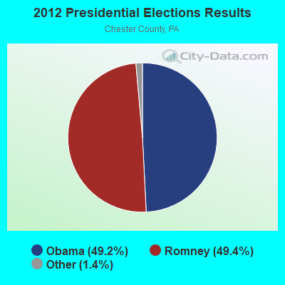

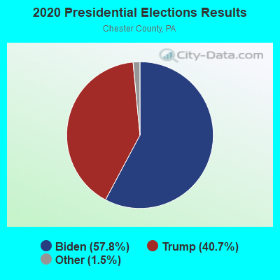
Graphs represent county-level data. Detailed 2008 Election Results
Religion statistics for West Grove, PA (based on Chester County data)
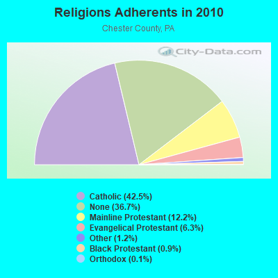
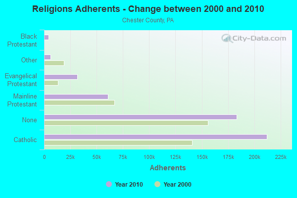
| Religion | Adherents | Congregations |
|---|---|---|
| Catholic | 212,113 | 33 |
| Mainline Protestant | 60,921 | 156 |
| Evangelical Protestant | 31,520 | 167 |
| Other | 6,090 | 25 |
| Black Protestant | 4,271 | 25 |
| Orthodox | 675 | 4 |
| None | 183,296 | - |
Food Environment Statistics:
| Chester County: | 1.54 / 10,000 pop. |
| State: | 2.04 / 10,000 pop. |
| Chester County: | 0.06 / 10,000 pop. |
| Pennsylvania: | 0.09 / 10,000 pop. |
| Chester County: | 0.58 / 10,000 pop. |
| Pennsylvania: | 0.88 / 10,000 pop. |
| Here: | 1.87 / 10,000 pop. |
| Pennsylvania: | 2.52 / 10,000 pop. |
| Chester County: | 6.63 / 10,000 pop. |
| State: | 7.12 / 10,000 pop. |
| Chester County: | 7.5% |
| Pennsylvania: | 9.1% |
| Here: | 22.3% |
| Pennsylvania: | 27.2% |
| Chester County: | 14.0% |
| Pennsylvania: | 11.5% |
Health and Nutrition:
| West Grove: | 45.4% |
| Pennsylvania: | 50.2% |
| Here: | 42.4% |
| Pennsylvania: | 47.1% |
| This city: | 28.5 |
| State: | 28.7 |
| West Grove: | 23.6% |
| Pennsylvania: | 20.8% |
| This city: | 9.3% |
| Pennsylvania: | 10.9% |
| This city: | 6.7 |
| State: | 6.8 |
| This city: | 30.8% |
| State: | 34.3% |
| This city: | 54.1% |
| State: | 56.2% |
| West Grove: | 79.9% |
| Pennsylvania: | 78.3% |
More about Health and Nutrition of West Grove, PA Residents
| Local government employment and payroll (March 2022) | |||||
| Function | Full-time employees | Monthly full-time payroll | Average yearly full-time wage | Part-time employees | Monthly part-time payroll |
|---|---|---|---|---|---|
| Sewerage | 2 | $12,984 | $77,904 | 0 | $0 |
| Financial Administration | 2 | $12,064 | $72,384 | 0 | $0 |
| Parks and Recreation | 1 | $3,601 | $43,212 | 1 | $1,140 |
| Solid Waste Management | 1 | $6,516 | $78,192 | 1 | $18 |
| Water Supply | 1 | $5,081 | $60,972 | 0 | $0 |
| Other and Unallocable | 0 | $0 | 1 | $1,663 | |
| Totals for Government | 7 | $40,246 | $68,993 | 3 | $2,820 |
West Grove government finances - Expenditure in 2017 (per resident):
- Current Operations - Housing and Community Development: $1,841,000 ($657.97)
General - Other: $481,000 ($171.91)
Sewerage: $438,000 ($156.54)
Water Utilities: $367,000 ($131.17)
Police Protection: $313,000 ($111.87)
Central Staff Services: $276,000 ($98.64)
Regular Highways: $205,000 ($73.27)
Solid Waste Management: $170,000 ($60.76)
Parks and Recreation: $64,000 ($22.87)
Local Fire Protection: $52,000 ($18.58)
Protective Inspection and Regulation - Other: $35,000 ($12.51)
Libraries: $13,000 ($4.65)
- General - Interest on Debt: $22,000 ($7.86)
West Grove government finances - Revenue in 2017 (per resident):
- Charges - Sewerage: $678,000 ($242.32)
Other: $94,000 ($33.60)
- Local Intergovernmental - Other: $81,000 ($28.95)
- Miscellaneous - Fines and Forfeits: $21,000 ($7.51)
Interest Earnings: $18,000 ($6.43)
- Revenue - Water Utilities: $275,000 ($98.28)
- State Intergovernmental - Other: $1,778,000 ($635.45)
- Tax - Individual Income: $711,000 ($254.11)
Property: $415,000 ($148.32)
Documentary and Stock Transfer: $51,000 ($18.23)
Public Utility License: $45,000 ($16.08)
West Grove government finances - Debt in 2017 (per resident):
- Long Term Debt - Beginning Outstanding - Unspecified Public Purpose: $557,000 ($199.07)
Outstanding Unspecified Public Purpose: $464,000 ($165.83)
Retired Unspecified Public Purpose: $143,000 ($51.11)
Issue, Unspecified Public Purpose: $50,000 ($17.87)
West Grove government finances - Cash and Securities in 2017 (per resident):
- Other Funds - Cash and Securities: $3,669,000 ($1311.29)
6.84% of this county's 2021 resident taxpayers lived in other counties in 2020 ($103,258 average adjusted gross income)
| Here: | 6.84% |
| Pennsylvania average: | 5.27% |
0.01% of residents moved from foreign countries
Chester County: 0.01% Pennsylvania average: 0.01%
Top counties from which taxpayers relocated into this county between 2020 and 2021:
| from Montgomery County, PA | |
| from Delaware County, PA | |
| from Philadelphia County, PA |
5.95% of this county's 2020 resident taxpayers moved to other counties in 2021 ($116,684 average adjusted gross income)
| Here: | 5.95% |
| Pennsylvania average: | 5.44% |
0.01% of residents moved to foreign countries ($128 average AGI)
Chester County: 0.01% Pennsylvania average: 0.01%
Top counties to which taxpayers relocated from this county between 2020 and 2021:
| to Montgomery County, PA | |
| to Delaware County, PA | |
| to Philadelphia County, PA |
| Businesses in West Grove, PA | ||||
| Name | Count | Name | Count | |
|---|---|---|---|---|
| AT&T | 2 | FedEx | 3 | |
| Blockbuster | 1 | Giant | 1 | |
| CVS | 1 | MasterBrand Cabinets | 2 | |
| Cricket Wireless | 1 | Starbucks | 1 | |
| Curves | 1 | U-Haul | 1 | |
| DHL | 1 | UPS | 2 | |
| Dairy Queen | 1 | YMCA | 1 | |
Strongest AM radio stations in West Grove:
- WVCH (740 AM; 50 kW; CHESTER, PA; Owner: WVCH COMMUNICATIONS, INC.)
- WPEN (950 AM; 50 kW; PHILADELPHIA, PA; Owner: GREATER PHILADELPHIA RADIO, INC.)
- WZZD (990 AM; 50 kW; PHILADELPHIA, PA; Owner: PENNSYLVANIA MEDIA ASSOCIATES, INC.)
- KYW (1060 AM; 50 kW; PHILADELPHIA, PA; Owner: INFINITY BROADCASTING OPERATIONS, INC.)
- WWJZ (640 AM; 50 kW; MOUNT HOLLY, NJ; Owner: ABC, INC.)
- WNWR (1540 AM; 50 kW; PHILADELPHIA, PA)
- WPHT (1210 AM; 50 kW; PHILADELPHIA, PA; Owner: INFINITY BROADCASTING OPERATIONS, INC.)
- WCOJ (1420 AM; 5 kW; COATESVILLE, PA; Owner: WCOJ RADIO COMPANY, INC.)
- WCBM (680 AM; 50 kW; BALTIMORE, MD; Owner: WCBM MARYLAND, INC.)
- WDEL (1150 AM; 5 kW; WILMINGTON, DE; Owner: DELMARVA BROADCASTING COMPANY)
- WEEU (830 AM; 20 kW; READING, PA; Owner: WEEU BROADCASTING COMPANY)
- WTMC (1380 AM; 5 kW; WILMINGTON, DE; Owner: STATE OF DELAWARE DEPARTMENT OF TRAN)
- WWLG (1370 AM; 50 kW; BALTIMORE, MD; Owner: M-10 BROADCASTING, INC.)
Strongest FM radio stations in West Grove:
- WPLY (100.3 FM; MEDIA, PA; Owner: RADIO ONE LICENSES, LLC)
- WDAC (94.5 FM; LANCASTER, PA; Owner: WDAC RADIO COMPANY)
- WSTW (93.7 FM; WILMINGTON, DE; Owner: DELMARVA BROADCASTING COMPANY)
- WJBR-FM (99.5 FM; WILMINGTON, DE; Owner: NM LICENSING, LLC)
- WIOV-FM (105.1 FM; EPHRATA, PA; Owner: REGENT BROADCASTING OF LANCASTER, INC.)
- WBMP (88.1 FM; WARWICK, PA; Owner: FOUR RIVERS COMMUNITY BROADCASTING CORP.)
- WMWX (95.7 FM; PHILADELPHIA, PA; Owner: GREATER PHILADELPHIA RADIO, INC.)
- WMGK (102.9 FM; PHILADELPHIA, PA; Owner: GREATER PHILADELPHIA RADIO, INC.)
- WOGL (98.1 FM; PHILADELPHIA, PA; Owner: INFINITY BROADCASTING OPERATIONS, INC.)
- WSNI-FM (104.5 FM; PHILADELPHIA, PA; Owner: AMFM RADIO LICENSES, L.L.C.)
- WBEB (101.1 FM; PHILADELPHIA, PA; Owner: WEAZ-FM RADIO, INC.)
- WRTI (90.1 FM; PHILADELPHIA, PA; Owner: TEMPLE UNIV. OF THE COMMONWEALTH, ET)
- WPHI-FM (103.9 FM; JENKINTOWN, PA; Owner: RADIO ONE LICENSES, LLC)
- WARM-FM (103.3 FM; YORK, PA; Owner: WSBA LICO, INC.)
- WROZ (101.3 FM; LANCASTER, PA; Owner: HALL COMMUNICATIONS, INC.)
- WXPN (88.5 FM; PHILADELPHIA, PA; Owner: TRUSTEES OF THE UNIVERSITY OF PENNA.)
- WXCY (103.7 FM; HAVRE DE GRACE, MD; Owner: DELMARVA BROADCASTING COMPANY)
- WHYY-FM (90.9 FM; PHILADELPHIA, PA; Owner: WHYY, INC.)
- WXTU (92.5 FM; PHILADELPHIA, PA; Owner: WXTU LICENSE LIMITED PARTNERSHIP)
- WYSP (94.1 FM; PHILADELPHIA, PA; Owner: INFINITY BROADCASTING OPERATIONS, INC.)
TV broadcast stations around West Grove:
- WTSD-CA (Channel 14; WILMINGTON, DE; Owner: PRIORITY COMMUNICATIONS MINISTRIES, INC.)
- KYW-TV (Channel 3; PHILADELPHIA, PA; Owner: CBS BROADCASTING INC.)
- WPHL-TV (Channel 17; PHILADELPHIA, PA; Owner: TRIBUNE TELEVISION COMPANY)
- WPPX (Channel 61; WILMINGTON, DE; Owner: PAXSON PHILADELPHIA LICENSE, INC.)
- WPVI-TV (Channel 6; PHILADELPHIA, PA; Owner: ABC, INC.)
- WPSG (Channel 57; PHILADELPHIA, PA; Owner: VIACOM STATIONS GROUP OF PHILADELPHIA INC.)
- WCAU (Channel 10; PHILADELPHIA, PA; Owner: NBC SUBSIDIARY (WCAU-TV), L.P.)
- WGTW (Channel 48; BURLINGTON, NJ; Owner: BRUNSON COMMUNICATIONS, INC.)
- WYBE (Channel 35; PHILADELPHIA, PA; Owner: INDEPENDENCE PUBLIC MEDIA OF PHILADELPHIA, INC.)
- WWJT-LP (Channel 7; PHILADELPHIA, PA; Owner: PHILADELPHIA TELEVISION NETWORK, INC)
- WHYY-TV (Channel 12; WILMINGTON, DE; Owner: WHYY, INC.)
- WTXF-TV (Channel 29; PHILADELPHIA, PA; Owner: FOX TV STATIONS OF PHILADELPHIA)
- WELL-LP (Channel 8; WILLOW GROVE, ETC., PA; Owner: WORD OF GOD FELLOWSHIP, INC.)
- WTVE (Channel 51; READING, PA; Owner: READING BROADCASTING, INC.)
- W40AZ (Channel 40; WILMINGTON, DE; Owner: NATIONAL MINORITY T.V., INC.)
- W55BT (Channel 55; TALLEYVILLE, DE; Owner: MEDIACASTING LLC)
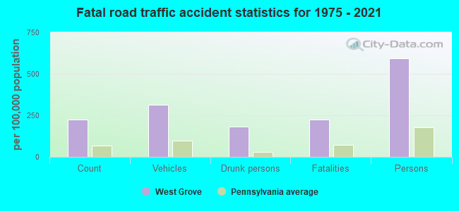
West Grove fatal accident list:
Jun 8, 1996 05:45 PM, 3026, Vehicles: 2, Persons: 2, Fatalities: 1
Jul 5, 1990 04:05 PM, Unk Alley, Vehicles: 1, Persons: 2, Fatalities: 1
Mar 13, 1980 09:00 PM, Vehicles: 1, Persons: 3, Fatalities: 1, Drunk persons involved: 1
Jan 28, 1978 11:00 PM, Vehicles: 2, Persons: 4, Fatalities: 1, Drunk persons involved: 2
- National Bridge Inventory (NBI) Statistics
- 32Number of bridges
- 128ft / 39.4mTotal length
- $764,000Total costs
- 177,932Total average daily traffic
- 17,294Total average daily truck traffic
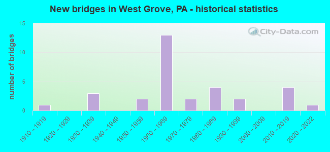
- New bridges - historical statistics
- 11910-1919
- 31930-1939
- 21950-1959
- 131960-1969
- 21970-1979
- 41980-1989
- 21990-1999
- 42010-2019
- 12020-2022
FCC Registered Antenna Towers:
47 (See the full list of FCC Registered Antenna Towers in West Grove)FCC Registered Broadcast Land Mobile Towers:
11 (See the full list of FCC Registered Broadcast Land Mobile Towers in West Grove, PA)FCC Registered Microwave Towers:
6- West Grove SB, Lat: 39.819250 Lon: -75.833500, Type: Pole, Structure height: 24.4 m, Call Sign: WQMQ231,
Assigned Frequencies: 3650.00 MHz, Grant Date: 10/20/2010, Expiration Date: 02/14/2021, Cancellation Date: 03/09/2021, Certifier: Michael Pezzano, Registrant: Exelon Energy, 2900 Lord Baltimore Dr, Baltimore, MD 21244, Phone: (410) 470-8561, Fax: (410) 470-8599, Email:
- Elkview UnitSub, Lat: 39.812972 Lon: -75.899972, Type: Pole, Structure height: 25.9 m, Call Sign: WQMQ231,
Assigned Frequencies: 3650.00 MHz, Grant Date: 10/20/2010, Expiration Date: 02/14/2021, Cancellation Date: 03/09/2021, Certifier: Michael Pezzano, Registrant: Exelon Energy, 2900 Lord Baltimore Dr, Baltimore, MD 21244, Phone: (410) 470-8561, Fax: (410) 470-8599, Email:
- Jennersville Primary, Lat: 39.801250 Lon: -75.881278, Type: Pole, Structure height: 25.9 m, Call Sign: WQMQ231,
Assigned Frequencies: 3650.00 MHz, Grant Date: 10/20/2010, Expiration Date: 02/14/2021, Cancellation Date: 03/09/2021, Certifier: Michael Pezzano, Registrant: Exelon Energy, 2900 Lord Baltimore Dr, Baltimore, MD 21244, Phone: (410) 470-8561, Fax: (410) 470-8599, Email:
- WestGrove ServiceBld, Lat: 39.819639 Lon: -75.833667, Type: Pole, Structure height: 25.9 m, Call Sign: WQMQ231,
Assigned Frequencies: 3650.00 MHz, Grant Date: 10/20/2010, Expiration Date: 02/14/2021, Cancellation Date: 03/09/2021, Certifier: Michael Pezzano, Registrant: Exelon Energy, 2900 Lord Baltimore Dr, Baltimore, MD 21244, Phone: (410) 470-8561, Fax: (410) 470-8599, Email:
- Wicker UnitSub, Lat: 39.796806 Lon: -75.817389, Type: Pole, Structure height: 25.9 m, Call Sign: WQMQ231,
Assigned Frequencies: 3650.00 MHz, Grant Date: 10/20/2010, Expiration Date: 02/14/2021, Cancellation Date: 03/09/2021, Certifier: Michael Pezzano, Registrant: Exelon Energy, 2900 Lord Baltimore Dr, Baltimore, MD 21244, Phone: (410) 470-8561, Fax: (410) 470-8599, Email:
- EPA0503, Rt 41 & Mosquito Lane (Lat: 39.859444 Lon: -75.835556), Type: Ltower, Structure height: 42.6 m, Overall height: 50.3 m, Call Sign: WQSX468,
Assigned Frequencies: 10935.0 MHz, 10975.0 MHz, 10935.0 MHz, 10975.0 MHz, 10935.0 MHz, 10975.0 MHz, 10935.0 MHz, 10975.0 MHz, 10935.0 MHz, 10975.0 MHz... (+10 more), Grant Date: 12/27/2023, Expiration Date: 12/04/2033, Certifier: Brett Lindsey, Registrant: Micronet Communications, Inc., 812 Lexington Dr, Plano, TX 75075, Phone: (972) 422-7200, Email:
FCC Registered Amateur Radio Licenses:
56 (See the full list of FCC Registered Amateur Radio Licenses in West Grove)FAA Registered Aircraft Manufacturers and Dealers:
1 (See the full list of FAA Registered Manufacturers and Dealers in West Grove)FAA Registered Aircraft:
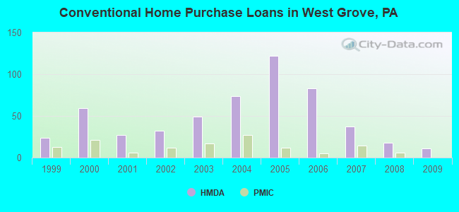
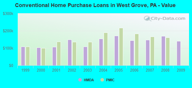
21 (See the full list of FAA Registered Aircraft)| Home Mortgage Disclosure Act Aggregated Statistics For Year 2009 (Based on 1 full tract) | ||||||||||||
| A) FHA, FSA/RHS & VA Home Purchase Loans | B) Conventional Home Purchase Loans | C) Refinancings | D) Home Improvement Loans | F) Non-occupant Loans on < 5 Family Dwellings (A B C & D) | G) Loans On Manufactured Home Dwelling (A B C & D) | |||||||
|---|---|---|---|---|---|---|---|---|---|---|---|---|
| Number | Average Value | Number | Average Value | Number | Average Value | Number | Average Value | Number | Average Value | Number | Average Value | |
| LOANS ORIGINATED | 26 | $198,538 | 11 | $141,364 | 43 | $157,279 | 6 | $123,333 | 1 | $76,000 | 0 | $0 |
| APPLICATIONS APPROVED, NOT ACCEPTED | 1 | $196,000 | 0 | $0 | 11 | $141,000 | 0 | $0 | 1 | $121,000 | 0 | $0 |
| APPLICATIONS DENIED | 2 | $221,000 | 3 | $134,667 | 27 | $152,148 | 5 | $48,400 | 3 | $102,333 | 1 | $49,000 |
| APPLICATIONS WITHDRAWN | 3 | $160,667 | 1 | $168,000 | 11 | $187,364 | 0 | $0 | 1 | $168,000 | 0 | $0 |
| FILES CLOSED FOR INCOMPLETENESS | 1 | $221,000 | 0 | $0 | 5 | $172,000 | 0 | $0 | 0 | $0 | 0 | $0 |
Detailed HMDA statistics for the following Tracts: 3063.00
| Private Mortgage Insurance Companies Aggregated Statistics For Year 2009 (Based on 1 full tract) | ||
| B) Refinancings | ||
|---|---|---|
| Number | Average Value | |
| LOANS ORIGINATED | 2 | $233,000 |
| APPLICATIONS APPROVED, NOT ACCEPTED | 2 | $213,500 |
| APPLICATIONS DENIED | 0 | $0 |
| APPLICATIONS WITHDRAWN | 0 | $0 |
| FILES CLOSED FOR INCOMPLETENESS | 0 | $0 |
Detailed PMIC statistics for the following Tracts: 3063.00
2003 - 2018 National Fire Incident Reporting System (NFIRS) incidents
- Fire incident types reported to NFIRS in West Grove, PA
- 33672.1%Structure Fires
- 6914.8%Outside Fires
- 429.0%Mobile Property/Vehicle Fires
- 194.1%Other
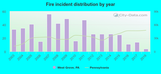 Based on the data from the years 2003 - 2018 the average number of fires per year is 29. The highest number of reported fire incidents - 56 took place in 2007, and the least - 4 in 2018. The data has a decreasing trend.
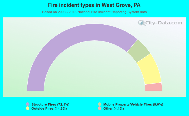 When looking into fire subcategories, the most incidents belonged to: Structure Fires (72.1%), and Outside Fires (14.8%).
| Most common first names in West Grove, PA among deceased individuals | ||
| Name | Count | Lived (average) |
|---|---|---|
| John | 76 | 74.1 years |
| William | 55 | 75.3 years |
| Robert | 52 | 73.7 years |
| James | 46 | 72.4 years |
| Mary | 40 | 78.5 years |
| Helen | 27 | 82.5 years |
| Joseph | 27 | 73.3 years |
| Charles | 26 | 76.7 years |
| Margaret | 23 | 79.4 years |
| Dorothy | 21 | 77.9 years |
| Most common last names in West Grove, PA among deceased individuals | ||
| Last name | Count | Lived (average) |
|---|---|---|
| Smith | 17 | 80.2 years |
| Miller | 17 | 71.6 years |
| Brown | 17 | 74.2 years |
| Davis | 13 | 70.5 years |
| Johnson | 11 | 74.5 years |
| Taylor | 11 | 77.6 years |
| Wilson | 10 | 75.3 years |
| Porter | 10 | 72.5 years |
| Reynolds | 9 | 68.2 years |
| Lee | 9 | 67.8 years |
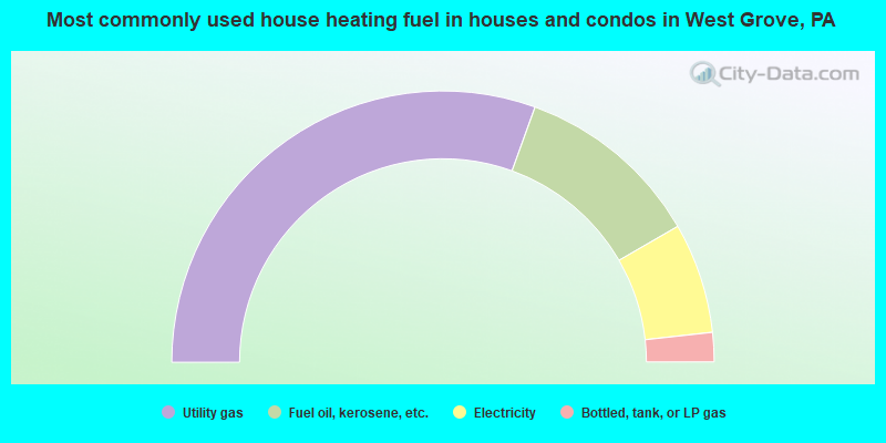
- 61.1%Utility gas
- 22.3%Fuel oil, kerosene, etc.
- 13.2%Electricity
- 3.5%Bottled, tank, or LP gas
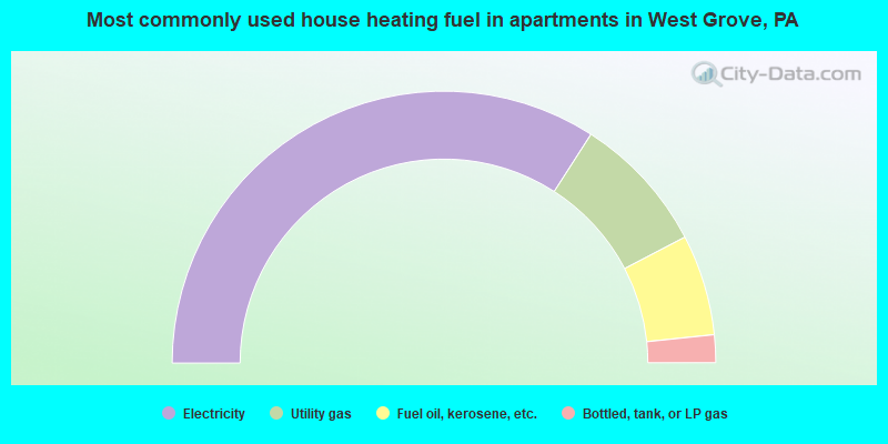
- 68.2%Electricity
- 16.5%Utility gas
- 12.0%Fuel oil, kerosene, etc.
- 3.3%Bottled, tank, or LP gas
West Grove compared to Pennsylvania state average:
- Unemployed percentage significantly below state average.
- Hispanic race population percentage significantly above state average.
- Median age significantly below state average.
- Foreign-born population percentage above state average.
- Length of stay since moving in significantly above state average.

|
|
Total of 148 patent applications in 2008-2024.