Sutton, Massachusetts
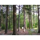
Submit your own pictures of this town and show them to the world
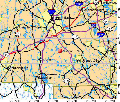
- OSM Map
- General Map
- Google Map
- MSN Map
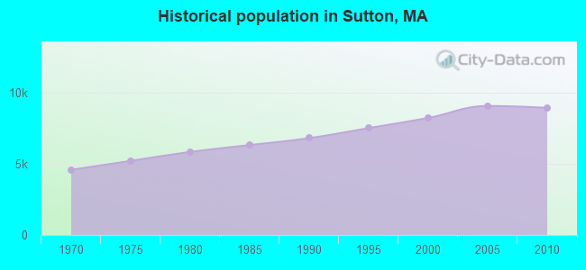
Population change since 2000: +8.6%
 |
| Males: 4,419 | |
| Females: 4,544 |
| Median resident age: | 42.5 years |
| Massachusetts median age: | 39.2 years |
Zip codes: 01590.
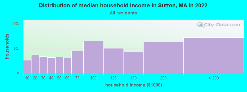
| Sutton: | $135,387 |
| MA: | $94,488 |
Estimated per capita income in 2022: $53,600 (it was $27,490 in 2000)
Sutton town income, earnings, and wages data
Estimated median house or condo value in 2022: $511,443 (it was $185,200 in 2000)
| Sutton: | $511,443 |
| MA: | $534,700 |
Mean prices in 2022: all housing units: $419,164; detached houses: $447,621; townhouses or other attached units: $343,592; in 2-unit structures: $323,295; in 3-to-4-unit structures: $332,295; in 5-or-more-unit structures: $232,758; mobile homes: $113,885
Detailed information about poverty and poor residents in Sutton, MA


- 8,60496.0%White alone
- 1151.3%Hispanic
- 1031.1%Two or more races
- 840.9%Asian alone
- 380.4%Black alone
- 80.09%Native Hawaiian and Other
Pacific Islander alone - 80.09%Other race alone
- 30.03%American Indian alone
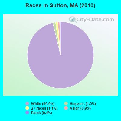
Races in Sutton detailed stats: ancestries, foreign born residents, place of birth
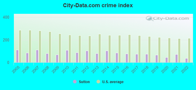
Type |
2009 |
2010 |
2011 |
2012 |
2013 |
2014 |
2015 |
2016 |
2017 |
2018 |
2019 |
2020 |
2021 |
2022 |
|---|---|---|---|---|---|---|---|---|---|---|---|---|---|---|
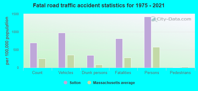
| Murders (per 100,000) | 0 (0.0) | 0 (0.0) | 0 (0.0) | 0 (0.0) | 0 (0.0) | 0 (0.0) | 0 (0.0) | 0 (0.0) | 0 (0.0) | 0 (0.0) | 0 (0.0) | 0 (0.0) | 0 (0.0) | 0 (0.0) |
| Rapes (per 100,000) | 0 (0.0) | 2 (22.3) | 0 (0.0) | 1 (11.0) | 1 (10.9) | 2 (21.7) | 1 (10.8) | 1 (10.8) | 1 (10.6) | 1 (10.5) | 2 (20.9) | 0 (0.0) | 2 (20.6) | 1 (10.6) |
| Robberies (per 100,000) | 3 (32.7) | 0 (0.0) | 0 (0.0) | 1 (11.0) | 0 (0.0) | 0 (0.0) | 1 (10.8) | 1 (10.8) | 0 (0.0) | 1 (10.5) | 0 (0.0) | 0 (0.0) | 2 (20.6) | 0 (0.0) |
| Assaults (per 100,000) | 7 (76.3) | 9 (100.4) | 3 (33.3) | 8 (88.2) | 3 (32.8) | 7 (76.1) | 7 (75.6) | 6 (64.6) | 8 (85.1) | 13 (136.5) | 10 (104.7) | 8 (83.3) | 11 (113.2) | 3 (31.9) |
| Burglaries (per 100,000) | 23 (250.7) | 60 (669.4) | 55 (609.9) | 55 (606.1) | 46 (503.4) | 54 (587.0) | 57 (615.3) | 40 (430.5) | 29 (308.5) | 17 (178.4) | 18 (188.5) | 18 (187.5) | 17 (175.0) | 10 (106.2) |
| Thefts (per 100,000) | 46 (501.4) | 43 (479.8) | 70 (776.2) | 52 (573.0) | 55 (601.9) | 58 (630.4) | 33 (356.2) | 45 (484.3) | 48 (510.6) | 45 (472.3) | 33 (345.5) | 30 (312.5) | 33 (339.6) | 30 (318.5) |
| Auto thefts (per 100,000) | 7 (76.3) | 7 (78.1) | 10 (110.9) | 9 (99.2) | 5 (54.7) | 6 (65.2) | 1 (10.8) | 4 (43.0) | 7 (74.5) | 5 (52.5) | 2 (20.9) | 5 (52.1) | 2 (20.6) | 3 (31.9) |
| Arson (per 100,000) | 0 (0.0) | 3 (33.5) | 0 (0.0) | 0 (0.0) | 0 (0.0) | 1 (10.9) | 0 (0.0) | 3 (32.3) | 1 (10.6) | 0 (0.0) | 0 (0.0) | 0 (0.0) | 0 (0.0) | 0 (0.0) |
| City-Data.com crime index | 68.8 | 110.2 | 89.3 | 103.0 | 79.0 | 104.1 | 85.2 | 77.7 | 73.5 | 74.4 | 66.4 | 46.5 | 72.8 | 37.6 |
The City-Data.com crime index weighs serious crimes and violent crimes more heavily. Higher means more crime, U.S. average is 246.1. It adjusts for the number of visitors and daily workers commuting into cities.
Crime rate in Sutton detailed stats: murders, rapes, robberies, assaults, burglaries, thefts, arson
Full-time law enforcement employees in 2020, including police officers: 19 (15 officers - 14 male; 1 female).
| Officers per 1,000 residents here: | 1.56 |
| Massachusetts average: | 2.59 |
 Recent articles from our blog. Our writers, many of them Ph.D. graduates or candidates, create easy-to-read articles on a wide variety of topics.

 | What is living in Sutton, MA like? (18 replies) |
| Gov Declares "State of Emergency" for Migrant Crisis (1384 replies) |
| Will new construction homes ever be affordable again? (69 replies) |
| Like he** I'm going to pay these prices! (684 replies) |
| Shooting at the South Shore Plaza (122 replies) |
| Do 24 hour grocery stores not exist in New England? (112 replies) |
Latest news from Sutton, MA collected exclusively by city-data.com from local newspapers, TV, and radio stations
Sutton, MA City Guides:
Ancestries: Irish (26.8%), French (19.1%), English (13.9%), Italian (13.3%), Polish (8.5%), French Canadian (8.3%).
Current Local Time: EST time zone
Incorporated in 1714
Elevation: 706 feet
Land area: 32.4 square miles.
Population density: 277 people per square mile (very low).
205 residents are foreign born (1.0% Europe, 0.6% Latin America, 0.4% Africa, 0.3% North America).
| This town: | 2.5% |
| Massachusetts: | 12.2% |
| Sutton town: | 1.3% ($2,394) |
| Massachusetts: | 1.3% ($2,336) |
Nearest city with pop. 50,000+: Worcester, MA  (9.7 miles , pop. 172,648).
Nearest city with pop. 200,000+: Boston, MA (35.8 miles , pop. 589,141).
Nearest city with pop. 1,000,000+: Bronx, NY (141.9 miles , pop. 1,332,650).
Nearest cities:
), ), ), Latitude: 42.14 N, Longitude: 71.74 W
Area code commonly used in this area: 508

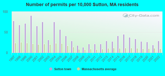
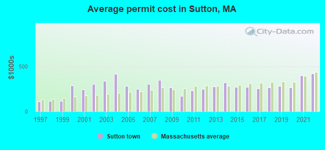
Single-family new house construction building permits:
- 2022: 24 buildings, average cost: $419,100
- 2021: 16 buildings, average cost: $397,600
- 2020: 22 buildings, average cost: $263,500
- 2019: 23 buildings, average cost: $279,900
- 2018: 28 buildings, average cost: $265,300
- 2017: 31 buildings, average cost: $253,700
- 2016: 37 buildings, average cost: $272,200
- 2015: 34 buildings, average cost: $272,200
- 2014: 23 buildings, average cost: $318,900
- 2013: 24 buildings, average cost: $277,100
- 2012: 18 buildings, average cost: $248,000
- 2011: 18 buildings, average cost: $233,600
- 2010: 18 buildings, average cost: $171,700
- 2009: 11 buildings, average cost: $264,800
- 2008: 15 buildings, average cost: $347,300
- 2007: 24 buildings, average cost: $305,400
- 2006: 34 buildings, average cost: $250,900
- 2005: 47 buildings, average cost: $283,900
- 2004: 62 buildings, average cost: $415,900
- 2003: 26 buildings, average cost: $336,900
- 2002: 62 buildings, average cost: $301,500
- 2001: 54 buildings, average cost: $242,100
- 2000: 75 buildings, average cost: $288,300
- 1999: 59 buildings, average cost: $113,800
- 1998: 56 buildings, average cost: $114,200
- 1997: 64 buildings, average cost: $112,700
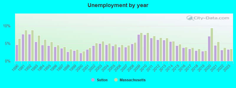
| Here: | 3.3% |
| Massachusetts: | 3.5% |
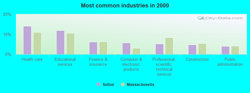
- Health care (14.1%)
- Educational services (12.0%)
- Finance & insurance (6.2%)
- Computer & electronic products (5.8%)
- Professional, scientific, technical services (5.2%)
- Construction (4.8%)
- Public administration (4.1%)
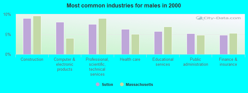
- Construction (9.0%)
- Computer & electronic products (8.1%)
- Professional, scientific, technical services (7.5%)
- Health care (6.2%)
- Educational services (5.7%)
- Public administration (5.2%)
- Finance & insurance (4.8%)
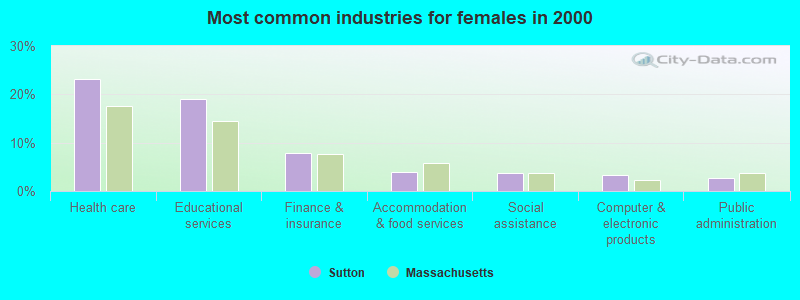
- Health care (23.1%)
- Educational services (19.1%)
- Finance & insurance (7.9%)
- Accommodation & food services (3.9%)
- Social assistance (3.7%)
- Computer & electronic products (3.2%)
- Public administration (2.8%)
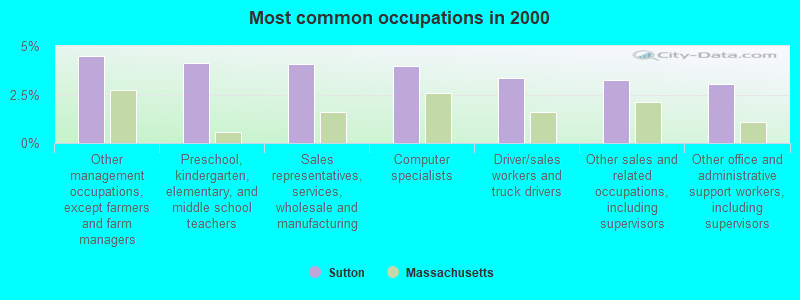
- Other management occupations, except farmers and farm managers (4.5%)
- Preschool, kindergarten, elementary, and middle school teachers (4.1%)
- Sales representatives, services, wholesale and manufacturing (4.1%)
- Computer specialists (3.9%)
- Driver/sales workers and truck drivers (3.4%)
- Other sales and related occupations, including supervisors (3.2%)
- Other office and administrative support workers, including supervisors (3.0%)
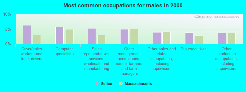
- Driver/sales workers and truck drivers (6.3%)
- Computer specialists (5.8%)
- Sales representatives, services, wholesale and manufacturing (5.3%)
- Other management occupations, except farmers and farm managers (4.9%)
- Other sales and related occupations, including supervisors (3.9%)
- Top executives (3.8%)
- Other production occupations, including supervisors (3.7%)
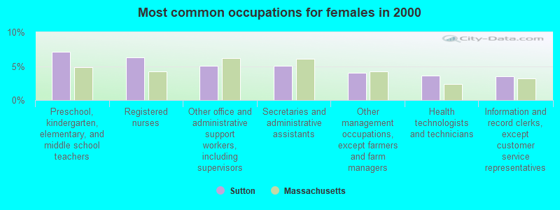
- Preschool, kindergarten, elementary, and middle school teachers (7.1%)
- Registered nurses (6.3%)
- Other office and administrative support workers, including supervisors (5.0%)
- Secretaries and administrative assistants (5.0%)
- Other management occupations, except farmers and farm managers (4.0%)
- Health technologists and technicians (3.6%)
- Information and record clerks, except customer service representatives (3.6%)
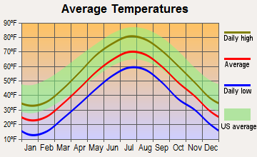
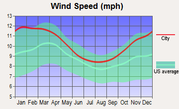
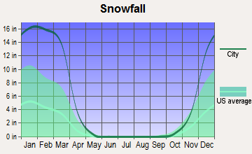
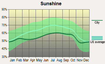
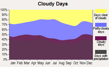
Average climate in Sutton, Massachusetts
Based on data reported by over 4,000 weather stations
(lower is better)
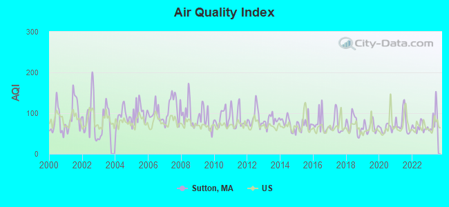
Air Quality Index (AQI) level in 2023 was 83.5. This is about average.
| City: | 83.5 |
| U.S.: | 72.6 |
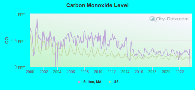
Carbon Monoxide (CO) [ppm] level in 2022 was 0.259. This is about average. Closest monitor was 9.0 miles away from the city center.
| City: | 0.259 |
| U.S.: | 0.251 |
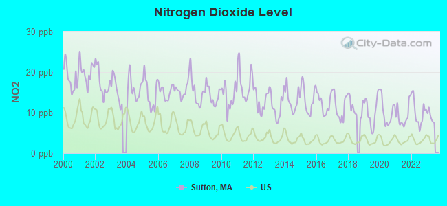
Nitrogen Dioxide (NO2) [ppb] level in 2022 was 10.1. This is significantly worse than average. Closest monitor was 8.9 miles away from the city center.
| City: | 10.1 |
| U.S.: | 5.1 |
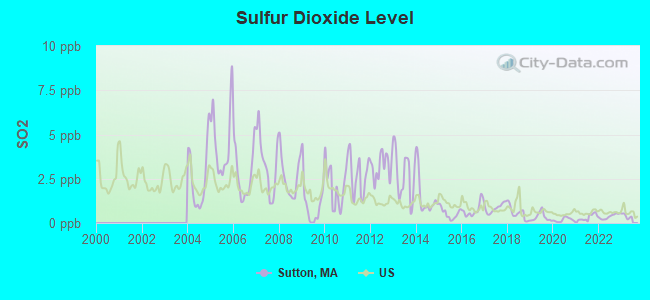
Sulfur Dioxide (SO2) [ppb] level in 2022 was 0.370. This is significantly better than average. Closest monitor was 8.9 miles away from the city center.
| City: | 0.370 |
| U.S.: | 1.515 |
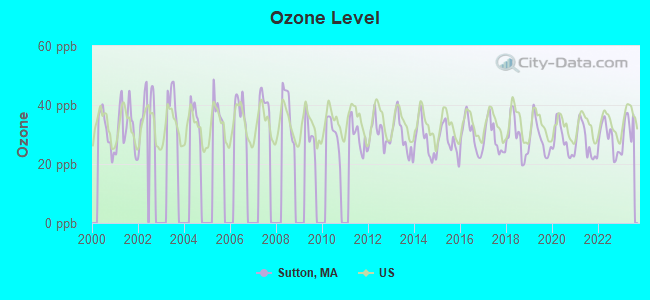
Ozone [ppb] level in 2023 was 32.1. This is about average. Closest monitor was 6.8 miles away from the city center.
| City: | 32.1 |
| U.S.: | 33.3 |
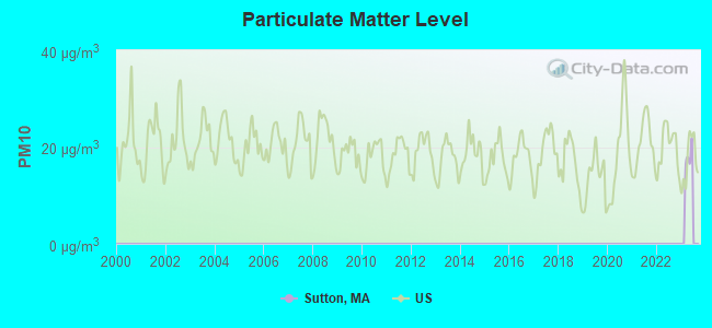
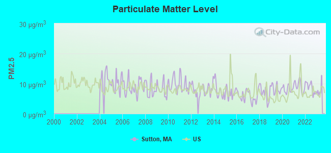
Particulate Matter (PM2.5) [µg/m3] level in 2022 was 8.71. This is about average. Closest monitor was 9.0 miles away from the city center.
| City: | 8.71 |
| U.S.: | 8.11 |
Tornado activity:
Sutton-area historical tornado activity is slightly above Massachusetts state average. It is 25% smaller than the overall U.S. average.
On 6/9/1953, a category F4 (max. wind speeds 207-260 mph) tornado 16.0 miles away from the Sutton town center killed 90 people and injured 1228 people and caused between $50,000,000 and $500,000,000 in damages.
On 6/9/1953, a category F3 (max. wind speeds 158-206 mph) tornado 2.7 miles away from the town center injured 17 people and caused between $500,000 and $5,000,000 in damages.
Earthquake activity:
Sutton-area historical earthquake activity is significantly above Massachusetts state average. It is 72% smaller than the overall U.S. average.On 10/7/1983 at 10:18:46, a magnitude 5.3 (5.1 MB, 5.3 LG, 5.1 ML, Class: Moderate, Intensity: VI - VII) earthquake occurred 181.8 miles away from Sutton center
On 4/20/2002 at 10:50:47, a magnitude 5.3 (5.3 ML, Depth: 3.0 mi) earthquake occurred 191.5 miles away from Sutton center
On 4/20/2002 at 10:50:47, a magnitude 5.2 (5.2 MB, 4.2 MS, 5.2 MW, 5.0 MW) earthquake occurred 190.6 miles away from the city center
On 1/19/1982 at 00:14:42, a magnitude 4.7 (4.5 MB, 4.7 MD, 4.5 LG, Class: Light, Intensity: IV - V) earthquake occurred 94.6 miles away from the city center
On 10/16/2012 at 23:12:25, a magnitude 4.7 (4.7 ML, Depth: 10.0 mi) earthquake occurred 115.1 miles away from the city center
On 8/22/1992 at 12:20:32, a magnitude 4.8 (4.8 MB, 3.8 MS, 4.7 LG, Depth: 6.2 mi) earthquake occurred 222.5 miles away from Sutton center
Magnitude types: regional Lg-wave magnitude (LG), body-wave magnitude (MB), duration magnitude (MD), local magnitude (ML), surface-wave magnitude (MS), moment magnitude (MW)
Natural disasters:
The number of natural disasters in Worcester County (27) is a lot greater than the US average (15).Major Disasters (Presidential) Declared: 15
Emergencies Declared: 12
Causes of natural disasters: Floods: 9, Storms: 8, Hurricanes: 6, Snowstorms: 5, Winter Storms: 4, Blizzards: 2, Snows: 2, Fire: 1, Heavy Rain: 1, Snowfall: 1, Tornado: 1, Wind: 1 (Note: some incidents may be assigned to more than one category).
Hospitals and medical centers near Sutton:
- MILLBURY CONVALESCENT CTR - OLD (Nursing Home, about 4 miles away; MILLBURY, MA)
- ST CAMILLUS HOSPITAL (Hospital, about 4 miles away; WHITINSVILLE, MA)
- ST CAMILLUS HEALTH CENTER (Nursing Home, about 4 miles away; WHITINSVILLE, MA)
- DISTRICT NURSING SOCIETY INC (Home Health Center, about 4 miles away; MILLBURY, MA)
- PROVIDENCE HOUSE NSG HOME OF MILLBURY (Nursing Home, about 5 miles away; MILLBURY, MA)
- RADIUS HEALTHCARE-MILLBURY (Nursing Home, about 5 miles away; MILLBURY, MA)
- SMITH NURSING HOME (Nursing Home, about 5 miles away; MILLBURY, MA)
Airports located in Sutton:
- Waters Airport (MA97) (Runways: 1)
Amtrak stations near Sutton:
- 10 miles: WORCESTER (WORCHESTER, 45 SHREWSBURY ST.) . Services: ticket office, fully wheelchair accessible, enclosed waiting area, public restrooms, public payphones, vending machines, free short-term parking, free long-term parking, call for taxi service, public transit connection.
- 20 miles: FRAMINGHAM (443 WAVERLY ST.) . Services: public payphones, snack bar, paid short-term parking, taxi stand, public transit connection.
Colleges/universities with over 2000 students nearest to Sutton:
- College of the Holy Cross (about 8 miles; Worcester, MA; Full-time enrollment: 3,125)
- Clark University (about 9 miles; Worcester, MA; FT enrollment: 3,687)
- Worcester Polytechnic Institute (about 11 miles; Worcester, MA; FT enrollment: 3,930)
- Worcester State University (about 11 miles; Worcester, MA; FT enrollment: 5,426)
- Assumption College (about 12 miles; Worcester, MA; FT enrollment: 2,580)
- Quinsigamond Community College (about 13 miles; Worcester, MA; FT enrollment: 5,877)
- Bryant University (about 19 miles; Smithfield, RI; FT enrollment: 3,440)
Public high school in Sutton:
- SUTTON HIGH SCHOOL (Students: 401, Location: 409 BOSTON ROAD, Grades: 9-12)
Public elementary/middle schools in Sutton:
- SUTTON EARLY LEARNING (Students: 453, Location: 383 BOSTON ROAD, Grades: PK-2)
- SUTTON ELEMENTARY (Students: 430, Location: 383 BOSTON ROAD, Grades: 3-5)
- SUTTON MIDDLE SCHOOL (Students: 398, Location: 409 BOSTON ROAD, Grades: 6-8)
Points of interest:
Notable locations in Sutton: Keown Orchard (A), Sutton Fire Department Station 3 (B), Sutton Fire Department Station 1 Headquarters (C). Display/hide their locations on the map
Churches in Sutton include: Saint Marks Church (A), Saint Annes Church (B), First Congregational Church (C). Display/hide their locations on the map
Cemeteries: Sutton Town Cemetery (1), South Sutton Cemetery (2), Sutton Center Cemetery (3), Putnam Cemetery (4), Saint Johns Cemetery (5), Howard Cemetery (6), Armsby Cemetery (7). Display/hide their locations on the map
Lakes, reservoirs, and swamps: Number One Pond (A), Aldrich Pond (B), Welsh Pond (C), Girard Pond (D), Smith Pond (E), Cogan Pond (F), Tuckers Pond (G), Stevens Pond (H). Display/hide their locations on the map
Streams, rivers, and creeks: Cold Spring Brook (A), Casey Brook (B), Dark Brook (C). Display/hide their locations on the map
Parks in Sutton include: Purgatory Chasm State Park (1), Freegrace Marble Farm Historic District (2), Mernill Pond State Reservation (3). Display/hide their locations on the map
Hotels: Econo Lodge Sutton (200 Providence Turn Pike) (1), Econolodge (Route 146) (2). Display/hide their approximate locations on the map
Birthplace of: Rufus Putnam - Continental Army officer, George B. Boomer - Union Army colonel, Solomon Sibley - Judge, Thomas Blanchard - Inventor, Abdi Lidonde - College basketball player (Old Dominion Monarchs), Eunice White Beecher - Writer.
| This town: | 2.8 people |
| Massachusetts: | 2.5 people |
| This town: | 78.4% |
| Whole state: | 63.0% |
| This town: | 5.8% |
| Whole state: | 7.0% |
Likely homosexual households (counted as self-reported same-sex unmarried-partner households)
- Lesbian couples: 0.4% of all households
- Gay men: 0.4% of all households
| This town: | 4.4% |
| Whole state: | 9.3% |
| This town: | 1.9% |
| Whole state: | 4.4% |
4 people in homes for the physically handicapped in 2000
2 people in religious group quarters in 2000
Banks with branches in Sutton (2011 data):
- Bank of America, National Association: Sutton Branch at Route 146 And Boston Road, branch established on 1985/07/09. Info updated 2009/11/18: Bank assets: $1,451,969.3 mil, Deposits: $1,077,176.8 mil, headquarters in Charlotte, NC, positive income, 5782 total offices, Holding Company: Bank Of America Corporation
- UniBank for Savings: Sutton Branch at 156 Worcester/Providence Turnpike, branch established on 2003/02/03. Info updated 2008/03/03: Bank assets: $1,263.1 mil, Deposits: $1,151.5 mil, headquarters in Whitinsville, MA, positive income, 8 total offices, Holding Company: Ufs Bancorp
For population 15 years and over in Sutton:
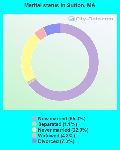
- Never married: 22.0%
- Now married: 65.3%
- Separated: 1.1%
- Widowed: 4.3%
- Divorced: 7.3%
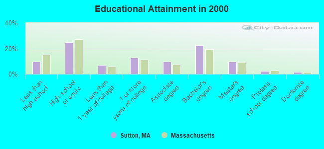
For population 25 years and over in Sutton:
- High school or higher: 90.4%
- Bachelor's degree or higher: 36.0%
- Graduate or professional degree: 13.3%
- Unemployed: 3.1%
- Mean travel time to work (commute): 28.3 minutes
| Here: | 10.5 |
| Massachusetts average: | 13.1 |


Graphs represent county-level data. Detailed 2008 Election Results
Religion statistics for Sutton, MA (based on Worcester County data)


| Religion | Adherents | Congregations |
|---|---|---|
| Catholic | 306,925 | 118 |
| Mainline Protestant | 43,326 | 171 |
| Evangelical Protestant | 37,511 | 203 |
| Other | 18,931 | 69 |
| Orthodox | 7,935 | 15 |
| Black Protestant | 497 | 6 |
| None | 383,427 | - |
Food Environment Statistics:
| This county: | 1.73 / 10,000 pop. |
| Massachusetts: | 1.98 / 10,000 pop. |
| This county: | 0.05 / 10,000 pop. |
| Massachusetts: | 0.05 / 10,000 pop. |
| Worcester County: | 1.79 / 10,000 pop. |
| Massachusetts: | 2.22 / 10,000 pop. |
| This county: | 2.22 / 10,000 pop. |
| Massachusetts: | 1.77 / 10,000 pop. |
| Worcester County: | 7.27 / 10,000 pop. |
| Massachusetts: | 8.76 / 10,000 pop. |
| Worcester County: | 8.0% |
| Massachusetts: | 8.1% |
| This county: | 24.0% |
| Massachusetts: | 22.5% |
| This county: | 16.6% |
| State: | 16.5% |
4.71% of this county's 2021 resident taxpayers lived in other counties in 2020 ($76,229 average adjusted gross income)
| Here: | 4.71% |
| Massachusetts average: | 6.35% |
0.02% of residents moved from foreign countries ($100 average AGI)
Worcester County: 0.02% Massachusetts average: 0.01%
Top counties from which taxpayers relocated into this county between 2020 and 2021:
| from Middlesex County, MA | |
| from Norfolk County, MA | |
| from Suffolk County, MA |
4.84% of this county's 2020 resident taxpayers moved to other counties in 2021 ($87,252 average adjusted gross income)
| Here: | 4.84% |
| Massachusetts average: | 7.18% |
0.03% of residents moved to foreign countries ($199 average AGI)
Worcester County: 0.03% Massachusetts average: 0.02%
Top counties to which taxpayers relocated from this county between 2020 and 2021:
| to Middlesex County, MA | |
| to Norfolk County, MA | |
| to Suffolk County, MA |
| Businesses in Sutton, MA | ||||
| Name | Count | Name | Count | |
|---|---|---|---|---|
| Decora Cabinetry | 2 | MasterBrand Cabinets | 5 | |
| Dunkin Donuts | 1 | Subway | 1 | |
| Econo Lodge | 1 | U-Haul | 1 | |
| Lane Furniture | 1 | |||
Strongest AM radio stations in Sutton:
- WCRN (830 AM; 50 kW; WORCESTER, MA; Owner: CARTER BROADCASTING CORPORATION)
- WALE (990 AM; 50 kW; GREENVILLE, RI; Owner: NORTH AMERICAN BROADCASTING CO., INC.)
- WKOX (1200 AM; 50 kW; FRAMINGHAM, MA; Owner: CAPSTAR TX LIMITED PARTNERSHIP)
- WBIX (1060 AM; 40 kW; NATICK, MA; Owner: LANGER BROADCASTING CORPORATION)
- WVNE (760 AM; daytime; 25 kW; LEICESTER, MA; Owner: BLOUNT MASSCOM, INC.)
- WAMG (890 AM; 25 kW; DEDHAM, MA; Owner: MEGA COMMUNICATIONS OF DEDHAM LICENSEE, LLC)
- WEEI (850 AM; 50 kW; BOSTON, MA; Owner: ENTERCOM BOSTON LICENSE, LLC)
- WORC (1310 AM; 5 kW; WORCESTER, MA; Owner: CHOWDER BROADCAST GROUP LLC)
- WRKO (680 AM; 50 kW; BOSTON, MA; Owner: ENTERCOM BOSTON LICENSE, LLC)
- WTAG (580 AM; 5 kW; WORCESTER, MA; Owner: CAPSTAR TX LIMITED PARTNERSHIP)
- WWZN (1510 AM; 50 kW; BOSTON, MA; Owner: ROSE CITY RADIO CORPORATION)
- WNNZ (640 AM; 50 kW; WESTFIELD, MA; Owner: CLEAR CHANNEL BROADCASTING LICENSES, INC.)
- WVEI (1440 AM; 5 kW; WORCESTER, MA; Owner: ENTERCOM BOSTON LICENSE, LLC)
Strongest FM radio stations in Sutton:
- WAAF (107.3 FM; WORCESTER, MA; Owner: ENTERCOM BOSTON LICENSE, LLC)
- WSRS (96.1 FM; WORCESTER, MA; Owner: CAPSTAR TX LIMITED PARTNERSHIP)
- WICN (90.5 FM; WORCESTER, MA; Owner: WICN PUBLIC RADIO, INC)
- WYCM (90.1 FM; CHARLTON, MA; Owner: BAY PATH VOCATIONAL HIGH SCHOOL)
- WWFX (100.1 FM; SOUTHBRIDGE, MA; Owner: CITADEL BROADCASTING COMPANY)
- WBMX (98.5 FM; BOSTON, MA; Owner: INFINITY RADIO OPERATIONS INC.)
- WJMN (94.5 FM; BOSTON, MA; Owner: AMFM RADIO LICENSES, L.L.C.)
- WCRB (102.5 FM; WALTHAM, MA; Owner: CHARLES RIVER BROADCASTING WCRB LICE)
- WTKK (96.9 FM; BOSTON, MA; Owner: GREATER BOSTON RADIO, INC.)
- WROR-FM (105.7 FM; FRAMINGHAM, MA; Owner: GREATER BOSTON RADIO, INC.)
- WBOS (92.9 FM; BROOKLINE, MA; Owner: GREATER BOSTON RADIO, INC.)
- WWKX (106.3 FM; WOONSOCKET, RI; Owner: AAA ENTERTAINMENT LICENSING LLC)
- WGBH (89.7 FM; BOSTON, MA; Owner: WGBH EDUCATIONAL FOUNDATION)
- WORC-FM (98.9 FM; WEBSTER, MA; Owner: CITADEL BROADCASTING COMPANY)
- WBUR-FM (90.9 FM; BOSTON, MA; Owner: TRUSTEES OF BOSTON UNIVERSITY)
- WWBB (101.5 FM; PROVIDENCE, RI; Owner: CLEAR CHANNEL BROADCASTING LICENSES, INC.)
- WODS (103.3 FM; BOSTON, MA; Owner: INFINITY BROADCASTING OPERATIONS, INC.)
- WXKS-FM (107.9 FM; MEDFORD, MA; Owner: AMFM RADIO LICENSES, L.L.C.)
- WMJX (106.7 FM; BOSTON, MA; Owner: GREATER BOSTON RADIO, INC.)
- WBPR (91.9 FM; WORCESTER, MA; Owner: UNIVERSITY OF MASSACHUSETTS)
TV broadcast stations around Sutton:
- WUNI (Channel 27; WORCESTER, MA; Owner: ENTRAVISION HOLDINGS, LLC)
- WUTF (Channel 66; MARLBOROUGH, MA; Owner: TELEFUTURA BOSTON LLC)
- WCVB-TV (Channel 5; BOSTON, MA; Owner: WCVB HEARST-ARGYLE TV, INC.)
- WGBH-TV (Channel 2; BOSTON, MA; Owner: WGBH EDUCATIONAL FOUNDATION)
- WYDN (Channel 48; WORCESTER, MA; Owner: EDUCATIONAL PUBLIC TV CORPORATION)
- WMFP (Channel 62; LAWRENCE, MA; Owner: WSAH LICENSE, INC.)
- WHDH-TV (Channel 7; BOSTON, MA; Owner: WHDH-TV)
- WBZ-TV (Channel 4; BOSTON, MA; Owner: VIACOM INC.)
- WGBX-TV (Channel 44; BOSTON, MA; Owner: WGBH EDUCATIONAL FOUNDATION)
- WSBK-TV (Channel 38; BOSTON, MA; Owner: VIACOM INC.)
- WLVI-TV (Channel 56; CAMBRIDGE, MA; Owner: WLVI, INC.)
- WCRN-LP (Channel 34; LEICESTER, MA; Owner: CARTER BROADCASTING CORPORATION)
- WFXT (Channel 25; BOSTON, MA; Owner: FOX TELEVISION STATIONS INC.)
- WPXQ (Channel 69; BLOCK ISLAND, RI; Owner: OCEAN STATE TELEVISION, L.L.C.)
- WNAC-TV (Channel 64; PROVIDENCE, RI; Owner: WNAC, LLC)
- WPRI-TV (Channel 12; PROVIDENCE, RI; Owner: TVL BROADCASTING OF RHODE ISLAND, LLC)
- W40BO (Channel 40; BOSTON, MA; Owner: PAXSON COMMUNICATIONS LPTV, INC.)
- WLNE-TV (Channel 6; NEW BEDFORD, MA; Owner: FREEDOM BROADCASTING OF SOUTHERN NEW ENGLAND, INC.)
- WJAR (Channel 10; PROVIDENCE, RI; Owner: OUTLET BROADCASTING, INC.)
- WWDP (Channel 46; NORWELL, MA; Owner: NORWELL TELEVISION, LLC)
- WBPX (Channel 68; BOSTON, MA; Owner: PAXSON BOSTON-68 LICENSE, INC.)
- WSBE-TV (Channel 36; PROVIDENCE, RI; Owner: RHODE ISLAND PUBLIC TELECOM. AUTHORITY)
- WTMU-LP (Channel 32; BOSTON, MA; Owner: ZGS BOSTON, INC.)
- WCEA-LP (Channel 58; BOSTON, MA; Owner: CHANNEL 19 TV CORPORATION)
- WRIW-LP (Channel 50; PROVIDENCE, RI; Owner: ZGS PROVIDENCE, INC.)
- National Bridge Inventory (NBI) Statistics
- 13Number of bridges
- 108ft / 33.5mTotal length
- $13,441,000Total costs
- 152,356Total average daily traffic
- 13,735Total average daily truck traffic
- 471,201Total future (year 2032) average daily traffic
- New bridges - historical statistics
- 31930-1939
- 21950-1959
- 11970-1979
- 61980-1989
- 12010-2019
FCC Registered Antenna Towers:
12 (See the full list of FCC Registered Antenna Towers in Sutton)FCC Registered Broadcast Land Mobile Towers:
10 (See the full list of FCC Registered Broadcast Land Mobile Towers in Sutton, MA)FCC Registered Microwave Towers:
2- Sutton Landfill, 194 Stone School Road (Lat: 42.143667 Lon: -71.711667), Type: Pole, Structure height: 46.3 m, Call Sign: WPQW984,
Assigned Frequencies: 10598.1 MHz, Grant Date: 10/13/2010, Expiration Date: 10/30/2020, Cancellation Date: 06/12/2017, Certifier: Carol L Tacker, Registrant: At&t Mobility LLC, 1120 20th Street, Nw - Suite 1000, Washington, DC 20036, Phone: (202) 457-2055, Fax: (202) 457-3073, Email:
- BOS1106, 7 Kamaitas Road (Lat: 42.165833 Lon: -71.748056), Type: Tower, Structure height: 45.7 m, Overall height: 50.3 m, Call Sign: WQFG730, Licensee ID: L01728370,
Assigned Frequencies: 10875.0 MHz, Grant Date: 07/11/2006, Expiration Date: 07/11/2016, Cancellation Date: 09/09/2013, Certifier: Joseph M Sandri Jr., Registrant: Fibertower Network Services, Corp., Debtor-In-Possession, 1875 Eye Street, Nw, 5th Floor, Room 505, Washington, DC 20006, Phone: (202) 223-1028, Email:
FCC Registered Amateur Radio Licenses:
55 (See the full list of FCC Registered Amateur Radio Licenses in Sutton)FAA Registered Aircraft:
15 (See the full list of FAA Registered Aircraft in Sutton)2002 - 2018 National Fire Incident Reporting System (NFIRS) incidents
- Fire incident types reported to NFIRS in Sutton, MA
- 24845.5%Structure Fires
- 14927.3%Outside Fires
- 9617.6%Mobile Property/Vehicle Fires
- 529.5%Other
 Based on the data from the years 2002 - 2018 the average number of fire incidents per year is 32. The highest number of reported fires - 61 took place in 2015, and the least - 13 in 2008. The data has a dropping trend.
 When looking into fire subcategories, the most incidents belonged to: Structure Fires (45.5%), and Outside Fires (27.3%).
- 80.2%Fuel oil, kerosene, etc.
- 11.9%Electricity
- 2.6%Bottled, tank, or LP gas
- 2.1%Utility gas
- 2.1%Wood
- 0.7%Coal or coke
- 0.3%Other fuel
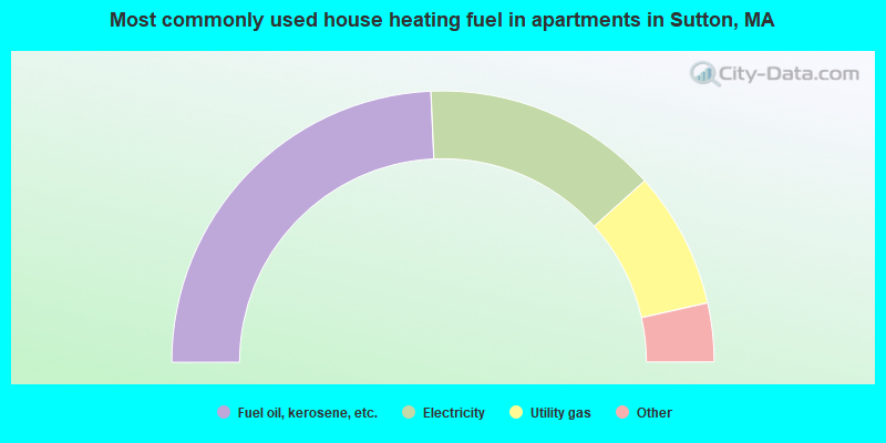
- 48.6%Fuel oil, kerosene, etc.
- 28.1%Electricity
- 16.3%Utility gas
- 3.5%Bottled, tank, or LP gas
- 3.5%Wood
Sutton compared to Massachusetts state average:
- Unemployed percentage significantly below state average.
- Black race population percentage significantly below state average.
- Hispanic race population percentage significantly below state average.
- Foreign-born population percentage significantly below state average.
- Renting percentage significantly below state average.
- Length of stay since moving in significantly above state average.
- Number of rooms per house significantly below state average.
- House age significantly below state average.
Sutton on our top lists:
- #3 on the list of "Top 101 cities with largest percentage of females in industries: machinery, equipment, and supplies merchant wholesalers (population 5,000+)"
- #9 on the list of "Top 101 cities with largest percentage of females in occupations: life, physical, and social science technicians (population 5,000+)"
- #10 on the list of "Top 101 cities with largest percentage of males in industries: machinery, equipment, and supplies merchant wholesalers (population 5,000+)"
- #15 on the list of "Top 101 cities with largest percentage of males in industries: furniture and home furnishing merchant wholesalers (population 5,000+)"
- #21 on the list of "Top 101 cities with largest percentage of females in industries: electrical and electronic goods merchant wholesalers (population 5,000+)"
- #23 on the list of "Top 101 cities with largest percentage of females in occupations: other health diagnosing and treating practitioners and technical occupations (population 5,000+)"
- #24 on the list of "Top 101 cities with largest percentage of males in occupations: mathematical science occupations (population 5,000+)"
- #26 on the list of "Top 101 cities with largest percentage of females in industries: office supplies and stationery stores (population 5,000+)"
- #30 on the list of "Top 101 cities with largest percentage of females in occupations: drafters, engineering, and mapping technicians (population 5,000+)"
- #34 on the list of "Top 101 cities with largest percentage of females in industries: alcoholic beverages merchant wholesalers (population 5,000+)"
- #38 on the list of "Top 101 cities with largest percentage of males in occupations: special education teachers (population 5,000+)"
- #40 on the list of "Top 101 cities with largest percentage of males in occupations: operations specialties managers except financial managers (population 5,000+)"
- #47 on the list of "Top 101 cities with largest percentage of females in industries: health care (population 5,000+)"
- #50 on the list of "Top 101 cities with largest percentage of males in industries: publishing, and motion picture and sound recording industries (population 5,000+)"
- #58 on the list of "Top 101 cities with largest percentage of males in industries: computer and electronic products (population 5,000+)"
- #64 on the list of "Top 101 cities with largest percentage of females in industries: used merchandise, gift, novelty, and souvenir, and other miscellaneous stores (population 5,000+)"
- #68 on the list of "Top 101 cities with largest percentage of females in industries: nonmetallic mineral products (population 5,000+)"
- #70 on the list of "Top 101 cities with largest percentage of males in industries: fuel dealers (population 5,000+)"
- #72 on the list of "Top 101 cities with largest percentage of males in industries: petroleum and petroleum products merchant wholesalers (population 5,000+)"
- #73 on the list of "Top 101 cities with largest percentage of females in industries: paper and paper products merchant wholesalers (population 5,000+)"
- #37 (01590) on the list of "Top 101 zip codes with the largest percentage of Lithuanian first ancestries (pop 5,000+)"
- #4 on the list of "Top 101 counties with the highest carbon monoxide air pollution readings in 2012 (ppm)"
- #5 on the list of "Top 101 counties with the most Catholic congregations"
- #12 on the list of "Top 101 counties with the highest surface withdrawal of fresh water for public supply"
- #16 on the list of "Top 101 counties with the highest total withdrawal of fresh water for public supply"
- #23 on the list of "Top 101 counties with the highest Sulfur Oxides Annual air pollution readings in 2012 (µg/m3)"

|
|
Total of 228 patent applications in 2008-2024.