Grafton, Massachusetts
Submit your own pictures of this town and show them to the world
- OSM Map
- General Map
- Google Map
- MSN Map
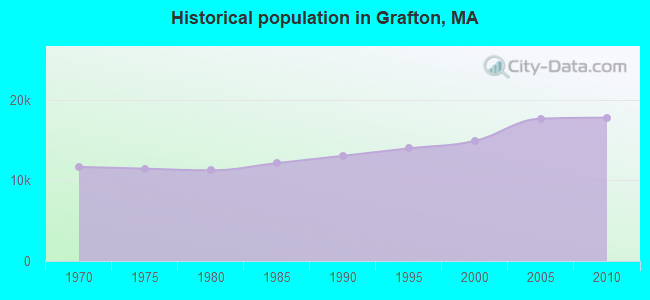
Population change since 2000: +19.3%
 |
| Males: 8,605 | |
| Females: 9,160 |
| Median resident age: | 39.2 years |
| Massachusetts median age: | 39.2 years |
Zip codes: 01536.
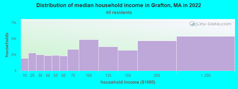
| Grafton: | $100,935 |
| MA: | $94,488 |
Estimated per capita income in 2022: $52,551 (it was $26,952 in 2000)
Grafton town income, earnings, and wages data
Estimated median house or condo value in 2022: $493,217 (it was $178,600 in 2000)
| Grafton: | $493,217 |
| MA: | $534,700 |
Mean prices in 2022: all housing units: $419,164; detached houses: $447,621; townhouses or other attached units: $343,592; in 2-unit structures: $323,295; in 3-to-4-unit structures: $332,295; in 5-or-more-unit structures: $232,758; mobile homes: $113,885
Detailed information about poverty and poor residents in Grafton, MA


- 15,47787.1%White alone
- 1,3707.7%Asian alone
- 4062.3%Hispanic
- 2721.5%Two or more races
- 1841.0%Black alone
- 390.2%Other race alone
- 150.08%American Indian alone
- 20.01%Native Hawaiian and Other
Pacific Islander alone
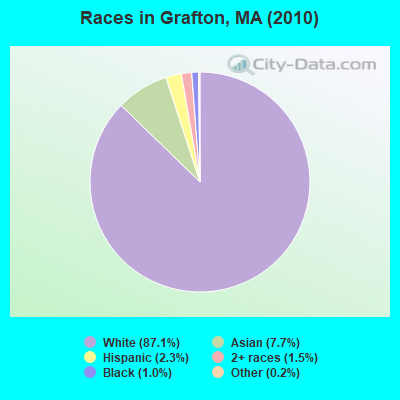
Races in Grafton detailed stats: ancestries, foreign born residents, place of birth
According to our research of Massachusetts and other state lists, there were 11 registered sex offenders living in Grafton, Massachusetts as of May 06, 2024.
The ratio of all residents to sex offenders in Grafton is 1,615 to 1.
The ratio of registered sex offenders to all residents in this city is near the state average.
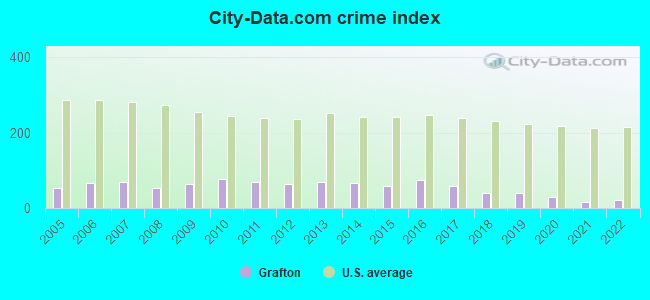
Type |
2009 |
2010 |
2011 |
2012 |
2013 |
2014 |
2015 |
2016 |
2017 |
2018 |
2019 |
2020 |
2021 |
2022 |
|---|---|---|---|---|---|---|---|---|---|---|---|---|---|---|
| Murders (per 100,000) | 0 (0.0) | 0 (0.0) | 0 (0.0) | 0 (0.0) | 0 (0.0) | 0 (0.0) | 0 (0.0) | 0 (0.0) | 0 (0.0) | 0 (0.0) | 0 (0.0) | 0 (0.0) | 0 (0.0) | 0 (0.0) |
| Rapes (per 100,000) | 4 (22.2) | 4 (22.5) | 2 (11.2) | 1 (5.6) | 2 (11.0) | 1 (5.5) | 3 (16.2) | 7 (37.6) | 6 (32.0) | 0 (0.0) | 4 (21.2) | 2 (10.6) | 0 (0.0) | 1 (5.0) |
| Robberies (per 100,000) | 1 (5.6) | 4 (22.5) | 1 (5.6) | 1 (5.6) | 4 (22.0) | 3 (16.4) | 1 (5.4) | 0 (0.0) | 1 (5.3) | 2 (10.6) | 1 (5.3) | 1 (5.3) | 0 (0.0) | 0 (0.0) |
| Assaults (per 100,000) | 12 (66.6) | 19 (107.0) | 17 (95.1) | 20 (111.2) | 17 (93.5) | 30 (163.9) | 22 (118.7) | 22 (118.2) | 14 (74.6) | 19 (100.5) | 10 (53.0) | 7 (37.0) | 9 (46.5) | 11 (55.1) |
| Burglaries (per 100,000) | 40 (222.2) | 38 (213.9) | 43 (240.6) | 40 (222.4) | 40 (220.0) | 34 (185.8) | 26 (140.3) | 19 (102.1) | 11 (58.6) | 13 (68.8) | 10 (53.0) | 3 (15.9) | 3 (15.5) | 8 (40.1) |
| Thefts (per 100,000) | 54 (299.9) | 49 (275.8) | 87 (486.8) | 70 (389.2) | 76 (418.0) | 45 (245.9) | 35 (188.9) | 56 (300.9) | 43 (229.2) | 42 (222.2) | 34 (180.1) | 41 (216.8) | 15 (77.5) | 22 (110.2) |
| Auto thefts (per 100,000) | 6 (33.3) | 9 (50.7) | 5 (28.0) | 7 (38.9) | 5 (27.5) | 5 (27.3) | 6 (32.4) | 5 (26.9) | 6 (32.0) | 6 (31.7) | 2 (10.6) | 5 (26.4) | 8 (41.4) | 0 (0.0) |
| Arson (per 100,000) | 0 (0.0) | 0 (0.0) | 2 (11.2) | 2 (11.1) | 0 (0.0) | 1 (5.5) | 1 (5.4) | 0 (0.0) | 0 (0.0) | 0 (0.0) | 0 (0.0) | 0 (0.0) | 0 (0.0) | 1 (5.0) |
| City-Data.com crime index | 63.0 | 76.2 | 68.2 | 62.6 | 68.4 | 67.1 | 58.3 | 75.1 | 57.9 | 39.5 | 40.9 | 29.4 | 16.8 | 22.2 |
The City-Data.com crime index weighs serious crimes and violent crimes more heavily. Higher means more crime, U.S. average is 246.1. It adjusts for the number of visitors and daily workers commuting into cities.
Crime rate in Grafton detailed stats: murders, rapes, robberies, assaults, burglaries, thefts, arson
Full-time law enforcement employees in 2021, including police officers: 24 (20 officers - 17 male; 3 female).
| Officers per 1,000 residents here: | 1.03 |
| Massachusetts average: | 2.53 |
 Recent articles from our blog. Our writers, many of them Ph.D. graduates or candidates, create easy-to-read articles on a wide variety of topics.

 | Grafton parking availability for train to Boston? (13 replies) |
| Exploring Grafton to purchase first house (11 replies) |
| Info on Grafton and Surrounding Towns (6 replies) |
| Grafton or Shrewsbury to buy (4 replies) |
| One1 job in Hartford 1 in Cambridge - Best town to live (51 replies) |
| New England homebase recs please (13 replies) |
Latest news from Grafton, MA collected exclusively by city-data.com from local newspapers, TV, and radio stations
Ancestries: Irish (27.0%), Italian (16.5%), English (14.4%), French (14.3%), French Canadian (11.2%), Polish (8.1%).
Current Local Time: EST time zone
Incorporated in 1735
Elevation: 425 feet
Land area: 22.7 square miles.
Population density: 781 people per square mile (low).
646 residents are foreign born (1.3% Europe, 1.3% Asia, 1.0% North America, 0.5% Latin America).
| This town: | 4.3% |
| Massachusetts: | 12.2% |
| Grafton town: | 1.3% ($2,347) |
| Massachusetts: | 1.3% ($2,336) |
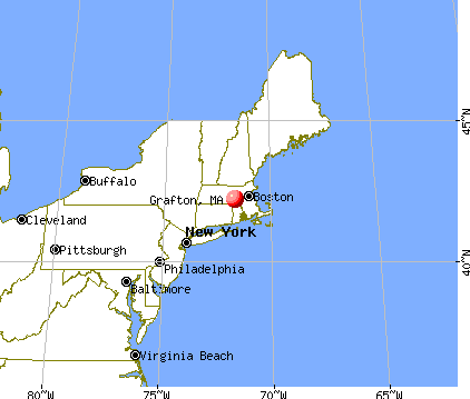
Nearest city with pop. 50,000+: Worcester, MA  (6.9 miles , pop. 172,648).
Nearest city with pop. 200,000+: Boston, MA (32.0 miles , pop. 589,141).
Nearest city with pop. 1,000,000+: Bronx, NY (147.0 miles , pop. 1,332,650).
Nearest cities:
), ), ), Latitude: 42.21 N, Longitude: 71.70 W
Area codes: 508, 774

Grafton, Massachusetts accommodation & food services, waste management - Economy and Business Data
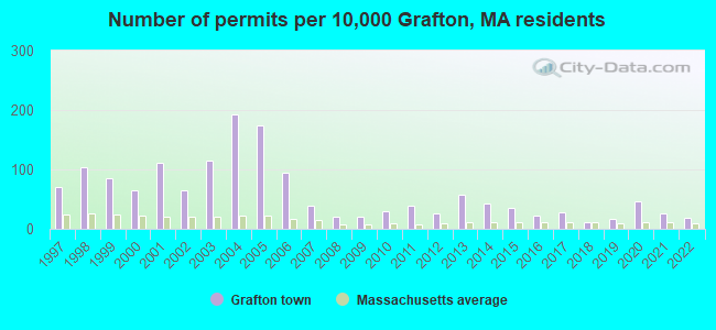
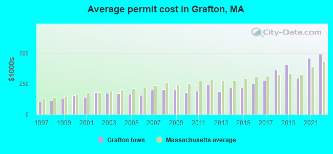
Single-family new house construction building permits:
- 2022: 28 buildings, average cost: $494,900
- 2021: 38 buildings, average cost: $462,400
- 2020: 69 buildings, average cost: $297,600
- 2019: 24 buildings, average cost: $410,100
- 2018: 18 buildings, average cost: $364,500
- 2017: 42 buildings, average cost: $279,000
- 2016: 33 buildings, average cost: $252,500
- 2015: 52 buildings, average cost: $216,200
- 2014: 62 buildings, average cost: $218,000
- 2013: 85 buildings, average cost: $188,200
- 2012: 38 buildings, average cost: $241,800
- 2011: 56 buildings, average cost: $191,600
- 2010: 43 buildings, average cost: $179,900
- 2009: 31 buildings, average cost: $202,500
- 2008: 30 buildings, average cost: $205,500
- 2007: 56 buildings, average cost: $200,200
- 2006: 142 buildings, average cost: $157,000
- 2005: 259 buildings, average cost: $165,600
- 2004: 288 buildings, average cost: $171,000
- 2003: 172 buildings, average cost: $174,600
- 2002: 96 buildings, average cost: $180,400
- 2001: 166 buildings, average cost: $141,500
- 2000: 95 buildings, average cost: $152,600
- 1999: 127 buildings, average cost: $135,800
- 1998: 153 buildings, average cost: $115,400
- 1997: 104 buildings, average cost: $105,400
| Here: | 3.1% |
| Massachusetts: | 3.5% |
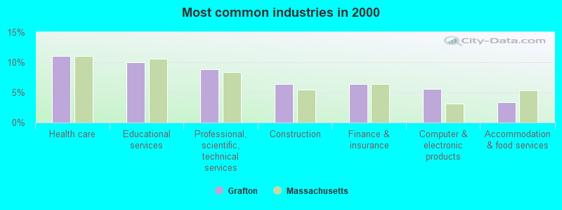
- Health care (11.0%)
- Educational services (10.0%)
- Professional, scientific, technical services (8.9%)
- Construction (6.4%)
- Finance & insurance (6.4%)
- Computer & electronic products (5.6%)
- Accommodation & food services (3.3%)
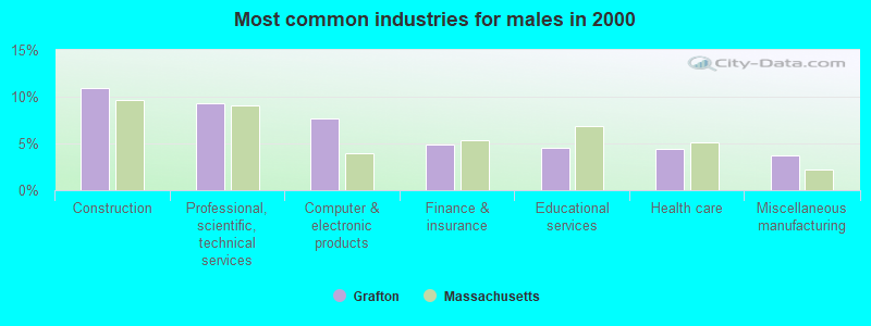
- Construction (11.0%)
- Professional, scientific, technical services (9.3%)
- Computer & electronic products (7.7%)
- Finance & insurance (4.8%)
- Educational services (4.5%)
- Health care (4.5%)
- Miscellaneous manufacturing (3.7%)
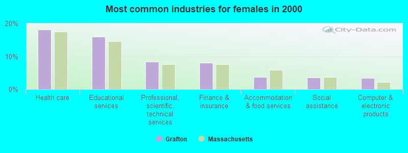
- Health care (18.1%)
- Educational services (15.9%)
- Professional, scientific, technical services (8.4%)
- Finance & insurance (8.1%)
- Accommodation & food services (3.7%)
- Social assistance (3.6%)
- Computer & electronic products (3.4%)
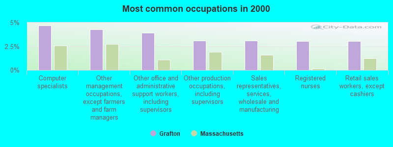
- Computer specialists (4.7%)
- Other management occupations, except farmers and farm managers (4.3%)
- Other office and administrative support workers, including supervisors (3.9%)
- Other production occupations, including supervisors (3.1%)
- Sales representatives, services, wholesale and manufacturing (3.1%)
- Registered nurses (3.1%)
- Retail sales workers, except cashiers (3.1%)
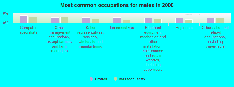
- Computer specialists (6.4%)
- Other management occupations, except farmers and farm managers (4.6%)
- Sales representatives, services, wholesale and manufacturing (4.6%)
- Top executives (4.5%)
- Electrical equipment mechanics and other installation, maintenance, and repair workers, including supervisors (4.5%)
- Engineers (4.3%)
- Other sales and related occupations, including supervisors (4.3%)
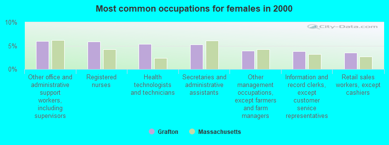
- Other office and administrative support workers, including supervisors (6.0%)
- Registered nurses (5.9%)
- Health technologists and technicians (5.3%)
- Secretaries and administrative assistants (5.3%)
- Other management occupations, except farmers and farm managers (3.9%)
- Information and record clerks, except customer service representatives (3.8%)
- Retail sales workers, except cashiers (3.5%)
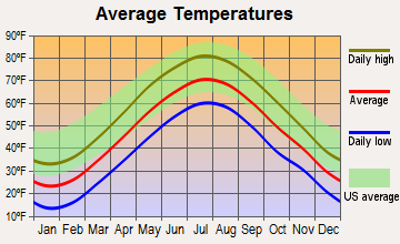
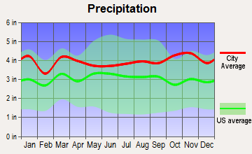
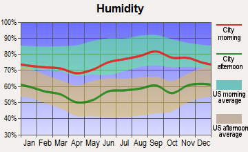
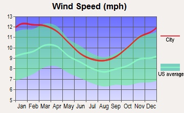
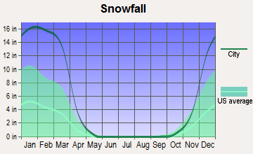
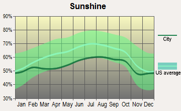
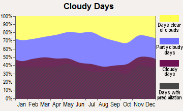
Average climate in Grafton, Massachusetts
Based on data reported by over 4,000 weather stations
(lower is better)

Air Quality Index (AQI) level in 2022 was 64.6. This is about average.
| City: | 64.6 |
| U.S.: | 72.6 |
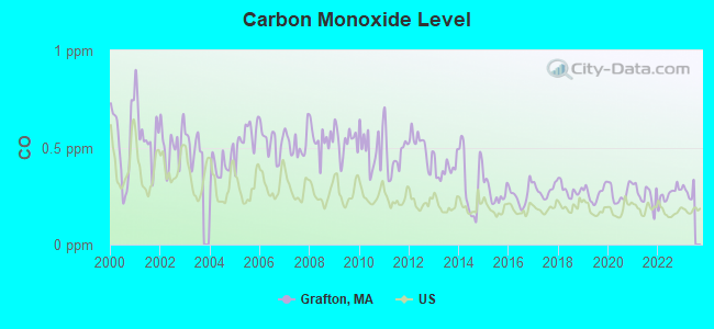
Carbon Monoxide (CO) [ppm] level in 2022 was 0.259. This is about average. Closest monitor was 6.3 miles away from the city center.
| City: | 0.259 |
| U.S.: | 0.251 |
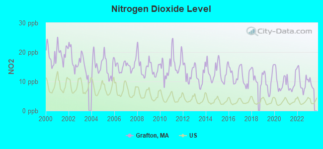
Nitrogen Dioxide (NO2) [ppb] level in 2022 was 10.1. This is significantly worse than average. Closest monitor was 5.5 miles away from the city center.
| City: | 10.1 |
| U.S.: | 5.1 |
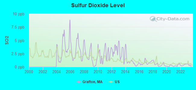
Sulfur Dioxide (SO2) [ppb] level in 2022 was 0.370. This is significantly better than average. Closest monitor was 5.5 miles away from the city center.
| City: | 0.370 |
| U.S.: | 1.515 |
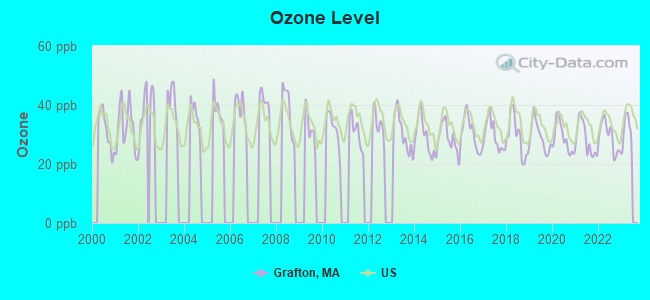
Ozone [ppb] level in 2022 was 29.2. This is about average. Closest monitor was 5.6 miles away from the city center.
| City: | 29.2 |
| U.S.: | 33.3 |
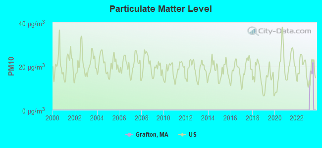
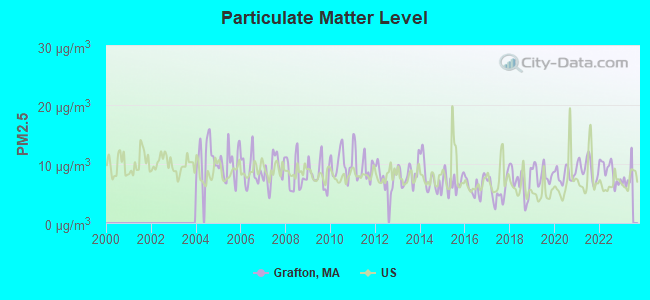
Particulate Matter (PM2.5) [µg/m3] level in 2022 was 8.71. This is about average. Closest monitor was 6.3 miles away from the city center.
| City: | 8.71 |
| U.S.: | 8.11 |
Tornado activity:
Grafton-area historical tornado activity is slightly above Massachusetts state average. It is 25% smaller than the overall U.S. average.
On 6/9/1953, a category F4 (max. wind speeds 207-260 mph) tornado 10.9 miles away from the Grafton town center killed 90 people and injured 1228 people and caused between $50,000,000 and $500,000,000 in damages.
On 6/9/1953, a category F3 (max. wind speeds 158-206 mph) tornado 4.8 miles away from the town center injured 17 people and caused between $500,000 and $5,000,000 in damages.
Earthquake activity:
Grafton-area historical earthquake activity is significantly above Massachusetts state average. It is 72% smaller than the overall U.S. average.On 10/7/1983 at 10:18:46, a magnitude 5.3 (5.1 MB, 5.3 LG, 5.1 ML, Class: Moderate, Intensity: VI - VII) earthquake occurred 180.0 miles away from Grafton center
On 4/20/2002 at 10:50:47, a magnitude 5.3 (5.3 ML, Depth: 3.0 mi) earthquake occurred 188.4 miles away from Grafton center
On 4/20/2002 at 10:50:47, a magnitude 5.2 (5.2 MB, 4.2 MS, 5.2 MW, 5.0 MW) earthquake occurred 187.5 miles away from Grafton center
On 1/19/1982 at 00:14:42, a magnitude 4.7 (4.5 MB, 4.7 MD, 4.5 LG, Class: Light, Intensity: IV - V) earthquake occurred 89.3 miles away from Grafton center
On 10/16/2012 at 23:12:25, a magnitude 4.7 (4.7 ML, Depth: 10.0 mi) earthquake occurred 109.4 miles away from Grafton center
On 8/22/1992 at 12:20:32, a magnitude 4.8 (4.8 MB, 3.8 MS, 4.7 LG, Depth: 6.2 mi) earthquake occurred 226.5 miles away from the city center
Magnitude types: regional Lg-wave magnitude (LG), body-wave magnitude (MB), duration magnitude (MD), local magnitude (ML), surface-wave magnitude (MS), moment magnitude (MW)
Natural disasters:
The number of natural disasters in Worcester County (27) is a lot greater than the US average (15).Major Disasters (Presidential) Declared: 15
Emergencies Declared: 12
Causes of natural disasters: Floods: 9, Storms: 8, Hurricanes: 6, Snowstorms: 5, Winter Storms: 4, Blizzards: 2, Snows: 2, Fire: 1, Heavy Rain: 1, Snowfall: 1, Tornado: 1, Wind: 1 (Note: some incidents may be assigned to more than one category).
Hospitals and medical centers in Grafton:
Other hospitals and medical centers near Grafton:
- BRIGHAM HILL NURSING CENTER (Nursing Home, about 1 miles away; NORTH GRAFTON, MA)
- EDGEWOOD NURSING HOME (Nursing Home, about 1 miles away; NORTH GRAFTON, MA)
- UPTON NURSING CENTER, INC (Nursing Home, about 4 miles away; UPTON, MA)
- MILLBURY HEALTH CARE CENTER (Nursing Home, about 4 miles away; MILLBURY, MA)
- PROVIDENCE HOUSE NSG HOME OF MILLBURY (Nursing Home, about 4 miles away; MILLBURY, MA)
- RADIUS HEALTHCARE-MILLBURY (Nursing Home, about 4 miles away; MILLBURY, MA)
- SMITH NURSING HOME (Nursing Home, about 4 miles away; MILLBURY, MA)
Amtrak stations near Grafton:
- 7 miles: WORCESTER (WORCHESTER, 45 SHREWSBURY ST.) . Services: ticket office, fully wheelchair accessible, enclosed waiting area, public restrooms, public payphones, vending machines, free short-term parking, free long-term parking, call for taxi service, public transit connection.
- 15 miles: FRAMINGHAM (443 WAVERLY ST.) . Services: public payphones, snack bar, paid short-term parking, taxi stand, public transit connection.
Colleges/universities with over 2000 students nearest to Grafton:
- College of the Holy Cross (about 7 miles; Worcester, MA; Full-time enrollment: 3,125)
- Clark University (about 8 miles; Worcester, MA; FT enrollment: 3,687)
- Worcester Polytechnic Institute (about 8 miles; Worcester, MA; FT enrollment: 3,930)
- Worcester State University (about 9 miles; Worcester, MA; FT enrollment: 5,426)
- Quinsigamond Community College (about 9 miles; Worcester, MA; FT enrollment: 5,877)
- Assumption College (about 10 miles; Worcester, MA; FT enrollment: 2,580)
- Framingham State University (about 15 miles; Framingham, MA; FT enrollment: 5,743)
Public high school in Grafton:
- GRAFTON HIGH SCHOOL (Students: 629, Location: 24 PROVIDENCE RD, Grades: 9-12)
Public elementary/middle schools in Grafton:
- GRAFTON MIDDLE (Students: 778, Location: 22 PROVIDENCE ROAD, Grades: 7-8)
- MILLBURY STREET ELEMENTARY SCHOOL (Location: 105 MILLBURY STREET, Grades: 2-6)
- NORTH STREET ELEMENTARY SCHOOL (Location: 60 NORTH STREET, Grades: 2-6)
Private elementary/middle schools in Grafton:
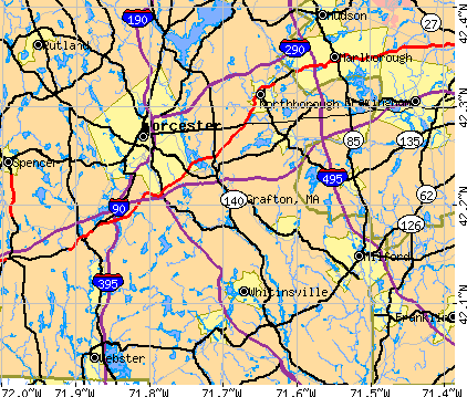
Points of interest:
Notable locations in Grafton: Grafton Station (A), Grafton Fire Department (B), Webster Veterinary Medical Library (C), Willard House and Clock Museum (D). Display/hide their locations on the map
Churches in Grafton include: Union Congregational Church (A), Saint Phillips Church (B), Saint Marys Church (C), Saint James Parish Center (D), Saint Andrews Episcopal Church (E), North Grafton United Methodist Church (F), Baptist Church of Grafton (G). Display/hide their locations on the map
Cemeteries: Saint Phillips Cemetery (1), Riverside Cemetery (2), Pine Grove Cemetery (3), Fairview Cemetery (4). Display/hide their locations on the map
Lakes and reservoirs: Windle Pond (A), Cider Millpond (B), Blackstone River Reservoir (C), Silver Lake (D), Lake Ripple (E), Pratts Pond (F), Hovey Pond (G), Hayes Pond (H). Display/hide their locations on the map
Streams, rivers, and creeks: Axtell Brook (A), Big Bummet Brook (B), Cronin Brook (C), Miscoe Brook (D), Quinsigamond River (E). Display/hide their locations on the map
Park in Grafton: John H Chafee Blackstone River Valley National Heritage Corridor (1). Display/hide its location on the map
Beach: Point Rok Beach (A). Display/hide its location on the map
Tourist attractions: Grafton Town - Public Libraries- Center (Cultural Attractions- Events- & Facilities; 33 Central Square), Grafton Town - Public Libraries- S Grafton BR (Cultural Attractions- Events- & Facilities; 71 Main), Grafton Recreation Commission (Amusement & Theme Parks; 101 Old Upton Road).
Birthplace of: Aaron Willard - Clockmaker, Cyrus Pitt Grosvenor - Anti-Slavery Baptist minister, Marnie Reed Crowell - Conservationist, Ryan Lannon - Ice hockey player, George Wheeler (explorer) - Cartographer, Holly Piirainen - Children, Asa Stratton - Major League Baseball player, Hugh Bradley (baseball) - Baseball player.
Drinking water stations with addresses in Grafton and their reported violations in the past:
GRAFTON WATER DISTRICT (Address: 44 MILLBURY ST. , Population served: 10,703, Groundwater):Past health violations:Past monitoring violations:
- MCL, Monthly (TCR) - In NOV-2012, Contaminant: Coliform. Follow-up actions: St AO (w/o penalty) issued (JAN-08-2013), St Compliance achieved (JAN-08-2013)
- Monitoring and Reporting (DBP) - Between JAN-2006 and DEC-2006, Contaminant: TTHM. Follow-up actions: St AO (w/o penalty) issued (DEC-12-2006), St Compliance achieved (SEP-10-2007)
- Monitoring and Reporting (DBP) - Between JAN-2006 and DEC-2006, Contaminant: Total Haloacetic Acids (HAA5). Follow-up actions: St AO (w/o penalty) issued (DEC-12-2006), St Compliance achieved (SEP-10-2007)
- One minor monitoring violation
- 4 regular monitoring violations
| This town: | 2.6 people |
| Massachusetts: | 2.5 people |
| This town: | 68.7% |
| Whole state: | 63.0% |
| This town: | 6.8% |
| Whole state: | 7.0% |
Likely homosexual households (counted as self-reported same-sex unmarried-partner households)
- Lesbian couples: 0.5% of all households
- Gay men: 0.2% of all households
| This town: | 5.6% |
| Whole state: | 9.3% |
| This town: | 3.0% |
| Whole state: | 4.4% |
People in group quarters in Grafton in 2010:
- 72 people in group homes intended for adults
- 11 people in correctional facilities intended for juveniles
- 4 people in college/university student housing
- 3 people in in-patient hospice facilities
People in group quarters in Grafton in 2000:
- 294 people in job corps and vocational training facilities
- 91 people in nursing homes
- 23 people in unknown juvenile institutions
- 16 people in short-term care, detention or diagnostic centers for delinquent children
- 12 people in homes for abused, dependent, and neglected children
- 4 people in homes for the physically handicapped
Banks with branches in Grafton (2011 data):
- Savers Co-operative Bank: Grafton Branch at 96 Worcester Street, branch established on 1976/05/01. Info updated 2011/08/19: Bank assets: $414.6 mil, Deposits: $307.9 mil, headquarters in Southbridge, MA, positive income, Mortgage Lending Specialization, 6 total offices
- Sovereign Bank, National Association: Grafton Branch at 76-78 Worcester Road, branch established on 1960/08/29. Info updated 2012/01/31: Bank assets: $78,146.9 mil, Deposits: $48,042.9 mil, headquarters in Wilmington, DE, positive income, Commercial Lending Specialization, 718 total offices, Holding Company: Banco Santander, S.A.
For population 15 years and over in Grafton:
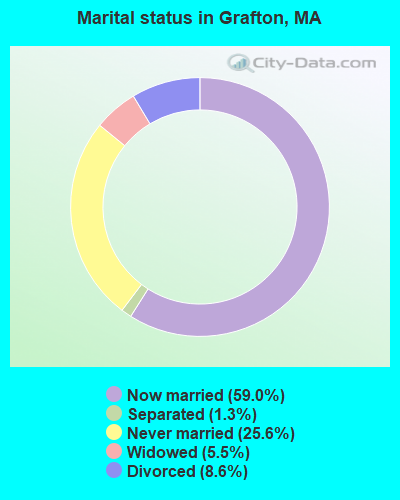
- Never married: 25.6%
- Now married: 59.0%
- Separated: 1.3%
- Widowed: 5.5%
- Divorced: 8.6%
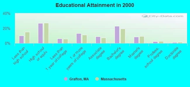
For population 25 years and over in Grafton:
- High school or higher: 89.9%
- Bachelor's degree or higher: 34.8%
- Graduate or professional degree: 11.8%
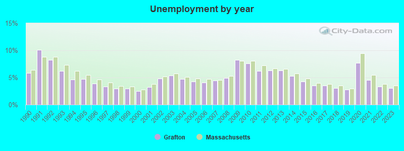
- Unemployed: 3.0%
- Mean travel time to work (commute): 28.2 minutes
| Here: | 10.6 |
| Massachusetts average: | 13.1 |


Graphs represent county-level data. Detailed 2008 Election Results
Religion statistics for Grafton, MA (based on Worcester County data)


| Religion | Adherents | Congregations |
|---|---|---|
| Catholic | 306,925 | 118 |
| Mainline Protestant | 43,326 | 171 |
| Evangelical Protestant | 37,511 | 203 |
| Other | 18,931 | 69 |
| Orthodox | 7,935 | 15 |
| Black Protestant | 497 | 6 |
| None | 383,427 | - |
Food Environment Statistics:
| Worcester County: | 1.73 / 10,000 pop. |
| Massachusetts: | 1.98 / 10,000 pop. |
| Worcester County: | 0.05 / 10,000 pop. |
| Massachusetts: | 0.05 / 10,000 pop. |
| This county: | 1.79 / 10,000 pop. |
| Massachusetts: | 2.22 / 10,000 pop. |
| Worcester County: | 2.22 / 10,000 pop. |
| Massachusetts: | 1.77 / 10,000 pop. |
| Worcester County: | 7.27 / 10,000 pop. |
| State: | 8.76 / 10,000 pop. |
| This county: | 8.0% |
| State: | 8.1% |
| Here: | 24.0% |
| Massachusetts: | 22.5% |
| Here: | 16.6% |
| Massachusetts: | 16.5% |
4.71% of this county's 2021 resident taxpayers lived in other counties in 2020 ($76,229 average adjusted gross income)
| Here: | 4.71% |
| Massachusetts average: | 6.35% |
0.02% of residents moved from foreign countries ($100 average AGI)
Worcester County: 0.02% Massachusetts average: 0.01%
Top counties from which taxpayers relocated into this county between 2020 and 2021:
| from Middlesex County, MA | |
| from Norfolk County, MA | |
| from Suffolk County, MA |
4.84% of this county's 2020 resident taxpayers moved to other counties in 2021 ($87,252 average adjusted gross income)
| Here: | 4.84% |
| Massachusetts average: | 7.18% |
0.03% of residents moved to foreign countries ($199 average AGI)
Worcester County: 0.03% Massachusetts average: 0.02%
Top counties to which taxpayers relocated from this county between 2020 and 2021:
| to Middlesex County, MA | |
| to Norfolk County, MA | |
| to Suffolk County, MA |
| Businesses in Grafton, MA | ||||
| Name | Count | Name | Count | |
|---|---|---|---|---|
| CVS | 1 | Subway | 1 | |
| Dunkin Donuts | 1 | UPS | 1 | |
| Stop & Shop | 1 | |||
Strongest AM radio stations in Grafton:
- WCRN (830 AM; 50 kW; WORCESTER, MA; Owner: CARTER BROADCASTING CORPORATION)
- WKOX (1200 AM; 50 kW; FRAMINGHAM, MA; Owner: CAPSTAR TX LIMITED PARTNERSHIP)
- WBIX (1060 AM; 40 kW; NATICK, MA; Owner: LANGER BROADCASTING CORPORATION)
- WALE (990 AM; 50 kW; GREENVILLE, RI; Owner: NORTH AMERICAN BROADCASTING CO., INC.)
- WAMG (890 AM; 25 kW; DEDHAM, MA; Owner: MEGA COMMUNICATIONS OF DEDHAM LICENSEE, LLC)
- WEEI (850 AM; 50 kW; BOSTON, MA; Owner: ENTERCOM BOSTON LICENSE, LLC)
- WORC (1310 AM; 5 kW; WORCESTER, MA; Owner: CHOWDER BROADCAST GROUP LLC)
- WVNE (760 AM; daytime; 25 kW; LEICESTER, MA; Owner: BLOUNT MASSCOM, INC.)
- WRKO (680 AM; 50 kW; BOSTON, MA; Owner: ENTERCOM BOSTON LICENSE, LLC)
- WTAG (580 AM; 5 kW; WORCESTER, MA; Owner: CAPSTAR TX LIMITED PARTNERSHIP)
- WWZN (1510 AM; 50 kW; BOSTON, MA; Owner: ROSE CITY RADIO CORPORATION)
- WVEI (1440 AM; 5 kW; WORCESTER, MA; Owner: ENTERCOM BOSTON LICENSE, LLC)
- WRCA (1330 AM; 25 kW; WALTHAM, MA; Owner: WRCA LICENSE, LLC)
Strongest FM radio stations in Grafton:
- WICN (90.5 FM; WORCESTER, MA; Owner: WICN PUBLIC RADIO, INC)
- WAAF (107.3 FM; WORCESTER, MA; Owner: ENTERCOM BOSTON LICENSE, LLC)
- WSRS (96.1 FM; WORCESTER, MA; Owner: CAPSTAR TX LIMITED PARTNERSHIP)
- WBMX (98.5 FM; BOSTON, MA; Owner: INFINITY RADIO OPERATIONS INC.)
- WJMN (94.5 FM; BOSTON, MA; Owner: AMFM RADIO LICENSES, L.L.C.)
- WCRB (102.5 FM; WALTHAM, MA; Owner: CHARLES RIVER BROADCASTING WCRB LICE)
- WTKK (96.9 FM; BOSTON, MA; Owner: GREATER BOSTON RADIO, INC.)
- WROR-FM (105.7 FM; FRAMINGHAM, MA; Owner: GREATER BOSTON RADIO, INC.)
- WBOS (92.9 FM; BROOKLINE, MA; Owner: GREATER BOSTON RADIO, INC.)
- WGBH (89.7 FM; BOSTON, MA; Owner: WGBH EDUCATIONAL FOUNDATION)
- WBUR-FM (90.9 FM; BOSTON, MA; Owner: TRUSTEES OF BOSTON UNIVERSITY)
- WODS (103.3 FM; BOSTON, MA; Owner: INFINITY BROADCASTING OPERATIONS, INC.)
- WCUW (91.3 FM; WORCESTER, MA; Owner: WUW, INC.)
- WXKS-FM (107.9 FM; MEDFORD, MA; Owner: AMFM RADIO LICENSES, L.L.C.)
- WXLO (104.5 FM; FITCHBURG, MA; Owner: CITADEL BROADCASTING COMPANY)
- WYCM (90.1 FM; CHARLTON, MA; Owner: BAY PATH VOCATIONAL HIGH SCHOOL)
- WMJX (106.7 FM; BOSTON, MA; Owner: GREATER BOSTON RADIO, INC.)
- WWKX (106.3 FM; WOONSOCKET, RI; Owner: AAA ENTERTAINMENT LICENSING LLC)
- WWBB (101.5 FM; PROVIDENCE, RI; Owner: CLEAR CHANNEL BROADCASTING LICENSES, INC.)
- WWFX (100.1 FM; SOUTHBRIDGE, MA; Owner: CITADEL BROADCASTING COMPANY)
TV broadcast stations around Grafton:
- WUNI (Channel 27; WORCESTER, MA; Owner: ENTRAVISION HOLDINGS, LLC)
- WUTF (Channel 66; MARLBOROUGH, MA; Owner: TELEFUTURA BOSTON LLC)
- WCVB-TV (Channel 5; BOSTON, MA; Owner: WCVB HEARST-ARGYLE TV, INC.)
- WGBH-TV (Channel 2; BOSTON, MA; Owner: WGBH EDUCATIONAL FOUNDATION)
- WMFP (Channel 62; LAWRENCE, MA; Owner: WSAH LICENSE, INC.)
- WHDH-TV (Channel 7; BOSTON, MA; Owner: WHDH-TV)
- WBZ-TV (Channel 4; BOSTON, MA; Owner: VIACOM INC.)
- WGBX-TV (Channel 44; BOSTON, MA; Owner: WGBH EDUCATIONAL FOUNDATION)
- WSBK-TV (Channel 38; BOSTON, MA; Owner: VIACOM INC.)
- WLVI-TV (Channel 56; CAMBRIDGE, MA; Owner: WLVI, INC.)
- WFXT (Channel 25; BOSTON, MA; Owner: FOX TELEVISION STATIONS INC.)
- WYDN (Channel 48; WORCESTER, MA; Owner: EDUCATIONAL PUBLIC TV CORPORATION)
- WCRN-LP (Channel 34; LEICESTER, MA; Owner: CARTER BROADCASTING CORPORATION)
- W40BO (Channel 40; BOSTON, MA; Owner: PAXSON COMMUNICATIONS LPTV, INC.)
- WPXQ (Channel 69; BLOCK ISLAND, RI; Owner: OCEAN STATE TELEVISION, L.L.C.)
- WNAC-TV (Channel 64; PROVIDENCE, RI; Owner: WNAC, LLC)
- WBPX (Channel 68; BOSTON, MA; Owner: PAXSON BOSTON-68 LICENSE, INC.)
- WPRI-TV (Channel 12; PROVIDENCE, RI; Owner: TVL BROADCASTING OF RHODE ISLAND, LLC)
- WLNE-TV (Channel 6; NEW BEDFORD, MA; Owner: FREEDOM BROADCASTING OF SOUTHERN NEW ENGLAND, INC.)
- WWDP (Channel 46; NORWELL, MA; Owner: NORWELL TELEVISION, LLC)
- WJAR (Channel 10; PROVIDENCE, RI; Owner: OUTLET BROADCASTING, INC.)
- WTMU-LP (Channel 32; BOSTON, MA; Owner: ZGS BOSTON, INC.)
- WCEA-LP (Channel 58; BOSTON, MA; Owner: CHANNEL 19 TV CORPORATION)
- WSBE-TV (Channel 36; PROVIDENCE, RI; Owner: RHODE ISLAND PUBLIC TELECOM. AUTHORITY)
- WRIW-LP (Channel 50; PROVIDENCE, RI; Owner: ZGS PROVIDENCE, INC.)
Medal of Honor Recipients
Medal of Honor Recipient born in Grafton: Charles H. Pinkham.
- National Bridge Inventory (NBI) Statistics
- 34Number of bridges
- 249ft / 76.1mTotal length
- $52,044,000Total costs
- 732,902Total average daily traffic
- 67,048Total average daily truck traffic
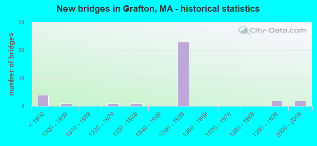
- New bridges - historical statistics
- 4Before 1900
- 11900-1909
- 11920-1929
- 11930-1939
- 231950-1959
- 21990-1999
- 22000-2009
FCC Registered Antenna Towers:
30 (See the full list of FCC Registered Antenna Towers in Grafton)FCC Registered Broadcast Land Mobile Towers:
2- 44 Worcester St (Lat: 42.211750 Lon: -71.688111), Type: Tower, Structure height: 67 m, Call Sign: WQHU395,
Assigned Frequencies: 47.3600 MHz, Grant Date: 11/07/2007, Expiration Date: 11/07/2017, Cancellation Date: 01/13/2018, Certifier: Richie Maloney, Registrant: Massachusetts, Commonwealth Of, 10 Park Plz Rm 7210, Boston, MA 02116-3973, Phone: (617) 973-7049, Fax: (617) 248-3869
- Lat: 42.206889 Lon: -71.686111, Call Sign: WQRV697,
Assigned Frequencies: 457.112 MHz, 457.412 MHz, 457.637 MHz, 467.512 MHz, Grant Date: 08/02/2013, Expiration Date: 08/02/2023, Cancellation Date: 10/07/2023, Certifier: Anthony Lemay, Registrant: Worad, Inc., 299 Brooks Street, Worcester, MA 01606, Phone: (508) 852-2693, Fax: (508) 852-2704, Email:
FCC Registered Microwave Towers:
5- BOS1229, 20 Indian Path (Lat: 42.228611 Lon: -71.690278), Type: Pole, Structure height: 25.9 m, Call Sign: WQFL201,
Assigned Frequencies: 19360.0 MHz, Grant Date: 08/08/2006, Expiration Date: 08/08/2016, Cancellation Date: 02/26/2008, Certifier: Eric M Botto, Registrant: Fibertower Corporation, 1730 Rhode Island Avenue N.W., Suite 317, Washington, DC 20036, Phone: (703) 873-4175, Fax: (202) 315-3415, Email:
- BOS1230, Knowlton Dairy Estabrook Rd (Lat: 42.226667 Lon: -71.663889), Type: Tower, Structure height: 31 m, Call Sign: WQGF989, Licensee ID: L01728370,
Assigned Frequencies: 19540.0 MHz, Grant Date: 01/08/2007, Expiration Date: 01/08/2017, Cancellation Date: 09/09/2013, Certifier: Joseph M Sandri Jr., Registrant: Fibertower Network Services, Corp., Debtor-In-Possession, 1875 Eye Street, Nw, 5th Floor, Room 505, Washington, DC 20006, Phone: (202) 223-1028, Email:
- GRAFTON, 244 Worcester Street (Lat: 42.234028 Lon: -71.726389), Type: Tower, Structure height: 33.2 m, Overall height: 36.9 m, Call Sign: WQUB362,
Assigned Frequencies: 19440.0 MHz, Grant Date: 05/27/2014, Expiration Date: 05/27/2024, Cancellation Date: 09/17/2015, Certifier: John E Monday, Registrant: At&t Mobility LLC, 3300 E. Renner Road #b3132, Richardson, TX 75082, Phone: (855) 699-7073, Fax: (972) 907-1131, Email:
- GRAFTON, 244 Worcester Street (Lat: 42.234028 Lon: -71.726389), Type: Tower, Structure height: 33.2 m, Overall height: 36.9 m, Call Sign: WQXA201,
Assigned Frequencies: 19440.0 MHz, Grant Date: 01/11/2016, Expiration Date: 01/11/2026, Certifier: John E Monday, Registrant: At&t Services, Inc., 208 S Akard St, 20f, Dallas, TX 75202, Phone: (855) 699-7073, Fax: (214) 746-6410, Email:
- STATION, Grafton State Police Barracks (Lat: 42.211750 Lon: -71.688111), Overall height: 67.1 m, Call Sign: WCE899,
Assigned Frequencies: 959.100 MHz, Grant Date: 06/30/2018, Expiration Date: 07/31/2028, Registrant: Commonwealth Of Massachusetts, Department Of Transportation, 10 Park Plaza Rm 7410, Boston, MA 02116, Phone: (857) 452-9600, Email:
FCC Registered Amateur Radio Licenses:
23 (See the full list of FCC Registered Amateur Radio Licenses in Grafton)FAA Registered Aircraft:
5- Aircraft: MISTERKA ROBERT M COZY 3 PLACE (Category: Land, Seats: 3, Weight: Up to 12,499 Pounds), Engine: LYCOMING O-320-E3D (150 HP) (Reciprocating)
N-Number: 342RM, N342RM, N-342RM, Serial Number: 446, Year manufactured: 1996, Airworthiness Date: 11/21/2006, Certificate Issue Date: 08/17/1998
Registrant (Individual): Robert M Trustee Misterka, 11 Cheryl Dr, Grafton, MA 01519 - Aircraft: SCHWEIZER SGS 1-26C (Category: Land, Weight: Up to 12,499 Pounds, Speed: 58 mph), Engine: None
N-Number: 5702S, N5702S, N-5702S, Serial Number: 380, Year manufactured: 1970, Airworthiness Date: 04/15/1971, Certificate Issue Date: 09/13/2017
Registrant (Individual): Scott B Lamont, 25 Trinity Ave, Grafton, MA 01519 - Aircraft: CESSNA 172N (Category: Land, Seats: 4, Weight: Up to 12,499 Pounds, Speed: 105 mph), Engine: LYCOMING 0-320 SERIES (180 HP) (Reciprocating)
N-Number: 75799, N75799, N-75799, Serial Number: 17267959, Year manufactured: 1976, Airworthiness Date: 10/12/1976, Certificate Issue Date: 08/04/1997
Registrant (Co-Owned): Peter M Allia, 9 Powerline Dr, Grafton, MA 01519, Other Owners: Kenneth A Poole - Aircraft: SCHWEIZER SGS 1-35C (Category: Land, Weight: Up to 12,499 Pounds, Speed: 105 mph), Engine: None
N-Number: 8100J, N8100J, N-8100J, Serial Number: 67, Certificate Issue Date: 07/20/2017
Registrant (Individual): Scott B Lamont, 25 Trinity Ave, Grafton, MA 01519
Deregistered: Cancel Date: 02/19/1999 - Aircraft: SAILPLANE HP-14 (Category: Land, Weight: Up to 12,499 Pounds, Speed: 60 mph), Engine: None
N-Number: 4400, N4400, N-4400, Serial Number: 57, Year manufactured: 1968, Airworthiness Date: 08/10/1977, Certificate Issue Date: 07/13/2009
Registrant (Individual): Scott B Lamont, 25 Trinity Ave, Grafton, MA 01519
2002 - 2018 National Fire Incident Reporting System (NFIRS) incidents
- Fire incident types reported to NFIRS in Grafton, MA
- 24767.3%Structure Fires
- 6417.4%Outside Fires
- 4913.4%Mobile Property/Vehicle Fires
- 71.9%Other
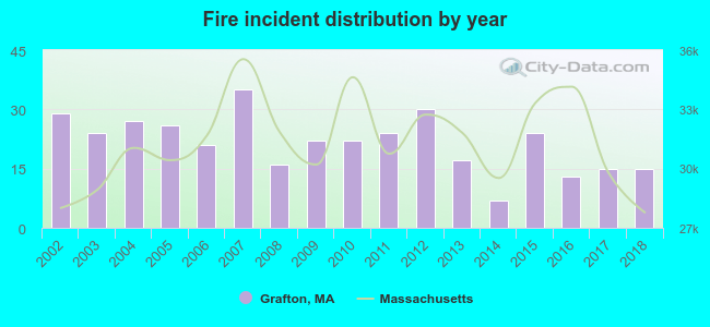 Based on the data from the years 2002 - 2018 the average number of fires per year is 22. The highest number of fire incidents - 35 took place in 2007, and the least - 7 in 2014. The data has a dropping trend.
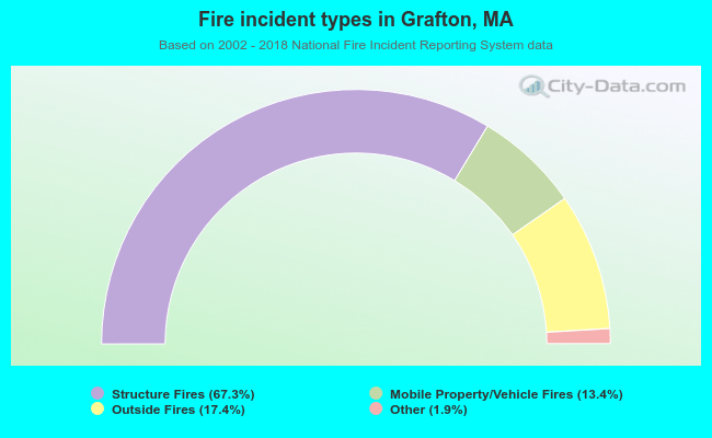 When looking into fire subcategories, the most incidents belonged to: Structure Fires (67.3%), and Outside Fires (17.4%).
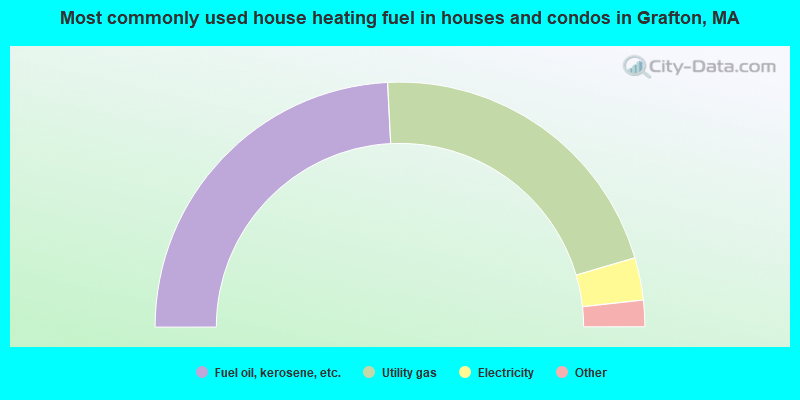
- 48.4%Fuel oil, kerosene, etc.
- 42.5%Utility gas
- 5.6%Electricity
- 2.0%Bottled, tank, or LP gas
- 1.1%Wood
- 0.2%No fuel used
- 0.1%Coal or coke
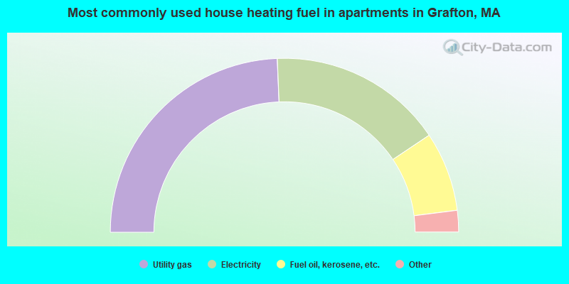
- 48.7%Utility gas
- 32.5%Electricity
- 14.8%Fuel oil, kerosene, etc.
- 2.5%Bottled, tank, or LP gas
- 1.0%Wood
- 0.4%No fuel used
Grafton compared to Massachusetts state average:
- Unemployed percentage significantly below state average.
- Black race population percentage significantly below state average.
- Hispanic race population percentage significantly below state average.
- Foreign-born population percentage significantly below state average.
- Renting percentage below state average.
- Length of stay since moving in significantly above state average.
- Number of rooms per house significantly below state average.
- House age significantly below state average.
Grafton on our top lists:
- #29 on the list of "Top 101 cities with largest percentage of females in industries: office supplies and stationery stores (population 5,000+)"
- #32 on the list of "Top 101 cities with largest percentage of females in industries: farm supplies merchant wholesalers (population 5,000+)"
- #34 on the list of "Top 101 cities with the largest percentage of people in job corps and vocational training facilities (population 1,000+)"
- #44 on the list of "Top 101 cities with largest percentage of females in occupations: other health diagnosing and treating practitioners and technical occupations (population 5,000+)"
- #48 on the list of "Top 101 cities with largest percentage of males in industries: nonmetallic mineral products (population 5,000+)"
- #57 on the list of "Top 101 cities with largest percentage of males in industries: miscellaneous manufacturing (population 5,000+)"
- #65 on the list of "Top 101 cities with largest percentage of males in occupations: accountants and auditors (population 5,000+)"
- #65 on the list of "Top 101 cities with largest percentage of males in industries: pharmacies and drug stores (population 5,000+)"
- #66 on the list of "Top 101 cities with largest percentage of males in industries: computer and electronic products (population 5,000+)"
- #69 on the list of "Top 101 cities with largest percentage of females in occupations: construction trades workers except carpenters, electricians, painters, plumbers, and construction laborers (population 5,000+)"
- #79 on the list of "Top 101 cities with largest percentage of males in occupations: advertising, marketing, promotions, public relations, and sales managers (population 5,000+)"
- #89 on the list of "Top 101 cities with the lowest number of thefts per 100,000 residents (population 5,000+)"
- #95 on the list of "Top 101 cities with largest percentage of females in occupations: mathematical science occupations (population 5,000+)"
- #101 on the list of "Top 101 cities with largest percentage of females in occupations: carpenters (population 5,000+)"
- #4 on the list of "Top 101 counties with the highest carbon monoxide air pollution readings in 2012 (ppm)"
- #5 on the list of "Top 101 counties with the most Catholic congregations"
- #12 on the list of "Top 101 counties with the highest surface withdrawal of fresh water for public supply"
- #16 on the list of "Top 101 counties with the highest total withdrawal of fresh water for public supply"
- #23 on the list of "Top 101 counties with the highest Sulfur Oxides Annual air pollution readings in 2012 (µg/m3)"

|
|
Total of 398 patent applications in 2008-2024.