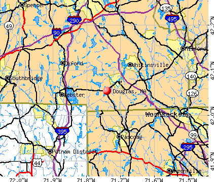
Douglas, Massachusetts
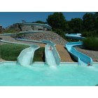
Douglas: Breezy Picnic Area, Douglas Water Slides
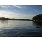
Douglas: On Kings River in Douglas.
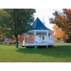
Douglas: Old Douglas Common
- add
your
Submit your own pictures of this town and show them to the world
- OSM Map
- General Map
- Google Map
- MSN Map
Population change since 2000: +20.2%
| Males: 4,215 | |
| Females: 4,256 |
| Median resident age: | 39.3 years |
| Massachusetts median age: | 39.2 years |
Zip codes: 01516.
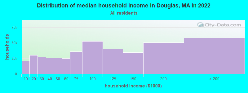
| Douglas: | $109,059 |
| MA: | $94,488 |
Estimated per capita income in 2022: $44,915 (it was $23,036 in 2000)
Douglas town income, earnings, and wages data
Estimated median house or condo value in 2022: $422,520 (it was $153,000 in 2000)
| Douglas: | $422,520 |
| MA: | $534,700 |
Mean prices in 2022: all housing units: $419,164; detached houses: $447,621; townhouses or other attached units: $343,592; in 2-unit structures: $323,295; in 3-to-4-unit structures: $332,295; in 5-or-more-unit structures: $232,758; mobile homes: $113,885
Detailed information about poverty and poor residents in Douglas, MA
Compare current foreclosures near Douglas, MA:
| Photo | Address | Area | Beds / Baths | Price | Details |
|---|---|---|---|---|---|

|
#1
Sunset Dr
Douglas, MA 01516
|
1,613 sq. feet
|
1 baths 3 beds |
show details | |

|
#2
South St
Douglas, MA 01516
|
1,685 sq. feet
|
1 baths 3 beds |
show details | |

|
#3
Brandy Wine Cir
Douglas, MA 01516
|
1,844 sq. feet
|
1 baths 3 beds |
show details | |

|
#4
West St Apt 215
Douglas, MA 01516
|
- sq. feet
|
- baths - beds |
show details | |

|
#5
Cook Rd
Cumberland, RI 02864
|
2,050 sq. feet
|
2 baths 4 beds |
$749,500
|
show details |

|
#6
Round Lake Dr
Pascoag, RI 02859
|
976 sq. feet
|
2 baths 2 beds |
$179,900
|
show details |

|
#7
Mount Pleasant Rd
Harrisville, RI 02830
|
1,232 sq. feet
|
1 baths 3 beds |
$449,900
|
show details |

|
#8
Clarence Dr
Oxford, MA 01540
|
3,010 sq. feet
|
3 baths 5 beds |
$569,900
|
show details |

|
#9
Randolph St
Southbridge, MA 01550
|
3,276 sq. feet
|
3 baths 9 beds |
show details | |

|
#10
Eastern Ave
Worcester, MA 01605
|
1,736 sq. feet
|
3 baths 6 beds |
show details |
| Photo | Address | Area | Beds / Baths | Price | Details |
|---|---|---|---|---|---|

|
#11
Laurelwood Dr # No
Hopedale, MA 01747
|
1,440 sq. feet
|
1 baths 2 beds |
show details | |

|
#12
Elm St
Webster, MA 01570
|
1,197 sq. feet
|
1 baths 3 beds |
show details | |

|
#13
Hawkins St
Worcester, MA 01604
|
864 sq. feet
|
1 baths 3 beds |
show details | |

|
#14
Ramshorn Rd
Dudley, MA 01571
|
3,336 sq. feet
|
1 baths 5 beds |
show details | |

|
#15
Mendon St
Blackstone, MA 01504
|
2,312 sq. feet
|
2 baths 4 beds |
show details | |

|
#16
Pine St
Dudley, MA 01571
|
1,414 sq. feet
|
2 baths 4 beds |
show details | |

|
#17
N Main St
Pascoag, RI 02859
|
- sq. feet
|
- baths - beds |
$100,000
|
show details |

|
#18
Cedar St
Ashland, MA 01721
|
2,756 sq. feet
|
3 baths 4 beds |
show details | |

|
#19
Everett Cir
Hopkinton, MA 01748
|
5,180 sq. feet
|
3 baths 4 beds |
show details | |

|
#20
Richards St
Worcester, MA 01603
|
1,144 sq. feet
|
1 baths 3 beds |
show details |
| Photo | Address | Area | Beds / Baths | Price | Details |
|---|---|---|---|---|---|

|
#21
Leicester St
Auburn, MA 01501
|
912 sq. feet
|
1 baths 2 beds |
show details | |

|
#22
Round Top Rd
Harrisville, RI 02830
|
1,280 sq. feet
|
1 baths 3 beds |
show details | |

|
#23
Lena Lane Unit 1, 25-27 Lena Lane Condominium
Milford, MA 01757
|
990 sq. feet
|
1 baths 2 beds |
show details | |

|
#24
Greenwood St
Worcester, MA 01607
|
1,337 sq. feet
|
1 baths 3 beds |
show details | |

|
#25
Paine District Rd
Woodstock, CT 06281
|
1,092 sq. feet
|
1 baths 2 beds |
show details | |

|
#26
Mallard Dr
Medway, MA 02053
|
2,024 sq. feet
|
2 baths 5 beds |
show details | |

|
#27
1/2 Putnam Hill Road
Sutton, MA 01590
|
1,415 sq. feet
|
1 baths 3 beds |
show details | |

|
#28
Woodstock Avenu
Putnam, CT 06260
|
4,281 sq. feet
|
2 baths 6 beds |
show details | |

|
#29
Sunderland Rd
Worcester, MA 01604
|
2,574 sq. feet
|
2 baths 4 beds |
show details | |

|
#30
Logee St
Woonsocket, RI 02895
|
1,270 sq. feet
|
1 baths 4 beds |
show details |
| Photo | Address | Area | Beds / Baths | Price | Details |
|---|---|---|---|---|---|

|
#31
Pineview Trl
Auburn, MA 01501
|
791 sq. feet
|
1 baths 4 beds |
show details | |

|
#32
Bertenshaw Rd
Woonsocket, RI 02895
|
1,512 sq. feet
|
2 baths 4 beds |
show details | |

|
#33
Hayden Rowe St
Hopkinton, MA 01748
|
1,336 sq. feet
|
1 baths 2 beds |
show details | |

|
#34
Preston Ave
Auburn, MA 01501
|
1,054 sq. feet
|
1 baths 3 beds |
show details | |

|
#35
Rhode Island Ave
Woonsocket, RI 02895
|
2,080 sq. feet
|
2 baths 6 beds |
show details | |

|
#36
Sunset Dr
Milford, MA 01757
|
1,104 sq. feet
|
1 baths 3 beds |
show details | |

|
#37
Crestlan Dr
Worcester, MA 01604
|
1,365 sq. feet
|
1 baths 3 beds |
show details | |

|
#38
Purchase St
Milford, MA 01757
|
1,934 sq. feet
|
1 baths 3 beds |
show details | |

|
#39
Muggett Hill Rd
Charlton, MA 01507
|
2,728 sq. feet
|
2 baths 3 beds |
show details | |

|
#40
Ravine Dr
Auburn, MA 01501
|
872 sq. feet
|
1 baths 2 beds |
show details |
| Photo | Address | Area | Beds / Baths | Price | Details |
|---|---|---|---|---|---|

|
#41
Loxwood St
Worcester, MA 01604
|
1,026 sq. feet
|
1 baths 2 beds |
show details | |

|
#42
Westwood Dr
Auburn, MA 01501
|
1,078 sq. feet
|
1 baths 3 beds |
show details | |

|
#43
Briar Dr
Milford, MA 01757
|
1,900 sq. feet
|
2 baths 4 beds |
show details | |

|
#44
Douglas Cir
Greenville, RI 02828
|
960 sq. feet
|
1 baths 3 beds |
show details | |

|
#45
Lena Ln # 25
Milford, MA 01757
|
990 sq. feet
|
1 baths 2 beds |
show details | |

|
#46
Lena Ln # 1
Milford, MA 01757
|
990 sq. feet
|
1 baths 2 beds |
show details | |

|
#47
Vandale St
Putnam, CT 06260
|
1,671 sq. feet
|
3 baths 3 beds |
show details | |

|
#48
Greencourt St
Worcester, MA 01604
|
984 sq. feet
|
1 baths 3 beds |
show details | |

|
#49
S Edlin St
Worcester, MA 01603
|
1,408 sq. feet
|
1 baths 3 beds |
show details | |

|
Check over 1 million property listings on Foreclosure.com!
|
browse all offers | |||

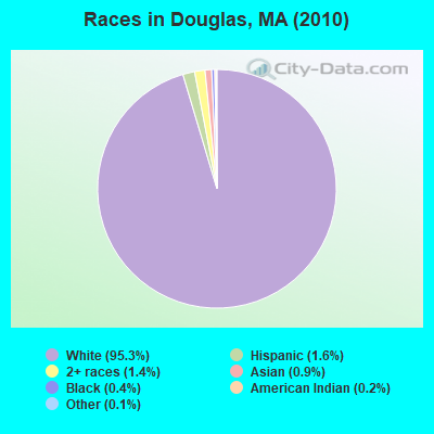
- 8,07495.3%White alone
- 1391.6%Hispanic
- 1221.4%Two or more races
- 750.9%Asian alone
- 350.4%Black alone
- 140.2%American Indian alone
- 90.1%Other race alone
- 30.04%Native Hawaiian and Other
Pacific Islander alone
Races in Douglas detailed stats: ancestries, foreign born residents, place of birth
According to our research of Massachusetts and other state lists, there were 2 registered sex offenders living in Douglas, Massachusetts as of May 07, 2024.
The ratio of all residents to sex offenders in Douglas is 4,236 to 1.
The ratio of registered sex offenders to all residents in this city is much lower than the state average.
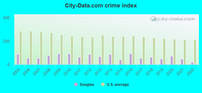
Type |
2009 |
2010 |
2011 |
2012 |
2013 |
2014 |
2015 |
2016 |
2017 |
2018 |
2019 |
2020 |
2021 |
2022 |
|---|---|---|---|---|---|---|---|---|---|---|---|---|---|---|
| Murders (per 100,000) | 0 (0.0) | 0 (0.0) | 0 (0.0) | 0 (0.0) | 0 (0.0) | 0 (0.0) | 0 (0.0) | 0 (0.0) | 0 (0.0) | 0 (0.0) | 0 (0.0) | 0 (0.0) | 0 (0.0) | 0 (0.0) |
| Rapes (per 100,000) | 2 (24.7) | 3 (35.4) | 0 (0.0) | 4 (46.6) | 1 (11.6) | 2 (23.0) | 0 (0.0) | 6 (68.6) | 0 (0.0) | 1 (11.2) | 2 (22.4) | 4 (44.2) | 3 (32.4) | 0 (0.0) |
| Robberies (per 100,000) | 0 (0.0) | 0 (0.0) | 0 (0.0) | 0 (0.0) | 0 (0.0) | 0 (0.0) | 0 (0.0) | 0 (0.0) | 0 (0.0) | 1 (11.2) | 1 (11.2) | 0 (0.0) | 0 (0.0) | 0 (0.0) |
| Assaults (per 100,000) | 18 (222.4) | 7 (82.6) | 11 (129.1) | 7 (81.6) | 9 (104.3) | 15 (172.7) | 6 (68.7) | 6 (68.6) | 14 (159.2) | 18 (201.7) | 5 (55.9) | 10 (110.4) | 5 (54.0) | 4 (43.7) |
| Burglaries (per 100,000) | 18 (222.4) | 39 (460.4) | 26 (305.1) | 25 (291.5) | 33 (382.5) | 24 (276.3) | 18 (206.0) | 5 (57.2) | 12 (136.4) | 4 (44.8) | 6 (67.1) | 7 (77.3) | 6 (64.8) | 6 (65.6) |
| Thefts (per 100,000) | 22 (271.8) | 26 (306.9) | 35 (410.7) | 23 (268.2) | 21 (243.4) | 28 (322.3) | 25 (286.1) | 28 (320.3) | 29 (329.7) | 14 (156.9) | 15 (167.7) | 18 (198.8) | 7 (75.6) | 12 (131.2) |
| Auto thefts (per 100,000) | 1 (12.4) | 4 (47.2) | 2 (23.5) | 2 (23.3) | 4 (46.4) | 3 (34.5) | 3 (34.3) | 9 (103.0) | 1 (11.4) | 2 (22.4) | 3 (33.5) | 3 (33.1) | 5 (54.0) | 2 (21.9) |
| Arson (per 100,000) | 0 (0.0) | 0 (0.0) | 0 (0.0) | 1 (11.7) | 0 (0.0) | 0 (0.0) | 0 (0.0) | 0 (0.0) | 0 (0.0) | 0 (0.0) | 0 (0.0) | 0 (0.0) | 0 (0.0) | 0 (0.0) |
| City-Data.com crime index | 91.7 | 93.1 | 65.5 | 86.6 | 70.4 | 87.9 | 42.3 | 93.7 | 55.5 | 63.9 | 46.5 | 73.4 | 48.6 | 20.3 |
The City-Data.com crime index weighs serious crimes and violent crimes more heavily. Higher means more crime, U.S. average is 246.1. It adjusts for the number of visitors and daily workers commuting into cities.
Crime rate in Douglas detailed stats: murders, rapes, robberies, assaults, burglaries, thefts, arson
Full-time law enforcement employees in 2021, including police officers: 20 (15 officers - 14 male; 1 female).
| Officers per 1,000 residents here: | 1.62 |
| Massachusetts average: | 2.53 |
 Recent articles from our blog. Our writers, many of them Ph.D. graduates or candidates, create easy-to-read articles on a wide variety of topics.

 | How About Those Patriots? (1172 replies) |
| Mass migration: People continue to leave the state (143 replies) |
| Potentially Moving from Texas to Massachusetts. (130 replies) |
| Put Drivers Licenses for Illegal Aliens to a Vote? (244 replies) |
| Big MA Ancestry Data Thread by Town (31 replies) |
| Coronavirus in Massachusetts (18047 replies) |
Latest news from Douglas, MA collected exclusively by city-data.com from local newspapers, TV, and radio stations
Douglas, MA City Guides:
Ancestries: French (20.6%), Irish (20.5%), English (15.1%), French Canadian (12.8%), Italian (11.6%), Polish (9.4%).
Current Local Time: EST time zone
Incorporated in 1775
Elevation: 582 feet
Land area: 36.4 square miles.
Population density: 233 people per square mile (very low).
247 residents are foreign born (1.5% Europe, 1.0% Asia, 0.6% North America, 0.4% Africa).
| This town: | 3.5% |
| Massachusetts: | 12.2% |
| Douglas town: | 1.5% ($2,305) |
| Massachusetts: | 1.3% ($2,336) |
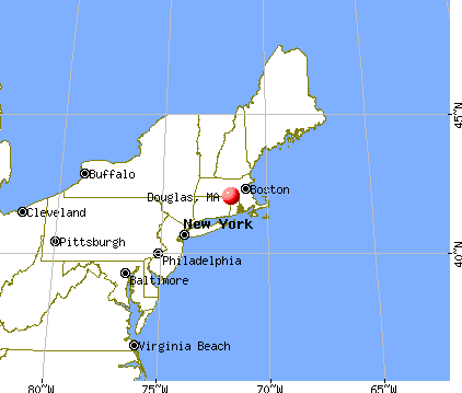
Nearest city with pop. 50,000+: Worcester, MA  (15.3 miles , pop. 172,648).
Nearest city with pop. 200,000+: Boston, MA (37.8 miles , pop. 589,141).
Nearest city with pop. 1,000,000+: Bronx, NY (138.9 miles , pop. 1,332,650).
Nearest cities:
), ), Latitude: 42.05 N, Longitude: 71.73 W

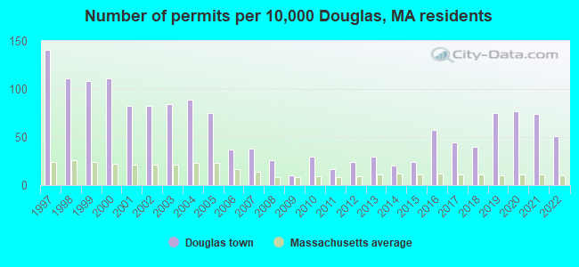
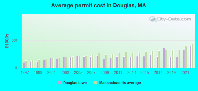
Single-family new house construction building permits:
- 2022: 36 buildings, average cost: $396,500
- 2021: 52 buildings, average cost: $327,900
- 2020: 54 buildings, average cost: $201,100
- 2019: 53 buildings, average cost: $201,100
- 2018: 28 buildings, average cost: $364,300
- 2017: 31 buildings, average cost: $203,200
- 2016: 40 buildings, average cost: $241,100
- 2015: 17 buildings, average cost: $209,600
- 2014: 14 buildings, average cost: $210,500
- 2013: 21 buildings, average cost: $201,400
- 2012: 17 buildings, average cost: $207,200
- 2011: 12 buildings, average cost: $207,300
- 2010: 21 buildings, average cost: $176,700
- 2009: 7 buildings, average cost: $160,600
- 2008: 18 buildings, average cost: $222,300
- 2007: 27 buildings, average cost: $206,100
- 2006: 26 buildings, average cost: $204,800
- 2005: 53 buildings, average cost: $218,100
- 2004: 63 buildings, average cost: $199,600
- 2003: 59 buildings, average cost: $196,700
- 2002: 58 buildings, average cost: $170,800
- 2001: 58 buildings, average cost: $177,100
- 2000: 78 buildings, average cost: $135,800
- 1999: 76 buildings, average cost: $117,000
- 1998: 78 buildings, average cost: $106,500
- 1997: 99 buildings, average cost: $99,800
| Here: | 3.1% |
| Massachusetts: | 3.5% |
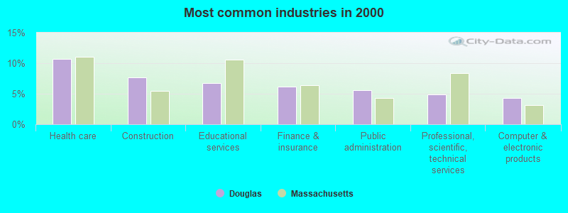
- Health care (10.8%)
- Construction (7.7%)
- Educational services (6.7%)
- Finance & insurance (6.1%)
- Public administration (5.5%)
- Professional, scientific, technical services (4.9%)
- Computer & electronic products (4.3%)
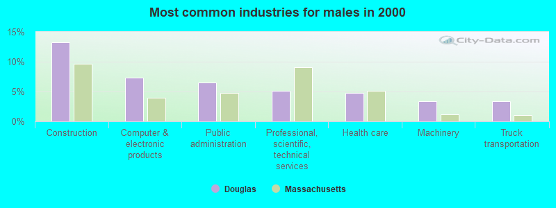
- Construction (13.3%)
- Computer & electronic products (7.3%)
- Public administration (6.5%)
- Professional, scientific, technical services (5.1%)
- Health care (4.8%)
- Machinery (3.4%)
- Truck transportation (3.3%)
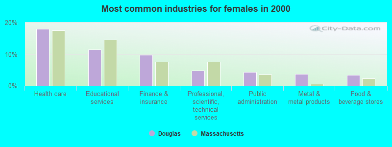
- Health care (17.9%)
- Educational services (11.4%)
- Finance & insurance (9.8%)
- Professional, scientific, technical services (4.8%)
- Public administration (4.4%)
- Metal & metal products (3.8%)
- Food & beverage stores (3.4%)
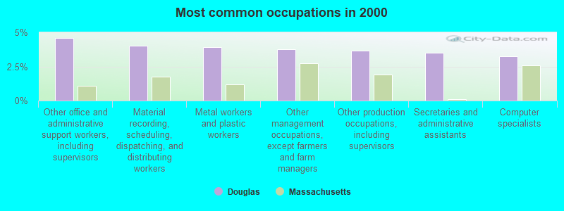
- Other office and administrative support workers, including supervisors (4.6%)
- Material recording, scheduling, dispatching, and distributing workers (4.0%)
- Metal workers and plastic workers (3.9%)
- Other management occupations, except farmers and farm managers (3.8%)
- Other production occupations, including supervisors (3.7%)
- Secretaries and administrative assistants (3.5%)
- Computer specialists (3.2%)
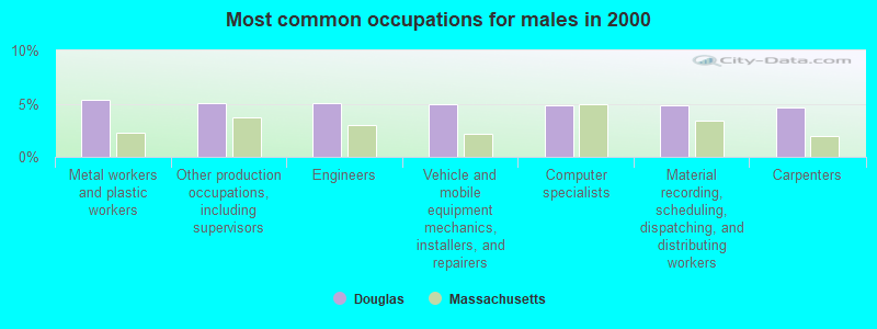
- Metal workers and plastic workers (5.3%)
- Other production occupations, including supervisors (5.1%)
- Engineers (5.0%)
- Vehicle and mobile equipment mechanics, installers, and repairers (5.0%)
- Computer specialists (4.9%)
- Material recording, scheduling, dispatching, and distributing workers (4.9%)
- Carpenters (4.7%)
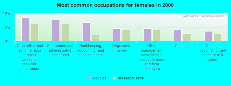
- Other office and administrative support workers, including supervisors (8.4%)
- Secretaries and administrative assistants (7.7%)
- Bookkeeping, accounting, and auditing clerks (6.7%)
- Registered nurses (4.6%)
- Other management occupations, except farmers and farm managers (4.5%)
- Cashiers (4.1%)
- Nursing, psychiatric, and home health aides (3.5%)
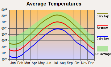
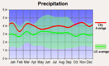
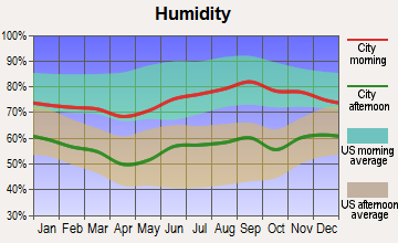
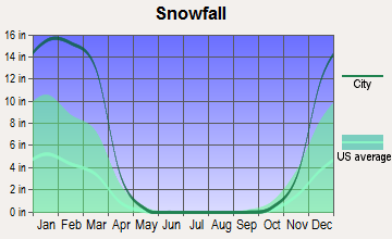
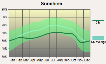
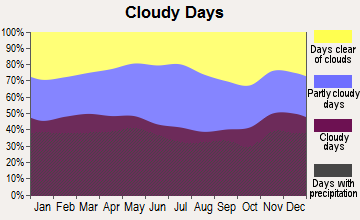
Average climate in Douglas, Massachusetts
Based on data reported by over 4,000 weather stations

(lower is better)
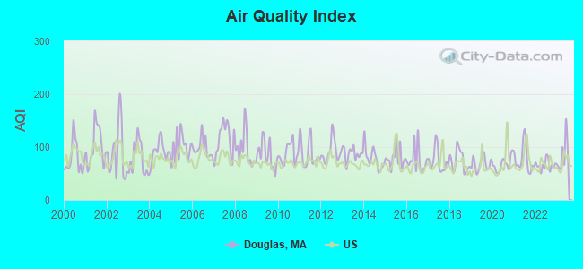
Air Quality Index (AQI) level in 2023 was 84.8. This is about average.
| City: | 84.8 |
| U.S.: | 72.6 |
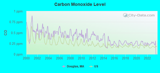
Carbon Monoxide (CO) [ppm] level in 2022 was 0.243. This is about average. Closest monitor was 14.5 miles away from the city center.
| City: | 0.243 |
| U.S.: | 0.251 |
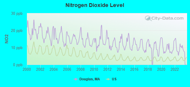
Nitrogen Dioxide (NO2) [ppb] level in 2022 was 10.1. This is significantly worse than average. Closest monitor was 7.0 miles away from the city center.
| City: | 10.1 |
| U.S.: | 5.1 |
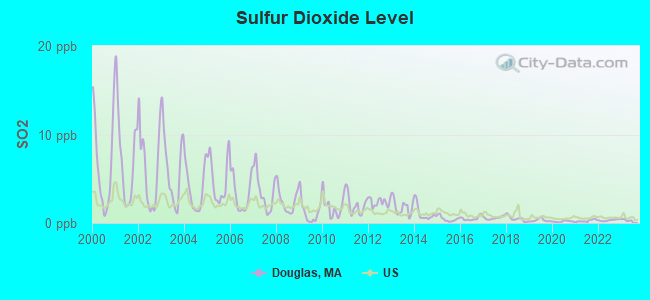
Sulfur Dioxide (SO2) [ppb] level in 2022 was 0.318. This is significantly better than average. Closest monitor was 7.0 miles away from the city center.
| City: | 0.318 |
| U.S.: | 1.515 |
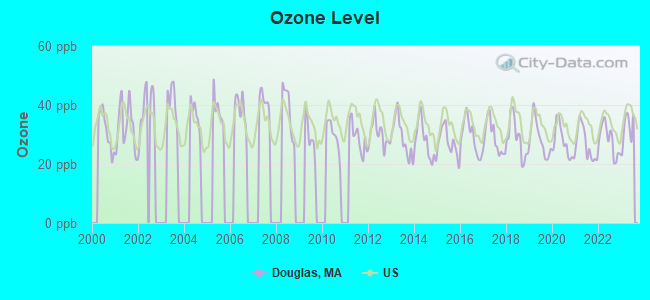
Ozone [ppb] level in 2023 was 31.9. This is about average. Closest monitor was 6.6 miles away from the city center.
| City: | 31.9 |
| U.S.: | 33.3 |
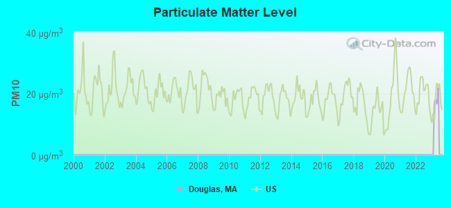
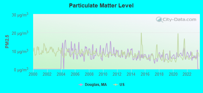
Particulate Matter (PM2.5) [µg/m3] level in 2022 was 7.34. This is about average. Closest monitor was 10.3 miles away from the city center.
| City: | 7.34 |
| U.S.: | 8.11 |
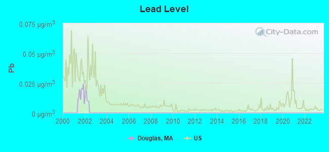
Lead (Pb) [µg/m3] level in 2001 was 0.0159. This is significantly worse than average. Closest monitor was 13.1 miles away from the city center.
| City: | 0.0159 |
| U.S.: | 0.0093 |
Tornado activity:
Douglas-area historical tornado activity is slightly above Massachusetts state average. It is 28% smaller than the overall U.S. average.
On 6/9/1953, a category F4 (max. wind speeds 207-260 mph) tornado 20.2 miles away from the Douglas town center killed 90 people and injured 1228 people and caused between $50,000,000 and $500,000,000 in damages.
On 6/9/1953, a category F3 (max. wind speeds 158-206 mph) tornado 8.2 miles away from the town center injured 17 people and caused between $500,000 and $5,000,000 in damages.
Earthquake activity:
Douglas-area historical earthquake activity is significantly above Massachusetts state average. It is 72% smaller than the overall U.S. average.On 10/7/1983 at 10:18:46, a magnitude 5.3 (5.1 MB, 5.3 LG, 5.1 ML, Class: Moderate, Intensity: VI - VII) earthquake occurred 186.2 miles away from the city center
On 4/20/2002 at 10:50:47, a magnitude 5.3 (5.3 ML, Depth: 3.0 mi) earthquake occurred 196.7 miles away from the city center
On 4/20/2002 at 10:50:47, a magnitude 5.2 (5.2 MB, 4.2 MS, 5.2 MW, 5.0 MW) earthquake occurred 195.7 miles away from the city center
On 1/19/1982 at 00:14:42, a magnitude 4.7 (4.5 MB, 4.7 MD, 4.5 LG, Class: Light, Intensity: IV - V) earthquake occurred 100.2 miles away from the city center
On 10/16/2012 at 23:12:25, a magnitude 4.7 (4.7 ML, Depth: 10.0 mi) earthquake occurred 119.9 miles away from the city center
On 8/22/1992 at 12:20:32, a magnitude 4.8 (4.8 MB, 3.8 MS, 4.7 LG, Depth: 6.2 mi) earthquake occurred 217.0 miles away from Douglas center
Magnitude types: regional Lg-wave magnitude (LG), body-wave magnitude (MB), duration magnitude (MD), local magnitude (ML), surface-wave magnitude (MS), moment magnitude (MW)
Natural disasters:
The number of natural disasters in Worcester County (27) is a lot greater than the US average (15).Major Disasters (Presidential) Declared: 15
Emergencies Declared: 12
Causes of natural disasters: Floods: 9, Storms: 8, Hurricanes: 6, Snowstorms: 5, Winter Storms: 4, Blizzards: 2, Snows: 2, Fire: 1, Heavy Rain: 1, Snowfall: 1, Tornado: 1, Wind: 1 (Note: some incidents may be assigned to more than one category).

Hospitals and medical centers near Douglas:
- EAST WALLUM LAKE GROUP HOME (Hospital, about 5 miles away; PASCOAG, RI)
- CARE PROVIDERS OF BLACKSTONE VALLEY (Home Health Center, about 6 miles away; WHITINSVILLE, MA)
- LYDIA TAFT HOUSE (Nursing Home, about 6 miles away; UXBRIDGE, MA)
- ST CAMILLUS HOSPITAL (Hospital, about 6 miles away; WHITINSVILLE, MA)
- ST CAMILLUS HEALTH CENTER (Nursing Home, about 6 miles away; WHITINSVILLE, MA)
- HUBBARD REGIONAL HOSPITAL (Hospital, about 7 miles away; WEBSTER, MA)
- SOUTH COUNTY DIALYSIS CENTER (Dialysis Facility, about 7 miles away; WEBSTER, MA)
Amtrak station near Douglas:
Colleges/universities with over 2000 students nearest to Douglas:
- College of the Holy Cross (about 14 miles; Worcester, MA; Full-time enrollment: 3,125)
- Bryant University (about 14 miles; Smithfield, RI; FT enrollment: 3,440)
- Clark University (about 15 miles; Worcester, MA; FT enrollment: 3,687)
- Worcester Polytechnic Institute (about 16 miles; Worcester, MA; FT enrollment: 3,930)
- Worcester State University (about 16 miles; Worcester, MA; FT enrollment: 5,426)
- Assumption College (about 18 miles; Worcester, MA; FT enrollment: 2,580)
- Quinsigamond Community College (about 19 miles; Worcester, MA; FT enrollment: 5,877)
Public high school in Douglas:
- DOUGLAS HIGH SCHOOL (Students: 548, Location: 33 DAVIS STREET, Grades: 9-12)
Public elementary/middle schools in Douglas:
- DOUGLAS ELEMENTARY SCHOOL (Students: 377, Location: 19 DAVIS STREET, Grades: 2-5)
- DOUGLAS MIDDLE SCHOOL (Location: 21 DAVIS STREET, Grades: 6-8)
- DOUGLAS PRIMARY SCHOOL (Location: 17 GLEASON COURT, Grades: PK-1)
Points of interest:
Notable locations in Douglas: Hayward Mill (A), Douglas Orchard (B), Douglas Fire Department (C). Display/hide their locations on the map
Churches in Douglas include: First Congregational Church (A), East Douglas United Methodist Church (B). Display/hide their locations on the map
Cemeteries: Evergreen Cemetery (1), South Douglas Cemetery (2), Douglas Center Cemetery (3), Saint Denis Cemetery (4). Display/hide their locations on the map
Lakes, reservoirs, and swamps: Grassy Pond (A), Badluck Lake (B), Chamberlain Pond (C), Wallis Pond (D), Bating Pond (E), Chase Pond (F), Hunt Pond (G), Morse Pond (H). Display/hide their locations on the map
Streams, rivers, and creeks: Bating Brook (A), Caswell Brook (B), Cedar Swamp Brook (C), Centerville Brook (D), Dudley Brook (E), Gilboa Brook (F), Greene Brook (G), Riddle Brook (H), Wellman Brook (I). Display/hide their locations on the map
Tourist attraction: Breezy Picnic Grounds Waterslides (Amusement & Theme Parks; 520 N Street) (1). Display/hide its approximate location on the map
Birthplace of: Karen Thatcher - Ice hockey player, Leonard White (physician) - Physician, Bowman Brown Law - Politician, John R. Thayer - Politician, Mike Brannock - Baseball player.
Drinking water stations with addresses in Douglas and their reported violations in the past:
DOUGLAS WATER DEPARTMENT (Population served: 3,855, Groundwater):Past health violations:
- MCL, Monthly (TCR) - In JUN-2014, Contaminant: Coliform. Follow-up actions: St AO (w/o penalty) issued (SEP-09-2014)
- MCL, Monthly (TCR) - In AUG-2013, Contaminant: Coliform. Follow-up actions: St AO (w/o penalty) issued (OCT-29-2013), St Compliance achieved (OCT-29-2013)
- MCL, Monthly (TCR) - In JUL-2013, Contaminant: Coliform. Follow-up actions: St AO (w/o penalty) issued (OCT-29-2013), St Compliance achieved (OCT-29-2013)
- MCL, Monthly (TCR) - In DEC-2010, Contaminant: Coliform. Follow-up actions: St AO (w/o penalty) issued (FEB-23-2011), St Compliance achieved (FEB-23-2011)
- MCL, Monthly (TCR) - In SEP-2009, Contaminant: Coliform. Follow-up actions: St AO (w/o penalty) issued (NOV-05-2009), St Compliance achieved (NOV-05-2009)
- MCL, Monthly (TCR) - In DEC-2008, Contaminant: Coliform. Follow-up actions: St AO (w/o penalty) issued (JAN-26-2009), St Compliance achieved (JAN-26-2009)
- MCL, Monthly (TCR) - In NOV-2006, Contaminant: Coliform. Follow-up actions: St AO (w/o penalty) issued (JAN-16-2007)
| This town: | 2.8 people |
| Massachusetts: | 2.5 people |
| This town: | 78.4% |
| Whole state: | 63.0% |
| This town: | 6.5% |
| Whole state: | 7.0% |
Likely homosexual households (counted as self-reported same-sex unmarried-partner households)
- Lesbian couples: 0.5% of all households
- Gay men: 0.3% of all households
| This town: | 4.6% |
| Whole state: | 9.3% |
| This town: | 1.9% |
| Whole state: | 4.4% |
For population 15 years and over in Douglas:
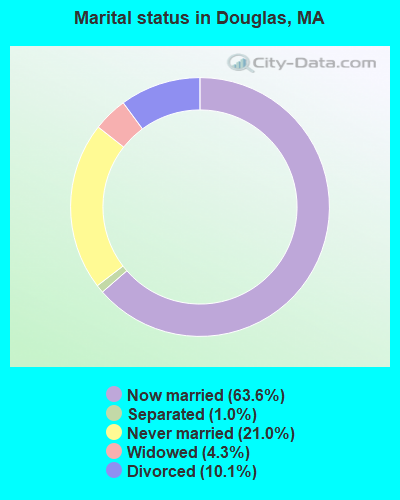
- Never married: 21.0%
- Now married: 63.6%
- Separated: 1.0%
- Widowed: 4.3%
- Divorced: 10.1%
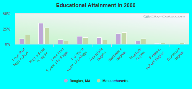
For population 25 years and over in Douglas:
- High school or higher: 90.8%
- Bachelor's degree or higher: 24.0%
- Graduate or professional degree: 6.6%
- Unemployed: 1.9%
- Mean travel time to work (commute): 30.9 minutes
| Here: | 9.5 |
| Massachusetts average: | 13.1 |


Graphs represent county-level data. Detailed 2008 Election Results
Religion statistics for Douglas, MA (based on Worcester County data)


| Religion | Adherents | Congregations |
|---|---|---|
| Catholic | 306,925 | 118 |
| Mainline Protestant | 43,326 | 171 |
| Evangelical Protestant | 37,511 | 203 |
| Other | 18,931 | 69 |
| Orthodox | 7,935 | 15 |
| Black Protestant | 497 | 6 |
| None | 383,427 | - |
Food Environment Statistics:
| Here: | 1.73 / 10,000 pop. |
| Massachusetts: | 1.98 / 10,000 pop. |
| This county: | 0.05 / 10,000 pop. |
| Massachusetts: | 0.05 / 10,000 pop. |
| Worcester County: | 1.79 / 10,000 pop. |
| Massachusetts: | 2.22 / 10,000 pop. |
| Worcester County: | 2.22 / 10,000 pop. |
| Massachusetts: | 1.77 / 10,000 pop. |
| Worcester County: | 7.27 / 10,000 pop. |
| State: | 8.76 / 10,000 pop. |
| This county: | 8.0% |
| Massachusetts: | 8.1% |
| Worcester County: | 24.0% |
| Massachusetts: | 22.5% |
| Worcester County: | 16.6% |
| Massachusetts: | 16.5% |
4.71% of this county's 2021 resident taxpayers lived in other counties in 2020 ($76,229 average adjusted gross income)
| Here: | 4.71% |
| Massachusetts average: | 6.35% |
0.02% of residents moved from foreign countries ($100 average AGI)
Worcester County: 0.02% Massachusetts average: 0.01%
Top counties from which taxpayers relocated into this county between 2020 and 2021:
| from Middlesex County, MA | |
| from Norfolk County, MA | |
| from Suffolk County, MA |
4.84% of this county's 2020 resident taxpayers moved to other counties in 2021 ($87,252 average adjusted gross income)
| Here: | 4.84% |
| Massachusetts average: | 7.18% |
0.03% of residents moved to foreign countries ($199 average AGI)
Worcester County: 0.03% Massachusetts average: 0.02%
Top counties to which taxpayers relocated from this county between 2020 and 2021:
| to Middlesex County, MA | |
| to Norfolk County, MA | |
| to Suffolk County, MA |
Businesses in Douglas, MA
- Dunkin Donuts: 1
Strongest AM radio stations in Douglas:
- WALE (990 AM; 50 kW; GREENVILLE, RI; Owner: NORTH AMERICAN BROADCASTING CO., INC.)
- WCRN (830 AM; 50 kW; WORCESTER, MA; Owner: CARTER BROADCASTING CORPORATION)
- WKOX (1200 AM; 50 kW; FRAMINGHAM, MA; Owner: CAPSTAR TX LIMITED PARTNERSHIP)
- WBIX (1060 AM; 40 kW; NATICK, MA; Owner: LANGER BROADCASTING CORPORATION)
- WEEI (850 AM; 50 kW; BOSTON, MA; Owner: ENTERCOM BOSTON LICENSE, LLC)
- WAMG (890 AM; 25 kW; DEDHAM, MA; Owner: MEGA COMMUNICATIONS OF DEDHAM LICENSEE, LLC)
- WVNE (760 AM; daytime; 25 kW; LEICESTER, MA; Owner: BLOUNT MASSCOM, INC.)
- WRKO (680 AM; 50 kW; BOSTON, MA; Owner: ENTERCOM BOSTON LICENSE, LLC)
- WGFP (940 AM; 1 kW; WEBSTER, MA; Owner: CHOWDER BROADCAST GROUP LLC)
- WWZN (1510 AM; 50 kW; BOSTON, MA; Owner: ROSE CITY RADIO CORPORATION)
- WNNZ (640 AM; 50 kW; WESTFIELD, MA; Owner: CLEAR CHANNEL BROADCASTING LICENSES, INC.)
- WORC (1310 AM; 5 kW; WORCESTER, MA; Owner: CHOWDER BROADCAST GROUP LLC)
- WBZ (1030 AM; 50 kW; BOSTON, MA; Owner: INFINITY BROADCASTING OPERATIONS, INC.)
Strongest FM radio stations in Douglas:
- WAAF (107.3 FM; WORCESTER, MA; Owner: ENTERCOM BOSTON LICENSE, LLC)
- WWKX (106.3 FM; WOONSOCKET, RI; Owner: AAA ENTERTAINMENT LICENSING LLC)
- WSRS (96.1 FM; WORCESTER, MA; Owner: CAPSTAR TX LIMITED PARTNERSHIP)
- WWFX (100.1 FM; SOUTHBRIDGE, MA; Owner: CITADEL BROADCASTING COMPANY)
- WYCM (90.1 FM; CHARLTON, MA; Owner: BAY PATH VOCATIONAL HIGH SCHOOL)
- WORC-FM (98.9 FM; WEBSTER, MA; Owner: CITADEL BROADCASTING COMPANY)
- WWBB (101.5 FM; PROVIDENCE, RI; Owner: CLEAR CHANNEL BROADCASTING LICENSES, INC.)
- WBMX (98.5 FM; BOSTON, MA; Owner: INFINITY RADIO OPERATIONS INC.)
- WJMN (94.5 FM; BOSTON, MA; Owner: AMFM RADIO LICENSES, L.L.C.)
- WCRB (102.5 FM; WALTHAM, MA; Owner: CHARLES RIVER BROADCASTING WCRB LICE)
- WTKK (96.9 FM; BOSTON, MA; Owner: GREATER BOSTON RADIO, INC.)
- WBOS (92.9 FM; BROOKLINE, MA; Owner: GREATER BOSTON RADIO, INC.)
- WROR-FM (105.7 FM; FRAMINGHAM, MA; Owner: GREATER BOSTON RADIO, INC.)
- WGBH (89.7 FM; BOSTON, MA; Owner: WGBH EDUCATIONAL FOUNDATION)
- WICN (90.5 FM; WORCESTER, MA; Owner: WICN PUBLIC RADIO, INC)
- WBUR-FM (90.9 FM; BOSTON, MA; Owner: TRUSTEES OF BOSTON UNIVERSITY)
- WXKS-FM (107.9 FM; MEDFORD, MA; Owner: AMFM RADIO LICENSES, L.L.C.)
- WPRO-FM (92.3 FM; PROVIDENCE, RI; Owner: CITADEL BROADCASTING COMPANY)
- WODS (103.3 FM; BOSTON, MA; Owner: INFINITY BROADCASTING OPERATIONS, INC.)
- WMJX (106.7 FM; BOSTON, MA; Owner: GREATER BOSTON RADIO, INC.)
TV broadcast stations around Douglas:
- WUNI (Channel 27; WORCESTER, MA; Owner: ENTRAVISION HOLDINGS, LLC)
- WCVB-TV (Channel 5; BOSTON, MA; Owner: WCVB HEARST-ARGYLE TV, INC.)
- WGBH-TV (Channel 2; BOSTON, MA; Owner: WGBH EDUCATIONAL FOUNDATION)
- WUTF (Channel 66; MARLBOROUGH, MA; Owner: TELEFUTURA BOSTON LLC)
- WPXQ (Channel 69; BLOCK ISLAND, RI; Owner: OCEAN STATE TELEVISION, L.L.C.)
- WYDN (Channel 48; WORCESTER, MA; Owner: EDUCATIONAL PUBLIC TV CORPORATION)
- WMFP (Channel 62; LAWRENCE, MA; Owner: WSAH LICENSE, INC.)
- WHDH-TV (Channel 7; BOSTON, MA; Owner: WHDH-TV)
- WBZ-TV (Channel 4; BOSTON, MA; Owner: VIACOM INC.)
- WGBX-TV (Channel 44; BOSTON, MA; Owner: WGBH EDUCATIONAL FOUNDATION)
- WSBK-TV (Channel 38; BOSTON, MA; Owner: VIACOM INC.)
- WLVI-TV (Channel 56; CAMBRIDGE, MA; Owner: WLVI, INC.)
- WNAC-TV (Channel 64; PROVIDENCE, RI; Owner: WNAC, LLC)
- WPRI-TV (Channel 12; PROVIDENCE, RI; Owner: TVL BROADCASTING OF RHODE ISLAND, LLC)
- WFXT (Channel 25; BOSTON, MA; Owner: FOX TELEVISION STATIONS INC.)
- WJAR (Channel 10; PROVIDENCE, RI; Owner: OUTLET BROADCASTING, INC.)
- WLNE-TV (Channel 6; NEW BEDFORD, MA; Owner: FREEDOM BROADCASTING OF SOUTHERN NEW ENGLAND, INC.)
- WSBE-TV (Channel 36; PROVIDENCE, RI; Owner: RHODE ISLAND PUBLIC TELECOM. AUTHORITY)
- WWDP (Channel 46; NORWELL, MA; Owner: NORWELL TELEVISION, LLC)
- W40BO (Channel 40; BOSTON, MA; Owner: PAXSON COMMUNICATIONS LPTV, INC.)
- WRIW-LP (Channel 50; PROVIDENCE, RI; Owner: ZGS PROVIDENCE, INC.)
- WCRN-LP (Channel 34; LEICESTER, MA; Owner: CARTER BROADCASTING CORPORATION)
- WBPX (Channel 68; BOSTON, MA; Owner: PAXSON BOSTON-68 LICENSE, INC.)
- WTMU-LP (Channel 32; BOSTON, MA; Owner: ZGS BOSTON, INC.)
- WCEA-LP (Channel 58; BOSTON, MA; Owner: CHANNEL 19 TV CORPORATION)
- National Bridge Inventory (NBI) Statistics
- 8Number of bridges
- 30ft / 9.4mTotal length
- $8,085,000Total costs
- 18,609Total average daily traffic
- 1,141Total average daily truck traffic
- 29,406Total future (year 2031) average daily traffic
FCC Registered Antenna Towers:
4- EDWARD G ROACH, 93 Southwest Main Street (Lat: 42.049611 Lon: -71.759000), Type: 60.6, Overall height: 57.9 m, Registrant: None
- Edward G Roach, 93 Southwest Main Street (Lat: 42.049611 Lon: -71.759000), Type: 60.6, Overall height: 57.9 m, Registrant: None
- Edward G Roach, 93 Southwest Main Street (Lat: 42.049611 Lon: -71.759000), Type: 60.6, Overall height: 57.9 m, Registrant: None
- Edward G Roach, 93 Southwest Main Street (Lat: 42.049611 Lon: -71.759000), Type: 60.6, Structure height: 25027 m, Overall height: 57.9 m, Registrant: Sba Towers, LLC, Eroach@sbasite.Com, , Boca -Raton, Phone: (561) 995-7670
FCC Registered Broadcast Land Mobile Towers:
4- 17 Church Street (Lat: 42.060806 Lon: -71.744111), Type: Tower, Structure height: 58 m, Call Sign: KXG854, Licensee ID: L00040633,
Assigned Frequencies: 460.487 MHz, 37.9200 MHz, Grant Date: 03/31/2015, Expiration Date: 05/15/2025, Registrant: Douglas, Town Of
- Douglas State Forest Headquarters (Lat: 42.034000 Lon: -71.772028), Type: Tower, Structure height: 12 m, Overall height: 18 m, Call Sign: WPLG562,
Assigned Frequencies: 151.205 MHz, 151.235 MHz, 151.310 MHz, 151.370 MHz, 151.415 MHz, Grant Date: 01/05/2022, Expiration Date: 04/01/2032, Certifier: Richard Geyster, Registrant: Massachusett, Comm Of, 180 Beaman St., West Boylston, MA 01583, Phone: (617) 828-1617, Fax: (508) 792-7805, Email:
- Lat: 42.074028 Lon: -71.709444, Call Sign: WPZR570,
Assigned Frequencies: 461.712 MHz, 456.450 MHz, 451.450 MHz, Grant Date: 11/30/2023, Expiration Date: 02/26/2034, Certifier: Robert P Kozlowski, Registrant: Douglas Public Schools, 21 Davis Street, Douglas, MA 01516, Phone: (508) 476-4037, Fax: (508) 476-4423, Email:
- 33 Davis St (Lat: 42.067472 Lon: -71.700000), Type: Bant, Structure height: 15.2 m, Call Sign: WRNV684,
Assigned Frequencies: 154.497 MHz, Grant Date: 08/30/2021, Expiration Date: 08/30/2031, Certifier: Bruce Marcus, Registrant: Marcus Spectrum Holdings, LLC, 33 Mitchell Dr, Manchester, CT 06045, Phone: (860) 646-1839, Fax: (860) 649-8492, Email:
FCC Registered Microwave Towers:
4- DOUGLAS, 17 Church St (Lat: 42.060806 Lon: -71.744111), Type: Tower, Structure height: 60.7 m, Call Sign: WQKP503,
Assigned Frequencies: 10652.5 MHz, Grant Date: 08/03/2009, Expiration Date: 08/03/2019, Cancellation Date: 02/25/2014, Certifier: Pamelia Y Hoof, Registrant: Verizon Wireless, 1120 Sanctuary Pkwy, #150 Gasa5reg, Alpharetta, GA 30009-7630, Phone: (770) 797-1070, Fax: (770) 797-1036, Email:
- BS54XC086, 93 Southwest Main Street (Lat: 42.049611 Lon: -71.759000), Type: Mtower, Structure height: 57.9 m, Overall height: 60.6 m, Call Sign: WQWG666,
Assigned Frequencies: 19425.0 MHz, 19425.0 MHz, 19425.0 MHz, 19425.0 MHz, 19425.0 MHz, 19425.0 MHz, 19425.0 MHz, Grant Date: 08/17/2015, Expiration Date: 08/17/2025, Cancellation Date: 05/12/2023, Certifier: David Werblow, Registrant: T-Mobile Usa, Inc., 12920 Se 38th Street, Bellevue, WA 98006, Phone: (425) 383-8401, Email:
- DOUGLAS FIRE, 64 Main St (Lat: 42.060806 Lon: -71.733556), Type: Building, Structure height: 22.9 m, Call Sign: WRTT392, Licensee ID: L00040633,
Assigned Frequencies: 22030.0 MHz, 22030.0 MHz, 22030.0 MHz, 22030.0 MHz, 22030.0 MHz, 22030.0 MHz, 22030.0 MHz, 22030.0 MHz, 22030.0 MHz, 22030.0 MHz, Grant Date: 07/21/2022, Expiration Date: 07/21/2032, Certifier: Matthew Wojcik, Registrant: Douglas, Town Of, 29 Depot St, Douglas, MA 01516, Phone: (508) 476-4000, Email:
- DOUGLAS MONOPOLE, 33 Church St (Lat: 42.060778 Lon: -71.744167), Type: Mtower, Structure height: 55.8 m, Call Sign: WRTT394, Licensee ID: L00040633,
Assigned Frequencies: 23230.0 MHz, 23280.0 MHz, 23230.0 MHz, 23280.0 MHz, 23230.0 MHz, 23280.0 MHz, 23230.0 MHz, 23280.0 MHz, 23230.0 MHz, 23280.0 MHz... (+10 more), Grant Date: 07/21/2022, Expiration Date: 07/21/2032, Certifier: Matthew Wojcik, Registrant: Douglas, Town Of, 29 Depot St, Douglas, MA 01516, Phone: (508) 476-4000, Email:
FCC Registered Amateur Radio Licenses:
50 (See the full list of FCC Registered Amateur Radio Licenses in Douglas)FAA Registered Aircraft Manufacturers and Dealers:
1 (See the full list of FAA Registered Manufacturers and Dealers in Douglas)FAA Registered Aircraft:
8 (See the full list of FAA Registered Aircraft)2002 - 2018 National Fire Incident Reporting System (NFIRS) incidents
- Fire incident types reported to NFIRS in Douglas, MA
- 33951.4%Structure Fires
- 24537.1%Outside Fires
- 477.1%Mobile Property/Vehicle Fires
- 294.4%Other
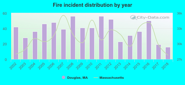 Based on the data from the years 2002 - 2018 the average number of fires per year is 39. The highest number of fire incidents - 56 took place in 2008, and the least - 16 in 2018. The data has a dropping trend.
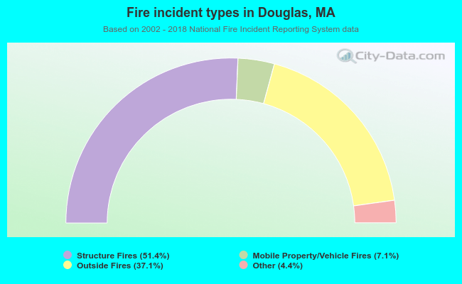 When looking into fire subcategories, the most incidents belonged to: Structure Fires (51.4%), and Outside Fires (37.1%).
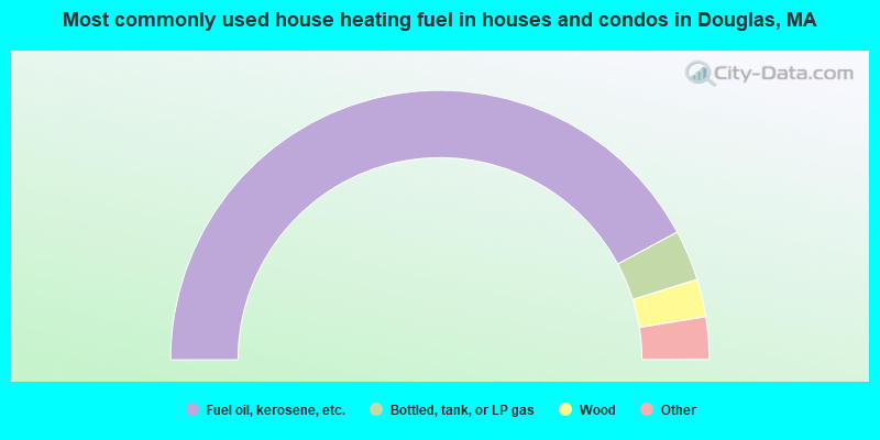
- 84.3%Fuel oil, kerosene, etc.
- 6.1%Bottled, tank, or LP gas
- 4.5%Wood
- 3.5%Electricity
- 1.6%Utility gas
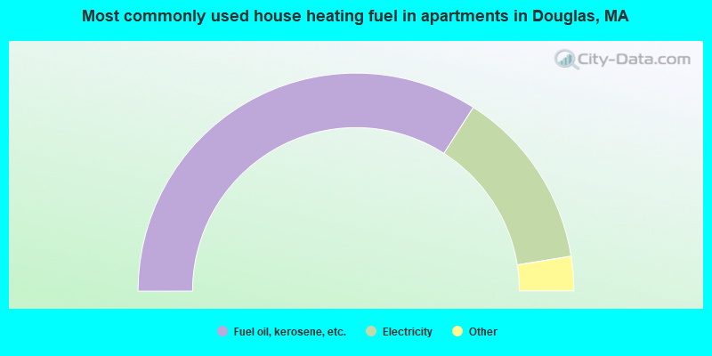
- 68.1%Fuel oil, kerosene, etc.
- 26.8%Electricity
- 3.1%Utility gas
- 2.0%Bottled, tank, or LP gas
Douglas compared to Massachusetts state average:
- Unemployed percentage significantly below state average.
- Black race population percentage significantly below state average.
- Hispanic race population percentage significantly below state average.
- Foreign-born population percentage significantly below state average.
- Renting percentage significantly below state average.
- Length of stay since moving in significantly above state average.
- Number of rooms per house significantly below state average.
- House age significantly below state average.
Douglas on our top lists:
- #10 on the list of "Top 101 cities with largest percentage of females in occupations: other financial specialists (population 5,000+)"
- #11 on the list of "Top 101 cities with largest percentage of females in occupations: bookkeeping, accounting, and auditing clerks (population 5,000+)"
- #18 on the list of "Top 101 cities with largest percentage of females in industries: metal and metal products (population 5,000+)"
- #30 on the list of "Top 101 cities with largest percentage of males in occupations: other transportation workers (population 5,000+)"
- #34 on the list of "Top 101 cities with largest percentage of females in industries: office supplies and stationery stores (population 5,000+)"
- #35 on the list of "Top 101 cities with largest percentage of females in industries: fuel dealers (population 5,000+)"
- #37 on the list of "Top 101 cities with largest percentage of males in occupations: secondary school teachers (population 5,000+)"
- #37 on the list of "Top 101 cities with largest percentage of females in industries: lumber and other construction materials merchant wholesalers (population 5,000+)"
- #42 on the list of "Top 101 cities with largest percentage of males in occupations: extraction workers (population 5,000+)"
- #43 on the list of "Top 101 cities with the lowest number of thefts per 100,000 residents (population 5,000+)"
- #45 on the list of "Top 101 cities with largest percentage of females in occupations: metal workers and plastic workers (population 5,000+)"
- #54 on the list of "Top 101 cities with largest percentage of females in industries: machinery (population 5,000+)"
- #62 on the list of "Top 101 cities with largest percentage of females in industries: building material and garden equipment and supplies dealers (population 5,000+)"
- #63 on the list of "Top 101 cities with largest percentage of females in industries: truck transportation (population 5,000+)"
- #67 on the list of "Top 101 cities with largest percentage of males in industries: nonmetallic mineral products (population 5,000+)"
- #71 on the list of "Top 101 cities with largest percentage of males in industries: computer and electronic products (population 5,000+)"
- #72 on the list of "Top 101 cities with largest percentage of females in industries: miscellaneous durable goods merchant wholesalers (population 5,000+)"
- #73 on the list of "Top 101 cities with largest percentage of males in industries: metals and minerals, except petroleum, merchant wholesalers (population 5,000+)"
- #91 on the list of "Top 101 cities with largest percentage of males in industries: clothing and accessories, including shoe, stores (population 5,000+)"
- #100 on the list of "Top 101 cities with largest percentage of males in industries: warehousing and storage (population 5,000+)"
- #4 on the list of "Top 101 counties with the highest carbon monoxide air pollution readings in 2012 (ppm)"
- #5 on the list of "Top 101 counties with the most Catholic congregations"
- #12 on the list of "Top 101 counties with the highest surface withdrawal of fresh water for public supply"
- #16 on the list of "Top 101 counties with the highest total withdrawal of fresh water for public supply"
- #23 on the list of "Top 101 counties with the highest Sulfur Oxides Annual air pollution readings in 2012 (µg/m3)"

|
|
Total of 99 patent applications in 2008-2024.