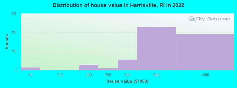
Estimated median house or condo value in 2022: $394,279 (it was $123,500 in 2000)
Harrisville:
$394,279
RI:
$383,900
Mean prices in 2022:all housing units: $374,091; detached houses: $391,079; townhouses or other attached units: $339,877; in 2-unit structures: $329,737; in 3-to-4-unit structures: $340,395; in 5-or-more-unit structures: $281,172; mobile homes: $172,414
Median gross rent in 2022: $796.
March 2022 cost of living index in Harrisville: 90.9 (less than average, U.S. average is 100)
According to our research of Rhode Island and other state lists, there were 2 registered sex offenders living in Harrisville, Rhode Island as of May 11, 2024. The ratio of all residents to sex offenders in Harrisville is 818 to 1. The ratio of registered sex offenders to all residents in this city is near the state average.
Recent articles from our blog. Our writers, many of them Ph.D. graduates or candidates, create easy-to-read articles on a wide variety of topics.
Latest news from Harrisville, RI collected exclusively by city-data.com from local newspapers, TV, and radio stations
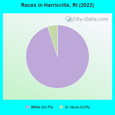
Ancestries: French (31.2%), French Canadian (20.8%), Greek (12.4%), Irish (12.4%), Polish (10.4%), English (9.0%).
Current Local Time: EST time zone
Elevation: 336 feet
Land area: 0.81 square miles.
Population density: 1,978 people per square mile (low).
82 residents are foreign born (5.3% Europe).
This place:
5.4%
Rhode Island:
14.4%
Median real estate property taxes paid for housing units with mortgages in 2022: $4,172 (1.0%) Median real estate property taxes paid for housing units with no mortgage in 2022: $3,157 (0.9%)
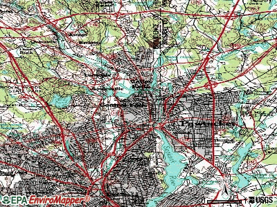
Nearest city with pop. 50,000+: Providence, RI (16.6 miles , pop. 173,618).
Nearest city with pop. 200,000+: Boston, MA (38.9 miles , pop. 589,141).
Nearest city with pop. 1,000,000+: Bronx, NY (137.7 miles , pop. 1,332,650).
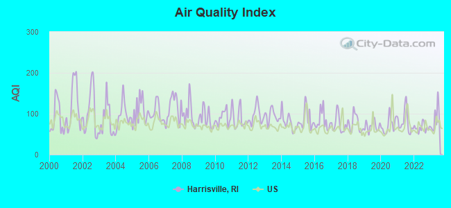
Air Quality Index (AQI) level in 2023 was 87.3. This is worse than average.
City:
87.3
U.S.:
72.6
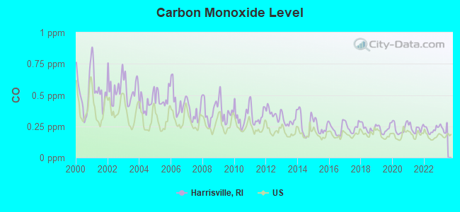
Carbon Monoxide (CO) [ppm] level in 2022 was 0.224. This is about average.Closest monitor was 16.4 miles away from the city center.
City:
0.224
U.S.:
0.251
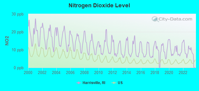
Nitrogen Dioxide (NO2) [ppb] level in 2022 was 10.1. This is significantly worse than average.Closest monitor was 0.9 miles away from the city center.
City:
10.1
U.S.:
5.1
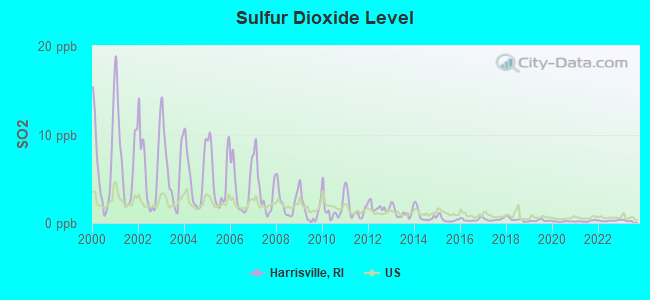
Sulfur Dioxide (SO2) [ppb] level in 2022 was 0.263. This is significantly better than average.Closest monitor was 0.9 miles away from the city center.
City:
0.263
U.S.:
1.515
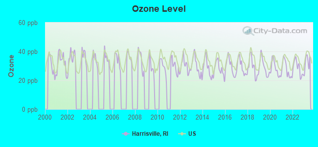
Ozone [ppb] level in 2023 was 32.3. This is about average.Closest monitor was 9.6 miles away from the city center.
City:
32.3
U.S.:
33.3
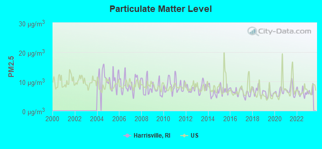
Particulate Matter (PM2.5) [µg/m3] level in 2022 was 6.23. This is better than average.Closest monitor was 3.9 miles away from the city center.
City:
6.23
U.S.:
8.11
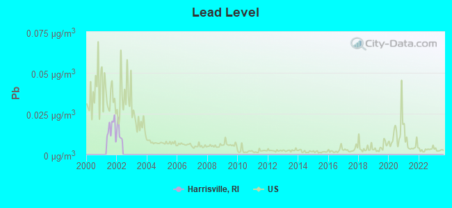
Lead (Pb) [µg/m3] level in 2001 was 0.0160. This is significantly worse than average.Closest monitor was 12.4 miles away from the city center.
City:
0.0160
U.S.:
0.0093
Tornado activity:
Harrisville-area historical tornado activity is slightly above Rhode Island state average. It is 33% smaller than the overall U.S. average.
On 6/9/1953, a category F4 (max. wind speeds 207-260 mph) tornado 24.4 miles away from the Harrisville place center killed 90 peopleand injured 1228 peopleand causedbetween $50,000,000 and $500,000,000 in damages.
On 6/9/1953, a category F3 (max. wind speeds 158-206 mph) tornado 14.7 miles away from the place center injured 17 peopleand causedbetween $500,000 and $5,000,000 in damages.
Earthquake activity:
Harrisville-area historical earthquake activity is significantly above Rhode Island state average. It is 72% smaller than the overall U.S. average.
On 10/7/1983 at 10:18:46, a magnitude 5.3 (5.1 MB, 5.3 LG, 5.1 ML, Class: Moderate, Intensity: VI - VII) earthquake occurred 192.3 miles away from the city center On 4/20/2002 at 10:50:47, a magnitude 5.3 (5.3 ML, Depth: 3.0 mi) earthquake occurred 203.2 miles away from Harrisville center On 4/20/2002 at 10:50:47, a magnitude 5.2 (5.2 MB, 4.2 MS, 5.2 MW, 5.0 MW) earthquake occurred 202.2 miles away from the city center On 1/19/1982 at 00:14:42, a magnitude 4.7 (4.5 MB, 4.7 MD, 4.5 LG, Class: Light, Intensity: IV - V) earthquake occurred 106.0 miles away from the city center On 10/16/2012 at 23:12:25, a magnitude 4.7 (4.7 ML, Depth: 10.0 mi) earthquake occurred 124.1 miles away from Harrisville center On 8/22/1992 at 12:20:32, a magnitude 4.8 (4.8 MB, 3.8 MS, 4.7 LG, Depth: 6.2 mi) earthquake occurred 210.5 miles away from the city center Magnitude types: regional Lg-wave magnitude (LG), body-wave magnitude (MB), duration magnitude (MD), local magnitude (ML), surface-wave magnitude (MS), moment magnitude (MW)
Natural disasters:
The number of natural disasters in Providence County (17) is near the US average (15). Major Disasters (Presidential) Declared: 7 Emergencies Declared: 10
Causes of natural disasters: Hurricanes: 5, Snowstorms: 4, Blizzards: 3, Floods: 2, Storms: 2, Winter Storms: 2, Snow: 1, Snowfall: 1, Tropical Storm: 1, Water Main Break: 1, Wind: 1, Other: 1 (Note: some incidents may be assigned to more than one category).
Hospitals and medical centers in Harrisville:
DR U E ZAMBARANO HOSPITAL (WALLUM LAKE)
Other hospitals and medical centers near Harrisville:
NICOLE MANOR (Nursing Home, about 2 miles away; PASCOAG, RI)
OVERLOOK NURSING AND REHABILITATION CENTER (Nursing Home, about 2 miles away; PASCOAG, RI)
BAYBERRY COMMONS (Nursing Home, about 3 miles away; PASCOAG, RI)
PINE GROVE HEALTH CENTER (Nursing Home, about 3 miles away; PASCOAG, RI)
EAST WALLUM LAKE GROUP HOME (Hospital, about 4 miles away; PASCOAG, RI)
LYDIA TAFT HOUSE (Nursing Home, about 8 miles away; UXBRIDGE, MA)
BLACKSTONE NURSING HOME (Nursing Home, about 8 miles away; BLACKSTONE, MA)
Amtrak station near Harrisville:
17 miles: PROVIDENCE (100 GASPEE ST.) . Services: ticket office, fully wheelchair accessible, enclosed waiting area, public restrooms, public payphones, snack bar, ATM, paid short-term parking, paid long-term parking, call for car rental service, taxi stand, public transit connection.
Colleges/universities with over 2000 students nearest to Harrisville:
Bryant University (about 8 miles; Smithfield, RI; Full-time enrollment: 3,440)
Rhode Island College (about 15 miles; Providence, RI; FT enrollment: 7,189)
Providence College (about 16 miles; Providence, RI; FT enrollment: 4,312)
Johnson & Wales University-Providence (about 18 miles; Providence, RI; FT enrollment: 10,898)
Rhode Island School of Design (about 18 miles; Providence, RI; FT enrollment: 2,714)
Brown University (about 18 miles; Providence, RI; FT enrollment: 8,458)
College of the Holy Cross (about 20 miles; Worcester, MA; FT enrollment: 3,125)
Notable locations in Harrisville: Burrillville Town Hall (A), Jesse M Smith Memorial Library (B), Harrisville Fire Department (C). Display/hide their locations on the map
MCL, Monthly (TCR) - In JAN-2010, Contaminant: Coliform. Follow-up actions: St Violation/Reminder Notice (JAN-12-2010), St Boil Water Order (JAN-12-2010), St Formal NOV issued (JAN-12-2010), St Public Notif requested (JAN-12-2010), St Compliance achieved (JAN-14-2010), St Public Notif received (JAN-14-2010)
Past monitoring violations:
Monitoring, Source Water (GWR) - In JAN-01-2010, Contaminant: E. COLI. Follow-up actions: St Public Notif requested (JAN-13-2010), St Formal NOV issued (JAN-13-2010), St Violation/Reminder Notice (JAN-13-2010), St Public Notif received (JAN-14-2010), St Compliance achieved (FEB-05-2010)
Initial Tap Sampling for Pb and Cu - In JAN-01-2006, Contaminant: Lead and Copper Rule. Follow-up actions: St Public Notif requested (JUN-21-2006), St Formal NOV issued (JUN-21-2006), St Violation/Reminder Notice (JUN-21-2006), St Compliance achieved (JUL-11-2006), St Public Notif received (JUL-11-2006)
SPRING LAKE RECREATIONAL FACILITY (Population served: 450, Groundwater):
Past monitoring violations:
One routine major monitoring violation
COUNTRY VIEW GOLF CLUB (Population served: 185, Groundwater):
Past health violations:
MCL, Monthly (TCR) - In JUN-2010, Contaminant: Coliform. Follow-up actions: St Boil Water Order (JUN-25-2010), St Public Notif requested (JUN-25-2010), St Formal NOV issued (JUN-25-2010), St Violation/Reminder Notice (JUN-25-2010), St Public Notif received (JUL-01-2010), St Compliance achieved (JUL-06-2010)
MCL, Monthly (TCR) - Between APR-2010 and JUN-2010, Contaminant: Coliform. Follow-up actions: St Violation/Reminder Notice (MAY-10-2010), St Boil Water Order (MAY-10-2010), St Formal NOV issued (MAY-10-2010), St Public Notif requested (MAY-10-2010), St Compliance achieved (MAY-18-2010), St Public Notif received (MAY-18-2010)
ST. THERESA OF THE CHILD JESUS CHURCH (Population served: 150, Groundwater):
Past health violations:
MCL, Monthly (TCR) - In FEB-2010, Contaminant: Coliform. Follow-up actions: St Formal NOV issued (MAR-02-2010), St Violation/Reminder Notice (MAR-02-2010), St Public Notif requested (MAR-02-2010), St Public Notif received (MAR-22-2010), St Compliance achieved (MAR-22-2010)
MCL, Monthly (TCR) - In JAN-2010, Contaminant: Coliform. Follow-up actions: St Formal NOV issued (FEB-02-2010), St Violation/Reminder Notice (FEB-02-2010), St Public Notif requested (FEB-02-2010), St Public Notif received (FEB-05-2010), St Compliance achieved (MAR-15-2010)
MCL, Monthly (TCR) - In NOV-2009, Contaminant: Coliform. Follow-up actions: St Formal NOV issued (NOV-04-2009), St Violation/Reminder Notice (NOV-04-2009), St Public Notif requested (NOV-04-2009), St BCA signed (NOV-10-2009), St Public Notif received (NOV-12-2009), St Compliance achieved (DEC-24-2009)
MCL, Monthly (TCR) - In OCT-2009, Contaminant: Coliform. Follow-up actions: St Formal NOV issued (OCT-09-2009), St Violation/Reminder Notice (OCT-09-2009), St Public Notif requested (OCT-09-2009), St Public Notif received (NOV-12-2009), St Compliance achieved (DEC-24-2009)
MCL, Monthly (TCR) - Between JUL-2009 and SEP-2009, Contaminant: Coliform. Follow-up actions: St Formal NOV issued (SEP-11-2009), St Violation/Reminder Notice (SEP-11-2009), St Public Notif requested (SEP-11-2009), St Public Notif received (NOV-12-2009), St Compliance achieved (DEC-24-2009)
MCL, Monthly (TCR) - Between OCT-2007 and DEC-2007, Contaminant: Coliform. Follow-up actions: St Public Notif requested (DEC-03-2007), St Formal NOV issued (DEC-03-2007), St Violation/Reminder Notice (DEC-03-2007), St Public Notif received (DEC-05-2007), St Compliance achieved (DEC-12-2007)
3 other older health violations
Past monitoring violations:
One routine major monitoring violation
WESTERN HOTEL PIZZA & TAVERN DBA AJAR, I (Population served: 110, Groundwater):
Past monitoring violations:
One routine major monitoring violation
NEW ENGLAND FARMS (Population served: 50, Groundwater):
Past health violations:
MCL, Monthly (TCR) - In FEB-2012, Contaminant: Coliform. Follow-up actions: St Violation/Reminder Notice (FEB-16-2012), St Boil Water Order (FEB-16-2012), St Formal NOV issued (FEB-16-2012), St Public Notif requested (FEB-16-2012), St Public Notif received (FEB-22-2012), St Compliance achieved (APR-18-2012)
MCL, Monthly (TCR) - Between JAN-2012 and MAR-2012, Contaminant: Coliform. Follow-up actions: St Violation/Reminder Notice (JAN-12-2012), St Boil Water Order (JAN-12-2012), St Formal NOV issued (JAN-12-2012), St Public Notif requested (JAN-12-2012), St Public Notif received (JAN-24-2012), St Compliance achieved (FEB-01-2012)
Past monitoring violations:
4 routine major monitoring violations
21 regular monitoring violations
OCEAN STATE POWER (Population served: 30, Groundwater):
Past health violations:
MCL, Monthly (TCR) - Between JUL-2007 and SEP-2007, Contaminant: Coliform. Follow-up actions: St Public Notif requested (SEP-19-2007), St Formal NOV issued (SEP-19-2007), St Violation/Reminder Notice (SEP-19-2007), St Public Notif received (SEP-26-2007), St Compliance achieved (OCT-01-2007)
Average household size:
This place:
2.3 people
Rhode Island:
2.4 people
Percentage of family households:
This place:
60.0%
Whole state:
62.8%
Percentage of households with unmarried partners:
This place:
6.7%
Whole state:
7.6%
Likely homosexual households (counted as self-reported same-sex unmarried-partner households)
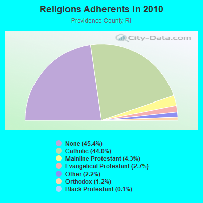
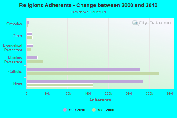
Religion statistics for Harrisville, RI (based on Providence County data)
Religion
Adherents
Congregations
Catholic
276,011
98
Mainline Protestant
27,143
111
Evangelical Protestant
16,895
134
Other
13,896
48
Orthodox
7,325
10
Black Protestant
712
9
None
284,685
-
Source: Clifford Grammich, Kirk Hadaway, Richard Houseal, Dale E.Jones, Alexei Krindatch, Richie Stanley and Richard H.Taylor. 2012. 2010 U.S.Religion Census: Religious Congregations & Membership Study. Association of Statisticians of American Religious Bodies. Jones, Dale E., et al. 2002. Congregations and Membership in the United States 2000. Nashville, TN: Glenmary Research Center. Graphs represent county-level data
Aircraft: ERIC E LAMONTAGNE ELS54K (Category: Land, Weight: Up to 12,499 Pounds), Engine: AMA/EXPR UNKNOWN ENG (None) N-Number: 105EL, N105EL, N-105EL, Serial Number: ELS54K-001, Year manufactured: 2018, Airworthiness Date: 03/31/2018, Certificate Issue Date: 03/31/2020 Registrant (Individual): Eric E Lamontagne, 1590 Tarkiln Rd, Harrisville, RI 02830
Aircraft: ERIC EDWARD LAMONTAGNE ELS 69K (Category: Land, Weight: Up to 12,499 Pounds), Engine: None N-Number: 106EL, N106EL, N-106EL, Serial Number: 001-2016, Year manufactured: 2016, Airworthiness Date: 06/10/2016, Certificate Issue Date: 06/01/2016 Registrant (Individual): Eric E Lamontagne, 1590 Tarklin Rd, Harrisville, RI 02830
Aircraft: CONSOLIDATED AERONAUTICS INC. LAKE LA-4 (Category: Land, Seats: 4, Weight: Up to 12,499 Pounds, Speed: 112 mph), Engine: LYCOMING I0360 SER (180 HP) (Reciprocating) N-Number: 1216L, N1216L, N-1216L, Serial Number: 719, Year manufactured: 1975, Airworthiness Date: 12/08/1975, Certificate Issue Date: 02/14/2008 Registrant (Co-Owned): Steven J Lynch, 85 Nancy Ln, Harrisville, RI 02830, Other Owners: Robin A Lynch
Aircraft: PIPER J3F-65 (Category: Land, Seats: 2, Weight: Up to 12,499 Pounds, Speed: 67 mph), Engine: CONT MOTOR A&C65 SERIES (65 HP) (Reciprocating) N-Number: 28148, N28148, N-28148, Serial Number: 4615, Year manufactured: 1940, Airworthiness Date: 07/15/1956, Certificate Issue Date: 08/23/1997 Registrant (Individual): Joel P Rawson, 235 Collins Taft Rd, Harrisville, RI 02830
Aircraft: BALONY KUBICEK SPOL S R O BB30ED (Category: Land, Weight: Up to 12,499 Pounds), Engine: None N-Number: 401VT, N401VT, N-401VT, Serial Number: 1509, Year manufactured: 2019, Airworthiness Date: 05/28/2019, Certificate Issue Date: 04/26/2019 Registrant (Individual): Eric Lamontagne, 1590 Tarkiln Rd, Harrisville, RI 02830
Aircraft: PIPER PA-28-181 (Category: Land, Seats: 4, Weight: Up to 12,499 Pounds, Speed: 105 mph), Engine: LYCOMING O&VO-360 SER (180 HP) (Reciprocating) N-Number: 47600, N47600, N-47600, Serial Number: 28-7890102, Year manufactured: 1977, Airworthiness Date: 09/23/1977, Certificate Issue Date: 09/15/2011 Registrant (Individual): Joel P Rawson, 235 Collins Taft Rd, Harrisville, RI 02830
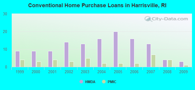
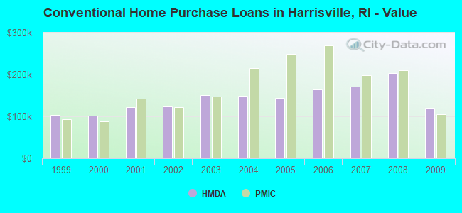
Home Mortgage Disclosure Act Aggregated Statistics For Year 2009 (Based on 1 partial tract)
A) FHA, FSA/RHS & VA Home Purchase Loans
B) Conventional Home Purchase Loans
C) Refinancings
D) Home Improvement Loans
F) Non-occupant Loans on < 5 Family Dwellings (A B C & D)
Number
Average Value
Number
Average Value
Number
Average Value
Number
Average Value
Number
Average Value
LOANS ORIGINATED
4
$182,985
3
$120,933
16
$182,022
1
$110,510
1
$66,140
APPLICATIONS APPROVED, NOT ACCEPTED
1
$139,250
0
$0
1
$155,940
0
$0
0
$0
APPLICATIONS DENIED
2
$147,805
0
$0
7
$179,363
1
$34,440
0
$0
APPLICATIONS WITHDRAWN
0
$0
0
$0
3
$193,973
0
$0
0
$0
FILES CLOSED FOR INCOMPLETENESS
0
$0
0
$0
1
$189,110
0
$0
0
$0
Aggregated Statistics For Year 2008 (Based on 1 partial tract)
A) FHA, FSA/RHS & VA Home Purchase Loans
B) Conventional Home Purchase Loans
C) Refinancings
D) Home Improvement Loans
F) Non-occupant Loans on < 5 Family Dwellings (A B C & D)
Number
Average Value
Number
Average Value
Number
Average Value
Number
Average Value
Number
Average Value
LOANS ORIGINATED
3
$212,357
4
$202,690
13
$163,546
2
$39,405
1
$157,000
APPLICATIONS APPROVED, NOT ACCEPTED
0
$0
1
$299,410
2
$246,165
0
$0
0
$0
APPLICATIONS DENIED
1
$143,260
1
$244,050
11
$207,227
2
$97,200
1
$226,940
APPLICATIONS WITHDRAWN
0
$0
1
$253,980
2
$201,790
0
$0
0
$0
FILES CLOSED FOR INCOMPLETENESS
0
$0
0
$0
1
$172,630
0
$0
0
$0
Aggregated Statistics For Year 2007 (Based on 1 partial tract)
B) Conventional Home Purchase Loans
C) Refinancings
D) Home Improvement Loans
F) Non-occupant Loans on < 5 Family Dwellings (A B C & D)
Number
Average Value
Number
Average Value
Number
Average Value
Number
Average Value
LOANS ORIGINATED
13
$170,357
19
$167,861
4
$52,402
2
$199,995
APPLICATIONS APPROVED, NOT ACCEPTED
0
$0
5
$193,002
1
$55,570
0
$0
APPLICATIONS DENIED
3
$153,757
18
$207,449
5
$64,108
0
$0
APPLICATIONS WITHDRAWN
0
$0
7
$189,989
1
$39,090
0
$0
FILES CLOSED FOR INCOMPLETENESS
0
$0
4
$236,920
0
$0
0
$0
Aggregated Statistics For Year 2006 (Based on 1 partial tract)
A) FHA, FSA/RHS & VA Home Purchase Loans
B) Conventional Home Purchase Loans
C) Refinancings
D) Home Improvement Loans
F) Non-occupant Loans on < 5 Family Dwellings (A B C & D)
Number
Average Value
Number
Average Value
Number
Average Value
Number
Average Value
Number
Average Value
LOANS ORIGINATED
1
$272,790
16
$163,652
33
$158,456
8
$73,796
3
$229,683
APPLICATIONS APPROVED, NOT ACCEPTED
0
$0
1
$102,900
6
$170,660
1
$27,890
1
$95,300
APPLICATIONS DENIED
0
$0
4
$147,698
15
$183,676
6
$61,347
2
$181,400
APPLICATIONS WITHDRAWN
0
$0
1
$174,320
16
$185,614
0
$0
1
$233,910
FILES CLOSED FOR INCOMPLETENESS
0
$0
0
$0
4
$234,702
0
$0
0
$0
Aggregated Statistics For Year 2005 (Based on 1 partial tract)
A) FHA, FSA/RHS & VA Home Purchase Loans
B) Conventional Home Purchase Loans
C) Refinancings
D) Home Improvement Loans
F) Non-occupant Loans on < 5 Family Dwellings (A B C & D)
Number
Average Value
Number
Average Value
Number
Average Value
Number
Average Value
Number
Average Value
LOANS ORIGINATED
1
$194,400
20
$143,948
41
$178,177
7
$88,111
6
$162,278
APPLICATIONS APPROVED, NOT ACCEPTED
0
$0
1
$185,940
3
$188,057
0
$0
0
$0
APPLICATIONS DENIED
0
$0
3
$194,960
15
$208,680
5
$50,162
1
$198,200
APPLICATIONS WITHDRAWN
0
$0
5
$133,626
29
$173,441
2
$144,635
3
$199,537
FILES CLOSED FOR INCOMPLETENESS
0
$0
0
$0
6
$198,868
0
$0
0
$0
Aggregated Statistics For Year 2004 (Based on 1 partial tract)
A) FHA, FSA/RHS & VA Home Purchase Loans
B) Conventional Home Purchase Loans
C) Refinancings
D) Home Improvement Loans
E) Loans on Dwellings For 5+ Families
F) Non-occupant Loans on < 5 Family Dwellings (A B C & D)
Number
Average Value
Number
Average Value
Number
Average Value
Number
Average Value
Number
Average Value
Number
Average Value
LOANS ORIGINATED
1
$237,080
16
$148,662
49
$150,829
8
$89,354
1
$199,680
5
$164,856
APPLICATIONS APPROVED, NOT ACCEPTED
0
$0
0
$0
6
$178,408
2
$68,885
0
$0
0
$0
APPLICATIONS DENIED
0
$0
3
$114,453
15
$143,318
5
$48,556
0
$0
1
$184,040
APPLICATIONS WITHDRAWN
0
$0
2
$138,720
25
$151,705
3
$55,783
0
$0
0
$0
FILES CLOSED FOR INCOMPLETENESS
0
$0
0
$0
4
$197,830
0
$0
0
$0
0
$0
Aggregated Statistics For Year 2003 (Based on 1 partial tract)
A) FHA, FSA/RHS & VA Home Purchase Loans
B) Conventional Home Purchase Loans
C) Refinancings
D) Home Improvement Loans
F) Non-occupant Loans on < 5 Family Dwellings (A B C & D)
Number
Average Value
Number
Average Value
Number
Average Value
Number
Average Value
Number
Average Value
LOANS ORIGINATED
2
$158,790
13
$150,267
89
$124,660
5
$45,768
4
$139,248
APPLICATIONS APPROVED, NOT ACCEPTED
0
$0
1
$205,380
14
$121,799
1
$58,740
1
$83,670
APPLICATIONS DENIED
0
$0
1
$181,930
21
$123,299
3
$43,597
2
$116,850
APPLICATIONS WITHDRAWN
0
$0
0
$0
27
$141,305
1
$54,090
1
$78,180
FILES CLOSED FOR INCOMPLETENESS
0
$0
0
$0
2
$142,735
0
$0
0
$0
Aggregated Statistics For Year 2002 (Based on 1 partial tract)
A) FHA, FSA/RHS & VA Home Purchase Loans
B) Conventional Home Purchase Loans
C) Refinancings
D) Home Improvement Loans
E) Loans on Dwellings For 5+ Families
F) Non-occupant Loans on < 5 Family Dwellings (A B C & D)
Number
Average Value
Number
Average Value
Number
Average Value
Number
Average Value
Number
Average Value
Number
Average Value
LOANS ORIGINATED
6
$144,283
14
$125,769
55
$115,381
4
$23,508
1
$567,340
3
$82,197
APPLICATIONS APPROVED, NOT ACCEPTED
0
$0
1
$156,780
8
$120,019
1
$36,980
0
$0
0
$0
APPLICATIONS DENIED
1
$143,260
3
$100,297
15
$95,268
3
$13,170
0
$0
1
$71,630
APPLICATIONS WITHDRAWN
0
$0
0
$0
14
$117,453
3
$17,467
0
$0
0
$0
FILES CLOSED FOR INCOMPLETENESS
0
$0
1
$112,830
1
$88,960
0
$0
0
$0
0
$0
Aggregated Statistics For Year 2001 (Based on 1 partial tract)
A) FHA, FSA/RHS & VA Home Purchase Loans
B) Conventional Home Purchase Loans
C) Refinancings
D) Home Improvement Loans
F) Non-occupant Loans on < 5 Family Dwellings (A B C & D)
Number
Average Value
Number
Average Value
Number
Average Value
Number
Average Value
Number
Average Value
LOANS ORIGINATED
6
$135,338
9
$121,287
35
$99,577
5
$28,060
1
$125,300
APPLICATIONS APPROVED, NOT ACCEPTED
0
$0
1
$105,440
6
$88,747
1
$36,770
0
$0
APPLICATIONS DENIED
0
$0
2
$111,145
17
$83,327
4
$32,487
1
$53,040
APPLICATIONS WITHDRAWN
1
$76,070
1
$38,880
11
$95,431
2
$17,645
0
$0
FILES CLOSED FOR INCOMPLETENESS
0
$0
0
$0
1
$56,840
0
$0
0
$0
Aggregated Statistics For Year 2000 (Based on 1 partial tract)
A) FHA, FSA/RHS & VA Home Purchase Loans
B) Conventional Home Purchase Loans
C) Refinancings
D) Home Improvement Loans
F) Non-occupant Loans on < 5 Family Dwellings (A B C & D)
Number
Average Value
Number
Average Value
Number
Average Value
Number
Average Value
Number
Average Value
LOANS ORIGINATED
5
$110,678
9
$101,353
15
$73,631
7
$17,689
1
$75,010
APPLICATIONS APPROVED, NOT ACCEPTED
0
$0
1
$144,110
3
$68,743
1
$6,760
0
$0
APPLICATIONS DENIED
0
$0
1
$46,910
11
$67,116
2
$36,130
0
$0
APPLICATIONS WITHDRAWN
0
$0
1
$31,480
7
$77,094
1
$19,020
0
$0
FILES CLOSED FOR INCOMPLETENESS
0
$0
0
$0
1
$55,990
0
$0
0
$0
Aggregated Statistics For Year 1999 (Based on 1 partial tract)
A) FHA, FSA/RHS & VA Home Purchase Loans
B) Conventional Home Purchase Loans
C) Refinancings
D) Home Improvement Loans
F) Non-occupant Loans on < 5 Family Dwellings (A B C & D)
Detailed PMIC statistics for the following Tracts:0129.00
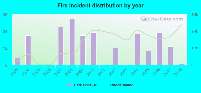
2003 - 2018 National Fire Incident Reporting System (NFIRS) incidents
According to the data from the years 2003 - 2018 the average number of fires per year is 13. The highest number of fire incidents - 33 took place in 2008, and the least - 0 in 2005. The data has a decreasing trend.
When looking into fire subcategories, the most incidents belonged to: Structure Fires (57.8%), and Outside Fires (29.9%).
Fire incident types reported to NFIRS in Harrisville, RI


 Recent articles from our blog. Our writers, many of them Ph.D. graduates or candidates, create easy-to-read articles on a wide variety of topics.

 (16.6 miles


 According to the data from the years 2003 - 2018 the average number of fires per year is 13. The highest number of fire incidents - 33 took place in 2008, and the least - 0 in 2005. The data has a decreasing trend.
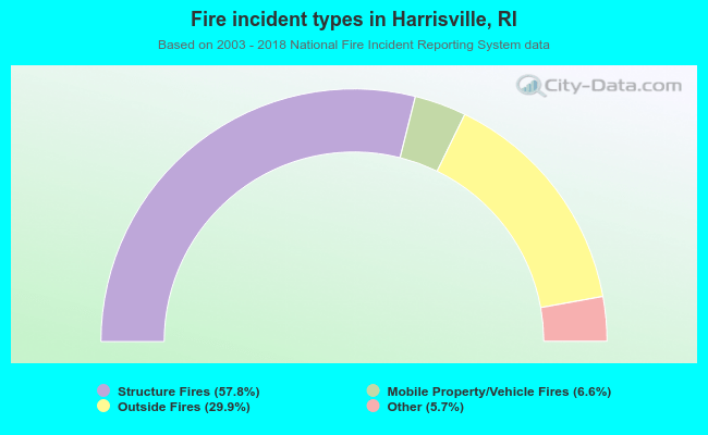 When looking into fire subcategories, the most incidents belonged to: Structure Fires (57.8%), and Outside Fires (29.9%).