Auburn, Massachusetts
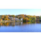
Auburn: Autumn 2009 in Auburn Massachusetts Picture taken from behind Auburn Library overlooking Auburn Pond and Auburn Street
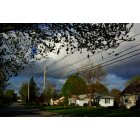
Auburn: Pakachoag Hill 5-5-11 Rainbow Here n Gone in a blink of the eye...
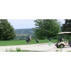
Auburn: Golfers at Packachoag Golf Course July 2009
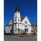
Auburn: Town Hall Auburn, MA
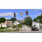
Auburn: My Home Town - 3 Way Intersection: Pakachoag-Milllbury & Auburn Street
- add
your
Submit your own pictures of this town and show them to the world
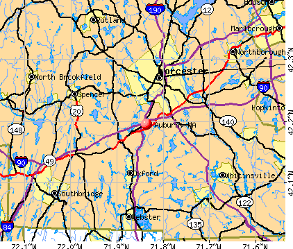
- OSM Map
- General Map
- Google Map
- MSN Map
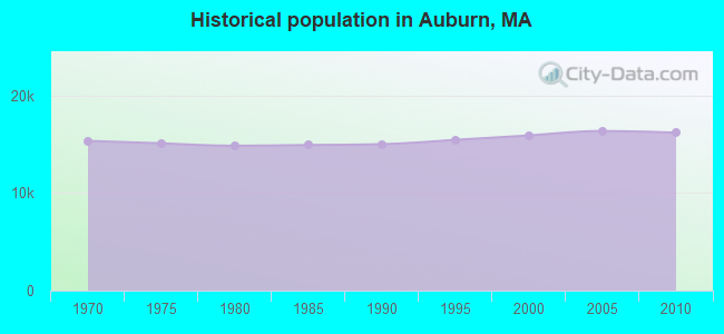
Population change since 2000: +1.8%
 |
| Males: 7,806 | |
| Females: 8,382 |
| Median resident age: | 43.7 years |
| Massachusetts median age: | 39.2 years |
Zip codes: 01501.
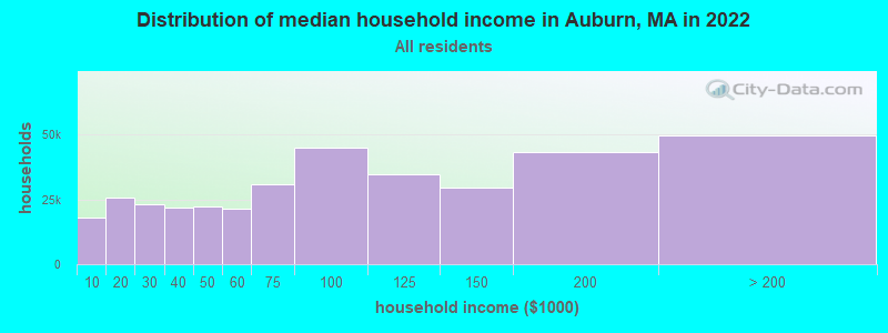
| Auburn: | $93,247 |
| MA: | $94,488 |
Estimated per capita income in 2022: $46,409 (it was $23,802 in 2000)
Auburn town income, earnings, and wages data
Estimated median house or condo value in 2022: $373,641 (it was $135,300 in 2000)
| Auburn: | $373,641 |
| MA: | $534,700 |
Mean prices in 2022: all housing units: $419,164; detached houses: $447,621; townhouses or other attached units: $343,592; in 2-unit structures: $323,295; in 3-to-4-unit structures: $332,295; in 5-or-more-unit structures: $232,758; mobile homes: $113,885
Detailed information about poverty and poor residents in Auburn, MA


- 15,08293.2%White alone
- 4262.6%Hispanic
- 2991.8%Asian alone
- 1831.1%Two or more races
- 1541.0%Black alone
- 210.1%American Indian alone
- 200.1%Other race alone
- 30.02%Native Hawaiian and Other
Pacific Islander alone
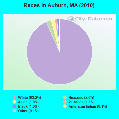
Races in Auburn detailed stats: ancestries, foreign born residents, place of birth
According to our research of Massachusetts and other state lists, there were 10 registered sex offenders living in Auburn, Massachusetts as of May 07, 2024.
The ratio of all residents to sex offenders in Auburn is 1,619 to 1.
The ratio of registered sex offenders to all residents in this city is near the state average.
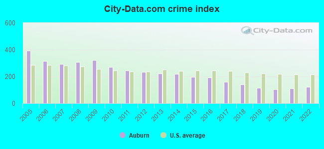
Type |
2009 |
2010 |
2011 |
2012 |
2013 |
2014 |
2015 |
2016 |
2017 |
2018 |
2019 |
2020 |
2021 |
2022 |
|---|---|---|---|---|---|---|---|---|---|---|---|---|---|---|
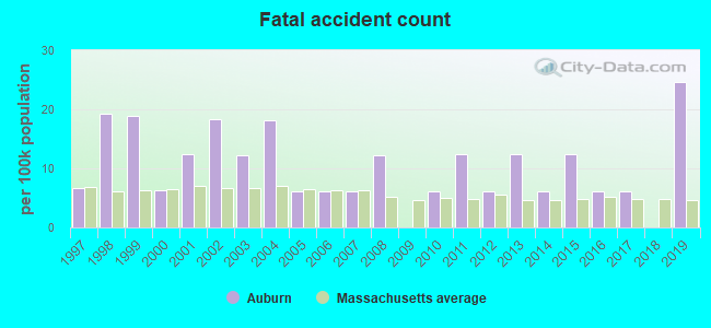
| Murders (per 100,000) | 0 (0.0) | 0 (0.0) | 0 (0.0) | 0 (0.0) | 0 (0.0) | 1 (6.1) | 1 (6.1) | 1 (6.1) | 0 (0.0) | 1 (6.0) | 0 (0.0) | 0 (0.0) | 0 (0.0) | 0 (0.0) |
| Rapes (per 100,000) | 5 (30.5) | 2 (12.4) | 2 (12.3) | 3 (18.3) | 4 (24.4) | 4 (24.4) | 3 (18.2) | 4 (24.2) | 4 (24.2) | 3 (17.9) | 0 (0.0) | 1 (6.0) | 3 (17.8) | 2 (11.8) |
| Robberies (per 100,000) | 8 (48.7) | 11 (68.0) | 7 (43.0) | 3 (18.3) | 7 (42.8) | 4 (24.4) | 6 (36.5) | 4 (24.2) | 2 (12.1) | 1 (6.0) | 1 (6.0) | 2 (12.0) | 3 (17.8) | 4 (23.7) |
| Assaults (per 100,000) | 98 (596.8) | 46 (284.2) | 42 (257.9) | 42 (256.3) | 36 (220.0) | 32 (195.2) | 35 (212.9) | 37 (224.1) | 35 (211.3) | 24 (143.1) | 27 (161.4) | 23 (137.4) | 19 (112.5) | 29 (171.8) |
| Burglaries (per 100,000) | 65 (395.9) | 93 (574.5) | 69 (423.7) | 74 (451.5) | 77 (470.6) | 85 (518.5) | 51 (310.2) | 36 (218.1) | 33 (199.2) | 28 (167.0) | 29 (173.4) | 21 (125.5) | 24 (142.1) | 23 (136.3) |
| Thefts (per 100,000) | 518 (3,155) | 525 (3,243) | 519 (3,187) | 494 (3,014) | 438 (2,677) | 390 (2,379) | 351 (2,135) | 355 (2,150) | 302 (1,823) | 282 (1,681) | 263 (1,573) | 200 (1,195) | 233 (1,380) | 233 (1,380) |
| Auto thefts (per 100,000) | 18 (109.6) | 26 (160.6) | 25 (153.5) | 20 (122.0) | 16 (97.8) | 15 (91.5) | 16 (97.3) | 18 (109.0) | 15 (90.6) | 9 (53.7) | 13 (77.7) | 19 (113.5) | 10 (59.2) | 13 (77.0) |
| Arson (per 100,000) | 3 (18.3) | 3 (18.5) | 2 (12.3) | 4 (24.4) | 1 (6.1) | 1 (6.1) | 1 (6.1) | 1 (6.1) | 3 (18.1) | 3 (17.9) | 3 (17.9) | 0 (0.0) | 2 (11.8) | 1 (5.9) |
| City-Data.com crime index | 321.0 | 269.9 | 243.7 | 233.3 | 224.3 | 216.9 | 195.2 | 193.6 | 159.3 | 139.9 | 115.3 | 101.5 | 111.9 | 121.9 |
The City-Data.com crime index weighs serious crimes and violent crimes more heavily. Higher means more crime, U.S. average is 246.1. It adjusts for the number of visitors and daily workers commuting into cities.
Crime rate in Auburn detailed stats: murders, rapes, robberies, assaults, burglaries, thefts, arson
Full-time law enforcement employees in 2021, including police officers: 48 (37 officers - 35 male; 2 female).
| Officers per 1,000 residents here: | 2.19 |
| Massachusetts average: | 2.53 |
 Recent articles from our blog. Our writers, many of them Ph.D. graduates or candidates, create easy-to-read articles on a wide variety of topics.

 | Cars in MA (789 replies) |
| 2021 Real Estate Observations (1729 replies) |
| Twice exceptional student - best public school district in MA? (48 replies) |
| Now a stabbing at the Auburn Mall (6 replies) |
| Why is BPS so bad and what should be done to improve it? (589 replies) |
| Moving Small Family to Worcester. Advice? (25 replies) |
Latest news from Auburn, MA collected exclusively by city-data.com from local newspapers, TV, and radio stations
Ancestries: Irish (26.1%), French (18.9%), Italian (15.2%), English (13.4%), French Canadian (8.4%), Swedish (8.2%).
Current Local Time: EST time zone
Incorporated in 1778
Elevation: 603 feet
Land area: 15.4 square miles.
Population density: 1,054 people per square mile (low).
554 residents are foreign born (1.6% Europe, 0.7% Asia, 0.5% Latin America, 0.5% North America).
| This town: | 3.5% |
| Massachusetts: | 12.2% |
| Auburn town: | 1.1% ($1,442) |
| Massachusetts: | 1.3% ($2,336) |
Nearest city with pop. 50,000+: Worcester, MA  (4.8 miles , pop. 172,648).
Nearest city with pop. 200,000+: Boston, MA (39.2 miles , pop. 589,141).
Nearest city with pop. 1,000,000+: Bronx, NY (141.1 miles , pop. 1,332,650).
Nearest cities:
), Latitude: 42.20 N, Longitude: 71.84 W
Area codes: 508, 774
Auburn tourist attractions:
Auburn, Massachusetts accommodation & food services, waste management - Economy and Business Data
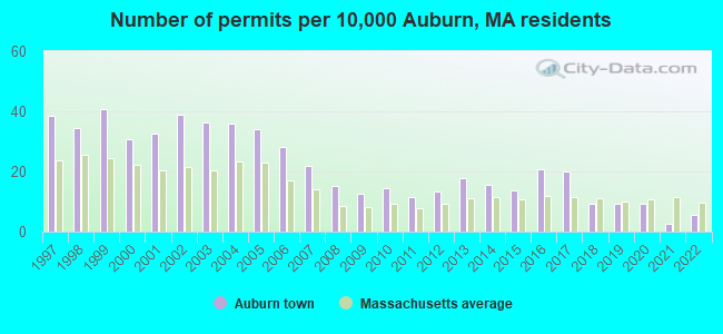
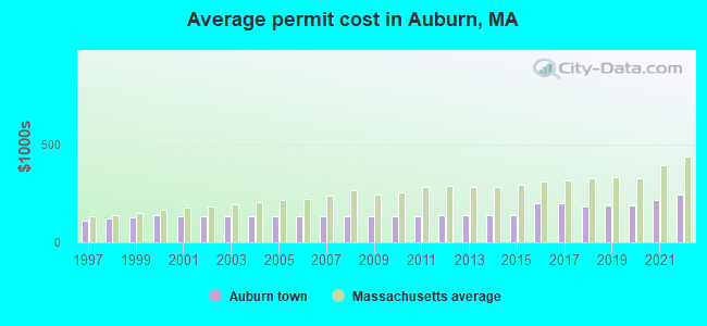
Single-family new house construction building permits:
- 2022: 9 buildings, average cost: $244,600
- 2021: 4 buildings, average cost: $215,300
- 2020: 15 buildings, average cost: $188,100
- 2019: 15 buildings, average cost: $188,100
- 2018: 15 buildings, average cost: $180,300
- 2017: 32 buildings, average cost: $199,500
- 2016: 33 buildings, average cost: $199,500
- 2015: 22 buildings, average cost: $137,200
- 2014: 25 buildings, average cost: $137,200
- 2013: 28 buildings, average cost: $137,100
- 2012: 21 buildings, average cost: $137,700
- 2011: 18 buildings, average cost: $133,400
- 2010: 23 buildings, average cost: $133,400
- 2009: 20 buildings, average cost: $133,400
- 2008: 24 buildings, average cost: $133,400
- 2007: 35 buildings, average cost: $133,400
- 2006: 45 buildings, average cost: $133,400
- 2005: 54 buildings, average cost: $133,300
- 2004: 57 buildings, average cost: $133,400
- 2003: 58 buildings, average cost: $133,200
- 2002: 62 buildings, average cost: $133,800
- 2001: 52 buildings, average cost: $130,000
- 2000: 49 buildings, average cost: $136,200
- 1999: 65 buildings, average cost: $125,300
- 1998: 55 buildings, average cost: $118,500
- 1997: 61 buildings, average cost: $110,400
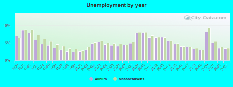
| Here: | 3.4% |
| Massachusetts: | 3.5% |
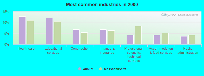
- Health care (12.7%)
- Educational services (12.2%)
- Construction (6.9%)
- Finance & insurance (6.8%)
- Professional, scientific, technical services (4.3%)
- Accommodation & food services (4.2%)
- Public administration (3.7%)
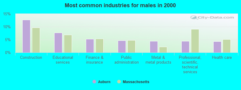
- Construction (12.7%)
- Educational services (7.6%)
- Finance & insurance (5.2%)
- Public administration (4.7%)
- Metal & metal products (4.5%)
- Professional, scientific, technical services (4.4%)
- Health care (4.4%)
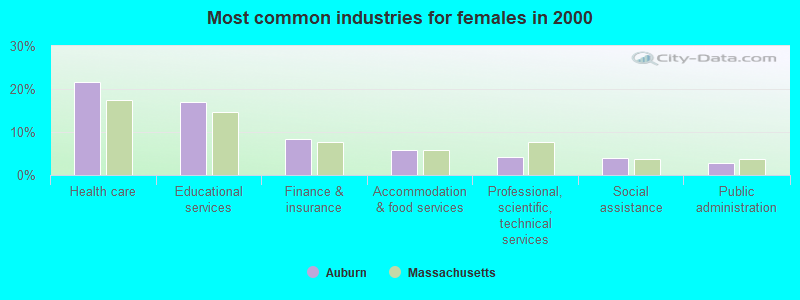
- Health care (21.6%)
- Educational services (17.0%)
- Finance & insurance (8.5%)
- Accommodation & food services (5.8%)
- Professional, scientific, technical services (4.2%)
- Social assistance (3.9%)
- Public administration (2.7%)
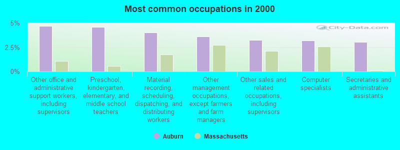
- Other office and administrative support workers, including supervisors (4.7%)
- Preschool, kindergarten, elementary, and middle school teachers (4.6%)
- Material recording, scheduling, dispatching, and distributing workers (4.0%)
- Other management occupations, except farmers and farm managers (3.6%)
- Other sales and related occupations, including supervisors (3.3%)
- Computer specialists (3.2%)
- Secretaries and administrative assistants (3.0%)
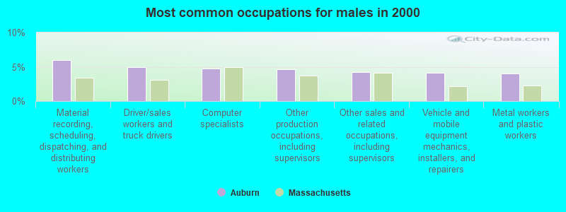
- Material recording, scheduling, dispatching, and distributing workers (6.0%)
- Driver/sales workers and truck drivers (5.0%)
- Computer specialists (4.8%)
- Other production occupations, including supervisors (4.6%)
- Other sales and related occupations, including supervisors (4.2%)
- Vehicle and mobile equipment mechanics, installers, and repairers (4.1%)
- Metal workers and plastic workers (4.0%)
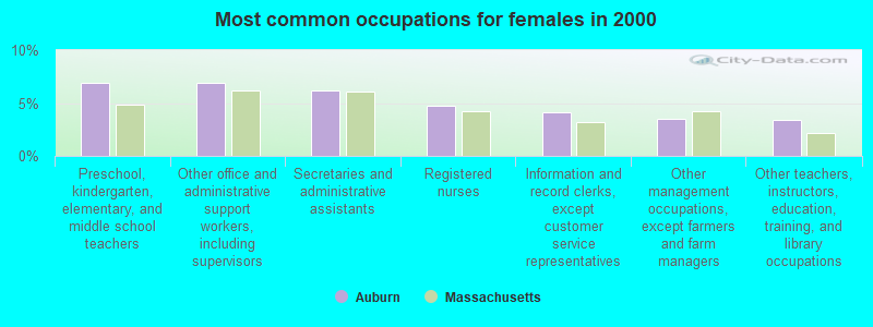
- Preschool, kindergarten, elementary, and middle school teachers (6.9%)
- Other office and administrative support workers, including supervisors (6.9%)
- Secretaries and administrative assistants (6.2%)
- Registered nurses (4.8%)
- Information and record clerks, except customer service representatives (4.1%)
- Other management occupations, except farmers and farm managers (3.5%)
- Other teachers, instructors, education, training, and library occupations (3.4%)
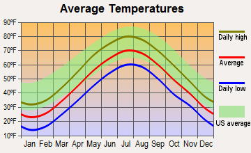
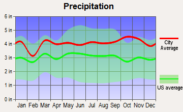
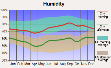
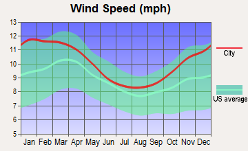
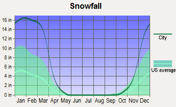
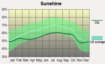
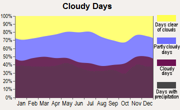
Average climate in Auburn, Massachusetts
Based on data reported by over 4,000 weather stations
(lower is better)
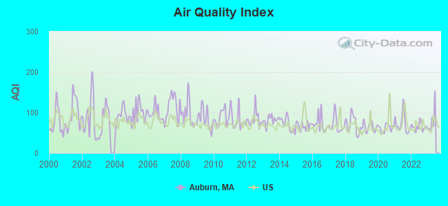
Air Quality Index (AQI) level in 2022 was 64.6. This is about average.
| City: | 64.6 |
| U.S.: | 72.6 |
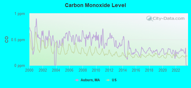
Carbon Monoxide (CO) [ppm] level in 2022 was 0.259. This is about average. Closest monitor was 4.3 miles away from the city center.
| City: | 0.259 |
| U.S.: | 0.251 |
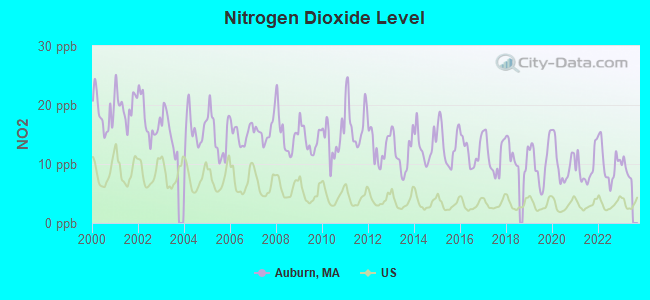
Nitrogen Dioxide (NO2) [ppb] level in 2022 was 10.1. This is significantly worse than average. Closest monitor was 3.3 miles away from the city center.
| City: | 10.1 |
| U.S.: | 5.1 |
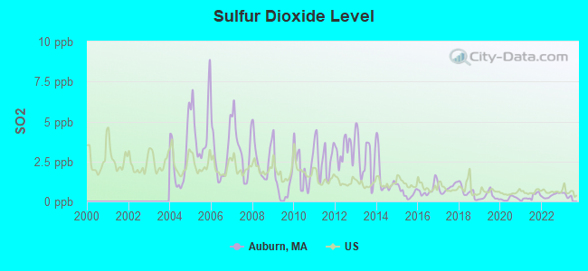
Sulfur Dioxide (SO2) [ppb] level in 2022 was 0.370. This is significantly better than average. Closest monitor was 3.3 miles away from the city center.
| City: | 0.370 |
| U.S.: | 1.515 |
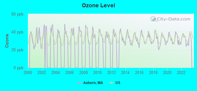
Ozone [ppb] level in 2022 was 31.7. This is about average. Closest monitor was 4.3 miles away from the city center.
| City: | 31.7 |
| U.S.: | 33.3 |
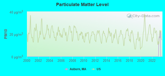
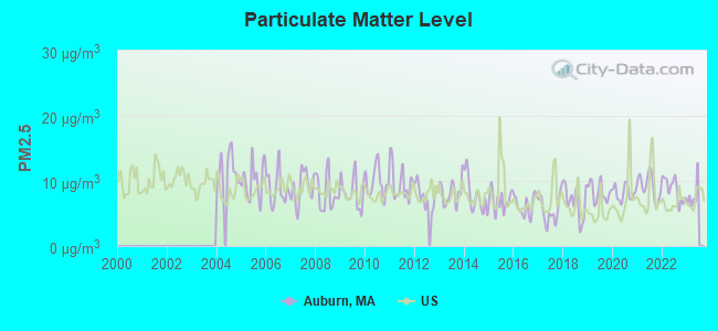
Particulate Matter (PM2.5) [µg/m3] level in 2022 was 8.71. This is about average. Closest monitor was 4.4 miles away from the city center.
| City: | 8.71 |
| U.S.: | 8.11 |
Tornado activity:
Auburn-area historical tornado activity is slightly above Massachusetts state average. It is 21% smaller than the overall U.S. average.
On 6/9/1953, a category F4 (max. wind speeds 207-260 mph) tornado 17.6 miles away from the Auburn town center killed 90 people and injured 1228 people and caused between $50,000,000 and $500,000,000 in damages.
On 6/9/1953, a category F3 (max. wind speeds 158-206 mph) tornado 4.2 miles away from the town center injured 17 people and caused between $500,000 and $5,000,000 in damages.
Earthquake activity:
Auburn-area historical earthquake activity is significantly above Massachusetts state average. It is 72% smaller than the overall U.S. average.On 10/7/1983 at 10:18:46, a magnitude 5.3 (5.1 MB, 5.3 LG, 5.1 ML, Class: Moderate, Intensity: VI - VII) earthquake occurred 175.0 miles away from the city center
On 4/20/2002 at 10:50:47, a magnitude 5.3 (5.3 ML, Depth: 3.0 mi) earthquake occurred 185.0 miles away from Auburn center
On 4/20/2002 at 10:50:47, a magnitude 5.2 (5.2 MB, 4.2 MS, 5.2 MW, 5.0 MW) earthquake occurred 184.1 miles away from the city center
On 1/19/1982 at 00:14:42, a magnitude 4.7 (4.5 MB, 4.7 MD, 4.5 LG, Class: Light, Intensity: IV - V) earthquake occurred 90.5 miles away from the city center
On 10/16/2012 at 23:12:25, a magnitude 4.7 (4.7 ML, Depth: 10.0 mi) earthquake occurred 113.5 miles away from Auburn center
On 8/22/1992 at 12:20:32, a magnitude 4.8 (4.8 MB, 3.8 MS, 4.7 LG, Depth: 6.2 mi) earthquake occurred 228.6 miles away from the city center
Magnitude types: regional Lg-wave magnitude (LG), body-wave magnitude (MB), duration magnitude (MD), local magnitude (ML), surface-wave magnitude (MS), moment magnitude (MW)
Natural disasters:
The number of natural disasters in Worcester County (27) is a lot greater than the US average (15).Major Disasters (Presidential) Declared: 15
Emergencies Declared: 12
Causes of natural disasters: Floods: 9, Storms: 8, Hurricanes: 6, Snowstorms: 5, Winter Storms: 4, Blizzards: 2, Snows: 2, Fire: 1, Heavy Rain: 1, Snowfall: 1, Tornado: 1, Wind: 1 (Note: some incidents may be assigned to more than one category).
Hospitals and medical centers in Auburn:
Other hospitals and medical centers near Auburn:
- INTERIM HEALTH CARE OF WORCESTER (Home Health Center, about 3 miles away; WORCESTER, MA)
- ACCLAIM HOME HEALTH CARE, INC (Home Health Center, about 3 miles away; WORCESTER, MA)
- PARSONS HILL NURSING AND REHABILITATION CENTER (Nursing Home, about 3 miles away; WORCESTER, MA)
- EVANS MANOR NURSING HOME (Nursing Home, about 4 miles away; WORCESTER, MA)
- KINDRED TRANSITIONAL CARE AND REHAB-THE MEADOWS (Nursing Home, about 4 miles away; ROCHDALE, MA)
- MILL HILL NURSING HOME (Nursing Home, about 4 miles away; WORCESTER, MA)
- MILL HILL SENIOR CARE, LLC (Nursing Home, about 4 miles away; WORCESTER, MA)
Amtrak station near Auburn:
Colleges/universities with over 2000 students nearest to Auburn:
- College of the Holy Cross (about 3 miles; Worcester, MA; Full-time enrollment: 3,125)
- Clark University (about 4 miles; Worcester, MA; FT enrollment: 3,687)
- Worcester State University (about 5 miles; Worcester, MA; FT enrollment: 5,426)
- Worcester Polytechnic Institute (about 6 miles; Worcester, MA; FT enrollment: 3,930)
- Assumption College (about 7 miles; Worcester, MA; FT enrollment: 2,580)
- Quinsigamond Community College (about 9 miles; Worcester, MA; FT enrollment: 5,877)
- Framingham State University (about 22 miles; Framingham, MA; FT enrollment: 5,743)
Public high school in Auburn:
- AUBURN SENIOR HIGH (Students: 671, Location: 99 AUBURN STREET, Grades: PK-12)
Public elementary/middle schools in Auburn:
- AUBURN MIDDLE (Students: 583, Location: 10 SWANSON ROAD, Grades: 6-8)
- MARY D STONE (Students: 308, Location: 10 CHURCH STREET, Grades: KG-2)
- JULIA BANCROFT (Students: 266, Location: 3 VINAL STREET, Grades: 3-5)
- PAKACHOAG (Students: 253, Location: 110 PAKACHOAG STREET, Grades: 3-5)
- BRYN MAWR (Students: 242, Location: 35 SWANSON ROAD, Grades: KG-2)
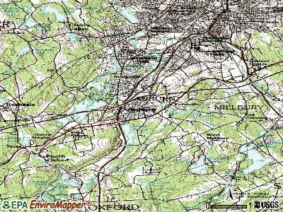
Points of interest:
Notable locations in Auburn: Auburn Industrial Park (A), Pakachoag Golf Course (B), Auburn Plaza (C), Drury Square (D), Federal Plaza (E), Auburn Fire Department Station 2 (F), Auburn Fire Department Station 1 Headquarters (G), Auburn Town Hall (H), Stevens Building (I), Horgan Skating Arena (J). Display/hide their locations on the map
Shopping Centers: Auburn Mall Shopping Center (1), Auburn Plaza Shopping Center (2), Federal Plaza Shopping Center (3), Heritage Mall Shopping Center (4), The Fair Shopping Plaza Shopping Center (5), The Fair Shopping Center (6), Auburn Mall (7). Display/hide their locations on the map
Churches in Auburn include: Pakachoag Church (A), Saint Thomas Episcopal Church (B), Pakachoag Church (C), Kingdom Hall of Jehovahs Witnesses Church (D), First Congregational Church (E), Faith Baptist Church (F), Church of God Southern New England (G), Bethel Lutheran Church (H), Berean Baptist Church (I). Display/hide their locations on the map
Cemeteries: Hebrew Cemetery (1), Auburn Cemetery (2), Hillside Cemetery (3). Display/hide their locations on the map
Reservoirs: Stoneville Reservoir (A), Stoneville Pond (B), Pondville Pond (C), Leesville Pond (D), Eddy Pond (E), Auburn Pond (F), Dark Brook (G). Display/hide their locations on the map
Streams, rivers, and creeks: Stoneville Brook (A), Chapin Brook (B), Kinnear Brook (C), Ramshorn Brook (D), Stone Brook (E). Display/hide their locations on the map
Park in Auburn: Boyce Street Park (1). Display/hide its location on the map
Tourist attractions: Auburn Historical Society (Cultural Attractions- Events- & Facilities; 41 South Street), Amf Bowling Centers - Amf Auburn Lanes (Amusement & Theme Parks; 101 Southbridge Street).
Hotels: Hampton Inn Auburn (736 Southbridge Street), Comfort Inn Auburn (426 Southbridge Street), Fairfield Inn & Suites Worcester Auburn (718 A Southbridge Street), Best Western Yankee Drummer Inn (624 Southbridge), Hampton Inn-Auburn (736 Southbridge Street), Baymomt Inn & Suites - Auburn (446 Southbridge St), Days Inn (426 Southbridge Street), Budgetel Inn (444 Southbridge Street), Auburn Motel (1 Buckley Drive).
Birthplace of: Jeff Fuller - Nextel Cup series NASCAR driver (born: Mar 27, 1957), Jeffrey Lynn - Film actor, Javier Mojica - College basketball player (Central Conn. Blue Devils), Pat Murphy (baseball) - Baseball player, Dick Lamby - Ice hockey player.
Drinking water stations with addresses in Auburn and their reported violations in the past:
AUBURN WATER DISTRICT (Population served: 11,527, Purch surface water):Past health violations:ELM HILL WATER DISTRICT (Population served: 2,194, Purch surface water):Past monitoring violations:
- MCL, Monthly (TCR) - In SEP-2013, Contaminant: Coliform. Follow-up actions: St AO (w/o penalty) issued (NOV-26-2013), St Compliance achieved (NOV-26-2013)
- MCL, Average - Between APR-2013 and JUN-2013, Contaminant: Arsenic. Follow-up actions: St AO (w/penalty) issued (NOV-07-2013)
- MCL, Average - Between JAN-2013 and MAR-2013, Contaminant: Arsenic. Follow-up actions: St AO (w/o penalty) issued (MAY-13-2013)
- MCL, Average - Between OCT-2012 and DEC-2012, Contaminant: Arsenic. Follow-up actions: St AO (w/o penalty) issued (NOV-21-2012)
- MCL, Average - Between JUL-2012 and SEP-2012, Contaminant: Arsenic. Follow-up actions: St AO (w/o penalty) issued (NOV-21-2012)
- MCL, Monthly (TCR) - In OCT-2010, Contaminant: Coliform. Follow-up actions: St AO (w/o penalty) issued (FEB-04-2011), St Compliance achieved (JUN-27-2013)
- Follow-up Or Routine LCR Tap M/R - In JUL-01-2012, Contaminant: Lead and Copper Rule. Follow-up actions: St AO (w/o penalty) issued (DEC-05-2012), St Compliance achieved (OCT-17-2013)
- 23 regular monitoring violations
Past monitoring violations:
- Follow-up Or Routine LCR Tap M/R - In JUL-01-2007, Contaminant: Lead and Copper Rule. Follow-up actions: St AO (w/o penalty) issued (AUG-29-2007), St Compliance achieved (2 times from NOV-30-2007 to JUN-09-2008)
| This town: | 2.5 people |
| Massachusetts: | 2.5 people |
| This town: | 66.4% |
| Whole state: | 63.0% |
| This town: | 6.3% |
| Whole state: | 7.0% |
Likely homosexual households (counted as self-reported same-sex unmarried-partner households)
- Lesbian couples: 0.5% of all households
- Gay men: 0.5% of all households
| This town: | 3.3% |
| Whole state: | 9.3% |
| This town: | 1.2% |
| Whole state: | 4.4% |
People in group quarters in Auburn in 2010:
- 135 people in nursing facilities/skilled-nursing facilities
- 11 people in group homes intended for adults
- 3 people in other noninstitutional facilities
People in group quarters in Auburn in 2000:
- 144 people in nursing homes
- 4 people in homes for the physically handicapped
- 2 people in religious group quarters
Banks with branches in Auburn (2011 data):
- Bay State Savings Bank: Minuteman Plaza Branch at 123 Auburn Street, branch established on 1998/06/15; Auburn High School Branch at 99 Auburn Street, branch established on 1989/09/18. Info updated 2011/08/17: Bank assets: $268.4 mil, Deposits: $214.3 mil, headquarters in Worcester, MA, positive income, Commercial Lending Specialization, 8 total offices, Holding Company: 1895 Mhc
- Webster Five Cents Savings Bank: Auburn Branch at 400 Southbridge Street, branch established on 1994/10/31. Info updated 2009/05/20: Bank assets: $558.9 mil, Deposits: $465.4 mil, headquarters in Webster, MA, positive income, Commercial Lending Specialization, 8 total offices, Holding Company: Webfive Mhc
- Savers Co-operative Bank: Auburn Branch at 42 Auburn Street, branch established on 1958/05/01. Info updated 2011/08/19: Bank assets: $414.6 mil, Deposits: $307.9 mil, headquarters in Southbridge, MA, positive income, Mortgage Lending Specialization, 6 total offices
- TD Bank, National Association: Auburn Branch at 614 Southbridge Street, branch established on 1934/01/01. Info updated 2010/10/04: Bank assets: $188,912.6 mil, Deposits: $153,149.8 mil, headquarters in Wilmington, DE, positive income, 1314 total offices, Holding Company: Toronto-Dominion Bank, The
- The Bank of Canton: Auburn Loan Production Office at 850 Southbridge Street, branch established on 2007/12/13. Info updated 2009/02/04: Bank assets: $634.2 mil, Deposits: $543.9 mil, headquarters in Canton, MA, positive income, Commercial Lending Specialization, 9 total offices, Holding Company: Ponkapoag Bancorp, Mhc
- Bank of America, National Association: Auburn Branch at 379 Southbridge Street, branch established on 1970/06/22. Info updated 2009/11/18: Bank assets: $1,451,969.3 mil, Deposits: $1,077,176.8 mil, headquarters in Charlotte, NC, positive income, 5782 total offices, Holding Company: Bank Of America Corporation
- Sovereign Bank, National Association: Auburn Branch at 317 Washington St, branch established on 1957/04/29. Info updated 2012/01/31: Bank assets: $78,146.9 mil, Deposits: $48,042.9 mil, headquarters in Wilmington, DE, positive income, Commercial Lending Specialization, 718 total offices, Holding Company: Banco Santander, S.A.
For population 15 years and over in Auburn:
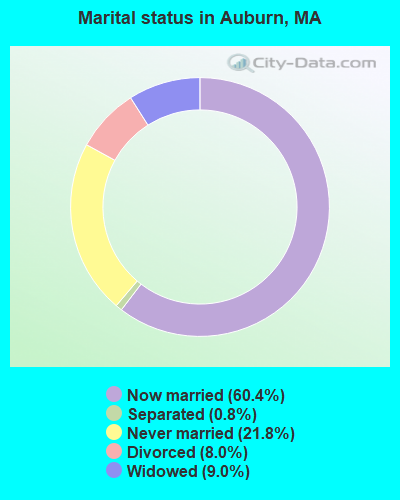
- Never married: 21.8%
- Now married: 60.4%
- Separated: 0.8%
- Widowed: 9.0%
- Divorced: 8.0%
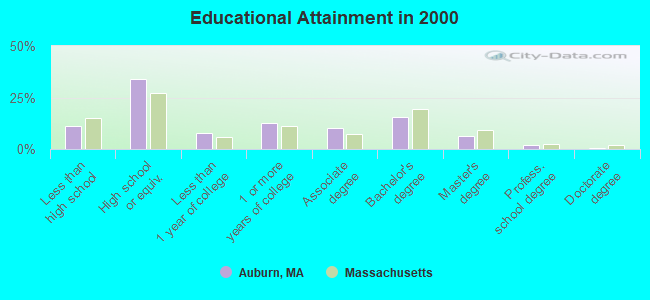
For population 25 years and over in Auburn:
- High school or higher: 88.8%
- Bachelor's degree or higher: 24.2%
- Graduate or professional degree: 8.7%
- Unemployed: 2.4%
- Mean travel time to work (commute): 21.9 minutes
| Here: | 10.2 |
| Massachusetts average: | 13.1 |


Graphs represent county-level data. Detailed 2008 Election Results
Religion statistics for Auburn, MA (based on Worcester County data)


| Religion | Adherents | Congregations |
|---|---|---|
| Catholic | 306,925 | 118 |
| Mainline Protestant | 43,326 | 171 |
| Evangelical Protestant | 37,511 | 203 |
| Other | 18,931 | 69 |
| Orthodox | 7,935 | 15 |
| Black Protestant | 497 | 6 |
| None | 383,427 | - |
Food Environment Statistics:
| Worcester County: | 1.73 / 10,000 pop. |
| Massachusetts: | 1.98 / 10,000 pop. |
| This county: | 0.05 / 10,000 pop. |
| State: | 0.05 / 10,000 pop. |
| Worcester County: | 1.79 / 10,000 pop. |
| Massachusetts: | 2.22 / 10,000 pop. |
| Worcester County: | 2.22 / 10,000 pop. |
| State: | 1.77 / 10,000 pop. |
| Here: | 7.27 / 10,000 pop. |
| State: | 8.76 / 10,000 pop. |
| This county: | 8.0% |
| Massachusetts: | 8.1% |
| Worcester County: | 24.0% |
| Massachusetts: | 22.5% |
| This county: | 16.6% |
| State: | 16.5% |
4.71% of this county's 2021 resident taxpayers lived in other counties in 2020 ($76,229 average adjusted gross income)
| Here: | 4.71% |
| Massachusetts average: | 6.35% |
0.02% of residents moved from foreign countries ($100 average AGI)
Worcester County: 0.02% Massachusetts average: 0.01%
Top counties from which taxpayers relocated into this county between 2020 and 2021:
| from Middlesex County, MA | |
| from Norfolk County, MA | |
| from Suffolk County, MA |
4.84% of this county's 2020 resident taxpayers moved to other counties in 2021 ($87,252 average adjusted gross income)
| Here: | 4.84% |
| Massachusetts average: | 7.18% |
0.03% of residents moved to foreign countries ($199 average AGI)
Worcester County: 0.03% Massachusetts average: 0.02%
Top counties to which taxpayers relocated from this county between 2020 and 2021:
| to Middlesex County, MA | |
| to Norfolk County, MA | |
| to Suffolk County, MA |
| Businesses in Auburn, MA | ||||
| Name | Count | Name | Count | |
|---|---|---|---|---|
| ALDO | 1 | KFC | 1 | |
| AMF Bowling | 1 | La Quinta | 1 | |
| AT&T | 1 | LensCrafters | 1 | |
| Aeropostale | 1 | Macy's | 1 | |
| American Eagle Outfitters | 1 | Marriott | 1 | |
| Applebee's | 1 | McDonald's | 2 | |
| Arby's | 1 | Men's Wearhouse | 1 | |
| AutoZone | 1 | Motherhood Maternity | 2 | |
| Bath & Body Works | 1 | New York & Co | 1 | |
| Bed Bath & Beyond | 1 | Nike | 2 | |
| Burger King | 1 | Nissan | 1 | |
| CVS | 1 | Outback | 1 | |
| Charlotte Russe | 1 | Outback Steakhouse | 1 | |
| Chevrolet | 1 | Pac Sun | 1 | |
| Comfort Inn | 1 | Payless | 2 | |
| Dairy Queen | 1 | Penske | 1 | |
| Dunkin Donuts | 4 | RadioShack | 1 | |
| Express | 1 | Ryder Rental & Truck Leasing | 1 | |
| Famous Footwear | 1 | Sears | 3 | |
| FedEx | 4 | Shaw's | 1 | |
| Finish Line | 1 | Spencer Gifts | 1 | |
| Firestone Complete Auto Care | 1 | Sprint Nextel | 2 | |
| Foot Locker | 1 | Staples | 1 | |
| Ford | 1 | Starbucks | 1 | |
| Forever 21 | 1 | Subway | 1 | |
| GNC | 1 | T-Mobile | 2 | |
| GameStop | 1 | T.J.Maxx | 1 | |
| Gymboree | 1 | Taco Bell | 1 | |
| H&R Block | 1 | Toyota | 1 | |
| Hilton | 1 | Toys"R"Us | 1 | |
| Holiday Inn | 1 | U-Haul | 5 | |
| Hollister Co. | 1 | UPS | 6 | |
| Home Depot | 1 | Vans | 1 | |
| Honda | 1 | Verizon Wireless | 1 | |
| Hot Topic | 1 | Victoria's Secret | 1 | |
| Hyundai | 1 | Volkswagen | 1 | |
| Jones New York | 3 | Wendy's | 1 | |
| Journeys | 1 | Wet Seal | 1 | |
Strongest AM radio stations in Auburn:
- WCRN (830 AM; 50 kW; WORCESTER, MA; Owner: CARTER BROADCASTING CORPORATION)
- WORC (1310 AM; 5 kW; WORCESTER, MA; Owner: CHOWDER BROADCAST GROUP LLC)
- WVNE (760 AM; daytime; 25 kW; LEICESTER, MA; Owner: BLOUNT MASSCOM, INC.)
- WALE (990 AM; 50 kW; GREENVILLE, RI; Owner: NORTH AMERICAN BROADCASTING CO., INC.)
- WVEI (1440 AM; 5 kW; WORCESTER, MA; Owner: ENTERCOM BOSTON LICENSE, LLC)
- WTAG (580 AM; 5 kW; WORCESTER, MA; Owner: CAPSTAR TX LIMITED PARTNERSHIP)
- WKOX (1200 AM; 50 kW; FRAMINGHAM, MA; Owner: CAPSTAR TX LIMITED PARTNERSHIP)
- WBIX (1060 AM; 40 kW; NATICK, MA; Owner: LANGER BROADCASTING CORPORATION)
- WEEI (850 AM; 50 kW; BOSTON, MA; Owner: ENTERCOM BOSTON LICENSE, LLC)
- WAMG (890 AM; 25 kW; DEDHAM, MA; Owner: MEGA COMMUNICATIONS OF DEDHAM LICENSEE, LLC)
- WRKO (680 AM; 50 kW; BOSTON, MA; Owner: ENTERCOM BOSTON LICENSE, LLC)
- WNEB (1230 AM; 1 kW; WORCESTER, MA; Owner: GRACE BROADCASTING CORPORATION)
- WNNZ (640 AM; 50 kW; WESTFIELD, MA; Owner: CLEAR CHANNEL BROADCASTING LICENSES, INC.)
Strongest FM radio stations in Auburn:
- WAAF (107.3 FM; WORCESTER, MA; Owner: ENTERCOM BOSTON LICENSE, LLC)
- WSRS (96.1 FM; WORCESTER, MA; Owner: CAPSTAR TX LIMITED PARTNERSHIP)
- WICN (90.5 FM; WORCESTER, MA; Owner: WICN PUBLIC RADIO, INC)
- WYCM (90.1 FM; CHARLTON, MA; Owner: BAY PATH VOCATIONAL HIGH SCHOOL)
- WBPR (91.9 FM; WORCESTER, MA; Owner: UNIVERSITY OF MASSACHUSETTS)
- WCUW (91.3 FM; WORCESTER, MA; Owner: WUW, INC.)
- WWFX (100.1 FM; SOUTHBRIDGE, MA; Owner: CITADEL BROADCASTING COMPANY)
- WORC-FM (98.9 FM; WEBSTER, MA; Owner: CITADEL BROADCASTING COMPANY)
- WXLO (104.5 FM; FITCHBURG, MA; Owner: CITADEL BROADCASTING COMPANY)
- WBMX (98.5 FM; BOSTON, MA; Owner: INFINITY RADIO OPERATIONS INC.)
- WJMN (94.5 FM; BOSTON, MA; Owner: AMFM RADIO LICENSES, L.L.C.)
- WCRB (102.5 FM; WALTHAM, MA; Owner: CHARLES RIVER BROADCASTING WCRB LICE)
- WTKK (96.9 FM; BOSTON, MA; Owner: GREATER BOSTON RADIO, INC.)
- WROR-FM (105.7 FM; FRAMINGHAM, MA; Owner: GREATER BOSTON RADIO, INC.)
- WBOS (92.9 FM; BROOKLINE, MA; Owner: GREATER BOSTON RADIO, INC.)
- WGBH (89.7 FM; BOSTON, MA; Owner: WGBH EDUCATIONAL FOUNDATION)
- WBUR-FM (90.9 FM; BOSTON, MA; Owner: TRUSTEES OF BOSTON UNIVERSITY)
- WFCR (88.5 FM; AMHERST, MA; Owner: UNIVERSITY OF MASSACHUSETTS)
- WXKS-FM (107.9 FM; MEDFORD, MA; Owner: AMFM RADIO LICENSES, L.L.C.)
- WODS (103.3 FM; BOSTON, MA; Owner: INFINITY BROADCASTING OPERATIONS, INC.)
TV broadcast stations around Auburn:
- WCRN-LP (Channel 34; LEICESTER, MA; Owner: CARTER BROADCASTING CORPORATION)
- WUNI (Channel 27; WORCESTER, MA; Owner: ENTRAVISION HOLDINGS, LLC)
- WYDN (Channel 48; WORCESTER, MA; Owner: EDUCATIONAL PUBLIC TV CORPORATION)
- WUTF (Channel 66; MARLBOROUGH, MA; Owner: TELEFUTURA BOSTON LLC)
- WCVB-TV (Channel 5; BOSTON, MA; Owner: WCVB HEARST-ARGYLE TV, INC.)
- WGBH-TV (Channel 2; BOSTON, MA; Owner: WGBH EDUCATIONAL FOUNDATION)
- WMFP (Channel 62; LAWRENCE, MA; Owner: WSAH LICENSE, INC.)
- WHDH-TV (Channel 7; BOSTON, MA; Owner: WHDH-TV)
- WBZ-TV (Channel 4; BOSTON, MA; Owner: VIACOM INC.)
- WGBX-TV (Channel 44; BOSTON, MA; Owner: WGBH EDUCATIONAL FOUNDATION)
- WSBK-TV (Channel 38; BOSTON, MA; Owner: VIACOM INC.)
- WLVI-TV (Channel 56; CAMBRIDGE, MA; Owner: WLVI, INC.)
- WFXT (Channel 25; BOSTON, MA; Owner: FOX TELEVISION STATIONS INC.)
- WPXQ (Channel 69; BLOCK ISLAND, RI; Owner: OCEAN STATE TELEVISION, L.L.C.)
- W40BO (Channel 40; BOSTON, MA; Owner: PAXSON COMMUNICATIONS LPTV, INC.)
- WNAC-TV (Channel 64; PROVIDENCE, RI; Owner: WNAC, LLC)
- WPRI-TV (Channel 12; PROVIDENCE, RI; Owner: TVL BROADCASTING OF RHODE ISLAND, LLC)
- WBPX (Channel 68; BOSTON, MA; Owner: PAXSON BOSTON-68 LICENSE, INC.)
- WLNE-TV (Channel 6; NEW BEDFORD, MA; Owner: FREEDOM BROADCASTING OF SOUTHERN NEW ENGLAND, INC.)
- WJAR (Channel 10; PROVIDENCE, RI; Owner: OUTLET BROADCASTING, INC.)
- WWDP (Channel 46; NORWELL, MA; Owner: NORWELL TELEVISION, LLC)
- WSBE-TV (Channel 36; PROVIDENCE, RI; Owner: RHODE ISLAND PUBLIC TELECOM. AUTHORITY)
- WTMU-LP (Channel 32; BOSTON, MA; Owner: ZGS BOSTON, INC.)
- WCEA-LP (Channel 58; BOSTON, MA; Owner: CHANNEL 19 TV CORPORATION)
- National Bridge Inventory (NBI) Statistics
- 58Number of bridges
- 771ft / 235mTotal length
- $227,215,000Total costs
- 1,645,677Total average daily traffic
- 134,589Total average daily truck traffic
- New bridges - historical statistics
- 1Before 1900
- 21930-1939
- 261950-1959
- 261960-1969
- 11970-1979
- 21990-1999
FCC Registered Private Land Mobile Towers: 1 (See the full list of FCC Registered Private Land Mobile Towers in Auburn, MA)
FCC Registered Broadcast Land Mobile Towers: 15 (See the full list of FCC Registered Broadcast Land Mobile Towers)
FCC Registered Microwave Towers: 8 (See the full list of FCC Registered Microwave Towers in this town)
FCC Registered Amateur Radio Licenses: 74 (See the full list of FCC Registered Amateur Radio Licenses in Auburn)
FAA Registered Aircraft: 12 (See the full list of FAA Registered Aircraft in Auburn)
2002 - 2018 National Fire Incident Reporting System (NFIRS) incidents
- Fire incident types reported to NFIRS in Auburn, MA
- 47639.0%Structure Fires
- 39032.0%Outside Fires
- 30424.9%Mobile Property/Vehicle Fires
- 494.0%Other
 Based on the data from the years 2002 - 2018 the average number of fire incidents per year is 72. The highest number of reported fire incidents - 127 took place in 2006, and the least - 49 in 2013. The data has a declining trend.
 When looking into fire subcategories, the most reports belonged to: Structure Fires (39.0%), and Outside Fires (32.0%).
Fire-safe hotels and motels in Auburn, Massachusetts:
- Fairfield Inn & Suites, 718a Southbridge St, Auburn, Massachusetts 01501 , Phone: (508) 832-9500, Fax: (508) 832-9505
- Hampton Inn, 736 Southbridge St, Auburn, Massachusetts 01501 , Phone: (774) 221-0055, Fax: (774) 221-0029
- 70.2%Fuel oil, kerosene, etc.
- 14.3%Utility gas
- 9.3%Electricity
- 3.4%Bottled, tank, or LP gas
- 1.7%Wood
- 0.6%Other fuel
- 0.4%Coal or coke
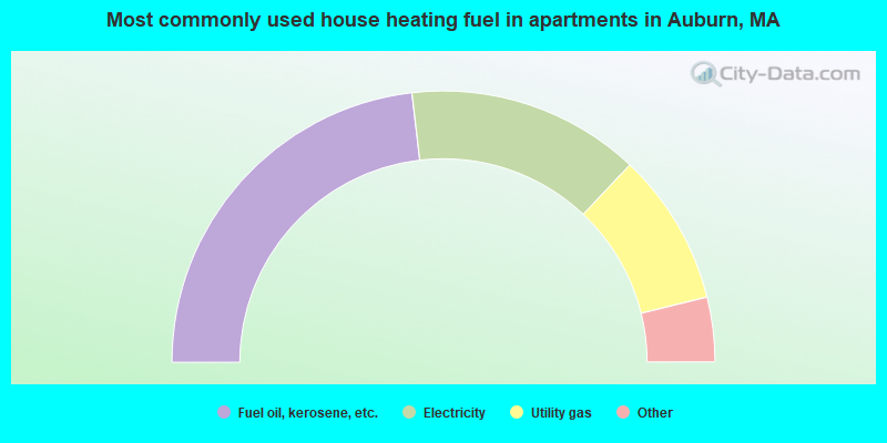
- 46.3%Fuel oil, kerosene, etc.
- 27.8%Electricity
- 18.2%Utility gas
- 3.0%Bottled, tank, or LP gas
- 2.9%No fuel used
- 1.7%Other fuel
Auburn compared to Massachusetts state average:
- Unemployed percentage significantly below state average.
- Black race population percentage significantly below state average.
- Hispanic race population percentage significantly below state average.
- Median age above state average.
- Foreign-born population percentage significantly below state average.
- Renting percentage below state average.
- Length of stay since moving in significantly above state average.
- Number of rooms per house significantly below state average.
- House age significantly below state average.
Auburn on our top lists:
- #31 on the list of "Top 101 cities with largest percentage of males in occupations: material recording, scheduling, dispatching, and distributing workers (population 5,000+)"
- #34 on the list of "Top 101 cities with largest percentage of males in industries: u. s. postal service (population 5,000+)"
- #57 on the list of "Top 101 cities with largest percentage of males in industries: nonmetallic mineral products (population 5,000+)"
- #65 on the list of "Top 101 cities with largest percentage of males in occupations: preschool, kindergarten, elementary and middle school teachers (population 5,000+)"
- #78 on the list of "Top 101 cities with largest percentage of males in occupations: customer service representatives (population 5,000+)"
- #79 on the list of "Top 101 cities with largest percentage of males in occupations: therapists (population 5,000+)"
- #80 on the list of "Top 101 cities with largest percentage of males in industries: miscellaneous nondurable goods merchant wholesalers (population 5,000+)"
- #81 on the list of "Top 101 cities with largest percentage of males in industries: miscellaneous manufacturing (population 5,000+)"
- #83 on the list of "Top 101 cities with largest percentage of males in occupations: secondary school teachers (population 5,000+)"
- #84 on the list of "Top 101 cities with largest percentage of males in industries: paper and paper products merchant wholesalers (population 5,000+)"
- #97 on the list of "Top 101 cities with largest percentage of males in occupations: mathematical science occupations (population 5,000+)"
- #4 on the list of "Top 101 counties with the highest carbon monoxide air pollution readings in 2012 (ppm)"
- #5 on the list of "Top 101 counties with the most Catholic congregations"
- #12 on the list of "Top 101 counties with the highest surface withdrawal of fresh water for public supply"
- #16 on the list of "Top 101 counties with the highest total withdrawal of fresh water for public supply"
- #23 on the list of "Top 101 counties with the highest Sulfur Oxides Annual air pollution readings in 2012 (µg/m3)"

|
|
Total of 139 patent applications in 2008-2024.