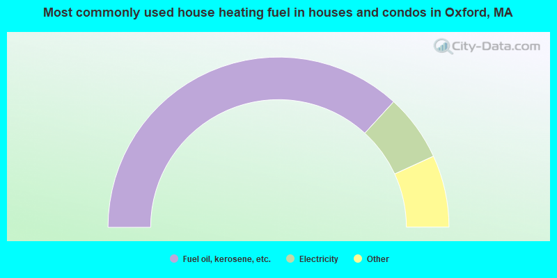
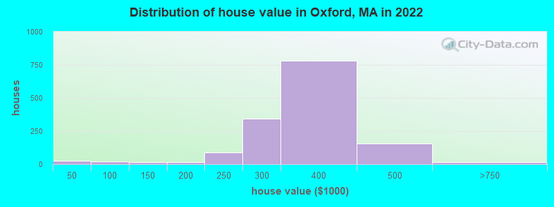
Estimated median house or condo value in 2022: $339,913 (it was $118,100 in 2000)
Oxford:
$339,913
MA:
$534,700
Mean prices in 2022:all housing units: $419,164; detached houses: $447,621; townhouses or other attached units: $343,592; in 2-unit structures: $323,295; in 3-to-4-unit structures: $332,295; in 5-or-more-unit structures: $232,758; mobile homes: $113,885
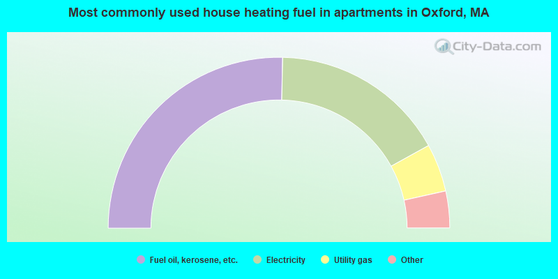
Median gross rent in 2022: $954.
March 2022 cost of living index in Oxford: 126.0 (high, U.S. average is 100)
Percentage of residents living in poverty in 2022: 6.2%
(4.0% for White Non-Hispanic residents, 23.8% for Hispanic or Latino residents, 83.7% for two or more races residents)
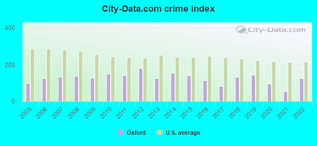
The City-Data.com crime index weighs serious crimes and violent crimes more heavily. Higher means more crime, U.S. average is 246.1. It adjusts for the number of visitors and daily workers commuting into cities.
Latest news from Oxford, MA collected exclusively by city-data.com from local newspapers, TV, and radio stations
Ancestries: Irish (30.3%), American (20.4%), French (7.3%), Polish (6.3%), Brazilian (4.7%), Italian (4.6%).
Current Local Time: EST time zone
Incorporated in 1713
Land area: 3.50 square miles.
Population density: 1,742 people per square mile (low).
325 residents are foreign born (3.1% Latin America, 2.1% Europe, 0.7% Asia).
This place:
6.0%
Massachusetts:
17.6%
Median real estate property taxes paid for housing units with mortgages in 2022: $3,966 (1.2%) Median real estate property taxes paid for housing units with no mortgage in 2022: $3,714 (1.1%)
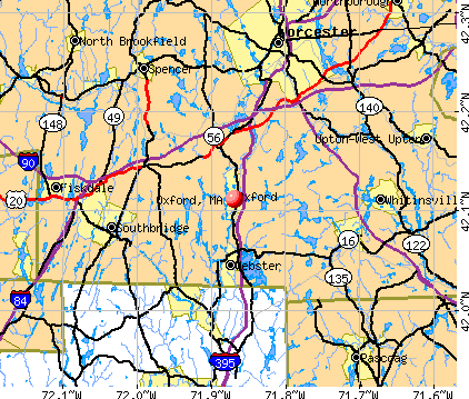
Nearest city with pop. 50,000+: Worcester, MA (11.4 miles , pop. 172,648).
Nearest city with pop. 200,000+: Boston, MA (42.5 miles , pop. 589,141).
Nearest city with pop. 1,000,000+: Bronx, NY (135.8 miles , pop. 1,332,650).
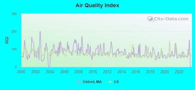
Air Quality Index (AQI) level in 2023 was 83.5. This is about average.
City:
83.5
U.S.:
72.6
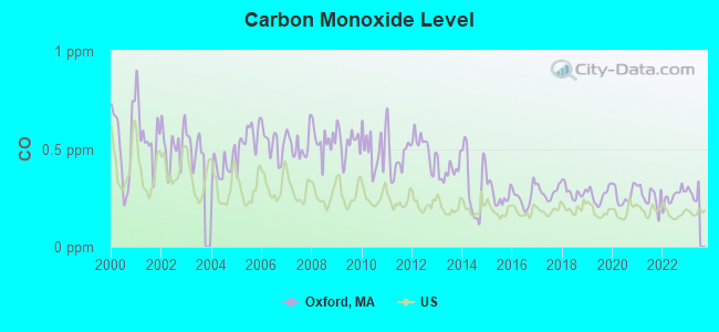
Carbon Monoxide (CO) [ppm] level in 2022 was 0.259. This is about average.Closest monitor was 10.8 miles away from the city center.
City:
0.259
U.S.:
0.251
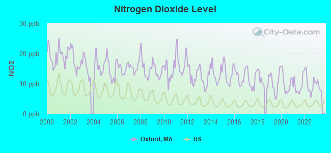
Nitrogen Dioxide (NO2) [ppb] level in 2022 was 10.1. This is significantly worse than average.Closest monitor was 9.8 miles away from the city center.
City:
10.1
U.S.:
5.1
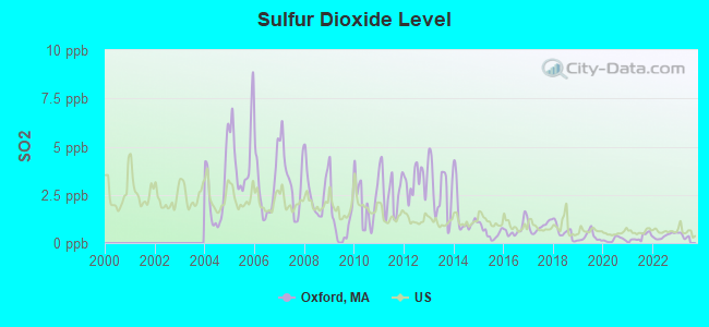
Sulfur Dioxide (SO2) [ppb] level in 2022 was 0.370. This is significantly better than average.Closest monitor was 9.8 miles away from the city center.
City:
0.370
U.S.:
1.515
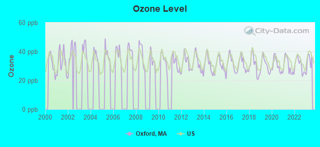
Ozone [ppb] level in 2023 was 33.0. This is about average.Closest monitor was 10.8 miles away from the city center.
City:
33.0
U.S.:
33.3
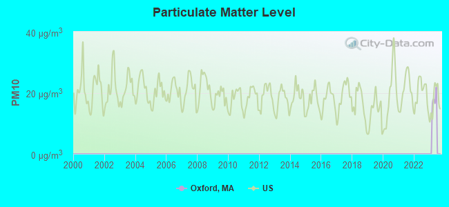
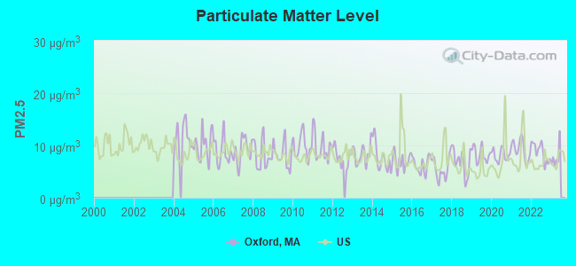
Particulate Matter (PM2.5) [µg/m3] level in 2022 was 8.71. This is about average.Closest monitor was 10.9 miles away from the city center.
City:
8.71
U.S.:
8.11
Tornado activity:
Oxford-area historical tornado activity is slightly above Massachusetts state average. It is 22% smaller than the overall U.S. average.
On 6/9/1953, a category F4 (max. wind speeds 207-260 mph) tornado 22.1 miles away from the Oxford place center killed 90 peopleand injured 1228 peopleand causedbetween $50,000,000 and $500,000,000 in damages.
On 6/9/1953, a category F3 (max. wind speeds 158-206 mph) tornado 6.5 miles away from the place center injured 17 peopleand causedbetween $500,000 and $5,000,000 in damages.
Earthquake activity:
Oxford-area historical earthquake activity is significantly above Massachusetts state average. It is 72% smaller than the overall U.S. average.
On 10/7/1983 at 10:18:46, a magnitude 5.3 (5.1 MB, 5.3 LG, 5.1 ML, Class: Moderate, Intensity: VI - VII) earthquake occurred 178.5 miles away from Oxford center On 4/20/2002 at 10:50:47, a magnitude 5.3 (5.3 ML, Depth: 3.0 mi) earthquake occurred 189.8 miles away from the city center On 4/20/2002 at 10:50:47, a magnitude 5.2 (5.2 MB, 4.2 MS, 5.2 MW, 5.0 MW) earthquake occurred 188.8 miles away from Oxford center On 1/19/1982 at 00:14:42, a magnitude 4.7 (4.5 MB, 4.7 MD, 4.5 LG, Class: Light, Intensity: IV - V) earthquake occurred 97.0 miles away from Oxford center On 10/16/2012 at 23:12:25, a magnitude 4.7 (4.7 ML, Depth: 10.0 mi) earthquake occurred 119.7 miles away from the city center On 8/22/1992 at 12:20:32, a magnitude 4.8 (4.8 MB, 3.8 MS, 4.7 LG, Depth: 6.2 mi) earthquake occurred 223.3 miles away from Oxford center Magnitude types: regional Lg-wave magnitude (LG), body-wave magnitude (MB), duration magnitude (MD), local magnitude (ML), surface-wave magnitude (MS), moment magnitude (MW)
Natural disasters:
The number of natural disasters in Worcester County (27) is a lot greater than the US average (15). Major Disasters (Presidential) Declared: 15 Emergencies Declared: 12
Causes of natural disasters: Floods: 9, Storms: 8, Hurricanes: 6, Snowstorms: 5, Winter Storms: 4, Blizzards: 2, Snows: 2, Fire: 1, Heavy Rain: 1, Snowfall: 1, Tornado: 1, Wind: 1 (Note: some incidents may be assigned to more than one category).
Hospitals and medical centers in Oxford:
SANDALWOOD CARE AND REHABILITATION CENTER (3 PINE STREET)
Other hospitals and medical centers near Oxford:
OAKWOOD REHABILITATION AND NURSING CENTER (Nursing Home, about 4 miles away; WEBSTER, MA)
LIFE CARE CENTER OF AUBURN (Nursing Home, about 5 miles away; AUBURN, MA)
VNA OF SOUTHERN WORC CNTY (Home Health Center, about 5 miles away; WEBSTER, MA)
WEBSTER MANOR LONG TERM CARE FACILITY (Nursing Home, about 6 miles away; WEBSTER, MA)
WEBSTER HOUSE LTC FACILITY (Nursing Home, about 6 miles away; WEBSTER, MA)
LANESSA EXTENDED CARE FACILITY (Nursing Home, about 6 miles away; WEBSTER, MA)
SOUTH COUNTY DIALYSIS CENTER (Dialysis Facility, about 6 miles away; WEBSTER, MA)
Amtrak station near Oxford:
12 miles: WORCESTER (WORCHESTER, 45 SHREWSBURY ST.) . Services: ticket office, fully wheelchair accessible, enclosed waiting area, public restrooms, public payphones, vending machines, free short-term parking, free long-term parking, call for taxi service, public transit connection.
Colleges/universities with over 2000 students nearest to Oxford:
College of the Holy Cross (about 10 miles; Worcester, MA; Full-time enrollment: 3,125)
Clark University (about 10 miles; Worcester, MA; FT enrollment: 3,687)
Worcester State University (about 11 miles; Worcester, MA; FT enrollment: 5,426)
Worcester Polytechnic Institute (about 12 miles; Worcester, MA; FT enrollment: 3,930)
Assumption College (about 13 miles; Worcester, MA; FT enrollment: 2,580)
Quinsigamond Community College (about 15 miles; Worcester, MA; FT enrollment: 5,877)
Bryant University (about 22 miles; Smithfield, RI; FT enrollment: 3,440)
Public high schools in Oxford:
OXFORD HIGH(Students: 629, Location: 495 MAIN STREET, Grades: 9-12)
PROJECT C.O.F.F.E.E. (Location: 495 1/2 MAIN STREET, Grades: 5-12)
Public elementary/middle schools in Oxford:
OXFORD MIDDLE(Students: 688, Location: 497 MAIN STREET, Grades: 5-8)
ALFRED M CHAFFEE(Students: 475, Location: 9 CLOVER STREET, Grades: KG-2)
CLARA BARTON(Students: 372, Location: 25 DEPOT ROAD, Grades: PK-4)
Private elementary/middle school in Oxford:
OAK HILL CHRISTIAN SCHOOL (Students: 33, Location: 40 SACARRAPPA RD, Grades: PK-7)
Notable locations in Oxford: Oxford Fire Department Station 1 Headquarters (A), Oxford Town Hall (B), Oxford Free Library (C). Display/hide their locations on the map
Lakes, reservoirs, and swamps: Carbuncle Pond (A), Hodges Village Pond (B), McKinstry Pond (C), Lowes Pond (D), Cedar Swamp (E). Display/hide their locations on the map
Birthplace of: Clara Barton - (1821-1912), nurse, Elliott P. Joslin - Physician, Richard Olney - Politician, Tom Herrion - Basketball player-coach, Nelson H. Davis - Brigadier general in the Army during the Civil War.
Worcester County has a predicted average indoor radon screening level greater than 4 pCi/L (pico curies per liter) - Highest Potential
Drinking water stations with addresses in Oxford and their reported violations in the past:
MCL, Monthly (TCR) - In JUL-2009, Contaminant: Coliform. Follow-up actions: St AO (w/o penalty) issued (SEP-22-2009), St Compliance achieved (SEP-22-2009)
CHARLTON STREET APARTMENTS (Population served: 33, Groundwater):
Past monitoring violations:
8 routine major monitoring violations
26 regular monitoring violations
Average household size:
This place:
2.6 people
Massachusetts:
2.5 people
Percentage of family households:
This place:
67.7%
Whole state:
63.0%
Percentage of households with unmarried partners:
This place:
6.6%
Whole state:
7.0%
Likely homosexual households (counted as self-reported same-sex unmarried-partner households)
Lesbian couples: 0.3% of all households
Gay men: 0.5% of all households
68 people in nursing facilities/skilled-nursing facilities in 2010
69 people in nursing homes in 2000
3 people in religious group quarters in 2000
Banks with branches in Oxford (2011 data):
Sovereign Bank, National Association: Oxford Branch at 335 Main Street, branch established on 1955/11/07. Info updated 2012/01/31: Bank assets: $78,146.9 mil, Deposits: $48,042.9 mil, headquarters in Wilmington, DE, positive income, Commercial Lending Specialization, 718 total offices, Holding Company: Banco Santander, S.A.
Webster Five Cents Savings Bank: Oxford Branch at 343 Main Street, branch established on 1961/11/29. Info updated 2009/05/20: Bank assets: $558.9 mil, Deposits: $465.4 mil, headquarters in Webster, MA, positive income, Commercial Lending Specialization, 8 total offices, Holding Company: Webfive Mhc
Hometown Bank, A Cooperative Bank: Oxford Branch at 31 Sutton Avenue, branch established on 2000/06/19. Info updated 2011/04/11: Bank assets: $301.7 mil, Deposits: $250.6 mil, headquarters in Webster, MA, positive income, Commercial Lending Specialization, 5 total offices
Bank of America, National Association: Oxford Branch at 324 Main Street, branch established on 1981/04/22. Info updated 2009/11/18: Bank assets: $1,451,969.3 mil, Deposits: $1,077,176.8 mil, headquarters in Charlotte, NC, positive income, 5782 total offices, Holding Company: Bank Of America Corporation
Religion statistics for Oxford, MA (based on Worcester County data)
Religion
Adherents
Congregations
Catholic
306,925
118
Mainline Protestant
43,326
171
Evangelical Protestant
37,511
203
Other
18,931
69
Orthodox
7,935
15
Black Protestant
497
6
None
383,427
-
Source: Clifford Grammich, Kirk Hadaway, Richard Houseal, Dale E.Jones, Alexei Krindatch, Richie Stanley and Richard H.Taylor. 2012. 2010 U.S.Religion Census: Religious Congregations & Membership Study. Association of Statisticians of American Religious Bodies. Jones, Dale E., et al. 2002. Congregations and Membership in the United States 2000. Nashville, TN: Glenmary Research Center. Graphs represent county-level data
Aircraft: MOONEY M20J (Category: Land, Seats: 4, Weight: Up to 12,499 Pounds, Speed: 126 mph), Engine: LYCOMING I0360 SER (180 HP) (Reciprocating) N-Number: 201CY, N201CY, N-201CY, Serial Number: 24-0444, Year manufactured: 1978, Airworthiness Date: 02/02/1978, Certificate Issue Date: 05/23/1987 Registrant (Co-Owned): James B Triplett, 25 Camphill Drive, Oxford, MA 01540, Other Owners: Triplett Jacklyn A Flemming
Aircraft: ENSTROM F-28F (Category: Land, Seats: 3, Weight: Up to 12,499 Pounds), Engine: LYCOMING HIO-360 SER (205 HP) (Reciprocating) N-Number: 8630Y, N8630Y, N-8630Y, Serial Number: 740, Year manufactured: 1985, Airworthiness Date: 08/21/1985, Certificate Issue Date: 03/24/1994 Registrant (Corporation): M And M Aviation Inc, 31 Town Forest Rd, Oxford, MA 01540
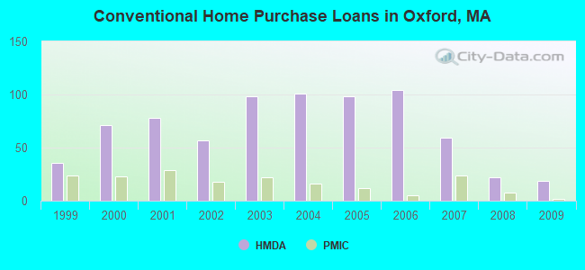
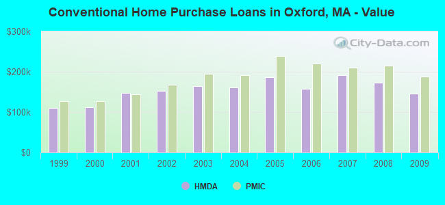
Home Mortgage Disclosure Act Aggregated Statistics For Year 2009 (Based on 1 partial tract)
A) FHA, FSA/RHS & VA Home Purchase Loans
B) Conventional Home Purchase Loans
C) Refinancings
D) Home Improvement Loans
E) Loans on Dwellings For 5+ Families
F) Non-occupant Loans on < 5 Family Dwellings (A B C & D)
Number
Average Value
Number
Average Value
Number
Average Value
Number
Average Value
Number
Average Value
Number
Average Value
LOANS ORIGINATED
28
$180,319
19
$145,832
112
$180,442
14
$86,991
2
$133,500
5
$101,462
APPLICATIONS APPROVED, NOT ACCEPTED
2
$167,955
2
$94,310
11
$176,880
2
$15,075
0
$0
0
$0
APPLICATIONS DENIED
3
$175,707
5
$158,996
31
$191,986
3
$126,610
1
$947,430
1
$99,910
APPLICATIONS WITHDRAWN
3
$192,357
3
$140,393
29
$184,942
2
$92,590
0
$0
0
$0
FILES CLOSED FOR INCOMPLETENESS
1
$214,460
3
$143,837
8
$202,836
1
$14,640
0
$0
0
$0
Aggregated Statistics For Year 2008 (Based on 1 partial tract)
A) FHA, FSA/RHS & VA Home Purchase Loans
B) Conventional Home Purchase Loans
C) Refinancings
D) Home Improvement Loans
E) Loans on Dwellings For 5+ Families
F) Non-occupant Loans on < 5 Family Dwellings (A B C & D)
Number
Average Value
Number
Average Value
Number
Average Value
Number
Average Value
Number
Average Value
Number
Average Value
LOANS ORIGINATED
20
$187,634
22
$173,278
64
$189,849
22
$55,906
1
$344,520
5
$170,882
APPLICATIONS APPROVED, NOT ACCEPTED
1
$136,090
1
$208,430
9
$174,844
5
$44,098
0
$0
0
$0
APPLICATIONS DENIED
3
$93,307
6
$175,418
47
$221,776
10
$83,718
0
$0
6
$163,933
APPLICATIONS WITHDRAWN
4
$176,135
3
$177,427
15
$219,402
3
$61,727
0
$0
1
$172,260
FILES CLOSED FOR INCOMPLETENESS
1
$173,980
2
$124,890
3
$184,893
1
$45,650
0
$0
2
$124,890
Aggregated Statistics For Year 2007 (Based on 1 partial tract)
A) FHA, FSA/RHS & VA Home Purchase Loans
B) Conventional Home Purchase Loans
C) Refinancings
D) Home Improvement Loans
E) Loans on Dwellings For 5+ Families
F) Non-occupant Loans on < 5 Family Dwellings (A B C & D)
Number
Average Value
Number
Average Value
Number
Average Value
Number
Average Value
Number
Average Value
Number
Average Value
LOANS ORIGINATED
3
$196,090
59
$191,252
134
$165,672
34
$65,459
1
$387,580
9
$169,389
APPLICATIONS APPROVED, NOT ACCEPTED
0
$0
12
$169,963
15
$196,261
1
$74,930
0
$0
1
$142,980
APPLICATIONS DENIED
3
$214,463
18
$167,092
91
$196,471
23
$50,517
0
$0
9
$163,169
APPLICATIONS WITHDRAWN
1
$248,920
8
$175,490
43
$187,683
5
$52,368
0
$0
3
$211,020
FILES CLOSED FOR INCOMPLETENESS
0
$0
5
$121,098
12
$234,632
1
$43,060
0
$0
0
$0
Aggregated Statistics For Year 2006 (Based on 1 partial tract)
A) FHA, FSA/RHS & VA Home Purchase Loans
B) Conventional Home Purchase Loans
C) Refinancings
D) Home Improvement Loans
E) Loans on Dwellings For 5+ Families
F) Non-occupant Loans on < 5 Family Dwellings (A B C & D)
G) Loans On Manufactured Home Dwelling (A B C & D)
Number
Average Value
Number
Average Value
Number
Average Value
Number
Average Value
Number
Average Value
Number
Average Value
Number
Average Value
LOANS ORIGINATED
3
$186,903
104
$157,817
194
$162,910
47
$79,991
1
$269,590
9
$120,869
1
$40,480
APPLICATIONS APPROVED, NOT ACCEPTED
0
$0
10
$125,405
25
$175,223
4
$43,710
0
$0
1
$158,480
0
$0
APPLICATIONS DENIED
0
$0
21
$161,924
121
$190,055
28
$153,680
0
$0
3
$150,727
0
$0
APPLICATIONS WITHDRAWN
0
$0
14
$110,246
72
$174,425
8
$83,761
0
$0
2
$64,595
1
$25,840
FILES CLOSED FOR INCOMPLETENESS
0
$0
1
$268,730
21
$249,285
0
$0
0
$0
1
$219,630
0
$0
Aggregated Statistics For Year 2005 (Based on 1 partial tract)
A) FHA, FSA/RHS & VA Home Purchase Loans
B) Conventional Home Purchase Loans
C) Refinancings
D) Home Improvement Loans
F) Non-occupant Loans on < 5 Family Dwellings (A B C & D)
Number
Average Value
Number
Average Value
Number
Average Value
Number
Average Value
Number
Average Value
LOANS ORIGINATED
3
$262,697
98
$186,278
222
$171,503
42
$61,501
9
$199,056
APPLICATIONS APPROVED, NOT ACCEPTED
1
$181,730
13
$187,631
36
$161,135
9
$50,147
2
$108,955
APPLICATIONS DENIED
0
$0
14
$167,584
113
$177,413
18
$80,005
2
$82,255
APPLICATIONS WITHDRAWN
1
$213,600
20
$188,151
115
$168,291
9
$275,712
3
$176,567
FILES CLOSED FOR INCOMPLETENESS
0
$0
2
$165,370
41
$190,704
0
$0
1
$93,880
Aggregated Statistics For Year 2004 (Based on 1 partial tract)
A) FHA, FSA/RHS & VA Home Purchase Loans
B) Conventional Home Purchase Loans
C) Refinancings
D) Home Improvement Loans
F) Non-occupant Loans on < 5 Family Dwellings (A B C & D)
G) Loans On Manufactured Home Dwelling (A B C & D)
Number
Average Value
Number
Average Value
Number
Average Value
Number
Average Value
Number
Average Value
Number
Average Value
LOANS ORIGINATED
5
$195,860
101
$161,038
250
$161,022
40
$89,274
13
$126,346
1
$89,580
APPLICATIONS APPROVED, NOT ACCEPTED
1
$88,710
10
$205,334
22
$141,958
7
$92,651
2
$90,435
1
$13,780
APPLICATIONS DENIED
0
$0
10
$192,156
76
$160,213
22
$48,390
3
$188,913
0
$0
APPLICATIONS WITHDRAWN
0
$0
11
$166,701
77
$158,915
6
$83,403
5
$172,088
0
$0
FILES CLOSED FOR INCOMPLETENESS
1
$254,080
4
$192,715
50
$162,648
3
$84,120
2
$88,285
0
$0
Aggregated Statistics For Year 2003 (Based on 1 partial tract)
A) FHA, FSA/RHS & VA Home Purchase Loans
B) Conventional Home Purchase Loans
C) Refinancings
D) Home Improvement Loans
E) Loans on Dwellings For 5+ Families
F) Non-occupant Loans on < 5 Family Dwellings (A B C & D)
Number
Average Value
Number
Average Value
Number
Average Value
Number
Average Value
Number
Average Value
Number
Average Value
LOANS ORIGINATED
13
$203,135
98
$164,447
470
$135,285
19
$24,162
3
$242,887
12
$154,460
APPLICATIONS APPROVED, NOT ACCEPTED
0
$0
9
$177,428
64
$130,850
3
$69,477
0
$0
1
$81,820
APPLICATIONS DENIED
0
$0
12
$159,915
125
$144,306
13
$24,315
0
$0
0
$0
APPLICATIONS WITHDRAWN
0
$0
8
$155,465
100
$138,721
3
$27,850
0
$0
2
$92,590
FILES CLOSED FOR INCOMPLETENESS
0
$0
0
$0
10
$172,002
0
$0
0
$0
0
$0
Aggregated Statistics For Year 2002 (Based on 1 partial tract)
A) FHA, FSA/RHS & VA Home Purchase Loans
B) Conventional Home Purchase Loans
C) Refinancings
D) Home Improvement Loans
E) Loans on Dwellings For 5+ Families
F) Non-occupant Loans on < 5 Family Dwellings (A B C & D)
Number
Average Value
Number
Average Value
Number
Average Value
Number
Average Value
Number
Average Value
Number
Average Value
LOANS ORIGINATED
16
$174,575
57
$151,861
316
$126,606
25
$39,964
1
$193,790
11
$108,759
APPLICATIONS APPROVED, NOT ACCEPTED
3
$192,070
9
$150,440
54
$111,427
11
$39,228
0
$0
4
$119,505
APPLICATIONS DENIED
2
$119,290
10
$135,396
73
$124,641
13
$39,222
0
$0
3
$38,470
APPLICATIONS WITHDRAWN
2
$141,685
6
$153,885
69
$125,425
8
$47,695
0
$0
1
$74,070
FILES CLOSED FOR INCOMPLETENESS
0
$0
3
$100,197
9
$159,819
0
$0
0
$0
0
$0
Aggregated Statistics For Year 2001 (Based on 1 partial tract)
A) FHA, FSA/RHS & VA Home Purchase Loans
B) Conventional Home Purchase Loans
C) Refinancings
D) Home Improvement Loans
E) Loans on Dwellings For 5+ Families
F) Non-occupant Loans on < 5 Family Dwellings (A B C & D)
Number
Average Value
Number
Average Value
Number
Average Value
Number
Average Value
Number
Average Value
Number
Average Value
LOANS ORIGINATED
13
$143,705
78
$147,360
266
$107,980
27
$21,501
1
$126,610
7
$52,293
APPLICATIONS APPROVED, NOT ACCEPTED
2
$127,470
7
$170,169
34
$104,141
9
$21,341
0
$0
0
$0
APPLICATIONS DENIED
0
$0
9
$106,706
76
$86,629
9
$32,347
0
$0
2
$77,515
APPLICATIONS WITHDRAWN
1
$62,870
3
$178,003
78
$110,920
6
$34,452
0
$0
1
$86,130
FILES CLOSED FOR INCOMPLETENESS
0
$0
1
$108,520
5
$114,208
0
$0
0
$0
0
$0
Aggregated Statistics For Year 2000 (Based on 1 partial tract)
A) FHA, FSA/RHS & VA Home Purchase Loans
B) Conventional Home Purchase Loans
C) Refinancings
D) Home Improvement Loans
F) Non-occupant Loans on < 5 Family Dwellings (A B C & D)
Number
Average Value
Number
Average Value
Number
Average Value
Number
Average Value
Number
Average Value
LOANS ORIGINATED
16
$145,183
71
$112,478
60
$82,139
23
$23,442
3
$85,843
APPLICATIONS APPROVED, NOT ACCEPTED
2
$96,465
10
$108,265
13
$98,652
3
$31,867
0
$0
APPLICATIONS DENIED
3
$177,713
11
$106,723
49
$73,457
14
$23,747
0
$0
APPLICATIONS WITHDRAWN
3
$90,723
8
$93,774
36
$81,321
3
$45,073
1
$34,450
FILES CLOSED FOR INCOMPLETENESS
0
$0
1
$48,230
5
$113,520
0
$0
1
$48,230
Aggregated Statistics For Year 1999 (Based on 1 partial tract)
A) FHA, FSA/RHS & VA Home Purchase Loans
B) Conventional Home Purchase Loans
C) Refinancings
D) Home Improvement Loans
E) Loans on Dwellings For 5+ Families
F) Non-occupant Loans on < 5 Family Dwellings (A B C & D)
Detailed PMIC statistics for the following Tracts:7532.00
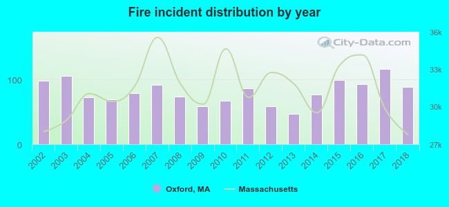
2002 - 2018 National Fire Incident Reporting System (NFIRS) incidents
Based on the data from the years 2002 - 2018 the average number of fire incidents per year is 81. The highest number of fire incidents - 116 took place in 2017, and the least - 47 in 2013. The data has a decreasing trend.
When looking into fire subcategories, the most reports belonged to: Structure Fires (46.3%), and Outside Fires (34.1%).
Fire incident types reported to NFIRS in Oxford, MA


 Recent articles from our blog. Our writers, many of them Ph.D. graduates or candidates, create easy-to-read articles on a wide variety of topics.

 (11.4 miles


 Based on the data from the years 2002 - 2018 the average number of fire incidents per year is 81. The highest number of fire incidents - 116 took place in 2017, and the least - 47 in 2013. The data has a decreasing trend.
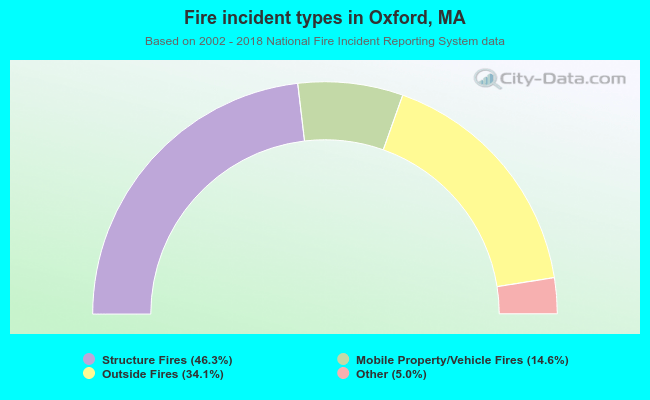 When looking into fire subcategories, the most reports belonged to: Structure Fires (46.3%), and Outside Fires (34.1%).