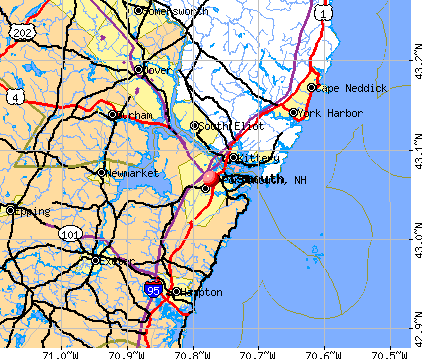
Portsmouth, New Hampshire

Portsmouth: Portsmouth's Garden Fever
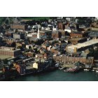
Portsmouth
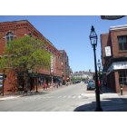
Portsmouth: Portsmouth city scene
Portsmouth

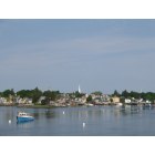
Portsmouth: Sunset over Portsmouth Harbor
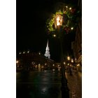
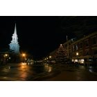
Portsmouth: North Church

Portsmouth
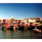
Portsmouth: Tugboats at dock Portsmouth NH

Portsmouth: Memorial Bridge Slack tide reflection over Piscataqua River Portsmouth NH
Portsmouth: Market Square and North Church
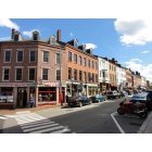
Portsmouth: Market Street
- see
23
more - add
your
Submit your own pictures of this city and show them to the world
- OSM Map
- General Map
- Google Map
- MSN Map
Population change since 2000: +9.3%
 |
| Males: 10,975 | |
| Females: 11,738 |
| Median resident age: | 42.3 years |
| New Hampshire median age: | 43.3 years |
Zip codes: 03801.
| Portsmouth: | $97,640 |
| NH: | $89,992 |
Estimated per capita income in 2022: $70,568 (it was $27,540 in 2000)
Portsmouth city income, earnings, and wages data
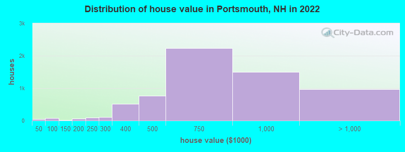
Estimated median house or condo value in 2022: $677,477 (it was $164,500 in 2000)
| Portsmouth: | $677,477 |
| NH: | $384,700 |
Mean prices in 2022: all housing units: $867,904; detached houses: $926,567; townhouses or other attached units: $630,990; in 2-unit structures: $828,957; in 3-to-4-unit structures: over $1,000,000; in 5-or-more-unit structures: $846,892; mobile homes: $176,112
Median gross rent in 2022: $1,717.
(5.6% for White Non-Hispanic residents, 6.0% for Black residents, 11.3% for Hispanic or Latino residents, 8.2% for other race residents, 2.1% for two or more races residents)
Detailed information about poverty and poor residents in Portsmouth, NH


- 19,41786.5%White alone
- 9524.2%Asian alone
- 7983.6%Two or more races
- 5982.7%Hispanic
- 5222.3%Other race alone
- 2371.1%Black alone
- 200.09%American Indian alone
- 80.04%Native Hawaiian and Other
Pacific Islander alone
Races in Portsmouth detailed stats: ancestries, foreign born residents, place of birth
According to our research of New Hampshire and other state lists, there were 14 registered sex offenders living in Portsmouth, New Hampshire as of April 28, 2024.
The ratio of all residents to sex offenders in Portsmouth is 1,541 to 1.
The ratio of registered sex offenders to all residents in this city is much lower than the state average.
Type |
2009 |
2010 |
2011 |
2012 |
2013 |
2014 |
2015 |
2016 |
2017 |
2018 |
2019 |
2020 |
2021 |
2022 |
|---|---|---|---|---|---|---|---|---|---|---|---|---|---|---|
| Murders (per 100,000) | 0 (0.0) | 1 (4.8) | 0 (0.0) | 0 (0.0) | 1 (4.7) | 0 (0.0) | 0 (0.0) | 0 (0.0) | 0 (0.0) | 0 (0.0) | 0 (0.0) | 0 (0.0) | 0 (0.0) | 0 (0.0) |
| Rapes (per 100,000) | 4 (19.6) | 4 (19.3) | 6 (28.2) | 5 (23.9) | 14 (65.3) | 15 (69.7) | 12 (55.3) | 17 (78.7) | 10 (46.3) | 10 (45.4) | 10 (45.6) | 10 (45.4) | 27 (123.2) | 10 (44.4) |
| Robberies (per 100,000) | 12 (58.8) | 6 (28.9) | 9 (42.3) | 11 (52.7) | 15 (69.9) | 4 (18.6) | 8 (36.8) | 5 (23.1) | 6 (27.8) | 3 (13.6) | 2 (9.1) | 1 (4.5) | 1 (4.6) | 2 (8.9) |
| Assaults (per 100,000) | 23 (112.7) | 16 (77.0) | 37 (174.0) | 18 (86.2) | 21 (97.9) | 18 (83.6) | 17 (78.3) | 16 (74.0) | 24 (111.1) | 22 (99.8) | 16 (72.9) | 16 (72.6) | 26 (118.7) | 28 (124.4) |
| Burglaries (per 100,000) | 79 (387.2) | 68 (327.3) | 83 (390.4) | 61 (292.0) | 50 (233.1) | 43 (199.8) | 36 (165.8) | 28 (129.6) | 27 (125.0) | 23 (104.4) | 28 (127.6) | 17 (77.2) | 11 (50.2) | 12 (53.3) |
| Thefts (per 100,000) | 552 (2,706) | 524 (2,522) | 513 (2,413) | 515 (2,466) | 503 (2,345) | 448 (2,082) | 350 (1,612) | 314 (1,453) | 256 (1,185) | 306 (1,389) | 309 (1,408) | 216 (980.4) | 296 (1,351) | 252 (1,119) |
| Auto thefts (per 100,000) | 17 (83.3) | 24 (115.5) | 16 (75.3) | 16 (76.6) | 20 (93.2) | 16 (74.3) | 19 (87.5) | 26 (120.3) | 17 (78.7) | 17 (77.1) | 22 (100.2) | 16 (72.6) | 17 (77.6) | 18 (80.0) |
| Arson (per 100,000) | 1 (4.9) | 6 (28.9) | 4 (18.8) | 1 (4.8) | 3 (14.0) | 2 (9.3) | 2 (9.2) | 6 (27.8) | 3 (13.9) | 3 (13.6) | 1 (4.6) | 2 (9.1) | 1 (4.6) | 2 (8.9) |
| City-Data.com crime index | 197.9 | 182.1 | 199.9 | 177.4 | 219.6 | 181.3 | 154.0 | 161.5 | 130.0 | 129.4 | 127.0 | 102.6 | 187.4 | 118.0 |
The City-Data.com crime index weighs serious crimes and violent crimes more heavily. Higher means more crime, U.S. average is 246.1. It adjusts for the number of visitors and daily workers commuting into cities.
Crime rate in Portsmouth detailed stats: murders, rapes, robberies, assaults, burglaries, thefts, arson
Full-time law enforcement employees in 2021, including police officers: 84 (65 officers - 61 male; 4 female).
| Officers per 1,000 residents here: | 2.97 |
| New Hampshire average: | 2.14 |
 Recent articles from our blog. Our writers, many of them Ph.D. graduates or candidates, create easy-to-read articles on a wide variety of topics.

 | Empty Nesters Moving to Portsmouth area (7 replies) |
| Crime/Gangs in Portsmouth NH? (14 replies) |
| Portsmouth Hotel Recommendations? (1 reply) |
| Best safe towns for commute to Portsmouth NH (34 replies) |
| Drinking water safety in Newmarket/Dover/Portsmouth (13 replies) |
| Neighborhood Help ... Near Portsmouth (6 replies) |
Latest news from Portsmouth, NH collected exclusively by city-data.com from local newspapers, TV, and radio stations
Ancestries: English (17.5%), Irish (16.7%), American (6.8%), Italian (6.0%), German (4.9%), French (4.1%).
Current Local Time: EST time zone
Incorporated in 1631
Elevation: 21 feet
Land area: 15.6 square miles.
Population density: 1,455 people per square mile (low).
1,992 residents are foreign born (4.1% Asia, 3.2% Europe, 0.9% Latin America).
| This city: | 8.9% |
| New Hampshire: | 6.0% |
Median real estate property taxes paid for housing units with mortgages in 2022: $7,885 (1.1%)
Median real estate property taxes paid for housing units with no mortgage in 2022: $7,355 (1.2%)
Nearest city with pop. 50,000+: Haverhill, MA  (25.5 miles , pop. 58,969).
Nearest city with pop. 200,000+: Boston, MA (54.0 miles , pop. 589,141).
Nearest city with pop. 1,000,000+: Bronx, NY (221.4 miles , pop. 1,332,650).
Nearest cities:
), ), )Latitude: 43.07 N, Longitude: 70.77 W
Daytime population change due to commuting: +19,427 (+86.6%)
Workers who live and work in this city: 6,580 (50.6%)
Area code: 603
Portsmouth tourist attractions:
- Market Square is the center of activity, with many galleries, bookstores and restaurants
- Sheraton Harborside Hotel Portsmouth
- Hilton Garden Inn Portsmouth Downtown
- Strawbery Banke Museum, Portsmouth, NH
- USS Albacore Museum, Portsmouth, NH
- Water Country is an adventure park with thrilling rides and attractions
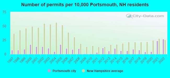
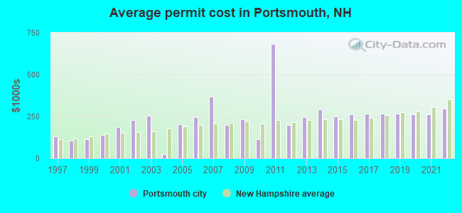
Single-family new house construction building permits:
- 2022: 56 buildings, average cost: $297,400
- 2021: 49 buildings, average cost: $263,500
- 2020: 10 buildings, average cost: $264,300
- 2019: 9 buildings, average cost: $265,200
- 2018: 15 buildings, average cost: $265,900
- 2017: 18 buildings, average cost: $265,000
- 2016: 13 buildings, average cost: $260,700
- 2015: 13 buildings, average cost: $251,100
- 2014: 21 buildings, average cost: $292,900
- 2013: 12 buildings, average cost: $246,600
- 2012: 23 buildings, average cost: $199,900
- 2011: 7 buildings, average cost: $682,000
- 2010: 2 buildings, average cost: $115,000
- 2009: 2 buildings, average cost: $232,200
- 2008: 20 buildings, average cost: $199,200
- 2007: 17 buildings, average cost: $368,500
- 2006: 21 buildings, average cost: $246,300
- 2005: 36 buildings, average cost: $202,600
- 2004: 10 buildings, average cost: $27,200
- 2003: 22 buildings, average cost: $252,900
- 2002: 28 buildings, average cost: $227,300
- 2001: 28 buildings, average cost: $185,500
- 2000: 36 buildings, average cost: $141,100
- 1999: 18 buildings, average cost: $113,300
- 1998: 15 buildings, average cost: $105,900
- 1997: 15 buildings, average cost: $131,400
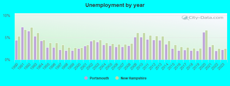
| Here: | 2.3% |
| New Hampshire: | 2.5% |
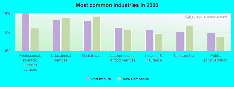
- Professional, scientific, technical services (10.0%)
- Educational services (8.2%)
- Health care (8.1%)
- Accommodation & food services (6.2%)
- Finance & insurance (5.6%)
- Construction (5.1%)
- Public administration (4.7%)
- Professional, scientific, technical services (10.5%)
- Construction (9.1%)
- Finance & insurance (5.9%)
- Public administration (5.9%)
- Accommodation & food services (5.8%)
- Educational services (4.7%)
- Computer & electronic products (4.1%)
- Health care (14.0%)
- Educational services (12.2%)
- Professional, scientific, technical services (9.5%)
- Accommodation & food services (6.7%)
- Finance & insurance (5.3%)
- Social assistance (3.9%)
- Public administration (3.5%)
- Computer specialists (5.3%)
- Other management occupations, except farmers and farm managers (5.1%)
- Other sales and related occupations, including supervisors (5.0%)
- Retail sales workers, except cashiers (3.9%)
- Sales representatives, services, wholesale and manufacturing (3.8%)
- Other office and administrative support workers, including supervisors (3.5%)
- Preschool, kindergarten, elementary, and middle school teachers (3.2%)
- Computer specialists (7.4%)
- Other management occupations, except farmers and farm managers (5.9%)
- Sales representatives, services, wholesale and manufacturing (4.9%)
- Other sales and related occupations, including supervisors (4.8%)
- Material recording, scheduling, dispatching, and distributing workers (3.9%)
- Retail sales workers, except cashiers (3.4%)
- Building and grounds cleaning and maintenance occupations (3.3%)
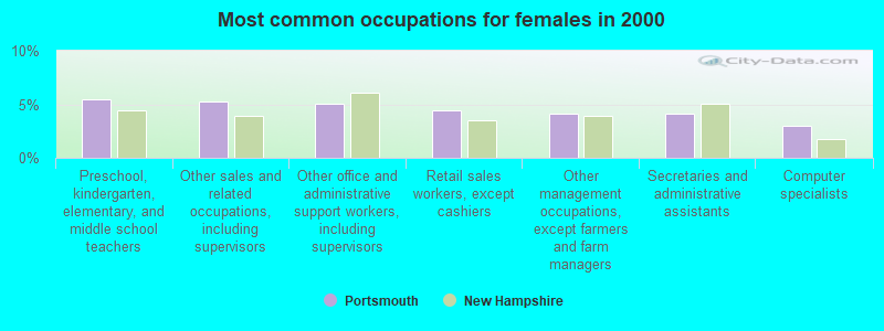
- Preschool, kindergarten, elementary, and middle school teachers (5.4%)
- Other sales and related occupations, including supervisors (5.3%)
- Other office and administrative support workers, including supervisors (5.1%)
- Retail sales workers, except cashiers (4.4%)
- Other management occupations, except farmers and farm managers (4.1%)
- Secretaries and administrative assistants (4.1%)
- Computer specialists (2.9%)
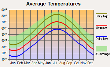
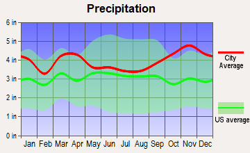
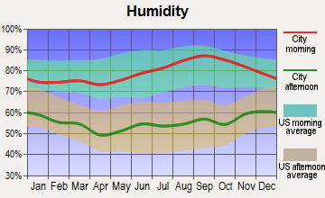
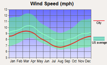
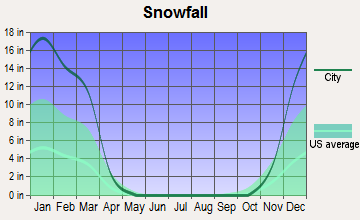
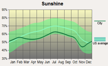
Average climate in Portsmouth, New Hampshire
Based on data reported by over 4,000 weather stations

|
|

(lower is better)
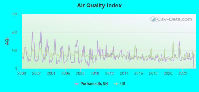
Air Quality Index (AQI) level in 2022 was 61.4. This is about average.
| City: | 61.4 |
| U.S.: | 72.6 |
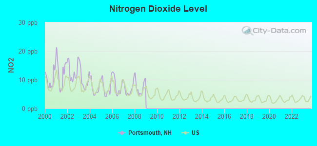
Nitrogen Dioxide (NO2) [ppb] level in 2008 was 7.38. This is significantly worse than average. Closest monitor was 0.1 miles away from the city center.
| City: | 7.38 |
| U.S.: | 5.11 |
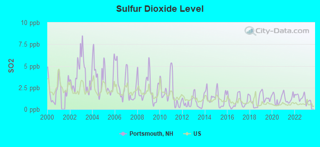
Sulfur Dioxide (SO2) [ppb] level in 2022 was 1.48. This is about average. Closest monitor was 0.1 miles away from the city center.
| City: | 1.48 |
| U.S.: | 1.51 |
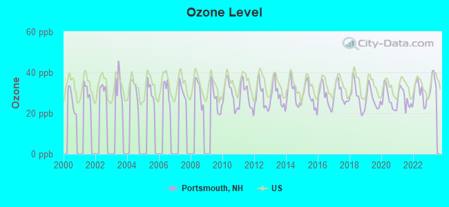
Ozone [ppb] level in 2022 was 29.7. This is about average. Closest monitor was 0.9 miles away from the city center.
| City: | 29.7 |
| U.S.: | 33.3 |
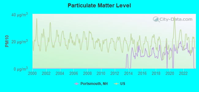
Particulate Matter (PM10) [µg/m3] level in 2022 was 14.4. This is better than average. Closest monitor was 0.9 miles away from the city center.
| City: | 14.4 |
| U.S.: | 19.2 |
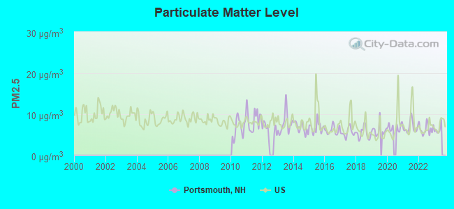
Particulate Matter (PM2.5) [µg/m3] level in 2022 was 6.41. This is better than average. Closest monitor was 0.9 miles away from the city center.
| City: | 6.41 |
| U.S.: | 8.11 |
Tornado activity:
Portsmouth-area historical tornado activity is near New Hampshire state average. It is 58% smaller than the overall U.S. average.
On 6/9/1953, a category F3 (max. wind speeds 158-206 mph) tornado 12.0 miles away from the Portsmouth city center injured 5 people and caused between $5000 and $50,000 in damages.
On 6/19/1957, a category F2 (max. wind speeds 113-157 mph) tornado 2.7 miles away from the city center injured one person and caused between $5000 and $50,000 in damages.
Earthquake activity:
Portsmouth-area historical earthquake activity is significantly above New Hampshire state average. It is 73% smaller than the overall U.S. average.On 10/16/2012 at 23:12:25, a magnitude 4.7 (4.7 ML, Depth: 10.0 mi, Class: Light, Intensity: IV - V) earthquake occurred 37.1 miles away from the city center
On 4/20/2002 at 10:50:47, a magnitude 5.3 (5.3 ML, Depth: 3.0 mi, Class: Moderate, Intensity: VI - VII) earthquake occurred 176.9 miles away from Portsmouth center
On 1/19/1982 at 00:14:42, a magnitude 4.7 (4.5 MB, 4.7 MD, 4.5 LG) earthquake occurred 51.3 miles away from Portsmouth center
On 10/7/1983 at 10:18:46, a magnitude 5.3 (5.1 MB, 5.3 LG, 5.1 ML) earthquake occurred 189.2 miles away from Portsmouth center
On 4/20/2002 at 10:50:47, a magnitude 5.2 (5.2 MB, 4.2 MS, 5.2 MW, 5.0 MW) earthquake occurred 176.8 miles away from Portsmouth center
On 8/21/1996 at 07:54:14, a magnitude 3.8 (3.8 LG, 3.6 LG, Depth: 6.2 mi, Class: Light, Intensity: II - III) earthquake occurred 82.5 miles away from Portsmouth center
Magnitude types: regional Lg-wave magnitude (LG), body-wave magnitude (MB), duration magnitude (MD), local magnitude (ML), surface-wave magnitude (MS), moment magnitude (MW)
Natural disasters:
The number of natural disasters in Rockingham County (26) is a lot greater than the US average (15).Major Disasters (Presidential) Declared: 17
Emergencies Declared: 9
Causes of natural disasters: Storms: 12, Floods: 9, Winter Storms: 5, Hurricanes: 4, Snowstorms: 4, Snows: 2, Winds: 2, Blizzard: 1, Snowfall: 1, Tornado: 1 (Note: some incidents may be assigned to more than one category).
Main business address for: Mueller Group, Inc. (MISCELLANEOUS FABRICATED METAL PRODUCTS), Mueller Water Products, Inc. (MISCELLANEOUS FABRICATED METAL PRODUCTS), ENVIRONMENTAL POWER CORP (COGENERATION SERVICES & SMALL POWER PRODUCERS), BOTTOMLINE TECHNOLOGIES INC /DE/ (SERVICES-PREPACKAGED SOFTWARE), BAYCORP HOLDINGS LTD (ELECTRIC SERVICES).
Hospitals and medical centers in Portsmouth:
- PORTSMOUTH REGIONAL HOSPITAL (Proprietary, 333 BORTHWICK AVE)
- CLIPPER HARBOR OF PORTSMOUTH CARE AND REHABILITATI (188 JONES AVENUE)
- EDGEWOOD CENTRE (THE) (928 SOUTH STREET)
- MARK WENTWORTH HOME (346 PLEASANT STREET)
- SEACOAST DIALYSIS CENTER (155 BORTHWICK AVE SUITE 100)
- AMEDISYS HOME HEALTH (UNIT 11, 95 BREWERY LANE)
Airports and heliports located in Portsmouth:
- Portsmouth International At Pease Airport (PSM) (Runways: 1, Commercial Ops: 758, Air Taxi Ops: 7,659, Itinerant Ops: 2,156, Local Ops: 22,296, Military Ops: 7,547)
- Portsmouth Regional Hospital Heliport (3NH4)
Operable nuclear power plant near Portsmouth:
- 14 miles: Seabrook in Seabrook, NH.
Colleges/Universities in Portsmouth:
- Great Bay Community College (Full-time enrollment: 1,203; Location: 320 Corporate Dr; Public; Website: www.greatbay.edu)
- Empire Beauty School-Portsmouth (Full-time enrollment: 99; Location: 2545 Lafayette Rd; Private, for-profit; Website: www.empirebeautyschools.com/)
- Paul Mitchell the School-Portsmouth (Full-time enrollment: 25; Location: 140 Congress Street; Private, for-profit; Website: portsmouth.paulmitchell.edu/)
Colleges/universities with over 2000 students nearest to Portsmouth:
- University of New Hampshire-Main Campus (about 10 miles; Durham, NH; Full-time enrollment: 15,243)
- Northern Essex Community College (about 24 miles; Haverhill, MA; FT enrollment: 4,737)
- Merrimack College (about 33 miles; North Andover, MA; FT enrollment: 2,734)
- University of New England (about 34 miles; Biddeford, ME; FT enrollment: 4,539)
- North Shore Community College (about 34 miles; Danvers, MA; FT enrollment: 5,195)
- Southern New Hampshire University (about 35 miles; Manchester, NH; FT enrollment: 16,552)
- Endicott College (about 36 miles; Beverly, MA; FT enrollment: 4,064)
Public high school in Portsmouth:
- PORTSMOUTH HIGH SCHOOL (Students: 1,109, Location: 50 ANDREW JARVIS DR., Grades: 9-12)
Public elementary/middle schools in Portsmouth:
- PORTSMOUTH MIDDLE SCHOOL (Students: 508, Location: 155 PARROTT AVE., Grades: 6-8)
- LITTLE HARBOUR SCHOOL (Students: 379, Location: 50 CLOUGH DR., Grades: KG-5)
- MARY C. DONDERO ELEMENTARY SCHOOL (Students: 339, Location: 32 VAN BUREN AVE., Grades: KG-5)
- NEW FRANKLIN SCHOOL (Students: 286, Location: 1 FRANKLIN DR., Grades: KG-5)
Private elementary/middle school in Portsmouth:
- ST PATRICK SCHOOL (Students: 180, Location: 125 AUSTIN ST, Grades: PK-8)
Library in Portsmouth:
User-submitted facts and corrections:
- Birthplace of: Ronnie James Dio - musician (singer for Dio, Black Sabbath, Rainbow, etc)
Points of interest:
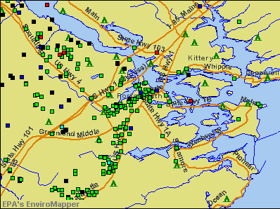
Notable locations in Portsmouth: Sanders Olde Mill (A), Governor John Langdon House and Garden (B), Viking Dock (C), Portsmouth Pier (D), Prescott Park Dock (E), The Hill (F), Portsmouth Fish Pier (G), Meeting House Hill (H), New Hampshire State Commercial Fish Pier (I), Pease Air Force Base Golf Course (J), Water Country Emergency Medical Services (K), City of Portsmouth Fire Department Station 3 (L), Oracle House (M), City of Portsmouth Fire Department Station 2 (N), Plaza 800 (O), Port of Portsmouth Maritime Museum (P), Portsmouth Athenaeum (Q), Portsmouth City Hall (R), Portsmouth Historical Society Building (S), Thomas Thompson House (T). Display/hide their locations on the map
Shopping Centers: Portsmouth Plaza Shopping Center (1), Southgate Plaza Shopping Center (2), Lafayette Plaza Shopping Center (3), Merchants Row Shopping Center (4). Display/hide their locations on the map
Main business address in Portsmouth include: Mueller Group, Inc. (A), Mueller Water Products, Inc. (B), ENVIRONMENTAL POWER CORP (C), BOTTOMLINE TECHNOLOGIES INC /DE/ (D). Display/hide their locations on the map
Churches in Portsmouth include: United Methodist Church (A), Saint Catherine Church (B), Saint Johns Church (C), Advent Christian Church (D), Calvary Baptist Church (E), Temple Israel (F), Christ Episcopal Church (G), First Church of Christ (H), First Church of Christ Scientist (I). Display/hide their locations on the map
Cemeteries: Temple Israel Cemetery (1), North Cemetery (2), Calvary Cemetery (3), Saint Marys Cemetery (4), Union Cemetery (5), South Street Cemetery (6), Point of Grave Burial Ground (7). Display/hide their locations on the map
Lakes, reservoirs, and swamps: North Mill Pond (A), South Mill Pond (B), Great Bog (C). Display/hide their locations on the map
Streams, rivers, and creeks: Hodgson Brook (A), Elwyn Brook (B). Display/hide their locations on the map
Parks in Portsmouth include: Clough Field (1), Elwyn Park (2), Haven Park (3), Haymarket Square (4), Hislop Park (5), South Playground (6), Leary Field (7), Liberty Gardens (8), Market Square (9). Display/hide their locations on the map
Tourist attractions: Warner House Association (Museums; 150 Daniel Street), Wentworth Coolidge State Historic Mansion (Museums; 375 Little Harbor Road), Colonial Dames House (Museums; 154 Market Street), Wentworth Gardner Tobias Lear Association (Historical Places & Services; 50 Mechanic Street), Portsmouth Chamber of Commerce - Visitor & Tourist Information (500 Market Street), Jamaica (37 Taylor Lane), Visit Canada (Tours & Charters; 134 Pleasant Street), Portsmouth Harbor Cruises (Tours & Charters; 64 Ceres Street).
Hotels: Wren's Nest Village Inn (3548 Lafayette Road), Bickford's Family Restaurant (Interstate Highway), Best Inn (383 Woodbury Avenue), Sise Inn (40 Court St), Wren's Nest Village Inn (Ip) (3548 Lafayette Road), Hampton Inn Portsmouth (99 Durgin Lane), National Hotel Realty- Inc (500 Market St. Suite 13), New England Hotel Realty- Inc (500 Market St. Suite 13), The Port Inn (Exit 5 US Route 95).
Courts: New Hampshire State - Portsmouth Court Maintenance (111 Parrott Avenue), Portsmouth District Court Office (111 Parrott Avenue).
Birthplace of: Thomas Westbrook - Colonial, Ronnie James Dio - Musician, Fitz John Porter - Union Army general, Robert Conley (producer/songwriter) - Record producer, Celia Thaxter - Poet, George F. Pearson - Admiral, George Vaughan (New Hampshire) - Colonial governor of New Hampshire, Benning Wentworth - Colonial governor of New Hampshire, Helen Dore Boylston - Novelist, Henry B. Lovering - Politician.
Drinking water stations with addresses in Portsmouth and their reported violations in the past:
NEW CASTLE WATER WORKS (Address: 680 PEVERLY HILL RD , Population served: 800, Purch surface water):Past health violations:STAR ISLAND WATER SYS (Address: 30 MIDDLE ST , Population served: 300, Surface water):Past monitoring violations:
- MCL, Average - Between JUL-2005 and SEP-2005, Contaminant: TTHM. Follow-up actions: St Public Notif requested (NOV-15-2005), St Violation/Reminder Notice (NOV-15-2005), St Public Notif received (DEC-09-2005), St Compliance achieved (MAY-01-2006)
- MCL, Average - Between APR-2005 and JUN-2005, Contaminant: TTHM. Follow-up actions: St Public Notif requested (JUL-22-2005), St Violation/Reminder Notice (JUL-22-2005), St Formal NOV issued (AUG-15-2005), St Public Notif received (AUG-19-2005), St Compliance achieved (MAY-01-2006)
- Monitoring, Routine (IDSE) - Between JAN-01-2010 and JAN-01-2011, Contaminant: Total Haloacetic Acids (HAA5). Follow-up actions: St Public Notif requested (JAN-01-2010), St Violation/Reminder Notice (JAN-01-2010), St Public Notif received (JUN-18-2010), St Compliance achieved (MAR-23-2011)
- Monitoring, Routine (IDSE) - Between JAN-01-2010 and JAN-01-2011, Contaminant: TTHM. Follow-up actions: St Public Notif requested (JAN-01-2010), St Violation/Reminder Notice (JAN-01-2010), St Public Notif received (JUN-18-2010), St Compliance achieved (MAR-23-2011)
Past monitoring violations:MOODY POINT (Population served: 215, Groundwater):
- One routine major monitoring violation
Past health violations:STRATHAM CENTRAL CONDOS (Population served: 174, Groundwater):Past monitoring violations:
- MCL, Monthly (TCR) - In MAR-2009, Contaminant: Coliform. Follow-up actions: St Public Notif requested (MAR-25-2009), St Violation/Reminder Notice (MAR-25-2009), St Formal NOV issued (MAR-31-2009), St Public Notif received (JUN-03-2009), St Compliance achieved (OCT-09-2009)
- MCL, Monthly (TCR) - In NOV-2008, Contaminant: Coliform. Follow-up actions: St Public Notif requested (DEC-09-2008), St Violation/Reminder Notice (DEC-09-2008), St Public Notif received (JAN-26-2009), St Formal NOV issued (MAR-31-2009), St Compliance achieved (OCT-09-2009)
- Lead Consumer Notice - In JUL-01-2012, Contaminant: Lead and Copper Rule. Follow-up actions: St Violation/Reminder Notice (JUL-10-2012), St Compliance achieved (JUL-16-2012)
- Follow-up Or Routine LCR Tap M/R - In APR-01-2009, Contaminant: Lead and Copper Rule. Follow-up actions: St Public Notif requested (MAY-01-2009), St Violation/Reminder Notice (MAY-01-2009), St Public Notif received (MAY-08-2009), St Formal NOV issued (JUN-26-2009), St Compliance achieved (JUL-13-2009)
- Monitoring, Repeat Major (TCR) - In DEC-2008, Contaminant: Coliform (TCR). Follow-up actions: St Public Notif requested (FEB-04-2009), St Violation/Reminder Notice (FEB-04-2009), St Compliance achieved (MAR-03-2009), St Public Notif received (MAR-06-2009)
- 2 routine major monitoring violations
Past monitoring violations:PAWTUCKAWAY FARMS (Population served: 38, Groundwater):
- Monitoring, Source Water (GWR) - Between NOV-02-2011 and DEC-02-2011, Contaminant: E. COLI. Follow-up actions: St Public Notif requested (DEC-19-2011), St Violation/Reminder Notice (DEC-19-2011), St Formal NOV issued (FEB-21-2012), St Compliance achieved (FEB-28-2012), St Public Notif received (JUL-30-2012)
- Monitoring, Repeat Major (TCR) - Between OCT-2011 and DEC-2011, Contaminant: Coliform (TCR). Follow-up actions: St Public Notif requested (DEC-19-2011), St Violation/Reminder Notice (DEC-19-2011), St Formal NOV issued (FEB-21-2012), St Compliance achieved (FEB-28-2012), St Public Notif received (JUL-30-2012)
- 3 routine major monitoring violations
- One regular monitoring violation
Past health violations:US NAVY SERE SCHOOL - MPB (Serves ME, Population served: 33, Groundwater):Past monitoring violations:
- MCL, Monthly (TCR) - In OCT-2013, Contaminant: Coliform. Follow-up actions: St Public Notif requested (OCT-21-2013), St Violation/Reminder Notice (OCT-21-2013), St Public Notif received (OCT-28-2013), St Compliance achieved (MAY-16-2014)
- MCL, Monthly (TCR) - In SEP-2012, Contaminant: Coliform. Follow-up actions: St Public Notif requested (OCT-01-2012), St Violation/Reminder Notice (OCT-01-2012), St Public Notif received (OCT-09-2012), St Compliance achieved (MAY-16-2013)
- MCL, Monthly (TCR) - In APR-2010, Contaminant: Coliform. Follow-up actions: St Public Notif requested (MAY-06-2010), St Violation/Reminder Notice (MAY-06-2010), St Public Notif received (JUN-09-2010), St Compliance achieved (NOV-17-2010)
- Monitoring, Source Water (GWR) - Between APR-01-2010 and MAY-01-2010, Contaminant: E. COLI. Follow-up actions: St Violation/Reminder Notice (MAY-25-2010), St Compliance achieved (AUG-02-2010)
- Monitoring, Repeat Major (TCR) - In AUG-2009, Contaminant: Coliform (TCR). Follow-up actions: St Violation/Reminder Notice (SEP-03-2009), St Public Notif requested (SEP-03-2009), St Public Notif received (OCT-08-2009), St Compliance achieved (OCT-20-2009)
Past health violations:GREAT POND- CABINS 1- 5 (Serves ME, Population served: 30, Groundwater):
- Treatment Technique (SWTR and GWR) - In MAR-2010. Follow-up actions: St Public Notif requested (MAR-08-2010), St Formal NOV issued (MAR-08-2010), St Public Notif received (APR-12-2010), St Compliance achieved (JUL-08-2010)
- Treatment Technique (SWTR and GWR) - In FEB-2010. Follow-up actions: St Public Notif received (MAR-15-2009), St Public Notif requested (MAY-11-2010), St Formal NOV issued (MAY-11-2010), St Compliance achieved (JUL-08-2010)
- Treatment Technique (SWTR and GWR) - In JAN-2010. Follow-up actions: St Public Notif received (MAR-15-2010), St Public Notif requested (MAY-11-2010), St Formal NOV issued (MAY-11-2010), St Compliance achieved (JUL-08-2010)
- Treatment Technique (SWTR and GWR) - In DEC-2009. Follow-up actions: St Public Notif requested (MAR-08-2010), St Formal NOV issued (MAR-08-2010), St Public Notif received (APR-12-2010), St Compliance achieved (JUL-08-2010)
- Treatment Technique (SWTR and GWR) - In NOV-2009. Follow-up actions: St Public Notif requested (MAR-08-2010), St Formal NOV issued (MAR-08-2010), St Public Notif received (MAR-15-2010), St Compliance achieved (JUL-08-2010)
- Treatment Technique (SWTR and GWR) - In OCT-2009. Follow-up actions: St Public Notif requested (MAR-08-2010), St Formal NOV issued (MAR-08-2010), St Public Notif received (MAR-15-2010), St Compliance achieved (JUL-08-2010)
Past health violations:SUGAR AND ICE CREAMERY (Population served: 25, Groundwater):
- MCL, Monthly (TCR) - In APR-2005, Contaminant: Coliform. Follow-up actions: St Violation/Reminder Notice (MAY-09-2005), St Public Notif requested (MAY-09-2005), St Formal NOV issued (MAR-07-2007), St Compliance achieved (MAR-21-2007), St Public Notif received (APR-03-2007), St Compliance achieved (APR-18-2007)
Past monitoring violations:
- 4 routine major monitoring violations
Drinking water stations with addresses in Portsmouth that have no violations reported:
- SHOALS MARINE LABORATORY (Serves ME, Population served: 100, Primary Water Source Type: Surface water)
- GREAT POND- CAMPGROUND (Serves ME, Population served: 36, Primary Water Source Type: Groundwater)
- US NAVY SERE SCHOOL - TRAINING LAB (Serves ME, Population served: 33, Primary Water Source Type: Groundwater)
- WESTMINSTER IRVING/CIRCLE K (Address: 190 COMMERCE WAY , Serves VT, Population served: 32, Primary Water Source Type: Groundwater)
- GREAT POND- CABINS 8 - 12 (Serves ME, Population served: 30, Primary Water Source Type: Groundwater)
| This city: | 2.0 people |
| New Hampshire: | 2.5 people |
| This city: | 47.3% |
| Whole state: | 66.3% |
| This city: | 8.9% |
| Whole state: | 8.3% |
Likely homosexual households (counted as self-reported same-sex unmarried-partner households)
- Lesbian couples: 0.7% of all households
- Gay men: 0.5% of all households
People in group quarters in Portsmouth in 2010:
- 282 people in nursing facilities/skilled-nursing facilities
- 81 people in emergency and transitional shelters (with sleeping facilities) for people experiencing homelessness
- 43 people in other noninstitutional facilities
- 15 people in residential treatment centers for juveniles (non-correctional)
- 12 people in group homes intended for adults
- 12 people in workers' group living quarters and job corps centers
People in group quarters in Portsmouth in 2000:
- 356 people in nursing homes
- 110 people in other noninstitutional group quarters
- 78 people in military ships
- 24 people in homes for the mentally retarded
- 17 people in homes for abused, dependent, and neglected children
- 11 people in other nonhousehold living situations
- 4 people in mental (psychiatric) hospitals or wards
- 4 people in other group homes
- 3 people in religious group quarters
Banks with most branches in Portsmouth (2011 data):
- TD Bank, National Association: Portsmouth Main Branch, 333 State Street Branch, Lafayette Branch, Tv Drive-In Branch. Info updated 2010/10/04: Bank assets: $188,912.6 mil, Deposits: $153,149.8 mil, headquarters in Wilmington, DE, positive income, 1314 total offices, Holding Company: Toronto-Dominion Bank, The
- People's United Bank: Ocean Bank Branch, Portsmouth Branch, Lafayette Road Branch. Info updated 2012/02/16: Bank assets: $27,319.3 mil, Deposits: $20,835.4 mil, headquarters in Bridgeport, CT, positive income, Commercial Lending Specialization, 374 total offices
- Bank of America, National Association: Market Square Branch at 3 Pleasant Street, branch established on 1965/12/15; Islington Street Branch at 848 Islington Street, branch established on 1969/07/14. Info updated 2009/11/18: Bank assets: $1,451,969.3 mil, Deposits: $1,077,176.8 mil, headquarters in Charlotte, NC, positive income, 5782 total offices, Holding Company: Bank Of America Corporation
- RBS Citizens, National Association: Portsmouth Branch at 134 Pleasant Street, branch established on 1871/01/01; Portsmouth Shaw's Branch at 1600-28 Woodbury Avenue, branch established on 1995/06/12. Info updated 2007/09/19: Bank assets: $106,940.6 mil, Deposits: $75,690.2 mil, headquarters in Providence, RI, positive income, 1135 total offices, Holding Company: Uk Financial Investments Limited
- Centrix Bank & Trust: Portsmouth Branch at 163 Deer Street, branch established on 2003/10/06. Info updated 2008/08/12: Bank assets: $757.6 mil, Deposits: $606.8 mil, headquarters in Bedford, NH, positive income, Commercial Lending Specialization, 7 total offices
- Piscataqua Savings Bank: at 15 Pleasant Street, branch established on 1877/01/01. Info updated 2006/11/03: Bank assets: $228.5 mil, Deposits: $190.3 mil, local headquarters, positive income, Mortgage Lending Specialization, 1 total offices
- Federal Savings Bank: 1 Market Square Branch at 1650 Woodbury Avenue, branch established on 1987/06/30. Info updated 2011/07/21: Bank assets: $268.8 mil, Deposits: $180.2 mil, headquarters in Dover, NH, positive income, Commercial Lending Specialization, 5 total offices
- Kennebunk Savings Bank: Portsmouth Nh Branch at 111 Maplewood Avenue, branch established on 2011/02/22. Info updated 2010/05/27: Bank assets: $821.4 mil, Deposits: $660.6 mil, headquarters in Kennebunk, ME, positive income, Commercial Lending Specialization, 15 total offices
- The First Colebrook Bank: Portsmouth Branch at 2400 Lafayette Road, branch established on 2009/08/31. Info updated 2012/03/13: Bank assets: $238.7 mil, Deposits: $207.7 mil, headquarters in Colebrook, NH, positive income, Commercial Lending Specialization, 4 total offices, Holding Company: First Colebrook Bancorp, Inc.
- 3 other banks with 3 local branches
For population 15 years and over in Portsmouth:
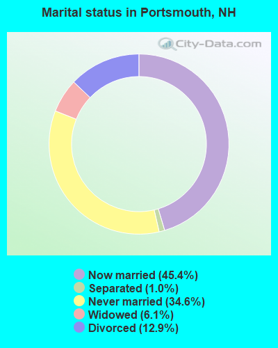
- Never married: 34.6%
- Now married: 45.4%
- Separated: 1.0%
- Widowed: 6.1%
- Divorced: 12.9%
For population 25 years and over in Portsmouth:
- High school or higher: 97.2%
- Bachelor's degree or higher: 63.1%
- Graduate or professional degree: 22.4%
- Unemployed: 2.9%
- Mean travel time to work (commute): 17.2 minutes
| Here: | 8.8 |
| New Hampshire average: | 10.3 |


Graphs represent county-level data. Detailed 2008 Election Results
Neighborhoods in Portsmouth:
(Portsmouth, New Hampshire Neighborhood Map)- Atlantic Heights (Atlantic Hts) neighborhood
- Bersum Gardens neighborhood
- Christian Shore (Islington Creek) neighborhood
- Colonial Pines (Colonial Pines Estates) neighborhood
- Downtown neighborhood
- Elwyn Park (Woodlands) neighborhood
- Frank Jones (Frank Jones) neighborhood
- Gosling Meadows neighborhood
- Haymarket Square neighborhood
- Hillcrest (Lafayette) neighborhood
- Little Harbor neighborhood
- Maple Haven neighborhood
- Meadowbrook neighborhood
- North Mill Pond neighborhood
- Ocean Road (Ocean Rd. Neighborhood) neighborhood
- Osprey Landing (Seacrest Village) neighborhood
- Portsmouth Plains (The Plains) neighborhood
- Sherburne (Sherberne) neighborhood
- South End (S. End) neighborhood
- Strawberry Banke (Strawberry Bank) neighborhood
- The Creek (The Creek Area) neighborhood
- Wibird neighborhood
Religion statistics for Portsmouth, NH (based on Rockingham County data)


| Religion | Adherents | Congregations |
|---|---|---|
| Catholic | 84,697 | 24 |
| Mainline Protestant | 19,072 | 78 |
| Evangelical Protestant | 7,456 | 61 |
| Other | 3,490 | 20 |
| Orthodox | 200 | 1 |
| None | 180,308 | - |
Food Environment Statistics:
| This county: | 1.59 / 10,000 pop. |
| State: | 2.14 / 10,000 pop. |
| This county: | 0.17 / 10,000 pop. |
| New Hampshire: | 0.15 / 10,000 pop. |
| Rockingham County: | 1.86 / 10,000 pop. |
| State: | 1.78 / 10,000 pop. |
| Rockingham County: | 3.31 / 10,000 pop. |
| New Hampshire: | 4.02 / 10,000 pop. |
| Here: | 9.56 / 10,000 pop. |
| New Hampshire: | 9.70 / 10,000 pop. |
| Rockingham County: | 7.6% |
| New Hampshire: | 7.6% |
| Rockingham County: | 23.3% |
| State: | 24.4% |
| Rockingham County: | 16.8% |
| State: | 15.9% |
Health and Nutrition:
| This city: | 56.7% |
| State: | 51.2% |
| Portsmouth: | 56.7% |
| New Hampshire: | 49.1% |
| Here: | 27.6 |
| New Hampshire: | 28.5 |
| Portsmouth: | 17.6% |
| State: | 20.9% |
| Portsmouth: | 8.1% |
| State: | 9.3% |
| Portsmouth: | 7.0 |
| State: | 6.9 |
| This city: | 31.8% |
| New Hampshire: | 34.3% |
| This city: | 63.5% |
| New Hampshire: | 58.1% |
| This city: | 81.5% |
| State: | 79.1% |
More about Health and Nutrition of Portsmouth, NH Residents
| Local government employment and payroll (March 2022) | |||||
| Function | Full-time employees | Monthly full-time payroll | Average yearly full-time wage | Part-time employees | Monthly part-time payroll |
|---|---|---|---|---|---|
| Elementary and Secondary - Instruction | 290 | $2,092,741 | $86,596 | 22 | $36,528 |
| Police Protection - Officers | 65 | $504,630 | $93,162 | 3 | $1,078 |
| Elementary and Secondary - Other Total | 63 | $201,487 | $38,378 | 83 | $199,165 |
| Firefighters | 61 | $456,956 | $89,893 | 0 | $0 |
| Other and Unallocable | 44 | $246,644 | $67,267 | 31 | $55,388 |
| Sewerage | 27 | $172,609 | $76,715 | 3 | $1,334 |
| Financial Administration | 24 | $157,833 | $78,917 | 1 | $4,017 |
| Streets and Highways | 23 | $156,477 | $81,640 | 0 | $0 |
| Police - Other | 22 | $158,143 | $86,260 | 13 | $8,614 |
| Water Supply | 19 | $138,860 | $87,701 | 1 | $1,434 |
| Local Libraries | 16 | $91,723 | $68,792 | 24 | $20,475 |
| Solid Waste Management | 16 | $96,325 | $72,244 | 0 | $0 |
| Other Government Administration | 12 | $96,662 | $96,662 | 0 | $0 |
| Parks and Recreation | 6 | $46,070 | $92,140 | 50 | $3,381 |
| Judicial and Legal | 5 | $44,394 | $106,546 | 1 | $5,270 |
| Housing and Community Development (Local) | 3 | $24,553 | $98,212 | 0 | $0 |
| Health | 2 | $16,704 | $100,224 | 1 | $646 |
| Welfare | 1 | $7,111 | $85,332 | 1 | $2,708 |
| Fire - Other | 1 | $7,104 | $85,248 | 1 | $2,278 |
| Totals for Government | 700 | $4,717,026 | $80,863 | 235 | $342,316 |
Portsmouth government finances - Expenditure in 2021 (per resident):
- Construction - Sewerage: $13,129,000 ($578.04)
Water Utilities: $11,064,000 ($487.12)
Elementary and Secondary Education: $121,000 ($5.33)
General - Other: $97,000 ($4.27)
- Current Operations - Elementary and Secondary Education: $55,369,000 ($2437.77)
General - Other: $30,911,000 ($1360.94)
Police Protection: $16,027,000 ($705.63)
Regular Highways: $14,956,000 ($658.48)
Sewerage: $9,790,000 ($431.03)
Local Fire Protection: $9,501,000 ($418.31)
Central Staff Services: $8,703,000 ($383.17)
Water Utilities: $6,176,000 ($271.91)
Parking Facilities: $3,619,000 ($159.34)
Parks and Recreation: $966,000 ($42.53)
Libraries: $64,000 ($2.82)
General Public Buildings: $2,000 ($0.09)
- General - Interest on Debt: $7,922,000 ($348.79)
- Intergovernmental to Local - Other - Elementary and Secondary Education: $1,000 ($0.04)
- Other Capital Outlay - Elementary and Secondary Education: $630,000 ($27.74)
- Total Salaries and Wages: $31,024,000 ($1365.91)
- Water Utilities - Interest on Debt: $1,038,000 ($45.70)
Portsmouth government finances - Revenue in 2021 (per resident):
- Charges - Sewerage: $16,437,000 ($723.68)
Other: $11,600,000 ($510.72)
Parking Facilities: $5,053,000 ($222.47)
Parks and Recreation: $193,000 ($8.50)
Elementary and Secondary Education School Tuition and Transportation: $83,000 ($3.65)
Elementary and Secondary Education School Lunch: $62,000 ($2.73)
Elementary and Secondary Education - Other: $13,000 ($0.57)
- Federal Intergovernmental - Other: $479,000 ($21.09)
- Local Intergovernmental - Education: $7,463,000 ($328.58)
- Miscellaneous - Interest Earnings: $3,518,000 ($154.89)
General Revenue - Other: $1,032,000 ($45.44)
Fines and Forfeits: $633,000 ($27.87)
Special Assessments: $195,000 ($8.59)
Donations From Private Sources: $155,000 ($6.82)
- Revenue - Water Utilities: $8,415,000 ($370.49)
- State Intergovernmental - Other: $17,174,000 ($756.13)
Education: $16,346,000 ($719.68)
- Tax - Property: $89,201,000 ($3927.31)
Other License: $7,911,000 ($348.30)
Portsmouth government finances - Debt in 2021 (per resident):
- Long Term Debt - Outstanding Unspecified Public Purpose: $181,987,000 ($8012.46)
Beginning Outstanding - Unspecified Public Purpose: $168,934,000 ($7437.77)
Issue, Unspecified Public Purpose: $30,276,000 ($1332.98)
Retired Unspecified Public Purpose: $17,223,000 ($758.29)
Portsmouth government finances - Cash and Securities in 2021 (per resident):
- Bond Funds - Cash and Securities: $11,338,000 ($499.19)
- Other Funds - Cash and Securities: $152,143,000 ($6698.50)
7.69% of this county's 2021 resident taxpayers lived in other counties in 2020 ($114,534 average adjusted gross income)
| Here: | 7.69% |
| New Hampshire average: | 7.66% |
0.01% of residents moved from foreign countries ($203 average AGI)
Rockingham County: 0.01% New Hampshire average: 0.01%
Top counties from which taxpayers relocated into this county between 2020 and 2021:
| from Essex County, MA | |
| from Hillsborough County, NH | |
| from Middlesex County, MA |
6.82% of this county's 2020 resident taxpayers moved to other counties in 2021 ($88,778 average adjusted gross income)
| Here: | 6.82% |
| New Hampshire average: | 6.80% |
0.01% of residents moved to foreign countries ($126 average AGI)
Rockingham County: 0.01% New Hampshire average: 0.01%
Top counties to which taxpayers relocated from this county between 2020 and 2021:
| to Hillsborough County, NH | |
| to Strafford County, NH | |
| to Essex County, MA |
| Businesses in Portsmouth, NH | ||||
| Name | Count | Name | Count | |
|---|---|---|---|---|
| AT&T | 1 | MasterBrand Cabinets | 18 | |
| Ace Hardware | 2 | McDonald's | 1 | |
| Advance Auto Parts | 1 | Motel 6 | 1 | |
| Applebee's | 1 | New Balance | 4 | |
| Banana Republic | 1 | Nike | 6 | |
| Bed Bath & Beyond | 1 | Nissan | 1 | |
| Best Western | 1 | Panera Bread | 1 | |
| Burger King | 1 | Pizza Hut | 1 | |
| CVS | 1 | RadioShack | 2 | |
| Chevrolet | 1 | Rite Aid | 3 | |
| Circle K | 1 | Ruby Tuesday | 1 | |
| Comfort Inn | 1 | Ryder Rental & Truck Leasing | 1 | |
| Decora Cabinetry | 4 | Shaw's | 1 | |
| Domino's Pizza | 1 | Sheraton | 1 | |
| Dunkin Donuts | 6 | Sprint Nextel | 1 | |
| FedEx | 14 | Starbucks | 2 | |
| Ford | 1 | Subway | 2 | |
| GNC | 2 | T-Mobile | 3 | |
| GameStop | 1 | T.J.Maxx | 1 | |
| H&R Block | 1 | Taco Bell | 1 | |
| Hilton | 2 | Toyota | 1 | |
| Holiday Inn | 1 | U-Haul | 1 | |
| Home Depot | 1 | UPS | 17 | |
| Jones New York | 3 | Vans | 1 | |
| Kmart | 1 | Verizon Wireless | 2 | |
| Lane Furniture | 1 | Walmart | 1 | |
| Marriott | 2 | Wendy's | 1 | |
| Marshalls | 1 | YMCA | 1 | |
Strongest AM radio stations in Portsmouth:
- WMYF (1380 AM; 1 kW; PORTSMOUTH, NH; Owner: CAPSTAR TX LIMITED PARTNERSHIP)
- WTSN (1270 AM; 5 kW; DOVER, NH; Owner: GARRISON CITY BROADCASTING, INC.)
- WGIN (930 AM; 10 kW; ROCHESTER, NH; Owner: CAPSTAR TX LIMITED PARTNERSHIP)
- WGIP (1540 AM; 5 kW; EXETER, NH; Owner: CAPSTAR TX LIMITED PARTNERSHIP)
- WRKO (680 AM; 50 kW; BOSTON, MA; Owner: ENTERCOM BOSTON LICENSE, LLC)
- WBZ (1030 AM; 50 kW; BOSTON, MA; Owner: INFINITY BROADCASTING OPERATIONS, INC.)
- WEEI (850 AM; 50 kW; BOSTON, MA; Owner: ENTERCOM BOSTON LICENSE, LLC)
- WWZN (1510 AM; 50 kW; BOSTON, MA; Owner: ROSE CITY RADIO CORPORATION)
- WKOX (1200 AM; 50 kW; FRAMINGHAM, MA; Owner: CAPSTAR TX LIMITED PARTNERSHIP)
- WBIX (1060 AM; 40 kW; NATICK, MA; Owner: LANGER BROADCASTING CORPORATION)
- WDER (1320 AM; 10 kW; DERRY, NH; Owner: BLOUNT COMMUNICATIONS, INC. OF NH)
- WCRN (830 AM; 50 kW; WORCESTER, MA; Owner: CARTER BROADCASTING CORPORATION)
- WALE (990 AM; 50 kW; GREENVILLE, RI; Owner: NORTH AMERICAN BROADCASTING CO., INC.)
Strongest FM radio stations in Portsmouth:
- WHEB (100.3 FM; PORTSMOUTH, NH; Owner: CAPSTAR TX LIMITED PARTNERSHIP)
- WERZ (107.1 FM; EXETER, NH; Owner: CAPSTAR TX LIMITED PARTNERSHIP)
- WUBB (95.3 FM; YORK CENTER, ME; Owner: CAPSTAR TX LIMITED PARTNERSHIP)
- WSHK (105.3 FM; KITTERY, ME; Owner: CITADEL BROADCASTING COMPANY)
- WOKQ (97.5 FM; DOVER, NH; Owner: CITADEL BROADCASTING COMPANY)
- WUNH (91.3 FM; DURHAM, NH; Owner: UNIVERSITY OF NEW HAMPSHIRE)
- WBYY (98.7 FM; SOMERSWORTH, NH; Owner: GARRISON CITY BROADCASTING, INC.)
- WPKQ (103.7 FM; NORTH CONWAY, NH; Owner: CITADEL BROADCASTING COMPANY)
- WSCY (106.9 FM; MOULTONBOROUGH, NH; Owner: NORTHEAST COMMUNICATIONS CORPORATION)
- WSAK (102.1 FM; HAMPTON, NH; Owner: CITADEL BROADCASTING COMPANY)
- WXRV (92.5 FM; HAVERHILL, MA; Owner: BEANPOT BROADCASTING CORP.)
- WMEA (90.1 FM; PORTLAND, ME; Owner: MAINE PUBLIC BROADCASTING CORPORATION)
- WPHX-FM (92.1 FM; SANFORD, ME; Owner: FNX BROADCASTING LLC)
- WSEW (88.5 FM; SANFORD, ME; Owner: WORD RADIO EDUCATIONAL FOUNDATION)
- WNEF (91.7 FM; NEWBURYPORT, MA; Owner: UNIVERSITY OF MASSACHUSETTS)
- WMEX (106.5 FM; FARMINGTON, NH; Owner: WIMMEX, LLC)
- WQSO (96.7 FM; ROCHESTER, NH; Owner: CAPSTAR TX LIMITED PARTNERSHIP)
- WGIR-FM (101.1 FM; MANCHESTER, NH; Owner: CAPSTAR TX LIMITED PARTNERSHIP)
- WQLL (96.5 FM; BEDFORD, NH; Owner: SAGA COMMUNICATIONS OF NEW ENGLAND, LLC)
- WLKZ (104.9 FM; WOLFEBORO, NH; Owner: TELE-MEDIA COMPANY OF NEW HAMPSHIRE, L.L.C.)
TV broadcast stations around Portsmouth:
- WHDN-LP (Channel 26; BOSTON, MA; Owner: GUENTER MARKSTEINER)
- WMEA-TV (Channel 26; BIDDEFORD, ME; Owner: MAINE PUBLIC BROADCASTING CORP.)
- WFXZ-CA (Channel 24; BOSTON, MA; Owner: BOSTON BROADCASTING CORP.)
- WENH-TV (Channel 11; DURHAM, NH; Owner: UNIVERSITY OF NEW HAMPSHIRE)
- WMTW-TV (Channel 8; POLAND SPRING, ME; Owner: WMTW BROADCAST GROUP, LLC)
Medal of Honor Recipients
Medal of Honor Recipients born in Portsmouth: Benjamin F. Falls, Charles H. Foy, Frederick Franklin, Mark G. Ham, Samuel Todd.
- National Bridge Inventory (NBI) Statistics
- 60Number of bridges
- 1,230ft / 375mTotal length
- $132,499,000Total costs
- 1,230,403Total average daily traffic
- 72,213Total average daily truck traffic
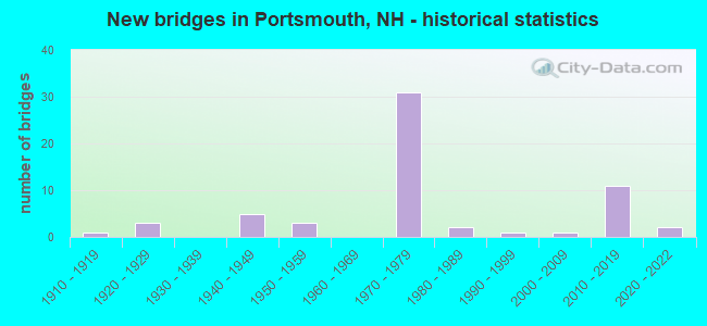
- New bridges - historical statistics
- 11910-1919
- 31920-1929
- 51940-1949
- 31950-1959
- 311970-1979
- 21980-1989
- 11990-1999
- 12000-2009
- 112010-2019
- 22020-2022
FCC Registered Commercial Land Mobile Towers: 4 (See the full list of FCC Registered Commercial Land Mobile Towers in Portsmouth, NH)
FCC Registered Private Land Mobile Towers: 10 (See the full list of FCC Registered Private Land Mobile Towers)
FCC Registered Broadcast Land Mobile Towers: 49 (See the full list of FCC Registered Broadcast Land Mobile Towers)
FCC Registered Microwave Towers: 33 (See the full list of FCC Registered Microwave Towers in this town)
FCC Registered Paging Towers: 3 (See the full list of FCC Registered Paging Towers)
FCC Registered Maritime Coast & Aviation Ground Towers: 17 (See the full list of FCC Registered Maritime Coast & Aviation Ground Towers)
FCC Registered Amateur Radio Licenses: 143 (See the full list of FCC Registered Amateur Radio Licenses in Portsmouth)
FAA Registered Aircraft Manufacturers and Dealers: 10 (See the full list of FAA Registered Manufacturers and Dealers in Portsmouth)
FAA Registered Aircraft: 129 (See the full list of FAA Registered Aircraft)
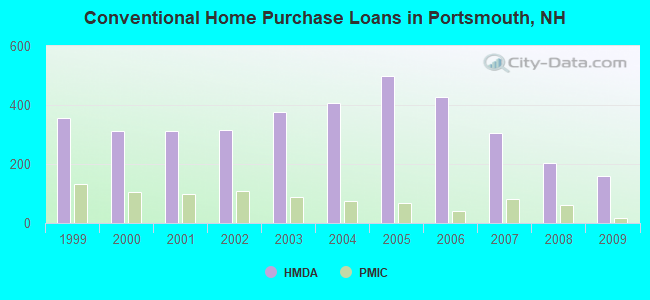
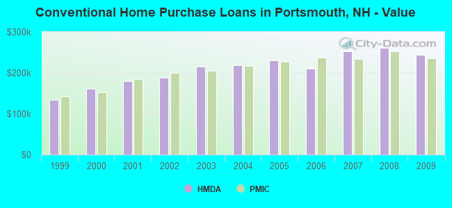
| Home Mortgage Disclosure Act Aggregated Statistics For Year 2009 (Based on 6 full and 1 partial tracts) | ||||||||||||||
| A) FHA, FSA/RHS & VA Home Purchase Loans | B) Conventional Home Purchase Loans | C) Refinancings | D) Home Improvement Loans | E) Loans on Dwellings For 5+ Families | F) Non-occupant Loans on < 5 Family Dwellings (A B C & D) | G) Loans On Manufactured Home Dwelling (A B C & D) | ||||||||
|---|---|---|---|---|---|---|---|---|---|---|---|---|---|---|
| Number | Average Value | Number | Average Value | Number | Average Value | Number | Average Value | Number | Average Value | Number | Average Value | Number | Average Value | |
| LOANS ORIGINATED | 60 | $255,044 | 158 | $243,302 | 603 | $254,695 | 33 | $134,108 | 4 | $467,500 | 61 | $232,144 | 5 | $69,800 |
| APPLICATIONS APPROVED, NOT ACCEPTED | 3 | $175,000 | 8 | $288,875 | 51 | $259,744 | 3 | $171,000 | 0 | $0 | 6 | $282,532 | 1 | $42,000 |
| APPLICATIONS DENIED | 4 | $141,750 | 16 | $181,563 | 156 | $294,041 | 14 | $126,159 | 0 | $0 | 18 | $270,015 | 6 | $50,500 |
| APPLICATIONS WITHDRAWN | 3 | $205,667 | 24 | $310,748 | 125 | $258,253 | 1 | $230,000 | 0 | $0 | 19 | $222,442 | 1 | $187,860 |
| FILES CLOSED FOR INCOMPLETENESS | 2 | $245,000 | 2 | $75,515 | 29 | $269,400 | 1 | $230,000 | 0 | $0 | 2 | $139,500 | 0 | $0 |
Detailed HMDA statistics for the following Tracts: 0691.00 , 0692.00, 0693.00, 0694.00, 0695.00, 0696.00, 0697.00
| Private Mortgage Insurance Companies Aggregated Statistics For Year 2009 (Based on 6 full and 1 partial tracts) | ||||
| A) Conventional Home Purchase Loans | B) Refinancings | |||
|---|---|---|---|---|
| Number | Average Value | Number | Average Value | |
| LOANS ORIGINATED | 18 | $235,722 | 12 | $277,213 |
| APPLICATIONS APPROVED, NOT ACCEPTED | 9 | $303,889 | 9 | $255,778 |
| APPLICATIONS DENIED | 4 | $197,000 | 0 | $0 |
| APPLICATIONS WITHDRAWN | 0 | $0 | 1 | $250,000 |
| FILES CLOSED FOR INCOMPLETENESS | 1 | $175,000 | 1 | $255,000 |
Detailed PMIC statistics for the following Tracts: 0691.00 , 0692.00, 0693.00, 0694.00, 0695.00, 0696.00, 0697.00
2006 - 2018 National Fire Incident Reporting System (NFIRS) incidents
- Fire incident types reported to NFIRS in Portsmouth, NH
- 42541.5%Structure Fires
- 40639.7%Outside Fires
- 13513.2%Mobile Property/Vehicle Fires
- 575.6%Other
 Based on the data from the years 2006 - 2018 the average number of fire incidents per year is 78. The highest number of fires - 100 took place in 2013, and the least - 54 in 2012. The data has a declining trend.
 When looking into fire subcategories, the most incidents belonged to: Structure Fires (41.5%), and Outside Fires (39.7%).
Fire-safe hotels and motels in Portsmouth, New Hampshire:
- Comfort Inn, 1190 Lafayette Rd, Portsmouth, New Hampshire 03801 , Phone: (603) 433-3338, Fax: (603) 431-1639
- Best Western Wynwood Hotel & Suites, 580 Us Hwy 1 Byp, Portsmouth, New Hampshire 03801 , Phone: (603) 436-7600, Fax: (603) 436-7600
- Sheraton Harborside Portsmouth Hotel, 250 Market St, Portsmouth, New Hampshire 03801 , Phone: (603) 431-2300, Fax: (603) 433-5649
- Star Island Conference Center, 10 Vaughan Mall, Ste #8, Portsmouth, New Hampshire 03801 , Phone: (603) 430-6272, Fax: (603) 430-6270
- Port Inn Portsmouth, 505 Us Hwy 1 Byp, Portsmouth, New Hampshire 03801 , Phone: (603) 436-4378, Fax: (603) 436-4378
- Fairfield Inn By Marriott, 650 Borthwick Ave, Portsmouth, New Hampshire 03801 , Phone: (603) 436-6363, Fax: (603) 436-1621
- Hilton Garden Inn Portsmouth Downtown, 100 High St, Portsmouth, New Hampshire 03801 , Phone: (603) 431-1499, Fax: (603) 431-1477
- Homewood Suites By Hilton, 100 Portsmouth Blvd, Portsmouth, New Hampshire 03801 , Phone: (603) 427-5400, Fax: (603) 427-5410
- 3 other hotels and motels
| Most common first names in Portsmouth, NH among deceased individuals | ||
| Name | Count | Lived (average) |
|---|---|---|
| John | 256 | 73.9 years |
| Mary | 230 | 79.8 years |
| Helen | 146 | 82.0 years |
| William | 143 | 74.8 years |
| George | 126 | 75.5 years |
| Robert | 125 | 68.6 years |
| Joseph | 106 | 73.9 years |
| Dorothy | 103 | 81.1 years |
| Charles | 103 | 75.9 years |
| James | 100 | 73.2 years |
| Most common last names in Portsmouth, NH among deceased individuals | ||
| Last name | Count | Lived (average) |
|---|---|---|
| Smith | 53 | 72.0 years |
| Johnson | 40 | 78.6 years |
| Obrien | 38 | 79.5 years |
| Brown | 36 | 74.5 years |
| Clark | 32 | 74.0 years |
| White | 29 | 75.1 years |
| Jones | 26 | 76.3 years |
| Moore | 25 | 75.1 years |
| Wilson | 25 | 76.6 years |
| Sullivan | 24 | 76.2 years |
- 57.3%Utility gas
- 30.5%Fuel oil, kerosene, etc.
- 7.3%Bottled, tank, or LP gas
- 3.6%Electricity
- 0.6%Other fuel
- 0.3%Wood
- 0.3%No fuel used
- 47.0%Utility gas
- 30.2%Electricity
- 12.5%Fuel oil, kerosene, etc.
- 6.2%No fuel used
- 3.2%Bottled, tank, or LP gas
- 0.5%Other fuel
- 0.4%Coal or coke
Portsmouth compared to New Hampshire state average:
- Median house value above state average.
- Unemployed percentage significantly below state average.
- Foreign-born population percentage above state average.
- Renting percentage above state average.
- Percentage of population with a bachelor's degree or higher above state average.
Portsmouth on our top lists:
- #23 on the list of "Top 101 cities with the largest percentage of people in military ships (population 1,000+)"
- #27 on the list of "Top 101 cities with the most local government spending on current operations of parking facilities per resident (population 10,000+)"
- #43 on the list of "Top 101 cities with the biggest property tax revenues per resident (population 10,000+)"
- #50 on the list of "Top 101 cities with the biggest local government total salary and wages expenses per resident (population 10,000+)"
- #90 on the list of "Top 101 cities with the most full-time local library workers per 1000 residents (population 5,000+)"
- #36 (03801) on the list of "Top 101 zip codes with the most museums in 2005"
- #101 (03801) on the list of "Top 101 zip codes with the most full service restaurants in 2005"
- #9 on the list of "Top 101 counties with the largest decrease in the number of births per 1000 residents 2000-2006 to 2007-2013 (pop 50,000+)"
- #14 on the list of "Top 101 counties with the best general health status score of residents (1-5), 3 years of data"
- #16 on the list of "Top 101 counties with the lowest number of births per 1000 residents 2007-2013"
- #22 on the list of "Top 101 counties with the lowest Particulate Matter (PM10) Annual air pollution readings in 2012 (µg/m3)"
- #36 on the list of "Top 101 counties with the highest percentage of residents that visited a dentist within the past year"

|
|
Total of 384 patent applications in 2008-2024.