Bridge Statistics for Portsmouth, New Hampshire (NH)
Condition, Traffic, Stress, Structural Evaluation, Project Costs
- National Bridge Inventory (NBI) Statistics
- 60Number of bridges
- 1,230ft / 375mTotal length
- $132,499,000Total costs
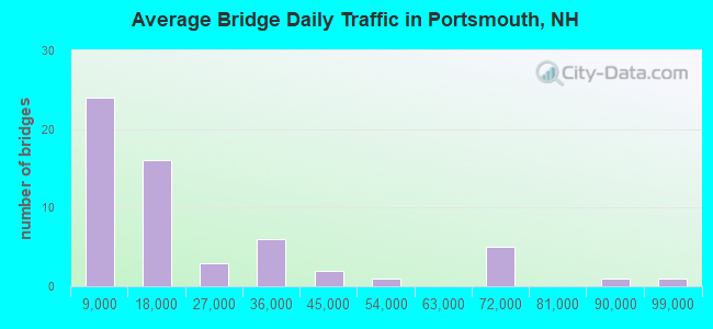
- 1,230,403Total average daily traffic
- 72,213Total average daily truck traffic
- National Bridge Inventory (NBI) Registered Bridges for Portsmouth
- No street view available for this location
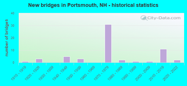
- New bridges - historical statistics
- 11910-1919
- 31920-1929
- 51940-1949
- 31950-1959
- 311970-1979
- 21980-1989
- 11990-1999
- 12000-2009
- 112010-2019
- 22020-2022
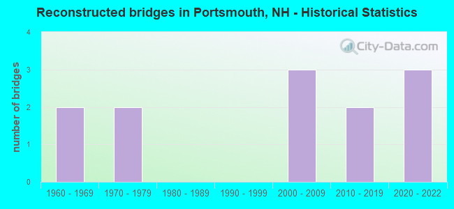
- Reconstructed bridges - Historical Statistics
- 21960-1969
- 21970-1979
- 01980-1989
- 01990-1999
- 32000-2009
- 22010-2019
- 32020-2022
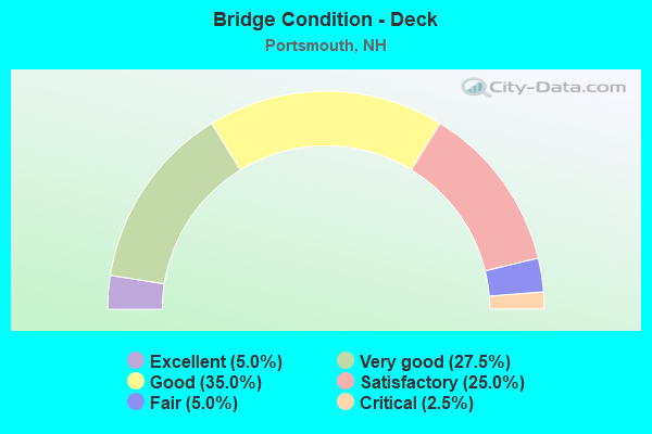
- Bridge Condition - Deck
- 5.0%Excellent
- 27.5%Very good
- 35.0%Good
- 25.0%Satisfactory
- 5.0%Fair
- 2.5%Critical
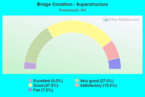
- Bridge Condition - Superstructure
- 5.0%Excellent
- 27.5%Very good
- 47.5%Good
- 12.5%Satisfactory
- 7.5%Fair
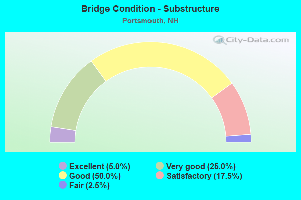
- Bridge Condition - Substructure
- 5.0%Excellent
- 25.0%Very good
- 50.0%Good
- 17.5%Satisfactory
- 2.5%Fair
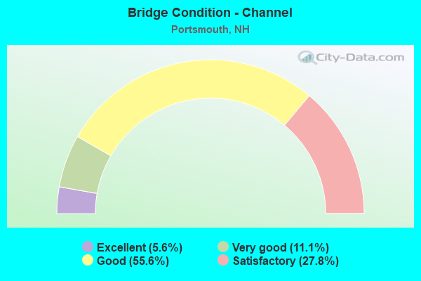
- Bridge Condition - Channel
- 5.6%Excellent
- 11.1%Very good
- 55.6%Good
- 27.8%Satisfactory
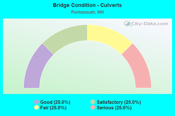
- Bridge Condition - Culverts
- 25.0%Good
- 25.0%Satisfactory
- 25.0%Fair
- 25.0%Serious
Find on map >> Show street view
Structure Number: 1NH0BR1, Location: 200 M SE OF SR103 (Lat: 43.084831, Lng: -70.741411), Route carried "on" structure: Other road , Year Built: 1913, Year Reconstructed: 2015, Status: Open, Structure Length: 9.14m (29.99ft), Average Daily Traffic: 7,000 (year 2011), Truck Traffic: 10%, Average Future Daily Traffic: 8,000 (year 2040), Design Load: HS 20, Features Intersected: PISCATAQUA R BACK CHAN, Facility Carried by Structure: WALKER STREET
Minimum Vertical Clearance: 0.00m, Kilometerpoint: 0.000, Lanes on structure: 2, Owner: Navy/Marines, Approaching Roadway Width: 10.6m (34.8ft), Skew: 30 degrees, Material/Design: Steel, Design/Construction: Stringer/Multi-beam, Number Of Spans In Main Unit: 4, Length of Maximum Span: 22.9m (75.1ft), Curb or Sidewalk Widths: Left: 1.8m (5.9ft), Right: 1.8m (5.9ft), Curb-To-Curb Width: 10.3m (33.8ft), Out-to-Out Width: 15.4m (50.5ft)
Condition: Deck: Good, Superstructure: Very good, Substructure: Satisfactory, Channel: Very good, Operating Rating: 96.9 metric tons, Method Used To Determine Operating Rating: Load and Resistance Factor Rating (LRFR) rating reported by rating factor(RF) method using HL-93 loadings, Inventory Rating: 74.8 metric tons, Method Used To Determine Inventory Rating: Load and Resistance Factor Rating (LRFR) rating reported by rating factor(RF) method using HL-93 loadings, Structural Evaluation: Equal to present minimum criteria, Deck Geometry: Meets minimum limits, Waterway Adequacy: Equal to present desirable criteria, Approach Roadway Alignment: Equal to present desirable criteria, Length Of Structure Improvement: 9.14m (29.99ft), Designated Inspection Frequency: Every 24 months, Underwater Inspection Frequency: Every 60 months, Inspection Date: August 2021, Underwater Inspection Date: August 2019, Bridge Improvement Cost: $22,000, Roadway Improvement Cost: $12,000, Total Project Cost: $34,000 ( Estimate for 2021), Deck Structure Type: Concrete Cast-file-Place
Find on map >> Show street view
Structure Number: 1NH0BR2, Location: 0.1 KM SOUTH OF SR 103 (Lat: 43.085083, Lng: -70.735778), Route carried "on" structure: Other road , Year Built: 1941, Year Reconstructed: 1984, Status: Open, Structure Length: 6.10m (20.01ft), Average Daily Traffic: 4,000 (year 2011), Truck Traffic: 10%, Average Future Daily Traffic: 4,200 (year 2040), Design Load: HS 15, Features Intersected: PISCATAQUA RIV BACK CHNL, Facility Carried by Structure: WYMAN AVE
Minimum Vertical Clearance: 30+ m (98+ ft), Kilometerpoint: 0.000, Lanes on structure: 2, Owner: Navy/Marines, Approaching Roadway Width: 9.1m (29.9ft), Material/Design: Steel continuous, Design/Construction: Girder and Floorbeam System, Number Of Spans In Main Unit: 2, Length of Maximum Span: 30.5m (100.1ft), Curb or Sidewalk Widths: Left: 1.4m (4.6ft), Right: 0.5m (1.6ft), Curb-To-Curb Width: 9.1m (29.9ft), Out-to-Out Width: 11.3m (37.1ft)
Condition: Deck: Satisfactory, Superstructure: Fair, Substructure: Satisfactory, Channel: Good, Operating Rating: 35.6 metric tons, Method Used To Determine Operating Rating: Load and Resistance Factor Rating (LRFR) rating reported by rating factor(RF) method using HL-93 loadings, Inventory Rating: 27.5 metric tons, Method Used To Determine Inventory Rating: Load and Resistance Factor Rating (LRFR) rating reported by rating factor(RF) method using HL-93 loadings, Structural Evaluation: Somewhat better than minimum adequacy, Deck Geometry: Meets minimum limits, Waterway Adequacy: Equal to present desirable criteria, Approach Roadway Alignment: Equal to present desirable criteria, Length Of Structure Improvement: 6.10m (20.01ft), Designated Inspection Frequency: Every 24 months, Critical Feature Inspection Frequency: Every 24 months, Underwater Inspection Frequency: Every 60 months, Inspection Date: August 2021, Critical Feature Inspection Date: August 2021, Underwater Inspection Date: August 2019, Bridge Improvement Cost: $467,000, Roadway Improvement Cost: $34,000, Total Project Cost: $501,000 ( Estimate for 2021), Deck Structure Type: Concrete Cast-file-Place, Wearing Surface/Protective System: Wearing Surface: Bituminous
Find on map >> Show street view
Structure Number: 217010400126, Location: 0.6 MI N GREENLAND TL (Lat: 43.050247, Lng: -70.812136), Route carried "on" structure: Interstate 95, Year Built: 1972, Status: Open, Structure Length: 2.38m (7.81ft), Average Daily Traffic: 39,762 (year 2020), Truck Traffic: 6%, Average Future Daily Traffic: 58,847 (year 2042), Design Load: HS 20+Mod, Features Intersected: PAR
Minimum Vertical Clearance: 30+ m (98+ ft), Kilometerpoint: 6.265, Lanes on structure: 4, Base Highway Network: Yes, Toll: On toll road, Owner: State Toll Authority, Approaching Roadway Width: 21.3m (69.9ft), Skew: 5 degrees, Material/Design: Steel, Design/Construction: Stringer/Multi-beam, Number Of Spans In Main Unit: 1, Length of Maximum Span: 22.6m (74.1ft), Curb or Sidewalk Widths: Left: 0.2m (0.7ft), Right: 0.2m (0.7ft), Curb-To-Curb Width: 21.3m (69.9ft), Out-to-Out Width: 22.4m (73.5ft)
Condition: Deck: Good, Superstructure: Good, Substructure: Good, Operating Rating: 42.0 metric tons, Method Used To Determine Operating Rating: Load Factor (LF), Inventory Rating: 25.1 metric tons, Method Used To Determine Inventory Rating: Load Factor (LF), Structural Evaluation: Equal to present minimum criteria, Deck Geometry: Better than present minimum criteria, Underclear: Meets minimum limits, Approach Roadway Alignment: Equal to present desirable criteria, Length Of Structure Improvement: 2.38m (7.81ft), Designated Inspection Frequency: Every 24 months, Inspection Date: June 2021, Bridge Improvement Cost: $2,718,000, Roadway Improvement Cost: $200,000, Total Project Cost: $3,142,000 ( Estimate for 2022), Deck Structure Type: Concrete Cast-file-Place, Wearing Surface/Protective System: Wearing Surface: Bituminous, Membrane: Other
Find on map >> Show street view
Structure Number: 217010500125, Location: 0.6 MI N GREENLAND TL (Lat: 43.050503, Lng: -70.811475), Route carried "on" structure: Interstate 95, Year Built: 1972, Status: Open, Structure Length: 2.38m (7.81ft), Average Daily Traffic: 41,709 (year 2020), Truck Traffic: 6%, Average Future Daily Traffic: 61,729 (year 2042), Design Load: HS 20+Mod, Features Intersected: PAR
Minimum Vertical Clearance: 30+ m (98+ ft), Kilometerpoint: 19.859, Lanes on structure: 4, Base Highway Network: Yes, Toll: On toll road, Owner: State Toll Authority, Approaching Roadway Width: 21.3m (69.9ft), Skew: 5 degrees, Material/Design: Steel, Design/Construction: Stringer/Multi-beam, Number Of Spans In Main Unit: 1, Length of Maximum Span: 22.6m (74.1ft), Curb or Sidewalk Widths: Left: 0.2m (0.7ft), Right: 0.2m (0.7ft), Curb-To-Curb Width: 21.3m (69.9ft), Out-to-Out Width: 35.1m (115.2ft)
Condition: Deck: Good, Superstructure: Good, Substructure: Good, Operating Rating: 42.0 metric tons, Method Used To Determine Operating Rating: Load Factor (LF), Inventory Rating: 25.1 metric tons, Method Used To Determine Inventory Rating: Load Factor (LF), Structural Evaluation: Equal to present minimum criteria, Deck Geometry: Better than present minimum criteria, Underclear: Meets minimum limits, Approach Roadway Alignment: Equal to present desirable criteria, Length Of Structure Improvement: 2.38m (7.81ft), Designated Inspection Frequency: Every 24 months, Inspection Date: June 2021, Bridge Improvement Cost: $2,718,000, Roadway Improvement Cost: $200,000, Total Project Cost: $3,142,000 ( Estimate for 2022), Deck Structure Type: Concrete Cast-file-Place, Wearing Surface/Protective System: Wearing Surface: Bituminous, Membrane: Other
Find on map >> Show street view
Structure Number: 217013600127, Location: 3.0MI S OF MAINE S/L (Lat: 43.058031, Lng: -70.804217), Route carried "on" structure: State highway 33, Year Built: 1971, Status: Open, Structure Length: 8.69m (28.51ft), Average Daily Traffic: 17,724 (year 2020), Truck Traffic: 5%, Average Future Daily Traffic: 26,231 (year 2042), Design Load: HS 20+Mod, Features Intersected: I-95
Minimum Vertical Clearance: 30+ m (98+ ft), Kilometerpoint: 11.508, Lanes on structure: 4, Lanes under structure: 8, Base Highway Network: Yes, Owner: State Toll Authority, Approaching Roadway Width: 21.3m (69.9ft), Skew: 3 degrees, Material/Design: Steel continuous, Design/Construction: Stringer/Multi-beam, Number Of Spans In Main Unit: 2, Length of Maximum Span: 43.9m (144.0ft), Curb or Sidewalk Widths: Left: 0.2m (0.7ft), Right: 0.2m (0.7ft), Curb-To-Curb Width: 21.3m (69.9ft), Out-to-Out Width: 22.8m (74.8ft)
Condition: Deck: Satisfactory, Superstructure: Good, Substructure: Good, Operating Rating: 75.3 metric tons, Method Used To Determine Operating Rating: Load Factor (LF), Inventory Rating: 45.4 metric tons, Method Used To Determine Inventory Rating: Load Factor (LF), Structural Evaluation: Better than present minimum criteria, Deck Geometry: Superior to present desirable criteria, Underclear: Somewhat better than minimum adequacy, Approach Roadway Alignment: Equal to present desirable criteria, Length Of Structure Improvement: 8.69m (28.51ft), Designated Inspection Frequency: Every 24 months, Inspection Date: June 2021, Bridge Improvement Cost: $2,718,000, Roadway Improvement Cost: $200,000, Total Project Cost: $3,142,000 ( Estimate for 2022), Deck Structure Type: Concrete Cast-file-Place, Wearing Surface/Protective System: Wearing Surface: Bituminous, Membrane: Other
Find on map >> Show street view
Structure Number: 217014400115, Location: .8 MI JCT I-95 (Lat: 43.057517, Lng: -70.797492), Route carried "on" structure: State highway 101, Year Built: 1971, Status: Open, Structure Length: 2.13m (6.99ft), Average Daily Traffic: 14,279 (year 2020), Truck Traffic: 5%, Average Future Daily Traffic: 21,132 (year 2042), Design Load: HS 20+Mod, Features Intersected: PAR, Facility Carried by Structure: NH 33
Minimum Vertical Clearance: 30+ m (98+ ft), Kilometerpoint: 12.059, Lanes on structure: 4, Owner: State Highway Agency, Approaching Roadway Width: 15.8m (51.8ft), Skew: 5 degrees, Material/Design: Steel, Design/Construction: Stringer/Multi-beam, Number Of Spans In Main Unit: 1, Length of Maximum Span: 19.2m (63.0ft), Curb or Sidewalk Widths: Left: 0.2m (0.7ft), Right: 0.2m (0.7ft), Curb-To-Curb Width: 15.8m (51.8ft), Out-to-Out Width: 17.2m (56.4ft)
Condition: Deck: Fair, Superstructure: Good, Substructure: Fair, Operating Rating: 43.3 metric tons, Method Used To Determine Operating Rating: Load Factor (LF), Inventory Rating: 25.9 metric tons, Method Used To Determine Inventory Rating: Load Factor (LF), Structural Evaluation: Somewhat better than minimum adequacy, Deck Geometry: Meets minimum limits, Underclear: High priority of replacement, Approach Roadway Alignment: Equal to present desirable criteria, Length Of Structure Improvement: 2.13m (6.99ft), Designated Inspection Frequency: Every 24 months, Inspection Date: June 2021, Bridge Improvement Cost: $2,718,000, Roadway Improvement Cost: $200,000, Total Project Cost: $3,142,000 ( Estimate for 2022), Deck Structure Type: Concrete Cast-file-Place, Wearing Surface/Protective System: Wearing Surface: Bituminous, Membrane: Other
Find on map >> Show street view
Structure Number: 217014400125, Location: 2.8MI S OF MAINE S/L (Lat: 43.060233, Lng: -70.800889), Route carried "on" structure: City street , Year Built: 1971, Year Reconstructed: 2011, Status: Open, Structure Length: 7.41m (24.31ft), Average Daily Traffic: 1,352 (year 2020), Truck Traffic: 4%, Average Future Daily Traffic: 2,000 (year 2042), Design Load: HS 20+Mod, Features Intersected: I-95, Facility Carried by Structure: SHERBURNE ROAD
Minimum Vertical Clearance: 30+ m (98+ ft), Kilometerpoint: 0.256, Lanes on structure: 2, Lanes under structure: 8, Owner: State Toll Authority, Approaching Roadway Width: 12.2m (40.0ft), Skew: 1 degrees, Material/Design: Steel continuous, Design/Construction: Stringer/Multi-beam, Number Of Spans In Main Unit: 2, Length of Maximum Span: 38.1m (125.0ft), Curb or Sidewalk Widths: Left: 1.5m (4.9ft), Right: 0.2m (0.7ft), Curb-To-Curb Width: 12.2m (40.0ft), Out-to-Out Width: 14.5m (47.6ft)
Condition: Deck: Very good, Superstructure: Good, Substructure: Good, Operating Rating: 67.0 metric tons, Method Used To Determine Operating Rating: Load Factor (LF), Inventory Rating: 40.0 metric tons, Method Used To Determine Inventory Rating: Load Factor (LF), Structural Evaluation: Better than present minimum criteria, Deck Geometry: Better than present minimum criteria, Underclear: Somewhat better than minimum adequacy, Approach Roadway Alignment: Equal to present desirable criteria, Length Of Structure Improvement: 7.41m (24.31ft), Designated Inspection Frequency: Every 24 months, Inspection Date: June 2021, Bridge Improvement Cost: $2,718,000, Roadway Improvement Cost: $200,000, Total Project Cost: $3,142,000 ( Estimate for 2022), Deck Structure Type: Concrete Cast-file-Place, Wearing Surface/Protective System: Wearing Surface: Integral Concrete
Find on map >> Show street view
Structure Number: 217015400101, Location: 0.75 MI FROM JCT I-95 (Lat: 43.056872, Lng: -70.788528), Route carried "on" structure: State highway 101, Year Built: 2010, Status: Open, Structure Length: 1.52m (4.99ft), Average Daily Traffic: 13,897 (year 2020), Truck Traffic: 5%, Average Future Daily Traffic: 20,567 (year 2042), Design Load: HS 25 or greater, Features Intersected: PAR, Facility Carried by Structure: NH 33
Minimum Vertical Clearance: 30+ m (98+ ft), Kilometerpoint: 12.806, Lanes on structure: 2, Owner: City or Municipal Highway Agency, Approaching Roadway Width: 14.0m (45.9ft), Skew: 13 degrees, Material/Design: Concrete, Design/Construction: Slab, Number Of Spans In Main Unit: 1, Length of Maximum Span: 13.7m (44.9ft), Curb or Sidewalk Widths: Left: 1.8m (5.9ft), Right: 0.2m (0.7ft), Curb-To-Curb Width: 12.2m (40.0ft), Out-to-Out Width: 15.2m (49.9ft)
Condition: Deck: Very good, Superstructure: Very good, Substructure: Very good, Operating Rating: 89.8 metric tons, Method Used To Determine Operating Rating: Load Factor (LF), Inventory Rating: 89.8 metric tons, Method Used To Determine Inventory Rating: Load Factor (LF), Structural Evaluation: Equal to present desirable criteria, Deck Geometry: Somewhat better than minimum adequacy, Underclear: High priority of replacement, Approach Roadway Alignment: Better than present minimum criteria, Length Of Structure Improvement: 1.52m (4.99ft), Designated Inspection Frequency: Every 24 months, Inspection Date: October 2021, Bridge Improvement Cost: $2,718,000, Roadway Improvement Cost: $200,000, Total Project Cost: $3,142,000 ( Estimate for 2022), Deck Structure Type: Concrete Precast Panels, Wearing Surface/Protective System: Wearing Surface: Bituminous
Find on map >> Show street view
Structure Number: 217016100062, Location: 3.0MI N. OF RYE TL (Lat: 43.050861, Lng: -70.770631), Route carried "on" structure: US 1, Year Built: 2000, Status: Open, Structure Length: 0.61m (2.00ft), Average Daily Traffic: 15,600 (year 2020), Truck Traffic: 6%, Average Future Daily Traffic: 23,088 (year 2042), Design Load: HS 25 or greater, Features Intersected: SAGAMORE CREEK
Minimum Vertical Clearance: 30+ m (98+ ft), Kilometerpoint: 23.223, Lanes on structure: 4, Base Highway Network: Yes, Owner: State Highway Agency, Approaching Roadway Width: 20.1m (65.9ft), Material/Design: Prestressed concrete, Design/Construction: Box Beam or Girders - Single/Spread, Number Of Spans In Main Unit: 1, Length of Maximum Span: 5.2m (17.1ft), Curb or Sidewalk Widths: Left: 1.5m (4.9ft), Right: 1.5m (4.9ft), Curb-To-Curb Width: 10.9m (35.8ft), Out-to-Out Width: 11.5m (37.7ft)
Condition: Deck: Very good, Superstructure: Very good, Substructure: Very good, Channel: Good, Operating Rating: 72.5 metric tons, Method Used To Determine Operating Rating: Load Factor (LF), Inventory Rating: 43.5 metric tons, Method Used To Determine Inventory Rating: Load Factor (LF), Structural Evaluation: Equal to present desirable criteria, Deck Geometry: High priority of replacement, Waterway Adequacy: Equal to present desirable criteria, Approach Roadway Alignment: Equal to present desirable criteria, Length Of Structure Improvement: 0.61m (2.00ft), Designated Inspection Frequency: Every 24 months, Inspection Date: June 2021, Bridge Improvement Cost: $2,718,000, Roadway Improvement Cost: $200,000, Total Project Cost: $3,142,000 ( Estimate for 2022), Deck Structure Type: Concrete Precast Panels, Wearing Surface/Protective System: Wearing Surface: Bituminous, Membrane: Preformed Fabric, Deck Protection: Epoxy Coated Reinforcing
Find on map >> Show street view
Structure Number: 217018000122, Location: SP TPK,I-95 INTERCHANGE (Lat: 43.069625, Lng: -70.787756), Route carried "on" structure: Ramp State highway 16, Year Built: 1972, Status: Open, Structure Length: 3.54m (11.61ft), Average Daily Traffic: 4,071 (year 2020), Truck Traffic: 4%, Average Future Daily Traffic: 6,025 (year 2042), Design Load: HS 20+Mod, Features Intersected: I-95 NB RAMP, Facility Carried by Structure: I-95 SB CONNECTOR
Minimum Vertical Clearance: 30+ m (98+ ft), Kilometerpoint: 0.631, Lanes on structure: 2, Lanes under structure: 2, Base Highway Network: Yes, Owner: State Toll Authority, Approaching Roadway Width: 12.2m (40.0ft), Skew: 5 degrees, Material/Design: Steel, Design/Construction: Stringer/Multi-beam, Number Of Spans In Main Unit: 1, Length of Maximum Span: 34.7m (113.8ft), Curb or Sidewalk Widths: Left: 0.2m (0.7ft), Right: 0.2m (0.7ft), Curb-To-Curb Width: 12.3m (40.4ft), Out-to-Out Width: 13.7m (44.9ft)
Condition: Deck: Good, Superstructure: Good, Substructure: Good, Operating Rating: 49.4 metric tons, Method Used To Determine Operating Rating: Load Factor (LF), Inventory Rating: 29.6 metric tons, Method Used To Determine Inventory Rating: Load Factor (LF), Structural Evaluation: Better than present minimum criteria, Deck Geometry: Superior to present desirable criteria, Underclear: Somewhat better than minimum adequacy, Approach Roadway Alignment: Equal to present desirable criteria, Length Of Structure Improvement: 3.54m (11.61ft), Designated Inspection Frequency: Every 24 months, Inspection Date: June 2021, Bridge Improvement Cost: $2,718,000, Roadway Improvement Cost: $200,000, Total Project Cost: $3,142,000 ( Estimate for 2022), Deck Structure Type: Concrete Cast-file-Place, Wearing Surface/Protective System: Wearing Surface: Bituminous, Membrane: Other
Find on map >> Show street view
Structure Number: 217018300087, Location: 0.6MI FROM JCT RT 1 (Lat: 43.061814, Lng: -70.774239), Route carried "on" structure: State highway , Year Built: 2013, Status: Open, Structure Length: 4.14m (13.58ft), Average Daily Traffic: 5,711 (year 2020), Truck Traffic: 5%, Average Future Daily Traffic: 8,452 (year 2042), Design Load: HL 93, Features Intersected: US 1 BYPASS, Facility Carried by Structure: NH 33
Minimum Vertical Clearance: 30+ m (98+ ft), Kilometerpoint: 14.125, Lanes on structure: 2, Lanes under structure: 4, Owner: State Highway Agency, Approaching Roadway Width: 9.1m (29.9ft), Material/Design: Steel continuous, Design/Construction: Stringer/Multi-beam, Number Of Spans In Main Unit: 2, Length of Maximum Span: 20.4m (66.9ft), Curb or Sidewalk Widths: Left: 1.5m (4.9ft), Right: 0.2m (0.7ft), Curb-To-Curb Width: 9.0m (29.5ft), Out-to-Out Width: 11.6m (38.1ft)
Condition: Deck: Very good, Superstructure: Very good, Substructure: Very good, Operating Rating: 59.2 metric tons, Method Used To Determine Operating Rating: Load and Resistance Factor (LRFR), Inventory Rating: 45.7 metric tons, Method Used To Determine Inventory Rating: Load and Resistance Factor (LRFR), Structural Evaluation: Equal to present desirable criteria, Deck Geometry: High priority of replacement, Underclear: High priority of replacement, Approach Roadway Alignment: Better than present minimum criteria, Length Of Structure Improvement: 4.14m (13.58ft), Designated Inspection Frequency: Every 24 months, Inspection Date: June 2021, Bridge Improvement Cost: $2,718,000, Roadway Improvement Cost: $200,000, Total Project Cost: $3,142,000 ( Estimate for 2022), Deck Structure Type: Concrete Cast-file-Place, Wearing Surface/Protective System: Wearing Surface: Bituminous, Membrane: Preformed Fabric, Deck Protection: Epoxy Coated Reinforcing
Find on map >> Show street view
Structure Number: 217018300121, Location: SP TPK,I-95 INTERCHANGE (Lat: 43.070017, Lng: -70.786772), Route carried "on" structure: Ramp State highway 95, Year Built: 1972, Status: Open, Structure Length: 4.75m (15.58ft), Average Daily Traffic: 4,071 (year 2020), Truck Traffic: 4%, Average Future Daily Traffic: 6,025 (year 2042), Design Load: HS 20+Mod, Features Intersected: I-95 NB
Minimum Vertical Clearance: 30+ m (98+ ft), Kilometerpoint: 0.534, Lanes on structure: 2, Lanes under structure: 3, Base Highway Network: Yes, Owner: State Toll Authority, Approaching Roadway Width: 12.5m (41.0ft), Skew: 4 degrees, Material/Design: Steel, Design/Construction: Stringer/Multi-beam, Number Of Spans In Main Unit: 1, Length of Maximum Span: 46.9m (153.9ft), Curb or Sidewalk Widths: Left: 0.2m (0.7ft), Right: 0.2m (0.7ft), Curb-To-Curb Width: 12.3m (40.4ft), Out-to-Out Width: 13.7m (44.9ft)
Condition: Deck: Good, Superstructure: Good, Substructure: Satisfactory, Operating Rating: 49.4 metric tons, Method Used To Determine Operating Rating: Load Factor (LF), Inventory Rating: 29.6 metric tons, Method Used To Determine Inventory Rating: Load Factor (LF), Structural Evaluation: Equal to present minimum criteria, Deck Geometry: Superior to present desirable criteria, Underclear: Somewhat better than minimum adequacy, Approach Roadway Alignment: Equal to present desirable criteria, Length Of Structure Improvement: 4.75m (15.58ft), Designated Inspection Frequency: Every 24 months, Inspection Date: June 2021, Bridge Improvement Cost: $2,718,000, Roadway Improvement Cost: $200,000, Total Project Cost: $3,142,000 ( Estimate for 2022), Deck Structure Type: Concrete Cast-file-Place, Wearing Surface/Protective System: Wearing Surface: Bituminous, Membrane: Other
Find on map >> Show street view
Structure Number: 217018400124, Location: SP TPK,I-95 INTERCHANGE (Lat: 43.070769, Lng: -70.787419), Route carried "on" structure: Interstate 95, Year Built: 1972, Status: Open, Structure Length: 3.87m (12.70ft), Average Daily Traffic: 26,689 (year 2020), Truck Traffic: 6%, Average Future Daily Traffic: 39,499 (year 2042), Design Load: HS 20+Mod, Features Intersected: NB RAMP
Minimum Vertical Clearance: 30+ m (98+ ft), Kilometerpoint: 3.187, Lanes on structure: 3, Lanes under structure: 2, Base Highway Network: Yes, Owner: State Toll Authority, Approaching Roadway Width: 17.7m (58.1ft), Skew: 5 degrees, Material/Design: Steel, Design/Construction: Stringer/Multi-beam, Number Of Spans In Main Unit: 1, Length of Maximum Span: 38.1m (125.0ft), Curb or Sidewalk Widths: Left: 0.2m (0.7ft), Right: 0.2m (0.7ft), Curb-To-Curb Width: 17.8m (58.4ft), Out-to-Out Width: 19.2m (63.0ft)
Condition: Deck: Good, Superstructure: Good, Substructure: Good, Operating Rating: 51.3 metric tons, Method Used To Determine Operating Rating: Load Factor (LF), Inventory Rating: 30.7 metric tons, Method Used To Determine Inventory Rating: Load Factor (LF), Structural Evaluation: Better than present minimum criteria, Deck Geometry: Better than present minimum criteria, Underclear: Better than present minimum criteria, Approach Roadway Alignment: Equal to present desirable criteria, Length Of Structure Improvement: 3.87m (12.70ft), Designated Inspection Frequency: Every 24 months, Inspection Date: June 2021, Bridge Improvement Cost: $2,718,000, Roadway Improvement Cost: $200,000, Total Project Cost: $3,142,000 ( Estimate for 2022), Deck Structure Type: Concrete Cast-file-Place, Wearing Surface/Protective System: Wearing Surface: Bituminous, Membrane: Other
Find on map >> Show street view
Structure Number: 217018800097, Location: 1.0 MI FROM JCT US 1 (Lat: 43.065828, Lng: -70.776469), Route carried "on" structure: City street , Year Built: 2015, Status: Open, Structure Length: 4.14m (13.58ft), Average Daily Traffic: 4,185 (year 2020), Truck Traffic: 5%, Average Future Daily Traffic: 6,193 (year 2042), Design Load: HL 93, Features Intersected: US 1 BYPASS, Facility Carried by Structure: ISLINGTON STREET
Minimum Vertical Clearance: 30+ m (98+ ft), Kilometerpoint: 1.217, Lanes on structure: 2, Lanes under structure: 4, Owner: State Highway Agency, Approaching Roadway Width: 9.0m (29.5ft), Material/Design: Steel continuous, Design/Construction: Stringer/Multi-beam, Number Of Spans In Main Unit: 2, Length of Maximum Span: 20.4m (66.9ft), Curb or Sidewalk Widths: Left: 0.2m (0.7ft), Right: 1.5m (4.9ft), Curb-To-Curb Width: 9.0m (29.5ft), Out-to-Out Width: 11.7m (38.4ft)
Condition: Deck: Very good, Superstructure: Very good, Substructure: Very good, Operating Rating: 59.1 metric tons, Method Used To Determine Operating Rating: Load and Resistance Factor (LRFR), Inventory Rating: 45.5 metric tons, Method Used To Determine Inventory Rating: Load and Resistance Factor (LRFR), Structural Evaluation: Equal to present desirable criteria, Deck Geometry: Meets minimum limits, Underclear: High priority of replacement, Approach Roadway Alignment: Better than present minimum criteria, Length Of Structure Improvement: 4.14m (13.58ft), Designated Inspection Frequency: Every 24 months, Inspection Date: June 2021, Bridge Improvement Cost: $2,718,000, Roadway Improvement Cost: $200,000, Total Project Cost: $3,142,000 ( Estimate for 2022), Deck Structure Type: Concrete Precast Panels, Wearing Surface/Protective System: Wearing Surface: Bituminous, Membrane: Preformed Fabric, Deck Protection: Epoxy Coated Reinforcing
Find on map >> Show street view
Structure Number: 217019000118, Location: SP TPK,I-95 INTERCHANGE (Lat: 43.071478, Lng: -70.783200), Route carried "on" structure: Ramp State highway 16, Year Built: 1956, Year Reconstructed: 1972, Status: Open, Structure Length: 1.04m (3.41ft), Average Daily Traffic: 13,439 (year 2020), Truck Traffic: 4%, Average Future Daily Traffic: 19,889 (year 2042), Design Load: HS 20, Features Intersected: HODGSON BROOK, Facility Carried by Structure: I-95 RAMPS
Minimum Vertical Clearance: 30+ m (98+ ft), Kilometerpoint: 0.003, Lanes on structure: 4, Base Highway Network: Yes, Owner: State Toll Authority, Approaching Roadway Width: 11.6m (38.1ft), Skew: 20 degrees, Material/Design: Concrete, Design/Construction: Culvert, Number Of Spans In Main Unit: 3, Length of Maximum Span: 3.0m (9.8ft)
Condition: Channel: Satisfactory, Culverts: Satisfactory, Operating Rating: 63.2 metric tons, Method Used To Determine Operating Rating: Load Factor (LF), Inventory Rating: 37.7 metric tons, Method Used To Determine Inventory Rating: Load Factor (LF), Structural Evaluation: Equal to present minimum criteria, Waterway Adequacy: Equal to present desirable criteria, Approach Roadway Alignment: Equal to present desirable criteria, Length Of Structure Improvement: 1.04m (3.41ft), Designated Inspection Frequency: Every 24 months, Inspection Date: June 2021, Bridge Improvement Cost: $2,718,000, Roadway Improvement Cost: $200,000, Total Project Cost: $3,142,000 ( Estimate for 2022), Deck Structure Type: Concrete Cast-file-Place
Find on map >> Show street view
Structure Number: 21701910011, Location: 1 MI. WEST OF BYPASS 1 (Lat: 43.069486, Lng: -70.780569), Route carried "on" structure: Other road , Year Built: 1940, Status: Open, Structure Length: 1.10m (3.61ft), Average Daily Traffic: 422 (year 2020), Truck Traffic: 4%, Average Future Daily Traffic: 624 (year 2042), Features Intersected: HODGSON BROOK, Facility Carried by Structure: COAKLEY ROAD
Minimum Vertical Clearance: 30+ m (98+ ft), Kilometerpoint: 0.377, Lanes on structure: 2, Owner: City or Municipal Highway Agency, Approaching Roadway Width: 8.5m (27.9ft), Skew: 1 degrees, Material/Design: Concrete, Design/Construction: Culvert, Number Of Spans In Main Unit: 3, Length of Maximum Span: 3.4m (11.2ft)
Condition: Channel: Satisfactory, Culverts: Fair, Operating Rating: 29.8 metric tons, Method Used To Determine Operating Rating: Field evaluation and documented engineering judgment, Inventory Rating: 18.0 metric tons, Method Used To Determine Inventory Rating: Field evaluation and documented engineering judgment, Structural Evaluation: Somewhat better than minimum adequacy, Waterway Adequacy: Equal to present desirable criteria, Approach Roadway Alignment: Equal to present desirable criteria, Length Of Structure Improvement: 1.10m (3.61ft), Designated Inspection Frequency: Every 24 months, Inspection Date: October 2021, Bridge Improvement Cost: $2,718,000, Roadway Improvement Cost: $200,000, Total Project Cost: $3,142,000 ( Estimate for 2022), Wearing Surface/Protective System: Wearing Surface: Bituminous, Membrane: Other
Find on map >> Show street view
Structure Number: 217019100131, Location: AUX. ENTRANCE TO PAFB (Lat: 43.074714, Lng: -70.788086), Route carried "on" structure: Federal lands road , Year Built: 1972, Status: Open, Structure Length: 6.83m (22.41ft), Truck Traffic: 4%, Design Load: HS 20+Mod, Features Intersected: I-95 RAMPS, Facility Carried by Structure: ASHLAND ROAD
Minimum Vertical Clearance: 30+ m (98+ ft), Kilometerpoint: 0.332, Lanes on structure: 2, Lanes under structure: 4, Owner: State Toll Authority, Approaching Roadway Width: 13.4m (44.0ft), Material/Design: Steel continuous, Design/Construction: Stringer/Multi-beam, Number Of Spans In Main Unit: 2, Length of Maximum Span: 30.8m (101.0ft), Curb or Sidewalk Widths: Left: 0.2m (0.7ft), Right: 0.2m (0.7ft), Curb-To-Curb Width: 14.2m (46.6ft), Out-to-Out Width: 15.4m (50.5ft)
Condition: Deck: Good, Superstructure: Very good, Substructure: Good, Operating Rating: 55.9 metric tons, Method Used To Determine Operating Rating: Load Factor (LF), Inventory Rating: 33.5 metric tons, Method Used To Determine Inventory Rating: Load Factor (LF), Structural Evaluation: Better than present minimum criteria, Deck Geometry: Superior to present desirable criteria, Underclear: Somewhat better than minimum adequacy, Approach Roadway Alignment: Equal to present desirable criteria, Length Of Structure Improvement: 6.83m (22.41ft), Designated Inspection Frequency: Every 24 months, Inspection Date: June 2021, Bridge Improvement Cost: $2,718,000, Roadway Improvement Cost: $200,000, Total Project Cost: $3,142,000 ( Estimate for 2022), Deck Structure Type: Concrete Cast-file-Place, Wearing Surface/Protective System: Wearing Surface: Bituminous, Membrane: Other
Find on map >> Show street view
Structure Number: 217019200106, Location: 0.3 MI JCT I-95 (Lat: 43.069386, Lng: -70.778372), Route carried "on" structure: US 1, Year Built: 1940, Year Reconstructed: 2020, Status: Open, Structure Length: 1.37m (4.49ft), Average Daily Traffic: 17,310 (year 2020), Truck Traffic: 8%, Average Future Daily Traffic: 25,618 (year 2042), Design Load: H 20, Features Intersected: HODGSON BROOK
Minimum Vertical Clearance: 30+ m (98+ ft), Kilometerpoint: 1.569, Lanes on structure: 5, Base Highway Network: Yes, Owner: State Highway Agency, Approaching Roadway Width: 14.6m (47.9ft), Skew: 20 degrees, Material/Design: Concrete continuous, Design/Construction: Culvert, Number Of Spans In Main Unit: 5, Length of Maximum Span: 2.4m (7.9ft)
Condition: Channel: Satisfactory, Culverts: Good, Operating Rating: 53.9 metric tons, Method Used To Determine Operating Rating: Load Factor (LF), Inventory Rating: 32.7 metric tons, Method Used To Determine Inventory Rating: Load Factor (LF), Structural Evaluation: Better than present minimum criteria, Waterway Adequacy: Equal to present desirable criteria, Approach Roadway Alignment: Equal to present desirable criteria, Length Of Structure Improvement: 1.37m (4.49ft), Designated Inspection Frequency: Every 24 months, Inspection Date: June 2021, Bridge Improvement Cost: $2,718,000, Roadway Improvement Cost: $200,000, Total Project Cost: $3,142,000 ( Estimate for 2022)
Find on map >> Show street view
Structure Number: 217019700122, Location: I-95,SP TPK INTERCHANGE (Lat: 43.074214, Lng: -70.782461), Route carried "on" structure: Interstate 95, Year Built: 1971, Status: Open, Structure Length: 3.87m (12.70ft), Average Daily Traffic: 33,537 (year 2020), Truck Traffic: 6%, Average Future Daily Traffic: 49,634 (year 2042), Design Load: HS 20+Mod, Features Intersected: US 4,NH 16,SP TPK
Minimum Vertical Clearance: 30+ m (98+ ft), Kilometerpoint: 23.434, Lanes on structure: 3, Lanes under structure: 4, Base Highway Network: Yes, Owner: State Toll Authority, Approaching Roadway Width: 21.6m (70.9ft), Material/Design: Steel, Design/Construction: Stringer/Multi-beam, Number Of Spans In Main Unit: 1, Length of Maximum Span: 37.2m (122.0ft), Curb or Sidewalk Widths: Left: 0.2m (0.7ft), Right: 0.2m (0.7ft), Curb-To-Curb Width: 21.3m (69.9ft), Out-to-Out Width: 22.6m (74.1ft)
Condition: Deck: Satisfactory, Superstructure: Good, Substructure: Satisfactory, Operating Rating: 52.1 metric tons, Method Used To Determine Operating Rating: Load Factor (LF), Inventory Rating: 31.2 metric tons, Method Used To Determine Inventory Rating: Load Factor (LF), Structural Evaluation: Equal to present minimum criteria, Deck Geometry: Superior to present desirable criteria, Underclear: Somewhat better than minimum adequacy, Approach Roadway Alignment: Equal to present desirable criteria, Length Of Structure Improvement: 3.87m (12.70ft), Designated Inspection Frequency: Every 24 months, Inspection Date: June 2021, Bridge Improvement Cost: $2,718,000, Roadway Improvement Cost: $200,000, Total Project Cost: $3,142,000 ( Estimate for 2022), Deck Structure Type: Concrete Cast-file-Place, Wearing Surface/Protective System: Wearing Surface: Bituminous, Membrane: Other
Find on map >> Show street view
Structure Number: 217019800034, Location: 0.4 mi from RYE TL (Lat: 43.054761, Lng: -70.749067), Route carried "on" structure: Other road 1A, Year Built: 2015, Status: Open, Structure Length: 12.92m (42.39ft), Average Daily Traffic: 5,981 (year 2020), Truck Traffic: 5%, Average Future Daily Traffic: 8,851 (year 2042), Design Load: HL 93, Features Intersected: SAGAMORE CREEK
Minimum Vertical Clearance: 30+ m (98+ ft), Kilometerpoint: 27.415, Lanes on structure: 2, Owner: City or Municipal Highway Agency, Approaching Roadway Width: 10.4m (34.1ft), Material/Design: Steel continuous, Design/Construction: Stringer/Multi-beam, Number Of Spans In Main Unit: 3, Length of Maximum Span: 54.3m (178.1ft), Curb or Sidewalk Widths: Left: 1.7m (5.6ft), Right: 0.2m (0.7ft), Curb-To-Curb Width: 10.4m (34.1ft), Out-to-Out Width: 13.1m (43.0ft)
Condition: Deck: Very good, Superstructure: Very good, Substructure: Very good, Channel: Good, Operating Rating: 89.8 metric tons, Method Used To Determine Operating Rating: Load and Resistance Factor (LRFR), Inventory Rating: 52.6 metric tons, Method Used To Determine Inventory Rating: Load and Resistance Factor (LRFR), Structural Evaluation: Equal to present desirable criteria, Deck Geometry: Meets minimum limits, Waterway Adequacy: Superior to present desirable criteria, Approach Roadway Alignment: Better than present minimum criteria, Length Of Structure Improvement: 12.92m (42.39ft), Designated Inspection Frequency: Every 24 months, Underwater Inspection Frequency: Every 60 months, Inspection Date: October 2021, Underwater Inspection Date: July 2020, Bridge Improvement Cost: $2,718,000, Roadway Improvement Cost: $200,000, Total Project Cost: $3,142,000 ( Estimate for 2022), Deck Structure Type: Concrete Precast Panels, Wearing Surface/Protective System: Wearing Surface: Bituminous, Membrane: Preformed Fabric, Deck Protection: Epoxy Coated Reinforcing
Find on map >> Show street view
Structure Number: 217019800107, Location: .2 WEST OF BARTLETT St. (Lat: 43.070217, Lng: -70.775519), Route carried "on" structure: City street , Year Built: 1940, Status: Posted for load, Structure Length: 1.13m (3.71ft), Average Daily Traffic: 1,186 (year 2020), Truck Traffic: 4%, Average Future Daily Traffic: 1,755 (year 2042), Features Intersected: HODGSON BROOK, Facility Carried by Structure: CATE STREET
Minimum Vertical Clearance: 30+ m (98+ ft), Kilometerpoint: 0.129, Lanes on structure: 2, Owner: City or Municipal Highway Agency, Approaching Roadway Width: 6.1m (20.0ft), Material/Design: Steel, Design/Construction: Stringer/Multi-beam, Number Of Spans In Main Unit: 1, Length of Maximum Span: 9.1m (29.9ft), Curb or Sidewalk Widths: Left: 1.2m (3.9ft), Right: 0.5m (1.6ft), Curb-To-Curb Width: 6.1m (20.0ft), Out-to-Out Width: 8.5m (27.9ft)
Condition: Deck: Critical, Superstructure: Fair, Substructure: Satisfactory, Channel: Good, Operating Rating: 17.2 metric tons, Method Used To Determine Operating Rating: Load Factor (LF), Inventory Rating: 10.0 metric tons, Method Used To Determine Inventory Rating: Load Factor (LF), Structural Evaluation: High priority of replacement, Deck Geometry: High priority of replacement, Waterway Adequacy: Equal to present desirable criteria, Approach Roadway Alignment: Equal to present desirable criteria, Length Of Structure Improvement: 1.13m (3.71ft), Designated Inspection Frequency: Every 16 months, Inspection Date: October 2021, Bridge Improvement Cost: $2,718,000, Roadway Improvement Cost: $200,000, Total Project Cost: $3,142,000 ( Estimate for 2022), Deck Structure Type: Concrete Cast-file-Place, Wearing Surface/Protective System: Wearing Surface: Bituminous
Find on map >> Show street view
Structure Number: 217019800123, Location: I-95,SP TPK INTERCHANGE (Lat: 43.074450, Lng: -70.782733), Route carried "on" structure: Interstate 95, Year Built: 1970, Status: Open, Structure Length: 3.87m (12.70ft), Average Daily Traffic: 33,599 (year 2020), Truck Traffic: 6%, Average Future Daily Traffic: 49,726 (year 2042), Design Load: HS 20+Mod, Features Intersected: US 4,NH 16,SP TPK
Minimum Vertical Clearance: 30+ m (98+ ft), Kilometerpoint: 2.625, Lanes on structure: 3, Lanes under structure: 4, Base Highway Network: Yes, Owner: State Toll Authority, Approaching Roadway Width: 18.3m (60.0ft), Material/Design: Steel, Design/Construction: Stringer/Multi-beam, Number Of Spans In Main Unit: 1, Length of Maximum Span: 37.2m (122.0ft), Curb or Sidewalk Widths: Left: 0.2m (0.7ft), Right: 0.2m (0.7ft), Curb-To-Curb Width: 17.8m (58.4ft), Out-to-Out Width: 19.1m (62.7ft)
Condition: Deck: Good, Superstructure: Good, Substructure: Good, Operating Rating: 51.0 metric tons, Method Used To Determine Operating Rating: Load Factor (LF), Inventory Rating: 30.6 metric tons, Method Used To Determine Inventory Rating: Load Factor (LF), Structural Evaluation: Better than present minimum criteria, Deck Geometry: Better than present minimum criteria, Underclear: Somewhat better than minimum adequacy, Approach Roadway Alignment: Equal to present desirable criteria, Length Of Structure Improvement: 3.87m (12.70ft), Designated Inspection Frequency: Every 24 months, Inspection Date: June 2021, Bridge Improvement Cost: $2,718,000, Roadway Improvement Cost: $200,000, Total Project Cost: $3,142,000 ( Estimate for 2022), Deck Structure Type: Concrete Cast-file-Place, Wearing Surface/Protective System: Wearing Surface: Bituminous, Membrane: Other
Find on map >> Show street view
Structure Number: 217019900139, Location: N SP TPK I-95 INTERCHANGE (Lat: 43.078967, Lng: -70.789125), Route carried "on" structure: US 4, Year Built: 1971, Status: Open, Structure Length: 4.40m (14.44ft), Average Daily Traffic: 11,142 (year 2020), Truck Traffic: 8%, Average Future Daily Traffic: 16,490 (year 2042), Design Load: HS 20+Mod, Features Intersected: NB RAMP
Minimum Vertical Clearance: 30+ m (98+ ft), Kilometerpoint: 35.744, Lanes on structure: 2, Lanes under structure: 2, Base Highway Network: Yes, Owner: State Toll Authority, Approaching Roadway Width: 12.2m (40.0ft), Skew: 6 degrees, Material/Design: Steel, Design/Construction: Stringer/Multi-beam, Number Of Spans In Main Unit: 1, Length of Maximum Span: 42.7m (140.1ft), Curb or Sidewalk Widths: Left: 0.2m (0.7ft), Right: 0.2m (0.7ft), Curb-To-Curb Width: 12.3m (40.4ft), Out-to-Out Width: 13.7m (44.9ft)
Condition: Deck: Good, Superstructure: Good, Substructure: Good, Operating Rating: 49.0 metric tons, Method Used To Determine Operating Rating: Load Factor (LF), Inventory Rating: 29.4 metric tons, Method Used To Determine Inventory Rating: Load Factor (LF), Structural Evaluation: Better than present minimum criteria, Deck Geometry: Better than present minimum criteria, Underclear: Somewhat better than minimum adequacy, Approach Roadway Alignment: Equal to present desirable criteria, Length Of Structure Improvement: 4.40m (14.44ft), Designated Inspection Frequency: Every 24 months, Inspection Date: June 2021, Bridge Improvement Cost: $2,718,000, Roadway Improvement Cost: $200,000, Total Project Cost: $3,142,000 ( Estimate for 2022), Deck Structure Type: Concrete Cast-file-Place, Wearing Surface/Protective System: Wearing Surface: Bituminous, Membrane: Other
Find on map >> Show street view
Structure Number: 217020500116, Location: 0.6 MI FROM MAINE SL (Lat: 43.074700, Lng: -70.778303), Route carried "on" structure: ServiceCity street , Year Built: 2020, Status: Open, Structure Length: 3.53m (11.58ft), Average Daily Traffic: 5,548 (year 2020), Truck Traffic: 5%, Average Future Daily Traffic: 8,211 (year 2042), Design Load: HL 93, Features Intersected: US 1 BYPASS, Facility Carried by Structure: WOODBURY AVENUE
Minimum Vertical Clearance: 30+ m (98+ ft), Kilometerpoint: 1.988, Lanes on structure: 2, Lanes under structure: 4, Owner: State Highway Agency, Approaching Roadway Width: 12.2m (40.0ft), Material/Design: Steel continuous, Design/Construction: Stringer/Multi-beam, Number Of Spans In Main Unit: 2, Length of Maximum Span: 16.8m (55.1ft), Curb or Sidewalk Widths: Left: 1.5m (4.9ft), Right: 1.5m (4.9ft), Curb-To-Curb Width: 12.5m (41.0ft), Out-to-Out Width: 16.5m (54.1ft)
Condition: Deck: Excellent, Superstructure: Excellent, Substructure: Excellent, Operating Rating: 64.5 metric tons, Method Used To Determine Operating Rating: Load and Resistance Factor (LRFR), Inventory Rating: 49.6 metric tons, Method Used To Determine Inventory Rating: Load and Resistance Factor (LRFR), Structural Evaluation: Superior to present desirable criteria, Deck Geometry: Somewhat better than minimum adequacy, Underclear: High priority of replacement, Approach Roadway Alignment: Equal to present desirable criteria, Length Of Structure Improvement: 3.53m (11.58ft), Designated Inspection Frequency: Every 24 months, Inspection Date: June 2021, Bridge Improvement Cost: $2,718,000, Roadway Improvement Cost: $200,000, Total Project Cost: $3,142,000 ( Estimate for 2022), Deck Structure Type: Concrete Precast Panels, Wearing Surface/Protective System: Wearing Surface: Bituminous, Membrane: Preformed Fabric, Deck Protection: Epoxy Coated Reinforcing
Find on map >> Show street view
Structure Number: 217020600121, Location: E. SP TPKE I-95 INTERCH. (Lat: 43.076100, Lng: -70.779736), Route carried "on" structure: Interstate 95, Year Built: 1970, Status: Open, Structure Length: 2.13m (6.99ft), Average Daily Traffic: 31,370 (year 2020), Truck Traffic: 6%, Average Future Daily Traffic: 46,427 (year 2042), Design Load: HS 20+Mod, Features Intersected: WOODBURY AVENUE
Minimum Vertical Clearance: 30+ m (98+ ft), Kilometerpoint: 23.743, Lanes on structure: 3, Lanes under structure: 2, Base Highway Network: Yes, Owner: State Toll Authority, Approaching Roadway Width: 17.7m (58.1ft), Material/Design: Concrete, Design/Construction: Frame, Number Of Spans In Main Unit: 1, Length of Maximum Span: 18.9m (62.0ft), Curb or Sidewalk Widths: Left: 0.2m (0.7ft), Right: 0.2m (0.7ft), Curb-To-Curb Width: 17.5m (57.4ft), Out-to-Out Width: 18.9m (62.0ft)
Condition: Deck: Good, Superstructure: Good, Substructure: Good, Operating Rating: 89.8 metric tons, Method Used To Determine Operating Rating: Load Factor (LF), Inventory Rating: 57.2 metric tons, Method Used To Determine Inventory Rating: Load Factor (LF), Structural Evaluation: Better than present minimum criteria, Deck Geometry: Better than present minimum criteria, Underclear: Better than present minimum criteria, Approach Roadway Alignment: Equal to present desirable criteria, Length Of Structure Improvement: 2.13m (6.99ft), Designated Inspection Frequency: Every 24 months, Inspection Date: June 2021, Bridge Improvement Cost: $2,718,000, Roadway Improvement Cost: $200,000, Total Project Cost: $3,142,000 ( Estimate for 2022), Deck Structure Type: Concrete Cast-file-Place, Wearing Surface/Protective System: Wearing Surface: Bituminous, Membrane: Other
Find on map >> Show street view
Structure Number: 217020600122, Location: E SP. TPKE-I-95 INTERCH. (Lat: 43.076269, Lng: -70.779933), Route carried "on" structure: Interstate 95, Year Built: 1970, Status: Open, Structure Length: 2.13m (6.99ft), Average Daily Traffic: 33,599 (year 2020), Truck Traffic: 6%, Average Future Daily Traffic: 49,726 (year 2042), Design Load: HS 20+Mod, Features Intersected: WOODBURY AVENUE
Minimum Vertical Clearance: 30+ m (98+ ft), Kilometerpoint: 2.319, Lanes on structure: 3, Lanes under structure: 2, Base Highway Network: Yes, Owner: State Toll Authority, Approaching Roadway Width: 17.7m (58.1ft), Material/Design: Concrete, Design/Construction: Frame, Number Of Spans In Main Unit: 1, Length of Maximum Span: 18.9m (62.0ft), Curb or Sidewalk Widths: Left: 0.2m (0.7ft), Right: 0.2m (0.7ft), Curb-To-Curb Width: 17.5m (57.4ft), Out-to-Out Width: 18.9m (62.0ft)
Condition: Deck: Good, Superstructure: Good, Substructure: Good, Operating Rating: 89.8 metric tons, Method Used To Determine Operating Rating: Load Factor (LF), Inventory Rating: 58.3 metric tons, Method Used To Determine Inventory Rating: Load Factor (LF), Structural Evaluation: Better than present minimum criteria, Deck Geometry: Better than present minimum criteria, Underclear: Equal to present minimum criteria, Approach Roadway Alignment: Equal to present desirable criteria, Length Of Structure Improvement: 2.13m (6.99ft), Designated Inspection Frequency: Every 24 months, Inspection Date: June 2021, Bridge Improvement Cost: $2,718,000, Roadway Improvement Cost: $200,000, Total Project Cost: $3,142,000 ( Estimate for 2022), Deck Structure Type: Concrete Cast-file-Place, Wearing Surface/Protective System: Wearing Surface: Bituminous, Membrane: Other
Find on map >> Show street view
Structure Number: 217020900179, Location: 1.2 MI N JCT I-95 (Lat: 43.090653, Lng: -70.802419), Route carried "on" structure: State highway , Year Built: 1993, Status: Open, Structure Length: 3.44m (11.29ft), Average Daily Traffic: 51,810 (year 2020), Average Future Daily Traffic: 76,678 (year 2042), Design Load: HS 25 or greater, Features Intersected: GOSLING ROAD, Facility Carried by Structure: US 4,NH 16,SP TPK
Minimum Vertical Clearance: 30+ m (98+ ft), Kilometerpoint: 2.577, Lanes on structure: 6, Lanes under structure: 4, Base Highway Network: Yes, Owner: State Toll Authority, Approaching Roadway Width: 33.8m (110.9ft), Skew: 30 degrees, Material/Design: Steel, Design/Construction: Stringer/Multi-beam, Number Of Spans In Main Unit: 1, Length of Maximum Span: 33.5m (109.9ft), Curb or Sidewalk Widths: Left: 0.2m (0.7ft), Right: 0.2m (0.7ft), Curb-To-Curb Width: 33.8m (110.9ft), Out-to-Out Width: 42.8m (140.4ft)
Condition: Deck: Very good, Superstructure: Good, Substructure: Very good, Operating Rating: 74.7 metric tons, Method Used To Determine Operating Rating: Load Factor (LF), Inventory Rating: 44.7 metric tons, Method Used To Determine Inventory Rating: Load Factor (LF), Structural Evaluation: Better than present minimum criteria, Deck Geometry: Superior to present desirable criteria, Underclear: Meets minimum limits, Approach Roadway Alignment: Superior to present desirable criteria, Length Of Structure Improvement: 3.44m (11.29ft), Designated Inspection Frequency: Every 24 months, Inspection Date: June 2021, Bridge Improvement Cost: $2,718,000, Roadway Improvement Cost: $200,000, Total Project Cost: $3,142,000 ( Estimate for 2022), Deck Structure Type: Concrete Cast-file-Place, Wearing Surface/Protective System: Wearing Surface: Bituminous, Membrane: Preformed Fabric, Deck Protection: Epoxy Coated Reinforcing
Find on map >> Show street view
Structure Number: 217021100114, Location: 0.2 MI FROM JCT NH 16 (Lat: 43.076400, Lng: -70.775831), Route carried "on" structure: City street , Year Built: 2019, Status: Open, Structure Length: 3.49m (11.45ft), Average Daily Traffic: 77 (year 2020), Truck Traffic: 4%, Average Future Daily Traffic: 113 (year 2042), Design Load: HL 93, Features Intersected: US 1 BYPASS, Facility Carried by Structure: STARK STREET
Minimum Vertical Clearance: 30+ m (98+ ft), Kilometerpoint: 0.388, Lanes on structure: 2, Lanes under structure: 4, Owner: State Highway Agency, Approaching Roadway Width: 7.9m (25.9ft), Material/Design: Steel continuous, Design/Construction: Stringer/Multi-beam, Number Of Spans In Main Unit: 2, Length of Maximum Span: 16.8m (55.1ft), Curb or Sidewalk Widths: Left: 1.5m (4.9ft), Right: 1.5m (4.9ft), Curb-To-Curb Width: 6.1m (20.0ft), Out-to-Out Width: 10.1m (33.1ft)
Condition: Deck: Excellent, Superstructure: Excellent, Substructure: Excellent, Operating Rating: 59.6 metric tons, Method Used To Determine Operating Rating: Load and Resistance Factor (LRFR), Inventory Rating: 45.7 metric tons, Method Used To Determine Inventory Rating: Load and Resistance Factor (LRFR), Structural Evaluation: Superior to present desirable criteria, Deck Geometry: High priority of replacement, Underclear: High priority of replacement, Approach Roadway Alignment: Equal to present desirable criteria, Length Of Structure Improvement: 3.49m (11.45ft), Designated Inspection Frequency: Every 24 months, Inspection Date: June 2021, Bridge Improvement Cost: $2,718,000, Roadway Improvement Cost: $200,000, Total Project Cost: $3,142,000 ( Estimate for 2022), Deck Structure Type: Concrete Precast Panels, Wearing Surface/Protective System: Wearing Surface: Bituminous, Membrane: Preformed Fabric, Deck Protection: Epoxy Coated Reinforcing
Find on map >> Show street view
Structure Number: 217022200121, Location: .6 MI FROM JCT NH 16 (Lat: 43.081128, Lng: -70.774847), Route carried "on" structure: Interstate 95, Year Built: 1970, Status: Open, Structure Length: 2.19m (7.19ft), Average Daily Traffic: 70,790 (year 2020), Truck Traffic: 6%, Average Future Daily Traffic: 104,769 (year 2042), Design Load: HS 20+Mod, Features Intersected: MAPLEWOOD AVENUE
Minimum Vertical Clearance: 30+ m (98+ ft), Kilometerpoint: 24.448, Lanes on structure: 8, Lanes under structure: 2, Base Highway Network: Yes, Owner: State Toll Authority, Approaching Roadway Width: 19.8m (65.0ft), Skew: 31 degrees, Material/Design: Concrete, Design/Construction: Frame, Number Of Spans In Main Unit: 1, Length of Maximum Span: 19.5m (64.0ft), Curb or Sidewalk Widths: Left: 0.2m (0.7ft), Right: 0.2m (0.7ft), Curb-To-Curb Width: 42.6m (139.8ft), Out-to-Out Width: 44.3m (145.3ft)
Condition: Deck: Satisfactory, Superstructure: Satisfactory, Substructure: Good, Operating Rating: 89.8 metric tons, Method Used To Determine Operating Rating: Load Factor (LF), Inventory Rating: 63.3 metric tons, Method Used To Determine Inventory Rating: Load Factor (LF), Structural Evaluation: Equal to present minimum criteria, Deck Geometry: Superior to present desirable criteria, Underclear: Somewhat better than minimum adequacy, Approach Roadway Alignment: Equal to present desirable criteria, Length Of Structure Improvement: 2.19m (7.19ft), Designated Inspection Frequency: Every 24 months, Inspection Date: June 2021, Bridge Improvement Cost: $2,718,000, Roadway Improvement Cost: $200,000, Total Project Cost: $3,142,000 ( Estimate for 2022), Deck Structure Type: Concrete Cast-file-Place, Wearing Surface/Protective System: Wearing Surface: Bituminous, Membrane: Other
Find on map >> Show street view
Structure Number: 217022700112, Location: .8 MI FROM JCT NH 16 (Lat: 43.080611, Lng: -70.769647), Route carried "on" structure: City street , Year Built: 2015, Status: Open, Structure Length: 4.15m (13.62ft), Average Daily Traffic: 7,193 (year 2020), Truck Traffic: 3%, Average Future Daily Traffic: 10,645 (year 2042), Design Load: HL 93, Features Intersected: US 1 BYPASS, Facility Carried by Structure: MAPLEWOOD AVENUE
Minimum Vertical Clearance: 30+ m (98+ ft), Kilometerpoint: 1.329, Lanes on structure: 2, Lanes under structure: 3, Owner: State Highway Agency, Approaching Roadway Width: 7.3m (24.0ft), Skew: 4 degrees, Material/Design: Steel continuous, Design/Construction: Stringer/Multi-beam, Number Of Spans In Main Unit: 2, Length of Maximum Span: 19.8m (65.0ft), Curb or Sidewalk Widths: Left: 1.6m (5.2ft), Right: 0.2m (0.7ft), Curb-To-Curb Width: 12.3m (40.4ft), Out-to-Out Width: 15.0m (49.2ft)
Condition: Deck: Very good, Superstructure: Very good, Substructure: Very good, Operating Rating: 63.2 metric tons, Method Used To Determine Operating Rating: Load and Resistance Factor (LRFR), Inventory Rating: 48.8 metric tons, Method Used To Determine Inventory Rating: Load and Resistance Factor (LRFR), Structural Evaluation: Equal to present desirable criteria, Deck Geometry: Somewhat better than minimum adequacy, Underclear: High priority of replacement, Approach Roadway Alignment: Better than present minimum criteria, Length Of Structure Improvement: 4.15m (13.62ft), Designated Inspection Frequency: Every 24 months, Inspection Date: June 2021, Bridge Improvement Cost: $2,718,000, Roadway Improvement Cost: $200,000, Total Project Cost: $3,142,000 ( Estimate for 2022), Deck Structure Type: Concrete Precast Panels, Wearing Surface/Protective System: Wearing Surface: Bituminous, Membrane: Preformed Fabric, Deck Protection: Epoxy Coated Reinforcing
Find on map >> Show street view
Structure Number: 217023100103, Location: 0.2 MI E JCT US 1 BYPASS (Lat: 43.079689, Lng: -70.765431), Route carried "on" structure: City street , Year Built: 1940, Year Reconstructed: 1976, Status: Open, Structure Length: 0.76m (2.49ft), Average Daily Traffic: 5,727 (year 2020), Truck Traffic: 5%, Average Future Daily Traffic: 8,475 (year 2042), Features Intersected: NORTH MILL POND, Facility Carried by Structure: MAPLEWOOD AVENUE
Minimum Vertical Clearance: 30+ m (98+ ft), Kilometerpoint: 1.687, Lanes on structure: 2, Owner: City or Municipal Highway Agency, Approaching Roadway Width: 9.8m (32.2ft), Material/Design: Masonry, Design/Construction: Culvert, Number Of Spans In Main Unit: 1, Length of Maximum Span: 7.6m (24.9ft), Curb or Sidewalk Widths: Left: 2.0m (6.6ft), Right: 1.8m (5.9ft)
Condition: Channel: Good, Culverts: Serious, Operating Rating: 41.8 metric tons, Method Used To Determine Operating Rating: Field evaluation and documented engineering judgment, Inventory Rating: 25.0 metric tons, Method Used To Determine Inventory Rating: Field evaluation and documented engineering judgment, Structural Evaluation: High priority of corrective action, Waterway Adequacy: Better than present minimum criteria, Approach Roadway Alignment: Equal to present desirable criteria, Length Of Structure Improvement: 0.76m (2.49ft), Designated Inspection Frequency: Every 16 months, Inspection Date: October 2021, Bridge Improvement Cost: $2,718,000, Roadway Improvement Cost: $200,000, Total Project Cost: $3,142,000 ( Estimate for 2022)
Find on map >> Show street view
Structure Number: 217023100125, Location: 1.5 MI FROM MAINE SL (Lat: 43.084294, Lng: -70.773511), Route carried "on" structure: Interstate 95, Year Built: 1970, Status: Open, Structure Length: 3.26m (10.70ft), Average Daily Traffic: 64,969 (year 2020), Truck Traffic: 6%, Average Future Daily Traffic: 96,154 (year 2042), Design Load: HS 20+Mod, Features Intersected: MARKET STREET
Minimum Vertical Clearance: 30+ m (98+ ft), Kilometerpoint: 24.818, Lanes on structure: 6, Lanes under structure: 4, Base Highway Network: Yes, Owner: State Toll Authority, Approaching Roadway Width: 18.3m (60.0ft), Skew: 31 degrees, Material/Design: Steel, Design/Construction: Stringer/Multi-beam, Number Of Spans In Main Unit: 1, Length of Maximum Span: 31.4m (103.0ft), Curb or Sidewalk Widths: Left: 0.2m (0.7ft), Right: 0.2m (0.7ft), Curb-To-Curb Width: 36.4m (119.4ft), Out-to-Out Width: 37.9m (124.3ft)
Condition: Deck: Good, Superstructure: Good, Substructure: Good, Operating Rating: 52.6 metric tons, Method Used To Determine Operating Rating: Load Factor (LF), Inventory Rating: 31.5 metric tons, Method Used To Determine Inventory Rating: Load Factor (LF), Structural Evaluation: Better than present minimum criteria, Deck Geometry: Superior to present desirable criteria, Underclear: Somewhat better than minimum adequacy, Approach Roadway Alignment: Equal to present desirable criteria, Length Of Structure Improvement: 3.26m (10.70ft), Designated Inspection Frequency: Every 24 months, Inspection Date: June 2021, Bridge Improvement Cost: $2,718,000, Roadway Improvement Cost: $200,000, Total Project Cost: $3,142,000 ( Estimate for 2022), Deck Structure Type: Concrete Cast-file-Place, Wearing Surface/Protective System: Wearing Surface: Bituminous, Membrane: Other
Find on map >> Show street view
Structure Number: 217023500069, Location: .6 MI FROM JCT US 1 (Lat: 43.072756, Lng: -70.750525), Route carried "on" structure: State highway 1B, Year Built: 1985, Status: Open, Structure Length: 0.79m (2.59ft), Average Daily Traffic: 4,828 (year 2020), Truck Traffic: 3%, Average Future Daily Traffic: 7,145 (year 2042), Design Load: H 15, Features Intersected: SOUTH MILL POND
Minimum Vertical Clearance: 30+ m (98+ ft), Kilometerpoint: 7.075, Lanes on structure: 2, Owner: City or Municipal Highway Agency, Approaching Roadway Width: 7.3m (24.0ft), Skew: 2 degrees, Material/Design: Concrete, Design/Construction: Frame, Number Of Spans In Main Unit: 1, Length of Maximum Span: 6.7m (22.0ft), Curb or Sidewalk Widths: Left: 1.5m (4.9ft), Right: 1.5m (4.9ft), Curb-To-Curb Width: 14.6m (47.9ft), Out-to-Out Width: 18.4m (60.4ft)
Condition: Deck: Good, Superstructure: Good, Substructure: Good, Channel: Good, Operating Rating: 29.9 metric tons, Method Used To Determine Operating Rating: Load and Resistance Factor (LRFR), Inventory Rating: 20.0 metric tons, Method Used To Determine Inventory Rating: Load and Resistance Factor (LRFR), Structural Evaluation: Somewhat better than minimum adequacy, Deck Geometry: Superior to present desirable criteria, Waterway Adequacy: Equal to present desirable criteria, Approach Roadway Alignment: Equal to present minimum criteria, Length Of Structure Improvement: 0.79m (2.59ft), Designated Inspection Frequency: Every 24 months, Inspection Date: October 2021, Bridge Improvement Cost: $2,718,000, Roadway Improvement Cost: $200,000, Total Project Cost: $3,142,000 ( Estimate for 2022), Deck Structure Type: Concrete Cast-file-Place, Wearing Surface/Protective System: Wearing Surface: Bituminous
Find on map >> Show street view
Structure Number: 217024000106, Location: .5 MI E JCT I-95 (Lat: 43.083022, Lng: -70.763522), Route carried "on" structure: State highway , Year Built: 1971, Status: Open, Structure Length: 4.05m (13.29ft), Average Daily Traffic: 7,936 (year 2020), Truck Traffic: 5%, Average Future Daily Traffic: 11,745 (year 2042), Design Load: HS 20+Mod, Features Intersected: TIDAL BASIN, Facility Carried by Structure: MARKET STREET EB
Minimum Vertical Clearance: 30+ m (98+ ft), Kilometerpoint: 1.716, Lanes on structure: 2, Base Highway Network: Yes, Owner: City or Municipal Highway Agency, Approaching Roadway Width: 11.1m (36.4ft), Skew: 23 degrees, Material/Design: Steel continuous, Design/Construction: Stringer/Multi-beam, Number Of Spans In Main Unit: 3, Length of Maximum Span: 15.1m (49.5ft), Curb or Sidewalk Widths: Left: 0.0m, Right: 0.2m (0.7ft), Curb-To-Curb Width: 11.1m (36.4ft), Out-to-Out Width: 14.5m (47.6ft)
Condition: Deck: Satisfactory, Superstructure: Satisfactory, Substructure: Good, Channel: Good, Operating Rating: 46.1 metric tons, Method Used To Determine Operating Rating: Load Factor (LF), Inventory Rating: 27.6 metric tons, Method Used To Determine Inventory Rating: Load Factor (LF), Structural Evaluation: Equal to present minimum criteria, Deck Geometry: Equal to present minimum criteria, Waterway Adequacy: Equal to present desirable criteria, Approach Roadway Alignment: Equal to present desirable criteria, Length Of Structure Improvement: 4.05m (13.29ft), Designated Inspection Frequency: Every 24 months, Inspection Date: October 2021, Bridge Improvement Cost: $2,718,000, Roadway Improvement Cost: $200,000, Total Project Cost: $3,142,000 ( Estimate for 2022), Deck Structure Type: Concrete Cast-file-Place, Wearing Surface/Protective System: Wearing Surface: Bituminous, Membrane: Preformed Fabric
Find on map >> Show street view
Structure Number: 217024000132, Location: 0.3 MI JCT MARKET ST (Lat: 43.088519, Lng: -70.773253), Route carried "on" structure: City street , Year Built: 1979, Year Reconstructed: 2020, Status: Open, Structure Length: 4.63m (15.19ft), Average Daily Traffic: 455 (year 2020), Truck Traffic: 3%, Average Future Daily Traffic: 673 (year 2042), Design Load: HS 20+Mod, Features Intersected: PAR, Facility Carried by Structure: KEARSARGE WAY
Minimum Vertical Clearance: 30+ m (98+ ft), Kilometerpoint: 0.525, Lanes on structure: 2, Owner: City or Municipal Highway Agency, Approaching Roadway Width: 7.9m (25.9ft), Material/Design: Steel continuous, Design/Construction: Stringer/Multi-beam, Number Of Spans In Main Unit: 2, Length of Maximum Span: 22.9m (75.1ft), Curb or Sidewalk Widths: Left: 1.8m (5.9ft), Right: 0.2m (0.7ft), Curb-To-Curb Width: 9.5m (31.2ft), Out-to-Out Width: 12.3m (40.4ft)
Condition: Deck: Satisfactory, Superstructure: Good, Substructure: Good, Operating Rating: 52.6 metric tons, Method Used To Determine Operating Rating: Load Factor (LF), Inventory Rating: 31.5 metric tons, Method Used To Determine Inventory Rating: Load Factor (LF), Structural Evaluation: Better than present minimum criteria, Deck Geometry: Equal to present minimum criteria, Underclear: Better than present minimum criteria, Approach Roadway Alignment: Equal to present desirable criteria, Length Of Structure Improvement: 4.63m (15.19ft), Designated Inspection Frequency: Every 24 months, Inspection Date: October 2021, Bridge Improvement Cost: $2,718,000, Roadway Improvement Cost: $200,000, Total Project Cost: $3,142,000 ( Estimate for 2022), Deck Structure Type: Concrete Cast-file-Place, Wearing Surface/Protective System: Wearing Surface: Bituminous, Membrane: Other
Find on map >> Show street view
Structure Number: 217024100053, Location: 1.3 MI FROM JCT RT 1 (Lat: 43.070983, Lng: -70.743006), Route carried "on" structure: State highway 1B, Year Built: 1955, Year Reconstructed: 2020, Status: Open, Structure Length: 16.58m (54.40ft), Average Daily Traffic: 2,702 (year 2020), Truck Traffic: 3%, Average Future Daily Traffic: 3,998 (year 2042), Design Load: HS 20, Features Intersected: PISCATAQUA ESTUARY
Minimum Vertical Clearance: 30+ m (98+ ft), Kilometerpoint: 6.260, Lanes on structure: 2, Owner: State Highway Agency, Approaching Roadway Width: 7.3m (24.0ft), Material/Design: Steel continuous, Design/Construction: Stringer/Multi-beam, Number Of Spans In Main Unit: 10, Length of Maximum Span: 18.3m (60.0ft), Curb or Sidewalk Widths: Left: 0.8m (2.6ft), Right: 0.8m (2.6ft), Curb-To-Curb Width: 8.5m (27.9ft), Out-to-Out Width: 10.5m (34.4ft)
Condition: Deck: Good, Superstructure: Satisfactory, Substructure: Good, Channel: Good, Operating Rating: 45.4 metric tons, Method Used To Determine Operating Rating: Load Factor (LF), Inventory Rating: 32.7 metric tons, Method Used To Determine Inventory Rating: Load Factor (LF), Structural Evaluation: Equal to present minimum criteria, Deck Geometry: Meets minimum limits, Waterway Adequacy: Superior to present desirable criteria, Approach Roadway Alignment: Better than present minimum criteria, Length Of Structure Improvement: 16.58m (54.40ft), Designated Inspection Frequency: Every 24 months, Underwater Inspection Frequency: Every 60 months, Inspection Date: July 2021, Underwater Inspection Date: August 2017, Bridge Improvement Cost: $2,718,000, Roadway Improvement Cost: $200,000, Total Project Cost: $3,142,000 ( Estimate for 2022), Deck Structure Type: Concrete Cast-file-Place, Wearing Surface/Protective System: Wearing Surface: Bituminous