Bridge Statistics for Portsmouth, New Hampshire (NH)
Condition, Traffic, Stress, Structural Evaluation, Project Costs
- National Bridge Inventory (NBI) Statistics
- 60Number of bridges
- 1,230ft / 375mTotal length
- $132,499,000Total costs
- 1,230,403Total average daily traffic
- 72,213Total average daily truck traffic
- National Bridge Inventory (NBI) Registered Bridges for Portsmouth
- No street view available for this location
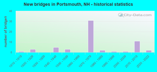
- New bridges - historical statistics
- 11910-1919
- 31920-1929
- 51940-1949
- 31950-1959
- 311970-1979
- 21980-1989
- 11990-1999
- 12000-2009
- 112010-2019
- 22020-2022
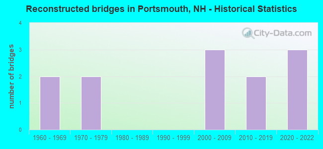
- Reconstructed bridges - Historical Statistics
- 21960-1969
- 21970-1979
- 01980-1989
- 01990-1999
- 32000-2009
- 22010-2019
- 32020-2022
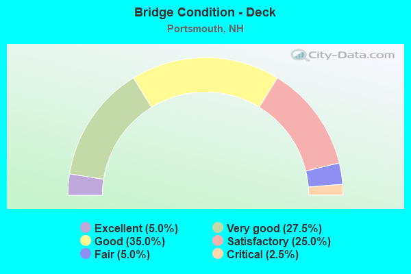
- Bridge Condition - Deck
- 5.0%Excellent
- 27.5%Very good
- 35.0%Good
- 25.0%Satisfactory
- 5.0%Fair
- 2.5%Critical
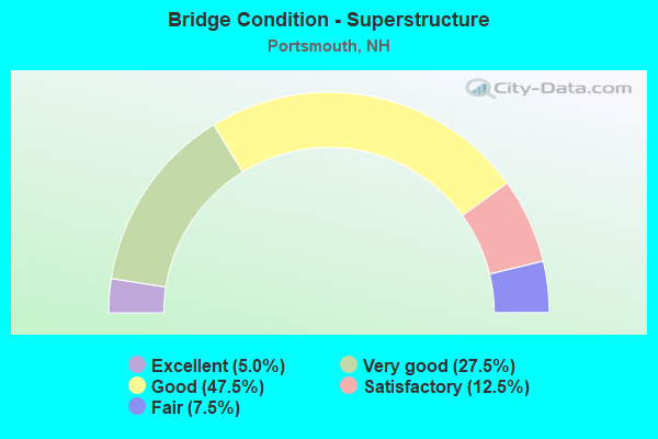
- Bridge Condition - Superstructure
- 5.0%Excellent
- 27.5%Very good
- 47.5%Good
- 12.5%Satisfactory
- 7.5%Fair
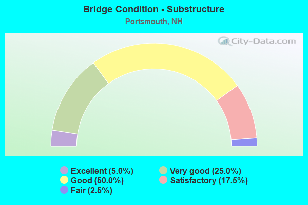
- Bridge Condition - Substructure
- 5.0%Excellent
- 25.0%Very good
- 50.0%Good
- 17.5%Satisfactory
- 2.5%Fair
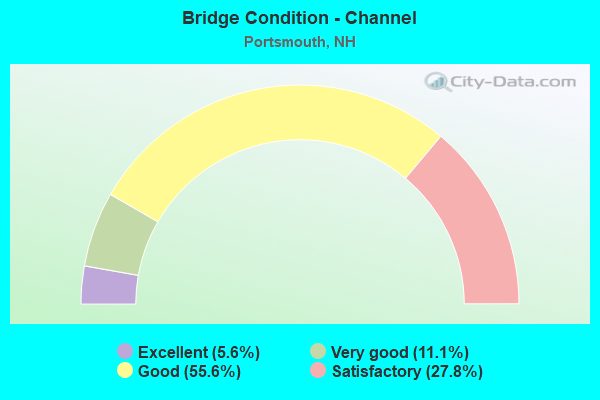
- Bridge Condition - Channel
- 5.6%Excellent
- 11.1%Very good
- 55.6%Good
- 27.8%Satisfactory
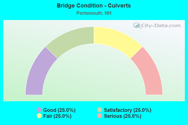
- Bridge Condition - Culverts
- 25.0%Good
- 25.0%Satisfactory
- 25.0%Fair
- 25.0%Serious
Find on map >> Show street view
Structure Number: 217024100069, Location: 200 FT FROM MECHANIC ST (Lat: 43.075297, Lng: -70.749481), Route carried "on" structure: City street , Year Built: 1958, Year Reconstructed: 1968, Status: Open, Structure Length: 8.56m (28.08ft), Average Daily Traffic: 912 (year 2020), Truck Traffic: 4%, Average Future Daily Traffic: 1,349 (year 2042), Design Load: HS 15, Features Intersected: LITTLE HARBOR, Facility Carried by Structure: PIERCES ISLAND RD
Minimum Vertical Clearance: 30+ m (98+ ft), Kilometerpoint: 0.092, Lanes on structure: 2, Owner: City or Municipal Highway Agency, Approaching Roadway Width: 7.3m (24.0ft), Material/Design: Steel, Design/Construction: Stringer/Multi-beam, Number Of Spans In Main Unit: 4, Length of Maximum Span: 20.7m (67.9ft), Curb or Sidewalk Widths: Left: 0.0m, Right: 1.5m (4.9ft), Curb-To-Curb Width: 7.3m (24.0ft), Out-to-Out Width: 9.8m (32.2ft)
Condition: Deck: Fair, Superstructure: Fair, Substructure: Satisfactory, Channel: Good, Operating Rating: 33.1 metric tons, Method Used To Determine Operating Rating: Load Factor (LF), Inventory Rating: 20.0 metric tons, Method Used To Determine Inventory Rating: Load Factor (LF), Structural Evaluation: Somewhat better than minimum adequacy, Deck Geometry: Meets minimum limits, Waterway Adequacy: Equal to present desirable criteria, Approach Roadway Alignment: Equal to present desirable criteria, Length Of Structure Improvement: 8.56m (28.08ft), Designated Inspection Frequency: Every 24 months, Underwater Inspection Frequency: Every 60 months, Inspection Date: October 2021, Underwater Inspection Date: July 2021, Bridge Improvement Cost: $2,718,000, Roadway Improvement Cost: $200,000, Total Project Cost: $3,142,000 ( Estimate for 2022), Deck Structure Type: Concrete Cast-file-Place, Wearing Surface/Protective System: Wearing Surface: Bituminous
Find on map >> Show street view
Structure Number: 217024100106, Location: .5 MI E JCT I-95 (Lat: 43.083128, Lng: -70.763458), Route carried "on" structure: State highway , Year Built: 1971, Status: Open, Structure Length: 4.27m (14.01ft), Average Daily Traffic: 7,936 (year 2020), Truck Traffic: 5%, Average Future Daily Traffic: 11,745 (year 2042), Design Load: HS 20+Mod, Features Intersected: TIDAL BASIN, Facility Carried by Structure: MARKET STREET WB
Minimum Vertical Clearance: 30+ m (98+ ft), Kilometerpoint: 0.872, Lanes on structure: 2, Base Highway Network: Yes, Owner: City or Municipal Highway Agency, Approaching Roadway Width: 9.4m (30.8ft), Skew: 23 degrees, Material/Design: Steel continuous, Design/Construction: Stringer/Multi-beam, Number Of Spans In Main Unit: 3, Length of Maximum Span: 15.8m (51.8ft), Curb or Sidewalk Widths: Left: 2.0m (6.6ft), Right: 0.2m (0.7ft), Curb-To-Curb Width: 9.4m (30.8ft), Out-to-Out Width: 14.5m (47.6ft)
Condition: Deck: Satisfactory, Superstructure: Satisfactory, Substructure: Good, Channel: Good, Operating Rating: 42.8 metric tons, Method Used To Determine Operating Rating: Load Factor (LF), Inventory Rating: 25.7 metric tons, Method Used To Determine Inventory Rating: Load Factor (LF), Structural Evaluation: Equal to present minimum criteria, Deck Geometry: Meets minimum limits, Waterway Adequacy: Equal to present desirable criteria, Approach Roadway Alignment: Equal to present desirable criteria, Length Of Structure Improvement: 4.27m (14.01ft), Designated Inspection Frequency: Every 24 months, Inspection Date: October 2021, Bridge Improvement Cost: $2,718,000, Roadway Improvement Cost: $200,000, Total Project Cost: $3,142,000 ( Estimate for 2022), Deck Structure Type: Concrete Cast-file-Place, Wearing Surface/Protective System: Wearing Surface: Bituminous, Membrane: Preformed Fabric
Find on map >> Show street view
Structure Number: 217024100108, Location: 0.1 FROM SARAH LONG BR. (Lat: 43.083461, Lng: -70.765714), Route carried "on" structure: Business Other road , Year Built: 1984, Year Reconstructed: 2019, Status: Open, Structure Length: 1.58m (5.18ft), Average Daily Traffic: 10 (year 2009), Truck Traffic: 5%, Average Future Daily Traffic: 14 (year 2042), Design Load: HS 25 or greater, Features Intersected: NORTH MILL POND, Facility Carried by Structure: SUBMARINE WAY
Minimum Vertical Clearance: 30+ m (98+ ft), Kilometerpoint: 0.027, Lanes on structure: 3, Owner: State Highway Agency, Approaching Roadway Width: 13.4m (44.0ft), Material/Design: Steel, Design/Construction: Stringer/Multi-beam, Number Of Spans In Main Unit: 1, Length of Maximum Span: 14.9m (48.9ft), Curb or Sidewalk Widths: Left: 1.8m (5.9ft), Right: 0.2m (0.7ft), Curb-To-Curb Width: 12.8m (42.0ft), Out-to-Out Width: 17.1m (56.1ft)
Condition: Deck: Satisfactory, Superstructure: Good, Substructure: Good, Channel: Excellent, Operating Rating: 47.4 metric tons, Method Used To Determine Operating Rating: Load Factor (LF), Inventory Rating: 28.4 metric tons, Method Used To Determine Inventory Rating: Load Factor (LF), Structural Evaluation: Better than present minimum criteria, Deck Geometry: Meets minimum limits, Waterway Adequacy: Superior to present desirable criteria, Approach Roadway Alignment: Superior to present desirable criteria, Length Of Structure Improvement: 1.58m (5.18ft), Designated Inspection Frequency: Every 24 months, Inspection Date: June 2021, Bridge Improvement Cost: $2,718,000, Roadway Improvement Cost: $200,000, Total Project Cost: $3,142,000 ( Estimate for 2022), Deck Structure Type: Concrete Cast-file-Place, Wearing Surface/Protective System: Wearing Surface: Monolithic Concrete
Find on map >> Show street view
Structure Number: 217024600083, Location: 0.1 MI SOUTH MAINE-NH SL (Lat: 43.078108, Lng: -70.753122), Route carried "on" structure: US 1, Year Built: 1921, Year Reconstructed: 2013, Status: Open, Structure Length: 4.06m (13.32ft), Average Daily Traffic: 12,566 (year 2020), Truck Traffic: 5%, Average Future Daily Traffic: 18,597 (year 2042), Design Load: HL 93, Features Intersected: DANIEL STREET
Minimum Vertical Clearance: 30+ m (98+ ft), Kilometerpoint: 26.841, Lanes on structure: 2, Lanes under structure: 2, Base Highway Network: Yes, Owner: City or Municipal Highway Agency, Approaching Roadway Width: 9.8m (32.2ft), Skew: 2 degrees, Material/Design: Steel continuous, Design/Construction: Stringer/Multi-beam, Number Of Spans In Main Unit: 2, Length of Maximum Span: 21.3m (69.9ft), Curb or Sidewalk Widths: Left: 1.8m (5.9ft), Right: 1.8m (5.9ft), Curb-To-Curb Width: 9.8m (32.2ft), Out-to-Out Width: 14.2m (46.6ft)
Condition: Deck: Very good, Superstructure: Very good, Substructure: Very good, Operating Rating: 53.8 metric tons, Method Used To Determine Operating Rating: Load and Resistance Factor (LRFR), Inventory Rating: 41.5 metric tons, Method Used To Determine Inventory Rating: Load and Resistance Factor (LRFR), Structural Evaluation: Equal to present desirable criteria, Deck Geometry: Meets minimum limits, Underclear: High priority of replacement, Approach Roadway Alignment: Meets minimum limits, Length Of Structure Improvement: 4.06m (13.32ft), Designated Inspection Frequency: Every 24 months, Inspection Date: October 2021, Bridge Improvement Cost: $2,718,000, Roadway Improvement Cost: $200,000, Total Project Cost: $3,142,000 ( Estimate for 2022), Deck Structure Type: Concrete Cast-file-Place, Wearing Surface/Protective System: Wearing Surface: Bituminous, Membrane: Preformed Fabric, Deck Protection: Epoxy Coated Reinforcing
Find on map >> Show street view
Structure Number: 217024700084, Location: NH-MAINE SL (Lat: 43.079611, Lng: -70.752553), Route carried "on" structure: US 1, Year Built: 1921, Year Reconstructed: 2013, Status: Open, Structure Length: 27.51m (90.26ft), Average Daily Traffic: 8,377 (year 2020), Truck Traffic: 5%, Average Future Daily Traffic: 12,397 (year 2042), Design Load: HL 93, Features Intersected: PISCATAQUA RIVER
Minimum Vertical Clearance: 5.49m (18.01ft), Kilometerpoint: 26.998, Lanes on structure: 2, Base Highway Network: Yes, Owner: State Highway Agency, Approaching Roadway Width: 9.8m (32.2ft), Navigation Control: Yes ( Vertical Clearance: 45.7m (149.9ft), Horizontal Clearance: 80.5m (264.1ft)), Material/Design: Steel, Design/Construction: Movable - Lift, Number Of Spans In Main Unit: 3, Length of Maximum Span: 90.5m (296.9ft), Curb or Sidewalk Widths: Left: 1.8m (5.9ft), Right: 1.8m (5.9ft), Curb-To-Curb Width: 9.8m (32.2ft), Out-to-Out Width: 14.1m (46.3ft)
Condition: Deck: Very good, Superstructure: Very good, Substructure: Very good, Channel: Satisfactory, Operating Rating: 49.2 metric tons, Method Used To Determine Operating Rating: Load and Resistance Factor (LRFR), Inventory Rating: 37.9 metric tons, Method Used To Determine Inventory Rating: Load and Resistance Factor (LRFR), Structural Evaluation: Equal to present desirable criteria, Deck Geometry: Meets minimum limits, Waterway Adequacy: Superior to present desirable criteria, Approach Roadway Alignment: Better than present minimum criteria, Length Of Structure Improvement: 27.51m (90.26ft), Designated Inspection Frequency: Every 24 months, Critical Feature Inspection Frequency: Every 24 months, Underwater Inspection Frequency: Every 60 months, Inspection Date: September 2021, Critical Feature Inspection Date: September 2021, Underwater Inspection Date: September 2008, Bridge Improvement Cost: $2,718,000, Roadway Improvement Cost: $200,000, Total Project Cost: $3,142,000 ( Estimate for 2022), Deck Structure Type: Concrete Cast-file-Place, Wearing Surface/Protective System: Wearing Surface: Bituminous, Membrane: Preformed Fabric, Deck Protection: Epoxy Coated Reinforcing
Find on map >> Show street view
Structure Number: 21702500011, Location: MAINE STATELINE (Lat: 43.086617, Lng: -70.761139), Route carried "on" structure: US 1BYP, Year Built: 2017, Status: Open, Structure Length: 84.86m (278.41ft), Average Daily Traffic: 10,398 (year 2020), Truck Traffic: 5%, Average Future Daily Traffic: 15,389 (year 2042), Design Load: HL 93, Features Intersected: PISCATAQUA RIVER,RR, Facility Carried by Structure: US 1 BYPASS
Minimum Vertical Clearance: 30+ m (98+ ft), Kilometerpoint: 4.096, Lanes on structure: 2, Lanes under structure: 4, Base Highway Network: Yes, Owner: Local Toll Authority, Approaching Roadway Width: 10.1m (33.1ft), Navigation Control: Yes ( Vertical Clearance: 41.1m (134.8ft), Horizontal Clearance: 76.2m (250.0ft)), Material/Design: Steel, Design/Construction: Movable - Lift, Number Of Spans In Main Unit: 1, Number Of Approach Spans: 10, Length of Maximum Span: 102.1m (335.0ft), Curb or Sidewalk Widths: Left: 0.2m (0.7ft), Right: 0.2m (0.7ft), Curb-To-Curb Width: 10.1m (33.1ft), Out-to-Out Width: 11.3m (37.1ft)
Condition: Deck: Very good, Superstructure: Very good, Substructure: Very good, Channel: Very good, Operating Rating: 49.0 metric tons, Method Used To Determine Operating Rating: Load and Resistance Factor (LRFR), Inventory Rating: 37.8 metric tons, Method Used To Determine Inventory Rating: Load and Resistance Factor (LRFR), Structural Evaluation: Equal to present desirable criteria, Deck Geometry: Meets minimum limits, Underclear: Somewhat better than minimum adequacy, Waterway Adequacy: Superior to present desirable criteria, Approach Roadway Alignment: Equal to present desirable criteria, Length Of Structure Improvement: 84.86m (278.41ft), Designated Inspection Frequency: Every 24 months, Critical Feature Inspection Frequency: Every 24 months, Underwater Inspection Frequency: Every 60 months, Inspection Date: October 2021, Critical Feature Inspection Date: October 2021, Underwater Inspection Date: May 2020, Bridge Improvement Cost: $2,718,000, Roadway Improvement Cost: $200,000, Total Project Cost: $3,142,000 ( Estimate for 2022), Deck Structure Type: Concrete Cast-file-Place, Wearing Surface/Protective System: Wearing Surface: Monolithic Concrete, Deck Protection: Epoxy Coated Reinforcing
Find on map >> Show street view
Structure Number: 217025700127, Location: Approach to High Level Br (Lat: 43.089706, Lng: -70.771006), Route carried "on" structure: Interstate 95, Year Built: 1971, Status: Open, Structure Length: 55.17m (181.00ft), Average Daily Traffic: 69,967 (year 2020), Truck Traffic: 6%, Average Future Daily Traffic: 103,551 (year 2042), Design Load: HS 20+Mod, Features Intersected: PREBLE WAY,PAR
Minimum Vertical Clearance: 30+ m (98+ ft), Kilometerpoint: 25.465, Lanes on structure: 6, Lanes under structure: 4, Base Highway Network: Yes, Owner: State Toll Authority, Approaching Roadway Width: 30.5m (100.1ft), Skew: 30 degrees, Material/Design: Steel continuous, Design/Construction: Stringer/Multi-beam, Number Of Spans In Main Unit: 19, Length of Maximum Span: 34.1m (111.9ft), Curb or Sidewalk Widths: Left: 0.2m (0.7ft), Right: 0.2m (0.7ft), Curb-To-Curb Width: 29.9m (98.1ft), Out-to-Out Width: 31.9m (104.7ft)
Condition: Deck: Satisfactory, Superstructure: Good, Substructure: Good, Operating Rating: 59.0 metric tons, Method Used To Determine Operating Rating: Load Factor (LF), Inventory Rating: 35.3 metric tons, Method Used To Determine Inventory Rating: Load Factor (LF), Structural Evaluation: Better than present minimum criteria, Deck Geometry: Superior to present desirable criteria, Underclear: Superior to present desirable criteria, Approach Roadway Alignment: Equal to present desirable criteria, Length Of Structure Improvement: 55.17m (181.00ft), Designated Inspection Frequency: Every 24 months, Inspection Date: June 2021, Bridge Improvement Cost: $2,718,000, Roadway Improvement Cost: $200,000, Total Project Cost: $3,142,000 ( Estimate for 2022), Deck Structure Type: Concrete Cast-file-Place, Wearing Surface/Protective System: Wearing Surface: Bituminous, Membrane: Other
Find on map >> Show street view
Structure Number: 217025800128, Location: I-95 AT MAINE STATE LINE (Lat: 43.092536, Lng: -70.766983), Route carried "on" structure: Interstate 95, Year Built: 1971, Status: Open, Structure Length: 40.97m (134.42ft), Average Daily Traffic: 69,967 (year 2020), Truck Traffic: 6%, Average Future Daily Traffic: 103,551 (year 2042), Design Load: HS 20+Mod, Features Intersected: PISCATAQUA RIVER
Minimum Vertical Clearance: 5.23m (17.16ft), Kilometerpoint: 25.880, Lanes on structure: 6, Base Highway Network: Yes, Owner: State Toll Authority, Approaching Roadway Width: 30.5m (100.1ft), Skew: 30 degrees, Navigation Control: Yes ( Vertical Clearance: 41.1m (134.8ft), Horizontal Clearance: 134.1m (440.0ft)), Material/Design: Steel continuous, Design/Construction: Truss - Thru, Number Of Spans In Main Unit: 3, Length of Maximum Span: 230.4m (755.9ft), Curb or Sidewalk Widths: Left: 0.2m (0.7ft), Right: 0.2m (0.7ft), Curb-To-Curb Width: 29.9m (98.1ft), Out-to-Out Width: 31.9m (104.7ft)
Condition: Deck: Satisfactory, Superstructure: Satisfactory, Substructure: Satisfactory, Channel: Satisfactory, Operating Rating: 55.7 metric tons, Method Used To Determine Operating Rating: Load Factor (LF), Inventory Rating: 33.4 metric tons, Method Used To Determine Inventory Rating: Load Factor (LF), Structural Evaluation: Equal to present minimum criteria, Deck Geometry: Superior to present desirable criteria, Waterway Adequacy: Superior to present desirable criteria, Approach Roadway Alignment: Equal to present desirable criteria, Length Of Structure Improvement: 40.97m (134.42ft), Designated Inspection Frequency: Every 24 months, Critical Feature Inspection Frequency: Every 24 months, Inspection Date: December 2020, Critical Feature Inspection Date: December 2020, Bridge Improvement Cost: $2,718,000, Roadway Improvement Cost: $200,000, Total Project Cost: $3,142,000 ( Estimate for 2022), Deck Structure Type: Concrete Cast-file-Place, Wearing Surface/Protective System: Wearing Surface: Bituminous, Membrane: Other
Find on map >> Show street view
Structure Number: 217013600127, Location: 3.0MI S OF MAINE S/L (Lat: 43.058031, Lng: -70.804217), Route carried "under" structure: Interstate 95, Year Built: 1971, Structure Length: 0. m, Average Daily Traffic: 97,000 (year 2012), Truck Traffic: 6%, Features Intersected: I-95, Facility Carried by Structure: NH 33
Minimum Vertical Clearance: 4.98m (16.34ft), Kilometerpoint: 0.000, Lanes on structure: 4, Lanes under structure: 8, Material/Design: Steel continuous, Design/Construction: Stringer/Multi-beam, Length of Maximum Span: 43.9m (144.0ft)
Find on map >> Show street view
Structure Number: 217014400125, Location: 2.8MI S OF MAINE S/L (Lat: 43.060233, Lng: -70.800889), Route carried "under" structure: Interstate 95, Year Built: 1971, Structure Length: 0. m, Average Daily Traffic: 69,000 (year 2015), Truck Traffic: 6%, Features Intersected: I-95, Facility Carried by Structure: SHERBURNE ROAD
Minimum Vertical Clearance: 5.63m (18.47ft), Kilometerpoint: 0.000, Lanes on structure: 2, Lanes under structure: 8, Material/Design: Steel continuous, Design/Construction: Stringer/Multi-beam, Length of Maximum Span: 38.1m (125.0ft)
Find on map >> Show street view
Structure Number: 217018000122, Location: SP TPK,I-95 INTERCHANGE (Lat: 43.069625, Lng: -70.787756), Route carried "under" structure: Ramp Interstate 95, Year Built: 1972, Structure Length: 0. m, Average Daily Traffic: 9,000 (year 1984), Truck Traffic: 6%, Features Intersected: I-95 NB RAMP
Minimum Vertical Clearance: 4.93m (16.17ft), Kilometerpoint: 0.000, Lanes on structure: 2, Lanes under structure: 2, Material/Design: Steel, Design/Construction: Stringer/Multi-beam, Length of Maximum Span: 34.7m (113.8ft)
Find on map >> Show street view
Structure Number: 217018300087, Location: 0.6MI FROM JCT RT 1 (Lat: 43.061814, Lng: -70.774239), Route carried "under" structure: Bypass US 1, Year Built: 2013, Structure Length: 0. m, Average Daily Traffic: 11,000 (year 2013), Truck Traffic: 8%, Features Intersected: US 1 BYPASS, Facility Carried by Structure: NH 33
Minimum Vertical Clearance: 4.70m (15.42ft), Kilometerpoint: 0.000, Lanes on structure: 2, Lanes under structure: 4, Material/Design: Steel continuous, Design/Construction: Stringer/Multi-beam, Length of Maximum Span: 20.4m (66.9ft)
Find on map >> Show street view
Structure Number: 217018300121, Location: SP TPK,I-95 INTERCHANGE (Lat: 43.070017, Lng: -70.786772), Route carried "under" structure: Interstate 95, Year Built: 1972, Structure Length: 0. m, Average Daily Traffic: 89,900 (year 2009), Truck Traffic: 6%, Features Intersected: I-95 NB
Minimum Vertical Clearance: 4.95m (16.24ft), Kilometerpoint: 0.000, Lanes on structure: 2, Lanes under structure: 3, Material/Design: Steel, Design/Construction: Stringer/Multi-beam, Length of Maximum Span: 46.9m (153.9ft)
Find on map >> Show street view
Structure Number: 217018400124, Location: SP TPK,I-95 INTERCHANGE (Lat: 43.070769, Lng: -70.787419), Route carried "under" structure: Ramp Interstate 95, Year Built: 1972, Structure Length: 0. m, Average Daily Traffic: 9,000 (year 1984), Truck Traffic: 4%, Features Intersected: NB RAMP
Minimum Vertical Clearance: 4.93m (16.17ft), Kilometerpoint: 0.000, Lanes on structure: 3, Lanes under structure: 2, Material/Design: Steel, Design/Construction: Stringer/Multi-beam, Length of Maximum Span: 38.1m (125.0ft)
Find on map >> Show street view
Structure Number: 217018800097, Location: 1.0 MI FROM JCT US 1 (Lat: 43.065828, Lng: -70.776469), Route carried "under" structure: Bypass US 1, Year Built: 2015, Structure Length: 0. m, Average Daily Traffic: 21,000 (year 2015), Truck Traffic: 8%, Features Intersected: US 1 BYPASS, Facility Carried by Structure: ISLINGTON STREET
Minimum Vertical Clearance: 4.73m (15.52ft), Kilometerpoint: 0.000, Lanes on structure: 2, Lanes under structure: 4, Material/Design: Steel continuous, Design/Construction: Stringer/Multi-beam, Length of Maximum Span: 20.4m (66.9ft)
Find on map >> Show street view
Structure Number: 217019100131, Location: AUX. ENTRANCE TO PAFB (Lat: 43.074714, Lng: -70.788086), Route carried "under" structure: Ramp Interstate 95, Year Built: 1972, Structure Length: 0. m, Average Daily Traffic: 20,000 (year 1984), Truck Traffic: 6%, Features Intersected: I-95 RAMPS, Facility Carried by Structure: ASHLAND ROAD
Minimum Vertical Clearance: 4.96m (16.27ft), Kilometerpoint: 0.000, Lanes on structure: 2, Lanes under structure: 4, Material/Design: Steel continuous, Design/Construction: Stringer/Multi-beam, Length of Maximum Span: 30.8m (101.0ft)
Find on map >> Show street view
Structure Number: 217019700122, Location: I-95,SP TPK INTERCHANGE (Lat: 43.074214, Lng: -70.782461), Route carried "under" structure: US 4, Year Built: 1971, Structure Length: 0. m, Average Daily Traffic: 31,000 (year 2013), Truck Traffic: 8%, Features Intersected: US 4,NH 16,SP TPK, Facility Carried by Structure: I-95 NB
Minimum Vertical Clearance: 4.93m (16.17ft), Kilometerpoint: 0.000, Lanes on structure: 3, Lanes under structure: 4, Material/Design: Steel, Design/Construction: Stringer/Multi-beam, Length of Maximum Span: 37.2m (122.0ft)
Find on map >> Show street view
Structure Number: 217019800123, Location: I-95,SP TPK INTERCHANGE (Lat: 43.074450, Lng: -70.782733), Route carried "under" structure: US 4, Year Built: 1970, Structure Length: 0. m, Average Daily Traffic: 31,000 (year 2013), Truck Traffic: 8%, Features Intersected: US 4,NH 16,SP TPK, Facility Carried by Structure: I-95 SB
Minimum Vertical Clearance: 4.96m (16.27ft), Kilometerpoint: 0.000, Lanes on structure: 3, Lanes under structure: 4, Material/Design: Steel, Design/Construction: Stringer/Multi-beam, Length of Maximum Span: 37.2m (122.0ft)
Find on map >> Show street view
Structure Number: 217019900139, Location: N SP TPK I-95 INTERCHANGE (Lat: 43.078967, Lng: -70.789125), Route carried "under" structure: Ramp Interstate 95, Year Built: 1971, Structure Length: 0. m, Average Daily Traffic: 14,000 (year 2002), Truck Traffic: 8%, Features Intersected: NB RAMP, Facility Carried by Structure: US 4,NH 16,SP TPK
Minimum Vertical Clearance: 4.97m (16.31ft), Kilometerpoint: 0.000, Lanes on structure: 2, Lanes under structure: 2, Material/Design: Steel, Design/Construction: Stringer/Multi-beam, Length of Maximum Span: 42.7m (140.1ft)
Find on map >> Show street view
Structure Number: 217020500116, Location: 0.6 MI FROM MAINE SL (Lat: 43.074700, Lng: -70.778303), Route carried "under" structure: Bypass US 1, Year Built: 2020, Structure Length: 0. m, Average Daily Traffic: 11,000 (year 2015), Truck Traffic: 8%, Features Intersected: US 1 BYPASS, Facility Carried by Structure: WOODBURY AVENUE
Minimum Vertical Clearance: 4.70m (15.42ft), Kilometerpoint: 0.000, Lanes on structure: 2, Lanes under structure: 4, Material/Design: Steel continuous, Design/Construction: Stringer/Multi-beam, Length of Maximum Span: 16.8m (55.1ft)
Find on map >> Show street view
Structure Number: 217021100114, Location: 0.2 MI FROM JCT NH 16 (Lat: 43.076400, Lng: -70.775831), Route carried "under" structure: Bypass US 1, Year Built: 2019, Structure Length: 0. m, Average Daily Traffic: 14,000 (year 2012), Truck Traffic: 8%, Features Intersected: US 1 BYPASS, Facility Carried by Structure: STARK STREET
Minimum Vertical Clearance: 4.88m (16.01ft), Kilometerpoint: 0.000, Lanes on structure: 2, Lanes under structure: 4, Material/Design: Steel continuous, Design/Construction: Stringer/Multi-beam, Length of Maximum Span: 16.8m (55.1ft)
Find on map >> Show street view
Structure Number: 217022200121, Location: .6 MI FROM JCT NH 16 (Lat: 43.081128, Lng: -70.774847), Route carried "under" structure: City street , Year Built: 1970, Structure Length: 0. m, Average Daily Traffic: 1,300 (year 2014), Truck Traffic: 3%, Features Intersected: MAPLEWOOD AVENUE, Facility Carried by Structure: I-95
Minimum Vertical Clearance: 4.44m (14.57ft), Kilometerpoint: 0.000, Lanes on structure: 8, Lanes under structure: 2, Material/Design: Concrete, Design/Construction: Frame, Length of Maximum Span: 19.5m (64.0ft)
Find on map >> Show street view
Structure Number: 217022700112, Location: .8 MI FROM JCT NH 16 (Lat: 43.080611, Lng: -70.769647), Route carried "under" structure: Bypass US 1, Year Built: 2015, Structure Length: 0. m, Average Daily Traffic: 14,000 (year 2012), Truck Traffic: 8%, Features Intersected: US 1 BYPASS, Facility Carried by Structure: MAPLEWOOD AVENUE
Minimum Vertical Clearance: 4.80m (15.75ft), Kilometerpoint: 0.000, Lanes on structure: 2, Lanes under structure: 3, Material/Design: Steel continuous, Design/Construction: Stringer/Multi-beam, Length of Maximum Span: 19.8m (65.0ft)
Find on map >> Show street view
Structure Number: 217024600083, Location: 0.1 MI SOUTH MAINE-NH SL (Lat: 43.078108, Lng: -70.753122), Route carried "under" structure: City street , Year Built: 1921, Structure Length: 0. m, Average Daily Traffic: 4,400 (year 2009), Truck Traffic: 5%, Features Intersected: DANIEL STREET, Facility Carried by Structure: US 1,SCOTT AVENUE
Minimum Vertical Clearance: 4.03m (13.22ft), Kilometerpoint: 0.000, Lanes on structure: 2, Lanes under structure: 2, Material/Design: Steel continuous, Design/Construction: Stringer/Multi-beam, Length of Maximum Span: 21.3m (69.9ft)