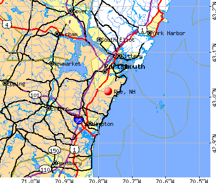
Rye, New Hampshire
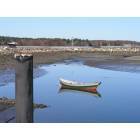
Rye: Rye Harbor Skif
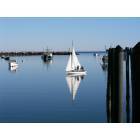
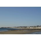
Rye: Rye Harbor New Hampshire Photos
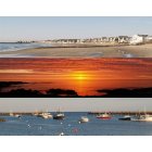
Rye: Jenness Beach Late Afternoon Rye, NH
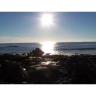
Rye: Morning has broken
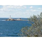
Rye: White Island Lighthouse from Star Island
Rye: Rye Water Views
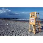
Rye: Wallis Sands Public Beach

Rye: Jenness Beach Late Afternoon Rye, NH
- add
your
Submit your own pictures of this town and show them to the world
- OSM Map
- General Map
- Google Map
- MSN Map
Population change since 2000: +2.2%
 |
| Males: 2,583 | |
| Females: 2,715 |
| Median resident age: | 48.8 years |
| New Hampshire median age: | 43.9 years |
Zip codes: 03870.
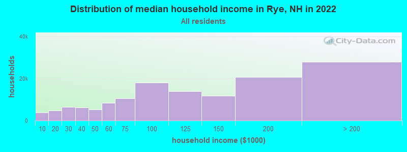
| Rye: | $116,684 |
| NH: | $89,992 |
Estimated per capita income in 2022: $80,662 (it was $36,746 in 2000)
Rye town income, earnings, and wages data
Estimated median house or condo value in 2022: $958,539 (it was $313,700 in 2000)
| Rye: | $958,539 |
| NH: | $384,700 |
Mean prices in 2022: all housing units: $614,227; detached houses: $665,470; townhouses or other attached units: $408,866; in 2-unit structures: $730,084; in 3-to-4-unit structures: over $1,000,000; in 5-or-more-unit structures: $329,099; mobile homes: $126,160
Detailed information about poverty and poor residents in Rye, NH


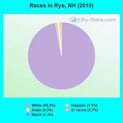
- 5,13196.8%White alone
- 581.1%Hispanic
- 470.9%Asian alone
- 390.7%Two or more races
- 150.3%Black alone
- 50.09%Other race alone
- 20.04%Native Hawaiian and Other
Pacific Islander alone - 10.02%American Indian alone
Races in Rye detailed stats: ancestries, foreign born residents, place of birth
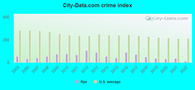
Type |
2009 |
2010 |
2011 |
2012 |
2013 |
2014 |
2015 |
2016 |
2017 |
2018 |
2019 |
2020 |
2021 |
2022 |
|---|---|---|---|---|---|---|---|---|---|---|---|---|---|---|
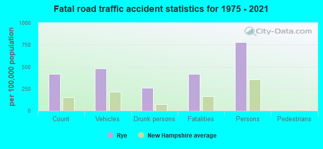
| Murders (per 100,000) | 0 (0.0) | 0 (0.0) | 0 (0.0) | 0 (0.0) | 0 (0.0) | 0 (0.0) | 0 (0.0) | 0 (0.0) | 0 (0.0) | 0 (0.0) | 0 (0.0) | 0 (0.0) | 0 (0.0) | 0 (0.0) |
| Rapes (per 100,000) | 0 (0.0) | 0 (0.0) | 0 (0.0) | 2 (37.6) | 3 (56.6) | 0 (0.0) | 0 (0.0) | 3 (55.6) | 2 (36.9) | 1 (18.2) | 0 (0.0) | 1 (18.2) | 1 (18.0) | 0 (0.0) |
| Robberies (per 100,000) | 0 (0.0) | 0 (0.0) | 0 (0.0) | 0 (0.0) | 0 (0.0) | 0 (0.0) | 0 (0.0) | 0 (0.0) | 0 (0.0) | 0 (0.0) | 0 (0.0) | 0 (0.0) | 0 (0.0) | 0 (0.0) |
| Assaults (per 100,000) | 5 (97.3) | 4 (75.5) | 3 (56.6) | 1 (18.8) | 0 (0.0) | 2 (37.4) | 1 (18.7) | 1 (18.5) | 2 (36.9) | 4 (72.7) | 0 (0.0) | 0 (0.0) | 1 (18.0) | 0 (0.0) |
| Burglaries (per 100,000) | 3 (58.4) | 3 (56.6) | 4 (75.4) | 2 (37.6) | 4 (75.5) | 7 (131.0) | 3 (56.2) | 7 (129.7) | 0 (0.0) | 1 (18.2) | 2 (36.6) | 1 (18.2) | 1 (18.0) | 1 (18.0) |
| Thefts (per 100,000) | 63 (1,226) | 76 (1,435) | 69 (1,301) | 86 (1,615) | 53 (1,001) | 51 (954.3) | 45 (843.2) | 40 (741.3) | 44 (811.1) | 25 (454.5) | 35 (640.6) | 22 (400.4) | 20 (359.3) | 13 (234.2) |
| Auto thefts (per 100,000) | 1 (19.5) | 0 (0.0) | 0 (0.0) | 4 (75.1) | 0 (0.0) | 0 (0.0) | 1 (18.7) | 2 (37.1) | 1 (18.4) | 1 (18.2) | 5 (91.5) | 0 (0.0) | 2 (35.9) | 1 (18.0) |
| Arson (per 100,000) | 0 (0.0) | 0 (0.0) | 0 (0.0) | 0 (0.0) | 0 (0.0) | 1 (18.7) | 0 (0.0) | 2 (37.1) | 1 (18.4) | 0 (0.0) | 0 (0.0) | 0 (0.0) | 0 (0.0) | 0 (0.0) |
| City-Data.com crime index | 74.1 | 76.4 | 68.6 | 107.0 | 90.6 | 54.8 | 42.9 | 89.9 | 70.8 | 50.0 | 35.5 | 31.8 | 36.5 | 12.1 |
The City-Data.com crime index weighs serious crimes and violent crimes more heavily. Higher means more crime, U.S. average is 246.1. It adjusts for the number of visitors and daily workers commuting into cities.
Crime rate in Rye detailed stats: murders, rapes, robberies, assaults, burglaries, thefts, arson
Full-time law enforcement employees in 2021, including police officers: 11 (10 officers - 10 male; 0 female).
| Officers per 1,000 residents here: | 1.80 |
| New Hampshire average: | 2.14 |
 Recent articles from our blog. Our writers, many of them Ph.D. graduates or candidates, create easy-to-read articles on a wide variety of topics.

 | Bear sighting in Rye; residents urged to remove food sources (3 replies) |
| Planning a trip to NH (2 replies) |
| Moving to southeast NH help!!! (48 replies) |
| Best safe towns for commute to Portsmouth NH (34 replies) |
| Neighborhood Help ... Near Portsmouth (6 replies) |
| First visit to NH (28 replies) |
Latest news from Rye, NH collected exclusively by city-data.com from local newspapers, TV, and radio stations
Ancestries: English (21.4%), Irish (18.4%), Italian (11.8%), German (11.5%), French (7.8%), United States (6.0%).
Current Local Time: EST time zone
Incorporated in 1726
Elevation: 57 feet
Land area: 12.6 square miles.
Population density: 420 people per square mile (low).
221 residents are foreign born (1.9% Europe, 1.5% North America, 0.8% Asia).
| This town: | 4.3% |
| New Hampshire: | 4.4% |
| Rye town: | 1.2% ($3,879) |
| New Hampshire: | 2.3% ($2,946) |
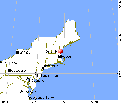
Nearest city with pop. 50,000+: Haverhill, MA  (22.6 miles , pop. 58,969).
Nearest city with pop. 200,000+: Boston, MA (49.9 miles , pop. 589,141).
Nearest city with pop. 1,000,000+: Bronx, NY (218.8 miles , pop. 1,332,650).
Nearest cities:
), )Latitude: 43.00 N, Longitude: 70.76 W
Area code commonly used in this area: 603

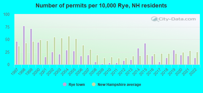
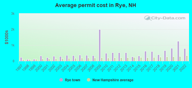
Single-family new house construction building permits:
- 2022: 7 buildings, average cost: $791,200
- 2021: 9 buildings, average cost: $1,267,400
- 2020: 10 buildings, average cost: $818,300
- 2019: 15 buildings, average cost: $663,700
- 2018: 7 buildings, average cost: $408,000
- 2017: 3 buildings, average cost: $609,000
- 2016: 9 buildings, average cost: $628,900
- 2015: 22 buildings, average cost: $330,200
- 2014: 17 buildings, average cost: $280,700
- 2013: 5 buildings, average cost: $533,500
- 2012: 4 buildings, average cost: $533,500
- 2011: 2 buildings, average cost: $543,800
- 2010: 2 buildings, average cost: $502,700
- 2009: 1 building, cost: $2,000,000
- 2008: 3 buildings, average cost: $355,400
- 2007: 10 buildings, average cost: $375,800
- 2006: 9 buildings, average cost: $380,300
- 2005: 14 buildings, average cost: $357,800
- 2004: 15 buildings, average cost: $367,900
- 2003: 11 buildings, average cost: $296,900
- 2002: 13 buildings, average cost: $314,700
- 2001: 8 buildings, average cost: $216,900
- 2000: 23 buildings, average cost: $341,600
- 1999: 37 buildings, average cost: $131,800
- 1998: 40 buildings, average cost: $117,000
- 1997: 24 buildings, average cost: $242,200
| Here: | 1.9% |
| New Hampshire: | 2.5% |
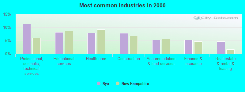
- Professional, scientific, technical services (11.3%)
- Educational services (8.1%)
- Health care (7.9%)
- Construction (7.8%)
- Accommodation & food services (5.2%)
- Finance & insurance (5.2%)
- Real estate & rental & leasing (4.6%)
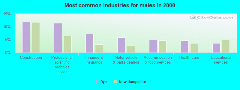
- Construction (11.8%)
- Professional, scientific, technical services (11.4%)
- Finance & insurance (7.2%)
- Motor vehicle & parts dealers (5.8%)
- Accommodation & food services (4.8%)
- Health care (4.6%)
- Educational services (3.6%)
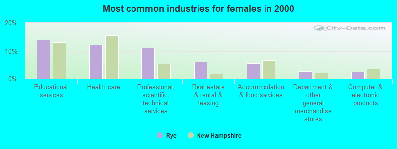
- Educational services (14.0%)
- Health care (12.3%)
- Professional, scientific, technical services (11.1%)
- Real estate & rental & leasing (6.2%)
- Accommodation & food services (5.8%)
- Department & other general merchandise stores (2.8%)
- Computer & electronic products (2.7%)
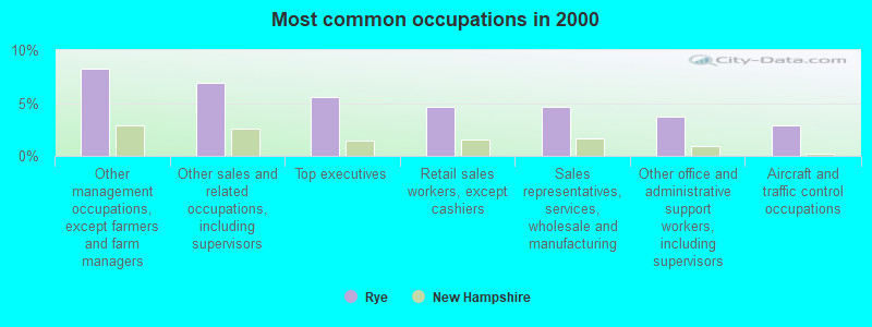
- Other management occupations, except farmers and farm managers (8.3%)
- Other sales and related occupations, including supervisors (6.9%)
- Top executives (5.5%)
- Retail sales workers, except cashiers (4.6%)
- Sales representatives, services, wholesale and manufacturing (4.6%)
- Other office and administrative support workers, including supervisors (3.7%)
- Aircraft and traffic control occupations (2.9%)

- Other management occupations, except farmers and farm managers (11.2%)
- Top executives (7.7%)
- Sales representatives, services, wholesale and manufacturing (6.2%)
- Other sales and related occupations, including supervisors (5.9%)
- Retail sales workers, except cashiers (5.3%)
- Aircraft and traffic control occupations (4.0%)
- Computer specialists (3.8%)
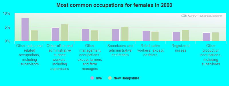
- Other sales and related occupations, including supervisors (8.3%)
- Other office and administrative support workers, including supervisors (4.9%)
- Other management occupations, except farmers and farm managers (4.4%)
- Secretaries and administrative assistants (4.3%)
- Retail sales workers, except cashiers (3.7%)
- Registered nurses (3.3%)
- Other production occupations, including supervisors (3.1%)
Average climate in Rye, New Hampshire
Based on data reported by over 4,000 weather stations


(lower is better)
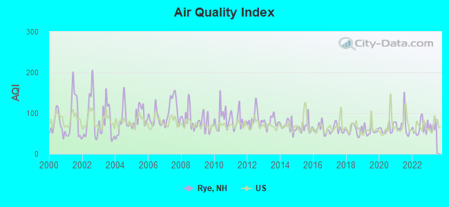
Air Quality Index (AQI) level in 2022 was 64.4. This is about average.
| City: | 64.4 |
| U.S.: | 72.6 |
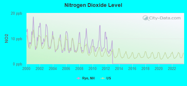
Nitrogen Dioxide (NO2) [ppb] level in 2012 was 6.65. This is worse than average. Closest monitor was 4.7 miles away from the city center.
| City: | 6.65 |
| U.S.: | 5.11 |
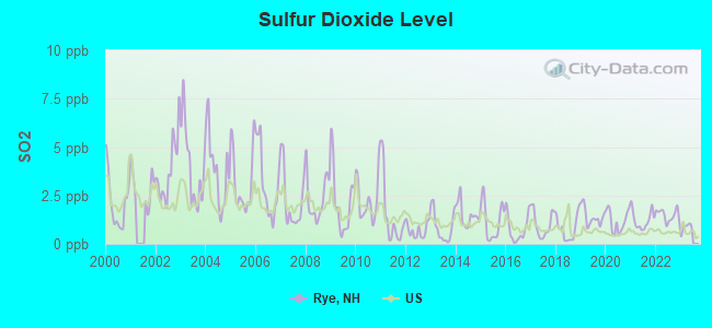
Sulfur Dioxide (SO2) [ppb] level in 2022 was 1.48. This is about average. Closest monitor was 4.7 miles away from the city center.
| City: | 1.48 |
| U.S.: | 1.51 |
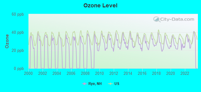
Ozone [ppb] level in 2022 was 29.7. This is about average. Closest monitor was 0.6 miles away from the city center.
| City: | 29.7 |
| U.S.: | 33.3 |
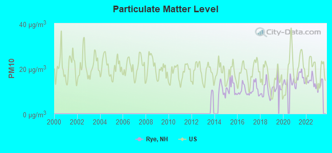
Particulate Matter (PM10) [µg/m3] level in 2022 was 14.4. This is better than average. Closest monitor was 5.2 miles away from the city center.
| City: | 14.4 |
| U.S.: | 19.2 |
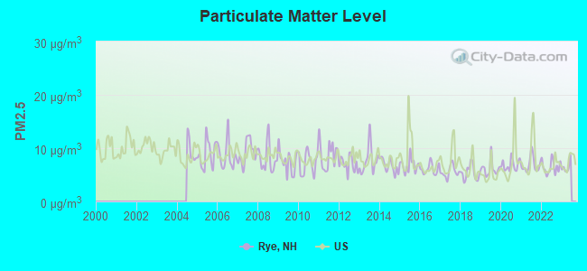
Particulate Matter (PM2.5) [µg/m3] level in 2022 was 6.43. This is better than average. Closest monitor was 5.2 miles away from the city center.
| City: | 6.43 |
| U.S.: | 8.11 |
Tornado activity:
Rye-area historical tornado activity is near New Hampshire state average. It is 57% smaller than the overall U.S. average.
On 6/9/1953, a category F3 (max. wind speeds 158-206 mph) tornado 11.0 miles away from the Rye town center injured 5 people and caused between $5000 and $50,000 in damages.
On 9/29/1974, a category F3 tornado 34.6 miles away from the town center injured one person and caused between $50,000 and $500,000 in damages.
Earthquake activity:
Rye-area historical earthquake activity is significantly above New Hampshire state average. It is 73% smaller than the overall U.S. average.On 10/16/2012 at 23:12:25, a magnitude 4.7 (4.7 ML, Depth: 10.0 mi, Class: Light, Intensity: IV - V) earthquake occurred 41.6 miles away from the city center
On 4/20/2002 at 10:50:47, a magnitude 5.3 (5.3 ML, Depth: 3.0 mi, Class: Moderate, Intensity: VI - VII) earthquake occurred 180.3 miles away from Rye center
On 1/19/1982 at 00:14:42, a magnitude 4.7 (4.5 MB, 4.7 MD, 4.5 LG) earthquake occurred 54.8 miles away from the city center
On 10/7/1983 at 10:18:46, a magnitude 5.3 (5.1 MB, 5.3 LG, 5.1 ML) earthquake occurred 191.6 miles away from the city center
On 4/20/2002 at 10:50:47, a magnitude 5.2 (5.2 MB, 4.2 MS, 5.2 MW, 5.0 MW) earthquake occurred 180.2 miles away from the city center
On 8/22/1992 at 12:20:32, a magnitude 4.8 (4.8 MB, 3.8 MS, 4.7 LG, Depth: 6.2 mi) earthquake occurred 270.3 miles away from the city center
Magnitude types: regional Lg-wave magnitude (LG), body-wave magnitude (MB), duration magnitude (MD), local magnitude (ML), surface-wave magnitude (MS), moment magnitude (MW)
Natural disasters:
The number of natural disasters in Rockingham County (26) is a lot greater than the US average (15).Major Disasters (Presidential) Declared: 17
Emergencies Declared: 9
Causes of natural disasters: Storms: 12, Floods: 9, Winter Storms: 5, Hurricanes: 4, Snowstorms: 4, Snows: 2, Winds: 2, Blizzard: 1, Snowfall: 1, Tornado: 1 (Note: some incidents may be assigned to more than one category).

Hospitals and medical centers in Rye:
Other hospitals and medical centers near Rye:
- CLIPPER HARBOR OF PORTSMOUTH CARE AND REHABILITATI (Nursing Home, about 5 miles away; PORTSMOUTH, NH)
- EDGEWOOD CENTRE (THE) (Nursing Home, about 5 miles away; PORTSMOUTH, NH)
- PORTSMOUTH REGIONAL HOSPITAL Acute Care Hospitals (about 5 miles away; PORTSMOUTH, NH)
- SEACOAST DIALYSIS CENTER (Dialysis Facility, about 5 miles away; PORTSMOUTH, NH)
- MARK WENTWORTH HOME (Nursing Home, about 6 miles away; PORTSMOUTH, NH)
- OCEANSIDE SKILLED NURSING AND REHABILITATION (Nursing Home, about 6 miles away; HAMPTON, NH)
- EXETER ON HAMPTON CARE AND REHABILITATION CENTER (Nursing Home, about 8 miles away; EXETER, NH)
Operable nuclear power plant near Rye:
- 10 miles: Seabrook in Seabrook, NH.
Colleges/universities with over 2000 students nearest to Rye:
- University of New Hampshire-Main Campus (about 13 miles; Durham, NH; Full-time enrollment: 15,243)
- Northern Essex Community College (about 21 miles; Haverhill, MA; FT enrollment: 4,737)
- Merrimack College (about 30 miles; North Andover, MA; FT enrollment: 2,734)
- North Shore Community College (about 30 miles; Danvers, MA; FT enrollment: 5,195)
- Endicott College (about 32 miles; Beverly, MA; FT enrollment: 4,064)
- Salem State University (about 36 miles; Salem, MA; FT enrollment: 8,027)
- Southern New Hampshire University (about 36 miles; Manchester, NH; FT enrollment: 16,552)
Private high school in Rye:
- LEARNING SKILLS ACADEMY (Students: 44, Location: 1247 WASHINGTON RD STE 3, Grades: 4-12)
Public elementary/middle schools in Rye:
- RYE ELEMENTARY SCHOOL (Students: 321, Location: 461 SAGAMORE RD., Grades: KG-5)
- RYE JUNIOR HIGH SCHOOL (Students: 205, Location: 501 WASHINGTON RD., Grades: 6-8)
Points of interest:
Notable locations in Rye: Jennis Ledge (A), Wentworth Golf Club (B), Rye Town Hall (C), Rye Public Library (D), Rye Fire and Rescue Department (E). Display/hide their locations on the map
Churches in Rye include: Bethany Congregational Church (A), Saint Theresa Parish Rectory (B). Display/hide their locations on the map
Cemeteries: Central Cemetery (1), Wedgewood Cemetery (2). Display/hide their locations on the map
Lakes, reservoirs, and swamps: Burke Pond (A), Eel Pond (B), Marsh Road Pond (C), Locke Pond (D), Bellyhack Bog (E), Fairhill Swamp (F), Awcomin Swamp (G). Display/hide their locations on the map
Streams, rivers, and creeks: Seavey Creek (A), Witch Creek (B), Berrys Brook (C), Bailey Brook (D). Display/hide their locations on the map
Parks in Rye include: Rye Harbor State Park (1), Jenness Beach State Park (2), Odiorne Point State Park (3). Display/hide their locations on the map
Beaches: Bass Beach (A), Foss Beach (B), Rye North Beach (C), Jenress Beach (D). Display/hide their locations on the map
Tourist attraction: Rye Historical Society (Museums; 10 Old Parish Road) (1). Display/hide its approximate location on the map
Hotels: Pebble Cove Motel (741 Ocean Boulevard) (1), Hoyt's Lodges (891 Ocean Boulevard) (2), Arbor Inn Bed & Breakfast (400 Brackett Road) (3), Rosewood at Rye (150 Lafayette Road) (4), Rye Beach Motel (Old Beach Rd) (5), Hemingways Inn (2000 Ocean Boulevard) (6). Display/hide their approximate locations on the map
Birthplace of: Daniel Leavitt - Inventor, Walt Woods - Baseball player.
| This town: | 2.3 people |
| New Hampshire: | 2.5 people |
| This town: | 68.0% |
| Whole state: | 66.3% |
| This town: | 5.8% |
| Whole state: | 8.3% |
Likely homosexual households (counted as self-reported same-sex unmarried-partner households)
- Lesbian couples: 0.4% of all households
- Gay men: 0.3% of all households
| This town: | 3.5% |
| Whole state: | 6.5% |
| This town: | 1.8% |
| Whole state: | 2.8% |
2 people in group homes intended for adults in 2010
48 people in nursing homes in 2000
29 people in other noninstitutional group quarters in 2000
Banks with branches in Rye (2011 data):
- TD Bank, National Association: Rye Branch at 500 Washington Road, branch established on 1964/11/09. Info updated 2010/10/04: Bank assets: $188,912.6 mil, Deposits: $153,149.8 mil, headquarters in Wilmington, DE, positive income, 1314 total offices, Holding Company: Toronto-Dominion Bank, The
For population 15 years and over in Rye:
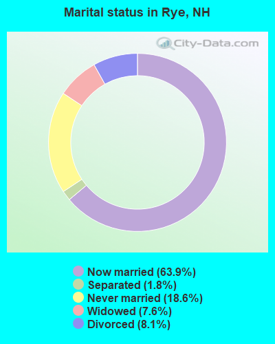
- Never married: 18.6%
- Now married: 63.9%
- Separated: 1.8%
- Widowed: 7.6%
- Divorced: 8.1%
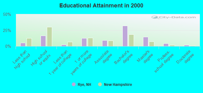
For population 25 years and over in Rye:
- High school or higher: 94.5%
- Bachelor's degree or higher: 53.3%
- Graduate or professional degree: 21.1%
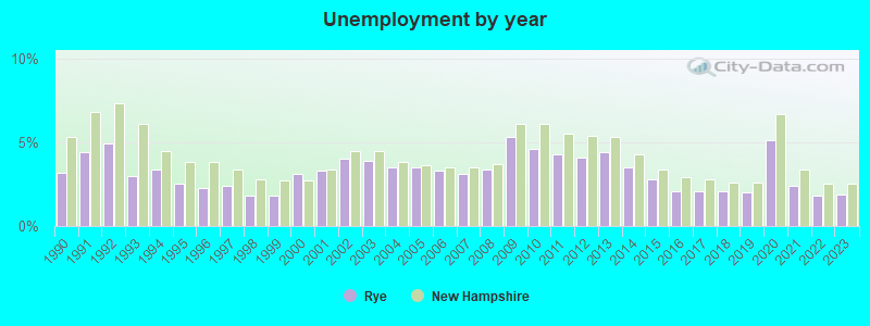
- Unemployed: 4.7%
- Mean travel time to work (commute): 30.2 minutes
| Here: | 9.3 |
| New Hampshire average: | 10.9 |


Graphs represent county-level data. Detailed 2008 Election Results
Religion statistics for Rye, NH (based on Rockingham County data)


| Religion | Adherents | Congregations |
|---|---|---|
| Catholic | 84,697 | 24 |
| Mainline Protestant | 19,072 | 78 |
| Evangelical Protestant | 7,456 | 61 |
| Other | 3,490 | 20 |
| Orthodox | 200 | 1 |
| None | 180,308 | - |
Food Environment Statistics:
| Rockingham County: | 1.59 / 10,000 pop. |
| New Hampshire: | 2.14 / 10,000 pop. |
| This county: | 0.17 / 10,000 pop. |
| New Hampshire: | 0.15 / 10,000 pop. |
| This county: | 1.86 / 10,000 pop. |
| New Hampshire: | 1.78 / 10,000 pop. |
| Rockingham County: | 3.31 / 10,000 pop. |
| New Hampshire: | 4.02 / 10,000 pop. |
| This county: | 9.56 / 10,000 pop. |
| New Hampshire: | 9.70 / 10,000 pop. |
| This county: | 7.6% |
| New Hampshire: | 7.6% |
| Rockingham County: | 23.3% |
| State: | 24.4% |
| Rockingham County: | 16.8% |
| New Hampshire: | 15.9% |
7.69% of this county's 2021 resident taxpayers lived in other counties in 2020 ($114,534 average adjusted gross income)
| Here: | 7.69% |
| New Hampshire average: | 7.66% |
0.01% of residents moved from foreign countries ($203 average AGI)
Rockingham County: 0.01% New Hampshire average: 0.01%
Top counties from which taxpayers relocated into this county between 2020 and 2021:
| from Essex County, MA | |
| from Hillsborough County, NH | |
| from Middlesex County, MA |
6.82% of this county's 2020 resident taxpayers moved to other counties in 2021 ($88,778 average adjusted gross income)
| Here: | 6.82% |
| New Hampshire average: | 6.80% |
0.01% of residents moved to foreign countries ($126 average AGI)
Rockingham County: 0.01% New Hampshire average: 0.01%
Top counties to which taxpayers relocated from this county between 2020 and 2021:
| to Hillsborough County, NH | |
| to Strafford County, NH | |
| to Essex County, MA |
| Businesses in Rye, NH | ||||
| Name | Count | Name | Count | |
|---|---|---|---|---|
| Curves | 1 | MasterBrand Cabinets | 6 | |
| FedEx | 2 | Vans | 1 | |
| Goodwill | 2 | |||
Strongest AM radio stations in Rye:
- WGIP (1540 AM; 5 kW; EXETER, NH; Owner: CAPSTAR TX LIMITED PARTNERSHIP)
- WRKO (680 AM; 50 kW; BOSTON, MA; Owner: ENTERCOM BOSTON LICENSE, LLC)
- WMYF (1380 AM; 1 kW; PORTSMOUTH, NH; Owner: CAPSTAR TX LIMITED PARTNERSHIP)
- WGIN (930 AM; 10 kW; ROCHESTER, NH; Owner: CAPSTAR TX LIMITED PARTNERSHIP)
- WTSN (1270 AM; 5 kW; DOVER, NH; Owner: GARRISON CITY BROADCASTING, INC.)
- WBZ (1030 AM; 50 kW; BOSTON, MA; Owner: INFINITY BROADCASTING OPERATIONS, INC.)
- WEEI (850 AM; 50 kW; BOSTON, MA; Owner: ENTERCOM BOSTON LICENSE, LLC)
- WWZN (1510 AM; 50 kW; BOSTON, MA; Owner: ROSE CITY RADIO CORPORATION)
- WKOX (1200 AM; 50 kW; FRAMINGHAM, MA; Owner: CAPSTAR TX LIMITED PARTNERSHIP)
- WBIX (1060 AM; 40 kW; NATICK, MA; Owner: LANGER BROADCASTING CORPORATION)
- WDER (1320 AM; 10 kW; DERRY, NH; Owner: BLOUNT COMMUNICATIONS, INC. OF NH)
- WCRN (830 AM; 50 kW; WORCESTER, MA; Owner: CARTER BROADCASTING CORPORATION)
- WRCA (1330 AM; 25 kW; WALTHAM, MA; Owner: WRCA LICENSE, LLC)
Strongest FM radio stations in Rye:
- WHEB (100.3 FM; PORTSMOUTH, NH; Owner: CAPSTAR TX LIMITED PARTNERSHIP)
- WERZ (107.1 FM; EXETER, NH; Owner: CAPSTAR TX LIMITED PARTNERSHIP)
- WUBB (95.3 FM; YORK CENTER, ME; Owner: CAPSTAR TX LIMITED PARTNERSHIP)
- WSAK (102.1 FM; HAMPTON, NH; Owner: CITADEL BROADCASTING COMPANY)
- WSHK (105.3 FM; KITTERY, ME; Owner: CITADEL BROADCASTING COMPANY)
- WNEF (91.7 FM; NEWBURYPORT, MA; Owner: UNIVERSITY OF MASSACHUSETTS)
- WXRV (92.5 FM; HAVERHILL, MA; Owner: BEANPOT BROADCASTING CORP.)
- WOKQ (97.5 FM; DOVER, NH; Owner: CITADEL BROADCASTING COMPANY)
- WSCY (106.9 FM; MOULTONBOROUGH, NH; Owner: NORTHEAST COMMUNICATIONS CORPORATION)
- WMEA (90.1 FM; PORTLAND, ME; Owner: MAINE PUBLIC BROADCASTING CORPORATION)
- WUNH (91.3 FM; DURHAM, NH; Owner: UNIVERSITY OF NEW HAMPSHIRE)
- WGIR-FM (101.1 FM; MANCHESTER, NH; Owner: CAPSTAR TX LIMITED PARTNERSHIP)
- WPHX-FM (92.1 FM; SANFORD, ME; Owner: FNX BROADCASTING LLC)
- WSEW (88.5 FM; SANFORD, ME; Owner: WORD RADIO EDUCATIONAL FOUNDATION)
- WXKS-FM (107.9 FM; MEDFORD, MA; Owner: AMFM RADIO LICENSES, L.L.C.)
- WBYY (98.7 FM; SOMERSWORTH, NH; Owner: GARRISON CITY BROADCASTING, INC.)
- WMEX (106.5 FM; FARMINGTON, NH; Owner: WIMMEX, LLC)
- WQLL (96.5 FM; BEDFORD, NH; Owner: SAGA COMMUNICATIONS OF NEW ENGLAND, LLC)
- WLMW (90.7 FM; MANCHESTER, NH; Owner: KNOWLEDGE FOR LIFE)
- WZID (95.7 FM; MANCHESTER, NH; Owner: SAGA COMMUNICATIONS OF NEW ENGLAND, LLC)
TV broadcast stations around Rye:
- WHDN-LP (Channel 26; BOSTON, MA; Owner: GUENTER MARKSTEINER)
- WMEA-TV (Channel 26; BIDDEFORD, ME; Owner: MAINE PUBLIC BROADCASTING CORP.)
- WFXZ-CA (Channel 24; BOSTON, MA; Owner: BOSTON BROADCASTING CORP.)
- WENH-TV (Channel 11; DURHAM, NH; Owner: UNIVERSITY OF NEW HAMPSHIRE)
- National Bridge Inventory (NBI) Statistics
- 5Number of bridges
- 36ft / 11.2mTotal length
- $15,710,000Total costs
- 7,510Total average daily traffic
- 298Total average daily truck traffic
- 11,112Total future (year 2042) average daily traffic
FCC Registered Cell Phone Towers:
1- 96 Grove Rd (Lat: 42.994639 Lon: -70.782917), Type: Mtower, Structure height: 59.4 m, Call Sign: KNKA226
Assigned Frequencies: 869.040 MHz, 869.040 MHz, 869.040 MHz, 824.040 MHz, 824.040 MHz, 824.040 MHz, 890.010 MHz, 890.010 MHz, 890.010 MHz, 845.010 MHz, 845.010 MHz, 845.010 MHzGrant Date: 09/09/2014, Expiration Date: 10/01/2024, Certifier: Michael P GogginRegistrant: At&t Services, Inc., 208 S Akard St, 20f, Dallas, TX 75202, Phone: (855) 699-7073, Fax: (214) 746-6410, Email:
FCC Registered Antenna Towers:
6- Christopher J Mahoney, Johnson Lane Off Grove Road (Lat: 42.994639 Lon: -70.782917), Type: 59.4, Overall height: 59.4 m, Registrant: National Grid Communications, Inc., Doug.Weist@gridcom.Com, , Westb-orough, Phone: (508) 389-3000
- Christopher F Ciolfi, Johnson Lane Off Grove Road (Lat: 42.994639 Lon: -70.782917), Type: 59.4, Overall height: 59.4 m, Registrant: National Grid Communications, Inc, Martin.Cohen@gridcom.Com, , Westb-orough, Phone: (508) 389-3000
- Christopher F Ciolfi, Johnson Lane Off Grove Road (Lat: 42.994639 Lon: -70.782917), Type: 59.4, Overall height: 59.4 m, Registrant: National Grid Communications, Inc., Laura.Room@us.Ngridwireless.Com, , Boxbo-rough, Phone: (978) 264-6030
- Edward G Roach, Johnson Lane Off Grove Road (Lat: 42.994639 Lon: -70.782917), Type: 59.4, Overall height: 59.4 m, Registrant: Sba Towers Ii LLC, Eroach@sbasite.Com, , Boca -Raton, Phone: (561) 995-7670
- Edward G Roach, 96 Johnson Lane (Nh13785-A) (Lat: 42.994583 Lon: -70.782778), Type: 58.8, Structure height: 33015 m, Overall height: 57.9 m, Registrant: Sba Towers Ii LLC, Eroach@sbasite.Com, , Boca -Raton, Phone: (561) 995-7670
- Edward G Roach, 96 Johnson Lane (Nh13785-A) (Lat: 42.994583 Lon: -70.782778), Type: 58.8, Structure height: 33015 m, Overall height: 57.9 m, Registrant: Sba Towers Ii LLC, Eroach@sbasite.Com, , Boca -Raton, Phone: (561) 995-7670
FCC Registered Broadcast Land Mobile Towers:
7- 561 Washington Rd (Lat: 43.011750 Lon: -70.772556), Call Sign: KCD686, Licensee ID: L00071746,
Assigned Frequencies: 155.250 MHz, Grant Date: 09/11/2004, Expiration Date: 09/26/2014, Cancellation Date: 11/29/2014, Registrant: Rye, Town Of, 37 Central Rd, Rye, NH 03870, Phone: (603) 964-5521
- Rye Police Dept 561 Washington Rd (Lat: 43.011750 Lon: -70.772556), Call Sign: KVI699, Licensee ID: L00008549,
Assigned Frequencies: 155.475 MHz, 156.090 MHz, Grant Date: 06/05/1997, Expiration Date: 07/01/2002, Cancellation Date: 11/03/2002, Registrant: State Of New Hampshire, Hazen Dr, Concord, NH 03301, Phone: (603) 271-2421
- 795 Washington Road (Lat: 43.005556 Lon: -70.784778), Call Sign: WQRR671,
Assigned Frequencies: 461.825 MHz, 464.300 MHz, 463.375 MHz, 464.200 MHz, 461.675 MHz, Grant Date: 07/15/2013, Expiration Date: 07/15/2023, Cancellation Date: 09/20/2013, Certifier: Tom Argue, Registrant: Federal Licensing Inc, 1588 Fairfield Road, Gettysburg, PA 17325, Phone: (717) 334-9262, Fax: (717) 334-6440
- 795 Washington Street (Lat: 43.005556 Lon: -70.784778), Call Sign: WQXH293,
Assigned Frequencies: 461.825 MHz, 464.300 MHz, 463.375 MHz, 464.200 MHz, 461.675 MHz, 461.300 MHz, 462.475 MHz, 469.475 MHz, Grant Date: 03/03/2016, Expiration Date: 03/03/2026, Certifier: Thomas Argue, Registrant: National License, 12591 Brompton Road, Carmel, IN 46033, Phone: (317) 564-8018, Fax: (317) 564-8335, Email:
- Lat: 43.059833 Lon: -70.726194, Call Sign: WQXK953,
Assigned Frequencies: 452.637 MHz, 457.637 MHz, 452.787 MHz, 457.787 MHz, Grant Date: 04/05/2016, Expiration Date: 04/05/2026, Certifier: Jason Bastille, Registrant: Cara Enterprises Inc, Las Vegas, NV 89140-0124, Phone: (702) 838-9728, Fax: (702) 363-4607, Email:
- 295 Lafayette Road (Lat: 43.003500 Lon: -70.811139), Call Sign: WRKD866,
Assigned Frequencies: 468.512 MHz, 469.087 MHz, 467.025 MHz, 468.487 MHz, Grant Date: 12/17/2020, Expiration Date: 12/17/2030, Certifier: Richard Martini, Registrant: National License, 12591 Brompton Road, Carmel, IN 46033, Phone: (317) 564-8018, Email:
- Lat: 43.005111 Lon: -70.809806, Call Sign: WRML335,
Assigned Frequencies: 468.900 MHz, Grant Date: 04/27/2021, Expiration Date: 04/27/2031, Certifier: Jose D Mena, Registrant: Kamstrup Water Metering, LLC, 245 Hembree Park Drive, Ste. 110, Roswell, GA 30076, Phone: (404) 835-6716
FCC Registered Microwave Towers:
2- RYE, Lat: 43.045139 Lon: -70.746500, Call Sign: WQKG774,
Assigned Frequencies: 952.568 MHz, Grant Date: 03/14/2019, Expiration Date: 05/13/2029, Certifier: Ken Aspen, Registrant: Sensus, 450 N Gallatin Avenue, Uniontown, PA 15401, Phone: (800) 638-3748, Fax: (800) 888-2403, Email:
- RYEWATERTANK, Breakfast Hill Tank, Lafayette Rd Us Rt 1 (Lat: 43.005083 Lon: -70.809917), Type: Tank, Structure height: 30.5 m, Call Sign: WRZF271, Licensee ID: L00002006,
Assigned Frequencies: 11325.0 MHz, 11325.0 MHz, 11325.0 MHz, 11325.0 MHz, 11325.0 MHz, 11325.0 MHz, 11325.0 MHz, 11325.0 MHz, 11325.0 MHz, 11325.0 MHz, 11325.0 MHz, Grant Date: 10/25/2023, Expiration Date: 10/25/2033, Certifier: Tobias Dannhausen, Registrant: Rockingham County Sheriffs Office, 101 North Road, Brentwood, NH 03833, Phone: (603) 679-9338, Email:
FCC Registered Maritime Coast & Aviation Ground Towers:
2- Rt 1a Ocean Blvd (Lat: 43.001750 Lon: -70.752278), Overall height: 2 m, Call Sign: WHG641, Licensee ID: L00002883,
Assigned Frequencies: 156.450 MHz, 156.800 MHz, 156.950 MHz, 157.025 MHz, Grant Date: 10/31/2002, Expiration Date: 01/15/2013, Cancellation Date: 03/23/2013, Registrant: New Hampshire Seacoast Cruises Incorporated, Rye, NH 03870, Phone: (603) 964-5545, Fax: (603) 964-8039, Email:
- 495 South Rd (Lat: 42.916750 Lon: -70.916167), Type: Building, Overall height: 9 m, Call Sign: WHH268,
Assigned Frequencies: 4.12640 MHz, 4.14740 MHz, Grant Date: 03/29/1995, Expiration Date: 03/29/2000, Cancellation Date: 05/06/2001, Registrant: Pauline Pearl Fisheries Inc, 495 South Rd, Rye, NH 03870
FCC Registered Amateur Radio Licenses:
27 (See the full list of FCC Registered Amateur Radio Licenses in Rye)FAA Registered Aircraft:
21 (See the full list of FAA Registered Aircraft in Rye)2006 - 2018 National Fire Incident Reporting System (NFIRS) incidents
- Fire incident types reported to NFIRS in Rye, NH
- 17457.2%Structure Fires
- 9129.9%Outside Fires
- 237.6%Mobile Property/Vehicle Fires
- 165.3%Other
 Based on the data from the years 2006 - 2018 the average number of fire incidents per year is 23. The highest number of reported fires - 34 took place in 2007, and the least - 16 in 2012. The data has a dropping trend.
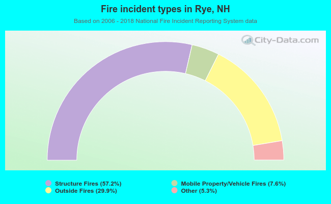 When looking into fire subcategories, the most reports belonged to: Structure Fires (57.2%), and Outside Fires (29.9%).
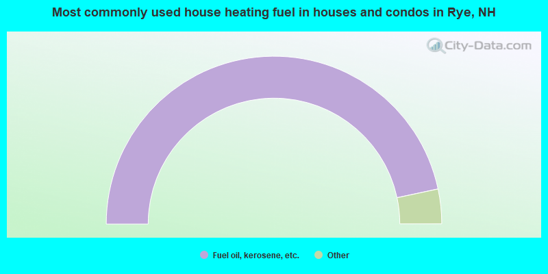
- 93.3%Fuel oil, kerosene, etc.
- 2.3%Bottled, tank, or LP gas
- 2.2%Electricity
- 1.1%Utility gas
- 1.0%Wood
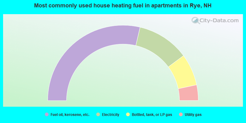
- 57.3%Fuel oil, kerosene, etc.
- 22.4%Electricity
- 13.6%Bottled, tank, or LP gas
- 6.7%Utility gas
Rye compared to New Hampshire state average:
- Median house value significantly above state average.
- Unemployed percentage below state average.
- Black race population percentage significantly below state average.
- Hispanic race population percentage significantly below state average.
- Median age above state average.
- Length of stay since moving in significantly above state average.
- Number of rooms per house significantly below state average.
- House age significantly below state average.
- Percentage of population with a bachelor's degree or higher above state average.
Rye on our top lists:
- #1 on the list of "Top 101 cities with largest percentage of females in occupations: air transportation workers (population 5,000+)"
- #2 on the list of "Top 101 cities with largest percentage of males in industries: professional and commercial equipment and supplies merchant wholesalers (population 5,000+)"
- #3 on the list of "Top 101 cities with largest percentage of males in occupations: air transportation workers (population 5,000+)"
- #4 on the list of "Top 101 cities with largest percentage of females in industries: paper and paper products merchant wholesalers (population 5,000+)"
- #6 on the list of "Top 101 cities with largest percentage of males in occupations: special education teachers (population 5,000+)"
- #9 on the list of "Top 101 cities with largest percentage of males in industries: radio, tv, and computer stores (population 5,000+)"
- #10 on the list of "Top 101 cities with largest percentage of males in industries: motor vehicle and parts dealers (population 5,000+)"
- #10 on the list of "Top 101 cities with largest percentage of females in occupations: religious workers (population 5,000+)"
- #11 on the list of "Top 101 cities with largest percentage of females in industries: radio, tv, and computer stores (population 5,000+)"
- #15 on the list of "Top 101 cities with largest percentage of males in industries: jewelry, luggage, and leather goods stores (population 5,000+)"
- #17 on the list of "Top 101 cities with largest percentage of females in occupations: farmers and farm managers (population 5,000+)"
- #19 on the list of "Top 101 cities with largest percentage of males in industries: air transportation (population 5,000+)"
- #23 on the list of "Top 101 cities with largest percentage of females in occupations: other sales and related workers including supervisors (population 5,000+)"
- #32 on the list of "Top 101 cities with the lowest number of burglaries per 100,000 residents (population 5,000+)"
- #39 on the list of "Top 101 cities with largest percentage of males in industries: apparel, fabrics, and notions merchant wholesalers (population 5,000+)"
- #40 on the list of "Top 101 cities with largest percentage of males in industries: clothing and accessories, including shoe, stores (population 5,000+)"
- #40 on the list of "Top 101 cities with largest percentage of females in industries: beverage and tobacco products (population 5,000+)"
- #67 on the list of "Top 101 cities with largest percentage of males in industries: sporting goods, camera, and hobby and toy stores (population 5,000+)"
- #70 on the list of "Top 101 cities with the highest percentage of workers working at home, population 5,000+"
- #72 on the list of "Top 101 cities with largest percentage of females in industries: apparel (population 5,000+)"
- #80 (03870) on the list of "Top 101 zip codes with the largest percentage of Greek first ancestries (pop 5,000+)"
- #9 on the list of "Top 101 counties with the largest decrease in the number of births per 1000 residents 2000-2006 to 2007-2013 (pop 50,000+)"
- #14 on the list of "Top 101 counties with the best general health status score of residents (1-5), 3 years of data"
- #16 on the list of "Top 101 counties with the lowest number of births per 1000 residents 2007-2013"
- #22 on the list of "Top 101 counties with the lowest Particulate Matter (PM10) Annual air pollution readings in 2012 (µg/m3)"
- #36 on the list of "Top 101 counties with the highest percentage of residents that visited a dentist within the past year"

|
|
Total of 114 patent applications in 2008-2024.