Bridge Statistics for Shreveport, Louisiana (LA)
Condition, Traffic, Stress, Structural Evaluation, Project Costs
- National Bridge Inventory (NBI) Statistics
- 597Number of bridges
- 16,152ft / 4,923mTotal length
- $170,149,000Total costs
- 10,099,910Total average daily traffic
- 802,012Total average daily truck traffic
- National Bridge Inventory (NBI) Registered Bridges for Shreveport
- No street view available for this location
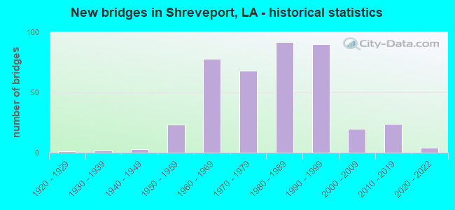
- New bridges - historical statistics
- 11920-1929
- 21930-1939
- 31940-1949
- 231950-1959
- 781960-1969
- 681970-1979
- 921980-1989
- 901990-1999
- 202000-2009
- 242010-2019
- 42020-2022
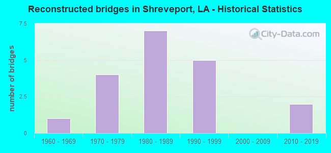
- Reconstructed bridges - Historical Statistics
- 11960-1969
- 41970-1979
- 71980-1989
- 51990-1999
- 02000-2009
- 22010-2019
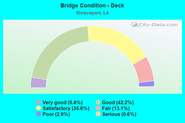
- Bridge Condition - Deck
- 5.4%Very good
- 42.2%Good
- 35.8%Satisfactory
- 13.1%Fair
- 2.9%Poor
- 0.6%Serious
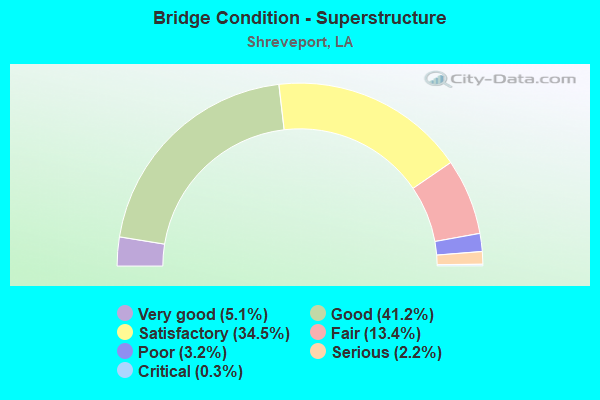
- Bridge Condition - Superstructure
- 5.1%Very good
- 41.2%Good
- 34.5%Satisfactory
- 13.4%Fair
- 3.2%Poor
- 2.2%Serious
- 0.3%Critical
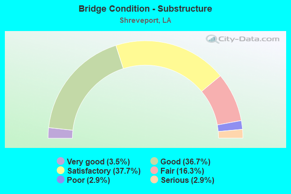
- Bridge Condition - Substructure
- 3.5%Very good
- 36.7%Good
- 37.7%Satisfactory
- 16.3%Fair
- 2.9%Poor
- 2.9%Serious
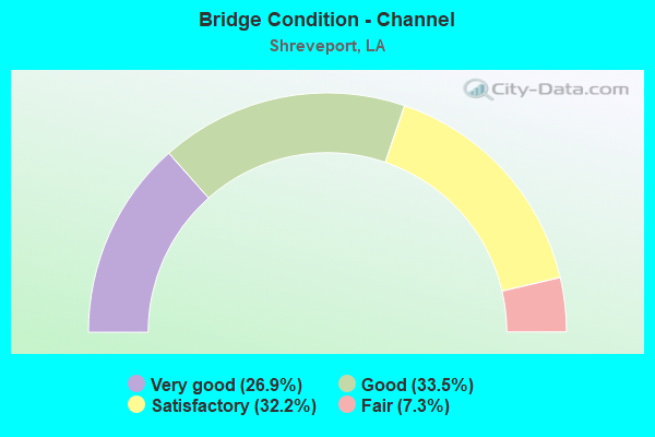
- Bridge Condition - Channel
- 26.9%Very good
- 33.5%Good
- 32.2%Satisfactory
- 7.3%Fair
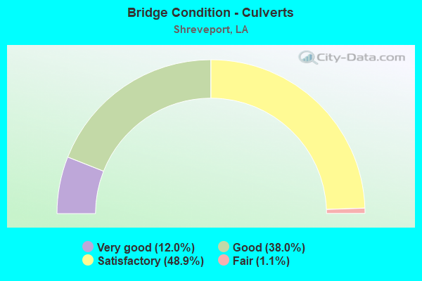
- Bridge Condition - Culverts
- 12.0%Very good
- 38.0%Good
- 48.9%Satisfactory
- 1.1%Fair
Find on map >> Show street view
Structure Number: 40904510116561, Location: I-20 OVER US 80 (Lat: 32.485189, Lng: -93.773900), Route carried "on" structure: Interstate 20, Year Built: 1965, Status: Open, Structure Length: 6.19m (20.31ft), Average Daily Traffic: 32,950 (year 2016), Truck Traffic: 19%, Average Future Daily Traffic: 46,728 (year 2036), Design Load: HS 20, Features Intersected: US 80/GREENWOOD RD.
Minimum Vertical Clearance: 30+ m (98+ ft), Kilometerpoint: 26.667, Lanes on structure: 3, Lanes under structure: 2, Base Highway Network: Yes (Inventory Route: 451-01-1, Subroute: 10), Owner: State Highway Agency, Approaching Roadway Width: 15.9m (52.2ft), Skew: 12 degrees, Material/Design: Concrete, Design/Construction: Tee Beam, Number Of Spans In Main Unit: 3, Length of Maximum Span: 25.3m (83.0ft), Curb-To-Curb Width: 12.3m (40.4ft), Out-to-Out Width: 13.9m (45.6ft)
Condition: Deck: Fair, Superstructure: Fair, Substructure: Fair, Operating Rating: 60.8 metric tons, Method Used To Determine Operating Rating: Load Factor (LF), Inventory Rating: 36.3 metric tons, Method Used To Determine Inventory Rating: Load Factor (LF), Structural Evaluation: Somewhat better than minimum adequacy, Deck Geometry: Meets minimum limits, Underclear: High priority of replacement, Approach Roadway Alignment: Equal to present desirable criteria, Length Of Structure Improvement: 7.10m (23.29ft), Designated Inspection Frequency: Every 24 months, Inspection Date: Febuary 2021, Bridge Improvement Cost: $608,000, Total Project Cost: $912,000 ( Estimate for 2016), Deck Structure Type: Concrete Cast-file-Place
Find on map >> Show street view
Structure Number: 40904510116562, Location: I-20 OVER US 80 (Lat: 32.485681, Lng: -93.773900), Route carried "on" structure: Interstate 20, Year Built: 1965, Status: Open, Structure Length: 6.19m (20.31ft), Average Daily Traffic: 32,950 (year 2016), Truck Traffic: 19%, Average Future Daily Traffic: 46,728 (year 2036), Design Load: HS 20, Features Intersected: US 80/GREENWOOD RD.
Minimum Vertical Clearance: 30+ m (98+ ft), Kilometerpoint: 4.511, Lanes on structure: 3, Lanes under structure: 2, Base Highway Network: Yes (Inventory Route: 451-01-2, Subroute: 10), Owner: State Highway Agency, Approaching Roadway Width: 15.9m (52.2ft), Skew: 2 degrees, Material/Design: Concrete, Design/Construction: Tee Beam, Number Of Spans In Main Unit: 3, Length of Maximum Span: 25.3m (83.0ft), Curb-To-Curb Width: 12.3m (40.4ft), Out-to-Out Width: 13.9m (45.6ft)
Condition: Deck: Fair, Superstructure: Fair, Substructure: Fair, Operating Rating: 60.8 metric tons, Method Used To Determine Operating Rating: Load Factor (LF), Inventory Rating: 36.3 metric tons, Method Used To Determine Inventory Rating: Load Factor (LF), Structural Evaluation: Somewhat better than minimum adequacy, Deck Geometry: Meets minimum limits, Underclear: High priority of replacement, Approach Roadway Alignment: Equal to present desirable criteria, Length Of Structure Improvement: 7.10m (23.29ft), Designated Inspection Frequency: Every 24 months, Inspection Date: Febuary 2021, Bridge Improvement Cost: $608,000, Total Project Cost: $912,000 ( Estimate for 2016), Deck Structure Type: Concrete Cast-file-Place
Find on map >> Show street view
Structure Number: 40904510116771, Location: .2 MI EAST OF US 80 (Lat: 32.488069, Lng: -93.773000), Route carried "on" structure: Interstate 20, Year Built: 1965, Status: Open, Structure Length: 4.51m (14.80ft), Average Daily Traffic: 32,950 (year 2016), Truck Traffic: 19%, Average Future Daily Traffic: 46,728 (year 2036), Design Load: HS 20, Features Intersected: MARION ST
Minimum Vertical Clearance: 30+ m (98+ ft), Kilometerpoint: 26.998, Lanes on structure: 4, Lanes under structure: 2, Base Highway Network: Yes (Inventory Route: 451-01-1, Subroute: 10), Owner: State Highway Agency, Approaching Roadway Width: 16.8m (55.1ft), Skew: 11 degrees, Material/Design: Concrete continuous, Design/Construction: Tee Beam, Number Of Spans In Main Unit: 3, Length of Maximum Span: 17.7m (58.1ft), Curb-To-Curb Width: 18.4m (60.4ft), Out-to-Out Width: 20.0m (65.6ft)
Condition: Deck: Fair, Superstructure: Fair, Substructure: Fair, Operating Rating: 50.8 metric tons, Method Used To Determine Operating Rating: Load Factor (LF), Inventory Rating: 30.8 metric tons, Method Used To Determine Inventory Rating: Load Factor (LF), Structural Evaluation: Somewhat better than minimum adequacy, Deck Geometry: Meets minimum limits, Underclear: Meets minimum limits, Approach Roadway Alignment: Equal to present desirable criteria, Designated Inspection Frequency: Every 24 months, Inspection Date: Febuary 2021, Deck Structure Type: Concrete Cast-file-Place
Find on map >> Show street view
Structure Number: 40904510116772, Location: .2 MI EAST OF US 80 (Lat: 32.488469, Lng: -93.773100), Route carried "on" structure: Interstate 20, Year Built: 1965, Status: Open, Structure Length: 4.51m (14.80ft), Average Daily Traffic: 32,950 (year 2016), Truck Traffic: 19%, Average Future Daily Traffic: 46,728 (year 2036), Design Load: HS 20, Features Intersected: MARION ST
Minimum Vertical Clearance: 30+ m (98+ ft), Kilometerpoint: 4.191, Lanes on structure: 4, Lanes under structure: 2, Base Highway Network: Yes (Inventory Route: 451-01-2, Subroute: 10), Owner: State Highway Agency, Approaching Roadway Width: 16.8m (55.1ft), Skew: 11 degrees, Material/Design: Concrete continuous, Design/Construction: Tee Beam, Number Of Spans In Main Unit: 3, Length of Maximum Span: 17.7m (58.1ft), Curb-To-Curb Width: 18.4m (60.4ft), Out-to-Out Width: 20.0m (65.6ft)
Condition: Deck: Fair, Superstructure: Fair, Substructure: Fair, Operating Rating: 56.2 metric tons, Method Used To Determine Operating Rating: Load Factor (LF), Inventory Rating: 33.6 metric tons, Method Used To Determine Inventory Rating: Load Factor (LF), Structural Evaluation: Somewhat better than minimum adequacy, Deck Geometry: Meets minimum limits, Approach Roadway Alignment: Equal to present desirable criteria, Designated Inspection Frequency: Every 24 months, Inspection Date: Febuary 2021, Deck Structure Type: Concrete Cast-file-Place
Find on map >> Show street view
Structure Number: 40904510117061, Location: .5 MI EAST OF US 80 (Lat: 32.491731, Lng: -93.770700), Route carried "on" structure: Interstate 20, Year Built: 1965, Status: Open, Structure Length: 24.45m (80.22ft), Average Daily Traffic: 31,800 (year 2018), Truck Traffic: 19%, Average Future Daily Traffic: 45,028 (year 2036), Design Load: HS 20, Features Intersected: LK SHORE DR&KESRR
Minimum Vertical Clearance: 30+ m (98+ ft), Kilometerpoint: 27.465, Lanes on structure: 2, Lanes under structure: 9, Base Highway Network: Yes (Inventory Route: 451-01-1, Subroute: 10), Owner: State Highway Agency, Approaching Roadway Width: 15.9m (52.2ft), Skew: 14 degrees, Material/Design: Steel continuous, Design/Construction: Girder and Floorbeam System, Number Of Spans In Main Unit: 8, Length of Maximum Span: 32.6m (107.0ft), Curb-To-Curb Width: 12.2m (40.0ft), Out-to-Out Width: 13.9m (45.6ft)
Condition: Deck: Fair, Superstructure: Serious, Substructure: Satisfactory, Operating Rating: 17.5 metric tons, Method Used To Determine Operating Rating: Load and Resistance Factor Rating (LRFR) rating reported by rating factor(RF) method using HL-93 loadings, Inventory Rating: 13.3 metric tons, Method Used To Determine Inventory Rating: Load and Resistance Factor Rating (LRFR) rating reported by rating factor(RF) method using HL-93 loadings, Structural Evaluation: High priority of replacement, Deck Geometry: Better than present minimum criteria, Underclear: High priority of replacement, Approach Roadway Alignment: Equal to present desirable criteria, Length Of Structure Improvement: 24.87m (81.59ft), Designated Inspection Frequency: Every 12 months, Inspection Date: Febuary 2022, Bridge Improvement Cost: $2,121,000, Total Project Cost: $3,181,000 ( Estimate for 2016), Deck Structure Type: Concrete Cast-file-Place
Find on map >> Show street view
Structure Number: 40904510117062, Location: .5 MI EAST OF US 80 (Lat: 32.493011, Lng: -93.768800), Route carried "on" structure: Interstate 20, Year Built: 1965, Year Reconstructed: 1993, Status: Open, Structure Length: 24.99m (81.99ft), Average Daily Traffic: 31,800 (year 2016), Truck Traffic: 19%, Average Future Daily Traffic: 45,028 (year 2036), Design Load: HS 20, Features Intersected: LK SHORE DR&KCSRR
Minimum Vertical Clearance: 30+ m (98+ ft), Kilometerpoint: 3.524, Lanes on structure: 4, Lanes under structure: 7, Base Highway Network: Yes (Inventory Route: 451-01-2, Subroute: 10), Owner: State Highway Agency, Approaching Roadway Width: 20.4m (66.9ft), Skew: 15 degrees, Material/Design: Steel continuous, Design/Construction: Girder and Floorbeam System, Number Of Spans In Main Unit: 5, Number Of Approach Spans: 3, Length of Maximum Span: 38.7m (127.0ft), Curb-To-Curb Width: 18.0m (59.1ft), Out-to-Out Width: 19.1m (62.7ft)
Condition: Deck: Fair, Superstructure: Fair, Substructure: Satisfactory, Operating Rating: 54.4 metric tons, Method Used To Determine Operating Rating: Load Factor (LF), Inventory Rating: 32.7 metric tons, Method Used To Determine Inventory Rating: Load Factor (LF), Structural Evaluation: Somewhat better than minimum adequacy, Deck Geometry: Meets minimum limits, Underclear: High priority of corrective action, Approach Roadway Alignment: Equal to present desirable criteria, Designated Inspection Frequency: Every 24 months, Inspection Date: June 2021, Deck Structure Type: Concrete Cast-file-Place
Find on map >> Show street view
Structure Number: 40904510117078, Location: .5 MI EAST OF US 80 (Lat: 32.493089, Lng: -93.769100), Route carried "on" structure: Ramp Interstate 20, Year Built: 1994, Status: Open, Structure Length: 21.92m (71.92ft), Average Daily Traffic: 6,360 (year 2016), Truck Traffic: 19%, Average Future Daily Traffic: 7,504 (year 2036), Design Load: HS 20, Features Intersected: KCS RR & ACCESS RD
Minimum Vertical Clearance: 30+ m (98+ ft), Kilometerpoint: 1.268, Lanes on structure: 2, Lanes under structure: 6, Owner: State Highway Agency, Approaching Roadway Width: 8.5m (27.9ft), Skew: 5 degrees, Material/Design: Steel continuous, Design/Construction: Girder and Floorbeam System, Number Of Spans In Main Unit: 1, Number Of Approach Spans: 7, Length of Maximum Span: 35.4m (116.1ft), Curb-To-Curb Width: 8.5m (27.9ft), Out-to-Out Width: 9.4m (30.8ft)
Condition: Deck: Good, Superstructure: Good, Substructure: Good, Operating Rating: 54.4 metric tons, Method Used To Determine Operating Rating: Load Factor (LF), Inventory Rating: 32.7 metric tons, Method Used To Determine Inventory Rating: Load Factor (LF), Structural Evaluation: Better than present minimum criteria, Deck Geometry: High priority of corrective action, Underclear: High priority of replacement, Approach Roadway Alignment: Equal to present desirable criteria, Length Of Structure Improvement: 22.49m (73.79ft), Designated Inspection Frequency: Every 24 months, Inspection Date: June 2020, Bridge Improvement Cost: $1,918,000, Total Project Cost: $2,877,000 ( Estimate for 2016), Deck Structure Type: Concrete Cast-file-Place
Find on map >> Show street view
Structure Number: 40904510117155, Location: .6 MI EAST OF US 80 (Lat: 32.492169, Lng: -93.769500), Route carried "on" structure: Ramp Interstate 20, Year Built: 1994, Status: Open, Structure Length: 14.97m (49.11ft), Average Daily Traffic: 6,360 (year 2016), Truck Traffic: 19%, Average Future Daily Traffic: 7,504 (year 2036), Design Load: HS 20, Features Intersected: KCS RR & ACCESS ROAD
Minimum Vertical Clearance: 30+ m (98+ ft), Kilometerpoint: 0.394, Lanes on structure: 2, Lanes under structure: 6, Owner: State Highway Agency, Approaching Roadway Width: 10.7m (35.1ft), Skew: 5 degrees, Material/Design: Steel continuous, Design/Construction: Girder and Floorbeam System, Number Of Spans In Main Unit: 1, Number Of Approach Spans: 4, Length of Maximum Span: 36.3m (119.1ft), Curb-To-Curb Width: 8.5m (27.9ft), Out-to-Out Width: 9.4m (30.8ft)
Condition: Deck: Good, Superstructure: Good, Substructure: Good, Operating Rating: 54.4 metric tons, Method Used To Determine Operating Rating: Load Factor (LF), Inventory Rating: 32.7 metric tons, Method Used To Determine Inventory Rating: Load Factor (LF), Structural Evaluation: Better than present minimum criteria, Deck Geometry: High priority of corrective action, Underclear: High priority of replacement, Approach Roadway Alignment: Equal to present desirable criteria, Length Of Structure Improvement: 15.88m (52.10ft), Designated Inspection Frequency: Every 24 months, Inspection Date: March 2020, Bridge Improvement Cost: $1,354,000, Total Project Cost: $2,031,000 ( Estimate for 2016), Deck Structure Type: Concrete Cast-file-Place
Find on map >> Show street view
Structure Number: 40904510117627, Location: I-20 OVER I-49 RAMP (Lat: 32.495331, Lng: -93.762061), Route carried "on" structure: Ramp Interstate 20, Year Built: 1993, Status: Open, Structure Length: 43.25m (141.90ft), Average Daily Traffic: 6,360 (year 2016), Truck Traffic: 19%, Average Future Daily Traffic: 7,504 (year 2036), Design Load: HS 20, Features Intersected: LINWOOD AVE, I-49, RAMP
Minimum Vertical Clearance: 5.49m (18.01ft), Kilometerpoint: 0.097, Lanes on structure: 1, Lanes under structure: 14, Owner: State Highway Agency, Approaching Roadway Width: 15.2m (49.9ft), Material/Design: Steel continuous, Design/Construction: Box Beam or Girders - Multiple, Number Of Spans In Main Unit: 2, Number Of Approach Spans: 8, Length of Maximum Span: 53.3m (174.9ft), Curb-To-Curb Width: 7.8m (25.6ft), Out-to-Out Width: 8.8m (28.9ft)
Condition: Deck: Good, Superstructure: Good, Substructure: Good, Operating Rating: 59.9 metric tons, Method Used To Determine Operating Rating: Load Factor (LF), Inventory Rating: 36.3 metric tons, Method Used To Determine Inventory Rating: Load Factor (LF), Structural Evaluation: Better than present minimum criteria, Deck Geometry: Better than present minimum criteria, Underclear: High priority of corrective action, Approach Roadway Alignment: Equal to present desirable criteria, Designated Inspection Frequency: Every 24 months, Critical Feature Inspection Frequency: Every 24 months, Inspection Date: April 2021, Critical Feature Inspection Date: April 2021, Deck Structure Type: Concrete Cast-file-Place
Find on map >> Show street view
Structure Number: 40904510117646, Location: I-20 OVER I-49 RAMP (Lat: 32.496961, Lng: -93.761800), Route carried "on" structure: Ramp Interstate 20, Year Built: 1993, Status: Open, Structure Length: 10.06m (33.01ft), Average Daily Traffic: 6,360 (year 2016), Truck Traffic: 19%, Average Future Daily Traffic: 7,504 (year 2036), Design Load: HS 20, Features Intersected: LINWOOD AVENUE
Minimum Vertical Clearance: 30+ m (98+ ft), Kilometerpoint: 0.344, Lanes on structure: 1, Lanes under structure: 5, Owner: State Highway Agency, Approaching Roadway Width: 7.6m (24.9ft), Material/Design: Steel continuous, Design/Construction: Box Beam or Girders - Multiple, Number Of Spans In Main Unit: 2, Length of Maximum Span: 50.3m (165.0ft), Curb-To-Curb Width: 7.6m (24.9ft), Out-to-Out Width: 8.5m (27.9ft)
Condition: Deck: Good, Superstructure: Good, Substructure: Good, Operating Rating: 57.1 metric tons, Method Used To Determine Operating Rating: Load Factor (LF), Inventory Rating: 34.5 metric tons, Method Used To Determine Inventory Rating: Load Factor (LF), Structural Evaluation: Better than present minimum criteria, Deck Geometry: Better than present minimum criteria, Underclear: High priority of corrective action, Approach Roadway Alignment: Better than present minimum criteria, Designated Inspection Frequency: Every 24 months, Critical Feature Inspection Frequency: Every 24 months, Inspection Date: April 2021, Critical Feature Inspection Date: April 2021, Deck Structure Type: Concrete Cast-file-Place
Find on map >> Show street view
Structure Number: 40904510117661, Location: .1 MI EAST OF I-49 (Lat: 32.495569, Lng: -93.761500), Route carried "on" structure: City street , Year Built: 1993, Status: Open, Structure Length: 5.36m (17.59ft), Average Daily Traffic: 31,800 (year 2015), Average Future Daily Traffic: 37,524 (year 2036), Design Load: HS 20, Features Intersected: I-20, Facility Carried by Structure: LINWOOD AVE
Minimum Vertical Clearance: 30+ m (98+ ft), Kilometerpoint: 28.410, Lanes on structure: 6, Lanes under structure: 6, Owner: State Highway Agency, Approaching Roadway Width: 14.6m (47.9ft), Skew: 20 degrees, Material/Design: Prestressed concrete, Design/Construction: Stringer/Multi-beam, Number Of Spans In Main Unit: 2, Length of Maximum Span: 26.8m (87.9ft), Curb or Sidewalk Widths: Left: 1.5m (4.9ft), Right: 1.5m (4.9ft), Curb-To-Curb Width: 23.2m (76.1ft), Out-to-Out Width: 26.8m (87.9ft)
Condition: Deck: Satisfactory, Superstructure: Satisfactory, Substructure: Good, Operating Rating: 59.0 metric tons, Method Used To Determine Operating Rating: Load Factor (LF), Inventory Rating: 35.4 metric tons, Method Used To Determine Inventory Rating: Load Factor (LF), Structural Evaluation: Equal to present minimum criteria, Deck Geometry: Meets minimum limits, Approach Roadway Alignment: Equal to present desirable criteria, Designated Inspection Frequency: Every 24 months, Inspection Date: March 2020, Deck Structure Type: Concrete Cast-file-Place
Find on map >> Show street view
Structure Number: 40904510118261, Location: .01 MI N OF Southern Ave (Lat: 32.499511, Lng: -93.752500), Route carried "on" structure: City street , Year Built: 1994, Status: Open, Structure Length: 4.39m (14.40ft), Average Daily Traffic: 54,700 (year 2015), Average Future Daily Traffic: 64,546 (year 2036), Design Load: HS 20, Features Intersected: I-20, Facility Carried by Structure: Fairfield Ave
Minimum Vertical Clearance: 30+ m (98+ ft), Kilometerpoint: 29.369, Lanes on structure: 5, Lanes under structure: 9, Base Highway Network: Yes (Inventory Route: 451-01-1, Subroute: 10), Owner: State Highway Agency, Approaching Roadway Width: 19.5m (64.0ft), Skew: 21 degrees, Material/Design: Steel continuous, Design/Construction: Girder and Floorbeam System, Number Of Spans In Main Unit: 2, Length of Maximum Span: 26.5m (86.9ft), Curb or Sidewalk Widths: Left: 1.2m (3.9ft), Right: 1.2m (3.9ft), Curb-To-Curb Width: 19.5m (64.0ft), Out-to-Out Width: 23.2m (76.1ft)
Condition: Deck: Good, Superstructure: Good, Substructure: Good, Operating Rating: 77.1 metric tons, Method Used To Determine Operating Rating: Load Factor (LF), Inventory Rating: 46.3 metric tons, Method Used To Determine Inventory Rating: Load Factor (LF), Structural Evaluation: Better than present minimum criteria, Deck Geometry: Meets minimum limits, Underclear: Meets minimum limits, Approach Roadway Alignment: Equal to present desirable criteria, Designated Inspection Frequency: Every 24 months, Inspection Date: March 2020, Deck Structure Type: Concrete Cast-file-Place
Find on map >> Show street view
Structure Number: 40904510118271, Location: .9 MI EAST OF US 80 (Lat: 32.499969, Lng: -93.751600), Route carried "on" structure: City street , Year Built: 1994, Status: Open, Structure Length: 8.20m (26.90ft), Average Daily Traffic: 54,700 (year 2015), Average Future Daily Traffic: 64,546 (year 2036), Design Load: HS 20, Features Intersected: I-20 - STONER AVE, Facility Carried by Structure: STONER AVE
Minimum Vertical Clearance: 30+ m (98+ ft), Kilometerpoint: 29.425, Lanes on structure: 4, Lanes under structure: 9, Owner: State Highway Agency, Approaching Roadway Width: 15.9m (52.2ft), Skew: 25 degrees, Material/Design: Steel continuous, Design/Construction: Girder and Floorbeam System, Number Of Spans In Main Unit: 2, Length of Maximum Span: 43.3m (142.1ft), Curb or Sidewalk Widths: Left: 1.5m (4.9ft), Right: 1.5m (4.9ft), Curb-To-Curb Width: 15.9m (52.2ft), Out-to-Out Width: 19.6m (64.3ft)
Condition: Deck: Good, Superstructure: Good, Substructure: Good, Operating Rating: 57.1 metric tons, Method Used To Determine Operating Rating: Load Factor (LF), Inventory Rating: 34.5 metric tons, Method Used To Determine Inventory Rating: Load Factor (LF), Structural Evaluation: Better than present minimum criteria, Deck Geometry: Meets minimum limits, Underclear: Meets minimum limits, Approach Roadway Alignment: Equal to present desirable criteria, Designated Inspection Frequency: Every 24 months, Inspection Date: March 2020, Deck Structure Type: Concrete Cast-file-Place
Find on map >> Show street view
Structure Number: 40904510118491, Location: 1.0 MI EAST OF US I-49 (Lat: 32.501711, Lng: -93.749600), Route carried "on" structure: Interstate 20, Year Built: 1964, Year Reconstructed: 2001, Status: Open, Structure Length: 4.75m (15.58ft), Average Daily Traffic: 56,100 (year 2016), Truck Traffic: 19%, Average Future Daily Traffic: 77,455 (year 2036), Design Load: HS 20, Features Intersected: SAM R FERTITTA STREET
Minimum Vertical Clearance: 30+ m (98+ ft), Kilometerpoint: 29.744, Lanes on structure: 4, Lanes under structure: 2, Base Highway Network: Yes (Inventory Route: 451-01-1, Subroute: 10), Owner: State Highway Agency, Approaching Roadway Width: 20.7m (67.9ft), Skew: 10 degrees, Material/Design: Concrete, Design/Construction: Tee Beam, Number Of Spans In Main Unit: 1, Number Of Approach Spans: 2, Length of Maximum Span: 19.2m (63.0ft), Curb-To-Curb Width: 18.4m (60.4ft), Out-to-Out Width: 19.8m (65.0ft)
Condition: Deck: Satisfactory, Superstructure: Satisfactory, Substructure: Good, Operating Rating: 83.4 metric tons, Method Used To Determine Operating Rating: Load Factor (LF), Inventory Rating: 49.9 metric tons, Method Used To Determine Inventory Rating: Load Factor (LF), Structural Evaluation: Equal to present minimum criteria, Deck Geometry: Meets minimum limits, Underclear: Equal to present minimum criteria, Approach Roadway Alignment: Equal to present desirable criteria, Designated Inspection Frequency: Every 24 months, Inspection Date: March 2020, Deck Structure Type: Concrete Cast-file-Place
Find on map >> Show street view
Structure Number: 40904510118492, Location: 0.24 MI West of LA 3036 (Lat: 32.502189, Lng: -93.749300), Route carried "on" structure: Interstate 20, Year Built: 1964, Year Reconstructed: 2001, Status: Open, Structure Length: 4.75m (15.58ft), Average Daily Traffic: 56,100 (year 2016), Truck Traffic: 19%, Average Future Daily Traffic: 77,455 (year 2036), Design Load: HS 20, Features Intersected: SAM R. FERTITTA STREET
Minimum Vertical Clearance: 30+ m (98+ ft), Kilometerpoint: 1.421, Lanes on structure: 4, Lanes under structure: 2, Base Highway Network: Yes (Inventory Route: 451-01-2, Subroute: 10), Owner: State Highway Agency, Approaching Roadway Width: 20.7m (67.9ft), Skew: 10 degrees, Material/Design: Concrete, Design/Construction: Tee Beam, Number Of Spans In Main Unit: 1, Number Of Approach Spans: 2, Length of Maximum Span: 19.2m (63.0ft), Curb-To-Curb Width: 20.1m (65.9ft), Out-to-Out Width: 21.5m (70.5ft)
Condition: Deck: Satisfactory, Superstructure: Satisfactory, Substructure: Good, Operating Rating: 52.6 metric tons, Method Used To Determine Operating Rating: Load Factor (LF), Inventory Rating: 31.7 metric tons, Method Used To Determine Inventory Rating: Load Factor (LF), Structural Evaluation: Equal to present minimum criteria, Deck Geometry: Equal to present minimum criteria, Underclear: Equal to present minimum criteria, Approach Roadway Alignment: Equal to present desirable criteria, Designated Inspection Frequency: Every 24 months, Inspection Date: March 2020, Deck Structure Type: Concrete Cast-file-Place
Find on map >> Show street view
Structure Number: 40904510118617, Location: 1.25 MI EAST OF US 80 (Lat: 32.502850, Lng: -93.747889), Route carried "on" structure: Ramp Interstate 20, Year Built: 1985, Status: Open, Structure Length: 96.80m (317.59ft), Average Daily Traffic: 9,690 (year 2016), Truck Traffic: 19%, Average Future Daily Traffic: 11,351 (year 2036), Design Load: HS 20, Features Intersected: I-20 RAMP W-S, MKT ST.
Minimum Vertical Clearance: 30+ m (98+ ft), Kilometerpoint: 30.157, Lanes on structure: 2, Lanes under structure: 18, Owner: State Highway Agency, Approaching Roadway Width: 27.4m (89.9ft), Skew: 1 degrees, Material/Design: Steel continuous, Design/Construction: Girder and Floorbeam System, Number Of Spans In Main Unit: 10, Number Of Approach Spans: 26, Length of Maximum Span: 50.0m (164.0ft), Curb-To-Curb Width: 7.6m (24.9ft), Out-to-Out Width: 8.5m (27.9ft)
Condition: Deck: Satisfactory, Superstructure: Satisfactory, Substructure: Good, Operating Rating: 58.0 metric tons, Method Used To Determine Operating Rating: Load Factor (LF), Inventory Rating: 32.7 metric tons, Method Used To Determine Inventory Rating: Load Factor (LF), Structural Evaluation: Equal to present minimum criteria, Deck Geometry: High priority of replacement, Underclear: Somewhat better than minimum adequacy, Approach Roadway Alignment: Equal to present desirable criteria, Length Of Structure Improvement: 96.80m (317.59ft), Designated Inspection Frequency: Every 24 months, Critical Feature Inspection Frequency: Every 24 months, Inspection Date: June 2020, Critical Feature Inspection Date: June 2020, Bridge Improvement Cost: $8,257,000, Total Project Cost: $12,385,000 ( Estimate for 2016), Deck Structure Type: Concrete Cast-file-Place
Find on map >> Show street view
Structure Number: 40904510118673, Location: .56 M. South of US 79 (Lat: 32.503339, Lng: -93.746200), Route carried "on" structure: ServiceInterstate 20, Year Built: 1965, Year Reconstructed: 2001, Status: Open, Structure Length: 4.97m (16.31ft), Average Daily Traffic: 10,940 (year 2015), Truck Traffic: 29%, Average Future Daily Traffic: 12,909 (year 2036), Design Load: HS 20, Features Intersected: RAMP H/LA AVE.
Minimum Vertical Clearance: 30+ m (98+ ft), Kilometerpoint: 0.707, Lanes on structure: 4, Lanes under structure: 1, Owner: State Highway Agency, Approaching Roadway Width: 13.4m (44.0ft), Skew: 22 degrees, Material/Design: Concrete continuous, Design/Construction: Slab, Number Of Spans In Main Unit: 3, Length of Maximum Span: 19.5m (64.0ft), Curb or Sidewalk Widths: Left: 1.6m (5.2ft), Right: 1.6m (5.2ft), Curb-To-Curb Width: 17.8m (58.4ft), Out-to-Out Width: 21.5m (70.5ft)
Condition: Deck: Satisfactory, Superstructure: Satisfactory, Substructure: Satisfactory, Operating Rating: 35.0 metric tons, Method Used To Determine Operating Rating: Load and Resistance Factor Rating (LRFR) rating reported by rating factor(RF) method using HL-93 loadings, Inventory Rating: 26.9 metric tons, Method Used To Determine Inventory Rating: Load and Resistance Factor Rating (LRFR) rating reported by rating factor(RF) method using HL-93 loadings, Structural Evaluation: Equal to present minimum criteria, Deck Geometry: Somewhat better than minimum adequacy, Underclear: Meets minimum limits, Approach Roadway Alignment: Equal to present desirable criteria, Designated Inspection Frequency: Every 24 months, Inspection Date: March 2020, Deck Structure Type: Concrete Cast-file-Place
Find on map >> Show street view
Structure Number: 40904510118751, Location: .14 MI West OF La 3036 (Lat: 32.504539, Lng: -93.746811), Route carried "on" structure: Interstate 20, Year Built: 1966, Status: Open, Structure Length: 5.58m (18.31ft), Average Daily Traffic: 48,450 (year 2016), Truck Traffic: 19%, Average Future Daily Traffic: 68,109 (year 2036), Design Load: HS 20, Features Intersected: LINE AVE
Minimum Vertical Clearance: 30+ m (98+ ft), Kilometerpoint: 30.148, Lanes on structure: 2, Lanes under structure: 5, Base Highway Network: Yes (Inventory Route: 451-01-1, Subroute: 10), Owner: State Highway Agency, Approaching Roadway Width: 17.1m (56.1ft), Skew: 12 degrees, Material/Design: Concrete continuous, Design/Construction: Tee Beam, Number Of Spans In Main Unit: 2, Length of Maximum Span: 25.3m (83.0ft), Curb-To-Curb Width: 16.0m (52.5ft), Out-to-Out Width: 17.5m (57.4ft)
Condition: Deck: Satisfactory, Superstructure: Satisfactory, Substructure: Satisfactory, Operating Rating: 70.7 metric tons, Method Used To Determine Operating Rating: Load Factor (LF), Inventory Rating: 42.6 metric tons, Method Used To Determine Inventory Rating: Load Factor (LF), Structural Evaluation: Equal to present minimum criteria, Deck Geometry: Superior to present desirable criteria, Underclear: Equal to present minimum criteria, Approach Roadway Alignment: Equal to present desirable criteria, Designated Inspection Frequency: Every 24 months, Inspection Date: March 2020, Deck Structure Type: Concrete Cast-file-Place
Find on map >> Show street view
Structure Number: 40904510118752, Location: 1.1 MI W. OF LA 1 (Lat: 32.505150, Lng: -93.746681), Route carried "on" structure: Interstate 20, Year Built: 1966, Status: Open, Structure Length: 5.58m (18.31ft), Average Daily Traffic: 48,450 (year 2016), Truck Traffic: 19%, Average Future Daily Traffic: 68,109 (year 2036), Design Load: HS 20, Features Intersected: LINE AVE
Minimum Vertical Clearance: 30+ m (98+ ft), Kilometerpoint: 1.003, Lanes on structure: 3, Lanes under structure: 5, Base Highway Network: Yes (Inventory Route: 451-01-2, Subroute: 10), Owner: State Highway Agency, Approaching Roadway Width: 17.1m (56.1ft), Skew: 12 degrees, Material/Design: Concrete continuous, Design/Construction: Tee Beam, Number Of Spans In Main Unit: 2, Length of Maximum Span: 25.3m (83.0ft), Curb-To-Curb Width: 16.4m (53.8ft), Out-to-Out Width: 19.5m (64.0ft)
Condition: Deck: Satisfactory, Superstructure: Satisfactory, Substructure: Satisfactory, Operating Rating: 50.8 metric tons, Method Used To Determine Operating Rating: Load Factor (LF), Inventory Rating: 30.8 metric tons, Method Used To Determine Inventory Rating: Load Factor (LF), Structural Evaluation: Equal to present minimum criteria, Deck Geometry: Equal to present minimum criteria, Underclear: High priority of corrective action, Approach Roadway Alignment: Equal to present desirable criteria, Designated Inspection Frequency: Every 24 months, Inspection Date: March 2020, Deck Structure Type: Concrete Cast-file-Place
Find on map >> Show street view
Structure Number: 40904510118818, Location: 2.3 MI WEST OF LA 71 (Lat: 32.506439, Lng: -93.746231), Route carried "on" structure: Ramp Interstate 20, Year Built: 1965, Status: Open, Structure Length: 9.69m (31.79ft), Average Daily Traffic: 9,690 (year 2016), Truck Traffic: 19%, Average Future Daily Traffic: 11,351 (year 2036), Design Load: HS 20, Features Intersected: LA AVE &HOWELL ST
Minimum Vertical Clearance: 30+ m (98+ ft), Kilometerpoint: 0.060, Lanes on structure: 1, Lanes under structure: 6, Owner: State Highway Agency, Approaching Roadway Width: 15.5m (50.9ft), Skew: 9 degrees, Material/Design: Concrete continuous, Design/Construction: Tee Beam, Number Of Spans In Main Unit: 5, Length of Maximum Span: 24.4m (80.1ft), Curb-To-Curb Width: 6.2m (20.3ft), Out-to-Out Width: 7.8m (25.6ft)
Condition: Deck: Fair, Superstructure: Satisfactory, Substructure: Satisfactory, Operating Rating: 54.4 metric tons, Method Used To Determine Operating Rating: Load Factor (LF), Inventory Rating: 32.7 metric tons, Method Used To Determine Inventory Rating: Load Factor (LF), Structural Evaluation: Equal to present minimum criteria, Deck Geometry: Somewhat better than minimum adequacy, Underclear: Equal to present minimum criteria, Approach Roadway Alignment: Equal to present desirable criteria, Designated Inspection Frequency: Every 24 months, Inspection Date: March 2020, Deck Structure Type: Concrete Cast-file-Place
Find on map >> Show street view
Structure Number: 40904510118841, Location: .22 M E OF LA 3036/Line (Lat: 32.505650, Lng: -93.746150), Route carried "on" structure: Interstate 20, Year Built: 1965, Status: Open, Structure Length: 5.73m (18.80ft), Average Daily Traffic: 48,450 (year 2016), Truck Traffic: 19%, Average Future Daily Traffic: 68,109 (year 2036), Design Load: HS 20, Features Intersected: LOUISIANA AVE
Minimum Vertical Clearance: 30+ m (98+ ft), Kilometerpoint: 30.291, Lanes on structure: 3, Lanes under structure: 2, Base Highway Network: Yes (Inventory Route: 451-01-1, Subroute: 10), Owner: State Highway Agency, Approaching Roadway Width: 19.2m (63.0ft), Skew: 16 degrees, Material/Design: Concrete continuous, Design/Construction: Tee Beam, Number Of Spans In Main Unit: 3, Length of Maximum Span: 23.8m (78.1ft), Curb-To-Curb Width: 18.5m (60.7ft), Out-to-Out Width: 20.0m (65.6ft)
Condition: Deck: Satisfactory, Superstructure: Satisfactory, Substructure: Satisfactory, Operating Rating: 59.0 metric tons, Method Used To Determine Operating Rating: Load Factor (LF), Inventory Rating: 35.4 metric tons, Method Used To Determine Inventory Rating: Load Factor (LF), Structural Evaluation: Equal to present minimum criteria, Deck Geometry: Superior to present desirable criteria, Underclear: Superior to present desirable criteria, Approach Roadway Alignment: Equal to present desirable criteria, Designated Inspection Frequency: Every 24 months, Inspection Date: March 2020, Deck Structure Type: Concrete Cast-file-Place
Find on map >> Show street view
Structure Number: 40904510118842, Location: .07 MI WEST OF LA 1 (Lat: 32.506300, Lng: -93.746089), Route carried "on" structure: Interstate 20, Year Built: 1965, Status: Open, Structure Length: 5.73m (18.80ft), Average Daily Traffic: 48,450 (year 2016), Truck Traffic: 19%, Average Future Daily Traffic: 68,109 (year 2036), Design Load: HS 20, Features Intersected: LOUISIANA AVE
Minimum Vertical Clearance: 30+ m (98+ ft), Kilometerpoint: 1.003, Lanes on structure: 3, Lanes under structure: 2, Base Highway Network: Yes (Inventory Route: 451-01-2, Subroute: 10), Owner: State Highway Agency, Approaching Roadway Width: 17.1m (56.1ft), Skew: 16 degrees, Material/Design: Concrete continuous, Design/Construction: Tee Beam, Number Of Spans In Main Unit: 3, Length of Maximum Span: 23.8m (78.1ft), Curb-To-Curb Width: 19.3m (63.3ft), Out-to-Out Width: 24.1m (79.1ft)
Condition: Deck: Satisfactory, Superstructure: Satisfactory, Substructure: Satisfactory, Operating Rating: 59.0 metric tons, Method Used To Determine Operating Rating: Load Factor (LF), Inventory Rating: 35.4 metric tons, Method Used To Determine Inventory Rating: Load Factor (LF), Structural Evaluation: Equal to present minimum criteria, Deck Geometry: Superior to present desirable criteria, Underclear: Superior to present desirable criteria, Approach Roadway Alignment: Equal to present desirable criteria, Designated Inspection Frequency: Every 24 months, Inspection Date: March 2020, Deck Structure Type: Concrete Cast-file-Place
Find on map >> Show street view
Structure Number: 40904510118917, Location: I-20 RAMP TO LA 1 (Lat: 32.506639, Lng: -93.745400), Route carried "on" structure: Ramp Interstate 20, Year Built: 1985, Status: Open, Structure Length: 45.14m (148.10ft), Average Daily Traffic: 9,010 (year 2018), Truck Traffic: 19%, Average Future Daily Traffic: 11,351 (year 2036), Design Load: HS 20, Features Intersected: I-20 RAMP W-N I-20 MKT S
Minimum Vertical Clearance: 4.75m (15.58ft), Kilometerpoint: 0.053, Lanes on structure: 1, Lanes under structure: 13, Owner: State Highway Agency, Approaching Roadway Width: 10.7m (35.1ft), Material/Design: Steel continuous, Design/Construction: Girder and Floorbeam System, Number Of Spans In Main Unit: 1, Number Of Approach Spans: 17, Length of Maximum Span: 45.7m (149.9ft), Curb-To-Curb Width: 9.8m (32.2ft), Out-to-Out Width: 10.7m (35.1ft)
Condition: Deck: Fair, Superstructure: Poor, Substructure: Fair, Operating Rating: 24.3 metric tons, Method Used To Determine Operating Rating: Load and Resistance Factor Rating (LRFR) rating reported by rating factor(RF) method using HL-93 loadings, Inventory Rating: 18.8 metric tons, Method Used To Determine Inventory Rating: Load and Resistance Factor Rating (LRFR) rating reported by rating factor(RF) method using HL-93 loadings, Structural Evaluation: Meets minimum limits, Deck Geometry: Meets minimum limits, Underclear: High priority of replacement, Approach Roadway Alignment: Equal to present desirable criteria, Length Of Structure Improvement: 45.14m (148.10ft), Designated Inspection Frequency: Every 12 months, Critical Feature Inspection Frequency: Every 12 months, Inspection Date: July 2021, Critical Feature Inspection Date: July 2021, Bridge Improvement Cost: $3,850,000, Total Project Cost: $5,775,000 ( Estimate for 2016), Deck Structure Type: Concrete Cast-file-Place
Find on map >> Show street view
Structure Number: 40904510118976, Location: I-20 RAMP TO LA 1 (Lat: 32.507489, Lng: -93.739161), Route carried "on" structure: Ramp Interstate 20, Year Built: 1985, Status: Open, Structure Length: 108.54m (356.10ft), Average Daily Traffic: 9,690 (year 2016), Truck Traffic: 19%, Average Future Daily Traffic: 11,351 (year 2036), Design Load: HS 20, Features Intersected: I-20 RAMP S-W OVER I-20
Minimum Vertical Clearance: 30+ m (98+ ft), Kilometerpoint: 30.755, Lanes on structure: 1, Lanes under structure: 20, Owner: State Highway Agency, Approaching Roadway Width: 7.3m (24.0ft), Skew: 3 degrees, Material/Design: Steel continuous, Design/Construction: Girder and Floorbeam System, Number Of Spans In Main Unit: 20, Number Of Approach Spans: 21, Length of Maximum Span: 51.8m (169.9ft), Curb-To-Curb Width: 7.6m (24.9ft), Out-to-Out Width: 8.5m (27.9ft)
Condition: Deck: Satisfactory, Superstructure: Satisfactory, Substructure: Satisfactory, Operating Rating: 52.6 metric tons, Method Used To Determine Operating Rating: Load Factor (LF), Inventory Rating: 31.7 metric tons, Method Used To Determine Inventory Rating: Load Factor (LF), Structural Evaluation: Equal to present minimum criteria, Deck Geometry: Better than present minimum criteria, Underclear: High priority of corrective action, Approach Roadway Alignment: Equal to present desirable criteria, Designated Inspection Frequency: Every 24 months, Inspection Date: July 2021, Deck Structure Type: Concrete Cast-file-Place
Find on map >> Show street view
Structure Number: 40904510118981, Location: I-20 OVER LA 1 (Lat: 32.507689, Lng: -93.744961), Route carried "on" structure: Interstate 20, Year Built: 1965, Status: Open, Structure Length: 55.53m (182.19ft), Average Daily Traffic: 48,450 (year 2016), Truck Traffic: 19%, Average Future Daily Traffic: 68,109 (year 2036), Design Load: HS 20, Features Intersected: MARSHALL ST/LA 1/RRS.
Minimum Vertical Clearance: 30+ m (98+ ft), Kilometerpoint: 30.545, Lanes on structure: 2, Lanes under structure: 15, Base Highway Network: Yes (Inventory Route: 451-01-1, Subroute: 10), Owner: State Highway Agency, Approaching Roadway Width: 17.1m (56.1ft), Skew: 10 degrees, Material/Design: Steel continuous, Design/Construction: Stringer/Multi-beam, Number Of Spans In Main Unit: 17, Length of Maximum Span: 38.7m (127.0ft), Curb-To-Curb Width: 8.6m (28.2ft), Out-to-Out Width: 11.0m (36.1ft)
Condition: Deck: Fair, Superstructure: Fair, Substructure: Satisfactory, Operating Rating: 53.5 metric tons, Method Used To Determine Operating Rating: Load Factor (LF), Inventory Rating: 32.7 metric tons, Method Used To Determine Inventory Rating: Load Factor (LF), Structural Evaluation: Somewhat better than minimum adequacy, Deck Geometry: High priority of corrective action, Underclear: Meets minimum limits, Approach Roadway Alignment: Equal to present desirable criteria, Length Of Structure Improvement: 55.53m (182.19ft), Designated Inspection Frequency: Every 24 months, Inspection Date: July 2021, Bridge Improvement Cost: $4,737,000, Total Project Cost: $7,105,000 ( Estimate for 2016), Deck Structure Type: Concrete Cast-file-Place
Find on map >> Show street view
Structure Number: 40904510118982, Location: I-20 OVER LA 1 (Lat: 32.511250, Lng: -93.740900), Route carried "on" structure: Interstate 20, Year Built: 1965, Status: Open, Structure Length: 55.99m (183.69ft), Average Daily Traffic: 48,450 (year 2016), Truck Traffic: 19%, Average Future Daily Traffic: 68,109 (year 2036), Design Load: HS 20, Features Intersected: MARSHALL ST/LA 1/RRS.
Minimum Vertical Clearance: 30+ m (98+ ft), Kilometerpoint: 0.106, Lanes on structure: 2, Lanes under structure: 15, Base Highway Network: Yes (Inventory Route: 451-01-2, Subroute: 10), Owner: State Highway Agency, Approaching Roadway Width: 17.1m (56.1ft), Skew: 10 degrees, Material/Design: Steel continuous, Design/Construction: Stringer/Multi-beam, Number Of Spans In Main Unit: 18, Length of Maximum Span: 40.8m (133.9ft), Curb-To-Curb Width: 8.6m (28.2ft), Out-to-Out Width: 9.4m (30.8ft)
Condition: Deck: Satisfactory, Superstructure: Poor, Substructure: Satisfactory, Operating Rating: 63.5 metric tons, Method Used To Determine Operating Rating: Load Factor (LF), Inventory Rating: 39.0 metric tons, Method Used To Determine Inventory Rating: Load Factor (LF), Structural Evaluation: Meets minimum limits, Deck Geometry: High priority of corrective action, Underclear: High priority of replacement, Approach Roadway Alignment: Equal to present desirable criteria, Length Of Structure Improvement: 55.99m (183.69ft), Designated Inspection Frequency: Every 12 months, Inspection Date: July 2021, Bridge Improvement Cost: $4,776,000, Total Project Cost: $7,164,000 ( Estimate for 2016), Deck Structure Type: Concrete Cast-file-Place
Find on map >> Show street view
Structure Number: 40904510118986, Location: I-20 RAMP TO LA 1 (Lat: 32.509750, Lng: -93.743769), Route carried "on" structure: Ramp Interstate 20, Year Built: 1965, Status: Open, Structure Length: 24.81m (81.40ft), Average Daily Traffic: 9,690 (year 2016), Truck Traffic: 19%, Average Future Daily Traffic: 11,351 (year 2036), Design Load: HS 20, Features Intersected: MARSHALL ST&LA&KCI-20
Minimum Vertical Clearance: 4.78m (15.68ft), Kilometerpoint: 30.352, Lanes on structure: 1, Lanes under structure: 8, Owner: State Highway Agency, Approaching Roadway Width: 12.2m (40.0ft), Skew: 9 degrees, Material/Design: Steel continuous, Design/Construction: Stringer/Multi-beam, Number Of Spans In Main Unit: 11, Length of Maximum Span: 39.6m (129.9ft), Curb-To-Curb Width: 9.2m (30.2ft), Out-to-Out Width: 10.2m (33.5ft)
Condition: Deck: Satisfactory, Superstructure: Fair, Substructure: Satisfactory, Operating Rating: 55.3 metric tons, Method Used To Determine Operating Rating: Load Factor (LF), Inventory Rating: 33.6 metric tons, Method Used To Determine Inventory Rating: Load Factor (LF), Structural Evaluation: Somewhat better than minimum adequacy, Deck Geometry: Meets minimum limits, Underclear: Equal to present minimum criteria, Approach Roadway Alignment: Equal to present minimum criteria, Designated Inspection Frequency: Every 24 months, Inspection Date: Febuary 2021, Deck Structure Type: Concrete Cast-file-Place
Find on map >> Show street view
Structure Number: 40904510119158, Location: I-20 RAMP TO LA 1 (Lat: 32.510919, Lng: -93.742400), Route carried "on" structure: Ramp Interstate 20, Year Built: 1965, Status: Open, Structure Length: 35.75m (117.29ft), Average Daily Traffic: 8,680 (year 2016), Truck Traffic: 19%, Average Future Daily Traffic: 10,195 (year 2036), Design Load: HS 20, Features Intersected: SPRING ST/MARKET/LA 1
Minimum Vertical Clearance: 5.00m (16.40ft), Kilometerpoint: 0.085, Lanes on structure: 1, Lanes under structure: 5, Owner: State Highway Agency, Approaching Roadway Width: 9.8m (32.2ft), Material/Design: Steel continuous, Design/Construction: Stringer/Multi-beam, Number Of Spans In Main Unit: 10, Length of Maximum Span: 25.6m (84.0ft), Curb-To-Curb Width: 6.8m (22.3ft), Out-to-Out Width: 8.4m (27.6ft)
Condition: Deck: Satisfactory, Superstructure: Fair, Substructure: Satisfactory, Operating Rating: 55.3 metric tons, Method Used To Determine Operating Rating: Load Factor (LF), Inventory Rating: 32.7 metric tons, Method Used To Determine Inventory Rating: Load Factor (LF), Structural Evaluation: Somewhat better than minimum adequacy, Deck Geometry: Somewhat better than minimum adequacy, Underclear: Meets minimum limits, Approach Roadway Alignment: Equal to present minimum criteria, Designated Inspection Frequency: Every 24 months, Inspection Date: Febuary 2021, Deck Structure Type: Concrete Cast-file-Place
Find on map >> Show street view
Structure Number: 40904510119175, Location: I-20 RAMP TO LA 1 (Lat: 32.509861, Lng: -93.742700), Route carried "on" structure: Ramp Interstate 20, Year Built: 1965, Status: Open, Structure Length: 24.60m (80.71ft), Average Daily Traffic: 9,690 (year 2016), Truck Traffic: 19%, Average Future Daily Traffic: 11,351 (year 2036), Design Load: HS 20, Features Intersected: SPRING ST/LA 1
Minimum Vertical Clearance: 12.19m (39.99ft), Kilometerpoint: 0.146, Lanes on structure: 1, Lanes under structure: 10, Owner: State Highway Agency, Approaching Roadway Width: 12.2m (40.0ft), Material/Design: Steel continuous, Design/Construction: Stringer/Multi-beam, Number Of Spans In Main Unit: 11, Length of Maximum Span: 39.6m (129.9ft), Curb-To-Curb Width: 9.2m (30.2ft), Out-to-Out Width: 10.8m (35.4ft)
Condition: Deck: Satisfactory, Superstructure: Satisfactory, Substructure: Satisfactory, Operating Rating: 48.1 metric tons, Method Used To Determine Operating Rating: Allowable Stress (AS), Inventory Rating: 30.8 metric tons, Method Used To Determine Inventory Rating: Allowable Stress (AS), Structural Evaluation: Equal to present minimum criteria, Deck Geometry: Superior to present desirable criteria, Underclear: High priority of replacement, Approach Roadway Alignment: Equal to present minimum criteria, Length Of Structure Improvement: 25.02m (82.09ft), Designated Inspection Frequency: Every 24 months, Critical Feature Inspection Frequency: Every 24 months, Inspection Date: July 2020, Critical Feature Inspection Date: July 2020, Bridge Improvement Cost: $2,134,000, Total Project Cost: $3,201,000 ( Estimate for 2016), Deck Structure Type: Concrete Cast-file-Place
Find on map >> Show street view
Structure Number: 40904510119225, Location: .1 MI EAST OF LA 1 (Lat: 32.509281, Lng: -93.741000), Route carried "on" structure: Ramp Interstate 20, Year Built: 1965, Status: Open, Structure Length: 17.40m (57.09ft), Average Daily Traffic: 8,680 (year 2016), Truck Traffic: 19%, Average Future Daily Traffic: 10,195 (year 2036), Design Load: HS 20, Features Intersected: KCS RR
Minimum Vertical Clearance: 9.30m (30.51ft), Kilometerpoint: 0.040, Lanes on structure: 1, Owner: State Highway Agency, Approaching Roadway Width: 9.8m (32.2ft), Skew: 9 degrees, Material/Design: Steel continuous, Design/Construction: Stringer/Multi-beam, Number Of Spans In Main Unit: 8, Length of Maximum Span: 21.3m (69.9ft), Curb-To-Curb Width: 6.8m (22.3ft), Out-to-Out Width: 8.4m (27.6ft)
Condition: Deck: Satisfactory, Superstructure: Satisfactory, Substructure: Satisfactory, Operating Rating: 39.9 metric tons, Method Used To Determine Operating Rating: Load Factor (LF), Inventory Rating: 23.6 metric tons, Method Used To Determine Inventory Rating: Load Factor (LF), Structural Evaluation: Somewhat better than minimum adequacy, Deck Geometry: Equal to present minimum criteria, Approach Roadway Alignment: Better than present minimum criteria, Designated Inspection Frequency: Every 24 months, Inspection Date: July 2020, Deck Structure Type: Concrete Cast-file-Place
Find on map >> Show street view
Structure Number: 40904510119298, Location: .17 MI EAST OF LA 1 (Lat: 32.511369, Lng: -93.741000), Route carried "on" structure: Ramp Interstate 20, Year Built: 1965, Status: Open, Structure Length: 6.40m (21.00ft), Average Daily Traffic: 8,680 (year 2016), Truck Traffic: 19%, Average Future Daily Traffic: 10,195 (year 2036), Design Load: HS 20, Features Intersected: KCS & SL&SW RR SPRING
Minimum Vertical Clearance: 30+ m (98+ ft), Kilometerpoint: 0.072, Lanes on structure: 2, Lanes under structure: 7, Owner: State Highway Agency, Approaching Roadway Width: 12.8m (42.0ft), Material/Design: Steel continuous, Design/Construction: Stringer/Multi-beam, Number Of Spans In Main Unit: 2, Length of Maximum Span: 41.1m (134.8ft), Curb-To-Curb Width: 8.6m (28.2ft), Out-to-Out Width: 10.2m (33.5ft)
Condition: Deck: Fair, Superstructure: Fair, Substructure: Fair, Operating Rating: 54.4 metric tons, Method Used To Determine Operating Rating: Load Factor (LF), Inventory Rating: 31.7 metric tons, Method Used To Determine Inventory Rating: Load Factor (LF), Structural Evaluation: Somewhat better than minimum adequacy, Deck Geometry: Meets minimum limits, Underclear: High priority of replacement, Approach Roadway Alignment: Better than present minimum criteria, Length Of Structure Improvement: 7.32m (24.02ft), Designated Inspection Frequency: Every 24 months, Inspection Date: July 2021, Bridge Improvement Cost: $624,000, Total Project Cost: $936,000 ( Estimate for 2016), Deck Structure Type: Concrete Cast-file-Place
Find on map >> Show street view
Structure Number: 40904510119331, Location: .2 MI EAST OF LA 1 (Lat: 32.511211, Lng: -93.740700), Route carried "on" structure: Interstate 20, Year Built: 1965, Status: Open, Structure Length: 11.13m (36.52ft), Average Daily Traffic: 84,672 (year 2018), Truck Traffic: 19%, Average Future Daily Traffic: 101,952 (year 2036), Design Load: HS 20, Features Intersected: ST. LOUIS & SW RR
Minimum Vertical Clearance: 30+ m (98+ ft), Kilometerpoint: 31.110, Lanes on structure: 6, Lanes under structure: 4, Base Highway Network: Yes (Inventory Route: 451-01-1, Subroute: 10), Owner: State Highway Agency, Approaching Roadway Width: 24.4m (80.1ft), Skew: 30 degrees, Material/Design: Steel continuous, Design/Construction: Girder and Floorbeam System, Number Of Spans In Main Unit: 3, Length of Maximum Span: 39.6m (129.9ft), Curb-To-Curb Width: 24.2m (79.4ft), Out-to-Out Width: 27.2m (89.2ft)
Condition: Deck: Fair, Superstructure: Poor, Substructure: Fair, Operating Rating: 19.8 metric tons, Method Used To Determine Operating Rating: Load and Resistance Factor Rating (LRFR) rating reported by rating factor(RF) method using HL-93 loadings, Inventory Rating: 15.2 metric tons, Method Used To Determine Inventory Rating: Load and Resistance Factor Rating (LRFR) rating reported by rating factor(RF) method using HL-93 loadings, Structural Evaluation: High priority of replacement, Deck Geometry: Meets minimum limits, Underclear: Meets minimum limits, Approach Roadway Alignment: Equal to present desirable criteria, Length Of Structure Improvement: 12.04m (39.50ft), Designated Inspection Frequency: Every 12 months, Inspection Date: July 2021, Bridge Improvement Cost: $2,038,000, Total Project Cost: $3,057,000 ( Estimate for 2016), Deck Structure Type: Concrete Cast-file-Place
Find on map >> Show street view
Structure Number: 40904513000001, Location: 0.99 Miles N of LA 511 (Lat: 32.456661, Lng: -93.844619), Route carried "on" structure: Interstate 220, Year Built: 1980, Status: Open, Structure Length: 9.45m (31.00ft), Average Daily Traffic: 65,200 (year 2016), Truck Traffic: 19%, Average Future Daily Traffic: 73,514 (year 2036), Design Load: HS 20, Features Intersected: I-20
Minimum Vertical Clearance: 30+ m (98+ ft), Kilometerpoint: 0.000, Lanes on structure: 5, Lanes under structure: 8, Base Highway Network: Yes (Inventory Route: 451-30-1, Subroute: 10), Owner: State Highway Agency, Approaching Roadway Width: 34.1m (111.9ft), Skew: 30 degrees, Material/Design: Prestressed concrete, Design/Construction: Stringer/Multi-beam, Number Of Spans In Main Unit: 5, Length of Maximum Span: 24.4m (80.1ft), Curb-To-Curb Width: 31.9m (104.7ft), Out-to-Out Width: 34.4m (112.9ft)
Condition: Deck: Fair, Superstructure: Fair, Substructure: Fair, Operating Rating: 77.1 metric tons, Method Used To Determine Operating Rating: Load Factor (LF), Inventory Rating: 35.4 metric tons, Method Used To Determine Inventory Rating: Load Factor (LF), Structural Evaluation: Somewhat better than minimum adequacy, Deck Geometry: Superior to present desirable criteria, Underclear: Meets minimum limits, Approach Roadway Alignment: Equal to present desirable criteria, Designated Inspection Frequency: Every 24 months, Inspection Date: Febuary 2022, Deck Structure Type: Concrete Cast-file-Place
Find on map >> Show street view
Structure Number: 40904513000232, Location: 0.23 MI NORTH OF I-20 (Lat: 32.460119, Lng: -93.846300), Route carried "on" structure: Interstate 220, Year Built: 1985, Status: Open, Structure Length: 9.36m (30.71ft), Average Daily Traffic: 32,600 (year 2016), Truck Traffic: 19%, Average Future Daily Traffic: 44,108 (year 2036), Design Load: HS 20, Features Intersected: I-220 N-S OVER W-N
Minimum Vertical Clearance: 30+ m (98+ ft), Kilometerpoint: 12.868, Lanes on structure: 2, Lanes under structure: 1, Base Highway Network: Yes (Inventory Route: 451-30-2, Subroute: 10), Owner: State Highway Agency, Approaching Roadway Width: 12.2m (40.0ft), Skew: 5 degrees, Material/Design: Steel continuous, Design/Construction: Stringer/Multi-beam, Number Of Spans In Main Unit: 1, Number Of Approach Spans: 2, Length of Maximum Span: 43.9m (144.0ft), Curb-To-Curb Width: 12.0m (39.4ft), Out-to-Out Width: 12.9m (42.3ft)
Condition: Deck: Satisfactory, Superstructure: Satisfactory, Substructure: Satisfactory, Operating Rating: 49.9 metric tons, Method Used To Determine Operating Rating: Load Factor (LF), Inventory Rating: 29.9 metric tons, Method Used To Determine Inventory Rating: Load Factor (LF), Structural Evaluation: Equal to present minimum criteria, Deck Geometry: Equal to present minimum criteria, Underclear: Better than present minimum criteria, Approach Roadway Alignment: Equal to present minimum criteria, Designated Inspection Frequency: Every 24 months, Inspection Date: Febuary 2022, Deck Structure Type: Concrete Cast-file-Place
Find on map >> Show street view
Structure Number: 40904513001021, Location: .98 MI NORTH OF I-20 (Lat: 32.469111, Lng: -93.840100), Route carried "on" structure: Interstate 220, Year Built: 1985, Status: Open, Structure Length: 5.15m (16.90ft), Average Daily Traffic: 65,200 (year 2016), Truck Traffic: 19%, Average Future Daily Traffic: 44,108 (year 2036), Design Load: HS 20, Features Intersected: I-220 NBL, JUNIOR PLACE
Minimum Vertical Clearance: 30+ m (98+ ft), Kilometerpoint: 1.596, Lanes on structure: 2, Lanes under structure: 2, Base Highway Network: Yes (Inventory Route: 451-30-1, Subroute: 10), Owner: State Highway Agency, Approaching Roadway Width: 11.6m (38.1ft), Skew: 13 degrees, Material/Design: Concrete continuous, Design/Construction: Slab, Number Of Spans In Main Unit: 3, Length of Maximum Span: 20.4m (66.9ft), Curb-To-Curb Width: 12.0m (39.4ft), Out-to-Out Width: 12.9m (42.3ft)
Condition: Deck: Satisfactory, Superstructure: Satisfactory, Substructure: Satisfactory, Operating Rating: 66.2 metric tons, Method Used To Determine Operating Rating: Load Factor (LF), Inventory Rating: 39.0 metric tons, Method Used To Determine Inventory Rating: Load Factor (LF), Structural Evaluation: Equal to present minimum criteria, Deck Geometry: Somewhat better than minimum adequacy, Underclear: Meets minimum limits, Approach Roadway Alignment: Equal to present desirable criteria, Designated Inspection Frequency: Every 24 months, Inspection Date: Febuary 2022, Deck Structure Type: Concrete Cast-file-Place
Find on map >> Show street view
Structure Number: 40904513001022, Location: 0.98 MI NORTH OF I-20 (Lat: 32.469511, Lng: -93.840100), Route carried "on" structure: Interstate 220, Year Built: 1985, Status: Open, Structure Length: 5.15m (16.90ft), Average Daily Traffic: 65,200 (year 2016), Truck Traffic: 19%, Average Future Daily Traffic: 44,108 (year 2036), Design Load: HS 20, Features Intersected: I-220 SBL, JUNIOR PLACE
Minimum Vertical Clearance: 30+ m (98+ ft), Kilometerpoint: 11.666, Lanes on structure: 3, Lanes under structure: 2, Base Highway Network: Yes (Inventory Route: 451-30-2, Subroute: 10), Owner: State Highway Agency, Approaching Roadway Width: 15.2m (49.9ft), Skew: 13 degrees, Material/Design: Concrete continuous, Design/Construction: Slab, Number Of Spans In Main Unit: 3, Length of Maximum Span: 21.0m (68.9ft), Curb-To-Curb Width: 15.7m (51.5ft), Out-to-Out Width: 16.6m (54.5ft)
Condition: Deck: Satisfactory, Superstructure: Satisfactory, Substructure: Satisfactory, Operating Rating: 66.2 metric tons, Method Used To Determine Operating Rating: Load Factor (LF), Inventory Rating: 39.0 metric tons, Method Used To Determine Inventory Rating: Load Factor (LF), Structural Evaluation: Equal to present minimum criteria, Deck Geometry: Somewhat better than minimum adequacy, Underclear: Meets minimum limits, Approach Roadway Alignment: Equal to present desirable criteria, Designated Inspection Frequency: Every 24 months, Inspection Date: Febuary 2022, Deck Structure Type: Concrete Cast-file-Place
Find on map >> Show street view
Structure Number: 40904513002341, Location: 2.11 MILE NORTH OF I 20 (Lat: 32.485539, Lng: -93.828800), Route carried "on" structure: County highway , Year Built: 1986, Status: Open, Structure Length: 10.52m (34.51ft), Average Daily Traffic: 18,660 (year 2015), Average Future Daily Traffic: 22,018 (year 2036), Design Load: HS 20, Features Intersected: I-220, Facility Carried by Structure: LAKESHORE DR
Minimum Vertical Clearance: 30+ m (98+ ft), Kilometerpoint: 3.732, Lanes on structure: 2, Lanes under structure: 4, Base Highway Network: Yes (Inventory Route: 451-30-1, Subroute: 10), Owner: State Highway Agency, Approaching Roadway Width: 8.2m (26.9ft), Skew: 33 degrees, Material/Design: Prestressed concrete, Design/Construction: Stringer/Multi-beam, Number Of Spans In Main Unit: 2, Number Of Approach Spans: 2, Length of Maximum Span: 31.7m (104.0ft), Curb or Sidewalk Widths: Left: 0.0m, Right: 1.5m (4.9ft), Curb-To-Curb Width: 8.2m (26.9ft), Out-to-Out Width: 14.3m (46.9ft)
Condition: Deck: Satisfactory, Superstructure: Satisfactory, Substructure: Satisfactory, Operating Rating: 72.6 metric tons, Method Used To Determine Operating Rating: Load Factor (LF), Inventory Rating: 38.1 metric tons, Method Used To Determine Inventory Rating: Load Factor (LF), Structural Evaluation: Equal to present minimum criteria, Deck Geometry: High priority of corrective action, Underclear: Superior to present desirable criteria, Approach Roadway Alignment: Equal to present desirable criteria, Length Of Structure Improvement: 11.43m (37.50ft), Designated Inspection Frequency: Every 24 months, Inspection Date: Febuary 2022, Bridge Improvement Cost: $975,000, Total Project Cost: $1,462,000 ( Estimate for 2016), Deck Structure Type: Concrete Cast-file-Place
Find on map >> Show street view
Structure Number: 40904513002351, Location: 2.12 MILE NORTH OF I 20 (Lat: 32.485689, Lng: -93.827600), Route carried "on" structure: County highway , Year Built: 1986, Status: Open, Structure Length: 10.52m (34.51ft), Average Daily Traffic: 31,100 (year 2015), Average Future Daily Traffic: 36,698 (year 2036), Design Load: HS 20, Features Intersected: I-220, Facility Carried by Structure: LAKESHORE DR
Minimum Vertical Clearance: 30+ m (98+ ft), Kilometerpoint: 3.750, Lanes on structure: 2, Lanes under structure: 4, Base Highway Network: Yes (Inventory Route: 451-30-1, Subroute: 10), Owner: State Highway Agency, Approaching Roadway Width: 9.4m (30.8ft), Skew: 33 degrees, Material/Design: Prestressed concrete, Design/Construction: Stringer/Multi-beam, Number Of Spans In Main Unit: 2, Number Of Approach Spans: 2, Length of Maximum Span: 31.7m (104.0ft), Curb or Sidewalk Widths: Left: 1.5m (4.9ft), Right: 0.0m, Curb-To-Curb Width: 8.2m (26.9ft), Out-to-Out Width: 14.3m (46.9ft)
Condition: Deck: Satisfactory, Superstructure: Satisfactory, Substructure: Satisfactory, Operating Rating: 72.6 metric tons, Method Used To Determine Operating Rating: Load Factor (LF), Inventory Rating: 38.1 metric tons, Method Used To Determine Inventory Rating: Load Factor (LF), Structural Evaluation: Equal to present minimum criteria, Deck Geometry: High priority of corrective action, Underclear: Superior to present desirable criteria, Approach Roadway Alignment: Equal to present desirable criteria, Length Of Structure Improvement: 11.43m (37.50ft), Designated Inspection Frequency: Every 24 months, Inspection Date: Febuary 2022, Bridge Improvement Cost: $975,000, Total Project Cost: $1,462,000 ( Estimate for 2016), Deck Structure Type: Concrete Cast-file-Place
Find on map >> Show street view
Structure Number: 40904513003081, Location: 2.8 MI NORTH OF I-20 (Lat: 32.494681, Lng: -93.821700), Route carried "on" structure: Interstate 220, Year Built: 1988, Status: Open, Structure Length: 311.81m (1023.00ft), Average Daily Traffic: 65,000 (year 2016), Truck Traffic: 19%, Average Future Daily Traffic: 73,396 (year 2036), Design Load: HS 20, Features Intersected: CROSS LAKE,KCS,CSR,LA 17
Minimum Vertical Clearance: 30+ m (98+ ft), Kilometerpoint: 4.917, Lanes on structure: 4, Lanes under structure: 8, Base Highway Network: Yes (Inventory Route: 451-30-1, Subroute: 10), Owner: State Highway Agency, Approaching Roadway Width: 24.7m (81.0ft), Skew: 30 degrees, Material/Design: Prestressed concrete continuous, Design/Construction: Stringer/Multi-beam, Number Of Spans In Main Unit: 103, Length of Maximum Span: 30.5m (100.1ft), Curb-To-Curb Width: 23.9m (78.4ft), Out-to-Out Width: 25.7m (84.3ft)
Condition: Deck: Good, Superstructure: Good, Substructure: Fair, Channel: Satisfactory, Operating Rating: 78.9 metric tons, Method Used To Determine Operating Rating: Load Factor (LF), Inventory Rating: 29.0 metric tons, Method Used To Determine Inventory Rating: Load Factor (LF), Structural Evaluation: Somewhat better than minimum adequacy, Deck Geometry: Superior to present desirable criteria, Underclear: High priority of corrective action, Waterway Adequacy: Equal to present desirable criteria, Approach Roadway Alignment: Equal to present desirable criteria, Designated Inspection Frequency: Every 24 months, Underwater Inspection Frequency: Every 60 months, Inspection Date: October 2020, Underwater Inspection Date: Febuary 2021, Deck Structure Type: Concrete Cast-file-Place
Find on map >> Show street view
Structure Number: 40904513005601, Location: 5.4 MI NORTH OF I-20 (Lat: 32.527611, Lng: -93.803100), Route carried "on" structure: Interstate 220, Year Built: 1979, Year Reconstructed: 2019, Status: Open, Structure Length: 9.75m (31.99ft), Average Daily Traffic: 35,800 (year 2016), Truck Traffic: 19%, Average Future Daily Traffic: 48,285 (year 2036), Design Load: HS 20, Features Intersected: RUSSELL ROAD
Minimum Vertical Clearance: 30+ m (98+ ft), Kilometerpoint: 8.979, Lanes on structure: 3, Lanes under structure: 2, Base Highway Network: Yes (Inventory Route: 451-30-1, Subroute: 10), Owner: State Highway Agency, Approaching Roadway Width: 16.2m (53.1ft), Skew: 10 degrees, Material/Design: Steel continuous, Design/Construction: Girder and Floorbeam System, Number Of Spans In Main Unit: 3, Length of Maximum Span: 43.3m (142.1ft), Curb-To-Curb Width: 16.3m (53.5ft), Out-to-Out Width: 17.1m (56.1ft)
Condition: Deck: Good, Superstructure: Satisfactory, Substructure: Good, Operating Rating: 38.9 metric tons, Method Used To Determine Operating Rating: Load and Resistance Factor Rating (LRFR) rating reported by rating factor(RF) method using HL-93 loadings, Inventory Rating: 29.8 metric tons, Method Used To Determine Inventory Rating: Load and Resistance Factor Rating (LRFR) rating reported by rating factor(RF) method using HL-93 loadings, Structural Evaluation: Equal to present minimum criteria, Deck Geometry: Equal to present minimum criteria, Underclear: Equal to present minimum criteria, Approach Roadway Alignment: Equal to present desirable criteria, Designated Inspection Frequency: Every 24 months, Inspection Date: Febuary 2022, Deck Structure Type: Concrete Cast-file-Place