Bridge Statistics for Shreveport, Louisiana (LA)
Condition, Traffic, Stress, Structural Evaluation, Project Costs
- National Bridge Inventory (NBI) Statistics
- 597Number of bridges
- 16,152ft / 4,923mTotal length
- $170,149,000Total costs
- 10,099,910Total average daily traffic
- 802,012Total average daily truck traffic
- National Bridge Inventory (NBI) Registered Bridges for Shreveport
- No street view available for this location
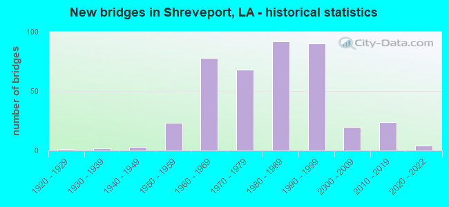
- New bridges - historical statistics
- 11920-1929
- 21930-1939
- 31940-1949
- 231950-1959
- 781960-1969
- 681970-1979
- 921980-1989
- 901990-1999
- 202000-2009
- 242010-2019
- 42020-2022
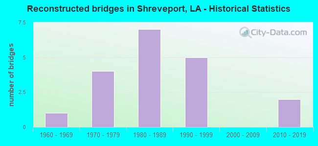
- Reconstructed bridges - Historical Statistics
- 11960-1969
- 41970-1979
- 71980-1989
- 51990-1999
- 02000-2009
- 22010-2019
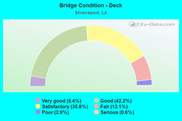
- Bridge Condition - Deck
- 5.4%Very good
- 42.2%Good
- 35.8%Satisfactory
- 13.1%Fair
- 2.9%Poor
- 0.6%Serious
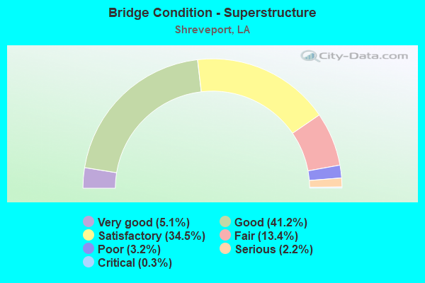
- Bridge Condition - Superstructure
- 5.1%Very good
- 41.2%Good
- 34.5%Satisfactory
- 13.4%Fair
- 3.2%Poor
- 2.2%Serious
- 0.3%Critical
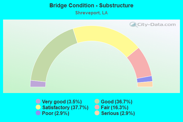
- Bridge Condition - Substructure
- 3.5%Very good
- 36.7%Good
- 37.7%Satisfactory
- 16.3%Fair
- 2.9%Poor
- 2.9%Serious
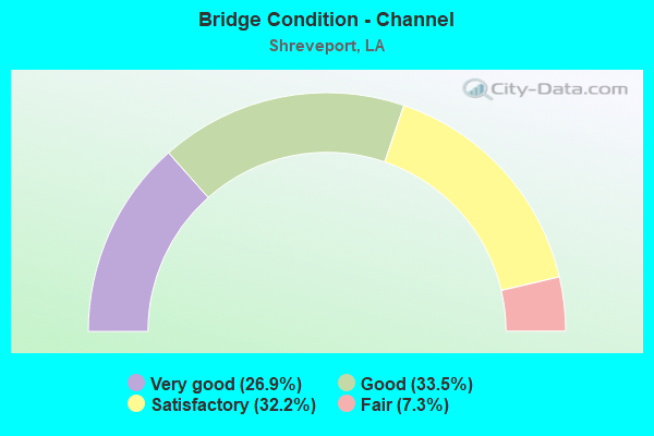
- Bridge Condition - Channel
- 26.9%Very good
- 33.5%Good
- 32.2%Satisfactory
- 7.3%Fair
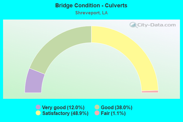
- Bridge Condition - Culverts
- 12.0%Very good
- 38.0%Good
- 48.9%Satisfactory
- 1.1%Fair
Find on map >> Show street view
Structure Number: 40801020300001, Location: 1.0 MI WEST OF US 71 (Lat: 32.458781, Lng: -93.683569), Route carried "on" structure: State highway 511, Year Built: 1968, Status: Open, Structure Length: 86.05m (282.32ft), Average Daily Traffic: 25,600 (year 2018), Truck Traffic: 8%, Average Future Daily Traffic: 13,320 (year 2036), Design Load: HS 20, Features Intersected: RED R.,C.FANT PKWY,AR TE
Minimum Vertical Clearance: 5.18m (16.99ft), Kilometerpoint: 0.261, Lanes on structure: 2, Lanes under structure: 7, Base Highway Network: Yes (Inventory Route: 102-03-1, Subroute: 10), Owner: State Highway Agency, Approaching Roadway Width: 14.6m (47.9ft), Navigation Control: Yes ( Vertical Clearance: 24.7m (81.0ft), Horizontal Clearance: 61.0m (200.1ft)), Material/Design: Steel, Design/Construction: Truss - Thru, Number Of Spans In Main Unit: 3, Number Of Approach Spans: 13, Length of Maximum Span: 121.9m (399.9ft), Curb-To-Curb Width: 9.2m (30.2ft), Out-to-Out Width: 10.2m (33.5ft)
Condition: Deck: Poor, Superstructure: Poor, Substructure: Poor, Channel: Good, Operating Rating: 57.3 metric tons, Method Used To Determine Operating Rating: Load and Resistance Factor Rating (LRFR) rating reported by rating factor(RF) method using HL-93 loadings, Inventory Rating: 34.3 metric tons, Method Used To Determine Inventory Rating: Load and Resistance Factor Rating (LRFR) rating reported by rating factor(RF) method using HL-93 loadings, Structural Evaluation: Meets minimum limits, Deck Geometry: Meets minimum limits, Underclear: Meets minimum limits, Waterway Adequacy: Equal to present desirable criteria, Approach Roadway Alignment: Equal to present desirable criteria, Length Of Structure Improvement: 86.05m (282.32ft), Designated Inspection Frequency: Every 12 months, Critical Feature Inspection Frequency: Every 12 months, Underwater Inspection Frequency: Every 60 months, Inspection Date: July 2021, Critical Feature Inspection Date: July 2021, Underwater Inspection Date: July 2021, Bridge Improvement Cost: $7,339,000, Total Project Cost: $11,008,000 ( Estimate for 2016), Deck Structure Type: Concrete Cast-file-Place
Find on map >> Show street view
Structure Number: 40801080101091, Location: 1.1 MI E OF US 71(LA0612) (Lat: 32.438719, Lng: -93.626800), Route carried "on" structure: State highway 612, Year Built: 1982, Status: Open, Structure Length: 6.95m (22.80ft), Average Daily Traffic: 7,000 (year 2016), Truck Traffic: 22%, Average Future Daily Traffic: 4,380 (year 2036), Design Load: HS 20, Features Intersected: FLAT RIVER
Minimum Vertical Clearance: 30+ m (98+ ft), Kilometerpoint: 1.767, Lanes on structure: 2, Owner: State Highway Agency, Approaching Roadway Width: 10.1m (33.1ft), Material/Design: Concrete, Design/Construction: Slab, Number Of Spans In Main Unit: 10, Length of Maximum Span: 5.8m (19.0ft), Curb-To-Curb Width: 9.9m (32.5ft), Out-to-Out Width: 10.7m (35.1ft)
Condition: Deck: Fair, Superstructure: Fair, Substructure: Satisfactory, Channel: Satisfactory, Operating Rating: 32.1 metric tons, Method Used To Determine Operating Rating: Load and Resistance Factor Rating (LRFR) rating reported by rating factor(RF) method using HL-93 loadings, Inventory Rating: 24.6 metric tons, Method Used To Determine Inventory Rating: Load and Resistance Factor Rating (LRFR) rating reported by rating factor(RF) method using HL-93 loadings, Structural Evaluation: Somewhat better than minimum adequacy, Deck Geometry: Meets minimum limits, Waterway Adequacy: Better than present minimum criteria, Approach Roadway Alignment: Equal to present desirable criteria, Designated Inspection Frequency: Every 24 months, Inspection Date: November 2021, Deck Structure Type: Concrete Precast Panels, Wearing Surface/Protective System: Wearing Surface: Bituminous
Find on map >> Show street view
Structure Number: 40804513100001, Location: .01 MI EAST OF LA 3049 (Lat: 32.556850, Lng: -93.774369), Route carried "on" structure: Interstate 220, Year Built: 1977, Status: Open, Structure Length: 100.65m (330.22ft), Average Daily Traffic: 44,800 (year 2016), Truck Traffic: 19%, Average Future Daily Traffic: 26,820 (year 2036), Design Load: HS 20, Features Intersected: RED RIVER/LA 3049/538
Minimum Vertical Clearance: 30+ m (98+ ft), Kilometerpoint: 0.010, Lanes on structure: 4, Lanes under structure: 4, Base Highway Network: Yes (Inventory Route: 451-31-1, Subroute: 10), Owner: State Highway Agency, Approaching Roadway Width: 40.2m (131.9ft), Skew: 39 degrees, Navigation Control: Yes ( Vertical Clearance: 70.1m (230.0ft), Horizontal Clearance: 25.9m (85.0ft)), Material/Design: Steel continuous, Design/Construction: Girder and Floorbeam System, Number Of Spans In Main Unit: 20, Length of Maximum Span: 83.8m (274.9ft), Curb-To-Curb Width: 24.1m (79.1ft), Out-to-Out Width: 25.7m (84.3ft)
Condition: Deck: Satisfactory, Superstructure: Satisfactory, Substructure: Satisfactory, Channel: Good, Operating Rating: 41.7 metric tons, Method Used To Determine Operating Rating: Load Factor (LF), Inventory Rating: 26.3 metric tons, Method Used To Determine Inventory Rating: Load Factor (LF), Structural Evaluation: Equal to present minimum criteria, Deck Geometry: Superior to present desirable criteria, Underclear: High priority of replacement, Waterway Adequacy: Equal to present desirable criteria, Approach Roadway Alignment: Equal to present desirable criteria, Length Of Structure Improvement: 100.65m (330.22ft), Designated Inspection Frequency: Every 24 months, Underwater Inspection Frequency: Every 60 months, Inspection Date: July 2021, Underwater Inspection Date: July 2017, Bridge Improvement Cost: $16,955,000, Total Project Cost: $25,432,000 ( Estimate for 2016), Deck Structure Type: Concrete Cast-file-Place
Find on map >> Show street view
Structure Number: 40804513102311, Location: 2.31 MI EAST OF LA 3049 (Lat: 32.558011, Lng: -93.735050), Route carried "on" structure: Interstate 220, Year Built: 1978, Status: Open, Structure Length: 3.93m (12.89ft), Average Daily Traffic: 17,800 (year 2016), Truck Traffic: 19%, Average Future Daily Traffic: 12,564 (year 2036), Design Load: HS 20, Features Intersected: VIKING-DRIVE
Minimum Vertical Clearance: 30+ m (98+ ft), Kilometerpoint: 4.513, Lanes on structure: 2, Lanes under structure: 2, Base Highway Network: Yes (Inventory Route: 451-31-1, Subroute: 10), Owner: State Highway Agency, Approaching Roadway Width: 11.6m (38.1ft), Skew: 10 degrees, Material/Design: Concrete continuous, Design/Construction: Slab, Number Of Spans In Main Unit: 3, Length of Maximum Span: 15.2m (49.9ft), Curb-To-Curb Width: 9.1m (29.9ft), Out-to-Out Width: 13.0m (42.7ft)
Condition: Deck: Satisfactory, Superstructure: Satisfactory, Substructure: Satisfactory, Operating Rating: 70.7 metric tons, Method Used To Determine Operating Rating: Load Factor (LF), Inventory Rating: 42.6 metric tons, Method Used To Determine Inventory Rating: Load Factor (LF), Structural Evaluation: Equal to present minimum criteria, Deck Geometry: High priority of replacement, Underclear: Better than present minimum criteria, Approach Roadway Alignment: Equal to present desirable criteria, Length Of Structure Improvement: 4.85m (15.91ft), Designated Inspection Frequency: Every 24 months, Inspection Date: November 2021, Bridge Improvement Cost: $413,000, Total Project Cost: $619,000 ( Estimate for 2016), Deck Structure Type: Concrete Cast-file-Place
Find on map >> Show street view
Structure Number: 40804513102312, Location: 2.31 MI EAST OF LA 3049 (Lat: 32.558319, Lng: -93.734711), Route carried "on" structure: Interstate 220, Year Built: 1978, Status: Open, Structure Length: 3.93m (12.89ft), Average Daily Traffic: 17,800 (year 2016), Truck Traffic: 19%, Average Future Daily Traffic: 12,564 (year 2036), Design Load: HS 20, Features Intersected: VIKING-DRIVE
Minimum Vertical Clearance: 30+ m (98+ ft), Kilometerpoint: 11.038, Lanes on structure: 2, Lanes under structure: 2, Base Highway Network: Yes (Inventory Route: 451-31-2, Subroute: 10), Owner: State Highway Agency, Approaching Roadway Width: 11.6m (38.1ft), Skew: 10 degrees, Material/Design: Concrete continuous, Design/Construction: Slab, Number Of Spans In Main Unit: 3, Length of Maximum Span: 15.2m (49.9ft), Curb-To-Curb Width: 12.2m (40.0ft), Out-to-Out Width: 13.0m (42.7ft)
Condition: Deck: Satisfactory, Superstructure: Satisfactory, Substructure: Satisfactory, Operating Rating: 70.7 metric tons, Method Used To Determine Operating Rating: Load Factor (LF), Inventory Rating: 42.6 metric tons, Method Used To Determine Inventory Rating: Load Factor (LF), Structural Evaluation: Equal to present minimum criteria, Deck Geometry: Better than present minimum criteria, Underclear: Equal to present minimum criteria, Approach Roadway Alignment: Equal to present desirable criteria, Designated Inspection Frequency: Every 24 months, Inspection Date: November 2021, Deck Structure Type: Concrete Cast-file-Place
Find on map >> Show street view
Structure Number: 40804513102511, Location: 2.51 MI EAST OF LA 3049 (Lat: 32.558589, Lng: -93.731600), Route carried "on" structure: Interstate 220, Year Built: 1978, Status: Open, Structure Length: 9.72m (31.89ft), Average Daily Traffic: 17,800 (year 2016), Truck Traffic: 19%, Average Future Daily Traffic: 12,564 (year 2036), Design Load: HS 20, Features Intersected: ST.LOUIS-S.W.R.R.
Minimum Vertical Clearance: 30+ m (98+ ft), Kilometerpoint: 4.064, Lanes on structure: 2, Base Highway Network: Yes (Inventory Route: 451-31-1, Subroute: 10), Owner: State Highway Agency, Approaching Roadway Width: 11.6m (38.1ft), Skew: 10 degrees, Material/Design: Prestressed concrete, Design/Construction: Stringer/Multi-beam, Number Of Spans In Main Unit: 4, Length of Maximum Span: 29.6m (97.1ft), Curb-To-Curb Width: 12.2m (40.0ft), Out-to-Out Width: 13.0m (42.7ft)
Condition: Deck: Satisfactory, Superstructure: Satisfactory, Substructure: Satisfactory, Operating Rating: 73.5 metric tons, Method Used To Determine Operating Rating: Load Factor (LF), Inventory Rating: 34.5 metric tons, Method Used To Determine Inventory Rating: Load Factor (LF), Structural Evaluation: Equal to present minimum criteria, Deck Geometry: Better than present minimum criteria, Underclear: Equal to present desirable criteria, Approach Roadway Alignment: Equal to present desirable criteria, Designated Inspection Frequency: Every 24 months, Inspection Date: November 2021, Deck Structure Type: Concrete Cast-file-Place
Find on map >> Show street view
Structure Number: 40804513102512, Location: 2.51 MI EAST OF LA 3049 (Lat: 32.558811, Lng: -93.730600), Route carried "on" structure: Interstate 220, Year Built: 1978, Status: Open, Structure Length: 9.42m (30.91ft), Average Daily Traffic: 17,800 (year 2016), Truck Traffic: 19%, Average Future Daily Traffic: 12,564 (year 2036), Design Load: HS 20, Features Intersected: ST.LOUIS-S.W.R.R.
Minimum Vertical Clearance: 30+ m (98+ ft), Kilometerpoint: 11.479, Lanes on structure: 3, Base Highway Network: Yes (Inventory Route: 451-31-2, Subroute: 10), Owner: State Highway Agency, Approaching Roadway Width: 19.2m (63.0ft), Skew: 10 degrees, Material/Design: Prestressed concrete, Design/Construction: Stringer/Multi-beam, Number Of Spans In Main Unit: 4, Length of Maximum Span: 25.9m (85.0ft), Curb-To-Curb Width: 15.9m (52.2ft), Out-to-Out Width: 16.7m (54.8ft)
Condition: Deck: Satisfactory, Superstructure: Satisfactory, Substructure: Satisfactory, Operating Rating: 74.4 metric tons, Method Used To Determine Operating Rating: Load Factor (LF), Inventory Rating: 37.2 metric tons, Method Used To Determine Inventory Rating: Load Factor (LF), Structural Evaluation: Equal to present minimum criteria, Deck Geometry: Somewhat better than minimum adequacy, Underclear: Superior to present desirable criteria, Approach Roadway Alignment: Equal to present desirable criteria, Designated Inspection Frequency: Every 24 months, Inspection Date: November 2021, Deck Structure Type: Concrete Cast-file-Place
Find on map >> Show street view
Structure Number: 40804513102791, Location: I-220 OVER LA 3 (Lat: 32.557769, Lng: -93.726900), Route carried "on" structure: Interstate 220, Year Built: 1978, Status: Open, Structure Length: 8.50m (27.89ft), Average Daily Traffic: 17,800 (year 2016), Truck Traffic: 19%, Average Future Daily Traffic: 12,564 (year 2036), Design Load: HS 20, Features Intersected: BENTON-ROAD/LA 3
Minimum Vertical Clearance: 30+ m (98+ ft), Kilometerpoint: 4.517, Lanes on structure: 2, Lanes under structure: 4, Base Highway Network: Yes (Inventory Route: 451-31-1, Subroute: 10), Owner: State Highway Agency, Approaching Roadway Width: 11.6m (38.1ft), Skew: 13 degrees, Material/Design: Prestressed concrete, Design/Construction: Stringer/Multi-beam, Number Of Spans In Main Unit: 4, Length of Maximum Span: 26.2m (86.0ft), Curb-To-Curb Width: 12.1m (39.7ft), Out-to-Out Width: 13.0m (42.7ft)
Condition: Deck: Satisfactory, Superstructure: Satisfactory, Substructure: Satisfactory, Operating Rating: 82.5 metric tons, Method Used To Determine Operating Rating: Load Factor (LF), Inventory Rating: 39.9 metric tons, Method Used To Determine Inventory Rating: Load Factor (LF), Structural Evaluation: Equal to present minimum criteria, Deck Geometry: Equal to present minimum criteria, Underclear: Somewhat better than minimum adequacy, Approach Roadway Alignment: Equal to present desirable criteria, Designated Inspection Frequency: Every 24 months, Inspection Date: November 2021, Deck Structure Type: Concrete Cast-file-Place
Find on map >> Show street view
Structure Number: 40804513102792, Location: I-220 OVER LA 3 (Lat: 32.557831, Lng: -93.726100), Route carried "on" structure: Interstate 220, Year Built: 1978, Status: Open, Structure Length: 8.50m (27.89ft), Average Daily Traffic: 17,800 (year 2016), Truck Traffic: 19%, Average Future Daily Traffic: 12,564 (year 2036), Design Load: HS 20, Features Intersected: BENTON-ROAD/LA 3
Minimum Vertical Clearance: 30+ m (98+ ft), Kilometerpoint: 11.043, Lanes on structure: 2, Lanes under structure: 4, Base Highway Network: Yes (Inventory Route: 451-31-2, Subroute: 10), Owner: State Highway Agency, Approaching Roadway Width: 11.6m (38.1ft), Skew: 13 degrees, Material/Design: Prestressed concrete, Design/Construction: Stringer/Multi-beam, Number Of Spans In Main Unit: 4, Length of Maximum Span: 26.2m (86.0ft), Curb-To-Curb Width: 12.1m (39.7ft), Out-to-Out Width: 13.0m (42.7ft)
Condition: Deck: Satisfactory, Superstructure: Satisfactory, Substructure: Satisfactory, Operating Rating: 82.5 metric tons, Method Used To Determine Operating Rating: Load Factor (LF), Inventory Rating: 39.9 metric tons, Method Used To Determine Inventory Rating: Load Factor (LF), Structural Evaluation: Equal to present minimum criteria, Deck Geometry: Equal to present minimum criteria, Underclear: Equal to present minimum criteria, Approach Roadway Alignment: Equal to present desirable criteria, Designated Inspection Frequency: Every 24 months, Inspection Date: November 2021, Deck Structure Type: Concrete Cast-file-Place
Find on map >> Show street view
Structure Number: 40804513104461, Location: .7 MI EAST OF LA 3105 (Lat: 32.557000, Lng: -93.698200), Route carried "on" structure: Interstate 220, Year Built: 1978, Status: Open, Structure Length: 1.31m (4.30ft), Average Daily Traffic: 18,850 (year 2016), Truck Traffic: 19%, Average Future Daily Traffic: 12,744 (year 2036), Design Load: HS 20, Features Intersected: BAYOU
Minimum Vertical Clearance: 30+ m (98+ ft), Kilometerpoint: 7.226, Lanes on structure: 2, Base Highway Network: Yes (Inventory Route: 451-31-1, Subroute: 10), Owner: State Highway Agency, Approaching Roadway Width: 11.6m (38.1ft), Skew: 17 degrees, Material/Design: Concrete, Design/Construction: Culvert, Number Of Spans In Main Unit: 4, Length of Maximum Span: 2.1m (6.9ft), Curb-To-Curb Width: 11.6m (38.1ft), Out-to-Out Width: 37.8m (124.0ft)
Condition: Channel: Good, Culverts: Satisfactory, Operating Rating: 42.1 metric tons, Method Used To Determine Operating Rating: Load and Resistance Factor Rating (LRFR) rating reported by rating factor(RF) method using HL-93 loadings, Inventory Rating: 32.4 metric tons, Method Used To Determine Inventory Rating: Load and Resistance Factor Rating (LRFR) rating reported by rating factor(RF) method using HL-93 loadings, Structural Evaluation: Equal to present minimum criteria, Deck Geometry: Equal to present minimum criteria, Waterway Adequacy: Better than present minimum criteria, Approach Roadway Alignment: Equal to present desirable criteria, Designated Inspection Frequency: Every 24 months, Inspection Date: November 2021, Deck Structure Type: Concrete Cast-file-Place
Find on map >> Show street view
Structure Number: 40804513104462, Location: .7 MI EAST OF LA 3105 (Lat: 32.557539, Lng: -93.698800), Route carried "on" structure: Interstate 220, Year Built: 1978, Status: Open, Structure Length: 1.31m (4.30ft), Average Daily Traffic: 18,850 (year 2016), Truck Traffic: 19%, Average Future Daily Traffic: 12,744 (year 2036), Design Load: HS 20, Features Intersected: BAYOU
Minimum Vertical Clearance: 30+ m (98+ ft), Kilometerpoint: 8.470, Lanes on structure: 2, Base Highway Network: Yes (Inventory Route: 451-31-2, Subroute: 10), Owner: State Highway Agency, Approaching Roadway Width: 11.6m (38.1ft), Skew: 17 degrees, Material/Design: Concrete, Design/Construction: Culvert, Number Of Spans In Main Unit: 4, Length of Maximum Span: 2.1m (6.9ft), Curb-To-Curb Width: 11.6m (38.1ft), Out-to-Out Width: 37.8m (124.0ft)
Condition: Channel: Good, Culverts: Satisfactory, Operating Rating: 42.1 metric tons, Method Used To Determine Operating Rating: Load and Resistance Factor Rating (LRFR) rating reported by rating factor(RF) method using HL-93 loadings, Inventory Rating: 32.4 metric tons, Method Used To Determine Inventory Rating: Load and Resistance Factor Rating (LRFR) rating reported by rating factor(RF) method using HL-93 loadings, Structural Evaluation: Equal to present minimum criteria, Deck Geometry: Equal to present minimum criteria, Waterway Adequacy: Better than present minimum criteria, Approach Roadway Alignment: Equal to present desirable criteria, Designated Inspection Frequency: Every 24 months, Inspection Date: November 2021, Deck Structure Type: Concrete Cast-file-Place
Find on map >> Show street view
Structure Number: 40804513104791, Location: 1.0 MI EAST OF LA 3105 (Lat: 32.557339, Lng: -93.692800), Route carried "on" structure: Interstate 220, Year Built: 1978, Status: Open, Structure Length: 0.98m (3.22ft), Average Daily Traffic: 18,850 (year 2016), Truck Traffic: 19%, Average Future Daily Traffic: 12,744 (year 2036), Design Load: HS 20, Features Intersected: BENOIT BAYOU
Minimum Vertical Clearance: 30+ m (98+ ft), Kilometerpoint: 7.731, Lanes on structure: 2, Base Highway Network: Yes (Inventory Route: 451-31-1, Subroute: 10), Owner: State Highway Agency, Approaching Roadway Width: 11.6m (38.1ft), Skew: 14 degrees, Material/Design: Concrete, Design/Construction: Culvert, Number Of Spans In Main Unit: 2, Length of Maximum Span: 3.0m (9.8ft), Curb-To-Curb Width: 11.6m (38.1ft), Out-to-Out Width: 45.1m (148.0ft)
Condition: Channel: Good, Culverts: Good, Operating Rating: 42.1 metric tons, Method Used To Determine Operating Rating: Load and Resistance Factor Rating (LRFR) rating reported by rating factor(RF) method using HL-93 loadings, Inventory Rating: 32.4 metric tons, Method Used To Determine Inventory Rating: Load and Resistance Factor Rating (LRFR) rating reported by rating factor(RF) method using HL-93 loadings, Structural Evaluation: Better than present minimum criteria, Deck Geometry: Equal to present minimum criteria, Waterway Adequacy: Better than present minimum criteria, Approach Roadway Alignment: Equal to present desirable criteria, Designated Inspection Frequency: Every 24 months, Inspection Date: November 2021, Deck Structure Type: Concrete Cast-file-Place
Find on map >> Show street view
Structure Number: 40804513104792, Location: 1.0 MI EAST OF LA 3105 (Lat: 32.557950, Lng: -93.692900), Route carried "on" structure: Interstate 220, Year Built: 1978, Status: Open, Structure Length: 0.98m (3.22ft), Average Daily Traffic: 18,850 (year 2016), Truck Traffic: 19%, Average Future Daily Traffic: 12,744 (year 2036), Design Load: HS 20, Features Intersected: BENOIT BAYOU
Minimum Vertical Clearance: 30+ m (98+ ft), Kilometerpoint: 7.918, Lanes on structure: 2, Base Highway Network: Yes (Inventory Route: 451-31-2, Subroute: 10), Owner: State Highway Agency, Approaching Roadway Width: 11.6m (38.1ft), Skew: 14 degrees, Material/Design: Concrete, Design/Construction: Culvert, Number Of Spans In Main Unit: 2, Length of Maximum Span: 3.0m (9.8ft), Curb-To-Curb Width: 11.6m (38.1ft), Out-to-Out Width: 39.9m (130.9ft)
Condition: Channel: Good, Culverts: Good, Operating Rating: 42.1 metric tons, Method Used To Determine Operating Rating: Load and Resistance Factor Rating (LRFR) rating reported by rating factor(RF) method using HL-93 loadings, Inventory Rating: 32.4 metric tons, Method Used To Determine Inventory Rating: Load and Resistance Factor Rating (LRFR) rating reported by rating factor(RF) method using HL-93 loadings, Structural Evaluation: Better than present minimum criteria, Deck Geometry: Equal to present minimum criteria, Waterway Adequacy: Better than present minimum criteria, Approach Roadway Alignment: Equal to present desirable criteria, Designated Inspection Frequency: Every 24 months, Inspection Date: November 2021, Deck Structure Type: Concrete Cast-file-Place
Find on map >> Show street view
Structure Number: 40804513105611, Location: 1.9 MI EAST OF LA 3105 (Lat: 32.557489, Lng: -93.678800), Route carried "on" structure: Interstate 220, Year Built: 1978, Status: Open, Structure Length: 7.32m (24.02ft), Average Daily Traffic: 14,300 (year 2016), Truck Traffic: 19%, Average Future Daily Traffic: 10,908 (year 2036), Design Load: HS 20, Features Intersected: SWAN LAKE ROAD
Minimum Vertical Clearance: 30+ m (98+ ft), Kilometerpoint: 9.043, Lanes on structure: 2, Lanes under structure: 2, Base Highway Network: Yes (Inventory Route: 451-31-1, Subroute: 10), Owner: State Highway Agency, Approaching Roadway Width: 11.6m (38.1ft), Skew: 17 degrees, Material/Design: Prestressed concrete, Design/Construction: Stringer/Multi-beam, Number Of Spans In Main Unit: 4, Length of Maximum Span: 20.7m (67.9ft), Curb-To-Curb Width: 12.1m (39.7ft), Out-to-Out Width: 13.0m (42.7ft)
Condition: Deck: Good, Superstructure: Good, Substructure: Good, Operating Rating: 70.7 metric tons, Method Used To Determine Operating Rating: Load Factor (LF), Inventory Rating: 32.7 metric tons, Method Used To Determine Inventory Rating: Load Factor (LF), Structural Evaluation: Better than present minimum criteria, Deck Geometry: Equal to present minimum criteria, Underclear: Superior to present desirable criteria, Approach Roadway Alignment: Equal to present desirable criteria, Designated Inspection Frequency: Every 24 months, Inspection Date: November 2021, Deck Structure Type: Concrete Cast-file-Place
Find on map >> Show street view
Structure Number: 40804513105612, Location: 1.9 MI EAST OF LA 3105 (Lat: 32.558089, Lng: -93.678200), Route carried "on" structure: Interstate 220, Year Built: 1978, Status: Open, Structure Length: 7.32m (24.02ft), Average Daily Traffic: 18,850 (year 2016), Truck Traffic: 19%, Average Future Daily Traffic: 12,744 (year 2036), Design Load: HS 20, Features Intersected: SWAN LAKE ROAD
Minimum Vertical Clearance: 30+ m (98+ ft), Kilometerpoint: 6.536, Lanes on structure: 2, Lanes under structure: 2, Base Highway Network: Yes (Inventory Route: 451-31-2, Subroute: 10), Owner: State Highway Agency, Approaching Roadway Width: 11.6m (38.1ft), Skew: 17 degrees, Material/Design: Prestressed concrete, Design/Construction: Stringer/Multi-beam, Number Of Spans In Main Unit: 4, Length of Maximum Span: 20.7m (67.9ft), Curb-To-Curb Width: 12.1m (39.7ft), Out-to-Out Width: 13.0m (42.7ft)
Condition: Deck: Satisfactory, Superstructure: Satisfactory, Substructure: Satisfactory, Operating Rating: 70.7 metric tons, Method Used To Determine Operating Rating: Load Factor (LF), Inventory Rating: 32.7 metric tons, Method Used To Determine Inventory Rating: Load Factor (LF), Structural Evaluation: Equal to present minimum criteria, Deck Geometry: Equal to present minimum criteria, Underclear: Superior to present desirable criteria, Approach Roadway Alignment: Equal to present desirable criteria, Designated Inspection Frequency: Every 24 months, Inspection Date: November 2021, Deck Structure Type: Concrete Cast-file-Place
Find on map >> Show street view
Structure Number: 40900000000155, Location: 0.6 MI S OF LA 169 (Lat: 32.357961, Lng: -93.966439), Route carried "on" structure: County highway , Year Built: 2019, Status: Open, Structure Length: 3.66m (12.01ft), Average Daily Traffic: 120 (year 2019), Average Future Daily Traffic: 1,220 (year 2025), Design Load: Greater than HL93, Features Intersected: BOGGY BAYOU, Facility Carried by Structure: PROVIDENCE ROAD
Minimum Vertical Clearance: 30+ m (98+ ft), Kilometerpoint: 1.019, Lanes on structure: 2, Owner: County Highway Agency, Approaching Roadway Width: 6.2m (20.3ft), Material/Design: Concrete, Design/Construction: Slab, Number Of Spans In Main Unit: 6, Length of Maximum Span: 6.1m (20.0ft), Curb-To-Curb Width: 8.4m (27.6ft), Out-to-Out Width: 9.4m (30.8ft)
Condition: Deck: Very good, Superstructure: Very good, Substructure: Very good, Channel: Very good, Operating Rating: 57.7 metric tons, Method Used To Determine Operating Rating: Load and Resistance Factor Rating (LRFR) rating reported by rating factor(RF) method using HL-93 loadings, Inventory Rating: 44.4 metric tons, Method Used To Determine Inventory Rating: Load and Resistance Factor Rating (LRFR) rating reported by rating factor(RF) method using HL-93 loadings, Structural Evaluation: Equal to present desirable criteria, Deck Geometry: Somewhat better than minimum adequacy, Waterway Adequacy: Equal to present desirable criteria, Approach Roadway Alignment: Equal to present desirable criteria, Designated Inspection Frequency: Every 24 months, Inspection Date: March 2021, Deck Structure Type: Concrete Precast Panels
Find on map >> Show street view
Structure Number: 40900000040256, Location: 0.15 MILES EAST OF LINWOO (Lat: 32.356911, Lng: -93.763169), Route carried "on" structure: County highway , Year Built: 2009, Status: Open, Structure Length: 4.27m (14.01ft), Average Daily Traffic: 6,000 (year 2005), Average Future Daily Traffic: 7,080 (year 2036), Design Load: HS 20, Features Intersected: TRIB TO BOGGY BAYOU, Facility Carried by Structure: SOUTHERN LOOP
Minimum Vertical Clearance: 30+ m (98+ ft), Kilometerpoint: 0.000, Lanes on structure: 2, Owner: City or Municipal Highway Agency, Approaching Roadway Width: 7.3m (24.0ft), Skew: 30 degrees, Material/Design: Concrete, Design/Construction: Slab, Number Of Spans In Main Unit: 7, Length of Maximum Span: 6.1m (20.0ft), Curb-To-Curb Width: 12.0m (39.4ft), Out-to-Out Width: 12.9m (42.3ft)
Condition: Deck: Good, Superstructure: Good, Substructure: Good, Channel: Very good, Operating Rating: 39.9 metric tons, Method Used To Determine Operating Rating: Load and Resistance Factor Rating (LRFR) rating reported by rating factor(RF) method using HL-93 loadings, Inventory Rating: 30.8 metric tons, Method Used To Determine Inventory Rating: Load and Resistance Factor Rating (LRFR) rating reported by rating factor(RF) method using HL-93 loadings, Structural Evaluation: Better than present minimum criteria, Deck Geometry: Somewhat better than minimum adequacy, Waterway Adequacy: Equal to present desirable criteria, Approach Roadway Alignment: Equal to present desirable criteria, Designated Inspection Frequency: Every 24 months, Underwater Inspection Frequency: Every 60 months, Inspection Date: March 2021, Underwater Inspection Date: June 2020, Deck Structure Type: Concrete Cast-file-Place, Wearing Surface/Protective System: Wearing Surface: Monolithic Concrete
Find on map >> Show street view
Structure Number: 40900000040273, Location: 0.83 MI SW OF US 71 (Lat: 32.544450, Lng: -93.789000), Route carried "on" structure: Interstate 220, Year Built: 2010, Status: Open, Structure Length: 3.32m (10.89ft), Average Daily Traffic: 71,600 (year 2016), Truck Traffic: 19%, Average Future Daily Traffic: 80,476 (year 2036), Design Load: HS 20, Features Intersected: MCCAIN CREEK
Minimum Vertical Clearance: 30+ m (98+ ft), Kilometerpoint: 11.269, Lanes on structure: 4, Base Highway Network: Yes (Inventory Route: 451-30-1, Subroute: 10), Owner: State Highway Agency, Approaching Roadway Width: 11.6m (38.1ft), Skew: 35 degrees, Material/Design: Concrete, Design/Construction: Culvert, Number Of Spans In Main Unit: 4, Length of Maximum Span: 4.6m (15.1ft)
Condition: Channel: Very good, Culverts: Good, Operating Rating: 42.1 metric tons, Method Used To Determine Operating Rating: Load and Resistance Factor Rating (LRFR) rating reported by rating factor(RF) method using HL-93 loadings, Inventory Rating: 32.4 metric tons, Method Used To Determine Inventory Rating: Load and Resistance Factor Rating (LRFR) rating reported by rating factor(RF) method using HL-93 loadings, Structural Evaluation: Better than present minimum criteria, Waterway Adequacy: Equal to present desirable criteria, Approach Roadway Alignment: Equal to present desirable criteria, Designated Inspection Frequency: Every 24 months, Inspection Date: Febuary 2022, Deck Structure Type: Concrete Cast-file-Place
Find on map >> Show street view
Structure Number: 40900000040278, Location: 0.7 MILES EAST OF LA 526 (Lat: 32.442311, Lng: -93.889000), Route carried "on" structure: State highway 511, Year Built: 2011, Status: Open, Structure Length: 0.76m (2.49ft), Average Daily Traffic: 11,700 (year 2016), Truck Traffic: 10%, Average Future Daily Traffic: 13,806 (year 2036), Design Load: HS 20, Features Intersected: CREEK
Minimum Vertical Clearance: 30+ m (98+ ft), Kilometerpoint: 5.948, Lanes on structure: 5, Owner: State Highway Agency, Approaching Roadway Width: 19.5m (64.0ft), Skew: 30 degrees, Material/Design: Concrete, Design/Construction: Culvert, Number Of Spans In Main Unit: 4, Length of Maximum Span: 1.8m (5.9ft)
Condition: Channel: Good, Culverts: Very good, Operating Rating: 42.1 metric tons, Method Used To Determine Operating Rating: Load and Resistance Factor Rating (LRFR) rating reported by rating factor(RF) method using HL-93 loadings, Inventory Rating: 32.4 metric tons, Method Used To Determine Inventory Rating: Load and Resistance Factor Rating (LRFR) rating reported by rating factor(RF) method using HL-93 loadings, Structural Evaluation: Equal to present desirable criteria, Waterway Adequacy: Equal to present desirable criteria, Approach Roadway Alignment: Equal to present desirable criteria, Designated Inspection Frequency: Every 24 months, Inspection Date: January 2021, Deck Structure Type: Concrete Cast-file-Place
Find on map >> Show street view
Structure Number: 40900000040286, Location: 0.8 MI W OF JCT LA 1 (Lat: 32.400939, Lng: -93.707500), Route carried "on" structure: State highway 523, Year Built: 2011, Status: Open, Structure Length: 5.49m (18.01ft), Average Daily Traffic: 9,500 (year 2016), Truck Traffic: 8%, Average Future Daily Traffic: 11,210 (year 2036), Design Load: HS 20, Features Intersected: SAND BEACH BAYOU
Minimum Vertical Clearance: 30+ m (98+ ft), Kilometerpoint: 8.105, Lanes on structure: 4, Base Highway Network: Yes (Inventory Route: 103-01-1, Subroute: 10), Owner: State Highway Agency, Approaching Roadway Width: 21.3m (69.9ft), Skew: 30 degrees, Material/Design: Concrete, Design/Construction: Slab, Number Of Spans In Main Unit: 9, Length of Maximum Span: 6.1m (20.0ft), Curb-To-Curb Width: 21.2m (69.6ft), Out-to-Out Width: 22.1m (72.5ft)
Condition: Deck: Good, Superstructure: Good, Substructure: Very good, Channel: Good, Operating Rating: 53.8 metric tons, Method Used To Determine Operating Rating: Load and Resistance Factor Rating (LRFR) rating reported by rating factor(RF) method using HL-93 loadings, Inventory Rating: 41.5 metric tons, Method Used To Determine Inventory Rating: Load and Resistance Factor Rating (LRFR) rating reported by rating factor(RF) method using HL-93 loadings, Structural Evaluation: Better than present minimum criteria, Deck Geometry: Superior to present desirable criteria, Waterway Adequacy: Equal to present desirable criteria, Approach Roadway Alignment: Equal to present desirable criteria, Designated Inspection Frequency: Every 24 months, Inspection Date: Febuary 2021, Deck Structure Type: Concrete Cast-file-Place, Wearing Surface/Protective System: Wearing Surface: Monolithic Concrete
Find on map >> Show street view
Structure Number: 40900000040292, Location: 1.82 W. OF JCT OF LA1 (Lat: 32.396911, Lng: -93.723300), Route carried "on" structure: State highway 523, Year Built: 2011, Status: Open, Structure Length: 6.10m (20.01ft), Average Daily Traffic: 9,500 (year 2016), Truck Traffic: 10%, Average Future Daily Traffic: 11,210 (year 2036), Design Load: HS 20, Features Intersected: BAYOU PIERRE
Minimum Vertical Clearance: 30+ m (98+ ft), Kilometerpoint: 6.479, Lanes on structure: 4, Owner: State Highway Agency, Approaching Roadway Width: 21.3m (69.9ft), Skew: 30 degrees, Material/Design: Concrete, Design/Construction: Slab, Number Of Spans In Main Unit: 10, Length of Maximum Span: 6.1m (20.0ft), Curb-To-Curb Width: 21.4m (70.2ft), Out-to-Out Width: 22.4m (73.5ft)
Condition: Deck: Good, Superstructure: Good, Substructure: Good, Channel: Satisfactory, Operating Rating: 50.9 metric tons, Method Used To Determine Operating Rating: Load and Resistance Factor Rating (LRFR) rating reported by rating factor(RF) method using HL-93 loadings, Inventory Rating: 39.2 metric tons, Method Used To Determine Inventory Rating: Load and Resistance Factor Rating (LRFR) rating reported by rating factor(RF) method using HL-93 loadings, Structural Evaluation: Better than present minimum criteria, Deck Geometry: Superior to present desirable criteria, Waterway Adequacy: Equal to present desirable criteria, Approach Roadway Alignment: Equal to present desirable criteria, Designated Inspection Frequency: Every 24 months, Inspection Date: Febuary 2021, Deck Structure Type: Concrete Cast-file-Place, Wearing Surface/Protective System: Wearing Surface: Monolithic Concrete
Find on map >> Show street view
Structure Number: 40900000040297, Location: 0.82 MI SOUTH OF LA 1 (Lat: 32.582831, Lng: -93.829531), Route carried "on" structure: Interstate 49, Year Built: 2016, Status: Open, Structure Length: 24.02m (78.81ft), Average Daily Traffic: 5,150 (year 2016), Truck Traffic: 19%, Average Future Daily Traffic: 26,314 (year 2036), Design Load: HL 93, Features Intersected: PINEHILL RD
Minimum Vertical Clearance: 30+ m (98+ ft), Kilometerpoint: 6.753, Lanes on structure: 2, Lanes under structure: 2, Base Highway Network: Yes (Inventory Route: 455-09-1, Subroute: 10), Owner: State Highway Agency, Approaching Roadway Width: 12.2m (40.0ft), Skew: 30 degrees, Material/Design: Prestressed concrete continuous, Design/Construction: Stringer/Multi-beam, Number Of Spans In Main Unit: 9, Length of Maximum Span: 27.4m (89.9ft), Curb-To-Curb Width: 12.1m (39.7ft), Out-to-Out Width: 12.9m (42.3ft)
Condition: Deck: Very good, Superstructure: Very good, Substructure: Good, Operating Rating: 56.4 metric tons, Method Used To Determine Operating Rating: Load and Resistance Factor Rating (LRFR) rating reported by rating factor(RF) method using HL-93 loadings, Inventory Rating: 43.4 metric tons, Method Used To Determine Inventory Rating: Load and Resistance Factor Rating (LRFR) rating reported by rating factor(RF) method using HL-93 loadings, Structural Evaluation: Better than present minimum criteria, Deck Geometry: Equal to present minimum criteria, Approach Roadway Alignment: Equal to present desirable criteria, Designated Inspection Frequency: Every 24 months, Inspection Date: June 2020, Deck Structure Type: Concrete Cast-file-Place, Wearing Surface/Protective System: Wearing Surface: Monolithic Concrete
Find on map >> Show street view
Structure Number: 40900000040325, Location: 0.3 MI. N. OF LA 3194 (Lat: 32.554019, Lng: -93.793519), Route carried "on" structure: Interstate 49, Year Built: 2016, Status: Open, Structure Length: 2.04m (6.69ft), Average Daily Traffic: 2,869 (year 2013), Truck Traffic: 15%, Average Future Daily Traffic: 3,345 (year 2033), Design Load: Greater than HL93, Features Intersected: MCCAIN CREEK
Minimum Vertical Clearance: 30+ m (98+ ft), Kilometerpoint: 2.826, Lanes on structure: 4, Owner: State Highway Agency, Approaching Roadway Width: 12.2m (40.0ft), Skew: 13 degrees, Material/Design: Concrete, Design/Construction: Culvert, Number Of Spans In Main Unit: 4, Length of Maximum Span: 4.6m (15.1ft), Curb-To-Curb Width: 12.2m (40.0ft), Out-to-Out Width: 173.1m (567.9ft)
Condition: Channel: Very good, Culverts: Good, Operating Rating: 71.9 metric tons, Method Used To Determine Operating Rating: Load and Resistance Factor Rating (LRFR) rating reported by rating factor(RF) method using HL-93 loadings, Inventory Rating: 55.4 metric tons, Method Used To Determine Inventory Rating: Load and Resistance Factor Rating (LRFR) rating reported by rating factor(RF) method using HL-93 loadings, Structural Evaluation: Better than present minimum criteria, Deck Geometry: High priority of replacement, Waterway Adequacy: Equal to present desirable criteria, Approach Roadway Alignment: Equal to present desirable criteria, Designated Inspection Frequency: Every 24 months, Inspection Date: Febuary 2022
Find on map >> Show street view
Structure Number: 40900000040326, Location: 0.27 MI. N OF LA 3194 (Lat: 32.553381, Lng: -93.793561), Route carried "on" structure: Interstate 49, Year Built: 2016, Status: Open, Structure Length: 0.76m (2.49ft), Average Daily Traffic: 10,300 (year 2016), Truck Traffic: 19%, Average Future Daily Traffic: 33,456 (year 2033), Design Load: Greater than HL93, Features Intersected: MCCAIN CREEK TRIB.
Minimum Vertical Clearance: 30+ m (98+ ft), Kilometerpoint: 2.749, Lanes on structure: 4, Base Highway Network: Yes (Inventory Route: 455-09-1, Subroute: 10), Owner: State Highway Agency, Approaching Roadway Width: 12.2m (40.0ft), Skew: 16 degrees, Material/Design: Concrete, Design/Construction: Culvert, Number Of Spans In Main Unit: 2, Length of Maximum Span: 3.0m (9.8ft), Curb-To-Curb Width: 12.2m (40.0ft), Out-to-Out Width: 129.2m (423.9ft)
Condition: Channel: Good, Culverts: Satisfactory, Operating Rating: 97.2 metric tons, Method Used To Determine Operating Rating: Load and Resistance Factor Rating (LRFR) rating reported by rating factor(RF) method using HL-93 loadings, Inventory Rating: 74.5 metric tons, Method Used To Determine Inventory Rating: Load and Resistance Factor Rating (LRFR) rating reported by rating factor(RF) method using HL-93 loadings, Structural Evaluation: Equal to present minimum criteria, Deck Geometry: High priority of replacement, Waterway Adequacy: Equal to present desirable criteria, Approach Roadway Alignment: Equal to present desirable criteria, Designated Inspection Frequency: Every 24 months, Inspection Date: Febuary 2022
Find on map >> Show street view
Structure Number: 40900000040327, Location: .52 MI N. OF LA 3194 (Lat: 32.553450, Lng: -93.795611), Route carried "on" structure: Interstate 49, Year Built: 2016, Status: Open, Structure Length: 0.76m (2.49ft), Average Daily Traffic: 5,150 (year 2016), Truck Traffic: 19%, Average Future Daily Traffic: 3,456 (year 2033), Design Load: Greater than HL93, Features Intersected: TRIB. TO MCCAIN CREEK
Minimum Vertical Clearance: 30+ m (98+ ft), Kilometerpoint: 0.678, Lanes on structure: 1, Base Highway Network: Yes (Inventory Route: 455-09-1, Subroute: 10), Owner: State Highway Agency, Approaching Roadway Width: 8.2m (26.9ft), Skew: 2 degrees, Material/Design: Concrete, Design/Construction: Culvert, Number Of Spans In Main Unit: 2, Length of Maximum Span: 3.7m (12.1ft), Curb-To-Curb Width: 8.2m (26.9ft), Out-to-Out Width: 78.9m (258.9ft)
Condition: Channel: Very good, Culverts: Very good, Operating Rating: 97.2 metric tons, Method Used To Determine Operating Rating: Load and Resistance Factor Rating (LRFR) rating reported by rating factor(RF) method using HL-93 loadings, Inventory Rating: 74.5 metric tons, Method Used To Determine Inventory Rating: Load and Resistance Factor Rating (LRFR) rating reported by rating factor(RF) method using HL-93 loadings, Structural Evaluation: Equal to present desirable criteria, Deck Geometry: High priority of replacement, Waterway Adequacy: Equal to present desirable criteria, Approach Roadway Alignment: Equal to present desirable criteria, Designated Inspection Frequency: Every 24 months, Inspection Date: Febuary 2022
Find on map >> Show street view
Structure Number: 40900000040334, Location: I-49 AT LA 3194 (Lat: 32.551300, Lng: -93.794081), Route carried "on" structure: Interstate 49, Year Built: 2016, Status: Open, Structure Length: 14.08m (46.19ft), Average Daily Traffic: 5,150 (year 2016), Truck Traffic: 19%, Average Future Daily Traffic: 16,728 (year 2033), Design Load: Greater than HL93, Features Intersected: LA 3194
Minimum Vertical Clearance: 30+ m (98+ ft), Kilometerpoint: 1.465, Lanes on structure: 2, Lanes under structure: 4, Base Highway Network: Yes (Inventory Route: 455-09-1, Subroute: 10), Owner: State Highway Agency, Approaching Roadway Width: 12.2m (40.0ft), Skew: 4 degrees, Material/Design: Prestressed concrete continuous, Design/Construction: Stringer/Multi-beam, Number Of Spans In Main Unit: 4, Length of Maximum Span: 37.5m (123.0ft), Curb-To-Curb Width: 15.8m (51.8ft), Out-to-Out Width: 16.6m (54.5ft)
Condition: Deck: Very good, Superstructure: Good, Substructure: Very good, Operating Rating: 60.9 metric tons, Method Used To Determine Operating Rating: Load and Resistance Factor Rating (LRFR) rating reported by rating factor(RF) method using HL-93 loadings, Inventory Rating: 47.6 metric tons, Method Used To Determine Inventory Rating: Load and Resistance Factor Rating (LRFR) rating reported by rating factor(RF) method using HL-93 loadings, Structural Evaluation: Better than present minimum criteria, Deck Geometry: Superior to present desirable criteria, Underclear: Superior to present desirable criteria, Approach Roadway Alignment: Equal to present desirable criteria, Designated Inspection Frequency: Every 24 months, Inspection Date: Febuary 2022, Deck Structure Type: Concrete Cast-file-Place
Find on map >> Show street view
Structure Number: 40900000040335, Location: I-49 AT LA 3194 (Lat: 32.550919, Lng: -93.794519), Route carried "on" structure: Interstate 49, Year Built: 2016, Status: Open, Structure Length: 14.08m (46.19ft), Average Daily Traffic: 5,131 (year 2017), Truck Traffic: 36%, Average Future Daily Traffic: 16,728 (year 2033), Design Load: Greater than HL93, Features Intersected: LA 3194
Minimum Vertical Clearance: 30+ m (98+ ft), Kilometerpoint: 56.556, Lanes on structure: 2, Lanes under structure: 4, Base Highway Network: Yes (Inventory Route: 455-09-1, Subroute: 10), Owner: State Highway Agency, Approaching Roadway Width: 12.2m (40.0ft), Skew: 4 degrees, Material/Design: Prestressed concrete continuous, Design/Construction: Stringer/Multi-beam, Number Of Spans In Main Unit: 4, Length of Maximum Span: 37.5m (123.0ft), Curb-To-Curb Width: 15.8m (51.8ft), Out-to-Out Width: 16.6m (54.5ft)
Condition: Deck: Very good, Superstructure: Good, Substructure: Very good, Operating Rating: 60.9 metric tons, Method Used To Determine Operating Rating: Load and Resistance Factor Rating (LRFR) rating reported by rating factor(RF) method using HL-93 loadings, Inventory Rating: 47.6 metric tons, Method Used To Determine Inventory Rating: Load and Resistance Factor Rating (LRFR) rating reported by rating factor(RF) method using HL-93 loadings, Structural Evaluation: Better than present minimum criteria, Deck Geometry: Superior to present desirable criteria, Underclear: Superior to present desirable criteria, Approach Roadway Alignment: Equal to present desirable criteria, Designated Inspection Frequency: Every 24 months, Inspection Date: Febuary 2022, Deck Structure Type: Concrete Cast-file-Place
Find on map >> Show street view
Structure Number: 40900000040336, Location: I-49 @ I-220 INTERCHANGE (Lat: 32.535331, Lng: -93.795989), Route carried "on" structure: Ramp Interstate 49, Year Built: 2018, Status: Open, Structure Length: 93.57m (306.99ft), Average Daily Traffic: 2,286 (year 2013), Truck Traffic: 15%, Average Future Daily Traffic: 3,345 (year 2033), Design Load: Greater than HL93, Features Intersected: I-220
Minimum Vertical Clearance: 6.42m (21.06ft), Kilometerpoint: 0.695, Lanes on structure: 2, Lanes under structure: 4, Owner: State Highway Agency, Approaching Roadway Width: 12.2m (40.0ft), Material/Design: Prestressed concrete continuous, Design/Construction: Slab, Number Of Spans In Main Unit: 15, Length of Maximum Span: 76.2m (250.0ft), Curb-To-Curb Width: 12.2m (40.0ft), Out-to-Out Width: 13.0m (42.7ft)
Condition: Deck: Very good, Superstructure: Very good, Substructure: Very good, Operating Rating: 44.7 metric tons, Method Used To Determine Operating Rating: Load and Resistance Factor Rating (LRFR) rating reported by rating factor(RF) method using HL-93 loadings, Inventory Rating: 35.3 metric tons, Method Used To Determine Inventory Rating: Load and Resistance Factor Rating (LRFR) rating reported by rating factor(RF) method using HL-93 loadings, Structural Evaluation: Equal to present desirable criteria, Deck Geometry: Superior to present desirable criteria, Underclear: Meets minimum limits, Approach Roadway Alignment: Equal to present desirable criteria, Designated Inspection Frequency: Every 24 months, Inspection Date: October 2020, Deck Structure Type: Concrete Precast Panels
Find on map >> Show street view
Structure Number: 40900000040337, Location: I-49 @ I-220 INTERCHANGE (Lat: 32.538431, Lng: -93.796689), Route carried "on" structure: Ramp Interstate 49, Year Built: 2018, Status: Open, Structure Length: 100.58m (329.99ft), Average Daily Traffic: 2,286 (year 2013), Truck Traffic: 15%, Average Future Daily Traffic: 3,345 (year 2033), Design Load: Greater than HL93, Features Intersected: I-220
Minimum Vertical Clearance: 30+ m (98+ ft), Kilometerpoint: 0.526, Lanes on structure: 1, Lanes under structure: 8, Owner: State Highway Agency, Approaching Roadway Width: 10.1m (33.1ft), Material/Design: Prestressed concrete continuous, Design/Construction: Segmental Box Girder, Number Of Spans In Main Unit: 14, Length of Maximum Span: 79.2m (259.8ft), Curb-To-Curb Width: 10.0m (32.8ft), Out-to-Out Width: 10.9m (35.8ft)
Condition: Deck: Very good, Superstructure: Very good, Substructure: Very good, Operating Rating: 54.1 metric tons, Method Used To Determine Operating Rating: Load and Resistance Factor Rating (LRFR) rating reported by rating factor(RF) method using HL-93 loadings, Inventory Rating: 39.2 metric tons, Method Used To Determine Inventory Rating: Load and Resistance Factor Rating (LRFR) rating reported by rating factor(RF) method using HL-93 loadings, Structural Evaluation: Equal to present desirable criteria, Deck Geometry: Superior to present desirable criteria, Underclear: Meets minimum limits, Approach Roadway Alignment: Equal to present desirable criteria, Designated Inspection Frequency: Every 24 months, Inspection Date: October 2020, Deck Structure Type: Concrete Precast Panels
Find on map >> Show street view
Structure Number: 40900000040338, Location: I-49 AT I-220 (Lat: 32.542919, Lng: -93.791400), Route carried "on" structure: Ramp Interstate 49, Year Built: 2018, Status: Open, Structure Length: 21.34m (70.01ft), Average Daily Traffic: 2,286 (year 2013), Truck Traffic: 15%, Average Future Daily Traffic: 3,345 (year 2033), Design Load: Greater than HL93, Features Intersected: GROUND, Facility Carried by Structure: I0220
Minimum Vertical Clearance: 30+ m (98+ ft), Kilometerpoint: 0.560, Lanes on structure: 1, Base Highway Network: Yes (Inventory Route: 455-09-A, Subroute: 73), Owner: State Highway Agency, Approaching Roadway Width: 12.2m (40.0ft), Material/Design: Prestressed concrete continuous, Design/Construction: Segmental Box Girder, Number Of Spans In Main Unit: 4, Length of Maximum Span: 64.0m (210.0ft), Curb-To-Curb Width: 9.0m (29.5ft), Out-to-Out Width: 9.7m (31.8ft)
Condition: Deck: Very good, Superstructure: Very good, Substructure: Very good, Operating Rating: 56.7 metric tons, Method Used To Determine Operating Rating: Load and Resistance Factor Rating (LRFR) rating reported by rating factor(RF) method using HL-93 loadings, Inventory Rating: 40.2 metric tons, Method Used To Determine Inventory Rating: Load and Resistance Factor Rating (LRFR) rating reported by rating factor(RF) method using HL-93 loadings, Structural Evaluation: Equal to present desirable criteria, Deck Geometry: Superior to present desirable criteria, Approach Roadway Alignment: Equal to present desirable criteria, Designated Inspection Frequency: Every 24 months, Inspection Date: May 2020, Deck Structure Type: Concrete Precast Panels
Find on map >> Show street view
Structure Number: 40900000040404, Location: 2.55 I. N. OF LA 1 ON US (Lat: 32.609831, Lng: -93.812100), Route carried "on" structure: US 71, Year Built: 2015, Status: Open, Structure Length: 1.83m (6.00ft), Average Daily Traffic: 4,200 (year 2016), Truck Traffic: 26%, Average Future Daily Traffic: 5,074 (year 2036), Design Load: HS 20, Features Intersected: BORROW PIT CANAL
Minimum Vertical Clearance: 30+ m (98+ ft), Kilometerpoint: 4.120, Lanes on structure: 2, Base Highway Network: Yes (Inventory Route: 11-02-1, Subroute: 10), Owner: City or Municipal Highway Agency, Approaching Roadway Width: 12.2m (40.0ft), Skew: 33 degrees, Material/Design: Concrete, Design/Construction: Culvert, Number Of Spans In Main Unit: 4, Length of Maximum Span: 3.0m (9.8ft)
Condition: Channel: Good, Culverts: Very good, Operating Rating: 42.1 metric tons, Method Used To Determine Operating Rating: Load and Resistance Factor Rating (LRFR) rating reported by rating factor(RF) method using HL-93 loadings, Inventory Rating: 32.4 metric tons, Method Used To Determine Inventory Rating: Load and Resistance Factor Rating (LRFR) rating reported by rating factor(RF) method using HL-93 loadings, Structural Evaluation: Equal to present desirable criteria, Waterway Adequacy: Equal to present desirable criteria, Approach Roadway Alignment: Equal to present desirable criteria, Designated Inspection Frequency: Every 24 months, Inspection Date: Febuary 2021, Deck Structure Type: Concrete Precast Panels
Find on map >> Show street view
Structure Number: 40900000040418, Location: 0.2 MI. S. OF LA 526 (Lat: 32.414489, Lng: -93.900150), Route carried "on" structure: County highway , Year Built: 2016, Status: Open, Structure Length: 0.64m (2.10ft), Average Daily Traffic: 4,482 (year 2019), Average Future Daily Traffic: 4,930 (year 2039), Design Load: HS 20, Features Intersected: TRIB TO GILMER BAYOU, Facility Carried by Structure: WOOLWORTH RD
Minimum Vertical Clearance: 30+ m (98+ ft), Kilometerpoint: 0.000, Lanes on structure: 2, Owner: City or Municipal Highway Agency, Approaching Roadway Width: 7.0m (23.0ft), Skew: 30 degrees, Material/Design: Concrete, Design/Construction: Culvert, Number Of Spans In Main Unit: 2, Length of Maximum Span: 3.0m (9.8ft), Curb-To-Curb Width: 8.5m (27.9ft), Out-to-Out Width: 10.7m (35.1ft)
Condition: Channel: Very good, Culverts: Very good, Operating Rating: 29.5 metric tons, Method Used To Determine Operating Rating: Load and Resistance Factor Rating (LRFR) rating reported by rating factor(RF) method using HL-93 loadings, Inventory Rating: 22.7 metric tons, Method Used To Determine Inventory Rating: Load and Resistance Factor Rating (LRFR) rating reported by rating factor(RF) method using HL-93 loadings, Structural Evaluation: Equal to present minimum criteria, Deck Geometry: Meets minimum limits, Waterway Adequacy: Equal to present desirable criteria, Approach Roadway Alignment: Equal to present desirable criteria, Designated Inspection Frequency: Every 24 months, Inspection Date: April 2021, Deck Structure Type: Concrete Cast-file-Place
Find on map >> Show street view
Structure Number: 40900000040428, Location: 0.05 MI E OF US 80 (Lat: 32.499939, Lng: -93.753419), Route carried "on" structure: County highway , Year Built: 2016, Status: Open, Structure Length: 7.83m (25.69ft), Average Daily Traffic: 13,100 (year 2008), Truck Traffic: 3%, Average Future Daily Traffic: 15,458 (year 2036), Design Load: HS 20, Features Intersected: KCS RR, Facility Carried by Structure: MURPHY ST
Minimum Vertical Clearance: 30+ m (98+ ft), Kilometerpoint: 0.000, Lanes on structure: 4, Owner: City or Municipal Highway Agency, Approaching Roadway Width: 15.9m (52.2ft), Skew: 31 degrees, Material/Design: Steel continuous, Design/Construction: Stringer/Multi-beam, Number Of Spans In Main Unit: 2, Number Of Approach Spans: 1, Length of Maximum Span: 31.4m (103.0ft), Curb or Sidewalk Widths: Left: 1.5m (4.9ft), Right: 1.5m (4.9ft), Curb-To-Curb Width: 15.9m (52.2ft), Out-to-Out Width: 19.7m (64.6ft)
Condition: Deck: Good, Superstructure: Very good, Substructure: Very good, Operating Rating: 62.2 metric tons, Method Used To Determine Operating Rating: Load and Resistance Factor Rating (LRFR) rating reported by rating factor(RF) method using HL-93 loadings, Inventory Rating: 48.0 metric tons, Method Used To Determine Inventory Rating: Load and Resistance Factor Rating (LRFR) rating reported by rating factor(RF) method using HL-93 loadings, Structural Evaluation: Equal to present desirable criteria, Deck Geometry: Meets minimum limits, Approach Roadway Alignment: Equal to present desirable criteria, Designated Inspection Frequency: Every 24 months, Inspection Date: April 2021, Deck Structure Type: Concrete Cast-file-Place, Wearing Surface/Protective System: Wearing Surface: Monolithic Concrete
Find on map >> Show street view
Structure Number: 40900000040438, Location: 1.6 MI. N. OF LA 525 (Lat: 32.376819, Lng: -93.900150), Route carried "on" structure: County highway , Year Built: 2016, Status: Open, Structure Length: 4.27m (14.01ft), Average Daily Traffic: 3,700 (year 2019), Truck Traffic: 10%, Average Future Daily Traffic: 4,100 (year 2025), Design Load: Greater than HL93, Features Intersected: BOGGY BAYOU RELIEF, Facility Carried by Structure: WOOLWORTH RD
Minimum Vertical Clearance: 30+ m (98+ ft), Kilometerpoint: 2.575, Lanes on structure: 2, Owner: County Highway Agency, Approaching Roadway Width: 6.4m (21.0ft), Material/Design: Concrete, Design/Construction: Slab, Number Of Spans In Main Unit: 7, Length of Maximum Span: 6.1m (20.0ft), Curb-To-Curb Width: 8.3m (27.2ft), Out-to-Out Width: 9.3m (30.5ft)
Condition: Deck: Satisfactory, Superstructure: Satisfactory, Substructure: Good, Channel: Very good, Operating Rating: 45.0 metric tons, Method Used To Determine Operating Rating: Load and Resistance Factor Rating (LRFR) rating reported by rating factor(RF) method using HL-93 loadings, Inventory Rating: 34.7 metric tons, Method Used To Determine Inventory Rating: Load and Resistance Factor Rating (LRFR) rating reported by rating factor(RF) method using HL-93 loadings, Structural Evaluation: Equal to present minimum criteria, Deck Geometry: High priority of corrective action, Waterway Adequacy: Equal to present desirable criteria, Approach Roadway Alignment: Equal to present desirable criteria, Designated Inspection Frequency: Every 24 months, Inspection Date: March 2021, Deck Structure Type: Concrete Precast Panels
Find on map >> Show street view
Structure Number: 40900000040439, Location: 2.62 MI N OF LA 525 (Lat: 32.374281, Lng: -93.900150), Route carried "on" structure: County highway , Year Built: 2016, Status: Open, Structure Length: 5.49m (18.01ft), Average Daily Traffic: 3,700 (year 2019), Truck Traffic: 10%, Average Future Daily Traffic: 3,950 (year 2025), Design Load: Greater than HL93, Features Intersected: BOGGY BAYOU, Facility Carried by Structure: WOOLWORTH RD
Minimum Vertical Clearance: 30+ m (98+ ft), Kilometerpoint: 4.216, Lanes on structure: 2, Owner: County Highway Agency, Approaching Roadway Width: 6.4m (21.0ft), Material/Design: Concrete, Design/Construction: Slab, Number Of Spans In Main Unit: 9, Length of Maximum Span: 6.1m (20.0ft), Curb-To-Curb Width: 8.3m (27.2ft), Out-to-Out Width: 9.3m (30.5ft)
Condition: Deck: Good, Superstructure: Good, Substructure: Satisfactory, Channel: Very good, Operating Rating: 45.0 metric tons, Method Used To Determine Operating Rating: Load and Resistance Factor Rating (LRFR) rating reported by rating factor(RF) method using HL-93 loadings, Inventory Rating: 34.7 metric tons, Method Used To Determine Inventory Rating: Load and Resistance Factor Rating (LRFR) rating reported by rating factor(RF) method using HL-93 loadings, Structural Evaluation: Equal to present minimum criteria, Deck Geometry: High priority of corrective action, Waterway Adequacy: Equal to present desirable criteria, Approach Roadway Alignment: Equal to present desirable criteria, Designated Inspection Frequency: Every 24 months, Inspection Date: March 2021, Deck Structure Type: Concrete Precast Panels
Find on map >> Show street view
Structure Number: 40900000040448, Location: 1.6 MI. N. OF LA 525 (Lat: 32.359500, Lng: -93.900231), Route carried "on" structure: County highway , Year Built: 2017, Status: Open, Structure Length: 1.16m (3.81ft), Average Daily Traffic: 3,700 (year 2019), Truck Traffic: 20%, Average Future Daily Traffic: 4,300 (year 2025), Design Load: HS 20+Mod, Features Intersected: BOGGY BAYOU TRIBUTARY, Facility Carried by Structure: WOOLWORTH RD
Minimum Vertical Clearance: 30+ m (98+ ft), Kilometerpoint: 2.580, Lanes on structure: 2, Owner: County Highway Agency, Approaching Roadway Width: 7.0m (23.0ft), Skew: 4 degrees, Material/Design: Concrete, Design/Construction: Culvert, Number Of Spans In Main Unit: 3, Length of Maximum Span: 2.4m (7.9ft), Curb-To-Curb Width: 9.8m (32.2ft), Out-to-Out Width: 14.0m (45.9ft)
Condition: Channel: Very good, Culverts: Very good, Operating Rating: 42.1 metric tons, Method Used To Determine Operating Rating: Load and Resistance Factor Rating (LRFR) rating reported by rating factor(RF) method using HL-93 loadings, Inventory Rating: 32.4 metric tons, Method Used To Determine Inventory Rating: Load and Resistance Factor Rating (LRFR) rating reported by rating factor(RF) method using HL-93 loadings, Structural Evaluation: Equal to present desirable criteria, Deck Geometry: Meets minimum limits, Waterway Adequacy: Equal to present desirable criteria, Approach Roadway Alignment: Equal to present desirable criteria, Designated Inspection Frequency: Every 24 months, Inspection Date: March 2021
Find on map >> Show street view
Structure Number: 40900000040458, Location: 3.1 MI S OF LA 526 (Lat: 32.353319, Lng: -93.766081), Route carried "on" structure: County highway , Year Built: 2018, Status: Open, Structure Length: 7.92m (25.98ft), Average Daily Traffic: 260 (year 2019), Truck Traffic: 10%, Average Future Daily Traffic: 2,731 (year 2036), Design Load: HL 93, Features Intersected: BOGGY BAYOU RELIEF, Facility Carried by Structure: LINWOOD AVE.
Minimum Vertical Clearance: 30+ m (98+ ft), Kilometerpoint: 16.201, Lanes on structure: 2, Owner: County Highway Agency, Approaching Roadway Width: 7.3m (24.0ft), Material/Design: Concrete, Design/Construction: Slab, Number Of Spans In Main Unit: 13, Length of Maximum Span: 6.1m (20.0ft), Curb-To-Curb Width: 8.4m (27.6ft), Out-to-Out Width: 9.4m (30.8ft)
Condition: Deck: Very good, Superstructure: Very good, Substructure: Satisfactory, Channel: Good, Operating Rating: 57.7 metric tons, Method Used To Determine Operating Rating: Load and Resistance Factor Rating (LRFR) rating reported by rating factor(RF) method using HL-93 loadings, Inventory Rating: 44.4 metric tons, Method Used To Determine Inventory Rating: Load and Resistance Factor Rating (LRFR) rating reported by rating factor(RF) method using HL-93 loadings, Structural Evaluation: Equal to present minimum criteria, Deck Geometry: Somewhat better than minimum adequacy, Waterway Adequacy: Equal to present desirable criteria, Approach Roadway Alignment: Equal to present desirable criteria, Designated Inspection Frequency: Every 24 months, Underwater Inspection Frequency: Every 60 months, Inspection Date: March 2021, Underwater Inspection Date: November 2020, Deck Structure Type: Concrete Precast Panels
Find on map >> Show street view
Structure Number: 40900000040906, Location: 5.7 MI S OF LA 173 (Lat: 32.624081, Lng: -93.776039), Route carried "on" structure: State highway 3049, Year Built: 2020, Status: Open, Structure Length: 1.25m (4.10ft), Average Daily Traffic: 700 (year 2018), Truck Traffic: 11%, Average Future Daily Traffic: 850 (year 2038), Design Load: HS 20, Features Intersected: CREEK
Minimum Vertical Clearance: 30+ m (98+ ft), Kilometerpoint: 10.997, Lanes on structure: 2, Base Highway Network: Yes (Inventory Route: 79-01-1, Subroute: 10), Owner: State Highway Agency, Approaching Roadway Width: 6.1m (20.0ft), Material/Design: Concrete, Design/Construction: Culvert, Number Of Spans In Main Unit: 4, Length of Maximum Span: 2.7m (8.9ft), Out-to-Out Width: 6.1m (20.0ft)
Condition: Channel: Very good, Culverts: Very good, Operating Rating: 36.0 metric tons, Method Used To Determine Operating Rating: Load and Resistance Factor Rating (LRFR) rating reported by rating factor(RF) method using HL-93 loadings, Inventory Rating: 31.4 metric tons, Method Used To Determine Inventory Rating: Load and Resistance Factor Rating (LRFR) rating reported by rating factor(RF) method using HL-93 loadings, Structural Evaluation: Better than present minimum criteria, Waterway Adequacy: Equal to present desirable criteria, Approach Roadway Alignment: Equal to present desirable criteria, Designated Inspection Frequency: Every 24 months, Inspection Date: Febuary 2022
Find on map >> Show street view
Structure Number: 40900000040908, Location: 1.6 MI W OF LA 1 (Lat: 32.583900, Lng: -93.826031), Route carried "on" structure: County highway , Year Built: 2020, Status: Open, Structure Length: 1.25m (4.10ft), Average Daily Traffic: 1,172 (year 2019), Average Future Daily Traffic: 3,540 (year 2036), Design Load: HS 20, Features Intersected: McCAIN CREEK, Facility Carried by Structure: PINE HILL ROAD
Minimum Vertical Clearance: 30+ m (98+ ft), Kilometerpoint: 5.063, Lanes on structure: 2, Owner: County Highway Agency, Approaching Roadway Width: 7.5m (24.6ft), Material/Design: Concrete, Design/Construction: Culvert, Number Of Spans In Main Unit: 1, Length of Maximum Span: 12.5m (41.0ft), Curb-To-Curb Width: 9.0m (29.5ft), Out-to-Out Width: 14.7m (48.2ft)
Condition: Channel: Very good, Culverts: Very good, Operating Rating: 22.4 metric tons, Method Used To Determine Operating Rating: Load and Resistance Factor Rating (LRFR) rating reported by rating factor(RF) method using HL-93 loadings, Inventory Rating: 17.5 metric tons, Method Used To Determine Inventory Rating: Load and Resistance Factor Rating (LRFR) rating reported by rating factor(RF) method using HL-93 loadings, Structural Evaluation: Meets minimum limits, Deck Geometry: Somewhat better than minimum adequacy, Waterway Adequacy: Equal to present desirable criteria, Approach Roadway Alignment: Superior to present desirable criteria, Designated Inspection Frequency: Every 24 months, Inspection Date: March 2021
Find on map >> Show street view
Structure Number: 40900000040911, Location: 2.4 MI SE OF LA 526 (Lat: 32.376589, Lng: -93.748211), Route carried "on" structure: County highway , Year Built: 2021, Status: Open, Structure Length: 1.83m (6.00ft), Average Daily Traffic: 39 (year 2019), Average Future Daily Traffic: 43 (year 2036), Design Load: Greater than HL93, Features Intersected: TRIB. TO BOGGY BAYOU, Facility Carried by Structure: MAYO ROAD
Minimum Vertical Clearance: 30+ m (98+ ft), Kilometerpoint: 1.418, Lanes on structure: 2, Owner: County Highway Agency, Approaching Roadway Width: 6.7m (22.0ft), Material/Design: Concrete, Design/Construction: Slab, Number Of Spans In Main Unit: 3, Length of Maximum Span: 6.1m (20.0ft), Curb-To-Curb Width: 8.6m (28.2ft), Out-to-Out Width: 9.1m (29.9ft)
Condition: Deck: Very good, Superstructure: Very good, Substructure: Very good, Channel: Very good, Operating Rating: 57.7 metric tons, Method Used To Determine Operating Rating: Load and Resistance Factor Rating (LRFR) rating reported by rating factor(RF) method using HL-93 loadings, Inventory Rating: 44.4 metric tons, Method Used To Determine Inventory Rating: Load and Resistance Factor Rating (LRFR) rating reported by rating factor(RF) method using HL-93 loadings, Structural Evaluation: Equal to present desirable criteria, Deck Geometry: Better than present minimum criteria, Waterway Adequacy: Equal to present desirable criteria, Approach Roadway Alignment: Equal to present desirable criteria, Designated Inspection Frequency: Every 24 months, Inspection Date: August 2021, Deck Structure Type: Concrete Precast Panels