Bridge Statistics for Shreveport, Louisiana (LA)
Condition, Traffic, Stress, Structural Evaluation, Project Costs
- National Bridge Inventory (NBI) Statistics
- 597Number of bridges
- 16,152ft / 4,923mTotal length
- $170,149,000Total costs
- 10,099,910Total average daily traffic
- 802,012Total average daily truck traffic
- National Bridge Inventory (NBI) Registered Bridges for Shreveport
- No street view available for this location
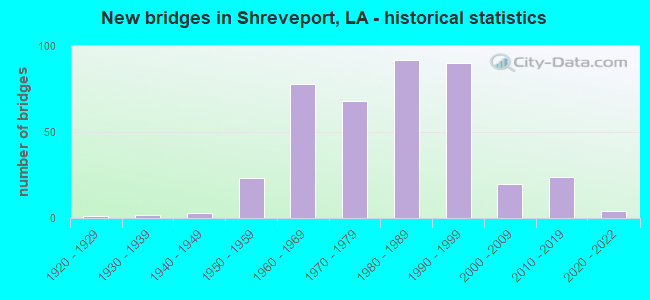
- New bridges - historical statistics
- 11920-1929
- 21930-1939
- 31940-1949
- 231950-1959
- 781960-1969
- 681970-1979
- 921980-1989
- 901990-1999
- 202000-2009
- 242010-2019
- 42020-2022
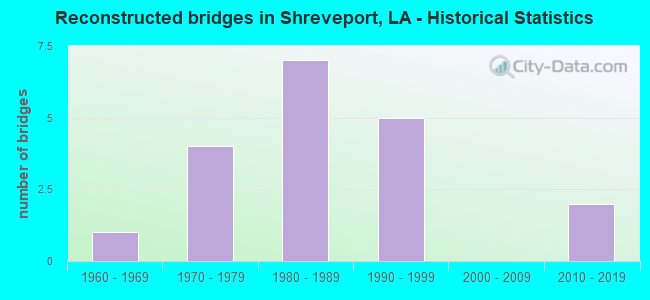
- Reconstructed bridges - Historical Statistics
- 11960-1969
- 41970-1979
- 71980-1989
- 51990-1999
- 02000-2009
- 22010-2019
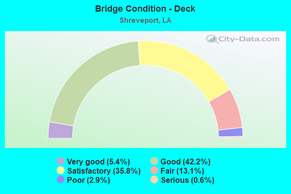
- Bridge Condition - Deck
- 5.4%Very good
- 42.2%Good
- 35.8%Satisfactory
- 13.1%Fair
- 2.9%Poor
- 0.6%Serious
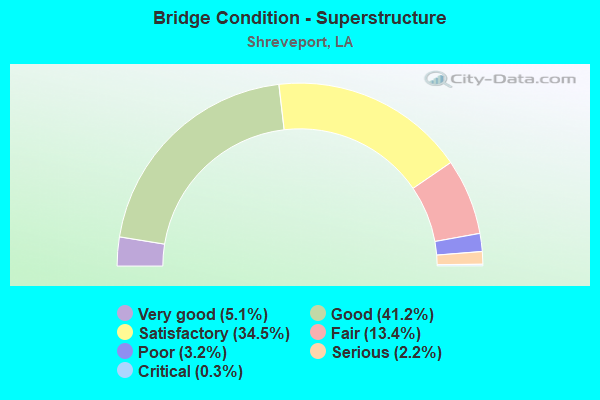
- Bridge Condition - Superstructure
- 5.1%Very good
- 41.2%Good
- 34.5%Satisfactory
- 13.4%Fair
- 3.2%Poor
- 2.2%Serious
- 0.3%Critical
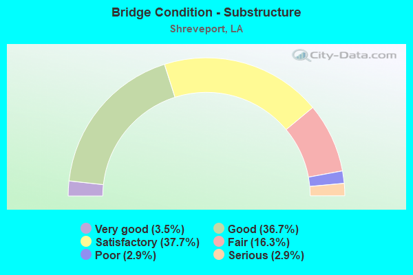
- Bridge Condition - Substructure
- 3.5%Very good
- 36.7%Good
- 37.7%Satisfactory
- 16.3%Fair
- 2.9%Poor
- 2.9%Serious
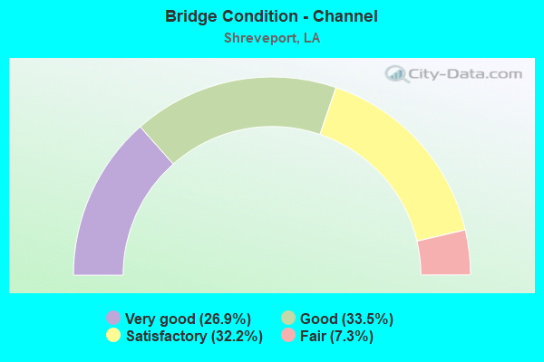
- Bridge Condition - Channel
- 26.9%Very good
- 33.5%Good
- 32.2%Satisfactory
- 7.3%Fair
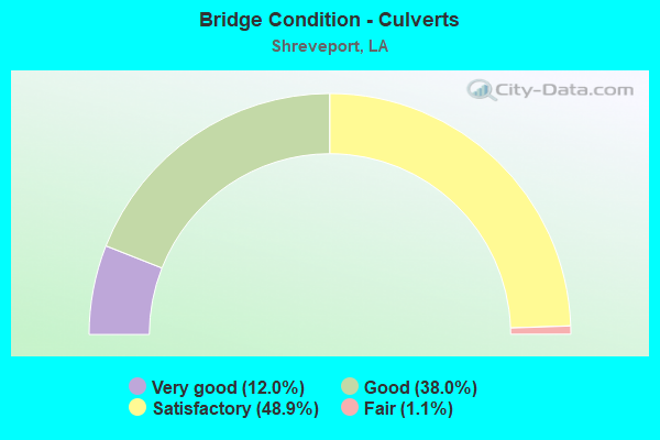
- Bridge Condition - Culverts
- 12.0%Very good
- 38.0%Good
- 48.9%Satisfactory
- 1.1%Fair
Find on map >> Show street view
Structure Number: 40904510118917, Location: I-20/LA 1 INTERCHANGE (Lat: 32.507111, Lng: -93.745361), Route carried "under" structure: Interstate 20, Structure Length: 0. m, Average Daily Traffic: 48,800 (year 2017), Features Intersected: I-20 EB UNDER I-20 EB OF
Minimum Vertical Clearance: 7.41m (24.31ft), Kilometerpoint: 30.471, Lanes on structure: 1, Lanes under structure: 2, Length of Maximum Span: 0.0m
Find on map >> Show street view
Structure Number: 40904510118917, Location: I-20/LA 1 INTERCHANGE (Lat: 32.509800, Lng: -93.743350), Route carried "under" structure: State highway 1, Structure Length: 0. m, Average Daily Traffic: 12,850 (year 2017), Features Intersected: LA 1 SB UNDER I-20 EB OF
Minimum Vertical Clearance: 4.94m (16.21ft), Kilometerpoint: 0.644, Lanes on structure: 1, Lanes under structure: 2, Length of Maximum Span: 0.0m
Find on map >> Show street view
Structure Number: 40904510118917, Location: I-20/LA 1 INTERCHANGE (Lat: 32.509939, Lng: -93.743211), Route carried "under" structure: Ramp Interstate 20, Structure Length: 0. m, Average Daily Traffic: 9,760 (year 2017), Features Intersected: I-20 EB ON-RAMP FROM LA
Minimum Vertical Clearance: 5.21m (17.09ft), Kilometerpoint: 0.100, Lanes on structure: 1, Lanes under structure: 1, Length of Maximum Span: 0.0m
Find on map >> Show street view
Structure Number: 40904510118976, Location: I-20/LA 1 INTERCHANGE (Lat: 32.509931, Lng: -93.743761), Route carried "under" structure: Ramp Interstate 20, Structure Length: 0. m, Average Daily Traffic: 9,760 (year 2017), Features Intersected: I-20 WB ON-RAMP FROM LA
Minimum Vertical Clearance: 11.40m (37.40ft), Kilometerpoint: 0.069, Lanes on structure: 1, Lanes under structure: 1, Length of Maximum Span: 0.0m
Find on map >> Show street view
Structure Number: 40904510118976, Location: I-20/LA 1 INTERCHANGE (Lat: 32.510081, Lng: -93.743611), Route carried "under" structure: State highway 1, Structure Length: 0. m, Average Daily Traffic: 12,850 (year 2017), Features Intersected: LA 1 SB UNDER LA 1 NB OF
Minimum Vertical Clearance: 13.69m (44.91ft), Kilometerpoint: 0.604, Lanes on structure: 1, Lanes under structure: 2, Length of Maximum Span: 0.0m
Find on map >> Show street view
Structure Number: 40904510118976, Location: I-20/LA 1 INTERCHANGE (Lat: 32.510139, Lng: -93.743550), Route carried "under" structure: Ramp Interstate 20, Structure Length: 0. m, Average Daily Traffic: 9,760 (year 2017), Features Intersected: I-20 EB ON-RAMP FROM LA
Minimum Vertical Clearance: 14.54m (47.70ft), Kilometerpoint: 0.063, Lanes on structure: 1, Lanes under structure: 1, Length of Maximum Span: 0.0m
Find on map >> Show street view
Structure Number: 40904510118976, Location: I-20/LA 1 INTERCHANGE (Lat: 32.510431, Lng: -93.742969), Route carried "under" structure: Ramp Interstate 20, Structure Length: 0. m, Average Daily Traffic: 9,760 (year 2017), Features Intersected: I-20 EB OFF-RAMP TO LA 1
Minimum Vertical Clearance: 12.28m (40.29ft), Kilometerpoint: 0.541, Lanes on structure: 1, Lanes under structure: 1, Length of Maximum Span: 0.0m
Find on map >> Show street view
Structure Number: 40904510118976, Location: I-20/LA 1 INTERCHANGE (Lat: 32.510561, Lng: -93.742761), Route carried "under" structure: Ramp Interstate 20, Structure Length: 0. m, Average Daily Traffic: 9,760 (year 2017), Features Intersected: I-20 WB OFF-RAMP TO LA 1
Minimum Vertical Clearance: 10.91m (35.79ft), Kilometerpoint: 0.138, Lanes on structure: 1, Lanes under structure: 1, Length of Maximum Span: 0.0m
Find on map >> Show street view
Structure Number: 40904510118976, Location: I-20/LA 1 INTERCHANGE (Lat: 32.510550, Lng: -93.742211), Route carried "under" structure: Interstate 20, Structure Length: 0. m, Average Daily Traffic: 48,800 (year 2017), Features Intersected: I-20 WB UNDER LA 1 NB OF
Minimum Vertical Clearance: 5.21m (17.09ft), Kilometerpoint: 0.254, Lanes on structure: 1, Lanes under structure: 2, Length of Maximum Span: 0.0m
Find on map >> Show street view
Structure Number: 40904510118976, Location: I-20/LA 1 INTERCHANGE (Lat: 32.510431, Lng: -93.742061), Route carried "under" structure: Interstate 20, Structure Length: 0. m, Average Daily Traffic: 48,800 (year 2017), Features Intersected: I-20 EB UNDER LA 1 NB OF
Minimum Vertical Clearance: 5.46m (17.91ft), Kilometerpoint: 30.956, Lanes on structure: 1, Lanes under structure: 2, Length of Maximum Span: 0.0m
Find on map >> Show street view
Structure Number: 40904510118976, Location: I-20/LA 1 INTERCHANGE (Lat: 32.510239, Lng: -93.741689), Route carried "under" structure: Ramp Interstate 20, Structure Length: 0. m, Average Daily Traffic: 9,760 (year 2017), Features Intersected: I-20 EB ON-RAMP FROM LA
Minimum Vertical Clearance: 10.12m (33.20ft), Kilometerpoint: 0.259, Lanes on structure: 1, Lanes under structure: 1, Length of Maximum Span: 0.0m
Find on map >> Show street view
Structure Number: 40904510118976, Location: I-20/LA 1 INTERCHANGE (Lat: 32.509511, Lng: -93.741081), Route carried "under" structure: Ramp Interstate 20, Structure Length: 0. m, Average Daily Traffic: 9,760 (year 2017), Features Intersected: I-20 EB ON-RAMP FROM LA
Minimum Vertical Clearance: 9.57m (31.40ft), Kilometerpoint: 0.069, Lanes on structure: 1, Lanes under structure: 1, Length of Maximum Span: 0.0m
Find on map >> Show street view
Structure Number: 40904510118981, Location: I-20/LA 1 INTERCHANGE (Lat: 32.509889, Lng: -93.742889), Route carried "under" structure: Ramp Interstate 20, Structure Length: 0. m, Average Daily Traffic: 9,760 (year 2017), Features Intersected: I-20 WB OFF-RAMP TO LA 1
Minimum Vertical Clearance: 5.12m (16.80ft), Kilometerpoint: 0.214, Lanes on structure: 2, Lanes under structure: 1, Length of Maximum Span: 0.0m
Find on map >> Show street view
Structure Number: 40904510118981, Location: I-20/LA 1 INTERCHANGE (Lat: 32.510319, Lng: -93.742150), Route carried "under" structure: State highway 1, Structure Length: 0. m, Average Daily Traffic: 12,850 (year 2017), Features Intersected: LA 1 NB UNDER I-20 EB
Minimum Vertical Clearance: 13.20m (43.31ft), Kilometerpoint: 13.924, Lanes on structure: 2, Lanes under structure: 2, Length of Maximum Span: 0.0m
Find on map >> Show street view
Structure Number: 40904510118981, Location: I-20/LA 1 INTERCHANGE (Lat: 32.509650, Lng: -93.743189), Route carried "under" structure: State highway 1, Structure Length: 0. m, Average Daily Traffic: 12,850 (year 2017), Features Intersected: LA 1 SB UNDER I-20 EB
Minimum Vertical Clearance: 10.73m (35.20ft), Kilometerpoint: 0.666, Lanes on structure: 2, Lanes under structure: 2, Length of Maximum Span: 0.0m
Find on map >> Show street view
Structure Number: 40904510118982, Location: I-20/LA 1 INTERCHANGE (Lat: 32.509669, Lng: -93.743800), Route carried "under" structure: Ramp Interstate 20, Structure Length: 0. m, Average Daily Traffic: 9,760 (year 2017), Features Intersected: I-20 WB ON-RAMP FROM LA
Minimum Vertical Clearance: 8.57m (28.12ft), Kilometerpoint: 0.098, Lanes on structure: 2, Lanes under structure: 1, Length of Maximum Span: 0.0m
Find on map >> Show street view
Structure Number: 40904510118982, Location: I-20/LA 1 INTERCHANGE (Lat: 32.510011, Lng: -93.743311), Route carried "under" structure: Ramp Interstate 20, Structure Length: 0. m, Average Daily Traffic: 9,760 (year 2017), Features Intersected: I-20 EB ON-RAMP FROM LA
Minimum Vertical Clearance: 12.50m (41.01ft), Kilometerpoint: 0.089, Lanes on structure: 2, Lanes under structure: 1, Length of Maximum Span: 0.0m
Find on map >> Show street view
Structure Number: 40904510118982, Location: I-20/LA 1 INTERCHANGE (Lat: 32.510519, Lng: -93.742339), Route carried "under" structure: State highway 1, Structure Length: 0. m, Average Daily Traffic: 12,850 (year 2017), Features Intersected: LA 1 NB UNDER I-20 WB
Minimum Vertical Clearance: 12.71m (41.70ft), Kilometerpoint: 13.951, Lanes on structure: 2, Lanes under structure: 2, Length of Maximum Span: 0.0m
Find on map >> Show street view
Structure Number: 40904510118982, Location: I-20/LA 1 INTERCHANGE (Lat: 32.510239, Lng: -93.742889), Route carried "under" structure: Ramp Interstate 20, Structure Length: 0. m, Average Daily Traffic: 9,760 (year 2017), Features Intersected: I-20 WB OFF-RAMP TO LA 1
Minimum Vertical Clearance: 5.30m (17.39ft), Kilometerpoint: 0.175, Lanes on structure: 2, Lanes under structure: 1, Length of Maximum Span: 0.0m
Find on map >> Show street view
Structure Number: 40904510118982, Location: I-20/LA 1 INTERCHANGE (Lat: 32.510019, Lng: -93.743089), Route carried "under" structure: Ramp Interstate 20, Structure Length: 0. m, Average Daily Traffic: 9,760 (year 2017), Features Intersected: I-20 EB OFF-RAMP TO LA 1
Minimum Vertical Clearance: 6.37m (20.90ft), Kilometerpoint: 0.494, Lanes on structure: 2, Lanes under structure: 1, Length of Maximum Span: 0.0m
Find on map >> Show street view
Structure Number: 40904510118982, Location: I-20/LA 1 INTERCHANGE (Lat: 32.509911, Lng: -93.743450), Route carried "under" structure: State highway 1, Structure Length: 0. m, Average Daily Traffic: 12,850 (year 2017), Features Intersected: LA 1 SB UNDER I-20 WB
Minimum Vertical Clearance: 11.77m (38.62ft), Kilometerpoint: 0.628, Lanes on structure: 2, Lanes under structure: 2, Length of Maximum Span: 0.0m
Find on map >> Show street view
Structure Number: 40904510119158, Location: I-20/LA 1 INTERCHANGE (Lat: 32.510739, Lng: -93.742569), Route carried "under" structure: State highway 1, Structure Length: 0. m, Average Daily Traffic: 12,850 (year 2017), Features Intersected: LA 1 NB UNDER I-20 WB OF
Minimum Vertical Clearance: 5.03m (16.50ft), Kilometerpoint: 13.984, Lanes on structure: 1, Lanes under structure: 2, Length of Maximum Span: 0.0m
Find on map >> Show street view
Structure Number: 40904510119158, Location: I-20/LA 1 INTERCHANGE (Lat: 32.509889, Lng: -93.742950), Route carried "under" structure: Ramp Interstate 20, Structure Length: 0. m, Average Daily Traffic: 9,760 (year 2017), Features Intersected: I-20 EB ON-RAMP FROM LA
Minimum Vertical Clearance: 5.30m (17.39ft), Kilometerpoint: 0.126, Lanes on structure: 1, Lanes under structure: 1, Length of Maximum Span: 0.0m
Find on map >> Show street view
Structure Number: 40904510119175, Location: I-20/LA 1 INTERCHANGE (Lat: 32.510039, Lng: -93.741850), Route carried "under" structure: State highway 1, Structure Length: 0. m, Average Daily Traffic: 12,850 (year 2017), Features Intersected: LA 1 NB UNDER LA 1 SB ON
Minimum Vertical Clearance: 7.07m (23.20ft), Kilometerpoint: 13.882, Lanes on structure: 1, Lanes under structure: 2, Length of Maximum Span: 0.0m
Find on map >> Show street view
Structure Number: 40904510182271, Location: 0.55 MI E OF I-49 (Lat: 32.500061, Lng: -93.752261), Route carried "under" structure: Interstate 20, Structure Length: 0. m, Average Daily Traffic: 57,500 (year 2017), Features Intersected: I-20 WB UNDER STONER AVE
Minimum Vertical Clearance: 7.10m (23.29ft), Kilometerpoint: 1.785, Lanes on structure: 4, Lanes under structure: 4, Length of Maximum Span: 0.0m
Find on map >> Show street view
Structure Number: 40904513000001, Location: INT. I-20 & 3132 (Lat: 32.456319, Lng: -93.844369), Route carried "under" structure: Interstate 20, Structure Length: 0. m, Average Daily Traffic: 62,300 (year 2015), Features Intersected: 3132 OVER I-20 WB
Minimum Vertical Clearance: 5.15m (16.90ft), Kilometerpoint: 12.043, Lanes on structure: 2, Length of Maximum Span: 0.0m
Find on map >> Show street view
Structure Number: 40904513000001, Location: INT. I-20 &3132 (Lat: 32.456489, Lng: -93.844439), Route carried "under" structure: Interstate 20, Structure Length: 0. m, Average Daily Traffic: 62,300 (year 2015), Features Intersected: 3132 OVER I-20 WB OFF RA
Minimum Vertical Clearance: 4.91m (16.11ft), Kilometerpoint: 0.146, Lanes on structure: 2, Length of Maximum Span: 0.0m
Find on map >> Show street view
Structure Number: 40904513000001, Location: INT. I-20 & 3132 (Lat: 32.456039, Lng: -93.844650), Route carried "under" structure: Interstate 20, Structure Length: 0. m, Average Daily Traffic: 62,300 (year 2015), Features Intersected: 3132 OVER I-20 EB
Minimum Vertical Clearance: 5.12m (16.80ft), Kilometerpoint: 19.146, Lanes on structure: 2, Length of Maximum Span: 0.0m
Find on map >> Show street view
Structure Number: 40904513000232, Location: .18 MILES NORTH OF I20 (Lat: 32.459519, Lng: -93.846150), Route carried "under" structure: Interstate 220, Structure Length: 0. m, Average Daily Traffic: 37,380 (year 2015), Features Intersected: 220 WEST OVER 220 E ON R
Minimum Vertical Clearance: 5.58m (18.31ft), Kilometerpoint: 0.851, Lanes on structure: 1, Length of Maximum Span: 0.0m
Find on map >> Show street view
Structure Number: 40904513002341, Location: 2.3 MILES NORTH OF I20 (Lat: 32.485469, Lng: -93.828100), Route carried "under" structure: Interstate 220, Structure Length: 0. m, Average Daily Traffic: 18,660 (year 2015), Features Intersected: LAKESHORE DR OVER 220 EA
Minimum Vertical Clearance: 5.09m (16.70ft), Kilometerpoint: 3.732, Lanes on structure: 2, Length of Maximum Span: 0.0m
Find on map >> Show street view
Structure Number: 40904513002341, Location: 2.3 MILES NORTH OF I20 (Lat: 32.485750, Lng: -93.828231), Route carried "under" structure: Interstate 220, Structure Length: 0. m, Average Daily Traffic: 18,660 (year 2015), Features Intersected: LAKESHORE DR OVER 220 WE
Minimum Vertical Clearance: 5.46m (17.91ft), Kilometerpoint: 9.566, Lanes on structure: 2, Length of Maximum Span: 0.0m
Find on map >> Show street view
Structure Number: 40904513002351, Location: 2.3 MILES NORTH OF I20 (Lat: 32.485761, Lng: -93.827889), Route carried "under" structure: Interstate 220, Structure Length: 0. m, Average Daily Traffic: 31,100 (year 2015), Features Intersected: LAKESHORE DR OVER 220 EA
Minimum Vertical Clearance: 5.33m (17.49ft), Kilometerpoint: 3.769, Lanes on structure: 2, Length of Maximum Span: 0.0m
Find on map >> Show street view
Structure Number: 40904513002351, Location: 2.3 MILES NORTH OF I20 (Lat: 32.485769, Lng: -93.828219), Route carried "under" structure: Interstate 220, Structure Length: 0. m, Average Daily Traffic: 31,100 (year 2015), Features Intersected: LAKESHORE DR OVER 220 WE
Minimum Vertical Clearance: 5.52m (18.11ft), Kilometerpoint: 9.564, Lanes on structure: 2, Length of Maximum Span: 0.0m
Find on map >> Show street view
Structure Number: 40904513003081, Location: 3 MILES WEST OF US 71 (Lat: 32.520019, Lng: -93.808719), Route carried "under" structure: Interstate 220, Structure Length: 0. m, Average Daily Traffic: 62,200 (year 2015), Features Intersected: 220 OVER 173 NORTH
Minimum Vertical Clearance: 7.50m (24.61ft), Kilometerpoint: 6.024, Lanes on structure: 2, Length of Maximum Span: 0.0m
Find on map >> Show street view
Structure Number: 40904513003081, Location: 3 MILES WEST OF US 71 (Lat: 32.520039, Lng: -93.809150), Route carried "under" structure: Interstate 220, Structure Length: 0. m, Average Daily Traffic: 62,200 (year 2015), Features Intersected: 220 OVER 173 SOUTH
Minimum Vertical Clearance: 7.96m (26.12ft), Kilometerpoint: 16.145, Lanes on structure: 2, Length of Maximum Span: 0.0m
Find on map >> Show street view
Structure Number: 40904513007791, Location: 0.4 MI S OF LA 3194 (Lat: 32.554031, Lng: -93.781519), Route carried "under" structure: Ramp Interstate 220, Structure Length: 0. m, Average Daily Traffic: 4,770 (year 2018), Features Intersected: I-220 WB OFF-RAMP TO US
Minimum Vertical Clearance: 5.29m (17.36ft), Kilometerpoint: 0.454, Lanes on structure: 2, Lanes under structure: 1, Length of Maximum Span: 0.0m
Find on map >> Show street view
Structure Number: 40904513007791, Location: 0.4 MI S OF LA 3194 (Lat: 32.554081, Lng: -93.781469), Route carried "under" structure: US 71, Structure Length: 0. m, Average Daily Traffic: 14,300 (year 2018), Features Intersected: US 71 SB UNDER I-220 EB
Minimum Vertical Clearance: 5.22m (17.13ft), Kilometerpoint: 2.775, Lanes on structure: 2, Lanes under structure: 3, Length of Maximum Span: 0.0m
Find on map >> Show street view
Structure Number: 40904513007791, Location: 0.4 MI S OF LA 3194 (Lat: 32.554011, Lng: -93.781311), Route carried "under" structure: US 71, Structure Length: 0. m, Average Daily Traffic: 14,300 (year 2018), Features Intersected: US 71 NB UNDER I-220 EB
Minimum Vertical Clearance: 5.21m (17.09ft), Kilometerpoint: 5.489, Lanes on structure: 2, Lanes under structure: 2, Length of Maximum Span: 0.0m
Find on map >> Show street view
Structure Number: 40904513007791, Location: 0.4 MI S OF LA 3194 (Lat: 32.554050, Lng: -93.781269), Route carried "under" structure: Ramp Interstate 220, Structure Length: 0. m, Average Daily Traffic: 4,770 (year 2018), Features Intersected: I-220 EB OFF-RAMP TO US
Minimum Vertical Clearance: 5.32m (17.45ft), Kilometerpoint: 0.414, Lanes on structure: 2, Lanes under structure: 1, Length of Maximum Span: 0.0m
Find on map >> Show street view
Structure Number: 40904513007792, Location: 0.4 MI S OF LA 3194 (Lat: 32.554331, Lng: -93.781419), Route carried "under" structure: Ramp Interstate 220, Structure Length: 0. m, Average Daily Traffic: 4,770 (year 2018), Features Intersected: I-220 EB OFF-RAMP TO US
Minimum Vertical Clearance: 6.23m (20.44ft), Kilometerpoint: 0.447, Lanes on structure: 2, Lanes under structure: 1, Length of Maximum Span: 0.0m
Find on map >> Show street view
Structure Number: 40904513007792, Location: 0.4 MI S OF LA 3194 (Lat: 32.554289, Lng: -93.781461), Route carried "under" structure: US 71, Structure Length: 0. m, Average Daily Traffic: 14,300 (year 2018), Features Intersected: US 71 NB UNDER I-220 WB
Minimum Vertical Clearance: 6.16m (20.21ft), Kilometerpoint: 5.523, Lanes on structure: 2, Lanes under structure: 2, Length of Maximum Span: 0.0m
Find on map >> Show street view
Structure Number: 40904513007792, Location: 0.4 MI S OF LA 3194 (Lat: 32.554361, Lng: -93.781619), Route carried "under" structure: US 71, Structure Length: 0. m, Average Daily Traffic: 14,300 (year 2018), Features Intersected: US 71 SB UNDER I-220 WB
Minimum Vertical Clearance: 6.18m (20.28ft), Kilometerpoint: 2.741, Lanes on structure: 2, Lanes under structure: 3, Length of Maximum Span: 0.0m
Find on map >> Show street view
Structure Number: 40904513007792, Location: 0.4 MI S OF LA 3194 (Lat: 32.554311, Lng: -93.781669), Route carried "under" structure: Ramp Interstate 220, Structure Length: 0. m, Average Daily Traffic: 4,770 (year 2018), Features Intersected: I-220 WB OFF-RAMP TO US
Minimum Vertical Clearance: 6.27m (20.57ft), Kilometerpoint: 0.420, Lanes on structure: 2, Lanes under structure: 1, Length of Maximum Span: 0.0m
Find on map >> Show street view
Structure Number: 40904520117627, Location: I-20/I-49 INTERCHANGE (Lat: 32.496531, Lng: -93.759900), Route carried "under" structure: Interstate 49, Structure Length: 0. m, Average Daily Traffic: 35,300 (year 2017), Features Intersected: I-49 SB UNDER I-20 EB OF
Minimum Vertical Clearance: 5.94m (19.49ft), Kilometerpoint: 0.391, Lanes on structure: 1, Lanes under structure: 2, Length of Maximum Span: 0.0m
Find on map >> Show street view
Structure Number: 40904550801181, Location: 2.8 MI S OF LA 526 (Lat: 32.356169, Lng: -93.751611), Route carried "under" structure: Interstate 49, Structure Length: 0. m, Average Daily Traffic: 42,000 (year 2015), Features Intersected: I-49 N UNDER SOUTHERN LO
Minimum Vertical Clearance: 5.24m (17.19ft), Kilometerpoint: 1.886, Lanes on structure: 2, Length of Maximum Span: 0.0m
Find on map >> Show street view
Structure Number: 40904550801181, Location: 2.8 MI S OF LA 526 (Lat: 32.356369, Lng: -93.751969), Route carried "under" structure: Interstate 49, Structure Length: 0. m, Average Daily Traffic: 42,000 (year 2015), Features Intersected: i-49 S UNDER SOUTHERN L
Minimum Vertical Clearance: 5.30m (17.39ft), Kilometerpoint: 16.238, Lanes on structure: 2, Length of Maximum Span: 0.0m
Find on map >> Show street view
Structure Number: 40904550802581, Location: 1.4 MILES SOUTH OF LA 526 (Lat: 32.376500, Lng: -93.751661), Route carried "under" structure: Interstate 49, Structure Length: 0. m, Average Daily Traffic: 4,200 (year 2015), Features Intersected: I49 NORTH UNDER MAYO RD
Minimum Vertical Clearance: 5.09m (16.70ft), Kilometerpoint: 4.141, Lanes on structure: 2, Length of Maximum Span: 0.0m
Find on map >> Show street view
Structure Number: 40904550802581, Location: 1.4 MILES SOUTH OF LA 526 (Lat: 32.376650, Lng: -93.752031), Route carried "under" structure: Interstate 49, Structure Length: 0. m, Average Daily Traffic: 4,200 (year 2015), Features Intersected: I49 SOUTH UNDER MAYO RD
Minimum Vertical Clearance: 5.15m (16.90ft), Kilometerpoint: 13.990, Lanes on structure: 2, Length of Maximum Span: 0.0m
Find on map >> Show street view
Structure Number: 40904550803571, Location: .5 MILES SOUTH OF LA 526 (Lat: 32.390881, Lng: -93.751681), Route carried "under" structure: Interstate 49, Structure Length: 0. m, Average Daily Traffic: 4,200 (year 2015), Features Intersected: I49 NORTH UNDER FLOURNOY
Minimum Vertical Clearance: 5.36m (17.59ft), Kilometerpoint: 5.736, Lanes on structure: 2, Length of Maximum Span: 0.0m
Find on map >> Show street view
Structure Number: 40904550803571, Location: .5 MILES SOUTH OF LA 526 (Lat: 32.391011, Lng: -93.752061), Route carried "under" structure: Interstate 49, Structure Length: 0. m, Average Daily Traffic: 4,200 (year 2015), Features Intersected: I49 SOUTH UNDER FLOURNOY
Minimum Vertical Clearance: 5.64m (18.50ft), Kilometerpoint: 12.398, Lanes on structure: 2, Length of Maximum Span: 0.0m
Find on map >> Show street view
Structure Number: 40904550804051, Location: 1.4 MILES SOUTH OF LA 313 (Lat: 32.398311, Lng: -93.751769), Route carried "under" structure: Interstate 49, Structure Length: 0. m, Average Daily Traffic: 25,200 (year 2015), Features Intersected: I49 NORTH OVER LA 526 EA
Minimum Vertical Clearance: 5.36m (17.59ft), Kilometerpoint: 17.997, Lanes on structure: 4, Length of Maximum Span: 0.0m
Find on map >> Show street view
Structure Number: 40904550804051, Location: 1.4 MILES SOUTH OF LA 313 (Lat: 32.398461, Lng: -93.751581), Route carried "under" structure: Interstate 49, Structure Length: 0. m, Average Daily Traffic: 25,200 (year 2015), Features Intersected: I49 NORTH OVER LA 526 WE
Minimum Vertical Clearance: 5.43m (17.81ft), Kilometerpoint: 7.686, Lanes on structure: 2, Length of Maximum Span: 0.0m
Find on map >> Show street view
Structure Number: 40904550804052, Location: 1.4 MILES SOUTH OF LA 313 (Lat: 32.398281, Lng: -93.752161), Route carried "under" structure: Interstate 49, Structure Length: 0. m, Average Daily Traffic: 25,200 (year 2015), Features Intersected: I49 SOUTH OVER LA 526 EA
Minimum Vertical Clearance: 5.24m (17.19ft), Kilometerpoint: 17.960, Lanes on structure: 2, Length of Maximum Span: 0.0m
Find on map >> Show street view
Structure Number: 40904550804052, Location: 1.4 MILES SOUTH OF LA 313 (Lat: 32.398439, Lng: -93.751919), Route carried "under" structure: Interstate 49, Structure Length: 0. m, Average Daily Traffic: 25,200 (year 2015), Features Intersected: I49 SOUTH OVER LA 526 WE
Minimum Vertical Clearance: 5.27m (17.29ft), Kilometerpoint: 7.718, Lanes on structure: 2, Length of Maximum Span: 0.0m
Find on map >> Show street view
Structure Number: 40904550804911, Location: 1.2 MI E OF I-20 (Lat: 32.481939, Lng: -93.754989), Route carried "under" structure: Ramp Interstate 49, Structure Length: 0. m, Average Daily Traffic: 7,410 (year 2017), Features Intersected: I-49 NB ON RAMP FROM KIN
Minimum Vertical Clearance: 5.85m (19.19ft), Kilometerpoint: 0.003, Lanes on structure: 3, Lanes under structure: 2, Length of Maximum Span: 0.0m
Find on map >> Show street view
Structure Number: 40904550805287, Location: I-49/LA 3132 INTERCHANGE (Lat: 32.418989, Lng: -93.749731), Route carried "under" structure: Ramp Interstate 49, Structure Length: 0. m, Average Daily Traffic: 4,180 (year 2017), Features Intersected: I-49 SB ON-RAMP FROM LA
Minimum Vertical Clearance: 5.76m (18.90ft), Kilometerpoint: 0.430, Lanes on structure: 1, Lanes under structure: 1, Length of Maximum Span: 0.0m
Find on map >> Show street view
Structure Number: 40904550805287, Location: I-49/LA 3132 INTERCHANGE (Lat: 32.419050, Lng: -93.749900), Route carried "under" structure: Ramp Interstate 49, Structure Length: 0. m, Average Daily Traffic: 4,180 (year 2017), Features Intersected: I-49 NB ON-RAMP FROM LA
Minimum Vertical Clearance: 5.76m (18.90ft), Kilometerpoint: 0.398, Lanes on structure: 1, Lanes under structure: 1, Length of Maximum Span: 0.0m
Find on map >> Show street view
Structure Number: 40904550805326, Location: 5.4 miles south of I20 (Lat: 32.419181, Lng: -93.749561), Route carried "under" structure: Interstate 49, Structure Length: 0. m, Average Daily Traffic: 4,180 (year 2015), Features Intersected: 3132 WB over I49 to I49
Minimum Vertical Clearance: 5.52m (18.11ft), Kilometerpoint: 4.237, Lanes on structure: 2, Length of Maximum Span: 0.0m
Find on map >> Show street view
Structure Number: 40904550805326, Location: 5.40 miles south of I20 (Lat: 32.418969, Lng: -93.749969), Route carried "under" structure: Interstate 49, Structure Length: 0. m, Average Daily Traffic: 4,180 (year 2015), Features Intersected: 3132 WB over I49 to I49
Minimum Vertical Clearance: 6.58m (21.59ft), Kilometerpoint: 9.270, Lanes on structure: 2, Length of Maximum Span: 0.0m
Find on map >> Show street view
Structure Number: 40904550805401, Location: 1.4 MILES NORTH OF LA 526 (Lat: 32.418931, Lng: -93.749461), Route carried "under" structure: Interstate 49, Structure Length: 0. m, Average Daily Traffic: 25,080 (year 2015), Features Intersected: I49 NORTH OVER 3132
Minimum Vertical Clearance: 5.30m (17.39ft), Kilometerpoint: 12.283, Lanes on structure: 2, Length of Maximum Span: 0.0m
Find on map >> Show street view
Structure Number: 40904550805401, Location: 1.4 MILES NORTH OF LA 526 (Lat: 32.419131, Lng: -93.749300), Route carried "under" structure: Interstate 49, Structure Length: 0. m, Average Daily Traffic: 25,080 (year 2015), Features Intersected: i49 NORTH OVER 3132
Minimum Vertical Clearance: 5.00m (16.40ft), Kilometerpoint: 4.242, Lanes on structure: 2, Length of Maximum Span: 0.0m
Find on map >> Show street view
Structure Number: 40904550805402, Location: 1.4 miles north of LA 526 (Lat: 32.419039, Lng: -93.750211), Route carried "under" structure: Interstate 49, Structure Length: 0. m, Average Daily Traffic: 35,700 (year 2015), Features Intersected: i49 south over 3132 east
Minimum Vertical Clearance: 5.06m (16.60ft), Kilometerpoint: 12.212, Lanes on structure: 2, Length of Maximum Span: 0.0m
Find on map >> Show street view
Structure Number: 40904550805402, Location: 1.4 miles north of LA 526 (Lat: 32.419261, Lng: -93.750119), Route carried "under" structure: Interstate 49, Structure Length: 0. m, Average Daily Traffic: 35,700 (year 2015), Features Intersected: I49 south over 3132 west
Minimum Vertical Clearance: 5.43m (17.81ft), Kilometerpoint: 4.321, Lanes on structure: 2, Length of Maximum Span: 0.0m
Find on map >> Show street view
Structure Number: 40904550805705, Location: 5.4 miles south of I49 (Lat: 32.419019, Lng: -93.749931), Route carried "under" structure: Interstate 49, Structure Length: 0. m, Average Daily Traffic: 4,180 (year 2015), Features Intersected: 3132 EB over I49 to I49
Minimum Vertical Clearance: 5.55m (18.21ft), Kilometerpoint: 0.393, Lanes on structure: 2, Length of Maximum Span: 0.0m
Find on map >> Show street view
Structure Number: 40904550805705, Location: 5.4 miles south of I49 (Lat: 32.419231, Lng: -93.749550), Route carried "under" structure: Interstate 49, Structure Length: 0. m, Average Daily Traffic: 4,180 (year 2015), Features Intersected: 3132 EB over I49 to I49
Minimum Vertical Clearance: 6.49m (21.29ft), Kilometerpoint: 0.436, Lanes on structure: 2, Length of Maximum Span: 0.0m
Find on map >> Show street view
Structure Number: 40904550805758, Location: 5.4 miles south of I20 (Lat: 32.419169, Lng: -93.749600), Route carried "under" structure: Ramp Interstate 49, Structure Length: 0. m, Average Daily Traffic: 4,180 (year 2017), Features Intersected: I-49 SB On-Ramp From LA
Minimum Vertical Clearance: 5.52m (18.11ft), Kilometerpoint: 0.409, Lanes on structure: 1, Lanes under structure: 1, Length of Maximum Span: 0.0m
Find on map >> Show street view
Structure Number: 40904550805758, Location: 5.4 miles south of I20 (Lat: 32.419150, Lng: -93.749911), Route carried "under" structure: Ramp Interstate 49, Structure Length: 0. m, Average Daily Traffic: 4,180 (year 2017), Features Intersected: I-49 NB On-Ramp From LA
Minimum Vertical Clearance: 5.49m (18.01ft), Kilometerpoint: 0.402, Lanes on structure: 1, Lanes under structure: 1, Length of Maximum Span: 0.0m
Find on map >> Show street view
Structure Number: 40904550807191, Location: 1.6 miles north of LA 313 (Lat: 32.442000, Lng: -93.756200), Route carried "under" structure: Interstate 49, Structure Length: 0. m, Average Daily Traffic: 35,700 (year 2015), Features Intersected: I49 NB over 511 west
Minimum Vertical Clearance: 5.21m (17.09ft), Kilometerpoint: 7.253, Lanes on structure: 3, Length of Maximum Span: 0.0m
Find on map >> Show street view
Structure Number: 40904550807191, Location: 1.6 miles north of LA 313 (Lat: 32.441819, Lng: -93.756419), Route carried "under" structure: Interstate 49, Structure Length: 0. m, Average Daily Traffic: 35,700 (year 2015), Features Intersected: I49 NB over 511 east
Minimum Vertical Clearance: 5.24m (17.19ft), Kilometerpoint: 2.313, Lanes on structure: 3, Length of Maximum Span: 0.0m
Find on map >> Show street view
Structure Number: 40904550807192, Location: 1.6 miles north of LA 313 (Lat: 32.441850, Lng: -93.756689), Route carried "under" structure: Interstate 49, Structure Length: 0. m, Average Daily Traffic: 35,700 (year 2015), Features Intersected: I49 SB over 511 east
Minimum Vertical Clearance: 6.74m (22.11ft), Kilometerpoint: 2.287, Lanes on structure: 2, Length of Maximum Span: 0.0m
Find on map >> Show street view
Structure Number: 40904550807192, Location: 1.6 miles north of LA 313 (Lat: 32.441989, Lng: -93.756469), Route carried "under" structure: Interstate 49, Structure Length: 0. m, Average Daily Traffic: 35,700 (year 2015), Features Intersected: I49 SB over 511 west
Minimum Vertical Clearance: 6.71m (22.01ft), Kilometerpoint: 7.279, Lanes on structure: 2, Length of Maximum Span: 0.0m
Find on map >> Show street view
Structure Number: 40904550809911, Location: 1.2 MI E OF I-20 (Lat: 32.481519, Lng: -93.754789), Route carried "under" structure: Ramp Interstate 49, Structure Length: 0. m, Average Daily Traffic: 7,410 (year 2017), Features Intersected: I-49 NB OFF RAMP TO KING
Minimum Vertical Clearance: 6.10m (20.01ft), Kilometerpoint: 0.591, Lanes on structure: 3, Lanes under structure: 1, Length of Maximum Span: 0.0m
Find on map >> Show street view
Structure Number: 40904550809912, Location: 1.2 MI E OF I-20 (Lat: 32.481669, Lng: -93.755061), Route carried "under" structure: Ramp Interstate 49, Structure Length: 0. m, Average Daily Traffic: 7,410 (year 2017), Features Intersected: KINGS HWY WB ON RAMP TO
Minimum Vertical Clearance: 5.97m (19.59ft), Kilometerpoint: 0.006, Lanes on structure: 3, Lanes under structure: 1, Length of Maximum Span: 0.0m
Find on map >> Show street view
Structure Number: 40904550809912, Location: 1.2 MI W OF I-20 (Lat: 32.481889, Lng: -93.755069), Route carried "under" structure: Ramp Interstate 49, Structure Length: 0. m, Average Daily Traffic: 7,410 (year 2017), Features Intersected: I-49 NB ON-RAMP FROM KIN
Minimum Vertical Clearance: 5.64m (18.50ft), Kilometerpoint: 0.000, Lanes on structure: 3, Lanes under structure: 1, Length of Maximum Span: 0.0m
Find on map >> Show street view
Structure Number: 40904550809912, Location: 1.2 MI W OF I-20 (Lat: 32.482111, Lng: -93.755261), Route carried "under" structure: Ramp Interstate 49, Structure Length: 0. m, Average Daily Traffic: 7,410 (year 2017), Features Intersected: I-49 SB OFF RAMP TO KING
Minimum Vertical Clearance: 5.64m (18.50ft), Kilometerpoint: 0.507, Lanes on structure: 3, Lanes under structure: 1, Length of Maximum Span: 0.0m
Find on map >> Show street view
Structure Number: 40904550810451, Location: 0.1 MI S OF I-20 (Lat: 32.495650, Lng: -93.758981), Route carried "under" structure: Interstate 49, Structure Length: 0. m, Average Daily Traffic: 41,400 (year 2015), Features Intersected: I-49 N OVER 79 AT I-20
Minimum Vertical Clearance: 5.36m (17.59ft), Kilometerpoint: 2.834, Lanes on structure: 2, Length of Maximum Span: 0.0m
Find on map >> Show street view
Structure Number: 40904550810451, Location: INT. I-49 & I-20 (Lat: 32.496469, Lng: -93.759619), Route carried "under" structure: Interstate 49, Structure Length: 0. m, Average Daily Traffic: 41,400 (year 2015), Features Intersected: I-20 E ON RAMP UNDER I-4
Minimum Vertical Clearance: 7.53m (24.70ft), Kilometerpoint: 0.216, Lanes on structure: 2, Length of Maximum Span: 0.0m
Find on map >> Show street view
Structure Number: 40904550810451, Location: INT. I-49 & I-20 (Lat: 32.496661, Lng: -93.795650), Route carried "under" structure: Interstate 49, Structure Length: 0. m, Average Daily Traffic: 41,400 (year 2015), Features Intersected: I-20 E UNDER I-49 N
Minimum Vertical Clearance: 6.55m (21.49ft), Kilometerpoint: 17.769, Lanes on structure: 2, Length of Maximum Span: 0.0m
Find on map >> Show street view
Structure Number: 40904550810451, Location: INT. I-49 & I-20 (Lat: 32.496781, Lng: -93.759719), Route carried "under" structure: Interstate 49, Structure Length: 0. m, Average Daily Traffic: 41,400 (year 2015), Features Intersected: I-20 W UNDER I-49 N
Minimum Vertical Clearance: 6.22m (20.41ft), Kilometerpoint: 2.575, Lanes on structure: 2, Length of Maximum Span: 0.0m
Find on map >> Show street view
Structure Number: 40904550810451, Location: INT. I-49 & I-20 (Lat: 32.497119, Lng: -93.759611), Route carried "under" structure: Interstate 49, Structure Length: 0. m, Average Daily Traffic: 41,400 (year 2015), Features Intersected: I-20 W OFF/R TO LINWOOD
Minimum Vertical Clearance: 6.34m (20.80ft), Kilometerpoint: 0.259, Lanes on structure: 2, Length of Maximum Span: 0.0m
Find on map >> Show street view
Structure Number: 40904550810452, Location: 0.1 MI S OF I-20 (Lat: 32.495500, Lng: -93.759281), Route carried "under" structure: Interstate 49, Structure Length: 0. m, Average Daily Traffic: 41,400 (year 2015), Features Intersected: I-49 S OVER 79 AT I-20
Minimum Vertical Clearance: 5.49m (18.01ft), Kilometerpoint: 14.935, Lanes on structure: 2, Length of Maximum Span: 0.0m
Find on map >> Show street view
Structure Number: 40904550810452, Location: INT. I-49 & I-20 (Lat: 32.496261, Lng: -93.759881), Route carried "under" structure: Interstate 49, Structure Length: 0. m, Average Daily Traffic: 41,400 (year 2015), Features Intersected: I-20 E ON RAMP UNDER I-4
Minimum Vertical Clearance: 7.16m (23.49ft), Kilometerpoint: 0.182, Lanes on structure: 2, Length of Maximum Span: 0.0m
Find on map >> Show street view
Structure Number: 40904550810452, Location: INT. I-49 & I-20 (Lat: 32.696489, Lng: -93.759981), Route carried "under" structure: Interstate 49, Structure Length: 0. m, Average Daily Traffic: 41,400 (year 2015), Features Intersected: I-20 E UNDER I-49 S
Minimum Vertical Clearance: 6.49m (21.29ft), Kilometerpoint: 28.603, Lanes on structure: 2, Length of Maximum Span: 0.0m
Find on map >> Show street view
Structure Number: 40904550810452, Location: INT. I-49 & I-20 (Lat: 32.496631, Lng: -93.760019), Route carried "under" structure: Interstate 49, Structure Length: 0. m, Average Daily Traffic: 41,400 (year 2015), Features Intersected: I-20 W UNDER I-49 S
Minimum Vertical Clearance: 6.28m (20.60ft), Kilometerpoint: 2.607, Lanes on structure: 2, Length of Maximum Span: 0.0m
Find on map >> Show street view
Structure Number: 40904550810452, Location: INT. I-49 & I-20 (Lat: 32.497081, Lng: -93.760211), Route carried "under" structure: Interstate 49, Structure Length: 0. m, Average Daily Traffic: 41,400 (year 2015), Features Intersected: I-20 W OFF RAMP TO LINWO
Minimum Vertical Clearance: 6.52m (21.39ft), Kilometerpoint: 0.317, Lanes on structure: 2, Length of Maximum Span: 0.0m
Find on map >> Show street view
Structure Number: 40904550810677, Location: 0.1 MI S OF I-20 (Lat: 32.496139, Lng: -93.758100), Route carried "under" structure: Interstate 49, Structure Length: 0. m, Average Daily Traffic: 10,940 (year 2015), Features Intersected: I-49 N RAMP TO I-20 EB O
Minimum Vertical Clearance: 9.88m (32.41ft), Kilometerpoint: 15.067, Lanes on structure: 2, Length of Maximum Span: 0.0m
Find on map >> Show street view
Structure Number: 40904550810706, Location: INT. I-49 & I-20 (Lat: 32.495339, Lng: -93.759550), Route carried "under" structure: US 80, Structure Length: 0. m, Average Daily Traffic: 4,400 (year 2017), Features Intersected: US 80 UNDER I-20 WB OFF
Minimum Vertical Clearance: 13.84m (45.41ft), Kilometerpoint: 14.822, Lanes on structure: 2, Lanes under structure: 2, Length of Maximum Span: 0.0m
Find on map >> Show street view
Structure Number: 40904550810706, Location: INT. I-49 & I-20 (Lat: 32.495339, Lng: -93.759550), Route carried "under" structure: US 80, Structure Length: 0. m, Average Daily Traffic: 4,400 (year 2017), Features Intersected: US 80 UNDER I-20 WB OFF
Minimum Vertical Clearance: 13.84m (45.41ft), Kilometerpoint: 2.898, Lanes on structure: 2, Lanes under structure: 2, Length of Maximum Span: 0.0m
Find on map >> Show street view
Structure Number: 40904550810706, Location: I-20/I-49 INTERCHANGE (Lat: 32.497219, Lng: -93.759019), Route carried "under" structure: Ramp Interstate 20, Structure Length: 0. m, Average Daily Traffic: 11,500 (year 2017), Features Intersected: I-20 WB OFF RAMP TO LINW
Minimum Vertical Clearance: 17.28m (56.69ft), Kilometerpoint: 0.203, Lanes on structure: 2, Lanes under structure: 1, Length of Maximum Span: 0.0m
Find on map >> Show street view
Structure Number: 40904550810706, Location: I-20/1-49 INTERCHANGE (Lat: 32.496919, Lng: -93.759239), Route carried "under" structure: Interstate 20, Structure Length: 0. m, Average Daily Traffic: 57,500 (year 2017), Features Intersected: I-20 WB UNDER I-20 WB OF
Minimum Vertical Clearance: 16.70m (54.79ft), Kilometerpoint: 2.528, Lanes on structure: 2, Lanes under structure: 3, Length of Maximum Span: 0.0m
Find on map >> Show street view
Structure Number: 40904550810706, Location: I-20/I-49 INTERCHANGE (Lat: 32.496331, Lng: -93.759469), Route carried "under" structure: Interstate 49, Structure Length: 0. m, Average Daily Traffic: 35,300 (year 2017), Features Intersected: I-49 NB UNDER I-20 WB OF
Minimum Vertical Clearance: 7.53m (24.70ft), Kilometerpoint: 17.730, Lanes on structure: 2, Lanes under structure: 2, Length of Maximum Span: 0.0m
Find on map >> Show street view
Structure Number: 40904550810706, Location: I-20/I-49 INTERCHANGE (Lat: 32.496000, Lng: -93.759661), Route carried "under" structure: Interstate 49, Structure Length: 0. m, Average Daily Traffic: 35,300 (year 2017), Features Intersected: I-49 SB UNDER I-20 WB OF
Minimum Vertical Clearance: 7.07m (23.20ft), Kilometerpoint: 0.454, Lanes on structure: 2, Lanes under structure: 2, Length of Maximum Span: 0.0m
Find on map >> Show street view
Structure Number: 40904550810837, Location: I-20/I-49 INTERCHANGE (Lat: 32.496731, Lng: -93.759969), Route carried "under" structure: Interstate 49, Structure Length: 0. m, Average Daily Traffic: 35,300 (year 2017), Features Intersected: I-49 SB UNDER I-49 NB OF
Minimum Vertical Clearance: 15.70m (51.51ft), Kilometerpoint: 0.367, Lanes on structure: 1, Lanes under structure: 2, Length of Maximum Span: 0.0m
Find on map >> Show street view
Structure Number: 40904550810837, Location: I-20/I-49 INTERCHANGE (Lat: 32.496589, Lng: -93.759500), Route carried "under" structure: Ramp Interstate 20, Structure Length: 0. m, Average Daily Traffic: 11,500 (year 2017), Features Intersected: I-20 WB OFF-RAMP TO I-49
Minimum Vertical Clearance: 5.85m (19.19ft), Kilometerpoint: 0.595, Lanes on structure: 1, Lanes under structure: 2, Length of Maximum Span: 0.0m
Find on map >> Show street view
Structure Number: 40904550810837, Location: I-20/I-49 INTERCHANGE (Lat: 32.495831, Lng: -93.758669), Route carried "under" structure: US 80, Structure Length: 0. m, Average Daily Traffic: 4,400 (year 2017), Features Intersected: US 80 WB UNDER I-49 NB O
Minimum Vertical Clearance: 20.21m (66.31ft), Kilometerpoint: 2.800, Lanes on structure: 1, Lanes under structure: 1, Length of Maximum Span: 0.0m
Find on map >> Show street view
Structure Number: 40904550810837, Location: I-20/I-49 INTERCHANGE (Lat: 32.496600, Lng: -93.759800), Route carried "under" structure: Ramp Interstate 20, Structure Length: 0. m, Average Daily Traffic: 11,500 (year 2017), Features Intersected: I-20 EB OFF-RAMP TO MURP
Minimum Vertical Clearance: 8.38m (27.49ft), Kilometerpoint: 0.354, Lanes on structure: 1, Lanes under structure: 1, Length of Maximum Span: 0.0m
Find on map >> Show street view
Structure Number: 40904550810837, Location: I-20/I-49 INTERCHANGE (Lat: 32.495819, Lng: -93.758669), Route carried "under" structure: US 80, Structure Length: 0. m, Average Daily Traffic: 4,400 (year 2017), Features Intersected: US 80 EB UNDER I-49 NB O
Minimum Vertical Clearance: 20.15m (66.11ft), Kilometerpoint: 15.002, Lanes on structure: 1, Lanes under structure: 1, Length of Maximum Span: 0.0m
Find on map >> Show street view
Structure Number: 40904550810916, Location: I-20/I-49 INTERCHANGE (Lat: 32.495211, Lng: -93.761861), Route carried "under" structure: Ramp Interstate 20, Structure Length: 0. m, Average Daily Traffic: 6,360 (year 2017), Features Intersected: I-20 EB OFF RAMP TO LINW
Minimum Vertical Clearance: 6.25m (20.51ft), Kilometerpoint: 1.191, Lanes on structure: 1, Lanes under structure: 2, Length of Maximum Span: 0.0m
Find on map >> Show street view
Structure Number: 40904550810916, Location: I-20/I-49 INTERCHANGE (Lat: 32.495039, Lng: -93.760061), Route carried "under" structure: US 80, Structure Length: 0. m, Average Daily Traffic: 4,400 (year 2017), Features Intersected: US 80 EB UNDER I-20 EB O
Minimum Vertical Clearance: 12.50m (41.01ft), Kilometerpoint: 14.846, Lanes on structure: 1, Lanes under structure: 1, Length of Maximum Span: 0.0m
Find on map >> Show street view
Structure Number: 40904550810916, Location: I-20/I-49 INTERCHANGE (Lat: 32.495250, Lng: -93.761131), Route carried "under" structure: Ramp Interstate 20, Structure Length: 0. m, Average Daily Traffic: 6,360 (year 2017), Features Intersected: I-20 EB CONNECTOR FROM F
Minimum Vertical Clearance: 8.60m (28.22ft), Kilometerpoint: 0.026, Lanes on structure: 1, Lanes under structure: 1, Length of Maximum Span: 0.0m
Find on map >> Show street view
Structure Number: 40904550810916, Location: I-20/I-49 INTERCHANGE (Lat: 32.495039, Lng: -93.760061), Route carried "under" structure: US 80, Structure Length: 0. m, Average Daily Traffic: 4,400 (year 2017), Features Intersected: US 80 WB UNDER I-20 EB O
Minimum Vertical Clearance: 12.28m (40.29ft), Kilometerpoint: 2.956, Lanes on structure: 1, Lanes under structure: 1, Length of Maximum Span: 0.0m
Find on map >> Show street view
Structure Number: 40908090800151, Location: 2.9 MI E OF US 80 (Lat: 32.447211, Lng: -93.899419), Route carried "under" structure: Interstate 20, Structure Length: 0. m, Average Daily Traffic: 36,100 (year 2014), Features Intersected: I-20 EB UNDER LA 526
Minimum Vertical Clearance: 4.94m (16.21ft), Kilometerpoint: 13.863, Lanes on structure: 2, Length of Maximum Span: 0.0m
Find on map >> Show street view
Structure Number: 40908090800151, Location: 2.9 MI E OF US 80 (Lat: 32.447519, Lng: -93.899100), Route carried "under" structure: Interstate 20, Structure Length: 0. m, Average Daily Traffic: 36,100 (year 2014), Features Intersected: I-20 WB UNDER LA 526
Minimum Vertical Clearance: 4.91m (16.11ft), Kilometerpoint: 17.307, Lanes on structure: 2, Length of Maximum Span: 0.0m
Find on map >> Show street view
Structure Number: 40908090800151, Location: 2.9 MI E OF US 80 (Lat: 32.447661, Lng: -93.899089), Route carried "under" structure: Ramp Interstate 20, Structure Length: 0. m, Average Daily Traffic: 36,100 (year 2014), Features Intersected: I-20 WB RAMP TO LA 526 S
Minimum Vertical Clearance: 4.88m (16.01ft), Kilometerpoint: 0.175, Lanes on structure: 2, Length of Maximum Span: 0.0m
Find on map >> Show street view
Structure Number: 40908090811751, Location: 0.937 MI E OF I-49 (Lat: 32.401000, Lng: -93.735569), Route carried "under" structure: State highway 523, Structure Length: 0. m, Average Daily Traffic: 18,400 (year 2017), Features Intersected: LA 523 UNDER LA 526 EB
Minimum Vertical Clearance: 8.75m (28.71ft), Kilometerpoint: 4.947, Lanes on structure: 2, Lanes under structure: 2, Length of Maximum Span: 0.0m
Find on map >> Show street view
Structure Number: 40908090811752, Location: 0.937 MI E OF I-49 (Lat: 32.401239, Lng: -93.735719), Route carried "under" structure: State highway 523, Structure Length: 0. m, Average Daily Traffic: 18,400 (year 2017), Features Intersected: LA 523 UNDER LA 526 WB
Minimum Vertical Clearance: 8.50m (27.89ft), Kilometerpoint: 4.917, Lanes on structure: 2, Lanes under structure: 2, Length of Maximum Span: 0.0m
Find on map >> Show street view
Structure Number: 40908091300001, Location: 1.3 MILES NORTH OF I20 (Lat: 32.473081, Lng: -93.837189), Route carried "under" structure: Interstate 220, Structure Length: 0. m, Average Daily Traffic: 6,230 (year 2015), Features Intersected: 3231 OVER 220 EAST
Minimum Vertical Clearance: 5.46m (17.91ft), Kilometerpoint: 2.115, Lanes on structure: 2, Length of Maximum Span: 0.0m
Find on map >> Show street view
Structure Number: 40908091300001, Location: 1.3 MILES NORTH OF I20 (Lat: 32.473119, Lng: -93.837481), Route carried "under" structure: Interstate 220, Structure Length: 0. m, Average Daily Traffic: 6,230 (year 2015), Features Intersected: 3231 OVER 220 WEST
Minimum Vertical Clearance: 5.12m (16.80ft), Kilometerpoint: 11.214, Lanes on structure: 2, Length of Maximum Span: 0.0m
Find on map >> Show street view
Structure Number: 40908091300002, Location: 1.3 MILES NORTH OF I20 (Lat: 32.472819, Lng: -93.837369), Route carried "under" structure: Interstate 220, Structure Length: 0. m, Average Daily Traffic: 6,230 (year 2015), Features Intersected: 3231 OVER 220 EAST
Minimum Vertical Clearance: 5.61m (18.41ft), Kilometerpoint: 2.081, Lanes on structure: 2, Length of Maximum Span: 0.0m
Find on map >> Show street view
Structure Number: 40908091300002, Location: 1.3 MILES NORTH OF I20 (Lat: 32.472869, Lng: -93.837661), Route carried "under" structure: Interstate 220, Structure Length: 0. m, Average Daily Traffic: 6,230 (year 2015), Features Intersected: 3132 OVER 220 WEST
Minimum Vertical Clearance: 5.46m (17.91ft), Kilometerpoint: 11.248, Lanes on structure: 2, Length of Maximum Span: 0.0m