Bridge Statistics for Shreveport, Louisiana (LA)
Condition, Traffic, Stress, Structural Evaluation, Project Costs
- National Bridge Inventory (NBI) Statistics
- 597Number of bridges
- 16,152ft / 4,923mTotal length
- $170,149,000Total costs
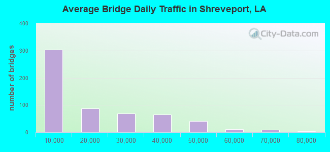
- 10,099,910Total average daily traffic
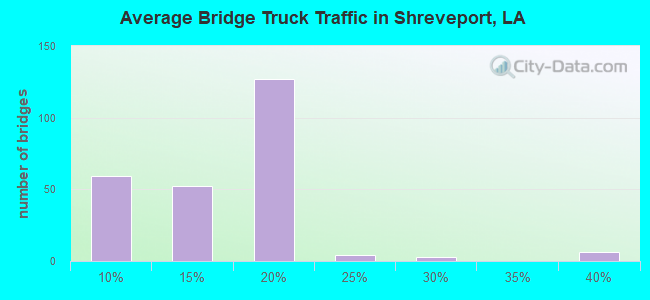
- 802,012Total average daily truck traffic
- National Bridge Inventory (NBI) Registered Bridges for Shreveport
- No street view available for this location
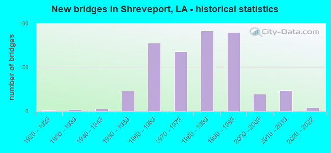
- New bridges - historical statistics
- 11920-1929
- 21930-1939
- 31940-1949
- 231950-1959
- 781960-1969
- 681970-1979
- 921980-1989
- 901990-1999
- 202000-2009
- 242010-2019
- 42020-2022
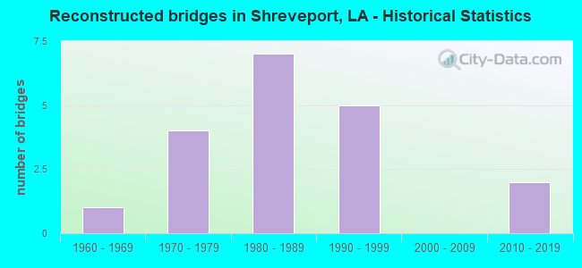
- Reconstructed bridges - Historical Statistics
- 11960-1969
- 41970-1979
- 71980-1989
- 51990-1999
- 02000-2009
- 22010-2019
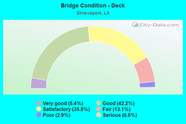
- Bridge Condition - Deck
- 5.4%Very good
- 42.2%Good
- 35.8%Satisfactory
- 13.1%Fair
- 2.9%Poor
- 0.6%Serious
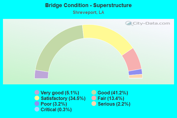
- Bridge Condition - Superstructure
- 5.1%Very good
- 41.2%Good
- 34.5%Satisfactory
- 13.4%Fair
- 3.2%Poor
- 2.2%Serious
- 0.3%Critical
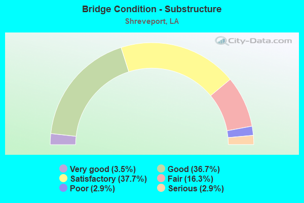
- Bridge Condition - Substructure
- 3.5%Very good
- 36.7%Good
- 37.7%Satisfactory
- 16.3%Fair
- 2.9%Poor
- 2.9%Serious
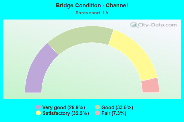
- Bridge Condition - Channel
- 26.9%Very good
- 33.5%Good
- 32.2%Satisfactory
- 7.3%Fair
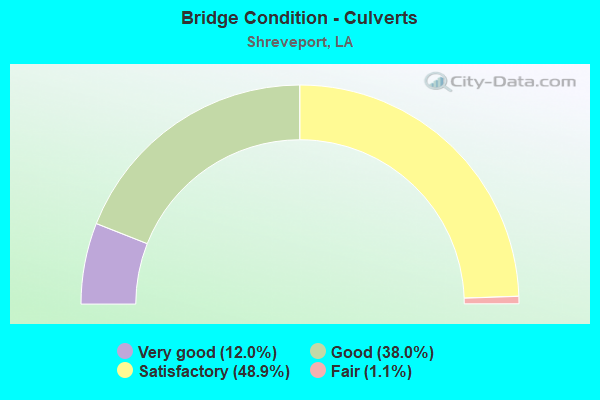
- Bridge Condition - Culverts
- 12.0%Very good
- 38.0%Good
- 48.9%Satisfactory
- 1.1%Fair
Find on map >> Show street view
Structure Number: 40932322935431, Location: 2.1 MI.SO. OF CADDO RD 4 (Lat: 32.536361, Lng: -93.904861), Route carried "on" structure: County highway , Year Built: 1982, Status: Open, Structure Length: 1.16m (3.81ft), Average Daily Traffic: 38 (year 2019), Average Future Daily Traffic: 5,630 (year 2036), Design Load: HS 20, Features Intersected: TRIBUTARY TO CROSS LAKE, Facility Carried by Structure: North Lakeshore Dr
Minimum Vertical Clearance: 30+ m (98+ ft), Kilometerpoint: 0.000, Lanes on structure: 2, Owner: County Highway Agency, Approaching Roadway Width: 12.2m (40.0ft), Material/Design: Concrete, Design/Construction: Slab, Number Of Spans In Main Unit: 2, Length of Maximum Span: 5.8m (19.0ft), Curb-To-Curb Width: 8.5m (27.9ft), Out-to-Out Width: 9.4m (30.8ft)
Condition: Deck: Good, Superstructure: Good, Substructure: Satisfactory, Channel: Good, Operating Rating: 24.3 metric tons, Method Used To Determine Operating Rating: Load and Resistance Factor Rating (LRFR) rating reported by rating factor(RF) method using HL-93 loadings, Inventory Rating: 18.8 metric tons, Method Used To Determine Inventory Rating: Load and Resistance Factor Rating (LRFR) rating reported by rating factor(RF) method using HL-93 loadings, Structural Evaluation: Somewhat better than minimum adequacy, Deck Geometry: Better than present minimum criteria, Waterway Adequacy: Somewhat better than minimum adequacy, Approach Roadway Alignment: Equal to present minimum criteria, Designated Inspection Frequency: Every 24 months, Inspection Date: March 2021, Deck Structure Type: Concrete Cast-file-Place
Find on map >> Show street view
Structure Number: 40932323935531, Location: 3.5 MI. SW OF BLANCHARD (Lat: 32.537850, Lng: -93.921650), Route carried "on" structure: County highway , Year Built: 1998, Status: Open, Structure Length: 3.05m (10.01ft), Average Daily Traffic: 100 (year 2019), Average Future Daily Traffic: 531 (year 2036), Design Load: HS 20, Features Intersected: SHETTLEWORTH BAYOU, Facility Carried by Structure: West Lakeshore Dr
Minimum Vertical Clearance: 30+ m (98+ ft), Kilometerpoint: 0.000, Lanes on structure: 2, Base Highway Network: Yes, Owner: County Highway Agency, Approaching Roadway Width: 8.2m (26.9ft), Material/Design: Concrete, Design/Construction: Slab, Number Of Spans In Main Unit: 6, Length of Maximum Span: 6.1m (20.0ft), Curb-To-Curb Width: 8.5m (27.9ft), Out-to-Out Width: 9.4m (30.8ft)
Condition: Deck: Good, Superstructure: Good, Substructure: Good, Channel: Satisfactory, Operating Rating: 25.3 metric tons, Method Used To Determine Operating Rating: Load and Resistance Factor Rating (LRFR) rating reported by rating factor(RF) method using HL-93 loadings, Inventory Rating: 19.8 metric tons, Method Used To Determine Inventory Rating: Load and Resistance Factor Rating (LRFR) rating reported by rating factor(RF) method using HL-93 loadings, Structural Evaluation: Somewhat better than minimum adequacy, Deck Geometry: Better than present minimum criteria, Waterway Adequacy: Equal to present desirable criteria, Approach Roadway Alignment: Equal to present minimum criteria, Designated Inspection Frequency: Every 24 months, Underwater Inspection Frequency: Every 60 months, Inspection Date: March 2021, Underwater Inspection Date: July 2020, Deck Structure Type: Concrete Cast-file-Place, Wearing Surface/Protective System: Wearing Surface: Wood or Timber
Find on map >> Show street view
Structure Number: 40932325935471, Location: WEST SIDE OF CROSS LAKE (Lat: 32.541231, Lng: -93.911681), Route carried "on" structure: County highway , Year Built: 2001, Status: Open, Structure Length: 1.16m (3.81ft), Average Daily Traffic: 38 (year 2019), Average Future Daily Traffic: 923 (year 2036), Design Load: HS 20, Features Intersected: TRIBUTARY TO CROSS LAKE, Facility Carried by Structure: West Lakeshore Dr
Minimum Vertical Clearance: 30+ m (98+ ft), Kilometerpoint: 0.000, Lanes on structure: 2, Base Highway Network: Yes, Owner: County Highway Agency, Approaching Roadway Width: 5.8m (19.0ft), Material/Design: Concrete, Design/Construction: Slab, Number Of Spans In Main Unit: 2, Length of Maximum Span: 5.8m (19.0ft), Curb-To-Curb Width: 8.6m (28.2ft), Out-to-Out Width: 9.4m (30.8ft)
Condition: Deck: Satisfactory, Superstructure: Satisfactory, Substructure: Good, Channel: Good, Operating Rating: 27.9 metric tons, Method Used To Determine Operating Rating: Load and Resistance Factor Rating (LRFR) rating reported by rating factor(RF) method using HL-93 loadings, Inventory Rating: 21.4 metric tons, Method Used To Determine Inventory Rating: Load and Resistance Factor Rating (LRFR) rating reported by rating factor(RF) method using HL-93 loadings, Structural Evaluation: Equal to present minimum criteria, Deck Geometry: Better than present minimum criteria, Waterway Adequacy: Meets minimum limits, Approach Roadway Alignment: Equal to present minimum criteria, Designated Inspection Frequency: Every 24 months, Inspection Date: March 2021, Deck Structure Type: Concrete Precast Panels
Find on map >> Show street view
Structure Number: 40932326934871, Location: 0.1 MI NORTH OF LA 3094 (Lat: 32.544561, Lng: -93.811511), Route carried "on" structure: County highway , Year Built: 1986, Status: Open, Structure Length: 2.10m (6.89ft), Average Daily Traffic: 1,352 (year 1979), Average Future Daily Traffic: 1,595 (year 2036), Design Load: HS 20, Features Intersected: COOPER ROAD DITCH, Facility Carried by Structure: LEGARDY STREET
Minimum Vertical Clearance: 30+ m (98+ ft), Kilometerpoint: 0.000, Lanes on structure: 2, Owner: City or Municipal Highway Agency, Approaching Roadway Width: 8.5m (27.9ft), Material/Design: Concrete, Design/Construction: Channel Beam, Number Of Spans In Main Unit: 3, Length of Maximum Span: 9.4m (30.8ft), Curb or Sidewalk Widths: Left: 0.0m, Right: 1.2m (3.9ft), Curb-To-Curb Width: 8.6m (28.2ft), Out-to-Out Width: 10.7m (35.1ft)
Condition: Deck: Satisfactory, Superstructure: Satisfactory, Substructure: Satisfactory, Channel: Good, Operating Rating: 49.2 metric tons, Method Used To Determine Operating Rating: Load and Resistance Factor Rating (LRFR) rating reported by rating factor(RF) method using HL-93 loadings, Inventory Rating: 32.4 metric tons, Method Used To Determine Inventory Rating: Load and Resistance Factor Rating (LRFR) rating reported by rating factor(RF) method using HL-93 loadings, Structural Evaluation: Equal to present minimum criteria, Deck Geometry: Somewhat better than minimum adequacy, Waterway Adequacy: Somewhat better than minimum adequacy, Approach Roadway Alignment: Better than present minimum criteria, Designated Inspection Frequency: Every 24 months, Inspection Date: April 2021, Deck Structure Type: Concrete Cast-file-Place
Find on map >> Show street view
Structure Number: 40932326934891, Location: 1.2 MI EAST OF LA 173 (Lat: 32.544289, Lng: -93.815839), Route carried "on" structure: County highway , Year Built: 1987, Status: Open, Structure Length: 2.10m (6.89ft), Average Daily Traffic: 600 (year 1979), Average Future Daily Traffic: 708 (year 2036), Design Load: HS 20, Features Intersected: COOPER ROAD DITCH, Facility Carried by Structure: LINEAR STREET
Minimum Vertical Clearance: 30+ m (98+ ft), Kilometerpoint: 0.000, Lanes on structure: 2, Owner: City or Municipal Highway Agency, Approaching Roadway Width: 7.0m (23.0ft), Material/Design: Concrete, Design/Construction: Channel Beam, Number Of Spans In Main Unit: 3, Length of Maximum Span: 9.4m (30.8ft), Curb or Sidewalk Widths: Left: 1.2m (3.9ft), Right: 0.0m, Curb-To-Curb Width: 8.5m (27.9ft), Out-to-Out Width: 10.8m (35.4ft)
Condition: Deck: Satisfactory, Superstructure: Fair, Substructure: Fair, Channel: Satisfactory, Operating Rating: 43.4 metric tons, Method Used To Determine Operating Rating: Load and Resistance Factor Rating (LRFR) rating reported by rating factor(RF) method using HL-93 loadings, Inventory Rating: 30.8 metric tons, Method Used To Determine Inventory Rating: Load and Resistance Factor Rating (LRFR) rating reported by rating factor(RF) method using HL-93 loadings, Structural Evaluation: Somewhat better than minimum adequacy, Deck Geometry: Somewhat better than minimum adequacy, Waterway Adequacy: Better than present minimum criteria, Approach Roadway Alignment: Better than present minimum criteria, Designated Inspection Frequency: Every 24 months, Inspection Date: April 2021, Deck Structure Type: Concrete Precast Panels, Wearing Surface/Protective System: Wearing Surface: Bituminous
Find on map >> Show street view
Structure Number: 40932327934911, Location: 0.11 MI WEST OF LINEAR ST (Lat: 32.545431, Lng: -93.817700), Route carried "on" structure: County highway , Year Built: 1996, Status: Open, Structure Length: 1.04m (3.41ft), Average Daily Traffic: 161 (year 2019), Average Future Daily Traffic: 177 (year 2039), Design Load: HS 20, Features Intersected: MARTIN L KING DR DITCH, Facility Carried by Structure: WILLIS STREET
Minimum Vertical Clearance: 30+ m (98+ ft), Kilometerpoint: 0.000, Lanes on structure: 2, Owner: City or Municipal Highway Agency, Approaching Roadway Width: 7.3m (24.0ft), Skew: 4 degrees, Material/Design: Concrete, Design/Construction: Culvert, Number Of Spans In Main Unit: 3, Length of Maximum Span: 3.0m (9.8ft), Curb-To-Curb Width: 7.3m (24.0ft), Out-to-Out Width: 52.0m (170.6ft)
Condition: Channel: Satisfactory, Culverts: Good, Operating Rating: 40.8 metric tons, Method Used To Determine Operating Rating: Load and Resistance Factor Rating (LRFR) rating reported by rating factor(RF) method using HL-93 loadings, Inventory Rating: 31.4 metric tons, Method Used To Determine Inventory Rating: Load and Resistance Factor Rating (LRFR) rating reported by rating factor(RF) method using HL-93 loadings, Structural Evaluation: Better than present minimum criteria, Deck Geometry: Somewhat better than minimum adequacy, Waterway Adequacy: Equal to present desirable criteria, Approach Roadway Alignment: Equal to present desirable criteria, Designated Inspection Frequency: Every 24 months, Inspection Date: April 2021, Deck Structure Type: Concrete Cast-file-Place
Find on map >> Show street view
Structure Number: 40932328934841, Location: 0.3 MI. NORTH OF LA 3194 (Lat: 32.547419, Lng: -93.807200), Route carried "on" structure: County highway , Year Built: 1984, Status: Open, Structure Length: 1.74m (5.71ft), Average Daily Traffic: 580 (year 1979), Average Future Daily Traffic: 684 (year 2036), Design Load: HS 20, Features Intersected: COOPER ROAD DITCH, Facility Carried by Structure: JONES MABRY ROAD
Minimum Vertical Clearance: 30+ m (98+ ft), Kilometerpoint: 0.000, Lanes on structure: 2, Owner: City or Municipal Highway Agency, Approaching Roadway Width: 8.2m (26.9ft), Material/Design: Concrete, Design/Construction: Slab, Number Of Spans In Main Unit: 3, Length of Maximum Span: 5.8m (19.0ft), Curb or Sidewalk Widths: Left: 0.0m, Right: 1.2m (3.9ft), Curb-To-Curb Width: 8.7m (28.5ft), Out-to-Out Width: 10.7m (35.1ft)
Condition: Deck: Satisfactory, Superstructure: Satisfactory, Substructure: Fair, Channel: Fair, Operating Rating: 41.8 metric tons, Method Used To Determine Operating Rating: Load and Resistance Factor Rating (LRFR) rating reported by rating factor(RF) method using HL-93 loadings, Inventory Rating: 32.4 metric tons, Method Used To Determine Inventory Rating: Load and Resistance Factor Rating (LRFR) rating reported by rating factor(RF) method using HL-93 loadings, Structural Evaluation: Somewhat better than minimum adequacy, Deck Geometry: Somewhat better than minimum adequacy, Waterway Adequacy: Better than present minimum criteria, Approach Roadway Alignment: Better than present minimum criteria, Designated Inspection Frequency: Every 24 months, Inspection Date: April 2021, Deck Structure Type: Concrete Precast Panels, Wearing Surface/Protective System: Wearing Surface: Bituminous
Find on map >> Show street view
Structure Number: 40932328934911, Location: 0.43 MI WEST OF LEGARDY S (Lat: 32.547211, Lng: -93.818900), Route carried "on" structure: County highway , Year Built: 1996, Status: Open, Structure Length: 0.73m (2.40ft), Average Daily Traffic: 852 (year 2019), Average Future Daily Traffic: 937 (year 2039), Design Load: HS 20, Features Intersected: MARTIN L KING DRIVE DITC, Facility Carried by Structure: WILLIE MAYS STREET
Minimum Vertical Clearance: 30+ m (98+ ft), Kilometerpoint: 0.000, Lanes on structure: 2, Owner: City or Municipal Highway Agency, Approaching Roadway Width: 7.3m (24.0ft), Skew: 2 degrees, Material/Design: Concrete, Design/Construction: Culvert, Number Of Spans In Main Unit: 2, Length of Maximum Span: 3.0m (9.8ft), Curb-To-Curb Width: 7.3m (24.0ft), Out-to-Out Width: 24.6m (80.7ft)
Condition: Channel: Good, Culverts: Good, Operating Rating: 42.1 metric tons, Method Used To Determine Operating Rating: Load and Resistance Factor Rating (LRFR) rating reported by rating factor(RF) method using HL-93 loadings, Inventory Rating: 32.4 metric tons, Method Used To Determine Inventory Rating: Load and Resistance Factor Rating (LRFR) rating reported by rating factor(RF) method using HL-93 loadings, Structural Evaluation: Better than present minimum criteria, Deck Geometry: Meets minimum limits, Waterway Adequacy: Equal to present desirable criteria, Approach Roadway Alignment: Equal to present desirable criteria, Designated Inspection Frequency: Every 24 months, Inspection Date: April 2021, Deck Structure Type: Concrete Cast-file-Place
Find on map >> Show street view
Structure Number: 40932330934811, Location: 0.2 M N OF LA3194 (Lat: 32.549861, Lng: -93.801150), Route carried "on" structure: County highway , Year Built: 1982, Status: Open, Structure Length: 1.80m (5.91ft), Average Daily Traffic: 650 (year 1979), Average Future Daily Traffic: 767 (year 2036), Design Load: HS 20, Features Intersected: COOPER ROAD DITCH, Facility Carried by Structure: MONTANA ST
Minimum Vertical Clearance: 30+ m (98+ ft), Kilometerpoint: 0.000, Lanes on structure: 2, Owner: City or Municipal Highway Agency, Approaching Roadway Width: 9.1m (29.9ft), Material/Design: Concrete, Design/Construction: Slab, Number Of Spans In Main Unit: 3, Length of Maximum Span: 5.8m (19.0ft), Curb or Sidewalk Widths: Left: 0.0m, Right: 1.2m (3.9ft), Curb-To-Curb Width: 8.6m (28.2ft), Out-to-Out Width: 9.4m (30.8ft)
Condition: Deck: Satisfactory, Superstructure: Satisfactory, Substructure: Fair, Channel: Satisfactory, Operating Rating: 31.8 metric tons, Method Used To Determine Operating Rating: Load and Resistance Factor Rating (LRFR) rating reported by rating factor(RF) method using HL-93 loadings, Inventory Rating: 24.6 metric tons, Method Used To Determine Inventory Rating: Load and Resistance Factor Rating (LRFR) rating reported by rating factor(RF) method using HL-93 loadings, Structural Evaluation: Somewhat better than minimum adequacy, Deck Geometry: Somewhat better than minimum adequacy, Waterway Adequacy: Meets minimum limits, Approach Roadway Alignment: Equal to present minimum criteria, Designated Inspection Frequency: Every 24 months, Inspection Date: April 2021, Deck Structure Type: Concrete Precast Panels, Wearing Surface/Protective System: Wearing Surface: Bituminous
Find on map >> Show street view
Structure Number: 40932338935661, Location: BLANCHARD FURRH ROAD (Lat: 32.563661, Lng: -93.943331), Route carried "on" structure: County highway , Year Built: 1978, Status: Open, Structure Length: 2.35m (7.71ft), Average Daily Traffic: 77 (year 2019), Average Future Daily Traffic: 1,014 (year 2036), Design Load: HS 20, Features Intersected: TRIB. TO SHETTLEWORTH BY, Facility Carried by Structure: BLANCHARD FURRH RD
Minimum Vertical Clearance: 30+ m (98+ ft), Kilometerpoint: 0.000, Lanes on structure: 2, Owner: County Highway Agency, Approaching Roadway Width: 12.8m (42.0ft), Material/Design: Concrete, Design/Construction: Slab, Number Of Spans In Main Unit: 4, Length of Maximum Span: 5.8m (19.0ft), Curb-To-Curb Width: 8.6m (28.2ft), Out-to-Out Width: 9.5m (31.2ft)
Condition: Deck: Satisfactory, Superstructure: Satisfactory, Substructure: Satisfactory, Channel: Satisfactory, Operating Rating: 38.6 metric tons, Method Used To Determine Operating Rating: Load and Resistance Factor Rating (LRFR) rating reported by rating factor(RF) method using HL-93 loadings, Inventory Rating: 29.5 metric tons, Method Used To Determine Inventory Rating: Load and Resistance Factor Rating (LRFR) rating reported by rating factor(RF) method using HL-93 loadings, Structural Evaluation: Equal to present minimum criteria, Deck Geometry: Better than present minimum criteria, Waterway Adequacy: Meets minimum limits, Approach Roadway Alignment: Better than present minimum criteria, Designated Inspection Frequency: Every 24 months, Inspection Date: March 2021, Deck Structure Type: Concrete Precast Panels, Wearing Surface/Protective System: Wearing Surface: Bituminous
Find on map >> Show street view
Structure Number: 40932343935081, Location: 1.4 MI. NO. OF LA 173 (Lat: 32.572419, Lng: -93.846481), Route carried "on" structure: County highway , Year Built: 1982, Status: Open, Structure Length: 1.80m (5.91ft), Average Daily Traffic: 200 (year 2019), Average Future Daily Traffic: 1,817 (year 2036), Design Load: HS 20, Features Intersected: LOGAN BAYOU, Facility Carried by Structure: Roy Rd
Minimum Vertical Clearance: 30+ m (98+ ft), Kilometerpoint: 0.000, Lanes on structure: 2, Owner: County Highway Agency, Approaching Roadway Width: 8.5m (27.9ft), Material/Design: Concrete, Design/Construction: Slab, Number Of Spans In Main Unit: 3, Length of Maximum Span: 5.8m (19.0ft), Curb-To-Curb Width: 8.6m (28.2ft), Out-to-Out Width: 9.4m (30.8ft)
Condition: Deck: Good, Superstructure: Good, Substructure: Good, Channel: Satisfactory, Operating Rating: 26.9 metric tons, Method Used To Determine Operating Rating: Load and Resistance Factor Rating (LRFR) rating reported by rating factor(RF) method using HL-93 loadings, Inventory Rating: 20.7 metric tons, Method Used To Determine Inventory Rating: Load and Resistance Factor Rating (LRFR) rating reported by rating factor(RF) method using HL-93 loadings, Structural Evaluation: Equal to present minimum criteria, Deck Geometry: Equal to present minimum criteria, Waterway Adequacy: Somewhat better than minimum adequacy, Approach Roadway Alignment: Equal to present minimum criteria, Designated Inspection Frequency: Every 24 months, Inspection Date: March 2021, Deck Structure Type: Concrete Precast Panels, Wearing Surface/Protective System: Wearing Surface: Bituminous
Find on map >> Show street view
Structure Number: 40804510215501, Location: 2.8 MI W OF B.P LINE (Lat: 32.566211, Lng: -93.492489), Route carried "under" structure: Interstate 20, Structure Length: 0. m, Average Daily Traffic: 33,840 (year 2015), Features Intersected: 79 EB UNDER I-20 EB
Minimum Vertical Clearance: 4.63m (15.19ft), Kilometerpoint: 25.338, Lanes on structure: 2, Length of Maximum Span: 0.0m
Find on map >> Show street view
Structure Number: 40804510215501, Location: 2.8 MI W OF B.P LINE (Lat: 32.566511, Lng: -93.492081), Route carried "under" structure: Interstate 20, Structure Length: 0. m, Average Daily Traffic: 33,840 (year 2015), Features Intersected: 79 WB UNDER I-20 WB
Minimum Vertical Clearance: 4.63m (15.19ft), Kilometerpoint: 4.352, Lanes on structure: 2, Length of Maximum Span: 0.0m
Find on map >> Show street view
Structure Number: 40804510215502, Location: 2.8 MI W OF B.P LINE (Lat: 32.566339, Lng: -93.492761), Route carried "under" structure: Interstate 20, Structure Length: 0. m, Average Daily Traffic: 33,840 (year 2015), Features Intersected: 79 WB UNDER I-20 WB
Minimum Vertical Clearance: 4.60m (15.09ft), Kilometerpoint: 4.418, Lanes on structure: 2, Length of Maximum Span: 0.0m
Find on map >> Show street view
Structure Number: 40804510215502, Location: 2.8 MI W OF B.P LINE (Lat: 32.566061, Lng: -93.493150), Route carried "under" structure: Interstate 20, Structure Length: 0. m, Average Daily Traffic: 33,840 (year 2015), Features Intersected: 79 EB UNDER I-20 WB
Minimum Vertical Clearance: 4.94m (16.21ft), Kilometerpoint: 25.273, Lanes on structure: 2, Length of Maximum Span: 0.0m
Find on map >> Show street view
Structure Number: 40804513100001, Location: .30 MILES EAST OF LA 538 (Lat: 32.556600, Lng: -93.769050), Route carried "under" structure: Interstate 220, Structure Length: 0. m, Average Daily Traffic: 44,700 (year 2015), Features Intersected: 220 OVER 3049
Minimum Vertical Clearance: 12.65m (41.50ft), Kilometerpoint: 3.217, Lanes on structure: 2, Length of Maximum Span: 0.0m
Find on map >> Show street view
Structure Number: 40804513100001, Location: .5 MILES EAST OF US 71 (Lat: 32.556731, Lng: -93.773600), Route carried "under" structure: Interstate 220, Structure Length: 0. m, Average Daily Traffic: 44,700 (year 2015), Features Intersected: 220 OVER 538
Minimum Vertical Clearance: 5.09m (16.70ft), Kilometerpoint: 0.335, Lanes on structure: 2, Length of Maximum Span: 0.0m
Find on map >> Show street view
Structure Number: 40900000040334, Location: 0.6 MI. W. OF LA 1 (Lat: 32.538139, Lng: -93.793911), Route carried "under" structure: State highway 3194, Structure Length: 0. m, Average Daily Traffic: 9,900 (year 2016), Truck Traffic: 9%, Features Intersected: LA 3194 UNDER I-49
Minimum Vertical Clearance: 5.30m (17.39ft), Kilometerpoint: 4.377, Lanes on structure: 4, Lanes under structure: 4, Length of Maximum Span: 0.0m
Find on map >> Show street view
Structure Number: 40900000040335, Location: 2.7 MI. E OF LA 173 (Lat: 32.538139, Lng: -93.793911), Route carried "under" structure: State highway 3194, Structure Length: 0. m, Average Daily Traffic: 9,900 (year 2016), Truck Traffic: 9%, Features Intersected: LA 3194 EB UNDER I-49
Minimum Vertical Clearance: 5.40m (17.72ft), Kilometerpoint: 4.363, Lanes on structure: 2, Lanes under structure: 4, Length of Maximum Span: 0.0m
Find on map >> Show street view
Structure Number: 40900000040336, Location: I-49 @ I-220 INTERCHANGE (Lat: 32.537150, Lng: -93.794719), Route carried "under" structure: Interstate 220, Structure Length: 0. m, Average Daily Traffic: 32,000 (year 2013), Truck Traffic: 15%, Features Intersected: I-220 EB UNDER I-49 N ON
Minimum Vertical Clearance: 7.99m (26.21ft), Kilometerpoint: 10.292, Lanes on structure: 2, Lanes under structure: 2, Length of Maximum Span: 0.0m
Find on map >> Show street view
Structure Number: 40900000040336, Location: I-49 @ I-220 INTERCHANGE (Lat: 32.538161, Lng: -93.794281), Route carried "under" structure: Interstate 220, Structure Length: 0. m, Average Daily Traffic: 32,000 (year 2013), Truck Traffic: 15%, Features Intersected: I-220 WB UNDER I-49 N ON
Minimum Vertical Clearance: 9.85m (32.32ft), Kilometerpoint: 2.902, Lanes on structure: 2, Lanes under structure: 2, Length of Maximum Span: 0.0m
Find on map >> Show street view
Structure Number: 40900000040337, Location: I-49 @ I-220 INTERCHANGE (Lat: 32.536489, Lng: -93.795189), Route carried "under" structure: Ramp Interstate 49, Structure Length: 0. m, Average Daily Traffic: 2,287 (year 2013), Truck Traffic: 14%, Features Intersected: I-49N FROM I-220E UNDER
Minimum Vertical Clearance: 6.58m (21.59ft), Lanes on structure: 1, Lanes under structure: 2, Length of Maximum Span: 0.0m
Find on map >> Show street view
Structure Number: 40900000040337, Location: I-49 @ i-220 INTERCHANGE (Lat: 32.536589, Lng: -93.795481), Route carried "under" structure: Interstate 220, Structure Length: 0. m, Average Daily Traffic: 34,116 (year 2015), Truck Traffic: 14%, Features Intersected: I-220 WB UNDER I-49S TO
Minimum Vertical Clearance: 19.69m (64.60ft), Kilometerpoint: 3.104, Lanes on structure: 1, Lanes under structure: 2, Length of Maximum Span: 0.0m
Find on map >> Show street view
Structure Number: 40900000040337, Location: I-49 @ I-220 INTERCHANGE (Lat: 32.537069, Lng: -93.796119), Route carried "under" structure: Ramp Interstate 49, Structure Length: 0. m, Average Daily Traffic: 2,287 (year 2013), Truck Traffic: 14%, Features Intersected: I-49S TO I-220W UNDER I-
Minimum Vertical Clearance: 16.58m (54.40ft), Lanes on structure: 1, Lanes under structure: 2, Length of Maximum Span: 0.0m
Find on map >> Show street view
Structure Number: 40900010203241, Location: .15 MILES NORTH OF I20 (Lat: 32.458461, Lng: -93.845369), Route carried "under" structure: Interstate 220, Structure Length: 0. m, Average Daily Traffic: 4,200 (year 2015), Features Intersected: 79 OVER 220 EAST
Minimum Vertical Clearance: 5.43m (17.81ft), Kilometerpoint: 0.274, Lanes on structure: 2, Length of Maximum Span: 0.0m
Find on map >> Show street view
Structure Number: 40900010203241, Location: .15 MILES NORTH OF I20 (Lat: 32.458531, Lng: -93.845631), Route carried "under" structure: Interstate 220, Structure Length: 0. m, Average Daily Traffic: 4,200 (year 2015), Features Intersected: 79 OVER 220 WEST
Minimum Vertical Clearance: 5.18m (16.99ft), Kilometerpoint: 13.074, Lanes on structure: 2, Length of Maximum Span: 0.0m
Find on map >> Show street view
Structure Number: 40900010203241, Location: .15 MILES NORTH OF I20 (Lat: 32.457919, Lng: -93.846589), Route carried "under" structure: Interstate 220, Structure Length: 0. m, Average Daily Traffic: 4,200 (year 2015), Features Intersected: 79 OVER RAMP TO 220 EAST
Minimum Vertical Clearance: 5.06m (16.60ft), Kilometerpoint: 0.671, Lanes on structure: 2, Length of Maximum Span: 0.0m
Find on map >> Show street view
Structure Number: 40900010203241, Location: .15 MILES NORTH OF I20 (Lat: 32.457819, Lng: -93.847200), Route carried "under" structure: Interstate 220, Structure Length: 0. m, Average Daily Traffic: 4,200 (year 2015), Features Intersected: 79 OVER 220 EAST R TO I2
Minimum Vertical Clearance: 5.49m (18.01ft), Kilometerpoint: 0.904, Lanes on structure: 2, Length of Maximum Span: 0.0m
Find on map >> Show street view
Structure Number: 40900010209861, Location: 0.3 MI E OF I-49 (Lat: 32.498261, Lng: -93.755219), Route carried "under" structure: Ramp Interstate 20, Structure Length: 0. m, Average Daily Traffic: 11,500 (year 2017), Features Intersected: I-49 OFF RAMP TO I-20 EB
Minimum Vertical Clearance: 6.13m (20.11ft), Kilometerpoint: 1.144, Lanes on structure: 3, Lanes under structure: 2, Length of Maximum Span: 0.0m
Find on map >> Show street view
Structure Number: 40900010209861, Location: 0.3 MI E OF I-49 (Lat: 32.498700, Lng: -93.754911), Route carried "under" structure: Interstate 20, Structure Length: 0. m, Average Daily Traffic: 57,500 (year 2017), Features Intersected: I-20 WB UNDER US 80 (TEX
Minimum Vertical Clearance: 6.89m (22.60ft), Kilometerpoint: 2.074, Lanes on structure: 3, Lanes under structure: 3, Length of Maximum Span: 0.0m
Find on map >> Show street view
Structure Number: 40900010209861, Location: 0.3 MI E OF I-49 (Lat: 32.498831, Lng: -93.754881), Route carried "under" structure: Ramp Interstate 20, Structure Length: 0. m, Average Daily Traffic: 11,500 (year 2017), Features Intersected: I-20 WB OFF RAMP TO I-49
Minimum Vertical Clearance: 7.89m (25.89ft), Kilometerpoint: 0.074, Lanes on structure: 3, Lanes under structure: 2, Length of Maximum Span: 0.0m
Find on map >> Show street view
Structure Number: 40900010209861, Location: 0.3 MI E OF I-49 (Lat: 32.498411, Lng: -93.755189), Route carried "under" structure: Interstate 20, Structure Length: 0. m, Average Daily Traffic: 57,500 (year 2017), Features Intersected: I-20 EB UNDER US 80 (TEX
Minimum Vertical Clearance: 6.25m (20.51ft), Kilometerpoint: 29.102, Lanes on structure: 3, Lanes under structure: 3, Length of Maximum Span: 0.0m
Find on map >> Show street view
Structure Number: 40900110200212, Location: 2.2 MI N OF I-220 (Lat: 32.581989, Lng: -93.799561), Route carried "under" structure: State highway 1, Structure Length: 0. m, Average Daily Traffic: 23,000 (year 2017), Features Intersected: LA 1 NB UNDER US 71 SB
Minimum Vertical Clearance: 5.18m (16.99ft), Kilometerpoint: 0.286, Lanes on structure: 1, Lanes under structure: 2, Length of Maximum Span: 0.0m
Find on map >> Show street view
Structure Number: 40900530908035, Location: 0.5 MI S OF I-20 (Lat: 32.504281, Lng: -93.736700), Route carried "under" structure: State highway 1, Structure Length: 0. m, Average Daily Traffic: 12,850 (year 2017), Features Intersected: LA 1 SB UNDER CROSSOVER
Minimum Vertical Clearance: 4.72m (15.49ft), Kilometerpoint: 1.526, Lanes on structure: 1, Lanes under structure: 2, Length of Maximum Span: 0.0m
Find on map >> Show street view
Structure Number: 40904270100941, Location: 3.3 MI E OF LA 526 (Lat: 32.442181, Lng: -93.842119), Route carried "under" structure: State highway 511, Structure Length: 0. m, Average Daily Traffic: 2,400 (year 2017), Features Intersected: LA 511 WB UNDER LA 3132
Minimum Vertical Clearance: 5.33m (17.49ft), Kilometerpoint: 6.735, Lanes on structure: 2, Lanes under structure: 3, Length of Maximum Span: 0.0m
Find on map >> Show street view
Structure Number: 40904270100941, Location: 3.3 MI E OF LA 526 (Lat: 32.442039, Lng: -93.842231), Route carried "under" structure: State highway 511, Structure Length: 0. m, Average Daily Traffic: 2,400 (year 2017), Features Intersected: LA 511 EB UNDER LA 3132
Minimum Vertical Clearance: 5.49m (18.01ft), Kilometerpoint: 10.346, Lanes on structure: 2, Lanes under structure: 3, Length of Maximum Span: 0.0m
Find on map >> Show street view
Structure Number: 40904270100942, Location: 3.3 MI E OF LA 526 (Lat: 32.442181, Lng: -93.841819), Route carried "under" structure: State highway 511, Structure Length: 0. m, Average Daily Traffic: 2,400 (year 2017), Features Intersected: LA 511 WB UNDER LA 3132
Minimum Vertical Clearance: 5.82m (19.09ft), Kilometerpoint: 6.706, Lanes on structure: 2, Lanes under structure: 3, Length of Maximum Span: 0.0m
Find on map >> Show street view
Structure Number: 40904270100942, Location: 3.3 MI E OF LA 526 (Lat: 32.442039, Lng: -93.841931), Route carried "under" structure: State highway 511, Structure Length: 0. m, Average Daily Traffic: 2,400 (year 2017), Features Intersected: LA 511 EB UNDER LA 3132
Minimum Vertical Clearance: 5.85m (19.19ft), Kilometerpoint: 10.375, Lanes on structure: 2, Lanes under structure: 3, Length of Maximum Span: 0.0m
Find on map >> Show street view
Structure Number: 40904270105141, Location: 1.2 MI N OF LA 526 (Lat: 32.415831, Lng: -93.789789), Route carried "under" structure: US 171, Structure Length: 0. m, Average Daily Traffic: 8,850 (year 2017), Features Intersected: US 171 SB UNDER LA 3132
Minimum Vertical Clearance: 6.77m (22.21ft), Kilometerpoint: 10.924, Lanes on structure: 2, Lanes under structure: 2, Length of Maximum Span: 0.0m
Find on map >> Show street view
Structure Number: 40904270105141, Location: 1.2 MI N OF LA 526 (Lat: 32.415689, Lng: -93.789700), Route carried "under" structure: US 171, Structure Length: 0. m, Average Daily Traffic: 8,850 (year 2017), Features Intersected: US 171 NB UNDER LA 3132
Minimum Vertical Clearance: 6.95m (22.80ft), Kilometerpoint: 13.964, Lanes on structure: 2, Lanes under structure: 2, Length of Maximum Span: 0.0m
Find on map >> Show street view
Structure Number: 40904270105142, Location: 1.2 MI N OF LA 526 (Lat: 32.416119, Lng: -93.789511), Route carried "under" structure: US 171, Structure Length: 0. m, Average Daily Traffic: 8,850 (year 2017), Features Intersected: US 171 SB UNDER LA 3132
Minimum Vertical Clearance: 6.71m (22.01ft), Kilometerpoint: 10.882, Lanes on structure: 3, Lanes under structure: 2, Length of Maximum Span: 0.0m
Find on map >> Show street view
Structure Number: 40904270105142, Location: 1.2 MI N OF LA 526 (Lat: 32.415900, Lng: -93.789481), Route carried "under" structure: US 171, Structure Length: 0. m, Average Daily Traffic: 8,850 (year 2017), Features Intersected: US 171 NB UNDER LA 3132
Minimum Vertical Clearance: 6.16m (20.21ft), Kilometerpoint: 13.995, Lanes on structure: 3, Lanes under structure: 2, Length of Maximum Span: 0.0m
Find on map >> Show street view
Structure Number: 40904270105761, Location: 0.5 MI E OF US 171 (Lat: 32.418050, Lng: -93.780169), Route carried "under" structure: State highway 3132, Structure Length: 0. m, Average Daily Traffic: 24,300 (year 2017), Features Intersected: LA 3132 WB UNDER KINGSTO
Minimum Vertical Clearance: 5.18m (16.99ft), Kilometerpoint: 7.224, Lanes on structure: 2, Lanes under structure: 2, Length of Maximum Span: 0.0m
Find on map >> Show street view
Structure Number: 40904270105761, Location: 0.5 MI E OF US 171 (Lat: 32.417689, Lng: -93.780361), Route carried "under" structure: State highway 3132, Structure Length: 0. m, Average Daily Traffic: 24,300 (year 2017), Features Intersected: LA 3132 EB UNDER KINGSTO
Minimum Vertical Clearance: 5.03m (16.50ft), Kilometerpoint: 9.296, Lanes on structure: 2, Lanes under structure: 2, Length of Maximum Span: 0.0m
Find on map >> Show street view
Structure Number: 40904270107351, Location: 0.2 MI W OF I-49 (Lat: 32.420111, Lng: -93.754469), Route carried "under" structure: Ramp Interstate 49, Structure Length: 0. m, Average Daily Traffic: 4,180 (year 2017), Features Intersected: I-49 OFF RAMP TO LA 3132
Minimum Vertical Clearance: 5.27m (17.29ft), Kilometerpoint: 0.999, Lanes on structure: 4, Lanes under structure: 2, Length of Maximum Span: 0.0m
Find on map >> Show street view
Structure Number: 40904270107351, Location: 0.2 MI W OF I-49 (Lat: 32.419811, Lng: -93.754131), Route carried "under" structure: State highway 3132, Structure Length: 0. m, Average Daily Traffic: 22,550 (year 2017), Features Intersected: LA 3132 WB UNDER ST. VIN
Minimum Vertical Clearance: 6.86m (22.51ft), Kilometerpoint: 4.703, Lanes on structure: 4, Lanes under structure: 2, Length of Maximum Span: 0.0m
Find on map >> Show street view
Structure Number: 40904270107351, Location: 0.2 MI W OF I-49 (Lat: 32.419561, Lng: -93.754111), Route carried "under" structure: State highway 3132, Structure Length: 0. m, Average Daily Traffic: 22,550 (year 2017), Features Intersected: LA 3231 EB UNDER ST. VIN
Minimum Vertical Clearance: 5.61m (18.41ft), Kilometerpoint: 11.840, Lanes on structure: 4, Lanes under structure: 2, Length of Maximum Span: 0.0m
Find on map >> Show street view
Structure Number: 40904270108361, Location: 1.0 MI N OF LA 526 (Lat: 32.415911, Lng: -93.737500), Route carried "under" structure: State highway 523, Structure Length: 0. m, Average Daily Traffic: 7,000 (year 2017), Features Intersected: LA 523 SB UNDER LA 3132
Minimum Vertical Clearance: 5.36m (17.59ft), Kilometerpoint: 3.220, Lanes on structure: 2, Lanes under structure: 2, Length of Maximum Span: 0.0m
Find on map >> Show street view
Structure Number: 40904270108361, Location: 1.0 MI N OF LA 526 (Lat: 32.415711, Lng: -93.737400), Route carried "under" structure: State highway 523, Structure Length: 0. m, Average Daily Traffic: 7,000 (year 2017), Features Intersected: LA 523 NB UNDER LA 3132
Minimum Vertical Clearance: 5.24m (17.19ft), Kilometerpoint: 6.201, Lanes on structure: 2, Lanes under structure: 3, Length of Maximum Span: 0.0m
Find on map >> Show street view
Structure Number: 40904270108362, Location: 1.0 MI N OF LA 526 (Lat: 32.416139, Lng: -93.737419), Route carried "under" structure: State highway 523, Structure Length: 0. m, Average Daily Traffic: 7,000 (year 2017), Features Intersected: LA 523 SB UNDER LA 3123
Minimum Vertical Clearance: 5.82m (19.09ft), Kilometerpoint: 3.193, Lanes on structure: 2, Lanes under structure: 2, Length of Maximum Span: 0.0m
Find on map >> Show street view
Structure Number: 40904270108362, Location: 1.0 MI N OF LA 526 (Lat: 32.415981, Lng: -93.737300), Route carried "under" structure: State highway 523, Structure Length: 0. m, Average Daily Traffic: 7,000 (year 2017), Features Intersected: LA 523 NB UNDER LA 3132
Minimum Vertical Clearance: 5.82m (19.09ft), Kilometerpoint: 6.231, Lanes on structure: 2, Lanes under structure: 3, Length of Maximum Span: 0.0m
Find on map >> Show street view
Structure Number: 40904270109081, Location: 2.0 MI E OF I-49 (Lat: 32.411500, Lng: -93.724850), Route carried "under" structure: State highway 526, Structure Length: 0. m, Average Daily Traffic: 24,800 (year 2017), Features Intersected: LA 526 SB UNDER LA 3132
Minimum Vertical Clearance: 5.33m (17.49ft), Kilometerpoint: 4.554, Lanes on structure: 2, Lanes under structure: 3, Length of Maximum Span: 0.0m
Find on map >> Show street view
Structure Number: 40904270109081, Location: 2.0 MI E OF I-49 (Lat: 32.411339, Lng: -93.724750), Route carried "under" structure: State highway 526, Structure Length: 0. m, Average Daily Traffic: 24,800 (year 2017), Features Intersected: LA 526 NB UNDER LA 3132
Minimum Vertical Clearance: 5.55m (18.21ft), Kilometerpoint: 21.150, Lanes on structure: 2, Lanes under structure: 3, Length of Maximum Span: 0.0m
Find on map >> Show street view
Structure Number: 40904270109082, Location: 2.0 MI E OF I-49 (Lat: 32.411739, Lng: -93.724750), Route carried "under" structure: State highway 526, Structure Length: 0. m, Average Daily Traffic: 24,800 (year 2017), Features Intersected: LA 526 SB UNDER LA 3132
Minimum Vertical Clearance: 5.36m (17.59ft), Kilometerpoint: 4.525, Lanes on structure: 2, Lanes under structure: 3, Length of Maximum Span: 0.0m
Find on map >> Show street view
Structure Number: 40904270109082, Location: 2.0 MI E OF I- 49 (Lat: 32.411581, Lng: -93.724650), Route carried "under" structure: State highway 526, Structure Length: 0. m, Average Daily Traffic: 24,800 (year 2017), Features Intersected: LA 526 NB UNDER LA 3132
Minimum Vertical Clearance: 5.58m (18.31ft), Kilometerpoint: 21.179, Lanes on structure: 2, Lanes under structure: 3, Length of Maximum Span: 0.0m
Find on map >> Show street view
Structure Number: 40904510110601, Location: 2.0 MI E OF LA 526 (Lat: 32.450750, Lng: -93.865400), Route carried "under" structure: Interstate 20, Structure Length: 0. m, Average Daily Traffic: 71,600 (year 2014), Features Intersected: I-20 WB @ PINES RD
Minimum Vertical Clearance: 5.27m (17.29ft), Kilometerpoint: 14.120, Lanes on structure: 2, Length of Maximum Span: 0.0m
Find on map >> Show street view
Structure Number: 40904510110601, Location: 2.0 MI E OF LA 526 (Lat: 32.450400, Lng: -93.865769), Route carried "under" structure: Interstate 20, Structure Length: 0. m, Average Daily Traffic: 71,600 (year 2014), Features Intersected: I-20 EB @ PINES RD
Minimum Vertical Clearance: 5.21m (17.09ft), Kilometerpoint: 17.046, Lanes on structure: 2, Length of Maximum Span: 0.0m
Find on map >> Show street view
Structure Number: 40904510111687, Location: I-20/I-220 INTERCHANGE (Lat: 32.455061, Lng: -93.847631), Route carried "under" structure: Interstate 20, Structure Length: 0. m, Average Daily Traffic: 35,850 (year 2017), Features Intersected: I-20 EB UNDER I-20 EB OF
Minimum Vertical Clearance: 5.79m (19.00ft), Kilometerpoint: 18.834, Lanes on structure: 1, Lanes under structure: 2, Length of Maximum Span: 0.0m
Find on map >> Show street view
Structure Number: 40904510111687, Location: I-20/I-220 INTERCHANGE (Lat: 32.455450, Lng: -93.847269), Route carried "under" structure: Interstate 20, Structure Length: 0. m, Average Daily Traffic: 35,850 (year 2017), Features Intersected: I-20 WB UNDER I-20 EB OF
Minimum Vertical Clearance: 6.74m (22.11ft), Kilometerpoint: 12.331, Lanes on structure: 1, Lanes under structure: 2, Length of Maximum Span: 0.0m
Find on map >> Show street view
Structure Number: 40904510111687, Location: I-20/ I-220 INTERCHANGE (Lat: 32.456081, Lng: -93.847061), Route carried "under" structure: Ramp Interstate 20, Structure Length: 0. m, Average Daily Traffic: 7,170 (year 2017), Features Intersected: LA 3132 NB OFF RAMP TO I, Facility Carried by Structure: LA 3132 OFF RAMP
Minimum Vertical Clearance: 5.49m (18.01ft), Kilometerpoint: 0.953, Lanes on structure: 1, Lanes under structure: 1, Length of Maximum Span: 0.0m
Find on map >> Show street view
Structure Number: 40904510111816, Location: I-20/I-220 INTERCHANGE (Lat: 32.456039, Lng: -93.845381), Route carried "under" structure: Interstate 20, Structure Length: 0. m, Average Daily Traffic: 35,850 (year 2017), Features Intersected: I-20 WB UNDER LA 3132 N
Minimum Vertical Clearance: 7.71m (25.30ft), Kilometerpoint: 12.143, Lanes on structure: 1, Lanes under structure: 3, Length of Maximum Span: 0.0m
Find on map >> Show street view
Structure Number: 40904510111816, Location: I-20/I-220 INTERCHANGE (Lat: 32.455900, Lng: -93.845081), Route carried "under" structure: Interstate 20, Structure Length: 0. m, Average Daily Traffic: 35,850 (year 2017), Features Intersected: I-20 EB UNDER LA 3132 N
Minimum Vertical Clearance: 10.03m (32.91ft), Kilometerpoint: 19.092, Lanes on structure: 1, Lanes under structure: 3, Length of Maximum Span: 0.0m
Find on map >> Show street view
Structure Number: 40904510111816, Location: I-20/I-220 INTERCHANGE (Lat: 32.455869, Lng: -93.844969), Route carried "under" structure: Ramp Interstate 20, Structure Length: 0. m, Average Daily Traffic: 7,170 (year 2017), Features Intersected: I-20 EB ON-RAMP FROM LA
Minimum Vertical Clearance: 10.42m (34.19ft), Kilometerpoint: 0.454, Lanes on structure: 1, Lanes under structure: 1, Length of Maximum Span: 0.0m
Find on map >> Show street view
Structure Number: 40904510111816, Location: I-20/I-220 INTERCHANGE (Lat: 32.455750, Lng: -93.844419), Route carried "under" structure: Ramp Interstate 20, Structure Length: 0. m, Average Daily Traffic: 7,170 (year 2017), Features Intersected: I-20 EB ON-RAMP FROM LA
Minimum Vertical Clearance: 5.24m (17.19ft), Kilometerpoint: 0.023, Lanes on structure: 1, Lanes under structure: 1, Length of Maximum Span: 0.0m
Find on map >> Show street view
Structure Number: 40904510111816, Location: I-20/I-220 INTERCHANGE (Lat: 32.455739, Lng: -93.844389), Route carried "under" structure: State highway 3132, Structure Length: 0. m, Average Daily Traffic: 22,550 (year 2017), Features Intersected: LA 3132 SB
Minimum Vertical Clearance: 5.24m (17.19ft), Kilometerpoint: 0.039, Lanes on structure: 1, Lanes under structure: 2, Length of Maximum Span: 0.0m
Find on map >> Show street view
Structure Number: 40904510111816, Location: I-20/I-220 INTERCHANGE (Lat: 32.455000, Lng: -93.843461), Route carried "under" structure: Ramp Interstate 20, Structure Length: 0. m, Average Daily Traffic: 7,170 (year 2017), Features Intersected: I-20 WB ON-RAMP FROM LA
Minimum Vertical Clearance: 5.15m (16.90ft), Kilometerpoint: 0.203, Lanes on structure: 1, Lanes under structure: 1, Length of Maximum Span: 0.0m
Find on map >> Show street view
Structure Number: 40904510111816, Location: I-20/I-220 INTERCHANGE (Lat: 32.455519, Lng: -93.844100), Route carried "under" structure: State highway 3132, Structure Length: 0. m, Average Daily Traffic: 22,550 (year 2017), Features Intersected: LA 3132 NB
Minimum Vertical Clearance: 5.43m (17.81ft), Kilometerpoint: 16.436, Lanes on structure: 1, Lanes under structure: 2, Length of Maximum Span: 0.0m
Find on map >> Show street view
Structure Number: 40904510112961, Location: 1.0 MI E OF 3132 (Lat: 32.461800, Lng: -93.827350), Route carried "under" structure: Interstate 20, Structure Length: 0. m, Average Daily Traffic: 28,450 (year 2015), Features Intersected: MONKHOUSE OVER I-20 WB
Minimum Vertical Clearance: 4.97m (16.31ft), Kilometerpoint: 10.330, Lanes on structure: 2, Length of Maximum Span: 0.0m
Find on map >> Show street view
Structure Number: 40904510112961, Location: 1.0 MI E OF 3132 (Lat: 32.461431, Lng: -93.827619), Route carried "under" structure: Interstate 20, Structure Length: 0. m, Average Daily Traffic: 28,450 (year 2015), Features Intersected: MONKHOUSE OVER I-20 EB
Minimum Vertical Clearance: 5.18m (16.99ft), Kilometerpoint: 20.843, Lanes on structure: 2, Length of Maximum Span: 0.0m
Find on map >> Show street view
Structure Number: 40904510115981, Location: 0.3 MI W OF KINGS HWY (Lat: 32.478589, Lng: -93.780089), Route carried "under" structure: Interstate 20, Structure Length: 0. m, Average Daily Traffic: 33,600 (year 2015), Features Intersected: US 171 S UNDER I-20 EB
Minimum Vertical Clearance: 5.12m (16.80ft), Kilometerpoint: 3.814, Lanes on structure: 2, Length of Maximum Span: 0.0m
Find on map >> Show street view
Structure Number: 40904510115981, Location: 0.3 MI W OF KINGS HWY (Lat: 32.478711, Lng: -93.779939), Route carried "under" structure: Interstate 20, Structure Length: 0. m, Average Daily Traffic: 33,600 (year 2015), Features Intersected: US 171 N UNDER I-20 EB
Minimum Vertical Clearance: 5.24m (17.19ft), Kilometerpoint: 21.110, Lanes on structure: 2, Length of Maximum Span: 0.0m
Find on map >> Show street view
Structure Number: 40904510115982, Location: 0.3 MI W OF KINGS HWY (Lat: 32.479111, Lng: -93.779950), Route carried "under" structure: Interstate 20, Structure Length: 0. m, Average Daily Traffic: 33,600 (year 2015), Features Intersected: US 171 N UNDER I-20 WB
Minimum Vertical Clearance: 4.85m (15.91ft), Kilometerpoint: 21.155, Lanes on structure: 2, Length of Maximum Span: 0.0m
Find on map >> Show street view
Structure Number: 40904510115982, Location: 0.3 MI W OF KINGS HWY (Lat: 32.478989, Lng: -93.780100), Route carried "under" structure: Interstate 20, Structure Length: 0. m, Average Daily Traffic: 33,600 (year 2015), Features Intersected: US 171 S UNDER I-20 WB
Minimum Vertical Clearance: 4.94m (16.21ft), Kilometerpoint: 3.769, Lanes on structure: 2, Length of Maximum Span: 0.0m
Find on map >> Show street view
Structure Number: 40904510116561, Location: 0.5 MI W OF LAKESHORE DR (Lat: 32.485411, Lng: -93.773769), Route carried "under" structure: Interstate 20, Structure Length: 0. m, Average Daily Traffic: 39,600 (year 2015), Features Intersected: GREENWOOD E UNDER I-20 E
Minimum Vertical Clearance: 5.49m (18.01ft), Kilometerpoint: 13.121, Lanes on structure: 2, Length of Maximum Span: 0.0m
Find on map >> Show street view
Structure Number: 40904510116561, Location: 0.5 MI W OF LAKESHORE DR (Lat: 32.485531, Lng: -93.773711), Route carried "under" structure: Interstate 20, Structure Length: 0. m, Average Daily Traffic: 39,600 (year 2015), Features Intersected: GREENWOOD W UNDER I-20 E
Minimum Vertical Clearance: 5.49m (18.01ft), Kilometerpoint: 4.670, Lanes on structure: 2, Length of Maximum Span: 0.0m
Find on map >> Show street view
Structure Number: 40904510116562, Location: 0.5 MI W OF LAKESHORE DR (Lat: 32.485331, Lng: -93.774150), Route carried "under" structure: Interstate 20, Structure Length: 0. m, Average Daily Traffic: 39,600 (year 2015), Features Intersected: GREENWOOD E UNDER I-20 W
Minimum Vertical Clearance: 4.69m (15.39ft), Kilometerpoint: 13.084, Lanes on structure: 2, Length of Maximum Span: 0.0m
Find on map >> Show street view
Structure Number: 40904510116562, Location: 0.5 MI W UNDER I-20 WB (Lat: 32.485431, Lng: -93.774119), Route carried "under" structure: Interstate 20, Structure Length: 0. m, Average Daily Traffic: 39,600 (year 2015), Features Intersected: GREENWOOD W UNDER I-20 W
Minimum Vertical Clearance: 5.03m (16.50ft), Kilometerpoint: 4.711, Lanes on structure: 2, Length of Maximum Span: 0.0m
Find on map >> Show street view
Structure Number: 40904510117627, Location: I-20/I-49 INTERCHANGE (Lat: 32.497169, Lng: -93.759300), Route carried "under" structure: Ramp Interstate 20, Structure Length: 0. m, Average Daily Traffic: 11,500 (year 2017), Features Intersected: I-20 WB OFF RAMP TO LINW
Minimum Vertical Clearance: 14.45m (47.41ft), Kilometerpoint: 0.230, Lanes on structure: 1, Lanes under structure: 1, Length of Maximum Span: 0.0m
Find on map >> Show street view
Structure Number: 40904510117627, Location: I-20/I-49 INTERCHANGE (Lat: 32.496719, Lng: -93.759611), Route carried "under" structure: Interstate 49, Structure Length: 0. m, Average Daily Traffic: 35,300 (year 2017), Features Intersected: I-49 NB UNDER I-20 EB OF
Minimum Vertical Clearance: 5.85m (19.19ft), Kilometerpoint: 17.775, Lanes on structure: 1, Lanes under structure: 2, Length of Maximum Span: 0.0m
Find on map >> Show street view
Structure Number: 40904510117646, Location: I-20/I-49 INTERCHANGE (Lat: 32.496481, Lng: -93.762239), Route carried "under" structure: Ramp Interstate 20, Structure Length: 0. m, Average Daily Traffic: 6,360 (year 2017), Features Intersected: I-20 WB OFF RAMP @ LINWO
Minimum Vertical Clearance: 5.15m (16.90ft), Kilometerpoint: 0.520, Lanes on structure: 1, Lanes under structure: 2, Length of Maximum Span: 0.0m
Find on map >> Show street view
Structure Number: 40904510117646, Location: I-20/ I-49 INTERCHANGE (Lat: 32.496681, Lng: -93.762011), Route carried "under" structure: Ramp Interstate 20, Structure Length: 0. m, Average Daily Traffic: 6,360 (year 2017), Features Intersected: I-20 WB OFF RAMP TO LINW
Minimum Vertical Clearance: 7.10m (23.29ft), Kilometerpoint: 0.035, Lanes on structure: 1, Lanes under structure: 1, Length of Maximum Span: 0.0m
Find on map >> Show street view
Structure Number: 40904510117661, Location: 1.1 MI E OF US 79 (Lat: 32.495661, Lng: -93.761831), Route carried "under" structure: Interstate 20, Structure Length: 0. m, Average Daily Traffic: 109,400 (year 2014), Features Intersected: I-20 E UNDER LINWOOD AVE
Minimum Vertical Clearance: 5.21m (17.09ft), Kilometerpoint: 28.407, Lanes on structure: 3, Length of Maximum Span: 0.0m
Find on map >> Show street view
Structure Number: 40904510117661, Location: 1.1 MI E OF US 79 (Lat: 32.495939, Lng: -93.761661), Route carried "under" structure: Interstate 20, Structure Length: 0. m, Average Daily Traffic: 109,400 (year 2014), Features Intersected: I-20 WB UNDER LINWOOD
Minimum Vertical Clearance: 5.15m (16.90ft), Kilometerpoint: 2.779, Lanes on structure: 2, Length of Maximum Span: 0.0m
Find on map >> Show street view
Structure Number: 40904510118261, Location: 0.5 MI E OF I-49 (Lat: 32.499861, Lng: -93.752561), Route carried "under" structure: Interstate 20, Structure Length: 0. m, Average Daily Traffic: 57,500 (year 2017), Features Intersected: I-20 WB UNDER FAIRFIELD
Minimum Vertical Clearance: 7.86m (25.79ft), Kilometerpoint: 1.820, Lanes on structure: 5, Lanes under structure: 4, Length of Maximum Span: 0.0m
Find on map >> Show street view
Structure Number: 40904510118261, Location: 0.5 MI E OF I-49 (Lat: 32.499581, Lng: -93.752711), Route carried "under" structure: Interstate 20, Structure Length: 0. m, Average Daily Traffic: 57,500 (year 2017), Features Intersected: I-20 EB UNDER FAIRFIELD
Minimum Vertical Clearance: 7.07m (23.20ft), Kilometerpoint: 29.369, Lanes on structure: 5, Lanes under structure: 5, Length of Maximum Span: 0.0m
Find on map >> Show street view
Structure Number: 40904510118271, Location: 0.55 MI E OF I-49 (Lat: 32.499881, Lng: -93.752119), Route carried "under" structure: Ramp Interstate 20, Structure Length: 0. m, Average Daily Traffic: 11,500 (year 2017), Features Intersected: I-20 EB OFF RAMP TO SOUT
Minimum Vertical Clearance: 4.97m (16.31ft), Kilometerpoint: 0.047, Lanes on structure: 4, Lanes under structure: 1, Length of Maximum Span: 0.0m
Find on map >> Show street view
Structure Number: 40904510118271, Location: 0.55 MI E OF I-49 (Lat: 32.499881, Lng: -93.752231), Route carried "under" structure: Interstate 20, Structure Length: 0. m, Average Daily Traffic: 57,500 (year 2017), Features Intersected: I-20 EB UNDER STONER AVE
Minimum Vertical Clearance: 5.82m (19.09ft), Kilometerpoint: 29.425, Lanes on structure: 4, Lanes under structure: 4, Length of Maximum Span: 0.0m
Find on map >> Show street view
Structure Number: 40904510118617, Location: I-20/LINE AVE INTERCHANGE (Lat: 32.503481, Lng: -93.747111), Route carried "under" structure: Ramp Interstate 20, Structure Length: 0. m, Average Daily Traffic: 11,500 (year 2017), Features Intersected: I-20 EB ON-RAMP FROM LIN
Minimum Vertical Clearance: 6.04m (19.82ft), Kilometerpoint: 0.159, Lanes on structure: 1, Lanes under structure: 1, Length of Maximum Span: 0.0m
Find on map >> Show street view
Structure Number: 40904510118617, Location: I-20/LINE AVE INTERCHANGE (Lat: 32.503011, Lng: -93.747589), Route carried "under" structure: Ramp Interstate 20, Structure Length: 0. m, Average Daily Traffic: 11,500 (year 2017), Features Intersected: I-20 EB ON-RAMP FROM SOU
Minimum Vertical Clearance: 4.97m (16.31ft), Kilometerpoint: 0.100, Lanes on structure: 1, Lanes under structure: 1, Length of Maximum Span: 0.0m
Find on map >> Show street view
Structure Number: 40904510118617, Location: I-20/LINE AVE INTERCHANGE (Lat: 32.504550, Lng: -93.746369), Route carried "under" structure: Ramp Interstate 20, Structure Length: 0. m, Average Daily Traffic: 11,500 (year 2017), Features Intersected: I-20 EB OFF-RAMP TO LINE
Minimum Vertical Clearance: 14.72m (48.29ft), Kilometerpoint: 0.912, Lanes on structure: 1, Lanes under structure: 1, Length of Maximum Span: 0.0m
Find on map >> Show street view
Structure Number: 40904510118673, Location: I-20/LA 1 INTERCHANGE (Lat: 32.503089, Lng: -93.746281), Route carried "under" structure: Ramp Interstate 20, Structure Length: 0. m, Average Daily Traffic: 11,500 (year 2017), Features Intersected: SOUTHERN AVE UNDER LINE
Minimum Vertical Clearance: 4.82m (15.81ft), Kilometerpoint: 0.707, Lanes on structure: 4, Lanes under structure: 1, Length of Maximum Span: 0.0m
Find on map >> Show street view
Structure Number: 40904510118751, Location: I-20/LA 1 INTERCHANGE (Lat: 32.504781, Lng: -93.746569), Route carried "under" structure: Ramp Interstate 20, Structure Length: 0. m, Average Daily Traffic: 11,500 (year 2017), Features Intersected: SOUTHERN AVE OFF-RAMP TO
Minimum Vertical Clearance: 5.15m (16.90ft), Kilometerpoint: 0.945, Lanes on structure: 3, Lanes under structure: 1, Length of Maximum Span: 0.0m
Find on map >> Show street view
Structure Number: 40904510118752, Location: I-20/LINE AVE INTERCHANGE (Lat: 32.504889, Lng: -93.746731), Route carried "under" structure: Ramp Interstate 20, Structure Length: 0. m, Average Daily Traffic: 11,500 (year 2017), Features Intersected: SOUTHERN AVE OFF-RAMP TO
Minimum Vertical Clearance: 4.45m (14.60ft), Kilometerpoint: 0.962, Lanes on structure: 3, Lanes under structure: 1, Length of Maximum Span: 0.0m