Bridge Statistics for Durham, North Carolina (NC)
Condition, Traffic, Stress, Structural Evaluation, Project Costs
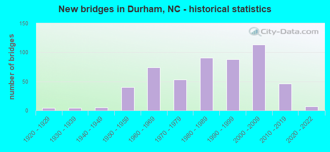
- New bridges - historical statistics
- 41920-1929
- 41930-1939
- 51940-1949
- 401950-1959
- 741960-1969
- 531970-1979
- 911980-1989
- 881990-1999
- 1132000-2009
- 462010-2019
- 72020-2022
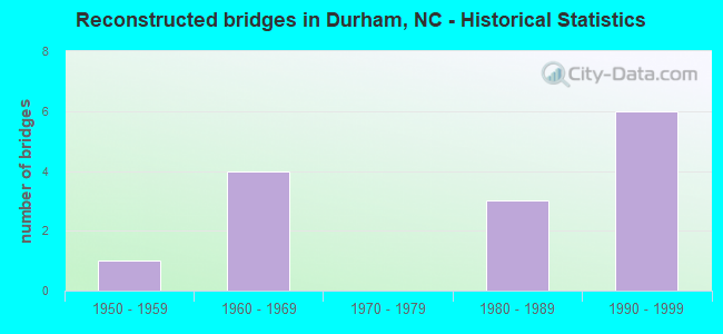
- Reconstructed bridges - Historical Statistics
- 11950-1959
- 41960-1969
- 01970-1979
- 31980-1989
- 61990-1999
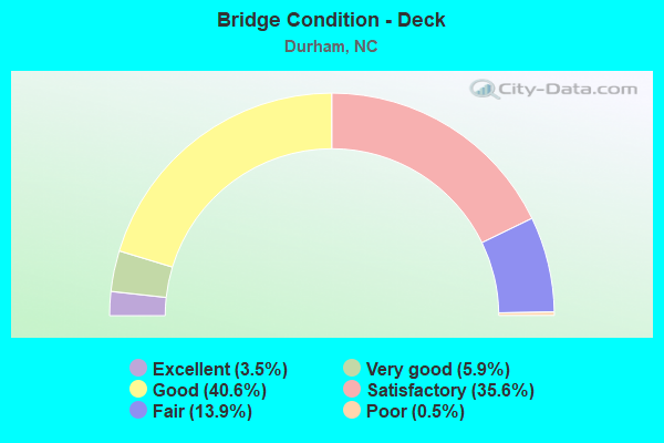
- Bridge Condition - Deck
- 3.5%Excellent
- 5.9%Very good
- 40.6%Good
- 35.6%Satisfactory
- 13.9%Fair
- 0.5%Poor
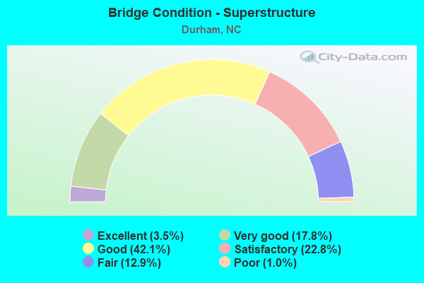
- Bridge Condition - Superstructure
- 3.5%Excellent
- 17.8%Very good
- 42.1%Good
- 22.8%Satisfactory
- 12.9%Fair
- 1.0%Poor
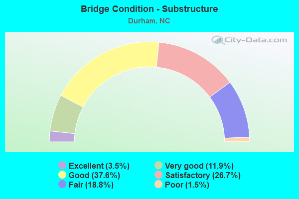
- Bridge Condition - Substructure
- 3.5%Excellent
- 11.9%Very good
- 37.6%Good
- 26.7%Satisfactory
- 18.8%Fair
- 1.5%Poor
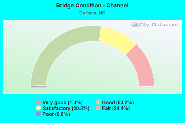
- Bridge Condition - Channel
- 1.3%Very good
- 53.2%Good
- 20.5%Satisfactory
- 24.4%Fair
- 0.6%Poor
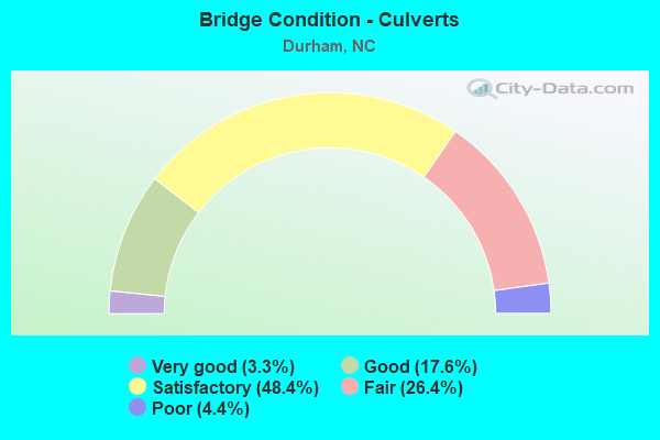
- Bridge Condition - Culverts
- 3.3%Very good
- 17.6%Good
- 48.4%Satisfactory
- 26.4%Fair
- 4.4%Poor
Find on map >> Show street view
Structure Number: 630224, Location: 0.3 MI N JCT NC 54 (Lat: 35.894411, Lng: -78.859997), Route carried "under" structure: Interstate 40, Year Built: 1973, Structure Length: 0. m, Average Daily Traffic: 86,500 (year 2019), Truck Traffic: 16%, Features Intersected: SR1999
Minimum Vertical Clearance: 6.18m (20.28ft), Kilometerpoint: 85.345, Lanes on structure: 6, Lanes under structure: 5, Material/Design: Steel continuous, Design/Construction: Stringer/Multi-beam, Length of Maximum Span: 35.9m (117.8ft)
Find on map >> Show street view
Structure Number: 630224, Location: 0.3 MI N JCT NC 54 (Lat: 35.894411, Lng: -78.859997), Route carried "under" structure: Interstate 40, Year Built: 1973, Structure Length: 0. m, Average Daily Traffic: 86,500 (year 2019), Truck Traffic: 16%, Features Intersected: SR1999
Minimum Vertical Clearance: 5.51m (18.08ft), Kilometerpoint: 85.345, Lanes on structure: 6, Lanes under structure: 5, Material/Design: Steel continuous, Design/Construction: Stringer/Multi-beam, Length of Maximum Span: 35.9m (117.8ft)
Find on map >> Show street view
Structure Number: 630228, Location: 0.3 MI. S. JCT. SR2058 (Lat: 35.890600, Lng: -78.848589), Route carried "under" structure: Interstate 40, Year Built: 1969, Structure Length: 0. m, Average Daily Traffic: 89,500 (year 2019), Truck Traffic: 16%, Features Intersected: SR1959
Minimum Vertical Clearance: 5.60m (18.37ft), Kilometerpoint: 85.649, Lanes on structure: 7, Lanes under structure: 5, Material/Design: Steel continuous, Design/Construction: Stringer/Multi-beam, Length of Maximum Span: 25.6m (84.0ft)
Find on map >> Show street view
Structure Number: 630228, Location: 0.3 MI. S. JCT. SR2058 (Lat: 35.890600, Lng: -78.848589), Route carried "under" structure: Interstate 40, Year Built: 1969, Structure Length: 0. m, Average Daily Traffic: 89,500 (year 2019), Truck Traffic: 16%, Features Intersected: SR1959
Minimum Vertical Clearance: 5.51m (18.08ft), Kilometerpoint: 85.649, Lanes on structure: 7, Lanes under structure: 5, Material/Design: Steel continuous, Design/Construction: Stringer/Multi-beam, Length of Maximum Span: 25.6m (84.0ft)
Find on map >> Show street view
Structure Number: 630246, Location: 0.2 MI.E.JCT.SWIFT AVENUE (Lat: 36.003844, Lng: -78.916786), Route carried "under" structure: City street , Year Built: 1950, Structure Length: 0. m, Average Daily Traffic: 100 (year 1993), Truck Traffic: 7%, Features Intersected: PETTIGREW STREET, Facility Carried by Structure: CAMPUS DRIVE
Minimum Vertical Clearance: 3.44m (11.29ft), Kilometerpoint: 0.000, Lanes on structure: 2, Lanes under structure: 2, Material/Design: Concrete, Design/Construction: Tee Beam, Length of Maximum Span: 8.8m (28.9ft)
Find on map >> Show street view
Structure Number: 63028, Location: .15MI.E.JCT.MANGUM ST. (Lat: 35.993003, Lng: -78.899028), Route carried "under" structure: City street , Year Built: 1981, Structure Length: 0. m, Average Daily Traffic: 11,000 (year 2017), Truck Traffic: 12%, Features Intersected: RAMSEUR STREET, Facility Carried by Structure: S.ROXBOROSTREET
Minimum Vertical Clearance: 3.84m (12.60ft), Kilometerpoint: 0.000, Lanes on structure: 2, Lanes under structure: 2, Material/Design: Steel, Design/Construction: Stringer/Multi-beam, Length of Maximum Span: 20.4m (66.9ft)
Find on map >> Show street view
Structure Number: 630289, Location: 1.1 MI.W.JCT.I40 & NC147 (Lat: 35.906892, Lng: -78.894183), Route carried "under" structure: State highway 55, Year Built: 1985, Structure Length: 0. m, Average Daily Traffic: 17,500 (year 2018), Truck Traffic: 12%, Features Intersected: I40 WBL
Minimum Vertical Clearance: 6.61m (21.69ft), Kilometerpoint: 0.000, Lanes on structure: 4, Lanes under structure: 4, Material/Design: Prestressed concrete, Design/Construction: Stringer/Multi-beam, Length of Maximum Span: 25.9m (85.0ft)
Find on map >> Show street view
Structure Number: 630289, Location: 1.1 MI.W.JCT.I40 & NC147 (Lat: 35.906892, Lng: -78.894183), Route carried "under" structure: State highway 55, Year Built: 1985, Structure Length: 0. m, Average Daily Traffic: 17,500 (year 2018), Truck Traffic: 12%, Features Intersected: I40 WBL
Minimum Vertical Clearance: 6.48m (21.26ft), Kilometerpoint: 0.000, Lanes on structure: 4, Lanes under structure: 2, Material/Design: Prestressed concrete, Design/Construction: Stringer/Multi-beam, Length of Maximum Span: 25.9m (85.0ft)
Find on map >> Show street view
Structure Number: 63029, Location: 1.1 MI.W.JCT.I40 & NC147 (Lat: 35.906736, Lng: -78.894225), Route carried "under" structure: State highway 55, Year Built: 1985, Structure Length: 0. m, Average Daily Traffic: 17,500 (year 2018), Truck Traffic: 12%, Features Intersected: I40E
Minimum Vertical Clearance: 5.61m (18.41ft), Kilometerpoint: 0.000, Lanes on structure: 4, Lanes under structure: 2, Material/Design: Prestressed concrete, Design/Construction: Stringer/Multi-beam, Length of Maximum Span: 24.6m (80.7ft)
Find on map >> Show street view
Structure Number: 63029, Location: 1.1 MI.W.JCT.I40 & NC147 (Lat: 35.906736, Lng: -78.894225), Route carried "under" structure: State highway 55, Year Built: 1985, Structure Length: 0. m, Average Daily Traffic: 17,500 (year 2018), Truck Traffic: 12%, Features Intersected: I40E
Minimum Vertical Clearance: 6.33m (20.77ft), Kilometerpoint: 0.000, Lanes on structure: 4, Lanes under structure: 4, Material/Design: Prestressed concrete, Design/Construction: Stringer/Multi-beam, Length of Maximum Span: 24.6m (80.7ft)
Find on map >> Show street view
Structure Number: 630293, Location: 0.3 MI.E. OF JCT.NC55 (Lat: 35.906175, Lng: -78.888753), Route carried "under" structure: State highway 1945, Year Built: 1985, Structure Length: 0. m, Average Daily Traffic: 9,300 (year 2015), Truck Traffic: 7%, Features Intersected: I40 WBL
Minimum Vertical Clearance: 5.58m (18.31ft), Kilometerpoint: 0.000, Lanes on structure: 3, Lanes under structure: 2, Material/Design: Prestressed concrete, Design/Construction: Stringer/Multi-beam, Length of Maximum Span: 15.5m (50.9ft)
Find on map >> Show street view
Structure Number: 630294, Location: 0.3 MI.E.JCT.NC55 (Lat: 35.906019, Lng: -78.888803), Route carried "under" structure: State highway 1945, Year Built: 1985, Structure Length: 0. m, Average Daily Traffic: 11,500 (year 2019), Truck Traffic: 7%, Features Intersected: I40E
Minimum Vertical Clearance: 4.69m (15.39ft), Kilometerpoint: 0.000, Lanes on structure: 3, Lanes under structure: 2, Material/Design: Prestressed concrete, Design/Construction: Stringer/Multi-beam, Length of Maximum Span: 15.5m (50.9ft)
Find on map >> Show street view
Structure Number: 630295, Location: 0.3 MI.E.JCT.SR2028&I-40 (Lat: 35.900806, Lng: -78.874825), Route carried "under" structure: State highway 147, Year Built: 1985, Structure Length: 0. m, Average Daily Traffic: 37,250 (year 2019), Truck Traffic: 12%, Features Intersected: I40W
Minimum Vertical Clearance: 5.24m (17.19ft), Kilometerpoint: 0.000, Lanes on structure: 5, Lanes under structure: 3, Material/Design: Steel, Design/Construction: Stringer/Multi-beam, Length of Maximum Span: 30.4m (99.7ft)
Find on map >> Show street view
Structure Number: 630295, Location: 0.3 MI.E.JCT.SR2028&I-40 (Lat: 35.900806, Lng: -78.874825), Route carried "under" structure: State highway 147, Year Built: 1985, Structure Length: 0. m, Average Daily Traffic: 37,250 (year 2019), Truck Traffic: 12%, Features Intersected: I40W
Minimum Vertical Clearance: 5.97m (19.59ft), Kilometerpoint: 0.000, Lanes on structure: 5, Lanes under structure: 3, Material/Design: Steel, Design/Construction: Stringer/Multi-beam, Length of Maximum Span: 30.4m (99.7ft)
Find on map >> Show street view
Structure Number: 630296, Location: 0.3 MI.E.JCT.SR2028&I-40 (Lat: 35.900581, Lng: -78.874981), Route carried "under" structure: State highway 147, Year Built: 1985, Structure Length: 0. m, Average Daily Traffic: 32,000 (year 2015), Truck Traffic: 12%, Features Intersected: I40E
Minimum Vertical Clearance: 5.21m (17.09ft), Kilometerpoint: 0.000, Lanes on structure: 4, Lanes under structure: 3, Material/Design: Steel, Design/Construction: Stringer/Multi-beam, Length of Maximum Span: 26.5m (86.9ft)
Find on map >> Show street view
Structure Number: 630296, Location: 0.3 MI.E.JCT.SR2028&I-40 (Lat: 35.900581, Lng: -78.874981), Route carried "under" structure: State highway 147, Year Built: 1985, Structure Length: 0. m, Average Daily Traffic: 32,000 (year 2015), Truck Traffic: 12%, Features Intersected: I40E
Minimum Vertical Clearance: 5.79m (19.00ft), Kilometerpoint: 0.000, Lanes on structure: 4, Lanes under structure: 3, Material/Design: Steel, Design/Construction: Stringer/Multi-beam, Length of Maximum Span: 26.5m (86.9ft)
Find on map >> Show street view
Structure Number: 630297, Location: 0.5 MI.E.JCT.SR2028 (Lat: 35.899714, Lng: -78.871047), Route carried "under" structure: Ramp Interstate 40, Year Built: 1985, Structure Length: 0. m, Average Daily Traffic: 36,000 (year 2017), Truck Traffic: 16%, Features Intersected: I40W
Minimum Vertical Clearance: 5.28m (17.32ft), Kilometerpoint: 0.000, Lanes on structure: 3, Lanes under structure: 1, Material/Design: Steel, Design/Construction: Stringer/Multi-beam, Length of Maximum Span: 27.7m (90.9ft)
Find on map >> Show street view
Structure Number: 6303, Location: 0.14 MI. E. JCT. SR2028 (Lat: 35.897553, Lng: -78.876206), Route carried "under" structure: State highway 147, Year Built: 2011, Structure Length: 0. m, Average Daily Traffic: 3,800 (year 2013), Truck Traffic: 12%, Features Intersected: NC54
Minimum Vertical Clearance: 7.13m (23.39ft), Kilometerpoint: 0.000, Lanes on structure: 5, Lanes under structure: 4, Material/Design: Prestressed concrete continuous, Design/Construction: Stringer/Multi-beam, Length of Maximum Span: 34.7m (113.8ft)
Find on map >> Show street view
Structure Number: 6303, Location: 0.14 MI. E. JCT. SR2028 (Lat: 35.897553, Lng: -78.876206), Route carried "under" structure: Ramp State highway 147, Year Built: 2011, Structure Length: 0. m, Average Daily Traffic: 5,300 (year 2019), Truck Traffic: 16%, Features Intersected: NC54
Minimum Vertical Clearance: 8.86m (29.07ft), Kilometerpoint: 0.000, Lanes on structure: 5, Lanes under structure: 1, Material/Design: Prestressed concrete continuous, Design/Construction: Stringer/Multi-beam, Length of Maximum Span: 34.7m (113.8ft)
Find on map >> Show street view
Structure Number: 6303, Location: 0.14 MI. E. JCT. SR2028 (Lat: 35.897553, Lng: -78.876206), Route carried "under" structure: State highway 147, Year Built: 2011, Structure Length: 0. m, Average Daily Traffic: 3,800 (year 2013), Truck Traffic: 12%, Features Intersected: NC54
Minimum Vertical Clearance: 7.68m (25.20ft), Kilometerpoint: 0.000, Lanes on structure: 5, Lanes under structure: 2, Material/Design: Prestressed concrete continuous, Design/Construction: Stringer/Multi-beam, Length of Maximum Span: 34.7m (113.8ft)
Find on map >> Show street view
Structure Number: 630301, Location: @ JCT.US15/501 & I40 (Lat: 35.950867, Lng: -78.998964), Route carried "under" structure: Interstate 40, Year Built: 1986, Structure Length: 0. m, Average Daily Traffic: 40,500 (year 2018), Truck Traffic: 16%, Features Intersected: US15,US501
Minimum Vertical Clearance: 5.53m (18.14ft), Kilometerpoint: 82.297, Lanes on structure: 10, Lanes under structure: 3, Material/Design: Steel, Design/Construction: Stringer/Multi-beam, Length of Maximum Span: 31.0m (101.7ft)
Find on map >> Show street view
Structure Number: 630301, Location: @ JCT.US15/501 & I40 (Lat: 35.950867, Lng: -78.998964), Route carried "under" structure: Interstate 40, Year Built: 1986, Structure Length: 0. m, Average Daily Traffic: 40,500 (year 2018), Truck Traffic: 16%, Features Intersected: US15,US501
Minimum Vertical Clearance: 5.21m (17.09ft), Kilometerpoint: 82.297, Lanes on structure: 10, Lanes under structure: 3, Material/Design: Steel, Design/Construction: Stringer/Multi-beam, Length of Maximum Span: 31.0m (101.7ft)
Find on map >> Show street view
Structure Number: 630302, Location: 0.01 MI. W. JCT. SR1113 (Lat: 35.945128, Lng: -78.994503), Route carried "under" structure: Interstate 40, Year Built: 1986, Structure Length: 0. m, Average Daily Traffic: 49,500 (year 2019), Truck Traffic: 16%, Features Intersected: SR2220
Minimum Vertical Clearance: 5.27m (17.29ft), Kilometerpoint: 82.449, Lanes on structure: 2, Lanes under structure: 3, Material/Design: Steel, Design/Construction: Stringer/Multi-beam, Length of Maximum Span: 42.6m (139.8ft)
Find on map >> Show street view
Structure Number: 630302, Location: 0.01 MI. W. JCT. SR1113 (Lat: 35.945128, Lng: -78.994503), Route carried "under" structure: Interstate 40, Year Built: 1986, Structure Length: 0. m, Average Daily Traffic: 49,500 (year 2019), Truck Traffic: 16%, Features Intersected: SR2220
Minimum Vertical Clearance: 5.02m (16.47ft), Kilometerpoint: 82.449, Lanes on structure: 2, Lanes under structure: 3, Material/Design: Steel, Design/Construction: Stringer/Multi-beam, Length of Maximum Span: 42.6m (139.8ft)
Find on map >> Show street view
Structure Number: 630305, Location: 1.1 MI.S.JCT.NC54 (Lat: 35.903961, Lng: -78.960025), Route carried "under" structure: Interstate 40, Year Built: 1986, Structure Length: 0. m, Average Daily Traffic: 61,000 (year 2019), Truck Traffic: 16%, Features Intersected: NC751
Minimum Vertical Clearance: 5.27m (17.29ft), Kilometerpoint: 83.577, Lanes on structure: 6, Lanes under structure: 3, Material/Design: Steel, Design/Construction: Stringer/Multi-beam, Length of Maximum Span: 29.8m (97.8ft)
Find on map >> Show street view
Structure Number: 630306, Location: 1.0 MI.E.JCT.NC751 (Lat: 35.908742, Lng: -78.935742), Route carried "under" structure: Interstate 40, Year Built: 2001, Structure Length: 0. m, Average Daily Traffic: 61,000 (year 2019), Truck Traffic: 16%, Features Intersected: SR1118
Minimum Vertical Clearance: 5.91m (19.39ft), Kilometerpoint: 83.973, Lanes on structure: 7, Lanes under structure: 3, Material/Design: Steel, Design/Construction: Stringer/Multi-beam, Length of Maximum Span: 30.1m (98.8ft)
Find on map >> Show street view
Structure Number: 630306, Location: 1.0 MI.E.JCT.NC751 (Lat: 35.908742, Lng: -78.935742), Route carried "under" structure: Interstate 40, Year Built: 2001, Structure Length: 0. m, Average Daily Traffic: 61,000 (year 2019), Truck Traffic: 16%, Features Intersected: SR1118
Minimum Vertical Clearance: 5.82m (19.09ft), Kilometerpoint: 83.973, Lanes on structure: 7, Lanes under structure: 3, Material/Design: Steel, Design/Construction: Stringer/Multi-beam, Length of Maximum Span: 30.1m (98.8ft)
Find on map >> Show street view
Structure Number: 630307, Location: 0.2 MI.E.JCT.SR1118 (Lat: 35.909483, Lng: -78.930367), Route carried "under" structure: State highway 5, Year Built: 1986, Structure Length: 0. m, Average Daily Traffic: 9,250 (year 2019), Truck Traffic: 12%, Features Intersected: I40W
Minimum Vertical Clearance: 5.24m (17.19ft), Kilometerpoint: 0.000, Lanes on structure: 3, Lanes under structure: 1, Material/Design: Steel, Design/Construction: Stringer/Multi-beam, Length of Maximum Span: 47.2m (154.9ft)
Find on map >> Show street view
Structure Number: 630308, Location: 0.2 MI.E.JCT.SR1118 (Lat: 35.909356, Lng: -78.929967), Route carried "under" structure: State highway 54, Year Built: 1986, Structure Length: 0. m, Average Daily Traffic: 9,250 (year 2019), Truck Traffic: 12%, Features Intersected: I40E
Minimum Vertical Clearance: 5.05m (16.57ft), Kilometerpoint: 0.000, Lanes on structure: 4, Lanes under structure: 1, Material/Design: Steel, Design/Construction: Stringer/Multi-beam, Length of Maximum Span: 48.1m (157.8ft)
Find on map >> Show street view
Structure Number: 630309, Location: 0.3 MI.N.JCT.NC54 (Lat: 35.908778, Lng: -78.916419), Route carried "under" structure: Interstate 40, Year Built: 1985, Structure Length: 0. m, Average Daily Traffic: 62,000 (year 2015), Truck Traffic: 16%, Features Intersected: SR1106
Minimum Vertical Clearance: 5.02m (16.47ft), Kilometerpoint: 84.430, Lanes on structure: 2, Lanes under structure: 3, Material/Design: Steel, Design/Construction: Stringer/Multi-beam, Length of Maximum Span: 28.6m (93.8ft)
Find on map >> Show street view
Structure Number: 630309, Location: 0.3 MI.N.JCT.NC54 (Lat: 35.908778, Lng: -78.916419), Route carried "under" structure: Interstate 40, Year Built: 1985, Structure Length: 0. m, Average Daily Traffic: 6,200 (year 2015), Truck Traffic: 16%, Features Intersected: SR1106
Minimum Vertical Clearance: 5.42m (17.78ft), Kilometerpoint: 84.430, Lanes on structure: 2, Lanes under structure: 3, Material/Design: Steel, Design/Construction: Stringer/Multi-beam, Length of Maximum Span: 28.6m (93.8ft)
Find on map >> Show street view
Structure Number: 630311, Location: 0.2 MI.S.JCT.US70 BUS. (Lat: 36.016064, Lng: -78.945928), Route carried "under" structure: State highway 147, Year Built: 1985, Structure Length: 0. m, Average Daily Traffic: 22,500 (year 2019), Truck Traffic: 12%, Features Intersected: LASALLE ST.
Minimum Vertical Clearance: 5.51m (18.08ft), Kilometerpoint: 4.876, Lanes on structure: 3, Lanes under structure: 4, Material/Design: Steel, Design/Construction: Stringer/Multi-beam, Length of Maximum Span: 29.5m (96.8ft)
Find on map >> Show street view
Structure Number: 630311, Location: 0.2 MI.S.JCT.US70 BUS. (Lat: 36.016064, Lng: -78.945928), Route carried "under" structure: State highway 147, Year Built: 1985, Structure Length: 0. m, Average Daily Traffic: 22,500 (year 2019), Truck Traffic: 12%, Features Intersected: LASALLE ST.
Minimum Vertical Clearance: 5.18m (16.99ft), Kilometerpoint: 4.876, Lanes on structure: 3, Lanes under structure: 4, Material/Design: Steel, Design/Construction: Stringer/Multi-beam, Length of Maximum Span: 29.5m (96.8ft)
Find on map >> Show street view
Structure Number: 630312, Location: 0.2 MI. S. JCT. US70 BUS. (Lat: 36.007222, Lng: -78.929597), Route carried "under" structure: State highway 147, Year Built: 1986, Structure Length: 0. m, Average Daily Traffic: 31,000 (year 2018), Truck Traffic: 12%, Features Intersected: ANDERSON STREET
Minimum Vertical Clearance: 5.54m (18.18ft), Kilometerpoint: 0.000, Lanes on structure: 4, Lanes under structure: 3, Material/Design: Steel, Design/Construction: Stringer/Multi-beam, Length of Maximum Span: 28.6m (93.8ft)
Find on map >> Show street view
Structure Number: 630312, Location: 0.2 MI. S. JCT. US70 BUS. (Lat: 36.007222, Lng: -78.929597), Route carried "under" structure: Ramp State highway 147, Year Built: 1986, Structure Length: 0. m, Average Daily Traffic: 7,500 (year 2018), Truck Traffic: 12%, Features Intersected: ANDERSON STREET
Minimum Vertical Clearance: 7.46m (24.48ft), Kilometerpoint: 0.000, Lanes on structure: 4, Lanes under structure: 1, Material/Design: Steel, Design/Construction: Stringer/Multi-beam, Length of Maximum Span: 28.6m (93.8ft)
Find on map >> Show street view
Structure Number: 630312, Location: 0.2 MI. S. JCT. US70 BUS. (Lat: 36.007222, Lng: -78.929597), Route carried "under" structure: State highway 147, Year Built: 1986, Structure Length: 0. m, Average Daily Traffic: 31,000 (year 2018), Truck Traffic: 12%, Features Intersected: ANDERSON STREET
Minimum Vertical Clearance: 6.88m (22.57ft), Kilometerpoint: 0.000, Lanes on structure: 4, Lanes under structure: 2, Material/Design: Steel, Design/Construction: Stringer/Multi-beam, Length of Maximum Span: 28.6m (93.8ft)
Find on map >> Show street view
Structure Number: 630313, Location: 0.3 MI.N.JCT.SR1113 (Lat: 35.933128, Lng: -78.989094), Route carried "under" structure: Interstate 40, Year Built: 1987, Structure Length: 0. m, Average Daily Traffic: 49,500 (year 2019), Truck Traffic: 16%, Features Intersected: SR1110
Minimum Vertical Clearance: 5.05m (16.57ft), Kilometerpoint: 82.693, Lanes on structure: 2, Lanes under structure: 3, Material/Design: Steel, Design/Construction: Stringer/Multi-beam, Length of Maximum Span: 35.0m (114.8ft)
Find on map >> Show street view
Structure Number: 630313, Location: 0.3 MI.N.JCT.SR1113 (Lat: 35.933128, Lng: -78.989094), Route carried "under" structure: Interstate 40, Year Built: 1987, Structure Length: 0. m, Average Daily Traffic: 49,500 (year 2019), Truck Traffic: 16%, Features Intersected: SR1110
Minimum Vertical Clearance: 5.27m (17.29ft), Kilometerpoint: 82.693, Lanes on structure: 2, Lanes under structure: 3, Material/Design: Steel, Design/Construction: Stringer/Multi-beam, Length of Maximum Span: 35.0m (114.8ft)
Find on map >> Show street view
Structure Number: 630314, Location: 0.1 MI. W. JCT. SR1110 (Lat: 35.913036, Lng: -78.982064), Route carried "under" structure: Interstate 40, Year Built: 1987, Structure Length: 0. m, Average Daily Traffic: 59,000 (year 2018), Truck Traffic: 16%, Features Intersected: NC54
Minimum Vertical Clearance: 5.02m (16.47ft), Kilometerpoint: 83.119, Lanes on structure: 5, Lanes under structure: 4, Material/Design: Steel, Design/Construction: Stringer/Multi-beam, Length of Maximum Span: 31.0m (101.7ft)
Find on map >> Show street view
Structure Number: 630314, Location: 0.1 MI. W. JCT. SR1110 (Lat: 35.913036, Lng: -78.982064), Route carried "under" structure: Interstate 40, Year Built: 1987, Structure Length: 0. m, Average Daily Traffic: 59,000 (year 2018), Truck Traffic: 16%, Features Intersected: NC54
Minimum Vertical Clearance: 5.36m (17.59ft), Kilometerpoint: 83.119, Lanes on structure: 5, Lanes under structure: 3, Material/Design: Steel, Design/Construction: Stringer/Multi-beam, Length of Maximum Span: 31.0m (101.7ft)
Find on map >> Show street view
Structure Number: 630316, Location: 0.2 MI.E.JCT.SR1322 (Lat: 36.004278, Lng: -78.916417), Route carried "under" structure: City street , Year Built: 2013, Structure Length: 0. m, Average Daily Traffic: 3,400 (year 2000), Truck Traffic: 7%, Features Intersected: US70BUS, Facility Carried by Structure: CAMPUS DRIVE
Minimum Vertical Clearance: 4.11m (13.48ft), Kilometerpoint: 0.000, Lanes on structure: 2, Lanes under structure: 2, Material/Design: Steel, Design/Construction: Stringer/Multi-beam, Length of Maximum Span: 23.4m (76.8ft)
Find on map >> Show street view
Structure Number: 630317, Location: 0.8 MI. S. JCT. US15/501 (Lat: 36.013475, Lng: -78.936403), Route carried "under" structure: Ramp State highway 147, Year Built: 1988, Structure Length: 0. m, Average Daily Traffic: 10,750 (year 2018), Truck Traffic: 12%, Features Intersected: NC147S
Minimum Vertical Clearance: 4.69m (15.39ft), Kilometerpoint: 0.000, Lanes on structure: 2, Lanes under structure: 2, Material/Design: Steel, Design/Construction: Stringer/Multi-beam, Length of Maximum Span: 62.1m (203.7ft)
Find on map >> Show street view
Structure Number: 630317, Location: 0.8 MI. S. JCT. US15/501 (Lat: 36.013475, Lng: -78.936403), Route carried "under" structure: State highway 1321, Year Built: 1988, Structure Length: 0. m, Average Daily Traffic: 20,000 (year 2018), Truck Traffic: 6%, Features Intersected: NC147S
Minimum Vertical Clearance: 4.81m (15.78ft), Kilometerpoint: 0.000, Lanes on structure: 2, Lanes under structure: 6, Material/Design: Steel, Design/Construction: Stringer/Multi-beam, Length of Maximum Span: 62.1m (203.7ft)
Find on map >> Show street view
Structure Number: 630317, Location: 0.8 MI. S. JCT. US15/501 (Lat: 36.013475, Lng: -78.936403), Route carried "under" structure: Ramp State highway 1321, Year Built: 1988, Structure Length: 0. m, Average Daily Traffic: 10,750 (year 2018), Truck Traffic: 12%, Features Intersected: NC147S, Facility Carried by Structure: NC147N,RAMP
Minimum Vertical Clearance: 5.05m (16.57ft), Kilometerpoint: 0.000, Lanes on structure: 2, Lanes under structure: 1, Material/Design: Steel, Design/Construction: Stringer/Multi-beam, Length of Maximum Span: 62.1m (203.7ft)
Find on map >> Show street view
Structure Number: 630318, Location: 0.8 MI. S. JCT. US15/501 (Lat: 36.013647, Lng: -78.936328), Route carried "under" structure: Ramp State highway 147, Year Built: 1988, Structure Length: 0. m, Average Daily Traffic: 10,750 (year 2015), Truck Traffic: 12%, Features Intersected: NC147N
Minimum Vertical Clearance: 6.21m (20.37ft), Kilometerpoint: 0.000, Lanes on structure: 2, Lanes under structure: 1, Material/Design: Steel, Design/Construction: Stringer/Multi-beam, Length of Maximum Span: 63.7m (209.0ft)
Find on map >> Show street view
Structure Number: 630318, Location: 0.8 MI. S. JCT. US15/501 (Lat: 36.013647, Lng: -78.936328), Route carried "under" structure: Ramp State highway 147, Year Built: 1988, Structure Length: 0. m, Average Daily Traffic: 10,750 (year 2015), Truck Traffic: 12%, Features Intersected: NC147N
Minimum Vertical Clearance: 6.12m (20.08ft), Kilometerpoint: 0.000, Lanes on structure: 2, Lanes under structure: 2, Material/Design: Steel, Design/Construction: Stringer/Multi-beam, Length of Maximum Span: 63.7m (209.0ft)
Find on map >> Show street view
Structure Number: 630318, Location: 0.8 MI. S. JCT. US15/501 (Lat: 36.013647, Lng: -78.936328), Route carried "under" structure: State highway 1321, Year Built: 1988, Structure Length: 0. m, Average Daily Traffic: 10,750 (year 2015), Truck Traffic: 12%, Features Intersected: NC147N
Minimum Vertical Clearance: 6.06m (19.88ft), Kilometerpoint: 0.000, Lanes on structure: 2, Lanes under structure: 2, Material/Design: Steel, Design/Construction: Stringer/Multi-beam, Length of Maximum Span: 63.7m (209.0ft)
Find on map >> Show street view
Structure Number: 630322, Location: 0.5 MI.S.LASALLE STREET (Lat: 36.009164, Lng: -78.932156), Route carried "under" structure: State highway 147, Year Built: 1990, Structure Length: 0. m, Average Daily Traffic: 23,750 (year 2019), Truck Traffic: 12%, Features Intersected: NC147 RAMP
Minimum Vertical Clearance: 6.40m (21.00ft), Kilometerpoint: 0.000, Lanes on structure: 2, Lanes under structure: 2, Material/Design: Steel, Design/Construction: Stringer/Multi-beam, Length of Maximum Span: 27.1m (88.9ft)
Find on map >> Show street view
Structure Number: 630322, Location: 0.5 MI.S.LASALLE STREET (Lat: 36.009164, Lng: -78.932156), Route carried "under" structure: State highway 147, Year Built: 1990, Structure Length: 0. m, Average Daily Traffic: 23,750 (year 2019), Truck Traffic: 12%, Features Intersected: NC147 RAMP
Minimum Vertical Clearance: 5.54m (18.18ft), Kilometerpoint: 0.000, Lanes on structure: 2, Lanes under structure: 3, Material/Design: Steel, Design/Construction: Stringer/Multi-beam, Length of Maximum Span: 27.1m (88.9ft)
Find on map >> Show street view
Structure Number: 630326, Location: 0.79 MI.E.JCT.US15-501BYP (Lat: 36.015658, Lng: -78.936089), Route carried "under" structure: State highway 1321, Year Built: 1991, Structure Length: 0. m, Average Daily Traffic: 10,500 (year 2019), Truck Traffic: 6%, Features Intersected: US70BUS.
Minimum Vertical Clearance: 4.82m (15.81ft), Kilometerpoint: 0.000, Lanes on structure: 5, Lanes under structure: 2, Material/Design: Steel continuous, Design/Construction: Stringer/Multi-beam, Length of Maximum Span: 35.3m (115.8ft)
Find on map >> Show street view
Structure Number: 630326, Location: 0.79 MI.E.JCT.US15-501BYP (Lat: 36.015658, Lng: -78.936089), Route carried "under" structure: State highway 1321, Year Built: 1991, Structure Length: 0. m, Average Daily Traffic: 10,500 (year 2019), Truck Traffic: 6%, Features Intersected: US70BUS.
Minimum Vertical Clearance: 5.10m (16.73ft), Kilometerpoint: 0.000, Lanes on structure: 5, Lanes under structure: 4, Material/Design: Steel continuous, Design/Construction: Stringer/Multi-beam, Length of Maximum Span: 35.3m (115.8ft)
Find on map >> Show street view
Structure Number: 630327, Location: 0.3MI.W.JCT.SR1322 (Lat: 36.005372, Lng: -78.923411), Route carried "under" structure: State highway 1320, Year Built: 1991, Structure Length: 0. m, Average Daily Traffic: 7,400 (year 2019), Truck Traffic: 6%, Features Intersected: NC147NB
Minimum Vertical Clearance: 6.55m (21.49ft), Kilometerpoint: 0.000, Lanes on structure: 3, Lanes under structure: 3, Material/Design: Steel, Design/Construction: Stringer/Multi-beam, Length of Maximum Span: 29.2m (95.8ft)
Find on map >> Show street view
Structure Number: 630328, Location: 0.4 MI. S. JCT. US70 BUS. (Lat: 36.016583, Lng: -78.951111), Route carried "under" structure: US 15, Year Built: 1991, Structure Length: 0. m, Average Daily Traffic: 21,000 (year 2019), Truck Traffic: 12%, Features Intersected: NC147S
Minimum Vertical Clearance: 7.55m (24.77ft), Kilometerpoint: 0.000, Lanes on structure: 4, Lanes under structure: 2, Material/Design: Steel, Design/Construction: Stringer/Multi-beam, Length of Maximum Span: 27.1m (88.9ft)
Find on map >> Show street view
Structure Number: 630328, Location: 0.4 MI. S. JCT. US70 BUS. (Lat: 36.016583, Lng: -78.951111), Route carried "under" structure: Ramp US 15, Year Built: 1991, Structure Length: 0. m, Average Daily Traffic: 10,500 (year 2019), Truck Traffic: 12%, Features Intersected: NC147S
Minimum Vertical Clearance: 8.62m (28.28ft), Kilometerpoint: 0.000, Lanes on structure: 4, Lanes under structure: 3, Material/Design: Steel, Design/Construction: Stringer/Multi-beam, Length of Maximum Span: 27.1m (88.9ft)
Find on map >> Show street view
Structure Number: 630328, Location: 0.4 MI. S. JCT. US70 BUS. (Lat: 36.016583, Lng: -78.951111), Route carried "under" structure: US 15, Year Built: 1991, Structure Length: 0. m, Average Daily Traffic: 21,000 (year 2019), Truck Traffic: 12%, Features Intersected: NC147S
Minimum Vertical Clearance: 8.13m (26.67ft), Kilometerpoint: 0.000, Lanes on structure: 4, Lanes under structure: 2, Material/Design: Steel, Design/Construction: Stringer/Multi-beam, Length of Maximum Span: 27.1m (88.9ft)
Find on map >> Show street view
Structure Number: 630328, Location: 0.4 MI. S. JCT. US70 BUS. (Lat: 36.016583, Lng: -78.951111), Route carried "under" structure: Ramp US 15, Year Built: 1991, Structure Length: 0. m, Average Daily Traffic: 10,500 (year 2019), Truck Traffic: 12%, Features Intersected: NC147S
Minimum Vertical Clearance: 6.98m (22.90ft), Kilometerpoint: 0.000, Lanes on structure: 4, Lanes under structure: 2, Material/Design: Steel, Design/Construction: Stringer/Multi-beam, Length of Maximum Span: 27.1m (88.9ft)
Find on map >> Show street view
Structure Number: 630336, Location: 0.3 MI. S. JCT. SR1322 (Lat: 36.005325, Lng: -78.923722), Route carried "under" structure: State highway 1320, Year Built: 1991, Structure Length: 0. m, Average Daily Traffic: 8,000 (year 2017), Truck Traffic: 6%, Features Intersected: NC147
Minimum Vertical Clearance: 4.75m (15.58ft), Kilometerpoint: 0.000, Lanes on structure: 3, Lanes under structure: 3, Material/Design: Steel, Design/Construction: Stringer/Multi-beam, Length of Maximum Span: 38.4m (126.0ft)
Find on map >> Show street view
Structure Number: 630338, Location: JCT.NC147&US15/501 BYPASS (Lat: 36.016778, Lng: -78.950917), Route carried "under" structure: Bypass US 15, Year Built: 1994, Structure Length: 0. m, Average Daily Traffic: 21,000 (year 2019), Truck Traffic: 12%, Features Intersected: NC147N
Minimum Vertical Clearance: 6.27m (20.57ft), Kilometerpoint: 32.918, Lanes on structure: 4, Lanes under structure: 2, Material/Design: Steel, Design/Construction: Stringer/Multi-beam, Length of Maximum Span: 25.6m (84.0ft)
Find on map >> Show street view
Structure Number: 630338, Location: JCT.NC147&US15/501 BYPASS (Lat: 36.016778, Lng: -78.950917), Route carried "under" structure: Ramp US 15, Year Built: 1994, Structure Length: 0. m, Average Daily Traffic: 10,500 (year 2019), Truck Traffic: 12%, Features Intersected: NC147N
Minimum Vertical Clearance: 7.28m (23.88ft), Kilometerpoint: 32.918, Lanes on structure: 4, Lanes under structure: 3, Material/Design: Steel, Design/Construction: Stringer/Multi-beam, Length of Maximum Span: 25.6m (84.0ft)
Find on map >> Show street view
Structure Number: 630338, Location: JCT.NC147&US15/501 BYPASS (Lat: 36.016778, Lng: -78.950917), Route carried "under" structure: Ramp US 15, Year Built: 1994, Structure Length: 0. m, Average Daily Traffic: 10,500 (year 2019), Truck Traffic: 12%, Features Intersected: NC147N
Minimum Vertical Clearance: 5.73m (18.80ft), Kilometerpoint: 32.918, Lanes on structure: 4, Lanes under structure: 2, Material/Design: Steel, Design/Construction: Stringer/Multi-beam, Length of Maximum Span: 25.6m (84.0ft)
Find on map >> Show street view
Structure Number: 630338, Location: JCT.NC147&US15/501 BYPASS (Lat: 36.016778, Lng: -78.950917), Route carried "under" structure: Bypass US 15, Year Built: 1994, Structure Length: 0. m, Average Daily Traffic: 21,000 (year 2019), Truck Traffic: 12%, Features Intersected: NC147N
Minimum Vertical Clearance: 6.84m (22.44ft), Kilometerpoint: 32.918, Lanes on structure: 4, Lanes under structure: 2, Material/Design: Steel, Design/Construction: Stringer/Multi-beam, Length of Maximum Span: 25.6m (84.0ft)
Find on map >> Show street view
Structure Number: 63034, Location: 0.8 MI.W.JCT.SR1959 (Lat: 35.881797, Lng: -78.839506), Route carried "under" structure: State highway 1973, Year Built: 1995, Structure Length: 0. m, Average Daily Traffic: 8,000 (year 2017), Truck Traffic: 7%, Features Intersected: I40
Minimum Vertical Clearance: 5.09m (16.70ft), Kilometerpoint: 0.000, Lanes on structure: 9, Lanes under structure: 4, Material/Design: Steel, Design/Construction: Stringer/Multi-beam, Length of Maximum Span: 30.7m (100.7ft)
Find on map >> Show street view
Structure Number: 63034, Location: 0.8 MI.W.JCT.SR1959 (Lat: 35.881797, Lng: -78.839506), Route carried "under" structure: State highway 1973, Year Built: 1995, Structure Length: 0. m, Average Daily Traffic: 8,000 (year 2017), Truck Traffic: 7%, Features Intersected: I40
Minimum Vertical Clearance: 5.09m (16.70ft), Kilometerpoint: 0.000, Lanes on structure: 9, Lanes under structure: 2, Material/Design: Steel, Design/Construction: Stringer/Multi-beam, Length of Maximum Span: 30.7m (100.7ft)
Find on map >> Show street view
Structure Number: 630341, Location: .96 MI.E.SR1973 (Lat: 35.873042, Lng: -78.831178), Route carried "under" structure: Interstate 40, Year Built: 1995, Structure Length: 0. m, Average Daily Traffic: 96,500 (year 2018), Truck Traffic: 16%, Features Intersected: I540
Minimum Vertical Clearance: 5.39m (17.68ft), Kilometerpoint: 0.000, Lanes on structure: 2, Lanes under structure: 6, Material/Design: Steel continuous, Design/Construction: Stringer/Multi-beam, Length of Maximum Span: 41.1m (134.8ft)
Find on map >> Show street view
Structure Number: 630341, Location: .96 MI.E.SR1973 (Lat: 35.873042, Lng: -78.831178), Route carried "under" structure: Interstate 40, Year Built: 1995, Structure Length: 0. m, Average Daily Traffic: 88,250 (year 2019), Truck Traffic: 16%, Features Intersected: I540
Minimum Vertical Clearance: 5.39m (17.68ft), Kilometerpoint: 0.000, Lanes on structure: 2, Lanes under structure: 5, Material/Design: Steel continuous, Design/Construction: Stringer/Multi-beam, Length of Maximum Span: 41.1m (134.8ft)
Find on map >> Show street view
Structure Number: 630341, Location: .96 MI.E.SR1973 (Lat: 35.873042, Lng: -78.831178), Route carried "under" structure: Interstate 40, Year Built: 1995, Structure Length: 0. m, Average Daily Traffic: 44,125 (year 2019), Truck Traffic: 16%, Features Intersected: I540
Minimum Vertical Clearance: 5.24m (17.19ft), Kilometerpoint: 0.000, Lanes on structure: 2, Lanes under structure: 2, Material/Design: Steel continuous, Design/Construction: Stringer/Multi-beam, Length of Maximum Span: 41.1m (134.8ft)
Find on map >> Show street view
Structure Number: 630342, Location: 0.96 MI. E. JCT. SR1973 (Lat: 35.873533, Lng: -78.831681), Route carried "under" structure: Interstate 40, Year Built: 1995, Structure Length: 0. m, Average Daily Traffic: 75,500 (year 2015), Truck Traffic: 16%, Features Intersected: I540RAMP
Minimum Vertical Clearance: 10.51m (34.48ft), Kilometerpoint: 86.259, Lanes on structure: 2, Lanes under structure: 4, Material/Design: Steel continuous, Design/Construction: Stringer/Multi-beam, Length of Maximum Span: 57.6m (189.0ft)
Find on map >> Show street view
Structure Number: 630342, Location: 0.96 MI. E. JCT. SR1973 (Lat: 35.873533, Lng: -78.831681), Route carried "under" structure: Interstate 40, Year Built: 1995, Structure Length: 0. m, Average Daily Traffic: 75,500 (year 2015), Truck Traffic: 16%, Features Intersected: I540RAMP
Minimum Vertical Clearance: 11.85m (38.88ft), Kilometerpoint: 86.259, Lanes on structure: 2, Lanes under structure: 6, Material/Design: Steel continuous, Design/Construction: Stringer/Multi-beam, Length of Maximum Span: 57.6m (189.0ft)
Find on map >> Show street view
Structure Number: 630342, Location: 0.96 MI. E. JCT. SR1973 (Lat: 35.873533, Lng: -78.831681), Route carried "under" structure: Ramp Interstate 54, Year Built: 1995, Structure Length: 0. m, Average Daily Traffic: 20,000 (year 2015), Truck Traffic: 7%, Features Intersected: I540RAMP
Minimum Vertical Clearance: 5.39m (17.68ft), Kilometerpoint: 86.259, Lanes on structure: 2, Lanes under structure: 2, Material/Design: Steel continuous, Design/Construction: Stringer/Multi-beam, Length of Maximum Span: 57.6m (189.0ft)
Find on map >> Show street view
Structure Number: 630342, Location: 0.96 MI. E. JCT. SR1973 (Lat: 35.873533, Lng: -78.831681), Route carried "under" structure: Interstate 540, Year Built: 1995, Structure Length: 0. m, Average Daily Traffic: 21,750 (year 2015), Truck Traffic: 16%, Features Intersected: I540RAMP
Minimum Vertical Clearance: 5.63m (18.47ft), Kilometerpoint: 86.259, Lanes on structure: 2, Lanes under structure: 3, Material/Design: Steel continuous, Design/Construction: Stringer/Multi-beam, Length of Maximum Span: 57.6m (189.0ft)
Find on map >> Show street view
Structure Number: 630342, Location: 0.96 MI. E. JCT. SR1973 (Lat: 35.873533, Lng: -78.831681), Route carried "under" structure: Interstate 540, Year Built: 1995, Structure Length: 0. m, Average Daily Traffic: 21,750 (year 2015), Truck Traffic: 16%, Features Intersected: I540RAMP
Minimum Vertical Clearance: 5.42m (17.78ft), Kilometerpoint: 86.259, Lanes on structure: 2, Lanes under structure: 3, Material/Design: Steel continuous, Design/Construction: Stringer/Multi-beam, Length of Maximum Span: 57.6m (189.0ft)
Find on map >> Show street view
Structure Number: 630355, Location: 0.4MI.S.JCT.US70 (Lat: 36.033539, Lng: -78.966639), Route carried "under" structure: Business US 70, Year Built: 1997, Structure Length: 0. m, Average Daily Traffic: 9,100 (year 2019), Truck Traffic: 6%, Features Intersected: NC147S RAMP
Minimum Vertical Clearance: 5.66m (18.57ft), Kilometerpoint: 0.000, Lanes on structure: 2, Lanes under structure: 2, Material/Design: Steel, Design/Construction: Stringer/Multi-beam, Length of Maximum Span: 35.9m (117.8ft)
Find on map >> Show street view
Structure Number: 630422, Location: JCT.I-85,US70 (Lat: 36.012750, Lng: -78.870178), Route carried "under" structure: Ramp US 70, Year Built: 2006, Structure Length: 0. m, Average Daily Traffic: 50,000 (year 2019), Truck Traffic: 12%, Features Intersected: I85S,US70E RAMP
Minimum Vertical Clearance: 5.79m (19.00ft), Kilometerpoint: 86.869, Lanes on structure: 2, Lanes under structure: 2, Material/Design: Steel continuous, Design/Construction: Stringer/Multi-beam, Length of Maximum Span: 58.8m (192.9ft)
Find on map >> Show street view
Structure Number: 630422, Location: JCT.I-85,US70 (Lat: 36.012750, Lng: -78.870178), Route carried "under" structure: Interstate 85, Year Built: 2006, Structure Length: 0. m, Average Daily Traffic: 32,000 (year 2019), Truck Traffic: 16%, Features Intersected: I85S,US70E RAMP
Minimum Vertical Clearance: 17.62m (57.81ft), Kilometerpoint: 54.255, Lanes on structure: 2, Lanes under structure: 3, Material/Design: Steel continuous, Design/Construction: Stringer/Multi-beam, Length of Maximum Span: 58.8m (192.9ft)
Find on map >> Show street view
Structure Number: 630422, Location: JCT.I-85,US70 (Lat: 36.012750, Lng: -78.870178), Route carried "under" structure: Interstate 85, Year Built: 2006, Structure Length: 0. m, Average Daily Traffic: 32,000 (year 2019), Truck Traffic: 16%, Features Intersected: I85S,US70E RAMP
Minimum Vertical Clearance: 16.61m (54.49ft), Kilometerpoint: 54.255, Lanes on structure: 2, Lanes under structure: 3, Material/Design: Steel continuous, Design/Construction: Stringer/Multi-beam, Length of Maximum Span: 58.8m (192.9ft)
Find on map >> Show street view
Structure Number: 630425, Location: .21M. N. JCT SR1327 (Lat: 36.020706, Lng: -78.905722), Route carried "under" structure: Interstate 85, Year Built: 2006, Structure Length: 0. m, Average Daily Traffic: 52,000 (year 2019), Truck Traffic: 16%, Features Intersected: US501
Minimum Vertical Clearance: 7.56m (24.80ft), Kilometerpoint: 0.000, Lanes on structure: 3, Lanes under structure: 4, Material/Design: Steel continuous, Design/Construction: Stringer/Multi-beam, Length of Maximum Span: 33.2m (108.9ft)
Find on map >> Show street view
Structure Number: 630425, Location: .21M. N. JCT SR1327 (Lat: 36.020706, Lng: -78.905722), Route carried "under" structure: Ramp Interstate 85, Year Built: 2006, Structure Length: 0. m, Average Daily Traffic: 26,000 (year 2019), Truck Traffic: 16%, Features Intersected: US501
Minimum Vertical Clearance: 5.53m (18.14ft), Kilometerpoint: 0.000, Lanes on structure: 3, Lanes under structure: 1, Material/Design: Steel continuous, Design/Construction: Stringer/Multi-beam, Length of Maximum Span: 33.2m (108.9ft)
Find on map >> Show street view
Structure Number: 630425, Location: .21M. N. JCT SR1327 (Lat: 36.020706, Lng: -78.905722), Route carried "under" structure: Ramp Interstate 85, Year Built: 2006, Structure Length: 0. m, Average Daily Traffic: 26,000 (year 2019), Truck Traffic: 16%, Features Intersected: US501
Minimum Vertical Clearance: 8.20m (26.90ft), Kilometerpoint: 0.000, Lanes on structure: 3, Lanes under structure: 2, Material/Design: Steel continuous, Design/Construction: Stringer/Multi-beam, Length of Maximum Span: 33.2m (108.9ft)
Find on map >> Show street view
Structure Number: 630425, Location: .21M. N. JCT SR1327 (Lat: 36.020706, Lng: -78.905722), Route carried "under" structure: Interstate 85, Year Built: 2006, Structure Length: 0. m, Average Daily Traffic: 52,000 (year 2019), Truck Traffic: 16%, Features Intersected: US501
Minimum Vertical Clearance: 6.68m (21.92ft), Kilometerpoint: 0.000, Lanes on structure: 3, Lanes under structure: 4, Material/Design: Steel continuous, Design/Construction: Stringer/Multi-beam, Length of Maximum Span: 33.2m (108.9ft)
Find on map >> Show street view
Structure Number: 630429, Location: JCT I85 & US70 BUS. (Lat: 36.031800, Lng: -78.963119), Route carried "under" structure: Business US 70, Year Built: 1999, Structure Length: 0. m, Average Daily Traffic: 10,000 (year 2017), Truck Traffic: 6%, Features Intersected: NC147N.RAMP
Minimum Vertical Clearance: 8.83m (28.97ft), Kilometerpoint: 0.000, Lanes on structure: 2, Lanes under structure: 2, Material/Design: Steel, Design/Construction: Stringer/Multi-beam, Length of Maximum Span: 60.9m (199.8ft)
Find on map >> Show street view
Structure Number: 630429, Location: JCT I85 & US70 BUS. (Lat: 36.031800, Lng: -78.963119), Route carried "under" structure: Interstate 85, Year Built: 1999, Structure Length: 0. m, Average Daily Traffic: 19,000 (year 2018), Truck Traffic: 16%, Features Intersected: NC147N.RAMP
Minimum Vertical Clearance: 8.10m (26.57ft), Kilometerpoint: 52.548, Lanes on structure: 2, Lanes under structure: 2, Material/Design: Steel, Design/Construction: Stringer/Multi-beam, Length of Maximum Span: 60.9m (199.8ft)
Find on map >> Show street view
Structure Number: 630429, Location: JCT I85 & US70 BUS. (Lat: 36.031800, Lng: -78.963119), Route carried "under" structure: Interstate 85, Year Built: 1999, Structure Length: 0. m, Average Daily Traffic: 19,000 (year 2018), Truck Traffic: 16%, Features Intersected: NC147N.RAMP
Minimum Vertical Clearance: 5.97m (19.59ft), Kilometerpoint: 52.548, Lanes on structure: 2, Lanes under structure: 3, Material/Design: Steel, Design/Construction: Stringer/Multi-beam, Length of Maximum Span: 60.9m (199.8ft)
Find on map >> Show street view
Structure Number: 630437, Location: @ JCT. S. PKWY & US15/501 (Lat: 35.966308, Lng: -78.964428), Route carried "under" structure: US 15, Year Built: 2000, Structure Length: 0. m, Average Daily Traffic: 27,000 (year 2018), Truck Traffic: 12%, Features Intersected: US15,US501RMP
Minimum Vertical Clearance: 5.30m (17.39ft), Kilometerpoint: 32.034, Lanes on structure: 2, Lanes under structure: 2, Material/Design: Steel continuous, Design/Construction: Stringer/Multi-beam, Length of Maximum Span: 37.1m (121.7ft)
Find on map >> Show street view
Structure Number: 630437, Location: @ JCT. S. PKWY & US15/501 (Lat: 35.966308, Lng: -78.964428), Route carried "under" structure: Ramp US 15, Year Built: 2000, Structure Length: 0. m, Average Daily Traffic: 27,000 (year 2018), Truck Traffic: 12%, Features Intersected: US15,US501RMP
Minimum Vertical Clearance: 5.73m (18.80ft), Kilometerpoint: 32.034, Lanes on structure: 2, Lanes under structure: 1, Material/Design: Steel continuous, Design/Construction: Stringer/Multi-beam, Length of Maximum Span: 37.1m (121.7ft)
Find on map >> Show street view
Structure Number: 630438, Location: @ JCT.S. PRK.WAY&US15/501 (Lat: 35.968025, Lng: -78.963553), Route carried "under" structure: US 15, Year Built: 2000, Structure Length: 0. m, Average Daily Traffic: 10,000 (year 2018), Truck Traffic: 12%, Features Intersected: US15,US501RMP
Minimum Vertical Clearance: 7.83m (25.69ft), Kilometerpoint: 0.000, Lanes on structure: 2, Lanes under structure: 4, Material/Design: Steel continuous, Design/Construction: Stringer/Multi-beam, Length of Maximum Span: 40.8m (133.9ft)
Find on map >> Show street view
Structure Number: 630438, Location: @ JCT.S. PRK.WAY&US15/501 (Lat: 35.968025, Lng: -78.963553), Route carried "under" structure: US 15, Year Built: 2000, Structure Length: 0. m, Average Daily Traffic: 10,000 (year 2018), Truck Traffic: 12%, Features Intersected: US15,US501RMP
Minimum Vertical Clearance: 6.15m (20.18ft), Kilometerpoint: 0.000, Lanes on structure: 2, Lanes under structure: 2, Material/Design: Steel continuous, Design/Construction: Stringer/Multi-beam, Length of Maximum Span: 40.8m (133.9ft)
Find on map >> Show street view
Structure Number: 630455, Location: 1.12 MI. W. JCT. SR 3015 (Lat: 35.869672, Lng: -78.833306), Route carried "under" structure: Interstate 540, Year Built: 2007, Structure Length: 0. m, Average Daily Traffic: 20,000 (year 2015), Truck Traffic: 16%, Features Intersected: SR2104
Minimum Vertical Clearance: 5.51m (18.08ft), Kilometerpoint: 21.275, Lanes on structure: 2, Lanes under structure: 5, Material/Design: Steel continuous, Design/Construction: Stringer/Multi-beam, Length of Maximum Span: 42.3m (138.8ft)
Find on map >> Show street view
Structure Number: 630455, Location: 1.12 MI. W. JCT. SR 3015 (Lat: 35.869672, Lng: -78.833306), Route carried "under" structure: Interstate 540, Year Built: 2007, Structure Length: 0. m, Average Daily Traffic: 20,000 (year 2015), Truck Traffic: 16%, Features Intersected: SR2104
Minimum Vertical Clearance: 5.71m (18.73ft), Kilometerpoint: 21.275, Lanes on structure: 2, Lanes under structure: 3, Material/Design: Steel continuous, Design/Construction: Stringer/Multi-beam, Length of Maximum Span: 42.3m (138.8ft)
Find on map >> Show street view
Structure Number: 630455, Location: 1.12 MI. W. JCT. SR 3015 (Lat: 35.869672, Lng: -78.833306), Route carried "under" structure: Ramp Interstate 540, Year Built: 2007, Structure Length: 0. m, Average Daily Traffic: 10,000 (year 2015), Truck Traffic: 16%, Features Intersected: SR2104
Minimum Vertical Clearance: 6.04m (19.82ft), Kilometerpoint: 21.275, Lanes on structure: 2, Lanes under structure: 2, Material/Design: Steel continuous, Design/Construction: Stringer/Multi-beam, Length of Maximum Span: 42.3m (138.8ft)
Find on map >> Show street view
Structure Number: 630456, Location: JCT. I-540 & I-40 (Lat: 35.872875, Lng: -78.830997), Route carried "under" structure: Ramp Interstate 40, Year Built: 2007, Structure Length: 0. m, Average Daily Traffic: 90,500 (year 2015), Truck Traffic: 16%, Features Intersected: I-540 WB
Minimum Vertical Clearance: 5.53m (18.14ft), Kilometerpoint: 86.168, Lanes on structure: 3, Lanes under structure: 5, Material/Design: Steel continuous, Design/Construction: Stringer/Multi-beam, Length of Maximum Span: 41.4m (135.8ft)
Find on map >> Show street view
Structure Number: 630456, Location: JCT. I-540 & I-40 (Lat: 35.872875, Lng: -78.830997), Route carried "under" structure: Interstate 40, Year Built: 2007, Structure Length: 0. m, Average Daily Traffic: 80,000 (year 2018), Truck Traffic: 16%, Features Intersected: I-540 WB
Minimum Vertical Clearance: 5.58m (18.31ft), Kilometerpoint: 86.168, Lanes on structure: 3, Lanes under structure: 6, Material/Design: Steel continuous, Design/Construction: Stringer/Multi-beam, Length of Maximum Span: 41.4m (135.8ft)
Find on map >> Show street view
Structure Number: 630456, Location: JCT. I-540 & I-40 (Lat: 35.872875, Lng: -78.830997), Route carried "under" structure: Interstate 40, Year Built: 2007, Structure Length: 0. m, Average Daily Traffic: 80,000 (year 2018), Truck Traffic: 16%, Features Intersected: I-540 WB
Minimum Vertical Clearance: 5.53m (18.14ft), Kilometerpoint: 86.168, Lanes on structure: 3, Lanes under structure: 1, Material/Design: Steel continuous, Design/Construction: Stringer/Multi-beam, Length of Maximum Span: 41.4m (135.8ft)
Find on map >> Show street view
Structure Number: 630456, Location: JCT. I-540 & I-40 (Lat: 35.872875, Lng: -78.830997), Route carried "under" structure: Interstate 40, Year Built: 2007, Structure Length: 0. m, Average Daily Traffic: 40,000 (year 2018), Truck Traffic: 16%, Features Intersected: I-540 WB
Minimum Vertical Clearance: 5.41m (17.75ft), Kilometerpoint: 86.168, Lanes on structure: 3, Lanes under structure: 4, Material/Design: Steel continuous, Design/Construction: Stringer/Multi-beam, Length of Maximum Span: 41.4m (135.8ft)
Find on map >> Show street view
Structure Number: 630457, Location: 1.16 MI. E .JCT.NC54 (Lat: 35.872667, Lng: -78.830781), Route carried "under" structure: Interstate 40, Year Built: 2007, Structure Length: 0. m, Average Daily Traffic: 78,500 (year 2019), Truck Traffic: 16%, Features Intersected: I540E
Minimum Vertical Clearance: 5.86m (19.23ft), Kilometerpoint: 86.168, Lanes on structure: 4, Lanes under structure: 6, Material/Design: Steel continuous, Design/Construction: Stringer/Multi-beam, Length of Maximum Span: 41.4m (135.8ft)
Find on map >> Show street view
Structure Number: 630457, Location: 1.16 MI. E .JCT.NC54 (Lat: 35.872667, Lng: -78.830781), Route carried "under" structure: Interstate 40, Year Built: 2007, Structure Length: 0. m, Average Daily Traffic: 78,500 (year 2019), Truck Traffic: 16%, Features Intersected: I540E
Minimum Vertical Clearance: 5.81m (19.06ft), Kilometerpoint: 86.168, Lanes on structure: 4, Lanes under structure: 5, Material/Design: Steel continuous, Design/Construction: Stringer/Multi-beam, Length of Maximum Span: 41.4m (135.8ft)