Bridge Statistics for Durham, North Carolina (NC)
Condition, Traffic, Stress, Structural Evaluation, Project Costs
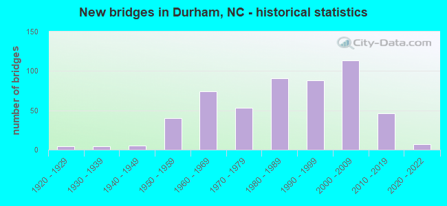
- New bridges - historical statistics
- 41920-1929
- 41930-1939
- 51940-1949
- 401950-1959
- 741960-1969
- 531970-1979
- 911980-1989
- 881990-1999
- 1132000-2009
- 462010-2019
- 72020-2022
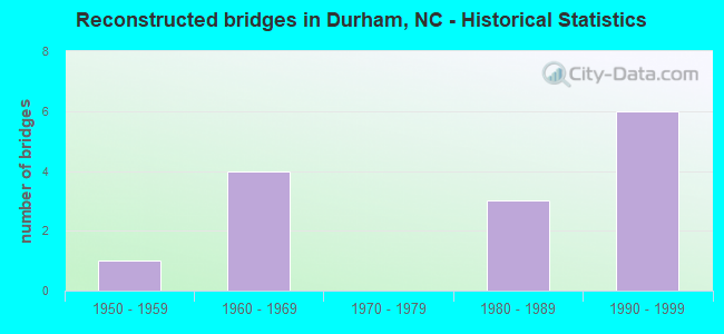
- Reconstructed bridges - Historical Statistics
- 11950-1959
- 41960-1969
- 01970-1979
- 31980-1989
- 61990-1999
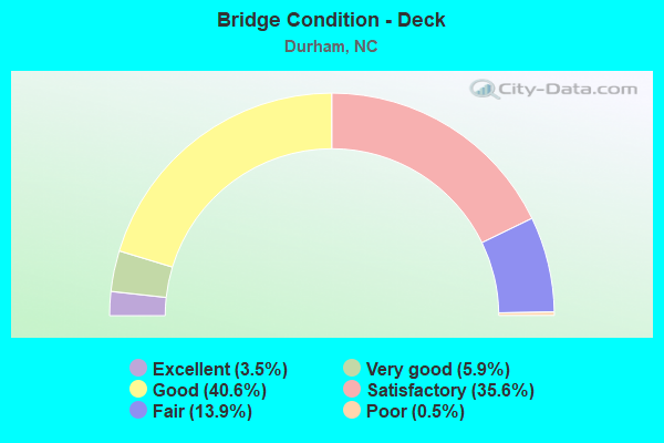
- Bridge Condition - Deck
- 3.5%Excellent
- 5.9%Very good
- 40.6%Good
- 35.6%Satisfactory
- 13.9%Fair
- 0.5%Poor
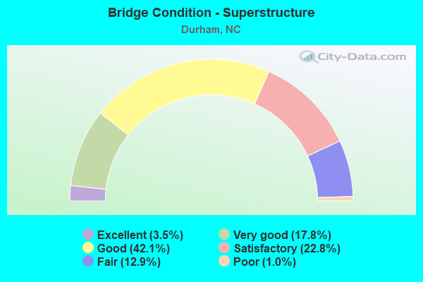
- Bridge Condition - Superstructure
- 3.5%Excellent
- 17.8%Very good
- 42.1%Good
- 22.8%Satisfactory
- 12.9%Fair
- 1.0%Poor
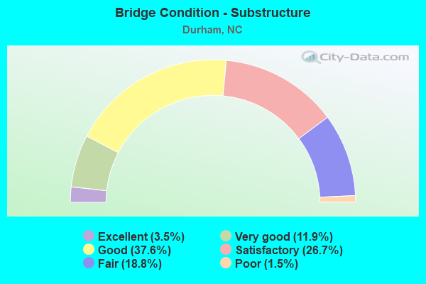
- Bridge Condition - Substructure
- 3.5%Excellent
- 11.9%Very good
- 37.6%Good
- 26.7%Satisfactory
- 18.8%Fair
- 1.5%Poor
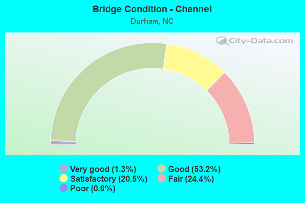
- Bridge Condition - Channel
- 1.3%Very good
- 53.2%Good
- 20.5%Satisfactory
- 24.4%Fair
- 0.6%Poor
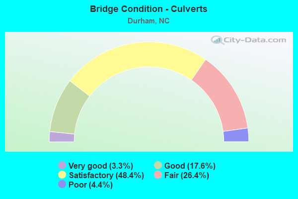
- Bridge Condition - Culverts
- 3.3%Very good
- 17.6%Good
- 48.4%Satisfactory
- 26.4%Fair
- 4.4%Poor
Find on map >> Show street view
Structure Number: 630043, Location: 0.4 MI N. OF US70 &SR1400 (Lat: 36.037983, Lng: -78.981131), Route carried "under" structure: Interstate 85, Year Built: 1997, Structure Length: 0. m, Average Daily Traffic: 31,000 (year 2017), Truck Traffic: 16%, Features Intersected: SR1400
Minimum Vertical Clearance: 5.82m (19.09ft), Kilometerpoint: 52.243, Lanes on structure: 2, Lanes under structure: 3, Material/Design: Steel continuous, Design/Construction: Stringer/Multi-beam, Length of Maximum Span: 37.7m (123.7ft)
Find on map >> Show street view
Structure Number: 630043, Location: 0.4 MI N. OF US70 &SR1400 (Lat: 36.037983, Lng: -78.981131), Route carried "under" structure: Interstate 85, Year Built: 1997, Structure Length: 0. m, Average Daily Traffic: 31,000 (year 2017), Truck Traffic: 16%, Features Intersected: SR1400
Minimum Vertical Clearance: 5.39m (17.68ft), Kilometerpoint: 52.243, Lanes on structure: 2, Lanes under structure: 3, Material/Design: Steel continuous, Design/Construction: Stringer/Multi-beam, Length of Maximum Span: 37.7m (123.7ft)
Find on map >> Show street view
Structure Number: 630048, Location: 0.43 MI.N.JCT.SR1209 (Lat: 35.968261, Lng: -78.962547), Route carried "under" structure: Business US 15, Year Built: 1981, Structure Length: 0. m, Average Daily Traffic: 10,000 (year 2019), Truck Traffic: 12%, Features Intersected: US15/501N.RMP
Minimum Vertical Clearance: 5.12m (16.80ft), Kilometerpoint: 0.000, Lanes on structure: 5, Lanes under structure: 2, Material/Design: Steel, Design/Construction: Stringer/Multi-beam, Length of Maximum Span: 37.4m (122.7ft)
Find on map >> Show street view
Structure Number: 630048, Location: 0.43 MI.N.JCT.SR1209 (Lat: 35.968261, Lng: -78.962547), Route carried "under" structure: Business US 15, Year Built: 1981, Structure Length: 0. m, Average Daily Traffic: 10,000 (year 2019), Truck Traffic: 12%, Features Intersected: US15/501N.RMP
Minimum Vertical Clearance: 5.24m (17.19ft), Kilometerpoint: 0.000, Lanes on structure: 5, Lanes under structure: 4, Material/Design: Steel, Design/Construction: Stringer/Multi-beam, Length of Maximum Span: 37.4m (122.7ft)
Find on map >> Show street view
Structure Number: 630053, Location: 0.36 MI.E.JCT.SR1800 (Lat: 36.010083, Lng: -78.867581), Route carried "under" structure: Interstate 1670, Year Built: 2002, Structure Length: 0. m, Average Daily Traffic: 6,400 (year 2015), Truck Traffic: 7%, Features Intersected: US70 EB
Minimum Vertical Clearance: 4.96m (16.27ft), Kilometerpoint: 0.000, Lanes on structure: 4, Lanes under structure: 3, Material/Design: Steel, Design/Construction: Stringer/Multi-beam, Length of Maximum Span: 40.2m (131.9ft)
Find on map >> Show street view
Structure Number: 63006, Location: 0.36 MI.E.JCT.SR1800 (Lat: 36.010203, Lng: -78.867381), Route carried "under" structure: State highway 1670, Year Built: 2002, Structure Length: 0. m, Average Daily Traffic: 6,400 (year 2015), Truck Traffic: 7%, Features Intersected: US70W
Minimum Vertical Clearance: 4.78m (15.68ft), Kilometerpoint: 0.000, Lanes on structure: 3, Lanes under structure: 2, Material/Design: Steel, Design/Construction: Stringer/Multi-beam, Length of Maximum Span: 40.2m (131.9ft)
Find on map >> Show street view
Structure Number: 630063, Location: 50' W. JCT. SR1358 (Lat: 35.974014, Lng: -78.960336), Route carried "under" structure: Bypass US 15, Year Built: 1996, Structure Length: 0. m, Average Daily Traffic: 31,750 (year 2019), Truck Traffic: 12%, Features Intersected: SR1303
Minimum Vertical Clearance: 5.36m (17.59ft), Kilometerpoint: 0.000, Lanes on structure: 2, Lanes under structure: 4, Material/Design: Steel continuous, Design/Construction: Stringer/Multi-beam, Length of Maximum Span: 32.6m (107.0ft)
Find on map >> Show street view
Structure Number: 630063, Location: 50' W. JCT. SR1358 (Lat: 35.974014, Lng: -78.960336), Route carried "under" structure: Bypass US 15, Year Built: 1996, Structure Length: 0. m, Average Daily Traffic: 31,750 (year 2019), Truck Traffic: 12%, Features Intersected: SR1303
Minimum Vertical Clearance: 5.05m (16.57ft), Kilometerpoint: 0.000, Lanes on structure: 2, Lanes under structure: 3, Material/Design: Steel continuous, Design/Construction: Stringer/Multi-beam, Length of Maximum Span: 32.6m (107.0ft)
Find on map >> Show street view
Structure Number: 630071, Location: .1MI.N. JCT US15/501(BUS) (Lat: 35.990136, Lng: -78.903056), Route carried "under" structure: State highway 147, Year Built: 1968, Structure Length: 0. m, Average Daily Traffic: 33,750 (year 2019), Truck Traffic: 12%, Features Intersected: US15/501 S
Minimum Vertical Clearance: 5.12m (16.80ft), Kilometerpoint: 0.000, Lanes on structure: 4, Lanes under structure: 2, Material/Design: Steel, Design/Construction: Stringer/Multi-beam, Length of Maximum Span: 18.5m (60.7ft)
Find on map >> Show street view
Structure Number: 630071, Location: .1MI.N. JCT US15/501(BUS) (Lat: 35.990136, Lng: -78.903056), Route carried "under" structure: State highway 147, Year Built: 1968, Structure Length: 0. m, Average Daily Traffic: 33,750 (year 2019), Truck Traffic: 12%, Features Intersected: US15/501 S
Minimum Vertical Clearance: 6.15m (20.18ft), Kilometerpoint: 0.000, Lanes on structure: 4, Lanes under structure: 2, Material/Design: Steel, Design/Construction: Stringer/Multi-beam, Length of Maximum Span: 18.5m (60.7ft)
Find on map >> Show street view
Structure Number: 63008, Location: 0.2MI.N.JCT.SR1303 (Lat: 35.983753, Lng: -78.957892), Route carried "under" structure: State highway 1308, Year Built: 1956, Structure Length: 0. m, Average Daily Traffic: 11,000 (year 2019), Truck Traffic: 6%, Features Intersected: US15/US501NBL
Minimum Vertical Clearance: 4.60m (15.09ft), Kilometerpoint: 0.000, Lanes on structure: 2, Lanes under structure: 3, Material/Design: Steel, Design/Construction: Stringer/Multi-beam, Length of Maximum Span: 17.0m (55.8ft)
Find on map >> Show street view
Structure Number: 630083, Location: 0.2MI.N.JCT.SR1303 (Lat: 35.983833, Lng: -78.958092), Route carried "under" structure: State highway 1308, Year Built: 1971, Structure Length: 0. m, Average Daily Traffic: 11,000 (year 2019), Truck Traffic: 6%, Features Intersected: US15/US501
Minimum Vertical Clearance: 4.69m (15.39ft), Kilometerpoint: 0.000, Lanes on structure: 2, Lanes under structure: 3, Material/Design: Steel, Design/Construction: Stringer/Multi-beam, Length of Maximum Span: 27.4m (89.9ft)
Find on map >> Show street view
Structure Number: 630099, Location: 0.24 MI S JCT S1303 (Lat: 35.972131, Lng: -78.943219), Route carried "under" structure: Business US 15, Year Built: 1951, Structure Length: 0. m, Average Daily Traffic: 9,250 (year 2019), Truck Traffic: 12%, Features Intersected: NC751
Minimum Vertical Clearance: 4.63m (15.19ft), Kilometerpoint: 0.000, Lanes on structure: 2, Lanes under structure: 2, Material/Design: Steel, Design/Construction: Stringer/Multi-beam, Length of Maximum Span: 17.3m (56.8ft)
Find on map >> Show street view
Structure Number: 6301, Location: 0.25 MI.N.JCT.NC54 (Lat: 35.902650, Lng: -78.879414), Route carried "under" structure: Interstate 40, Year Built: 1966, Structure Length: 0. m, Average Daily Traffic: 67,500 (year 2018), Truck Traffic: 16%, Features Intersected: SR2028
Minimum Vertical Clearance: 5.36m (17.59ft), Kilometerpoint: 85.040, Lanes on structure: 2, Lanes under structure: 4, Material/Design: Steel, Design/Construction: Stringer/Multi-beam, Length of Maximum Span: 25.2m (82.7ft)
Find on map >> Show street view
Structure Number: 6301, Location: 0.25 MI.N.JCT.NC54 (Lat: 35.902650, Lng: -78.879414), Route carried "under" structure: Ramp Interstate 40, Year Built: 1966, Structure Length: 0. m, Average Daily Traffic: 16,000 (year 2015), Truck Traffic: 16%, Features Intersected: SR2028
Minimum Vertical Clearance: 5.33m (17.49ft), Kilometerpoint: 0.000, Lanes on structure: 2, Lanes under structure: 1, Material/Design: Steel, Design/Construction: Stringer/Multi-beam, Length of Maximum Span: 25.2m (82.7ft)
Find on map >> Show street view
Structure Number: 6301, Location: 0.25 MI.N.JCT.NC54 (Lat: 35.902650, Lng: -78.879414), Route carried "under" structure: Interstate 40, Year Built: 1966, Structure Length: 0. m, Average Daily Traffic: 67,500 (year 2018), Truck Traffic: 16%, Features Intersected: SR2028
Minimum Vertical Clearance: 5.63m (18.47ft), Kilometerpoint: 85.040, Lanes on structure: 2, Lanes under structure: 3, Material/Design: Steel, Design/Construction: Stringer/Multi-beam, Length of Maximum Span: 25.2m (82.7ft)
Find on map >> Show street view
Structure Number: 630101, Location: 0.6 MI. N. JCT. SR1670 (Lat: 36.005342, Lng: -78.864486), Route carried "under" structure: Bypass US 70, Year Built: 2002, Structure Length: 0. m, Average Daily Traffic: 27,500 (year 2015), Truck Traffic: 12%, Features Intersected: SR1800
Minimum Vertical Clearance: 6.09m (19.98ft), Kilometerpoint: 87.173, Lanes on structure: 5, Lanes under structure: 3, Material/Design: Steel continuous, Design/Construction: Stringer/Multi-beam, Length of Maximum Span: 44.1m (144.7ft)
Find on map >> Show street view
Structure Number: 630101, Location: 0.6 MI. N. JCT. SR1670 (Lat: 36.005342, Lng: -78.864486), Route carried "under" structure: Bypass US 70, Year Built: 2002, Structure Length: 0. m, Average Daily Traffic: 27,500 (year 2015), Truck Traffic: 12%, Features Intersected: SR1800
Minimum Vertical Clearance: 8.16m (26.77ft), Kilometerpoint: 87.173, Lanes on structure: 5, Lanes under structure: 4, Material/Design: Steel continuous, Design/Construction: Stringer/Multi-beam, Length of Maximum Span: 44.1m (144.7ft)
Find on map >> Show street view
Structure Number: 630108, Location: 0.2 MI. N. OF JCT. US70 (Lat: 36.025278, Lng: -78.953611), Route carried "under" structure: State highway 1401, Year Built: 1997, Structure Length: 0. m, Average Daily Traffic: 10,250 (year 2019), Truck Traffic: 6%, Features Intersected: I85N,US70W,BYP.
Minimum Vertical Clearance: 5.08m (16.67ft), Kilometerpoint: 0.000, Lanes on structure: 3, Lanes under structure: 4, Material/Design: Steel continuous, Design/Construction: Stringer/Multi-beam, Length of Maximum Span: 41.1m (134.8ft)
Find on map >> Show street view
Structure Number: 630108, Location: 0.2 MI. N. OF JCT. US70 (Lat: 36.025278, Lng: -78.953611), Route carried "under" structure: State highway 1401, Year Built: 1997, Structure Length: 0. m, Average Daily Traffic: 10,250 (year 2019), Truck Traffic: 6%, Features Intersected: I85N,US70W,BYP.
Minimum Vertical Clearance: 5.66m (18.57ft), Kilometerpoint: 0.000, Lanes on structure: 3, Lanes under structure: 4, Material/Design: Steel continuous, Design/Construction: Stringer/Multi-beam, Length of Maximum Span: 41.1m (134.8ft)
Find on map >> Show street view
Structure Number: 630109, Location: 1.0 MI. S. JCT. SR1317 (Lat: 35.998672, Lng: -78.958114), Route carried "under" structure: State highway 751, Year Built: 1956, Structure Length: 0. m, Average Daily Traffic: 16,500 (year 2019), Truck Traffic: 12%, Features Intersected: US15/501 NBL
Minimum Vertical Clearance: 4.96m (16.27ft), Kilometerpoint: 0.000, Lanes on structure: 2, Lanes under structure: 4, Material/Design: Steel, Design/Construction: Stringer/Multi-beam, Length of Maximum Span: 17.3m (56.8ft)
Find on map >> Show street view
Structure Number: 630112, Location: 1.0 MI S JCT SR 1321. (Lat: 36.025456, Lng: -78.953711), Route carried "under" structure: State highway 1401, Year Built: 1998, Structure Length: 0. m, Average Daily Traffic: 10,250 (year 2019), Truck Traffic: 6%, Features Intersected: I85SB.,US70W-BYP.
Minimum Vertical Clearance: 5.46m (17.91ft), Kilometerpoint: 0.000, Lanes on structure: 3, Lanes under structure: 4, Material/Design: Steel, Design/Construction: Stringer/Multi-beam, Length of Maximum Span: 41.1m (134.8ft)
Find on map >> Show street view
Structure Number: 630112, Location: 1.0 MI S JCT SR 1321. (Lat: 36.025456, Lng: -78.953711), Route carried "under" structure: State highway 1401, Year Built: 1998, Structure Length: 0. m, Average Daily Traffic: 10,250 (year 2019), Truck Traffic: 6%, Features Intersected: I85SB.,US70W-BYP.
Minimum Vertical Clearance: 5.05m (16.57ft), Kilometerpoint: 0.000, Lanes on structure: 3, Lanes under structure: 4, Material/Design: Steel, Design/Construction: Stringer/Multi-beam, Length of Maximum Span: 41.1m (134.8ft)
Find on map >> Show street view
Structure Number: 630113, Location: 1.0 MI S JCT SR 1317 (Lat: 35.998717, Lng: -78.958311), Route carried "under" structure: State highway 751, Year Built: 1971, Structure Length: 0. m, Average Daily Traffic: 16,500 (year 2019), Truck Traffic: 6%, Features Intersected: US15BYP,US501
Minimum Vertical Clearance: 4.75m (15.58ft), Kilometerpoint: 0.000, Lanes on structure: 2, Lanes under structure: 4, Material/Design: Steel, Design/Construction: Stringer/Multi-beam, Length of Maximum Span: 23.4m (76.8ft)
Find on map >> Show street view
Structure Number: 630129, Location: .7 MI. N. OF JCT. SR 1320 (Lat: 36.011675, Lng: -78.955328), Route carried "under" structure: Bypass US 15, Year Built: 1993, Structure Length: 0. m, Average Daily Traffic: 21,500 (year 2015), Truck Traffic: 12%, Features Intersected: SR1317
Minimum Vertical Clearance: 5.12m (16.80ft), Kilometerpoint: 0.000, Lanes on structure: 2, Lanes under structure: 3, Material/Design: Steel, Design/Construction: Stringer/Multi-beam, Length of Maximum Span: 26.2m (86.0ft)
Find on map >> Show street view
Structure Number: 630129, Location: .7 MI. N. OF JCT. SR 1320 (Lat: 36.011675, Lng: -78.955328), Route carried "under" structure: Bypass US 15, Year Built: 1993, Structure Length: 0. m, Average Daily Traffic: 20,500 (year 2015), Truck Traffic: 12%, Features Intersected: SR1317
Minimum Vertical Clearance: 5.24m (17.19ft), Kilometerpoint: 0.000, Lanes on structure: 2, Lanes under structure: 4, Material/Design: Steel, Design/Construction: Stringer/Multi-beam, Length of Maximum Span: 26.2m (86.0ft)
Find on map >> Show street view
Structure Number: 63013, Location: 0.6 MI. S. JCT. SR1407 (Lat: 36.028578, Lng: -78.935856), Route carried "under" structure: Interstate 85, Year Built: 2006, Structure Length: 0. m, Average Daily Traffic: 46,500 (year 2015), Truck Traffic: 16%, Features Intersected: SR1321
Minimum Vertical Clearance: 8.07m (26.48ft), Kilometerpoint: 53.127, Lanes on structure: 6, Lanes under structure: 5, Material/Design: Steel, Design/Construction: Stringer/Multi-beam, Length of Maximum Span: 43.2m (141.7ft)
Find on map >> Show street view
Structure Number: 63013, Location: 0.6 MI. S. JCT. SR1407 (Lat: 36.028578, Lng: -78.935856), Route carried "under" structure: Interstate 85, Year Built: 2006, Structure Length: 0. m, Average Daily Traffic: 46,500 (year 2015), Truck Traffic: 16%, Features Intersected: SR1321
Minimum Vertical Clearance: 6.93m (22.74ft), Kilometerpoint: 53.127, Lanes on structure: 6, Lanes under structure: 5, Material/Design: Steel, Design/Construction: Stringer/Multi-beam, Length of Maximum Span: 43.2m (141.7ft)
Find on map >> Show street view
Structure Number: 630132, Location: 0.6 MI.N.JCT.I-85 &SR1321 (Lat: 36.028508, Lng: -78.925236), Route carried "under" structure: State highway 157, Year Built: 2006, Structure Length: 0. m, Average Daily Traffic: 14,500 (year 2019), Truck Traffic: 6%, Features Intersected: I85,US15-501,US70
Minimum Vertical Clearance: 4.87m (15.98ft), Kilometerpoint: 53.310, Lanes on structure: 5, Lanes under structure: 4, Material/Design: Steel continuous, Design/Construction: Stringer/Multi-beam, Length of Maximum Span: 41.4m (135.8ft)
Find on map >> Show street view
Structure Number: 630135, Location: 0.2 MI. N. JCT. SR1401 (Lat: 36.024433, Lng: -78.947647), Route carried "under" structure: Interstate 85, Year Built: 2006, Structure Length: 0. m, Average Daily Traffic: 24,000 (year 2019), Truck Traffic: 16%, Features Intersected: US15/501 SBL
Minimum Vertical Clearance: 5.41m (17.75ft), Kilometerpoint: 53.828, Lanes on structure: 3, Lanes under structure: 4, Material/Design: Steel continuous, Design/Construction: Stringer/Multi-beam, Length of Maximum Span: 61.8m (202.8ft)
Find on map >> Show street view
Structure Number: 630135, Location: 0.2 MI. N. JCT. SR1401 (Lat: 36.024433, Lng: -78.947647), Route carried "under" structure: Interstate 85, Year Built: 2006, Structure Length: 0. m, Average Daily Traffic: 24,000 (year 2019), Truck Traffic: 16%, Features Intersected: US15/501 SBL
Minimum Vertical Clearance: 5.73m (18.80ft), Kilometerpoint: 53.828, Lanes on structure: 3, Lanes under structure: 3, Material/Design: Steel continuous, Design/Construction: Stringer/Multi-beam, Length of Maximum Span: 61.8m (202.8ft)
Find on map >> Show street view
Structure Number: 630136, Location: 0.7 MI.S.JCT.I85&US501 (Lat: 36.025167, Lng: -78.916728), Route carried "under" structure: Interstate 85, Year Built: 2006, Structure Length: 0. m, Average Daily Traffic: 52,000 (year 2019), Truck Traffic: 16%, Features Intersected: BROAD ST.
Minimum Vertical Clearance: 5.28m (17.32ft), Kilometerpoint: 53.493, Lanes on structure: 4, Lanes under structure: 6, Material/Design: Steel continuous, Design/Construction: Stringer/Multi-beam, Length of Maximum Span: 30.7m (100.7ft)
Find on map >> Show street view
Structure Number: 630136, Location: 0.7 MI.S.JCT.I85&US501 (Lat: 36.025167, Lng: -78.916728), Route carried "under" structure: Interstate 85, Year Built: 2006, Structure Length: 0. m, Average Daily Traffic: 52,000 (year 2019), Truck Traffic: 16%, Features Intersected: BROAD ST.
Minimum Vertical Clearance: 5.30m (17.39ft), Kilometerpoint: 53.493, Lanes on structure: 4, Lanes under structure: 5, Material/Design: Steel continuous, Design/Construction: Stringer/Multi-beam, Length of Maximum Span: 30.7m (100.7ft)
Find on map >> Show street view
Structure Number: 630137, Location: 0.15 MI.S.JCT.US70 BUS. (Lat: 36.003856, Lng: -78.920631), Route carried "under" structure: State highway 147, Year Built: 1974, Structure Length: 0. m, Average Daily Traffic: 34,000 (year 2019), Truck Traffic: 12%, Features Intersected: SR1322
Minimum Vertical Clearance: 5.24m (17.19ft), Kilometerpoint: 0.000, Lanes on structure: 4, Lanes under structure: 3, Material/Design: Steel continuous, Design/Construction: Stringer/Multi-beam, Length of Maximum Span: 23.1m (75.8ft)
Find on map >> Show street view
Structure Number: 630137, Location: 0.15 MI.S.JCT.US70 BUS. (Lat: 36.003856, Lng: -78.920631), Route carried "under" structure: State highway 147, Year Built: 1974, Structure Length: 0. m, Average Daily Traffic: 34,000 (year 2019), Truck Traffic: 12%, Features Intersected: SR1322
Minimum Vertical Clearance: 5.85m (19.19ft), Kilometerpoint: 0.000, Lanes on structure: 4, Lanes under structure: 2, Material/Design: Steel continuous, Design/Construction: Stringer/Multi-beam, Length of Maximum Span: 23.1m (75.8ft)
Find on map >> Show street view
Structure Number: 630138, Location: 0.4 MI.S. OF JCT.SR1320 (Lat: 36.002158, Lng: -78.917933), Route carried "under" structure: City street , Year Built: 1974, Structure Length: 0. m, Average Daily Traffic: 100 (year 2000), Truck Traffic: 7%, Features Intersected: NC147 SBL, Facility Carried by Structure: CAMPUSDRIVE
Minimum Vertical Clearance: 6.57m (21.56ft), Kilometerpoint: 0.000, Lanes on structure: 2, Lanes under structure: 2, Material/Design: Steel continuous, Design/Construction: Stringer/Multi-beam, Length of Maximum Span: 14.9m (48.9ft)
Find on map >> Show street view
Structure Number: 63014, Location: 0.4 MI.S. OF JCT.SR1320 (Lat: 36.002311, Lng: -78.917825), Route carried "under" structure: City street , Year Built: 1974, Structure Length: 0. m, Average Daily Traffic: 5,000 (year 1991), Truck Traffic: 7%, Features Intersected: NC147 NBL, Facility Carried by Structure: CAMPUSDRIVE
Minimum Vertical Clearance: 6.29m (20.64ft), Kilometerpoint: 0.000, Lanes on structure: 3, Lanes under structure: 2, Material/Design: Steel continuous, Design/Construction: Stringer/Multi-beam, Length of Maximum Span: 14.9m (48.9ft)
Find on map >> Show street view
Structure Number: 630142, Location: 0.9 MI.S.JCT.SR1322 (Lat: 35.999875, Lng: -78.914014), Route carried "under" structure: City street , Year Built: 1974, Structure Length: 0. m, Average Daily Traffic: 8,000 (year 2009), Truck Traffic: 7%, Features Intersected: NC147S., Facility Carried by Structure: BUCHANANBLVD.
Minimum Vertical Clearance: 5.08m (16.67ft), Kilometerpoint: 0.000, Lanes on structure: 3, Lanes under structure: 2, Material/Design: Steel continuous, Design/Construction: Stringer/Multi-beam, Length of Maximum Span: 24.3m (79.7ft)
Find on map >> Show street view
Structure Number: 630144, Location: 0.9M. S. JCT. SR1322 (Lat: 36.000058, Lng: -78.913947), Route carried "under" structure: City street , Year Built: 1974, Structure Length: 0. m, Average Daily Traffic: 8,000 (year 2009), Truck Traffic: 7%, Features Intersected: NC147N, Facility Carried by Structure: BUCHANAN BLVD
Minimum Vertical Clearance: 5.66m (18.57ft), Kilometerpoint: 0.000, Lanes on structure: 3, Lanes under structure: 2, Material/Design: Steel continuous, Design/Construction: Stringer/Multi-beam, Length of Maximum Span: 24.0m (78.7ft)
Find on map >> Show street view
Structure Number: 630147, Location: 0.1 MI.W.SR1361 (Lat: 35.996933, Lng: -78.912036), Route carried "under" structure: State highway 147, Year Built: 1968, Structure Length: 0. m, Average Daily Traffic: 33,750 (year 2015), Truck Traffic: 12%, Features Intersected: SR1127
Minimum Vertical Clearance: 5.09m (16.70ft), Kilometerpoint: 0.000, Lanes on structure: 5, Lanes under structure: 2, Material/Design: Prestressed concrete, Design/Construction: Stringer/Multi-beam, Length of Maximum Span: 19.5m (64.0ft)
Find on map >> Show street view
Structure Number: 630147, Location: 0.1 MI.W.SR1361 (Lat: 35.996933, Lng: -78.912036), Route carried "under" structure: State highway 147, Year Built: 1968, Structure Length: 0. m, Average Daily Traffic: 33,750 (year 2019), Truck Traffic: 12%, Features Intersected: SR1127
Minimum Vertical Clearance: 4.99m (16.37ft), Kilometerpoint: 0.000, Lanes on structure: 5, Lanes under structure: 3, Material/Design: Prestressed concrete, Design/Construction: Stringer/Multi-beam, Length of Maximum Span: 19.5m (64.0ft)
Find on map >> Show street view
Structure Number: 630148, Location: 0.3MI.N.JCT.I85&US501BYP (Lat: 36.018714, Lng: -78.900481), Route carried "under" structure: Interstate 85, Year Built: 2007, Structure Length: 0. m, Average Daily Traffic: 44,000 (year 2018), Truck Traffic: 16%, Features Intersected: WASHINGTON ST.
Minimum Vertical Clearance: 6.27m (20.57ft), Kilometerpoint: 0.000, Lanes on structure: 2, Lanes under structure: 2, Material/Design: Steel continuous, Design/Construction: Stringer/Multi-beam, Length of Maximum Span: 45.7m (149.9ft)
Find on map >> Show street view
Structure Number: 630148, Location: 0.3MI.N.JCT.I85&US501BYP (Lat: 36.018714, Lng: -78.900481), Route carried "under" structure: Ramp Interstate 85, Year Built: 2007, Structure Length: 0. m, Average Daily Traffic: 29,333 (year 2018), Truck Traffic: 16%, Features Intersected: WASHINGTON ST.
Minimum Vertical Clearance: 5.60m (18.37ft), Kilometerpoint: 0.000, Lanes on structure: 2, Lanes under structure: 2, Material/Design: Steel continuous, Design/Construction: Stringer/Multi-beam, Length of Maximum Span: 45.7m (149.9ft)
Find on map >> Show street view
Structure Number: 630148, Location: 0.3MI.N.JCT.I85&US501BYP (Lat: 36.018714, Lng: -78.900481), Route carried "under" structure: Interstate 85, Year Built: 2007, Structure Length: 0. m, Average Daily Traffic: 44,000 (year 2018), Truck Traffic: 16%, Features Intersected: WASHINGTON ST.
Minimum Vertical Clearance: 6.18m (20.28ft), Kilometerpoint: 0.000, Lanes on structure: 2, Lanes under structure: 5, Material/Design: Steel continuous, Design/Construction: Stringer/Multi-beam, Length of Maximum Span: 45.7m (149.9ft)
Find on map >> Show street view
Structure Number: 63015, Location: 0.45MI.N.JCT.US501BYP (Lat: 36.017836, Lng: -78.898606), Route carried "under" structure: City street , Year Built: 2006, Structure Length: 0. m, Average Daily Traffic: 8,500 (year 2019), Truck Traffic: 7%, Features Intersected: I85S,US70, Facility Carried by Structure: W.CLUB BOULEVARD,E
Minimum Vertical Clearance: 4.72m (15.49ft), Kilometerpoint: 0.000, Lanes on structure: 7, Lanes under structure: 2, Material/Design: Steel, Design/Construction: Stringer/Multi-beam, Length of Maximum Span: 31.6m (103.7ft)
Find on map >> Show street view
Structure Number: 630154, Location: 0.2 MI.S.JCT.US70 BUS. (Lat: 35.994406, Lng: -78.911442), Route carried "under" structure: State highway 147, Year Built: 1968, Structure Length: 0. m, Average Daily Traffic: 33,750 (year 2019), Truck Traffic: 12%, Features Intersected: SR1361
Minimum Vertical Clearance: 6.61m (21.69ft), Kilometerpoint: 0.000, Lanes on structure: 3, Lanes under structure: 3, Material/Design: Steel, Design/Construction: Stringer/Multi-beam, Length of Maximum Span: 22.2m (72.8ft)
Find on map >> Show street view
Structure Number: 630154, Location: 0.2 MI.S.JCT.US70 BUS. (Lat: 35.994406, Lng: -78.911442), Route carried "under" structure: State highway 147, Year Built: 1968, Structure Length: 0. m, Average Daily Traffic: 33,750 (year 2019), Truck Traffic: 12%, Features Intersected: SR1361
Minimum Vertical Clearance: 6.43m (21.10ft), Kilometerpoint: 0.000, Lanes on structure: 3, Lanes under structure: 3, Material/Design: Steel, Design/Construction: Stringer/Multi-beam, Length of Maximum Span: 22.2m (72.8ft)
Find on map >> Show street view
Structure Number: 630156, Location: 0.3 MI.S.JCT.SR1127 (Lat: 35.992661, Lng: -78.908844), Route carried "under" structure: State highway 147, Year Built: 1968, Structure Length: 0. m, Average Daily Traffic: 33,750 (year 2019), Truck Traffic: 12%, Features Intersected: SR1445
Minimum Vertical Clearance: 5.60m (18.37ft), Kilometerpoint: 0.000, Lanes on structure: 3, Lanes under structure: 2, Material/Design: Steel, Design/Construction: Stringer/Multi-beam, Length of Maximum Span: 23.7m (77.8ft)
Find on map >> Show street view
Structure Number: 630156, Location: 0.3 MI.S.JCT.SR1127 (Lat: 35.992661, Lng: -78.908844), Route carried "under" structure: State highway 147, Year Built: 1968, Structure Length: 0. m, Average Daily Traffic: 33,750 (year 2019), Truck Traffic: 14%, Features Intersected: SR1445
Minimum Vertical Clearance: 4.99m (16.37ft), Kilometerpoint: 0.000, Lanes on structure: 3, Lanes under structure: 3, Material/Design: Steel, Design/Construction: Stringer/Multi-beam, Length of Maximum Span: 23.7m (77.8ft)
Find on map >> Show street view
Structure Number: 63016, Location: 0.2 MI.N.JCT.US501 (Lat: 35.991036, Lng: -78.906078), Route carried "under" structure: City street , Year Built: 1968, Structure Length: 0. m, Average Daily Traffic: 2,000 (year 2012), Truck Traffic: 7%, Features Intersected: NC147S, Facility Carried by Structure: BLACKWELL ST
Minimum Vertical Clearance: 5.69m (18.67ft), Kilometerpoint: 0.000, Lanes on structure: 3, Lanes under structure: 5, Material/Design: Steel, Design/Construction: Stringer/Multi-beam, Length of Maximum Span: 28.9m (94.8ft)
Find on map >> Show street view
Structure Number: 630161, Location: 0.19 M. S. JCT. NC55 (Lat: 36.014583, Lng: -78.890528), Route carried "under" structure: Business US 15, Year Built: 2005, Structure Length: 0. m, Average Daily Traffic: 8,500 (year 2018), Truck Traffic: 12%, Features Intersected: I85N,US15/501,US70
Minimum Vertical Clearance: 5.81m (19.06ft), Kilometerpoint: 0.000, Lanes on structure: 4, Lanes under structure: 4, Material/Design: Steel, Design/Construction: Stringer/Multi-beam, Length of Maximum Span: 34.4m (112.9ft)
Find on map >> Show street view
Structure Number: 630161, Location: 0.19 M. S. JCT. NC55 (Lat: 36.014583, Lng: -78.890528), Route carried "under" structure: Business US 15, Year Built: 2005, Structure Length: 0. m, Average Daily Traffic: 8,500 (year 2018), Truck Traffic: 12%, Features Intersected: I85N,US15/501,US70
Minimum Vertical Clearance: 6.07m (19.91ft), Kilometerpoint: 0.000, Lanes on structure: 4, Lanes under structure: 4, Material/Design: Steel, Design/Construction: Stringer/Multi-beam, Length of Maximum Span: 34.4m (112.9ft)
Find on map >> Show street view
Structure Number: 630162, Location: 0.19MI S. OF JCT NC55 (Lat: 36.014806, Lng: -78.890472), Route carried "under" structure: Business US 501, Year Built: 2006, Structure Length: 0. m, Average Daily Traffic: 8,500 (year 2015), Truck Traffic: 12%, Features Intersected: I85S,US15N,US70
Minimum Vertical Clearance: 5.63m (18.47ft), Kilometerpoint: 0.000, Lanes on structure: 4, Lanes under structure: 4, Material/Design: Steel, Design/Construction: Stringer/Multi-beam, Length of Maximum Span: 34.7m (113.8ft)
Find on map >> Show street view
Structure Number: 630162, Location: 0.19MI S. OF JCT NC55 (Lat: 36.014806, Lng: -78.890472), Route carried "under" structure: Business US 501, Year Built: 2006, Structure Length: 0. m, Average Daily Traffic: 8,500 (year 2015), Truck Traffic: 12%, Features Intersected: I85S,US15N,US70
Minimum Vertical Clearance: 5.30m (17.39ft), Kilometerpoint: 0.000, Lanes on structure: 4, Lanes under structure: 3, Material/Design: Steel, Design/Construction: Stringer/Multi-beam, Length of Maximum Span: 34.7m (113.8ft)
Find on map >> Show street view
Structure Number: 630163, Location: 0.2 MI. N. JCT. NC147 (Lat: 35.991208, Lng: -78.906003), Route carried "under" structure: City street , Year Built: 1968, Structure Length: 0. m, Average Daily Traffic: 1,500 (year 2018), Truck Traffic: 7%, Features Intersected: NC147N, Facility Carried by Structure: BLACKELLST.E
Minimum Vertical Clearance: 4.87m (15.98ft), Kilometerpoint: 0.000, Lanes on structure: 3, Lanes under structure: 2, Material/Design: Steel, Design/Construction: Stringer/Multi-beam, Length of Maximum Span: 28.9m (94.8ft)
Find on map >> Show street view
Structure Number: 630163, Location: 0.2 MI. N. JCT. NC147 (Lat: 35.991208, Lng: -78.906003), Route carried "under" structure: City street , Year Built: 1968, Structure Length: 0. m, Average Daily Traffic: 1,500 (year 2018), Truck Traffic: 7%, Features Intersected: NC147N, Facility Carried by Structure: BLACKWELLST.W
Minimum Vertical Clearance: 4.87m (15.98ft), Kilometerpoint: 0.000, Lanes on structure: 3, Lanes under structure: 2, Material/Design: Steel, Design/Construction: Stringer/Multi-beam, Length of Maximum Span: 28.9m (94.8ft)
Find on map >> Show street view
Structure Number: 630164, Location: 0.1 MI.S.JCT.US15/501 SBL (Lat: 35.989383, Lng: -78.901386), Route carried "under" structure: Business US 15, Year Built: 1968, Structure Length: 0. m, Average Daily Traffic: 9,200 (year 2015), Truck Traffic: 12%, Features Intersected: NC147S.
Minimum Vertical Clearance: 5.97m (19.59ft), Kilometerpoint: 0.000, Lanes on structure: 2, Lanes under structure: 4, Material/Design: Steel, Design/Construction: Stringer/Multi-beam, Length of Maximum Span: 21.6m (70.9ft)
Find on map >> Show street view
Structure Number: 630166, Location: 0.1 MI.S.JCT.US15/501 S. (Lat: 35.989536, Lng: -78.901283), Route carried "under" structure: Business US 15, Year Built: 1968, Structure Length: 0. m, Average Daily Traffic: 9,200 (year 2015), Truck Traffic: 12%, Features Intersected: NC147N.
Minimum Vertical Clearance: 4.99m (16.37ft), Kilometerpoint: 0.000, Lanes on structure: 2, Lanes under structure: 4, Material/Design: Steel, Design/Construction: Stringer/Multi-beam, Length of Maximum Span: 21.6m (70.9ft)
Find on map >> Show street view
Structure Number: 630167, Location: 1.1 MI. N. JCT. US501 (Lat: 36.014083, Lng: -78.887389), Route carried "under" structure: State highway 55, Year Built: 2005, Structure Length: 0. m, Average Daily Traffic: 10,000 (year 2019), Truck Traffic: 6%, Features Intersected: I85N
Minimum Vertical Clearance: 6.80m (22.31ft), Kilometerpoint: 0.000, Lanes on structure: 4, Lanes under structure: 4, Material/Design: Steel, Design/Construction: Stringer/Multi-beam, Length of Maximum Span: 42.9m (140.7ft)
Find on map >> Show street view
Structure Number: 630167, Location: 1.1 MI. N. JCT. US501 (Lat: 36.014083, Lng: -78.887389), Route carried "under" structure: State highway 55, Year Built: 2005, Structure Length: 0. m, Average Daily Traffic: 10,000 (year 2019), Truck Traffic: 6%, Features Intersected: I85N
Minimum Vertical Clearance: 6.24m (20.47ft), Kilometerpoint: 0.000, Lanes on structure: 4, Lanes under structure: 3, Material/Design: Steel, Design/Construction: Stringer/Multi-beam, Length of Maximum Span: 42.9m (140.7ft)
Find on map >> Show street view
Structure Number: 630168, Location: 2.36MI.S. JCT. SR1671 (Lat: 36.014303, Lng: -78.887525), Route carried "under" structure: State highway 55, Year Built: 2006, Structure Length: 0. m, Average Daily Traffic: 10,000 (year 2019), Truck Traffic: 6%, Features Intersected: I85S, US15S
Minimum Vertical Clearance: 6.21m (20.37ft), Kilometerpoint: 0.000, Lanes on structure: 4, Lanes under structure: 4, Material/Design: Steel, Design/Construction: Stringer/Multi-beam, Length of Maximum Span: 42.9m (140.7ft)
Find on map >> Show street view
Structure Number: 630168, Location: 2.36MI.S. JCT. SR1671 (Lat: 36.014303, Lng: -78.887525), Route carried "under" structure: State highway 55, Year Built: 2006, Structure Length: 0. m, Average Daily Traffic: 10,000 (year 2019), Truck Traffic: 6%, Features Intersected: I85S, US15S
Minimum Vertical Clearance: 6.43m (21.10ft), Kilometerpoint: 0.000, Lanes on structure: 4, Lanes under structure: 3, Material/Design: Steel, Design/Construction: Stringer/Multi-beam, Length of Maximum Span: 42.9m (140.7ft)
Find on map >> Show street view
Structure Number: 630169, Location: 100' S. JCT. SR1364 (Lat: 35.987853, Lng: -78.897106), Route carried "under" structure: State highway 147, Year Built: 1968, Structure Length: 0. m, Average Daily Traffic: 39,000 (year 2015), Truck Traffic: 12%, Features Intersected: SR1118
Minimum Vertical Clearance: 6.79m (22.28ft), Kilometerpoint: 0.000, Lanes on structure: 6, Lanes under structure: 3, Material/Design: Steel, Design/Construction: Stringer/Multi-beam, Length of Maximum Span: 21.0m (68.9ft)
Find on map >> Show street view
Structure Number: 630169, Location: 100' S. JCT. SR1364 (Lat: 35.987853, Lng: -78.897106), Route carried "under" structure: State highway 147, Year Built: 1968, Structure Length: 0. m, Average Daily Traffic: 39,000 (year 2015), Truck Traffic: 12%, Features Intersected: SR1118
Minimum Vertical Clearance: 5.51m (18.08ft), Kilometerpoint: 0.000, Lanes on structure: 6, Lanes under structure: 3, Material/Design: Steel, Design/Construction: Stringer/Multi-beam, Length of Maximum Span: 21.0m (68.9ft)
Find on map >> Show street view
Structure Number: 630173, Location: 0.3 MI.N.NC147 & NC55 (Lat: 35.983908, Lng: -78.893381), Route carried "under" structure: City street , Year Built: 1968, Structure Length: 0. m, Average Daily Traffic: 3,300 (year 1994), Truck Traffic: 7%, Features Intersected: NC147S., Facility Carried by Structure: GRANTST.
Minimum Vertical Clearance: 6.33m (20.77ft), Kilometerpoint: 0.000, Lanes on structure: 3, Lanes under structure: 2, Material/Design: Steel, Design/Construction: Stringer/Multi-beam, Length of Maximum Span: 20.4m (66.9ft)
Find on map >> Show street view
Structure Number: 630175, Location: 0.3 MI.N.JCT.NC147 & NC55 (Lat: 35.984081, Lng: -78.893283), Route carried "under" structure: City street , Year Built: 1968, Structure Length: 0. m, Average Daily Traffic: 333 (year 2000), Truck Traffic: 7%, Features Intersected: NC147N, Facility Carried by Structure: GRANT STREET
Minimum Vertical Clearance: 4.66m (15.29ft), Kilometerpoint: 0.000, Lanes on structure: 3, Lanes under structure: 2, Material/Design: Steel, Design/Construction: Stringer/Multi-beam, Length of Maximum Span: 20.4m (66.9ft)
Find on map >> Show street view
Structure Number: 630177, Location: 0.4 MI.S.JCT.NC55 (Lat: 35.979197, Lng: -78.883106), Route carried "under" structure: City street , Year Built: 1970, Structure Length: 0. m, Average Daily Traffic: 7,600 (year 1986), Truck Traffic: 7%, Features Intersected: NC147 SBL, Facility Carried by Structure: BACON STREET
Minimum Vertical Clearance: 4.87m (15.98ft), Kilometerpoint: 0.000, Lanes on structure: 2, Lanes under structure: 2, Material/Design: Steel, Design/Construction: Stringer/Multi-beam, Length of Maximum Span: 19.2m (63.0ft)
Find on map >> Show street view
Structure Number: 630179, Location: 0.5 MI. N. JCT. NC55 (Lat: 36.013422, Lng: -78.877553), Route carried "under" structure: State highway 1671, Year Built: 2001, Structure Length: 0. m, Average Daily Traffic: 2,600 (year 2015), Truck Traffic: 7%, Features Intersected: I85, US15, US70
Minimum Vertical Clearance: 5.33m (17.49ft), Kilometerpoint: 0.000, Lanes on structure: 10, Lanes under structure: 2, Material/Design: Steel, Design/Construction: Stringer/Multi-beam, Length of Maximum Span: 43.5m (142.7ft)
Find on map >> Show street view
Structure Number: 63018, Location: 0.4 MI.S.JCT.NC55 (Lat: 35.979358, Lng: -78.883014), Route carried "under" structure: City street , Year Built: 1970, Structure Length: 0. m, Average Daily Traffic: 7,600 (year 1989), Truck Traffic: 7%, Features Intersected: NC147 NBL, Facility Carried by Structure: BACON STREET
Minimum Vertical Clearance: 5.09m (16.70ft), Kilometerpoint: 0.000, Lanes on structure: 2, Lanes under structure: 2, Material/Design: Steel, Design/Construction: Stringer/Multi-beam, Length of Maximum Span: 19.2m (63.0ft)
Find on map >> Show street view
Structure Number: 630186, Location: @ JCT.BRIGGS AVE&NC147 (Lat: 35.976475, Lng: -78.875819), Route carried "under" structure: State highway 147, Year Built: 1969, Structure Length: 0. m, Average Daily Traffic: 34,000 (year 2018), Truck Traffic: 12%, Features Intersected: BRIGGS AVENUE
Minimum Vertical Clearance: 5.66m (18.57ft), Kilometerpoint: 0.000, Lanes on structure: 5, Lanes under structure: 2, Material/Design: Prestressed concrete, Design/Construction: Stringer/Multi-beam, Length of Maximum Span: 21.6m (70.9ft)
Find on map >> Show street view
Structure Number: 630186, Location: @ JCT.BRIGGS AVE&NC147 (Lat: 35.976475, Lng: -78.875819), Route carried "under" structure: State highway 147, Year Built: 1969, Structure Length: 0. m, Average Daily Traffic: 34,000 (year 2018), Truck Traffic: 12%, Features Intersected: BRIGGS AVENUE
Minimum Vertical Clearance: 5.21m (17.09ft), Kilometerpoint: 0.000, Lanes on structure: 5, Lanes under structure: 3, Material/Design: Prestressed concrete, Design/Construction: Stringer/Multi-beam, Length of Maximum Span: 21.6m (70.9ft)
Find on map >> Show street view
Structure Number: 63019, Location: 0.18 MI. W. JCT. SR1670 (Lat: 36.015825, Lng: -78.865700), Route carried "under" structure: Interstate 85, Year Built: 2002, Structure Length: 0. m, Average Daily Traffic: 32,000 (year 2019), Truck Traffic: 16%, Features Intersected: SR1827
Minimum Vertical Clearance: 5.63m (18.47ft), Kilometerpoint: 54.407, Lanes on structure: 2, Lanes under structure: 4, Material/Design: Steel continuous, Design/Construction: Stringer/Multi-beam, Length of Maximum Span: 50.2m (164.7ft)
Find on map >> Show street view
Structure Number: 63019, Location: 0.18 MI. W. JCT. SR1670 (Lat: 36.015825, Lng: -78.865700), Route carried "under" structure: Ramp US 70, Year Built: 2002, Structure Length: 0. m, Average Daily Traffic: 16,000 (year 2019), Truck Traffic: 16%, Features Intersected: SR1827
Minimum Vertical Clearance: 6.22m (20.41ft), Kilometerpoint: 0.000, Lanes on structure: 2, Lanes under structure: 2, Material/Design: Steel continuous, Design/Construction: Stringer/Multi-beam, Length of Maximum Span: 50.2m (164.7ft)
Find on map >> Show street view
Structure Number: 63019, Location: 0.18 MI. W. JCT. SR1670 (Lat: 36.015825, Lng: -78.865700), Route carried "under" structure: Interstate 85, Year Built: 2002, Structure Length: 0. m, Average Daily Traffic: 32,000 (year 2019), Truck Traffic: 16%, Features Intersected: SR1827
Minimum Vertical Clearance: 5.86m (19.23ft), Kilometerpoint: 54.407, Lanes on structure: 2, Lanes under structure: 3, Material/Design: Steel continuous, Design/Construction: Stringer/Multi-beam, Length of Maximum Span: 50.2m (164.7ft)
Find on map >> Show street view
Structure Number: 630191, Location: 1.5 MI.S.JCT.NC55 (Lat: 35.969681, Lng: -78.868500), Route carried "under" structure: State highway 1171, Year Built: 1970, Structure Length: 0. m, Average Daily Traffic: 6,400 (year 2018), Truck Traffic: 7%, Features Intersected: NC147S
Minimum Vertical Clearance: 4.78m (15.68ft), Kilometerpoint: 0.000, Lanes on structure: 2, Lanes under structure: 2, Material/Design: Steel, Design/Construction: Stringer/Multi-beam, Length of Maximum Span: 28.3m (92.8ft)
Find on map >> Show street view
Structure Number: 630192, Location: 1.5 MI .S. .JCT. NC 55 (Lat: 35.970006, Lng: -78.868347), Route carried "under" structure: State highway 1171, Year Built: 1970, Structure Length: 0. m, Average Daily Traffic: 6,400 (year 2015), Truck Traffic: 7%, Features Intersected: NC147 NBL
Minimum Vertical Clearance: 5.30m (17.39ft), Kilometerpoint: 0.000, Lanes on structure: 2, Lanes under structure: 2, Material/Design: Steel, Design/Construction: Stringer/Multi-beam, Length of Maximum Span: 23.4m (76.8ft)
Find on map >> Show street view
Structure Number: 630193, Location: 0.25 MI. E. JCT. SR1636 (Lat: 36.025722, Lng: -78.851028), Route carried "under" structure: Interstate 85, Year Built: 2015, Structure Length: 0. m, Average Daily Traffic: 29,000 (year 2019), Truck Traffic: 16%, Features Intersected: SR1671
Minimum Vertical Clearance: 5.15m (16.90ft), Kilometerpoint: 0.000, Lanes on structure: 2, Lanes under structure: 2, Material/Design: Steel continuous, Design/Construction: Stringer/Multi-beam, Length of Maximum Span: 18.2m (59.7ft)
Find on map >> Show street view
Structure Number: 630193, Location: 0.25 MI. E. JCT. SR1636 (Lat: 36.025722, Lng: -78.851028), Route carried "under" structure: Interstate 85, Year Built: 2015, Structure Length: 0. m, Average Daily Traffic: 29,000 (year 2019), Truck Traffic: 16%, Features Intersected: SR1671
Minimum Vertical Clearance: 5.35m (17.55ft), Kilometerpoint: 0.000, Lanes on structure: 2, Lanes under structure: 2, Material/Design: Steel continuous, Design/Construction: Stringer/Multi-beam, Length of Maximum Span: 18.2m (59.7ft)
Find on map >> Show street view
Structure Number: 630194, Location: 0.2 MI.E.JCT.SR2020 (Lat: 35.956503, Lng: -78.863992), Route carried "under" structure: State highway 147, Year Built: 1969, Structure Length: 0. m, Average Daily Traffic: 37,750 (year 2019), Truck Traffic: 12%, Features Intersected: SR1940
Minimum Vertical Clearance: 5.99m (19.65ft), Kilometerpoint: 0.000, Lanes on structure: 2, Lanes under structure: 2, Material/Design: Steel continuous, Design/Construction: Stringer/Multi-beam, Length of Maximum Span: 28.6m (93.8ft)
Find on map >> Show street view
Structure Number: 630194, Location: 0.2 MI.E.JCT.SR2020 (Lat: 35.956503, Lng: -78.863992), Route carried "under" structure: State highway 147, Year Built: 1969, Structure Length: 0. m, Average Daily Traffic: 37,750 (year 2019), Truck Traffic: 12%, Features Intersected: SR1940
Minimum Vertical Clearance: 5.56m (18.24ft), Kilometerpoint: 0.000, Lanes on structure: 2, Lanes under structure: 2, Material/Design: Steel continuous, Design/Construction: Stringer/Multi-beam, Length of Maximum Span: 28.6m (93.8ft)
Find on map >> Show street view
Structure Number: 630195, Location: 0.7 MI. N. JCT. SR1671 (Lat: 36.031997, Lng: -78.841369), Route carried "under" structure: Interstate 85, Year Built: 1955, Structure Length: 0. m, Average Daily Traffic: 29,000 (year 2019), Truck Traffic: 16%, Features Intersected: SR1675
Minimum Vertical Clearance: 5.05m (16.57ft), Kilometerpoint: 0.000, Lanes on structure: 2, Lanes under structure: 2, Material/Design: Steel, Design/Construction: Stringer/Multi-beam, Length of Maximum Span: 15.8m (51.8ft)
Find on map >> Show street view
Structure Number: 630195, Location: 0.7 MI. N. JCT. SR1671 (Lat: 36.031997, Lng: -78.841369), Route carried "under" structure: Interstate 85, Year Built: 1955, Structure Length: 0. m, Average Daily Traffic: 29,000 (year 2019), Truck Traffic: 16%, Features Intersected: SR1675
Minimum Vertical Clearance: 4.99m (16.37ft), Kilometerpoint: 0.000, Lanes on structure: 2, Lanes under structure: 2, Material/Design: Steel, Design/Construction: Stringer/Multi-beam, Length of Maximum Span: 15.8m (51.8ft)
Find on map >> Show street view
Structure Number: 630196, Location: 1.05 MI.N.JCT.SR2028 (Lat: 35.939600, Lng: -78.859614), Route carried "under" structure: State highway 1954, Year Built: 1992, Structure Length: 0. m, Average Daily Traffic: 5,500 (year 2019), Truck Traffic: 7%, Features Intersected: NC147 SBL
Minimum Vertical Clearance: 5.18m (16.99ft), Kilometerpoint: 0.000, Lanes on structure: 2, Lanes under structure: 3, Material/Design: Steel, Design/Construction: Stringer/Multi-beam, Length of Maximum Span: 31.0m (101.7ft)
Find on map >> Show street view
Structure Number: 630196, Location: 1.05 MI.N.JCT.SR2028 (Lat: 35.939600, Lng: -78.859614), Route carried "under" structure: State highway 1954, Year Built: 1992, Structure Length: 0. m, Average Daily Traffic: 5,500 (year 2019), Truck Traffic: 7%, Features Intersected: NC147 SBL
Minimum Vertical Clearance: 5.57m (18.27ft), Kilometerpoint: 0.000, Lanes on structure: 2, Lanes under structure: 3, Material/Design: Steel, Design/Construction: Stringer/Multi-beam, Length of Maximum Span: 31.0m (101.7ft)
Find on map >> Show street view
Structure Number: 630198, Location: 1.05 MI.N.JCT.SR2028 (Lat: 35.939594, Lng: -78.859317), Route carried "under" structure: State highway 1954, Year Built: 1992, Structure Length: 0. m, Average Daily Traffic: 11,000 (year 2019), Truck Traffic: 7%, Features Intersected: NC147N
Minimum Vertical Clearance: 6.40m (21.00ft), Kilometerpoint: 0.000, Lanes on structure: 2, Lanes under structure: 3, Material/Design: Steel, Design/Construction: Stringer/Multi-beam, Length of Maximum Span: 31.0m (101.7ft)
Find on map >> Show street view
Structure Number: 630198, Location: 1.05 MI.N.JCT.SR2028 (Lat: 35.939594, Lng: -78.859317), Route carried "under" structure: State highway 1954, Year Built: 1992, Structure Length: 0. m, Average Daily Traffic: 11,000 (year 2019), Truck Traffic: 7%, Features Intersected: NC147N
Minimum Vertical Clearance: 6.00m (19.69ft), Kilometerpoint: 0.000, Lanes on structure: 2, Lanes under structure: 3, Material/Design: Steel, Design/Construction: Stringer/Multi-beam, Length of Maximum Span: 31.0m (101.7ft)
Find on map >> Show street view
Structure Number: 6302, Location: 0.33 MI.S.JCT.SR1637 (Lat: 36.045706, Lng: -78.815439), Route carried "under" structure: State highway 1632, Year Built: 1965, Structure Length: 0. m, Average Daily Traffic: 6,900 (year 2019), Truck Traffic: 7%, Features Intersected: I85N;US15N
Minimum Vertical Clearance: 4.38m (14.37ft), Kilometerpoint: 0.000, Lanes on structure: 2, Lanes under structure: 2, Material/Design: Steel, Design/Construction: Stringer/Multi-beam, Length of Maximum Span: 13.4m (44.0ft)
Find on map >> Show street view
Structure Number: 630201, Location: .33 MI.S.JCT.SR1637 (Lat: 36.045872, Lng: -78.815461), Route carried "under" structure: State highway 1632, Year Built: 1965, Structure Length: 0. m, Average Daily Traffic: 12,500 (year 2019), Truck Traffic: 7%, Features Intersected: I85 SBL&US15
Minimum Vertical Clearance: 4.60m (15.09ft), Kilometerpoint: 0.000, Lanes on structure: 2, Lanes under structure: 2, Material/Design: Steel, Design/Construction: Stringer/Multi-beam, Length of Maximum Span: 17.0m (55.8ft)
Find on map >> Show street view
Structure Number: 630202, Location: 0.75 MI.W. OF JCT.SR1959 (Lat: 35.924433, Lng: -78.860231), Route carried "under" structure: State highway 147, Year Built: 1968, Structure Length: 0. m, Average Daily Traffic: 36,750 (year 2019), Truck Traffic: 12%, Features Intersected: SR2028 TW ALEXAND.
Minimum Vertical Clearance: 5.02m (16.47ft), Kilometerpoint: 0.000, Lanes on structure: 6, Lanes under structure: 2, Material/Design: Steel, Design/Construction: Stringer/Multi-beam, Length of Maximum Span: 25.9m (85.0ft)
Find on map >> Show street view
Structure Number: 630202, Location: 0.75 MI.W. OF JCT.SR1959 (Lat: 35.924433, Lng: -78.860231), Route carried "under" structure: State highway 147, Year Built: 1968, Structure Length: 0. m, Average Daily Traffic: 36,750 (year 2019), Truck Traffic: 12%, Features Intersected: SR2028 TW ALEXAND.
Minimum Vertical Clearance: 5.43m (17.81ft), Kilometerpoint: 0.000, Lanes on structure: 6, Lanes under structure: 2, Material/Design: Steel, Design/Construction: Stringer/Multi-beam, Length of Maximum Span: 25.9m (85.0ft)
Find on map >> Show street view
Structure Number: 630206, Location: 0.3 MI.N.SR2017 (Lat: 35.911097, Lng: -78.865153), Route carried "under" structure: State highway 147, Year Built: 1973, Structure Length: 0. m, Average Daily Traffic: 37,250 (year 2019), Truck Traffic: 12%, Features Intersected: SR1121
Minimum Vertical Clearance: 5.30m (17.39ft), Kilometerpoint: 0.000, Lanes on structure: 6, Lanes under structure: 4, Material/Design: Steel continuous, Design/Construction: Stringer/Multi-beam, Length of Maximum Span: 39.6m (129.9ft)
Find on map >> Show street view
Structure Number: 630206, Location: 0.3 MI.N.SR2017 (Lat: 35.911097, Lng: -78.865153), Route carried "under" structure: State highway 147, Year Built: 1973, Structure Length: 0. m, Average Daily Traffic: 37,250 (year 2019), Truck Traffic: 12%, Features Intersected: SR1121
Minimum Vertical Clearance: 5.39m (17.68ft), Kilometerpoint: 0.000, Lanes on structure: 6, Lanes under structure: 3, Material/Design: Steel continuous, Design/Construction: Stringer/Multi-beam, Length of Maximum Span: 39.6m (129.9ft)
Find on map >> Show street view
Structure Number: 630212, Location: 0.5 MI.S.JCT.SR1121 (Lat: 35.903508, Lng: -78.872064), Route carried "under" structure: State highway 147, Year Built: 1973, Structure Length: 0. m, Average Daily Traffic: 74,500 (year 2019), Truck Traffic: 12%, Features Intersected: I40E.RAMP
Minimum Vertical Clearance: 5.24m (17.19ft), Kilometerpoint: 0.000, Lanes on structure: 2, Lanes under structure: 2, Material/Design: Steel, Design/Construction: Stringer/Multi-beam, Length of Maximum Span: 36.8m (120.7ft)
Find on map >> Show street view
Structure Number: 630216, Location: 0.33 MI. N. JCT. SR1632 (Lat: 36.048419, Lng: -78.810975), Route carried "under" structure: State highway 1637, Year Built: 1956, Structure Length: 0. m, Average Daily Traffic: 110 (year 2017), Truck Traffic: 7%, Features Intersected: I85 & US15 NBL
Minimum Vertical Clearance: 5.85m (19.19ft), Kilometerpoint: 0.000, Lanes on structure: 2, Lanes under structure: 2, Material/Design: Steel, Design/Construction: Stringer/Multi-beam, Length of Maximum Span: 15.5m (50.9ft)
Find on map >> Show street view
Structure Number: 630218, Location: 0.33 MI. N. JCT. SR1632 (Lat: 36.048597, Lng: -78.810983), Route carried "under" structure: State highway 1637, Year Built: 1965, Structure Length: 0. m, Average Daily Traffic: 140 (year 2015), Truck Traffic: 7%, Features Intersected: I85, US15 SBL
Minimum Vertical Clearance: 5.82m (19.09ft), Kilometerpoint: 0.000, Lanes on structure: 2, Lanes under structure: 2, Material/Design: Steel, Design/Construction: Stringer/Multi-beam, Length of Maximum Span: 15.5m (50.9ft)