Bridge Statistics for Durham, North Carolina (NC)
Condition, Traffic, Stress, Structural Evaluation, Project Costs
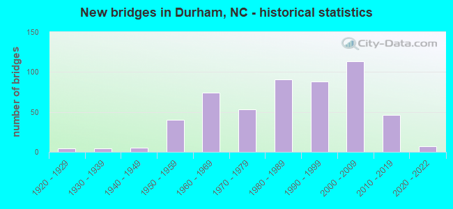
- New bridges - historical statistics
- 41920-1929
- 41930-1939
- 51940-1949
- 401950-1959
- 741960-1969
- 531970-1979
- 911980-1989
- 881990-1999
- 1132000-2009
- 462010-2019
- 72020-2022
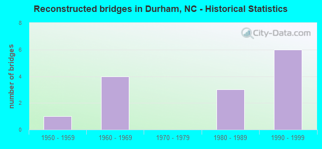
- Reconstructed bridges - Historical Statistics
- 11950-1959
- 41960-1969
- 01970-1979
- 31980-1989
- 61990-1999
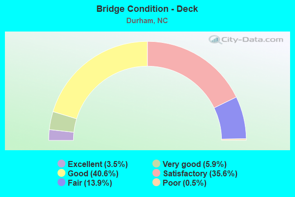
- Bridge Condition - Deck
- 3.5%Excellent
- 5.9%Very good
- 40.6%Good
- 35.6%Satisfactory
- 13.9%Fair
- 0.5%Poor
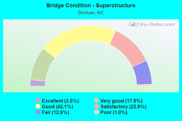
- Bridge Condition - Superstructure
- 3.5%Excellent
- 17.8%Very good
- 42.1%Good
- 22.8%Satisfactory
- 12.9%Fair
- 1.0%Poor
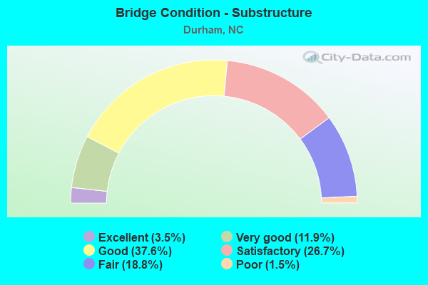
- Bridge Condition - Substructure
- 3.5%Excellent
- 11.9%Very good
- 37.6%Good
- 26.7%Satisfactory
- 18.8%Fair
- 1.5%Poor
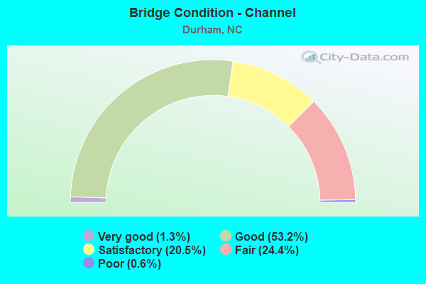
- Bridge Condition - Channel
- 1.3%Very good
- 53.2%Good
- 20.5%Satisfactory
- 24.4%Fair
- 0.6%Poor
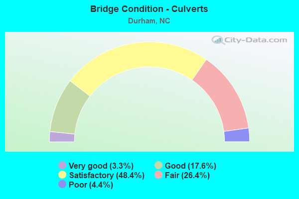
- Bridge Condition - Culverts
- 3.3%Very good
- 17.6%Good
- 48.4%Satisfactory
- 26.4%Fair
- 4.4%Poor
Find on map >> Show street view
Structure Number: 630573, Location: 0.1MI.W.JCT.MLK PARKWAY (Lat: 35.947439, Lng: -78.924556), Route carried "on" structure: City street , Year Built: 2009, Status: Open, Structure Length: 0.85m (2.79ft), Average Daily Traffic: 8,500 (year 2017), Truck Traffic: 7%, Average Future Daily Traffic: 17,000 (year 2040), Design Load: HS 20, Features Intersected: THIRD FORK CRK.TRIBUTARY, Facility Carried by Structure: SOUTH ROXBORO ST.
Minimum Vertical Clearance: 30+ m (98+ ft), Kilometerpoint: 0.000, Lanes on structure: 4, Owner: City or Municipal Highway Agency, Approaching Roadway Width: 22.8m (74.8ft), Skew: 22 degrees, Material/Design: Concrete continuous, Design/Construction: Culvert, Number Of Spans In Main Unit: 3, Length of Maximum Span: 2.4m (7.9ft)
Condition: Channel: Good, Culverts: Good, Operating Rating: 41.7 metric tons, Method Used To Determine Operating Rating: Field evaluation and documented engineering judgment, Inventory Rating: 32.6 metric tons, Method Used To Determine Inventory Rating: Field evaluation and documented engineering judgment, Structural Evaluation: Better than present minimum criteria, Waterway Adequacy: Better than present minimum criteria, Approach Roadway Alignment: Equal to present desirable criteria, Designated Inspection Frequency: Every 24 months, Inspection Date: January 2022
Find on map >> Show street view
Structure Number: 630579, Location: 0.4MI.W.JCT.S.ROXBORO ST. (Lat: 35.951444, Lng: -78.927242), Route carried "on" structure: City street , Year Built: 2009, Status: Open, Structure Length: 13.01m (42.68ft), Average Daily Traffic: 27,000 (year 2018), Truck Traffic: 7%, Average Future Daily Traffic: 54,000 (year 2040), Design Load: HS 20, Features Intersected: THIRD FORK CREEK, Facility Carried by Structure: MLK PARKWAY
Minimum Vertical Clearance: 30+ m (98+ ft), Kilometerpoint: 0.000, Lanes on structure: 4, Owner: City or Municipal Highway Agency, Approaching Roadway Width: 21.9m (71.9ft), Skew: 20 degrees, Material/Design: Prestressed concrete, Design/Construction: Stringer/Multi-beam, Number Of Spans In Main Unit: 5, Length of Maximum Span: 25.2m (82.7ft), Curb or Sidewalk Widths: Left: 1.5m (4.9ft), Right: 1.5m (4.9ft), Curb-To-Curb Width: 19.9m (65.3ft), Out-to-Out Width: 25.0m (82.0ft)
Condition: Deck: Good, Superstructure: Very good, Substructure: Good, Channel: Good, Operating Rating: 68.0 metric tons, Method Used To Determine Operating Rating: Load and Resistance Factor (LRFR), Inventory Rating: 51.7 metric tons, Method Used To Determine Inventory Rating: Load and Resistance Factor (LRFR), Structural Evaluation: Better than present minimum criteria, Deck Geometry: High priority of corrective action, Waterway Adequacy: Better than present minimum criteria, Approach Roadway Alignment: Equal to present desirable criteria, Designated Inspection Frequency: Every 24 months, Inspection Date: January 2022, Deck Structure Type: Concrete Cast-file-Place, Wearing Surface/Protective System: Wearing Surface: Monolithic Concrete
Find on map >> Show street view
Structure Number: 63058, Location: 0.2MI.S.CAMDEN AVENUE (Lat: 36.023250, Lng: -78.858028), Route carried "on" structure: City street , Year Built: 2009, Status: Open, Structure Length: 0.85m (2.79ft), Average Daily Traffic: 1,050 (year 2015), Truck Traffic: 7%, Average Future Daily Traffic: 2,100 (year 2040), Design Load: HS 20, Features Intersected: GOOSE CREEK, Facility Carried by Structure: MIST LAKE DRIVE
Minimum Vertical Clearance: 30+ m (98+ ft), Kilometerpoint: 0.000, Lanes on structure: 2, Owner: City or Municipal Highway Agency, Approaching Roadway Width: 6.0m (19.7ft), Material/Design: Steel, Design/Construction: Culvert, Number Of Spans In Main Unit: 3, Length of Maximum Span: 2.1m (6.9ft)
Condition: Channel: Good, Culverts: Satisfactory, Operating Rating: 89.8 metric tons, Method Used To Determine Operating Rating: Load and Resistance Factor (LRFR), Inventory Rating: 89.8 metric tons, Method Used To Determine Inventory Rating: Load and Resistance Factor (LRFR), Structural Evaluation: Equal to present minimum criteria, Waterway Adequacy: Better than present minimum criteria, Approach Roadway Alignment: Equal to present desirable criteria, Designated Inspection Frequency: Every 24 months, Inspection Date: January 2022
Find on map >> Show street view
Structure Number: 630581, Location: .1MI.E.JCT.BERMUDA GREEN (Lat: 35.982969, Lng: -78.805942), Route carried "on" structure: City street , Year Built: 2009, Status: Open, Structure Length: 1.37m (4.49ft), Average Daily Traffic: 1,500 (year 2007), Truck Traffic: 7%, Average Future Daily Traffic: 3,000 (year 2040), Design Load: HS 20, Features Intersected: LITTLE LICK CREEK TRIB., Facility Carried by Structure: OAK GROVE PARKWAY
Minimum Vertical Clearance: 30+ m (98+ ft), Kilometerpoint: 0.000, Lanes on structure: 2, Owner: City or Municipal Highway Agency, Approaching Roadway Width: 10.3m (33.8ft), Skew: 2 degrees, Material/Design: Concrete, Design/Construction: Culvert, Number Of Spans In Main Unit: 3, Length of Maximum Span: 3.9m (12.8ft)
Condition: Channel: Good, Culverts: Good, Operating Rating: 41.7 metric tons, Method Used To Determine Operating Rating: Field evaluation and documented engineering judgment, Inventory Rating: 32.6 metric tons, Method Used To Determine Inventory Rating: Field evaluation and documented engineering judgment, Structural Evaluation: Better than present minimum criteria, Waterway Adequacy: Better than present minimum criteria, Approach Roadway Alignment: Equal to present desirable criteria, Designated Inspection Frequency: Every 24 months, Inspection Date: January 2022
Find on map >> Show street view
Structure Number: 630582, Location: .1MI.E.JCT.HILLANDALE RD. (Lat: 36.057375, Lng: -78.935311), Route carried "on" structure: City street , Year Built: 2009, Status: Open, Structure Length: 1.00m (3.28ft), Average Daily Traffic: 7,600 (year 2017), Truck Traffic: 7%, Average Future Daily Traffic: 15,200 (year 2040), Design Load: HS 20, Features Intersected: WARREN CRK.TRIBUTARY B, Facility Carried by Structure: HORTON ROAD
Minimum Vertical Clearance: 30+ m (98+ ft), Kilometerpoint: 0.000, Lanes on structure: 2, Owner: City or Municipal Highway Agency, Approaching Roadway Width: 10.0m (32.8ft), Material/Design: Aluminum, Iron, Design/Construction: Culvert, Number Of Spans In Main Unit: 3, Length of Maximum Span: 3.0m (9.8ft)
Condition: Channel: Good, Culverts: Good, Operating Rating: 89.8 metric tons, Method Used To Determine Operating Rating: Load and Resistance Factor (LRFR), Inventory Rating: 89.8 metric tons, Method Used To Determine Inventory Rating: Load and Resistance Factor (LRFR), Structural Evaluation: Better than present minimum criteria, Waterway Adequacy: Better than present minimum criteria, Approach Roadway Alignment: Equal to present desirable criteria, Designated Inspection Frequency: Every 24 months, Inspection Date: January 2022
Find on map >> Show street view
Structure Number: 630583, Location: 0.1MI.S.JCT.IVY CRK. BLVD (Lat: 35.957725, Lng: -78.966033), Route carried "on" structure: City street , Year Built: 2009, Status: Open, Structure Length: 1.34m (4.40ft), Average Daily Traffic: 19,000 (year 2017), Truck Traffic: 7%, Average Future Daily Traffic: 38,000 (year 2040), Design Load: HS 20, Features Intersected: SANDY CRK.TRIBUTARY A, Facility Carried by Structure: UNIVERSITY DR.EXT.
Minimum Vertical Clearance: 30+ m (98+ ft), Kilometerpoint: 0.000, Lanes on structure: 4, Owner: City or Municipal Highway Agency, Approaching Roadway Width: 15.8m (51.8ft), Skew: 22 degrees, Material/Design: Steel, Design/Construction: Culvert, Number Of Spans In Main Unit: 3, Length of Maximum Span: 3.3m (10.8ft)
Condition: Channel: Good, Culverts: Good, Operating Rating: 89.8 metric tons, Method Used To Determine Operating Rating: Load and Resistance Factor (LRFR), Inventory Rating: 89.8 metric tons, Method Used To Determine Inventory Rating: Load and Resistance Factor (LRFR), Structural Evaluation: Better than present minimum criteria, Waterway Adequacy: Equal to present desirable criteria, Approach Roadway Alignment: Equal to present desirable criteria, Designated Inspection Frequency: Every 24 months, Inspection Date: January 2022
Find on map >> Show street view
Structure Number: 630584, Location: 0.1MI.E.JCT.N.DUKE STREET (Lat: 36.009883, Lng: -78.902767), Route carried "on" structure: City street , Year Built: 2011, Status: Open, Structure Length: 1.09m (3.58ft), Average Daily Traffic: 1,000 (year 2007), Truck Traffic: 7%, Average Future Daily Traffic: 2,000 (year 2040), Design Load: HS 20, Features Intersected: S.ELLERBEE CRK.TRIBUTAR, Facility Carried by Structure: W. MARKHAM AVE.
Minimum Vertical Clearance: 30+ m (98+ ft), Kilometerpoint: 0.000, Lanes on structure: 2, Owner: City or Municipal Highway Agency, Approaching Roadway Width: 9.1m (29.9ft), Skew: 3 degrees, Material/Design: Concrete continuous, Design/Construction: Culvert, Number Of Spans In Main Unit: 3, Length of Maximum Span: 2.7m (8.9ft)
Condition: Channel: Good, Culverts: Satisfactory, Operating Rating: 89.8 metric tons, Method Used To Determine Operating Rating: Load and Resistance Factor (LRFR), Inventory Rating: 79.8 metric tons, Method Used To Determine Inventory Rating: Load and Resistance Factor (LRFR), Structural Evaluation: Equal to present minimum criteria, Waterway Adequacy: Better than present minimum criteria, Approach Roadway Alignment: Equal to present desirable criteria, Designated Inspection Frequency: Every 24 months, Inspection Date: January 2022
Find on map >> Show street view
Structure Number: 630585, Location: .05MI.E.JCT.RUFFIN STREET (Lat: 36.012883, Lng: -78.901761), Route carried "on" structure: City street , Year Built: 1940, Status: Open, Structure Length: 0.79m (2.59ft), Average Daily Traffic: 1,600 (year 2007), Truck Traffic: 7%, Average Future Daily Traffic: 3,200 (year 2040), Design Load: HS 20, Features Intersected: S.ELLERBEE CRK.TRIBUTARY, Facility Carried by Structure: WEST KNOX STREET
Minimum Vertical Clearance: 30+ m (98+ ft), Kilometerpoint: 0.000, Lanes on structure: 2, Owner: City or Municipal Highway Agency, Approaching Roadway Width: 9.4m (30.8ft), Material/Design: Concrete continuous, Design/Construction: Culvert, Length of Maximum Span: 3.9m (12.8ft), Curb or Sidewalk Widths: Left: 0.0m, Right: 3.0m (9.8ft)
Condition: Channel: Fair, Culverts: Fair, Operating Rating: 41.7 metric tons, Method Used To Determine Operating Rating: Field evaluation and documented engineering judgment, Inventory Rating: 32.6 metric tons, Method Used To Determine Inventory Rating: Field evaluation and documented engineering judgment, Structural Evaluation: Somewhat better than minimum adequacy, Waterway Adequacy: Somewhat better than minimum adequacy, Approach Roadway Alignment: Equal to present desirable criteria, Designated Inspection Frequency: Every 24 months, Inspection Date: January 2022
Find on map >> Show street view
Structure Number: 630589, Location: .22 MI. W. JCT SR1999 (Lat: 35.876664, Lng: -78.866581), Route carried "on" structure: State highway 1978, Year Built: 2011, Status: Open, Structure Length: 4.75m (15.58ft), Average Daily Traffic: 14,500 (year 2019), Truck Traffic: 7%, Average Future Daily Traffic: 29,000 (year 2040), Design Load: HL 93, Features Intersected: NC147 EXT.
Minimum Vertical Clearance: 30+ m (98+ ft), Kilometerpoint: 0.000, Lanes on structure: 6, Lanes under structure: 6, Owner: State Highway Agency, Approaching Roadway Width: 25.2m (82.7ft), Material/Design: Prestressed concrete continuous, Design/Construction: Stringer/Multi-beam, Number Of Spans In Main Unit: 2, Number Of Approach Spans: 2, Length of Maximum Span: 22.8m (74.8ft), Curb or Sidewalk Widths: Left: 1.7m (5.6ft), Right: 1.7m (5.6ft), Curb-To-Curb Width: 25.6m (84.0ft), Out-to-Out Width: 29.8m (97.8ft)
Condition: Deck: Good, Superstructure: Very good, Substructure: Very good, Operating Rating: 78.0 metric tons, Method Used To Determine Operating Rating: Load and Resistance Factor (LRFR), Inventory Rating: 53.5 metric tons, Method Used To Determine Inventory Rating: Load and Resistance Factor (LRFR), Structural Evaluation: Equal to present desirable criteria, Deck Geometry: Somewhat better than minimum adequacy, Underclear: Somewhat better than minimum adequacy, Approach Roadway Alignment: Equal to present desirable criteria, Designated Inspection Frequency: Every 24 months, Inspection Date: September 2021, Deck Structure Type: Concrete Cast-file-Place, Wearing Surface/Protective System: Wearing Surface: Monolithic Concrete, Deck Protection: Epoxy Coated Reinforcing
Find on map >> Show street view
Structure Number: 63059, Location: 0.7 MI.S.JCT. I-40 (Lat: 35.891706, Lng: -78.873867), Route carried "on" structure: State highway 147, Year Built: 2011, Status: Open, Structure Length: 10.36m (33.99ft), Average Daily Traffic: 7,500 (year 2017), Truck Traffic: 12%, Average Future Daily Traffic: 15,000 (year 2040), Design Load: HL 93, Features Intersected: BURDENS CREEK
Minimum Vertical Clearance: 30+ m (98+ ft), Kilometerpoint: 0.000, Lanes on structure: 3, Base Highway Network: Yes (Inventory Route: 3, Subroute: 47), Toll: On toll road, Owner: State Toll Authority, Approaching Roadway Width: 18.8m (61.7ft), Skew: 11 degrees, Material/Design: Prestressed concrete continuous, Design/Construction: Stringer/Multi-beam, Number Of Spans In Main Unit: 4, Length of Maximum Span: 31.3m (102.7ft), Curb-To-Curb Width: 18.1m (59.4ft), Out-to-Out Width: 19.2m (63.0ft)
Condition: Deck: Satisfactory, Superstructure: Good, Substructure: Good, Channel: Satisfactory, Operating Rating: 65.3 metric tons, Method Used To Determine Operating Rating: Load and Resistance Factor (LRFR), Inventory Rating: 50.8 metric tons, Method Used To Determine Inventory Rating: Load and Resistance Factor (LRFR), Structural Evaluation: Better than present minimum criteria, Deck Geometry: Better than present minimum criteria, Waterway Adequacy: Better than present minimum criteria, Approach Roadway Alignment: Equal to present desirable criteria, Designated Inspection Frequency: Every 24 months, Inspection Date: July 2020, Deck Structure Type: Concrete Cast-file-Place, Wearing Surface/Protective System: Wearing Surface: Monolithic Concrete, Deck Protection: Epoxy Coated Reinforcing
Find on map >> Show street view
Structure Number: 630591, Location: 0.7 MI.S. OF JCT.I-40 (Lat: 35.891769, Lng: -78.873597), Route carried "on" structure: State highway 147, Year Built: 2011, Status: Open, Structure Length: 10.36m (33.99ft), Average Daily Traffic: 3,800 (year 2013), Truck Traffic: 12%, Average Future Daily Traffic: 7,600 (year 2040), Design Load: HL 93, Features Intersected: BURDENS CREEK
Minimum Vertical Clearance: 30+ m (98+ ft), Kilometerpoint: 0.000, Lanes on structure: 3, Base Highway Network: Yes (Inventory Route: 3, Subroute: 47), Toll: On toll road, Owner: State Toll Authority, Approaching Roadway Width: 18.8m (61.7ft), Skew: 11 degrees, Material/Design: Prestressed concrete continuous, Design/Construction: Stringer/Multi-beam, Number Of Spans In Main Unit: 4, Length of Maximum Span: 31.3m (102.7ft), Curb-To-Curb Width: 18.1m (59.4ft), Out-to-Out Width: 19.2m (63.0ft)
Condition: Deck: Satisfactory, Superstructure: Good, Substructure: Satisfactory, Channel: Satisfactory, Operating Rating: 65.3 metric tons, Method Used To Determine Operating Rating: Load and Resistance Factor (LRFR), Inventory Rating: 50.8 metric tons, Method Used To Determine Inventory Rating: Load and Resistance Factor (LRFR), Structural Evaluation: Equal to present minimum criteria, Deck Geometry: Better than present minimum criteria, Waterway Adequacy: Better than present minimum criteria, Approach Roadway Alignment: Equal to present desirable criteria, Designated Inspection Frequency: Every 24 months, Inspection Date: July 2020, Deck Structure Type: Concrete Cast-file-Place, Wearing Surface/Protective System: Wearing Surface: Monolithic Concrete, Deck Protection: Epoxy Coated Reinforcing
Find on map >> Show street view
Structure Number: 630593, Location: 0.9 MI E. JCT SR1801 (Lat: 35.991242, Lng: -78.862644), Route carried "on" structure: US 70, Year Built: 2015, Status: Open, Structure Length: 4.05m (13.29ft), Average Daily Traffic: 65,700 (year 2015), Truck Traffic: 7%, Average Future Daily Traffic: 116,100 (year 2040), Design Load: HL 93, Features Intersected: NC98
Minimum Vertical Clearance: 30+ m (98+ ft), Kilometerpoint: 0.000, Lanes on structure: 5, Lanes under structure: 4, Owner: State Highway Agency, Approaching Roadway Width: 21.9m (71.9ft), Skew: 32 degrees, Material/Design: Prestressed concrete, Design/Construction: Stringer/Multi-beam, Number Of Spans In Main Unit: 1, Number Of Approach Spans: 2, Length of Maximum Span: 39.0m (128.0ft), Curb-To-Curb Width: 43.8m (143.7ft), Out-to-Out Width: 45.4m (149.0ft)
Condition: Deck: Very good, Superstructure: Very good, Substructure: Very good, Operating Rating: 89.8 metric tons, Method Used To Determine Operating Rating: Load and Resistance Factor (LRFR), Inventory Rating: 75.2 metric tons, Method Used To Determine Inventory Rating: Load and Resistance Factor (LRFR), Structural Evaluation: Equal to present desirable criteria, Deck Geometry: Superior to present desirable criteria, Underclear: Superior to present desirable criteria, Approach Roadway Alignment: Equal to present desirable criteria, Designated Inspection Frequency: Every 24 months, Inspection Date: April 2021, Deck Structure Type: Concrete Cast-file-Place, Wearing Surface/Protective System: Wearing Surface: Monolithic Concrete, Deck Protection: Epoxy Coated Reinforcing
Find on map >> Show street view
Structure Number: 630594, Location: .10 MI.W.JCT. N.HOOVER RD (Lat: 35.981058, Lng: -78.857050), Route carried "on" structure: City street , Year Built: 2020, Status: Open, Structure Length: 8.22m (26.97ft), Average Daily Traffic: 58,050 (year 2018), Truck Traffic: 7%, Average Future Daily Traffic: 116,100 (year 2040), Design Load: HL 93, Features Intersected: US70, Facility Carried by Structure: CARR ROAD
Minimum Vertical Clearance: 30+ m (98+ ft), Kilometerpoint: 0.000, Lanes on structure: 2, Lanes under structure: 5, Owner: City or Municipal Highway Agency, Approaching Roadway Width: 14.6m (47.9ft), Skew: 1 degrees, Material/Design: Prestressed concrete, Design/Construction: Stringer/Multi-beam, Number Of Spans In Main Unit: 2, Number Of Approach Spans: 2, Length of Maximum Span: 42.6m (139.8ft), Curb or Sidewalk Widths: Left: 1.6m (5.2ft), Right: 1.6m (5.2ft), Curb-To-Curb Width: 10.9m (35.8ft), Out-to-Out Width: 15.1m (49.5ft)
Condition: Deck: Very good, Superstructure: Very good, Substructure: Very good, Operating Rating: 59.8 metric tons, Method Used To Determine Operating Rating: Load and Resistance Factor (LRFR), Inventory Rating: 46.2 metric tons, Method Used To Determine Inventory Rating: Load and Resistance Factor (LRFR), Structural Evaluation: Equal to present desirable criteria, Deck Geometry: Meets minimum limits, Underclear: High priority of corrective action, Approach Roadway Alignment: Equal to present desirable criteria, Designated Inspection Frequency: Every 24 months, Inspection Date: April 2021, Deck Structure Type: Concrete Cast-file-Place, Wearing Surface/Protective System: Wearing Surface: Monolithic Concrete, Deck Protection: Epoxy Coated Reinforcing
Find on map >> Show street view
Structure Number: 630595, Location: 0.5 MI W. JCT. SR1921 (Lat: 35.975389, Lng: -78.854750), Route carried "on" structure: US 70, Year Built: 2014, Status: Open, Structure Length: 8.22m (26.97ft), Average Daily Traffic: 100 (year 2015), Truck Traffic: 12%, Average Future Daily Traffic: 200 (year 2040), Design Load: HL 93, Features Intersected: EAST END CONNECTOR
Minimum Vertical Clearance: 30+ m (98+ ft), Kilometerpoint: 0.000, Lanes on structure: 3, Lanes under structure: 2, Owner: State Highway Agency, Approaching Roadway Width: 15.2m (49.9ft), Skew: 14 degrees, Material/Design: Steel, Design/Construction: Stringer/Multi-beam, Number Of Spans In Main Unit: 2, Length of Maximum Span: 41.4m (135.8ft), Curb-To-Curb Width: 15.2m (49.9ft), Out-to-Out Width: 16.2m (53.1ft)
Condition: Deck: Very good, Superstructure: Very good, Substructure: Very good, Operating Rating: 67.1 metric tons, Method Used To Determine Operating Rating: Load and Resistance Factor (LRFR), Inventory Rating: 51.7 metric tons, Method Used To Determine Inventory Rating: Load and Resistance Factor (LRFR), Structural Evaluation: Equal to present desirable criteria, Deck Geometry: Equal to present minimum criteria, Underclear: High priority of corrective action, Approach Roadway Alignment: Equal to present desirable criteria, Designated Inspection Frequency: Every 24 months, Inspection Date: April 2021, Deck Structure Type: Concrete Cast-file-Place
Find on map >> Show street view
Structure Number: 630596, Location: 0.8 MI. E. JCT. NC147 (Lat: 35.976167, Lng: -78.854139), Route carried "on" structure: Ramp US 70, Year Built: 2014, Status: Open, Structure Length: 16.67m (54.69ft), Average Daily Traffic: 65,700 (year 2015), Truck Traffic: 12%, Average Future Daily Traffic: 116,100 (year 2040), Design Load: HL 93, Features Intersected: US70
Minimum Vertical Clearance: 30+ m (98+ ft), Kilometerpoint: 0.000, Lanes on structure: 1, Lanes under structure: 7, Owner: State Highway Agency, Approaching Roadway Width: 12.4m (40.7ft), Material/Design: Steel, Design/Construction: Stringer/Multi-beam, Number Of Spans In Main Unit: 4, Length of Maximum Span: 49.6m (162.7ft), Curb-To-Curb Width: 11.5m (37.7ft), Out-to-Out Width: 12.5m (41.0ft)
Condition: Deck: Very good, Superstructure: Very good, Substructure: Very good, Operating Rating: 89.8 metric tons, Method Used To Determine Operating Rating: Load and Resistance Factor (LRFR), Inventory Rating: 71.6 metric tons, Method Used To Determine Inventory Rating: Load and Resistance Factor (LRFR), Structural Evaluation: Equal to present desirable criteria, Deck Geometry: Superior to present desirable criteria, Underclear: High priority of corrective action, Approach Roadway Alignment: Equal to present desirable criteria, Designated Inspection Frequency: Every 24 months, Inspection Date: April 2021, Deck Structure Type: Concrete Cast-file-Place
Find on map >> Show street view
Structure Number: 630597, Location: 0.6 MI. S. JCT. U.S. 70 (Lat: 35.971564, Lng: -78.858328), Route carried "on" structure: Interstate 885, Year Built: 2015, Status: Open, Structure Length: 4.17m (13.68ft), Average Daily Traffic: 65,700 (year 2015), Truck Traffic: 16%, Average Future Daily Traffic: 116,100 (year 2040), Design Load: HL 93, Features Intersected: ROWENA AVE.
Minimum Vertical Clearance: 30+ m (98+ ft), Kilometerpoint: 0.000, Lanes on structure: 3, Lanes under structure: 2, Base Highway Network: Yes (Inventory Route: 1, Subroute: 85), Owner: State Highway Agency, Approaching Roadway Width: 29.2m (95.8ft), Skew: 12 degrees, Material/Design: Steel, Design/Construction: Stringer/Multi-beam, Number Of Spans In Main Unit: 1, Length of Maximum Span: 40.2m (131.9ft), Curb-To-Curb Width: 21.9m (71.9ft), Out-to-Out Width: 22.9m (75.1ft)
Condition: Deck: Excellent, Superstructure: Excellent, Substructure: Excellent, Operating Rating: 68.9 metric tons, Method Used To Determine Operating Rating: Load and Resistance Factor (LRFR), Inventory Rating: 52.6 metric tons, Method Used To Determine Inventory Rating: Load and Resistance Factor (LRFR), Structural Evaluation: Superior to present desirable criteria, Deck Geometry: Superior to present desirable criteria, Underclear: Better than present minimum criteria, Approach Roadway Alignment: Equal to present desirable criteria, Designated Inspection Frequency: Every 24 months, Inspection Date: April 2021, Deck Structure Type: Concrete Cast-file-Place
Find on map >> Show street view
Structure Number: 630598, Location: 0.7 MI. N. JCT. NC.147 (Lat: 35.971361, Lng: -78.858258), Route carried "on" structure: Interstate 885, Year Built: 2015, Status: Open, Structure Length: 4.17m (13.68ft), Average Daily Traffic: 65,700 (year 2015), Truck Traffic: 16%, Average Future Daily Traffic: 116,100 (year 2035), Design Load: HL 93, Features Intersected: ROWENA AVE.
Minimum Vertical Clearance: 30+ m (98+ ft), Kilometerpoint: 0.000, Lanes on structure: 4, Lanes under structure: 2, Owner: State Highway Agency, Approaching Roadway Width: 29.2m (95.8ft), Skew: 12 degrees, Material/Design: Steel, Design/Construction: Stringer/Multi-beam, Number Of Spans In Main Unit: 1, Number Of Approach Spans: 2, Length of Maximum Span: 40.2m (131.9ft), Curb-To-Curb Width: 21.9m (71.9ft), Out-to-Out Width: 22.9m (75.1ft)
Condition: Deck: Excellent, Superstructure: Excellent, Substructure: Excellent, Operating Rating: 69.8 metric tons, Method Used To Determine Operating Rating: Load and Resistance Factor (LRFR), Inventory Rating: 53.5 metric tons, Method Used To Determine Inventory Rating: Load and Resistance Factor (LRFR), Structural Evaluation: Superior to present desirable criteria, Deck Geometry: Better than present minimum criteria, Underclear: Superior to present desirable criteria, Approach Roadway Alignment: Equal to present desirable criteria, Designated Inspection Frequency: Every 24 months, Inspection Date: April 2021, Deck Structure Type: Concrete Cast-file-Place, Wearing Surface/Protective System: Wearing Surface: Monolithic Concrete, Deck Protection: Epoxy Coated Reinforcing
Find on map >> Show street view
Structure Number: 630599, Location: 0.5 MI.S.JCT.US70 (Lat: 35.969203, Lng: -78.862006), Route carried "on" structure: Interstate 885, Year Built: 2021, Status: Open, Structure Length: 12.03m (39.47ft), Average Daily Traffic: 100 (year 2019), Truck Traffic: 16%, Average Future Daily Traffic: 200 (year 2040), Design Load: HL 93, Features Intersected: SR1926,NSRR
Minimum Vertical Clearance: 30+ m (98+ ft), Kilometerpoint: 0.000, Lanes on structure: 4, Lanes under structure: 4, Base Highway Network: Yes (Inventory Route: 1, Subroute: 85), Owner: State Highway Agency, Approaching Roadway Width: 30.1m (98.8ft), Skew: 10 degrees, Material/Design: Steel continuous, Design/Construction: Stringer/Multi-beam, Number Of Spans In Main Unit: 3, Length of Maximum Span: 56.6m (185.7ft), Curb-To-Curb Width: 22.4m (73.5ft), Out-to-Out Width: 23.3m (76.4ft)
Condition: Deck: Excellent, Superstructure: Excellent, Substructure: Excellent, Operating Rating: 73.4 metric tons, Method Used To Determine Operating Rating: Load and Resistance Factor (LRFR), Inventory Rating: 56.2 metric tons, Method Used To Determine Inventory Rating: Load and Resistance Factor (LRFR), Structural Evaluation: Superior to present desirable criteria, Deck Geometry: Superior to present desirable criteria, Underclear: High priority of corrective action, Approach Roadway Alignment: Equal to present desirable criteria, Designated Inspection Frequency: Every 24 months, Inspection Date: April 2021, Deck Structure Type: Concrete Cast-file-Place
Find on map >> Show street view
Structure Number: 6306, Location: 0.4 MI. N. JCT. NC147 (Lat: 35.969014, Lng: -78.861808), Route carried "on" structure: Interstate 885, Year Built: 2019, Status: Open, Structure Length: 12.03m (39.47ft), Average Daily Traffic: 37,750 (year 2019), Truck Traffic: 7%, Average Future Daily Traffic: 75,500 (year 2040), Design Load: HL 93, Features Intersected: SR1926
Minimum Vertical Clearance: 30.44m (99.87ft), Kilometerpoint: 0.000, Lanes on structure: 4, Lanes under structure: 2, Base Highway Network: Yes (Inventory Route: 1, Subroute: 85), Owner: State Highway Agency, Approaching Roadway Width: 30.1m (98.8ft), Material/Design: Prestressed concrete, Design/Construction: Stringer/Multi-beam, Length of Maximum Span: 56.6m (185.7ft), Curb-To-Curb Width: 22.4m (73.5ft), Out-to-Out Width: 23.3m (76.4ft)
Condition: Deck: Excellent, Superstructure: Excellent, Substructure: Excellent, Operating Rating: 73.4 metric tons, Method Used To Determine Operating Rating: Load and Resistance Factor (LRFR), Inventory Rating: 56.2 metric tons, Method Used To Determine Inventory Rating: Load and Resistance Factor (LRFR), Structural Evaluation: Superior to present desirable criteria, Deck Geometry: Superior to present desirable criteria, Underclear: High priority of corrective action, Approach Roadway Alignment: Equal to present desirable criteria, Designated Inspection Frequency: Every 24 months, Inspection Date: April 2021, Deck Structure Type: Concrete Cast-file-Place
Find on map >> Show street view
Structure Number: 630601, Location: 0.1 MI. N. JCT NC 147 (Lat: 35.965997, Lng: -78.865386), Route carried "on" structure: Ramp Interstate 885, Year Built: 2015, Status: Open, Structure Length: 27.92m (91.60ft), Average Daily Traffic: 65,700 (year 2015), Truck Traffic: 16%, Average Future Daily Traffic: 116,100 (year 2035), Design Load: HL 93, Features Intersected: I-885 & NC147
Minimum Vertical Clearance: 30+ m (98+ ft), Kilometerpoint: 0.000, Lanes on structure: 2, Lanes under structure: 6, Owner: State Highway Agency, Approaching Roadway Width: 15.8m (51.8ft), Material/Design: Steel continuous, Design/Construction: Stringer/Multi-beam, Number Of Spans In Main Unit: 6, Number Of Approach Spans: 2, Length of Maximum Span: 53.3m (174.9ft), Curb-To-Curb Width: 11.5m (37.7ft), Out-to-Out Width: 12.5m (41.0ft)
Condition: Deck: Excellent, Superstructure: Excellent, Substructure: Excellent, Operating Rating: 60.7 metric tons, Method Used To Determine Operating Rating: Load and Resistance Factor (LRFR), Inventory Rating: 47.1 metric tons, Method Used To Determine Inventory Rating: Load and Resistance Factor (LRFR), Structural Evaluation: Superior to present desirable criteria, Deck Geometry: Superior to present desirable criteria, Underclear: High priority of corrective action, Approach Roadway Alignment: Equal to present desirable criteria, Designated Inspection Frequency: Every 24 months, Inspection Date: April 2021, Deck Structure Type: Concrete Cast-file-Place
Find on map >> Show street view
Structure Number: 630602, Location: 1.2 MI. S. JCT. US70 (Lat: 35.965283, Lng: -78.865492), Route carried "on" structure: Ramp State highway 147, Year Built: 2019, Status: Open, Structure Length: 2.37m (7.78ft), Average Daily Traffic: 100 (year 2019), Truck Traffic: 12%, Average Future Daily Traffic: 200 (year 2040), Design Load: HL 93, Features Intersected: NC147N
Minimum Vertical Clearance: 30+ m (98+ ft), Kilometerpoint: 0.000, Lanes on structure: 2, Lanes under structure: 2, Owner: State Highway Agency, Approaching Roadway Width: 18.2m (59.7ft), Skew: 6 degrees, Material/Design: Prestressed concrete, Design/Construction: Stringer/Multi-beam, Number Of Spans In Main Unit: 1, Length of Maximum Span: 22.2m (72.8ft), Curb-To-Curb Width: 43.5m (142.7ft), Out-to-Out Width: 117.6m (385.8ft)
Condition: Deck: Excellent, Superstructure: Excellent, Substructure: Excellent, Operating Rating: 80.7 metric tons, Method Used To Determine Operating Rating: Load and Resistance Factor (LRFR), Inventory Rating: 62.5 metric tons, Method Used To Determine Inventory Rating: Load and Resistance Factor (LRFR), Structural Evaluation: Superior to present desirable criteria, Deck Geometry: Superior to present desirable criteria, Underclear: Equal to present minimum criteria, Approach Roadway Alignment: Equal to present desirable criteria, Designated Inspection Frequency: Every 24 months, Inspection Date: April 2021, Deck Structure Type: Concrete Cast-file-Place, Wearing Surface/Protective System: Wearing Surface: Monolithic Concrete, Deck Protection: Epoxy Coated Reinforcing
Find on map >> Show street view
Structure Number: 630632, Location: 0.2 MI. N. JCT. SR1656 (Lat: 36.062131, Lng: -78.876156), Route carried "on" structure: City street , Year Built: 2006, Status: Open, Structure Length: 0.76m (2.49ft), Average Daily Traffic: 100 (year 2015), Truck Traffic: 7%, Average Future Daily Traffic: 200 (year 2040), Design Load: HS 20, Features Intersected: CREEK, Facility Carried by Structure: MILLER DRIVE
Minimum Vertical Clearance: 30+ m (98+ ft), Kilometerpoint: 0.000, Lanes on structure: 2, Owner: City or Municipal Highway Agency, Approaching Roadway Width: 10.0m (32.8ft), Skew: 2 degrees, Material/Design: Aluminum, Iron, Design/Construction: Culvert, Number Of Spans In Main Unit: 1, Length of Maximum Span: 7.6m (24.9ft)
Condition: Channel: Good, Culverts: Very good, Operating Rating: 89.8 metric tons, Method Used To Determine Operating Rating: Load and Resistance Factor (LRFR), Inventory Rating: 89.8 metric tons, Method Used To Determine Inventory Rating: Load and Resistance Factor (LRFR), Structural Evaluation: Equal to present desirable criteria, Waterway Adequacy: Better than present minimum criteria, Approach Roadway Alignment: Equal to present desirable criteria, Designated Inspection Frequency: Every 24 months, Inspection Date: January 2022
Find on map >> Show street view
Structure Number: 630633, Location: 0.5 M. N. OF SWANNS MILL (Lat: 36.063081, Lng: -78.876117), Route carried "on" structure: City street , Year Built: 2006, Status: Open, Structure Length: 0.76m (2.49ft), Average Daily Traffic: 100 (year 2015), Truck Traffic: 7%, Average Future Daily Traffic: 200 (year 2040), Design Load: HS 20, Features Intersected: CREEK, Facility Carried by Structure: MILLER DRIVE
Minimum Vertical Clearance: 30+ m (98+ ft), Kilometerpoint: 0.000, Lanes on structure: 2, Owner: City or Municipal Highway Agency, Approaching Roadway Width: 10.0m (32.8ft), Material/Design: Aluminum, Iron, Design/Construction: Culvert, Number Of Spans In Main Unit: 1, Length of Maximum Span: 7.6m (24.9ft)
Condition: Channel: Satisfactory, Culverts: Very good, Operating Rating: 89.8 metric tons, Method Used To Determine Operating Rating: Load and Resistance Factor (LRFR), Inventory Rating: 89.8 metric tons, Method Used To Determine Inventory Rating: Load and Resistance Factor (LRFR), Structural Evaluation: Equal to present desirable criteria, Waterway Adequacy: Better than present minimum criteria, Approach Roadway Alignment: Equal to present desirable criteria, Designated Inspection Frequency: Every 24 months, Inspection Date: January 2022
Find on map >> Show street view
Structure Number: 630636, Location: .37 M EAST OF SHERRON RD (Lat: 35.949375, Lng: -78.827183), Route carried "on" structure: City street , Year Built: 2004, Status: Open, Structure Length: 0.91m (2.99ft), Average Daily Traffic: 101 (year 2017), Truck Traffic: 7%, Average Future Daily Traffic: 200 (year 2040), Design Load: HS 20, Features Intersected: LICK CREEK, Facility Carried by Structure: GOLDEN BELT PKWY.
Minimum Vertical Clearance: 30+ m (98+ ft), Kilometerpoint: 0.000, Lanes on structure: 2, Owner: City or Municipal Highway Agency, Approaching Roadway Width: 12.4m (40.7ft), Skew: 3 degrees, Material/Design: Aluminum, Iron, Design/Construction: Culvert, Number Of Spans In Main Unit: 3, Length of Maximum Span: 2.1m (6.9ft)
Condition: Channel: Good, Culverts: Very good, Operating Rating: 89.8 metric tons, Method Used To Determine Operating Rating: Load and Resistance Factor (LRFR), Inventory Rating: 89.8 metric tons, Method Used To Determine Inventory Rating: Load and Resistance Factor (LRFR), Structural Evaluation: Equal to present desirable criteria, Waterway Adequacy: Better than present minimum criteria, Approach Roadway Alignment: Equal to present desirable criteria, Designated Inspection Frequency: Every 24 months, Inspection Date: January 2022
Find on map >> Show street view
Structure Number: 630637, Location: .9 M S FLETCHERS CHAPEL D (Lat: 36.002811, Lng: -78.811803), Route carried "on" structure: City street , Year Built: 2018, Status: Open, Structure Length: 2.46m (8.07ft), Average Daily Traffic: 101 (year 2017), Truck Traffic: 7%, Average Future Daily Traffic: 200 (year 2040), Design Load: HS 20, Features Intersected: CHUNKY PIPE CREEK, Facility Carried by Structure: PEBBLESTONE DRIVE
Minimum Vertical Clearance: 30+ m (98+ ft), Kilometerpoint: 0.000, Lanes on structure: 2, Owner: City or Municipal Highway Agency, Approaching Roadway Width: 8.2m (26.9ft), Material/Design: Concrete, Design/Construction: Culvert, Number Of Spans In Main Unit: 2, Length of Maximum Span: 9.7m (31.8ft)
Condition: Channel: Good, Culverts: Good, Operating Rating: 41.7 metric tons, Method Used To Determine Operating Rating: Field evaluation and documented engineering judgment, Inventory Rating: 32.6 metric tons, Method Used To Determine Inventory Rating: Field evaluation and documented engineering judgment, Structural Evaluation: Better than present minimum criteria, Waterway Adequacy: Better than present minimum criteria, Approach Roadway Alignment: Equal to present desirable criteria, Designated Inspection Frequency: Every 24 months, Inspection Date: January 2022
Find on map >> Show street view
Structure Number: 630639, Location: .06 M E. BLACK BOULDER TR (Lat: 36.090583, Lng: -78.927722), Route carried "on" structure: City street , Year Built: 2002, Status: Open, Structure Length: 0.91m (2.99ft), Average Daily Traffic: 101 (year 2017), Truck Traffic: 7%, Average Future Daily Traffic: 200 (year 2040), Design Load: HS 20, Features Intersected: CROOKED CREEK, Facility Carried by Structure: PACES FERRY DRIVE
Minimum Vertical Clearance: 30+ m (98+ ft), Kilometerpoint: 0.000, Lanes on structure: 2, Owner: City or Municipal Highway Agency, Approaching Roadway Width: 8.8m (28.9ft), Skew: 1 degrees, Material/Design: Aluminum, Iron, Design/Construction: Culvert, Number Of Spans In Main Unit: 2, Length of Maximum Span: 3.9m (12.8ft)
Condition: Channel: Good, Culverts: Good, Operating Rating: 55.3 metric tons, Method Used To Determine Operating Rating: Load and Resistance Factor (LRFR), Inventory Rating: 49.8 metric tons, Method Used To Determine Inventory Rating: Load and Resistance Factor (LRFR), Structural Evaluation: Better than present minimum criteria, Waterway Adequacy: Better than present minimum criteria, Approach Roadway Alignment: Equal to present desirable criteria, Designated Inspection Frequency: Every 24 months, Inspection Date: January 2022
Find on map >> Show street view
Structure Number: 630641, Location: 0.11 MI. E. JCT. SR1110 (Lat: 35.943306, Lng: -78.981361), Route carried "on" structure: State highway 2220, Year Built: 2018, Status: Open, Structure Length: 0.88m (2.89ft), Average Daily Traffic: 16,000 (year 2018), Truck Traffic: 6%, Average Future Daily Traffic: 32,000 (year 2040), Design Load: HL 93, Features Intersected: NEW HOPE CREEK
Minimum Vertical Clearance: 30+ m (98+ ft), Kilometerpoint: 0.000, Lanes on structure: 3, Owner: State Highway Agency, Approaching Roadway Width: 13.7m (44.9ft), Skew: 3 degrees, Material/Design: Concrete continuous, Design/Construction: Culvert, Length of Maximum Span: 3.0m (9.8ft)
Condition: Channel: Fair, Culverts: Good, Operating Rating: 46.2 metric tons, Method Used To Determine Operating Rating: Load and Resistance Factor (LRFR), Inventory Rating: 35.3 metric tons, Method Used To Determine Inventory Rating: Load and Resistance Factor (LRFR), Structural Evaluation: Better than present minimum criteria, Waterway Adequacy: Better than present minimum criteria, Approach Roadway Alignment: Equal to present desirable criteria, Designated Inspection Frequency: Every 24 months, Inspection Date: June 2021
Find on map >> Show street view
Structure Number: 135001, Location: 0.2 MI. S. JCT. SR1913 (Lat: 35.881811, Lng: -79.061453), Route carried "on" structure: US 15, Year Built: 2003, Status: Open, Structure Length: 1.31m (4.30ft), Average Daily Traffic: 25,000 (year 2017), Truck Traffic: 12%, Average Future Daily Traffic: 50,000 (year 2040), Design Load: HS 20+Mod, Features Intersected: OBIE'S CREEK
Minimum Vertical Clearance: 30+ m (98+ ft), Kilometerpoint: 0.000, Lanes on structure: 2, Base Highway Network: Yes (Inventory Route: 2, Subroute: 15), Owner: State Highway Agency, Approaching Roadway Width: 21.3m (69.9ft), Skew: 25 degrees, Material/Design: Concrete continuous, Design/Construction: Culvert, Number Of Spans In Main Unit: 2, Length of Maximum Span: 3.6m (11.8ft)
Condition: Channel: Fair, Culverts: Fair, Operating Rating: 34.4 metric tons, Method Used To Determine Operating Rating: Field evaluation and documented engineering judgment, Inventory Rating: 26.3 metric tons, Method Used To Determine Inventory Rating: Field evaluation and documented engineering judgment, Structural Evaluation: Somewhat better than minimum adequacy, Waterway Adequacy: Better than present minimum criteria, Approach Roadway Alignment: Equal to present desirable criteria, Designated Inspection Frequency: Every 24 months, Inspection Date: January 2021
Find on map >> Show street view
Structure Number: 1350016, Location: 0.2 MI. S. JCT. US70 (Lat: 36.029658, Lng: -78.988967), Route carried "on" structure: State highway 751, Year Built: 1930, Status: Open, Structure Length: 3.87m (12.70ft), Average Daily Traffic: 4,800 (year 2017), Truck Traffic: 6%, Average Future Daily Traffic: 9,600 (year 2040), Design Load: H 15, Features Intersected: SOUTHERN R.R.
Minimum Vertical Clearance: 30+ m (98+ ft), Kilometerpoint: 0.000, Lanes on structure: 2, Owner: State Highway Agency, Approaching Roadway Width: 7.3m (24.0ft), Material/Design: Concrete, Design/Construction: Tee Beam, Number Of Spans In Main Unit: 3, Length of Maximum Span: 12.4m (40.7ft), Curb or Sidewalk Widths: Left: 0.2m (0.7ft), Right: 0.2m (0.7ft), Curb-To-Curb Width: 5.9m (19.4ft), Out-to-Out Width: 6.5m (21.3ft)
Condition: Deck: Fair, Superstructure: Fair, Substructure: Fair, Operating Rating: 33.5 metric tons, Method Used To Determine Operating Rating: Load Factor (LF), Inventory Rating: 19.9 metric tons, Method Used To Determine Inventory Rating: Load Factor (LF), Structural Evaluation: Somewhat better than minimum adequacy, Deck Geometry: High priority of replacement, Underclear: Meets minimum limits, Approach Roadway Alignment: Equal to present desirable criteria, Designated Inspection Frequency: Every 24 months, Inspection Date: Febuary 2022, Deck Structure Type: Concrete Cast-file-Place, Wearing Surface/Protective System: Wearing Surface: Bituminous
Find on map >> Show street view
Structure Number: 1350056, Location: 0.4 MI. W. JCT. I-85 (Lat: 36.044714, Lng: -79.020122), Route carried "on" structure: US 70, Year Built: 1948, Status: Open, Structure Length: 1.15m (3.77ft), Average Daily Traffic: 13,000 (year 2018), Truck Traffic: 6%, Average Future Daily Traffic: 26,000 (year 2040), Design Load: HS 20, Features Intersected: STONY CREEK
Minimum Vertical Clearance: 30+ m (98+ ft), Kilometerpoint: 0.000, Lanes on structure: 2, Owner: State Highway Agency, Approaching Roadway Width: 7.3m (24.0ft), Material/Design: Concrete, Design/Construction: Culvert, Number Of Spans In Main Unit: 1, Length of Maximum Span: 11.5m (37.7ft)
Condition: Channel: Fair, Culverts: Fair, Operating Rating: 41.7 metric tons, Method Used To Determine Operating Rating: Field evaluation and documented engineering judgment, Inventory Rating: 32.6 metric tons, Method Used To Determine Inventory Rating: Field evaluation and documented engineering judgment, Structural Evaluation: Somewhat better than minimum adequacy, Waterway Adequacy: Better than present minimum criteria, Approach Roadway Alignment: Equal to present desirable criteria, Designated Inspection Frequency: Every 24 months, Inspection Date: December 2021
Find on map >> Show street view
Structure Number: 1350063, Location: 0.4 MI. N. JCT. US70 (Lat: 36.046631, Lng: -79.010711), Route carried "on" structure: State highway 1567, Year Built: 1958, Status: Open, Structure Length: 6.24m (20.47ft), Average Daily Traffic: 3,900 (year 2017), Truck Traffic: 7%, Average Future Daily Traffic: 7,800 (year 2040), Design Load: H 20, Features Intersected: ENO RIVER
Minimum Vertical Clearance: 30+ m (98+ ft), Kilometerpoint: 0.000, Lanes on structure: 2, Owner: State Highway Agency, Approaching Roadway Width: 7.0m (23.0ft), Skew: 3 degrees, Material/Design: Concrete, Design/Construction: Tee Beam, Number Of Spans In Main Unit: 6, Length of Maximum Span: 16.4m (53.8ft), Curb or Sidewalk Widths: Left: 0.4m (1.3ft), Right: 0.4m (1.3ft), Curb-To-Curb Width: 7.1m (23.3ft), Out-to-Out Width: 8.6m (28.2ft)
Condition: Deck: Satisfactory, Superstructure: Satisfactory, Substructure: Fair, Channel: Good, Operating Rating: 29.0 metric tons, Method Used To Determine Operating Rating: Field evaluation and documented engineering judgment, Inventory Rating: 21.7 metric tons, Method Used To Determine Inventory Rating: Field evaluation and documented engineering judgment, Structural Evaluation: Somewhat better than minimum adequacy, Deck Geometry: High priority of replacement, Waterway Adequacy: Better than present minimum criteria, Approach Roadway Alignment: Equal to present desirable criteria, Designated Inspection Frequency: Every 24 months, Inspection Date: May 2020, Deck Structure Type: Concrete Cast-file-Place, Wearing Surface/Protective System: Wearing Surface: Monolithic Concrete
Find on map >> Show street view
Structure Number: 135009, Location: 0.2 MI. N. JCT. SR1939 (Lat: 35.870381, Lng: -79.116989), Route carried "on" structure: State highway 1940, Year Built: 1955, Status: Posted for load, Structure Length: 1.12m (3.67ft), Average Daily Traffic: 1,600 (year 2016), Truck Traffic: 6%, Average Future Daily Traffic: 3,200 (year 2040), Features Intersected: PRITCHARD MILL CREEK
Minimum Vertical Clearance: 30+ m (98+ ft), Kilometerpoint: 0.000, Lanes on structure: 2, Owner: State Highway Agency, Approaching Roadway Width: 6.0m (19.7ft), Material/Design: Steel, Design/Construction: Stringer/Multi-beam, Number Of Spans In Main Unit: 1, Length of Maximum Span: 10.9m (35.8ft), Curb-To-Curb Width: 6.7m (22.0ft), Out-to-Out Width: 7.0m (23.0ft)
Condition: Deck: Fair, Superstructure: Fair, Substructure: Fair, Channel: Fair, Operating Rating: 21.7 metric tons, Method Used To Determine Operating Rating: Load Factor (LF), Inventory Rating: 12.7 metric tons, Method Used To Determine Inventory Rating: Load Factor (LF), Structural Evaluation: Meets minimum limits, Deck Geometry: High priority of corrective action, Waterway Adequacy: Better than present minimum criteria, Approach Roadway Alignment: Equal to present desirable criteria, Bridge Posting: Required (Relationship of Operating Rating to Maximum Legal Load: > 39.9% below), Designated Inspection Frequency: Every 24 months, Inspection Date: June 2020, Deck Structure Type: Wood or Timber, Wearing Surface/Protective System: Wearing Surface: Bituminous
Find on map >> Show street view
Structure Number: 13501, Location: 0.5 MI. S. JCT. US70 (Lat: 36.038878, Lng: -79.017117), Route carried "on" structure: Interstate 85, Year Built: 1958, Status: Open, Structure Length: 5.94m (19.49ft), Average Daily Traffic: 28,000 (year 2019), Truck Traffic: 16%, Average Future Daily Traffic: 56,000 (year 2040), Design Load: HS 20+Mod, Features Intersected: SR1713
Minimum Vertical Clearance: 30+ m (98+ ft), Kilometerpoint: 51.603, Lanes on structure: 2, Lanes under structure: 2, Base Highway Network: Yes (Inventory Route: 1, Subroute: 85), Owner: State Highway Agency, Approaching Roadway Width: 8.5m (27.9ft), Skew: 12 degrees, Material/Design: Steel, Design/Construction: Stringer/Multi-beam, Number Of Spans In Main Unit: 4, Length of Maximum Span: 16.4m (53.8ft), Curb or Sidewalk Widths: Left: 0.4m (1.3ft), Right: 0.4m (1.3ft), Curb-To-Curb Width: 8.5m (27.9ft), Out-to-Out Width: 10.0m (32.8ft)
Condition: Deck: Fair, Superstructure: Fair, Substructure: Poor, Operating Rating: 48.0 metric tons, Method Used To Determine Operating Rating: Load Factor (LF), Inventory Rating: 29.0 metric tons, Method Used To Determine Inventory Rating: Load Factor (LF), Structural Evaluation: Meets minimum limits, Deck Geometry: High priority of replacement, Underclear: Superior to present desirable criteria, Approach Roadway Alignment: Equal to present desirable criteria, Designated Inspection Frequency: Every 24 months, Inspection Date: December 2021, Deck Structure Type: Concrete Cast-file-Place, Wearing Surface/Protective System: Wearing Surface: Bituminous
Find on map >> Show street view
Structure Number: 1350103, Location: 0.65 MI. N. JCT. SR1567 (Lat: 36.038503, Lng: -79.011719), Route carried "on" structure: Interstate 85, Year Built: 1958, Status: Open, Structure Length: 7.04m (23.10ft), Average Daily Traffic: 32,500 (year 2019), Truck Traffic: 16%, Average Future Daily Traffic: 65,000 (year 2040), Design Load: HS 20+Mod, Features Intersected: US70 E
Minimum Vertical Clearance: 30+ m (98+ ft), Kilometerpoint: 51.694, Lanes on structure: 2, Lanes under structure: 2, Base Highway Network: Yes (Inventory Route: 1, Subroute: 85), Owner: State Highway Agency, Approaching Roadway Width: 8.8m (28.9ft), Skew: 14 degrees, Material/Design: Steel, Design/Construction: Stringer/Multi-beam, Number Of Spans In Main Unit: 3, Length of Maximum Span: 23.1m (75.8ft), Curb or Sidewalk Widths: Left: 0.4m (1.3ft), Right: 0.4m (1.3ft), Curb-To-Curb Width: 8.5m (27.9ft), Out-to-Out Width: 10.0m (32.8ft)
Condition: Deck: Satisfactory, Superstructure: Satisfactory, Substructure: Satisfactory, Operating Rating: 69.8 metric tons, Method Used To Determine Operating Rating: Load Factor (LF), Inventory Rating: 41.7 metric tons, Method Used To Determine Inventory Rating: Load Factor (LF), Structural Evaluation: Equal to present minimum criteria, Deck Geometry: High priority of corrective action, Underclear: Somewhat better than minimum adequacy, Approach Roadway Alignment: Equal to present desirable criteria, Designated Inspection Frequency: Every 24 months, Inspection Date: December 2021, Deck Structure Type: Concrete Cast-file-Place, Wearing Surface/Protective System: Wearing Surface: Bituminous
Find on map >> Show street view
Structure Number: 1350109, Location: 0.3 MI. N. JCT. SR1731 (Lat: 35.979389, Lng: -79.001306), Route carried "on" structure: State highway 1734, Year Built: 2001, Status: Open, Structure Length: 3.90m (12.80ft), Average Daily Traffic: 12,000 (year 2013), Truck Traffic: 6%, Average Future Daily Traffic: 24,000 (year 2025), Design Load: HS 20+Mod, Features Intersected: NEW HOPE CREEK
Minimum Vertical Clearance: 30+ m (98+ ft), Kilometerpoint: 0.000, Lanes on structure: 2, Owner: State Highway Agency, Approaching Roadway Width: 10.0m (32.8ft), Material/Design: Prestressed concrete, Design/Construction: Slab, Number Of Spans In Main Unit: 3, Length of Maximum Span: 14.6m (47.9ft), Curb-To-Curb Width: 10.0m (32.8ft), Out-to-Out Width: 10.9m (35.8ft)
Condition: Deck: Very good, Superstructure: Very good, Substructure: Good, Channel: Good, Operating Rating: 72.5 metric tons, Method Used To Determine Operating Rating: Load Factor (LF), Inventory Rating: 43.5 metric tons, Method Used To Determine Inventory Rating: Load Factor (LF), Structural Evaluation: Better than present minimum criteria, Deck Geometry: Meets minimum limits, Waterway Adequacy: Better than present minimum criteria, Approach Roadway Alignment: Equal to present desirable criteria, Designated Inspection Frequency: Every 24 months, Inspection Date: June 2020, Deck Structure Type: Concrete Precast Panels, Wearing Surface/Protective System: Wearing Surface: Bituminous
Find on map >> Show street view
Structure Number: 1350254, Location: 0.01M. E. JCT. I85 (Lat: 36.037150, Lng: -79.009750), Route carried "on" structure: Business US 70, Year Built: 1959, Status: Open, Structure Length: 0.67m (2.20ft), Average Daily Traffic: 7,400 (year 2019), Truck Traffic: 6%, Average Future Daily Traffic: 14,800 (year 2040), Design Load: HS 20+Mod, Features Intersected: RHODES CREEK
Minimum Vertical Clearance: 30+ m (98+ ft), Kilometerpoint: 0.000, Lanes on structure: 2, Owner: State Highway Agency, Approaching Roadway Width: 10.0m (32.8ft), Skew: 10 degrees, Material/Design: Concrete continuous, Design/Construction: Culvert, Number Of Spans In Main Unit: 3, Length of Maximum Span: 2.1m (6.9ft)
Condition: Channel: Fair, Culverts: Fair, Operating Rating: 41.7 metric tons, Method Used To Determine Operating Rating: Field evaluation and documented engineering judgment, Inventory Rating: 32.6 metric tons, Method Used To Determine Inventory Rating: Field evaluation and documented engineering judgment, Structural Evaluation: Somewhat better than minimum adequacy, Waterway Adequacy: Better than present minimum criteria, Approach Roadway Alignment: Equal to present desirable criteria, Designated Inspection Frequency: Every 24 months, Inspection Date: January 2021
Find on map >> Show street view
Structure Number: 1350255, Location: 1.1 MI. E. JCT. SR1712 (Lat: 36.038403, Lng: -79.008617), Route carried "on" structure: Business US 70, Year Built: 1959, Status: Open, Structure Length: 0.67m (2.20ft), Average Daily Traffic: 7,700 (year 2017), Truck Traffic: 6%, Average Future Daily Traffic: 15,400 (year 2040), Design Load: HS 20+Mod, Features Intersected: RHODES CREEK
Minimum Vertical Clearance: 30+ m (98+ ft), Kilometerpoint: 0.000, Lanes on structure: 3, Owner: State Highway Agency, Approaching Roadway Width: 6.7m (22.0ft), Material/Design: Concrete continuous, Design/Construction: Culvert, Number Of Spans In Main Unit: 3, Length of Maximum Span: 2.1m (6.9ft)
Condition: Channel: Satisfactory, Culverts: Satisfactory, Operating Rating: 41.7 metric tons, Method Used To Determine Operating Rating: Field evaluation and documented engineering judgment, Inventory Rating: 32.6 metric tons, Method Used To Determine Inventory Rating: Field evaluation and documented engineering judgment, Structural Evaluation: Equal to present minimum criteria, Waterway Adequacy: Better than present minimum criteria, Approach Roadway Alignment: Better than present minimum criteria, Designated Inspection Frequency: Every 24 months, Underwater Inspection Frequency: Every 60 months, Inspection Date: January 2022, Underwater Inspection Date: January 2022
Find on map >> Show street view
Structure Number: 1350284, Location: 0.2 MI. S. JCT. US70 (Lat: 36.044486, Lng: -79.026197), Route carried "on" structure: State highway 1712, Year Built: 1998, Status: Open, Structure Length: 0.73m (2.40ft), Average Daily Traffic: 1,100 (year 2015), Truck Traffic: 6%, Average Future Daily Traffic: 2,200 (year 2040), Design Load: HS 20+Mod, Features Intersected: BRANCH OF STONY CREEK
Minimum Vertical Clearance: 30+ m (98+ ft), Kilometerpoint: 0.000, Lanes on structure: 2, Owner: State Highway Agency, Approaching Roadway Width: 6.0m (19.7ft), Material/Design: Steel, Design/Construction: Culvert, Number Of Spans In Main Unit: 2, Length of Maximum Span: 3.0m (9.8ft)
Condition: Channel: Good, Culverts: Fair, Operating Rating: 89.8 metric tons, Method Used To Determine Operating Rating: Load and Resistance Factor (LRFR), Inventory Rating: 89.8 metric tons, Method Used To Determine Inventory Rating: Load and Resistance Factor (LRFR), Structural Evaluation: Somewhat better than minimum adequacy, Waterway Adequacy: Better than present minimum criteria, Approach Roadway Alignment: Equal to present desirable criteria, Designated Inspection Frequency: Every 24 months, Inspection Date: May 2020
Find on map >> Show street view
Structure Number: 63001, Location: 1.23 MI S. OF JCT SR 1407 (Lat: 36.020581, Lng: -78.905244), Route carried "under" structure: Interstate 85, Year Built: 2006, Structure Length: 0. m, Average Daily Traffic: 53,000 (year 2019), Truck Traffic: 16%, Features Intersected: US501N
Minimum Vertical Clearance: 6.45m (21.16ft), Kilometerpoint: 53.675, Lanes on structure: 4, Lanes under structure: 4, Material/Design: Steel continuous, Design/Construction: Stringer/Multi-beam, Length of Maximum Span: 34.7m (113.8ft)
Find on map >> Show street view
Structure Number: 63001, Location: 1.23 MI S. OF JCT SR 1407 (Lat: 36.020581, Lng: -78.905244), Route carried "under" structure: Ramp Interstate 85, Year Built: 2006, Structure Length: 0. m, Average Daily Traffic: 26,500 (year 2019), Truck Traffic: 16%, Features Intersected: US501N
Minimum Vertical Clearance: 7.86m (25.79ft), Kilometerpoint: 0.000, Lanes on structure: 4, Lanes under structure: 2, Material/Design: Steel continuous, Design/Construction: Stringer/Multi-beam, Length of Maximum Span: 34.7m (113.8ft)
Find on map >> Show street view
Structure Number: 63001, Location: 1.23 MI S. OF JCT SR 1407 (Lat: 36.020581, Lng: -78.905244), Route carried "under" structure: Ramp Interstate 85, Year Built: 2006, Structure Length: 0. m, Average Daily Traffic: 26,500 (year 2019), Truck Traffic: 16%, Features Intersected: US501N
Minimum Vertical Clearance: 5.33m (17.49ft), Kilometerpoint: 0.000, Lanes on structure: 4, Lanes under structure: 1, Material/Design: Steel continuous, Design/Construction: Stringer/Multi-beam, Length of Maximum Span: 34.7m (113.8ft)
Find on map >> Show street view
Structure Number: 63001, Location: 1.23 MI S. OF JCT SR 1407 (Lat: 36.020581, Lng: -78.905244), Route carried "under" structure: Interstate 85, Year Built: 2006, Structure Length: 0. m, Average Daily Traffic: 53,000 (year 2019), Truck Traffic: 16%, Features Intersected: US501N
Minimum Vertical Clearance: 7.46m (24.48ft), Kilometerpoint: 53.675, Lanes on structure: 4, Lanes under structure: 4, Material/Design: Steel continuous, Design/Construction: Stringer/Multi-beam, Length of Maximum Span: 34.7m (113.8ft)
Find on map >> Show street view
Structure Number: 630012, Location: 0.76 MI. W. JCT. SR1945 (Lat: 35.982308, Lng: -78.890361), Route carried "under" structure: State highway 147, Year Built: 2018, Structure Length: 0. m, Average Daily Traffic: 44,500 (year 2019), Truck Traffic: 12%, Features Intersected: NC55
Minimum Vertical Clearance: 5.23m (17.16ft), Kilometerpoint: 0.000, Lanes on structure: 4, Lanes under structure: 3, Material/Design: Steel continuous, Design/Construction: Stringer/Multi-beam, Length of Maximum Span: 28.0m (91.9ft)
Find on map >> Show street view
Structure Number: 630012, Location: 0.76 MI. W. JCT. SR1945 (Lat: 35.982308, Lng: -78.890361), Route carried "under" structure: State highway 147, Year Built: 2018, Structure Length: 0. m, Average Daily Traffic: 44,500 (year 2019), Truck Traffic: 12%, Features Intersected: NC55
Minimum Vertical Clearance: 5.66m (18.57ft), Kilometerpoint: 0.000, Lanes on structure: 4, Lanes under structure: 3, Material/Design: Steel continuous, Design/Construction: Stringer/Multi-beam, Length of Maximum Span: 28.0m (91.9ft)
Find on map >> Show street view
Structure Number: 630026, Location: 0.35 MI W SR1670 (Lat: 36.013469, Lng: -78.870817), Route carried "under" structure: Interstate 85, Year Built: 2004, Structure Length: 0. m, Average Daily Traffic: 49,250 (year 2018), Truck Traffic: 16%, Features Intersected: US70W.RAMP
Minimum Vertical Clearance: 6.06m (19.88ft), Kilometerpoint: 54.316, Lanes on structure: 2, Lanes under structure: 3, Material/Design: Steel continuous, Design/Construction: Stringer/Multi-beam, Length of Maximum Span: 75.8m (248.7ft)
Find on map >> Show street view
Structure Number: 630026, Location: 0.35 MI W SR1670 (Lat: 36.013469, Lng: -78.870817), Route carried "under" structure: Interstate 85, Year Built: 2004, Structure Length: 0. m, Average Daily Traffic: 49,250 (year 2018), Truck Traffic: 16%, Features Intersected: US70W.RAMP
Minimum Vertical Clearance: 5.58m (18.31ft), Kilometerpoint: 54.316, Lanes on structure: 2, Lanes under structure: 3, Material/Design: Steel continuous, Design/Construction: Stringer/Multi-beam, Length of Maximum Span: 75.8m (248.7ft)
Find on map >> Show street view
Structure Number: 630032, Location: 0.27 MI.E.JCT.SR1401&US70 (Lat: 36.020583, Lng: -78.949306), Route carried "under" structure: Ramp US 150, Year Built: 1991, Structure Length: 0. m, Average Daily Traffic: 15,250 (year 2019), Truck Traffic: 12%, Features Intersected: US70BUS., Facility Carried by Structure: US15N,US501N,RAMP
Minimum Vertical Clearance: 5.73m (18.80ft), Kilometerpoint: 0.000, Lanes on structure: 6, Lanes under structure: 1, Material/Design: Steel, Design/Construction: Stringer/Multi-beam, Length of Maximum Span: 29.8m (97.8ft)
Find on map >> Show street view
Structure Number: 630032, Location: 0.27 MI.E.JCT.SR1401&US70 (Lat: 36.020583, Lng: -78.949306), Route carried "under" structure: Bypass US 15, Year Built: 1991, Structure Length: 0. m, Average Daily Traffic: 30,500 (year 2019), Truck Traffic: 12%, Features Intersected: US70BUS.
Minimum Vertical Clearance: 5.48m (17.98ft), Kilometerpoint: 0.000, Lanes on structure: 6, Lanes under structure: 2, Material/Design: Steel, Design/Construction: Stringer/Multi-beam, Length of Maximum Span: 29.8m (97.8ft)
Find on map >> Show street view
Structure Number: 630032, Location: 0.27 MI.E.JCT.SR1401&US70 (Lat: 36.020583, Lng: -78.949306), Route carried "under" structure: Ramp US 150, Year Built: 1991, Structure Length: 0. m, Average Daily Traffic: 15,250 (year 2019), Truck Traffic: 12%, Features Intersected: US70BUS., Facility Carried by Structure: US15S,US501S,RAMP
Minimum Vertical Clearance: 4.99m (16.37ft), Kilometerpoint: 0.000, Lanes on structure: 6, Lanes under structure: 1, Material/Design: Steel, Design/Construction: Stringer/Multi-beam, Length of Maximum Span: 29.8m (97.8ft)
Find on map >> Show street view
Structure Number: 630032, Location: 0.27 MI.E.JCT.SR1401&US70 (Lat: 36.020583, Lng: -78.949306), Route carried "under" structure: Bypass US 15, Year Built: 1991, Structure Length: 0. m, Average Daily Traffic: 30,500 (year 2019), Truck Traffic: 12%, Features Intersected: US70BUS.
Minimum Vertical Clearance: 5.24m (17.19ft), Kilometerpoint: 0.000, Lanes on structure: 6, Lanes under structure: 2, Material/Design: Steel, Design/Construction: Stringer/Multi-beam, Length of Maximum Span: 29.8m (97.8ft)
Find on map >> Show street view
Structure Number: 630042, Location: 0.02 MI S JCT SR1308 (Lat: 35.974725, Lng: -78.936842), Route carried "under" structure: Business US 15, Year Built: 2004, Structure Length: 0. m, Average Daily Traffic: 16,000 (year 2019), Truck Traffic: 12%, Features Intersected: SR1127
Minimum Vertical Clearance: 5.20m (17.06ft), Kilometerpoint: 0.000, Lanes on structure: 4, Lanes under structure: 2, Material/Design: Steel, Design/Construction: Stringer/Multi-beam, Length of Maximum Span: 26.8m (87.9ft)