Bridge Statistics for Durham, North Carolina (NC)
Condition, Traffic, Stress, Structural Evaluation, Project Costs
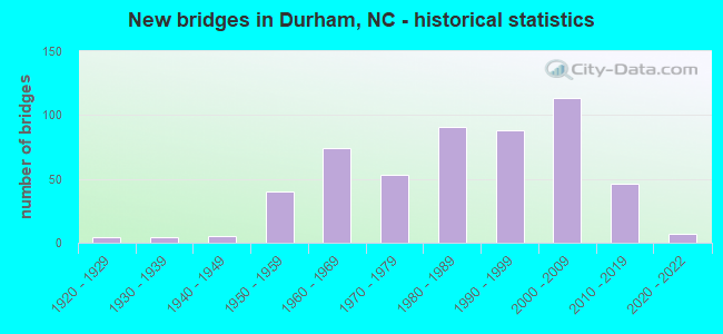
- New bridges - historical statistics
- 41920-1929
- 41930-1939
- 51940-1949
- 401950-1959
- 741960-1969
- 531970-1979
- 911980-1989
- 881990-1999
- 1132000-2009
- 462010-2019
- 72020-2022
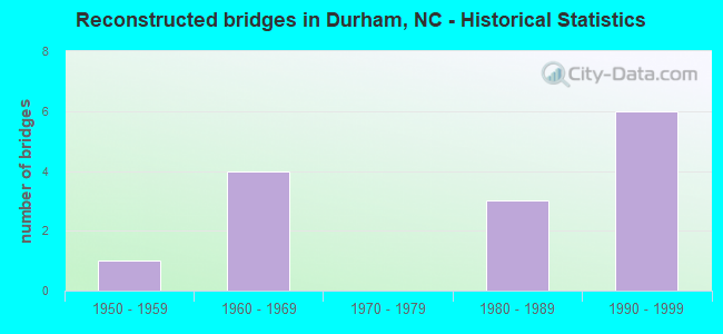
- Reconstructed bridges - Historical Statistics
- 11950-1959
- 41960-1969
- 01970-1979
- 31980-1989
- 61990-1999
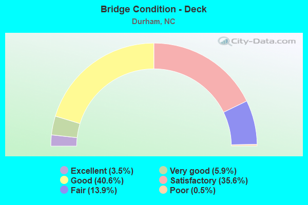
- Bridge Condition - Deck
- 3.5%Excellent
- 5.9%Very good
- 40.6%Good
- 35.6%Satisfactory
- 13.9%Fair
- 0.5%Poor
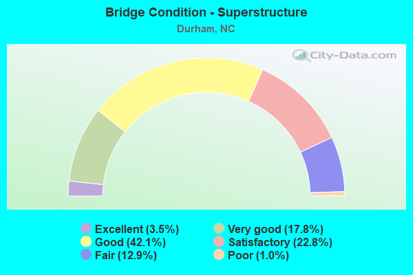
- Bridge Condition - Superstructure
- 3.5%Excellent
- 17.8%Very good
- 42.1%Good
- 22.8%Satisfactory
- 12.9%Fair
- 1.0%Poor
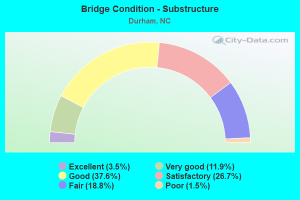
- Bridge Condition - Substructure
- 3.5%Excellent
- 11.9%Very good
- 37.6%Good
- 26.7%Satisfactory
- 18.8%Fair
- 1.5%Poor
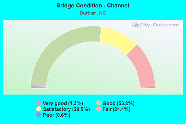
- Bridge Condition - Channel
- 1.3%Very good
- 53.2%Good
- 20.5%Satisfactory
- 24.4%Fair
- 0.6%Poor
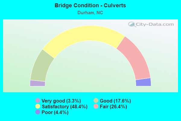
- Bridge Condition - Culverts
- 3.3%Very good
- 17.6%Good
- 48.4%Satisfactory
- 26.4%Fair
- 4.4%Poor
Find on map >> Show street view
Structure Number: 630458, Location: .65 MI.N. OF JCT US15/501 (Lat: 36.023111, Lng: -78.958767), Route carried "under" structure: State highway 1317, Year Built: 1996, Structure Length: 0. m, Average Daily Traffic: 4,600 (year 2015), Truck Traffic: 7%, Features Intersected: NC 147 SBL
Minimum Vertical Clearance: 6.40m (21.00ft), Kilometerpoint: 0.000, Lanes on structure: 2, Lanes under structure: 3, Material/Design: Prestressed concrete continuous, Design/Construction: Stringer/Multi-beam, Length of Maximum Span: 20.1m (65.9ft)
Find on map >> Show street view
Structure Number: 630459, Location: .65 MI.N. OF JCT US15/501 (Lat: 36.023161, Lng: -78.958564), Route carried "under" structure: State highway 1317, Year Built: 1996, Structure Length: 0. m, Average Daily Traffic: 4,600 (year 2015), Truck Traffic: 7%, Features Intersected: NC147 N
Minimum Vertical Clearance: 5.25m (17.22ft), Kilometerpoint: 4.968, Lanes on structure: 2, Lanes under structure: 3, Material/Design: Prestressed concrete continuous, Design/Construction: Stringer/Multi-beam, Length of Maximum Span: 20.1m (65.9ft)
Find on map >> Show street view
Structure Number: 630589, Location: .22 MI. W. JCT SR1999 (Lat: 35.876664, Lng: -78.866581), Route carried "under" structure: State highway 147, Year Built: 2011, Structure Length: 0. m, Average Daily Traffic: 8,000 (year 2019), Truck Traffic: 12%, Features Intersected: SR1978
Minimum Vertical Clearance: 6.50m (21.33ft), Kilometerpoint: 0.000, Lanes on structure: 6, Lanes under structure: 3, Material/Design: Prestressed concrete continuous, Design/Construction: Stringer/Multi-beam, Length of Maximum Span: 22.8m (74.8ft)
Find on map >> Show street view
Structure Number: 630589, Location: .22 MI. W. JCT SR1999 (Lat: 35.876664, Lng: -78.866581), Route carried "under" structure: State highway 147, Year Built: 2011, Structure Length: 0. m, Average Daily Traffic: 8,000 (year 2019), Truck Traffic: 12%, Features Intersected: SR1978
Minimum Vertical Clearance: 6.27m (20.57ft), Kilometerpoint: 0.000, Lanes on structure: 6, Lanes under structure: 3, Material/Design: Prestressed concrete continuous, Design/Construction: Stringer/Multi-beam, Length of Maximum Span: 22.8m (74.8ft)
Find on map >> Show street view
Structure Number: 630593, Location: 0.9 MI E. JCT SR1801 (Lat: 35.991242, Lng: -78.862644), Route carried "under" structure: State highway 98, Year Built: 2015, Structure Length: 0. m, Average Daily Traffic: 2,100 (year 2019), Truck Traffic: 7%, Features Intersected: US70
Minimum Vertical Clearance: 6.09m (19.98ft), Kilometerpoint: 0.000, Lanes on structure: 5, Lanes under structure: 4, Material/Design: Prestressed concrete, Design/Construction: Stringer/Multi-beam, Length of Maximum Span: 39.0m (128.0ft)
Find on map >> Show street view
Structure Number: 630594, Location: .10 MI.W.JCT. N.HOOVER RD (Lat: 35.981058, Lng: -78.857050), Route carried "under" structure: US 70, Year Built: 2020, Structure Length: 0. m, Average Daily Traffic: 5,000 (year 2019), Truck Traffic: 16%, Features Intersected: CARR ROAD
Minimum Vertical Clearance: 5.30m (17.39ft), Kilometerpoint: 0.000, Lanes on structure: 2, Lanes under structure: 3, Material/Design: Prestressed concrete, Design/Construction: Stringer/Multi-beam, Length of Maximum Span: 42.6m (139.8ft)
Find on map >> Show street view
Structure Number: 630594, Location: .10 MI.W.JCT. N.HOOVER RD (Lat: 35.981058, Lng: -78.857050), Route carried "under" structure: US 70, Year Built: 2020, Structure Length: 0. m, Average Daily Traffic: 5,000 (year 2019), Truck Traffic: 16%, Features Intersected: CARR ROAD
Minimum Vertical Clearance: 5.82m (19.09ft), Kilometerpoint: 0.000, Lanes on structure: 2, Lanes under structure: 2, Material/Design: Prestressed concrete, Design/Construction: Stringer/Multi-beam, Length of Maximum Span: 42.6m (139.8ft)
Find on map >> Show street view
Structure Number: 630595, Location: 0.5 MI W. JCT. SR1921 (Lat: 35.975389, Lng: -78.854750), Route carried "under" structure: Ramp State highway , Year Built: 2014, Structure Length: 0. m, Average Daily Traffic: 100 (year 2021), Truck Traffic: 7%, Features Intersected: US70E, Facility Carried by Structure: EASTEND CONNECTOR,
Minimum Vertical Clearance: 10.54m (34.58ft), Kilometerpoint: 0.000, Lanes on structure: 3, Lanes under structure: 1, Material/Design: Steel, Design/Construction: Stringer/Multi-beam, Length of Maximum Span: 41.4m (135.8ft)
Find on map >> Show street view
Structure Number: 630595, Location: 0.5 MI W. JCT. SR1921 (Lat: 35.975389, Lng: -78.854750), Route carried "under" structure: Ramp State highway , Year Built: 2014, Structure Length: 0. m, Average Daily Traffic: 100 (year 2021), Truck Traffic: 7%, Features Intersected: US70E, Facility Carried by Structure: EASTEND CONNECTOR,
Minimum Vertical Clearance: 7.16m (23.49ft), Kilometerpoint: 0.000, Lanes on structure: 3, Lanes under structure: 1, Material/Design: Steel, Design/Construction: Stringer/Multi-beam, Length of Maximum Span: 41.4m (135.8ft)
Find on map >> Show street view
Structure Number: 630596, Location: 0.8 MI. E. JCT. NC147 (Lat: 35.976167, Lng: -78.854139), Route carried "under" structure: US 70, Year Built: 2014, Structure Length: 0. m, Average Daily Traffic: 11,500 (year 2017), Truck Traffic: 7%, Features Intersected: US70 FLYOVER
Minimum Vertical Clearance: 17.54m (57.55ft), Kilometerpoint: 0.000, Lanes on structure: 1, Lanes under structure: 1, Material/Design: Steel, Design/Construction: Stringer/Multi-beam, Length of Maximum Span: 49.6m (162.7ft)
Find on map >> Show street view
Structure Number: 630596, Location: 0.8 MI. E. JCT. NC147 (Lat: 35.976167, Lng: -78.854139), Route carried "under" structure: US 70, Year Built: 2014, Structure Length: 0. m, Average Daily Traffic: 23,000 (year 2017), Truck Traffic: 12%, Features Intersected: US70 FLYOVER
Minimum Vertical Clearance: 9.93m (32.58ft), Kilometerpoint: 0.000, Lanes on structure: 1, Lanes under structure: 2, Material/Design: Steel, Design/Construction: Stringer/Multi-beam, Length of Maximum Span: 49.6m (162.7ft)
Find on map >> Show street view
Structure Number: 630596, Location: 0.8 MI. E. JCT. NC147 (Lat: 35.976167, Lng: -78.854139), Route carried "under" structure: US 70, Year Built: 2014, Structure Length: 0. m, Average Daily Traffic: 23,000 (year 2017), Truck Traffic: 12%, Features Intersected: US70 FLYOVER
Minimum Vertical Clearance: 5.43m (17.81ft), Kilometerpoint: 0.000, Lanes on structure: 1, Lanes under structure: 3, Material/Design: Steel, Design/Construction: Stringer/Multi-beam, Length of Maximum Span: 49.6m (162.7ft)
Find on map >> Show street view
Structure Number: 630596, Location: 0.8 MI. E. JCT. NC147 (Lat: 35.976167, Lng: -78.854139), Route carried "under" structure: Ramp US 70, Year Built: 2014, Structure Length: 0. m, Average Daily Traffic: 11,500 (year 2017), Truck Traffic: 12%, Features Intersected: US70 FLYOVER
Minimum Vertical Clearance: 13.41m (44.00ft), Kilometerpoint: 0.000, Lanes on structure: 1, Lanes under structure: 1, Material/Design: Steel, Design/Construction: Stringer/Multi-beam, Length of Maximum Span: 49.6m (162.7ft)
Find on map >> Show street view
Structure Number: 630597, Location: 0.6 MI. S. JCT. U.S. 70 (Lat: 35.971564, Lng: -78.858328), Route carried "under" structure: City street , Year Built: 2015, Structure Length: 0. m, Average Daily Traffic: 100 (year 2019), Truck Traffic: 7%, Features Intersected: I885S, Facility Carried by Structure: ROWENA AVE.
Minimum Vertical Clearance: 4.93m (16.17ft), Kilometerpoint: 0.000, Lanes on structure: 3, Lanes under structure: 2, Material/Design: Steel, Design/Construction: Stringer/Multi-beam, Length of Maximum Span: 40.2m (131.9ft)
Find on map >> Show street view
Structure Number: 630598, Location: 0.7 MI. N. JCT. NC.147 (Lat: 35.971361, Lng: -78.858258), Route carried "under" structure: City street , Year Built: 2015, Structure Length: 0. m, Average Daily Traffic: 100 (year 2019), Truck Traffic: 7%, Features Intersected: I885N, Facility Carried by Structure: ROWENA AVE.
Minimum Vertical Clearance: 6.88m (22.57ft), Kilometerpoint: 0.000, Lanes on structure: 4, Lanes under structure: 2, Material/Design: Steel, Design/Construction: Stringer/Multi-beam, Length of Maximum Span: 40.2m (131.9ft)
Find on map >> Show street view
Structure Number: 630599, Location: 0.5 MI.S.JCT.US70 (Lat: 35.969203, Lng: -78.862006), Route carried "under" structure: City street , Year Built: 2021, Structure Length: 0. m, Average Daily Traffic: 8,700 (year 2019), Truck Traffic: 7%, Features Intersected: I885S, Facility Carried by Structure: ANGIER AVE.
Minimum Vertical Clearance: 9.00m (29.53ft), Kilometerpoint: 0.000, Lanes on structure: 4, Lanes under structure: 2, Material/Design: Steel continuous, Design/Construction: Stringer/Multi-beam, Length of Maximum Span: 56.6m (185.7ft)
Find on map >> Show street view
Structure Number: 630599, Location: 0.5 MI.S.JCT.US70 (Lat: 35.969203, Lng: -78.862006), Route carried "under" structure: City street , Year Built: 2021, Structure Length: 0. m, Average Daily Traffic: 100 (year 2019), Truck Traffic: 7%, Features Intersected: I885S, Facility Carried by Structure: RIGSBEE RD
Minimum Vertical Clearance: 8.22m (26.97ft), Kilometerpoint: 0.000, Lanes on structure: 4, Lanes under structure: 2, Material/Design: Steel continuous, Design/Construction: Stringer/Multi-beam, Length of Maximum Span: 56.6m (185.7ft)
Find on map >> Show street view
Structure Number: 6306, Location: 0.4 MI. N. JCT. NC147 (Lat: 35.969014, Lng: -78.861808), Route carried "under" structure: State highway 1926, Year Built: 2019, Structure Length: 0. m, Average Daily Traffic: 8,700 (year 2019), Truck Traffic: 7%, Features Intersected: 1885N
Minimum Vertical Clearance: 10.21m (33.50ft), Kilometerpoint: 0.000, Lanes on structure: 4, Lanes under structure: 2, Material/Design: Prestressed concrete, Design/Construction: Stringer/Multi-beam, Length of Maximum Span: 56.6m (185.7ft)
Find on map >> Show street view
Structure Number: 630601, Location: 0.1 MI. N. JCT NC 147 (Lat: 35.965997, Lng: -78.865386), Route carried "under" structure: Interstate 885, Year Built: 2015, Structure Length: 0. m, Average Daily Traffic: 100 (year 2020), Truck Traffic: 16%, Features Intersected: I885N RMP
Minimum Vertical Clearance: 5.48m (17.98ft), Kilometerpoint: 0.000, Lanes on structure: 2, Lanes under structure: 2, Material/Design: Steel continuous, Design/Construction: Stringer/Multi-beam, Length of Maximum Span: 53.3m (174.9ft)
Find on map >> Show street view
Structure Number: 630601, Location: 0.1 MI. N. JCT NC 147 (Lat: 35.965997, Lng: -78.865386), Route carried "under" structure: US 147, Year Built: 2015, Structure Length: 0. m, Average Daily Traffic: 2,000 (year 2019), Truck Traffic: 16%, Features Intersected: I885N RMP
Minimum Vertical Clearance: 16.35m (53.64ft), Kilometerpoint: 2.895, Lanes on structure: 2, Lanes under structure: 2, Material/Design: Steel continuous, Design/Construction: Stringer/Multi-beam, Length of Maximum Span: 53.3m (174.9ft)
Find on map >> Show street view
Structure Number: 630602, Location: 1.2 MI. S. JCT. US70 (Lat: 35.965283, Lng: -78.865492), Route carried "under" structure: State highway 147, Year Built: 2019, Structure Length: 0. m, Average Daily Traffic: 37,750 (year 2019), Truck Traffic: 12%, Features Intersected: NC147RAMP
Minimum Vertical Clearance: 6.31m (20.70ft), Kilometerpoint: 2.895, Lanes on structure: 2, Lanes under structure: 2, Material/Design: Prestressed concrete, Design/Construction: Stringer/Multi-beam, Length of Maximum Span: 22.2m (72.8ft)
Find on map >> Show street view
Structure Number: 13501, Location: 0.5 MI. S. JCT. US70 (Lat: 36.038878, Lng: -79.017117), Route carried "under" structure: State highway 1713, Year Built: 1958, Structure Length: 0. m, Average Daily Traffic: 2,900 (year 2019), Truck Traffic: 7%, Features Intersected: I85S
Minimum Vertical Clearance: 5.86m (19.23ft), Kilometerpoint: 0.000, Lanes on structure: 2, Lanes under structure: 2, Material/Design: Steel, Design/Construction: Stringer/Multi-beam, Length of Maximum Span: 16.4m (53.8ft)
Find on map >> Show street view
Structure Number: 1350103, Location: 0.65 MI. N. JCT. SR1567 (Lat: 36.038503, Lng: -79.011719), Route carried "under" structure: US 70, Year Built: 1958, Structure Length: 0. m, Average Daily Traffic: 18,500 (year 2019), Truck Traffic: 6%, Features Intersected: I85N
Minimum Vertical Clearance: 4.87m (15.98ft), Kilometerpoint: 0.000, Lanes on structure: 2, Lanes under structure: 2, Material/Design: Steel, Design/Construction: Stringer/Multi-beam, Length of Maximum Span: 23.1m (75.8ft)