Bridge Statistics for Detroit, Michigan (MI)
Condition, Traffic, Stress, Structural Evaluation, Project Costs
- National Bridge Inventory (NBI) Statistics
- 1,085Number of bridges
- 12,034ft / 3,668mTotal length
- $82,595,000Total costs
- 55,047,582Total average daily traffic
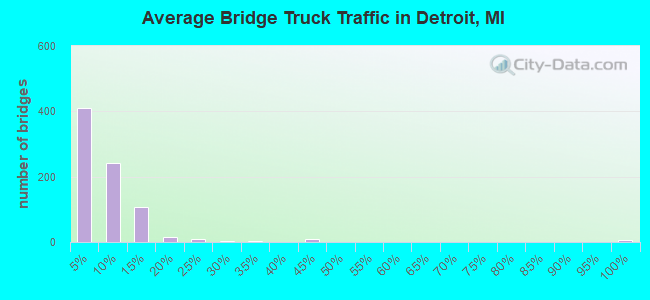
- 3,107,918Total average daily truck traffic
- National Bridge Inventory (NBI) Registered Bridges for Detroit
- No street view available for this location
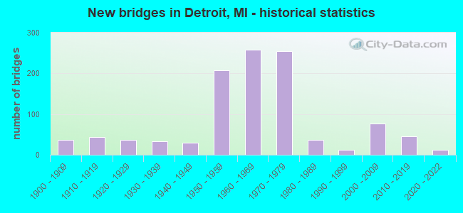
- New bridges - historical statistics
- 1Before 1900
- 371900-1909
- 431910-1919
- 371920-1929
- 331930-1939
- 291940-1949
- 2071950-1959
- 2591960-1969
- 2551970-1979
- 361980-1989
- 131990-1999
- 762000-2009
- 462010-2019
- 132020-2022
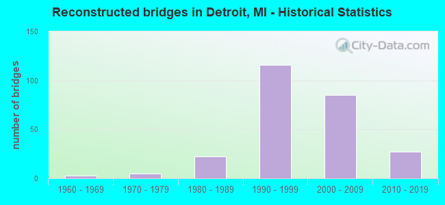
- Reconstructed bridges - Historical Statistics
- 31960-1969
- 51970-1979
- 221980-1989
- 1161990-1999
- 852000-2009
- 272010-2019
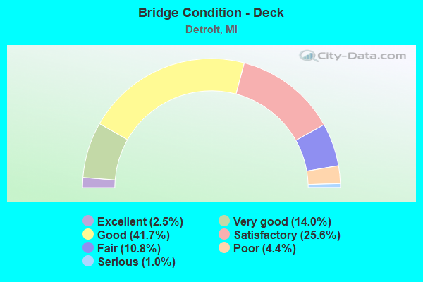
- Bridge Condition - Deck
- 2.5%Excellent
- 14.0%Very good
- 41.7%Good
- 25.6%Satisfactory
- 10.8%Fair
- 4.4%Poor
- 1.0%Serious
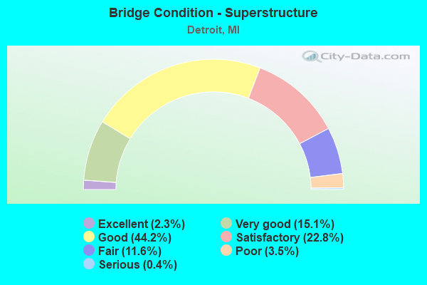
- Bridge Condition - Superstructure
- 2.3%Excellent
- 15.1%Very good
- 44.2%Good
- 22.8%Satisfactory
- 11.6%Fair
- 3.5%Poor
- 0.4%Serious
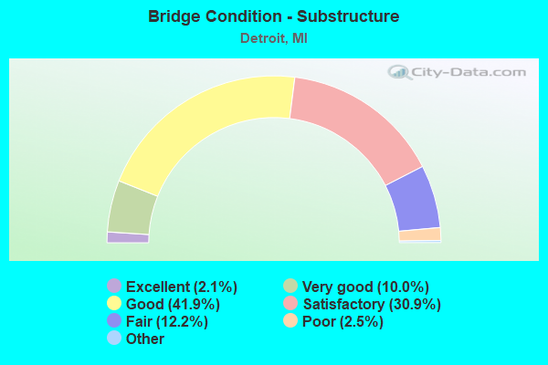
- Bridge Condition - Substructure
- 2.1%Excellent
- 10.0%Very good
- 41.9%Good
- 30.9%Satisfactory
- 12.2%Fair
- 2.5%Poor
- 0.4%Serious
- 0.2%Failed
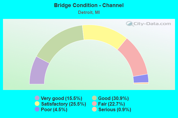
- Bridge Condition - Channel
- 15.5%Very good
- 30.9%Good
- 25.5%Satisfactory
- 22.7%Fair
- 4.5%Poor
- 0.9%Serious
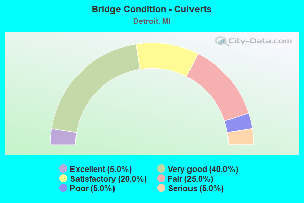
- Bridge Condition - Culverts
- 5.0%Excellent
- 40.0%Very good
- 20.0%Satisfactory
- 25.0%Fair
- 5.0%Poor
- 5.0%Serious
Find on map >> Show street view
Structure Number: 11466, Location: N LTS OF DETROIT (Lat: 42.444578, Lng: -83.202881), Route carried "on" structure: ServiceState highway 102, Year Built: 1965, Year Reconstructed: 2009, Status: Open, Structure Length: 6.58m (21.59ft), Average Daily Traffic: 14,430 (year 1982), Truck Traffic: 3%, Average Future Daily Traffic: 35,685 (year 2029), Design Load: HS 20, Features Intersected: M-10
Minimum Vertical Clearance: 30.48m (100.00ft), Kilometerpoint: 0.470, Lanes on structure: 2, Lanes under structure: 7, Owner: State Highway Agency, Approaching Roadway Width: 12.8m (42.0ft), Skew: 4 degrees, Material/Design: Steel, Design/Construction: Stringer/Multi-beam, Number Of Spans In Main Unit: 3, Length of Maximum Span: 23.1m (75.8ft), Curb or Sidewalk Widths: Left: 0.0m, Right: 2.7m (8.9ft), Curb-To-Curb Width: 12.8m (42.0ft), Out-to-Out Width: 16.3m (53.5ft)
Condition: Deck: Good, Superstructure: Good, Substructure: Good, Operating Rating: 95.3 metric tons, Method Used To Determine Operating Rating: Load Factor (LF), Inventory Rating: 57.1 metric tons, Method Used To Determine Inventory Rating: Load Factor (LF), Structural Evaluation: Better than present minimum criteria, Deck Geometry: Equal to present desirable criteria, Underclear: High priority of corrective action, Approach Roadway Alignment: Better than present minimum criteria, Designated Inspection Frequency: Every 24 months, Inspection Date: August 2020, Deck Structure Type: Concrete Cast-file-Place, Wearing Surface/Protective System: Wearing Surface: Monolithic Concrete, Deck Protection: Epoxy Coated Reinforcing
Find on map >> Show street view
Structure Number: 11467, Location: IN DETROIT (Lat: 42.444789, Lng: -83.200514), Route carried "on" structure: State highway 102, Year Built: 1965, Year Reconstructed: 2009, Status: Open, Structure Length: 56.03m (183.83ft), Average Daily Traffic: 38,892 (year 2007), Truck Traffic: 3%, Average Future Daily Traffic: 26,730 (year 2029), Design Load: HS 20, Features Intersected: M-10 & RAMPS
Minimum Vertical Clearance: 30.48m (100.00ft), Kilometerpoint: 9.932, Lanes on structure: 6, Lanes under structure: 21, Base Highway Network: Yes (Inventory Route: 181, Subroute: 6), Owner: State Highway Agency, Approaching Roadway Width: 25.6m (84.0ft), Skew: 39 degrees, Material/Design: Steel continuous, Design/Construction: Stringer/Multi-beam, Number Of Spans In Main Unit: 3, Number Of Approach Spans: 12, Length of Maximum Span: 64.7m (212.3ft), Curb-To-Curb Width: 26.8m (87.9ft), Out-to-Out Width: 28.2m (92.5ft)
Condition: Deck: Good, Superstructure: Good, Substructure: Satisfactory, Operating Rating: 73.5 metric tons, Method Used To Determine Operating Rating: Load Factor (LF) rating reported by rating factor (RF) method using MS18 loading, Inventory Rating: 44.1 metric tons, Method Used To Determine Inventory Rating: Load Factor (LF) rating reported by rating factor (RF) method using MS18 loading, Structural Evaluation: Equal to present minimum criteria, Deck Geometry: Better than present minimum criteria, Underclear: High priority of corrective action, Approach Roadway Alignment: Equal to present desirable criteria, Designated Inspection Frequency: Every 24 months, Inspection Date: March 2020, Deck Structure Type: Concrete Cast-file-Place, Wearing Surface/Protective System: Wearing Surface: Latex Concrete, Deck Protection: Epoxy Coated Reinforcing
Find on map >> Show street view
Structure Number: 11468, Location: IN DETROIT (Lat: 42.442989, Lng: -83.201017), Route carried "on" structure: Ramp State highway 10, Year Built: 1964, Year Reconstructed: 2006, Status: Open, Structure Length: 3.38m (11.09ft), Average Daily Traffic: 13,397 (year 2007), Truck Traffic: 2%, Average Future Daily Traffic: 20,854 (year 2018), Design Load: HS 20, Features Intersected: M-10, Facility Carried by Structure: GREENFIELD RD LF T
Minimum Vertical Clearance: 30.48m (100.00ft), Kilometerpoint: 0.019, Lanes on structure: 1, Lanes under structure: 7, Owner: State Highway Agency, Approaching Roadway Width: 4.8m (15.7ft), Material/Design: Steel, Design/Construction: Stringer/Multi-beam, Number Of Spans In Main Unit: 2, Length of Maximum Span: 16.9m (55.4ft), Curb-To-Curb Width: 6.1m (20.0ft), Out-to-Out Width: 6.8m (22.3ft)
Condition: Deck: Satisfactory, Superstructure: Satisfactory, Substructure: Satisfactory, Operating Rating: 72.4 metric tons, Method Used To Determine Operating Rating: Load Factor (LF), Inventory Rating: 43.3 metric tons, Method Used To Determine Inventory Rating: Load Factor (LF), Structural Evaluation: Equal to present minimum criteria, Deck Geometry: Somewhat better than minimum adequacy, Underclear: High priority of corrective action, Approach Roadway Alignment: Better than present minimum criteria, Designated Inspection Frequency: Every 24 months, Inspection Date: August 2020, Deck Structure Type: Concrete Cast-file-Place, Wearing Surface/Protective System: Wearing Surface: Monolithic Concrete, Deck Protection: Epoxy Coated Reinforcing
Find on map >> Show street view
Structure Number: 11469, Location: IN DETROIT (Lat: 42.404928, Lng: -83.141833), Route carried "on" structure: City street 2000, Year Built: 1987, Status: Open, Structure Length: 3.53m (11.58ft), Average Daily Traffic: 48,080 (year 1978), Truck Traffic: 3%, Average Future Daily Traffic: 48,080 (year 1977), Design Load: HS 20, Features Intersected: M-10, Facility Carried by Structure: LIVERNOIS AV UTURN
Minimum Vertical Clearance: 30.48m (100.00ft), Kilometerpoint: 0.053, Lanes on structure: 2, Lanes under structure: 6, Owner: State Highway Agency, Approaching Roadway Width: 9.1m (29.9ft), Material/Design: Prestressed concrete, Design/Construction: Box Beam or Girders - Multiple, Number Of Spans In Main Unit: 2, Length of Maximum Span: 17.3m (56.8ft), Curb or Sidewalk Widths: Left: 3.3m (10.8ft), Right: 0.2m (0.7ft), Curb-To-Curb Width: 9.1m (29.9ft), Out-to-Out Width: 13.4m (44.0ft)
Condition: Deck: Good, Superstructure: Satisfactory, Substructure: Good, Operating Rating: 63.2 metric tons, Method Used To Determine Operating Rating: Load Factor (LF) rating reported by rating factor (RF) method using MS18 loading, Inventory Rating: 18.8 metric tons, Method Used To Determine Inventory Rating: Load Factor (LF) rating reported by rating factor (RF) method using MS18 loading, Structural Evaluation: Meets minimum limits, Deck Geometry: Meets minimum limits, Underclear: High priority of corrective action, Approach Roadway Alignment: Equal to present minimum criteria, Designated Inspection Frequency: Every 24 months, Inspection Date: April 2021, Deck Structure Type: Concrete Cast-file-Place, Wearing Surface/Protective System: Wearing Surface: Latex Concrete, Deck Protection: Epoxy Coated Reinforcing
Find on map >> Show street view
Structure Number: 11473, Location: IN DETROIT (Lat: 42.420547, Lng: -83.268053), Route carried "on" structure: State highway 5, Year Built: 2003, Status: Open, Structure Length: 3.12m (10.24ft), Average Daily Traffic: 9,098 (year 2007), Truck Traffic: 4%, Average Future Daily Traffic: 10,246 (year 2018), Design Load: HS 25 or greater, Features Intersected: ROUGE RIVER
Minimum Vertical Clearance: 30.48m (100.00ft), Kilometerpoint: 5.004, Lanes on structure: 4, Base Highway Network: Yes (Inventory Route: 160, Subroute: 4), Owner: State Highway Agency, Approaching Roadway Width: 12.2m (40.0ft), Skew: 3 degrees, Material/Design: Prestressed concrete, Design/Construction: Stringer/Multi-beam, Number Of Spans In Main Unit: 1, Length of Maximum Span: 29.5m (96.8ft), Curb or Sidewalk Widths: Left: 0.0m, Right: 1.8m (5.9ft), Curb-To-Curb Width: 15.9m (52.2ft), Out-to-Out Width: 18.4m (60.4ft)
Condition: Deck: Good, Superstructure: Very good, Substructure: Very good, Channel: Very good, Operating Rating: 68.0 metric tons, Method Used To Determine Operating Rating: Load Factor (LF) rating reported by rating factor (RF) method using MS18 loading, Inventory Rating: 41.8 metric tons, Method Used To Determine Inventory Rating: Load Factor (LF) rating reported by rating factor (RF) method using MS18 loading, Structural Evaluation: Equal to present desirable criteria, Deck Geometry: Meets minimum limits, Waterway Adequacy: Equal to present minimum criteria, Approach Roadway Alignment: Equal to present desirable criteria, Designated Inspection Frequency: Every 24 months, Inspection Date: November 2020, Deck Structure Type: Concrete Cast-file-Place, Wearing Surface/Protective System: Wearing Surface: Monolithic Concrete, Deck Protection: Epoxy Coated Reinforcing
Find on map >> Show street view
Structure Number: 11474, Location: IN DETROIT (Lat: 42.420739, Lng: -83.267825), Route carried "on" structure: State highway 5, Year Built: 2003, Status: Open, Structure Length: 3.12m (10.24ft), Average Daily Traffic: 9,098 (year 2007), Truck Traffic: 4%, Average Future Daily Traffic: 10,246 (year 2018), Design Load: HS 25 or greater, Features Intersected: ROUGE RIVER
Minimum Vertical Clearance: 30.48m (100.00ft), Kilometerpoint: 4.957, Lanes on structure: 4, Base Highway Network: Yes (Inventory Route: 160, Subroute: 5), Owner: State Highway Agency, Approaching Roadway Width: 12.2m (40.0ft), Material/Design: Prestressed concrete, Design/Construction: Stringer/Multi-beam, Number Of Spans In Main Unit: 1, Length of Maximum Span: 29.8m (97.8ft), Curb or Sidewalk Widths: Left: 0.0m, Right: 1.8m (5.9ft), Curb-To-Curb Width: 15.9m (52.2ft), Out-to-Out Width: 18.5m (60.7ft)
Condition: Deck: Good, Superstructure: Very good, Substructure: Very good, Channel: Very good, Operating Rating: 66.4 metric tons, Method Used To Determine Operating Rating: Load Factor (LF) rating reported by rating factor (RF) method using MS18 loading, Inventory Rating: 39.5 metric tons, Method Used To Determine Inventory Rating: Load Factor (LF) rating reported by rating factor (RF) method using MS18 loading, Structural Evaluation: Equal to present desirable criteria, Deck Geometry: Meets minimum limits, Waterway Adequacy: Equal to present minimum criteria, Approach Roadway Alignment: Equal to present desirable criteria, Designated Inspection Frequency: Every 24 months, Inspection Date: November 2020, Deck Structure Type: Concrete Cast-file-Place, Wearing Surface/Protective System: Wearing Surface: Monolithic Concrete, Deck Protection: Epoxy Coated Reinforcing
Find on map >> Show street view
Structure Number: 11479, Location: IN DETROIT (Lat: 42.385389, Lng: -83.266728), Route carried "on" structure: ServiceCity street , Year Built: 1970, Year Reconstructed: 2011, Status: Open, Structure Length: 8.23m (27.00ft), Average Daily Traffic: 3,265 (year 2010), Truck Traffic: 10%, Average Future Daily Traffic: 3,592 (year 2030), Design Load: HS 20+Mod, Features Intersected: ROUGE RIVER, Facility Carried by Structure: I-96 EB SERV RD
Minimum Vertical Clearance: 30.48m (100.00ft), Kilometerpoint: 15.128, Lanes on structure: 2, Owner: City or Municipal Highway Agency, Approaching Roadway Width: 7.3m (24.0ft), Skew: 3 degrees, Material/Design: Steel, Design/Construction: Stringer/Multi-beam, Number Of Spans In Main Unit: 3, Length of Maximum Span: 29.3m (96.1ft), Curb or Sidewalk Widths: Left: 1.1m (3.6ft), Right: 3.0m (9.8ft), Curb-To-Curb Width: 7.3m (24.0ft), Out-to-Out Width: 12.2m (40.0ft)
Condition: Deck: Good, Superstructure: Good, Substructure: Good, Channel: Fair, Operating Rating: 82.3 metric tons, Method Used To Determine Operating Rating: Load and Resistance Factor Rating (LRFR) rating reported by rating factor(RF) method using HL-93 loadings, Inventory Rating: 48.9 metric tons, Method Used To Determine Inventory Rating: Load and Resistance Factor Rating (LRFR) rating reported by rating factor(RF) method using HL-93 loadings, Structural Evaluation: Better than present minimum criteria, Deck Geometry: High priority of replacement, Waterway Adequacy: Equal to present desirable criteria, Approach Roadway Alignment: Equal to present desirable criteria, Designated Inspection Frequency: Every 24 months, Inspection Date: June 2020, Deck Structure Type: Concrete Cast-file-Place, Wearing Surface/Protective System: Wearing Surface: Monolithic Concrete, Deck Protection: Epoxy Coated Reinforcing
Find on map >> Show street view
Structure Number: 1148, Location: IN DETROIT (Lat: 42.385561, Lng: -83.266789), Route carried "on" structure: Interstate 96, Year Built: 1970, Year Reconstructed: 2003, Status: Open, Structure Length: 8.23m (27.00ft), Average Daily Traffic: 164,804 (year 2007), Truck Traffic: 5%, Average Future Daily Traffic: 170,480 (year 2018), Design Load: HS 20+Mod, Features Intersected: ROUGE RIVER
Minimum Vertical Clearance: 30.48m (100.00ft), Kilometerpoint: 14.971, Lanes on structure: 10, Base Highway Network: Yes (Inventory Route: 160, Subroute: 1), Owner: State Highway Agency, Approaching Roadway Width: 51.8m (169.9ft), Skew: 33 degrees, Material/Design: Prestressed concrete, Design/Construction: Stringer/Multi-beam, Number Of Spans In Main Unit: 3, Length of Maximum Span: 29.2m (95.8ft), Curb-To-Curb Width: 51.6m (169.3ft), Out-to-Out Width: 53.6m (175.9ft)
Condition: Deck: Good, Superstructure: Very good, Substructure: Very good, Channel: Good, Operating Rating: 76.5 metric tons, Method Used To Determine Operating Rating: Load Factor (LF) rating reported by rating factor (RF) method using MS18 loading, Inventory Rating: 29.2 metric tons, Method Used To Determine Inventory Rating: Load Factor (LF) rating reported by rating factor (RF) method using MS18 loading, Structural Evaluation: Better than present minimum criteria, Deck Geometry: Superior to present desirable criteria, Waterway Adequacy: Equal to present desirable criteria, Approach Roadway Alignment: Equal to present desirable criteria, Designated Inspection Frequency: Every 24 months, Inspection Date: April 2020, Deck Structure Type: Concrete Cast-file-Place, Wearing Surface/Protective System: Wearing Surface: Monolithic Concrete, Deck Protection: Epoxy Coated Reinforcing
Find on map >> Show street view
Structure Number: 11481, Location: IN DETROIT (Lat: 42.386042, Lng: -83.266800), Route carried "on" structure: ServiceCity street , Year Built: 1970, Year Reconstructed: 2011, Status: Open, Structure Length: 8.23m (27.00ft), Average Daily Traffic: 1,087 (year 2010), Truck Traffic: 10%, Average Future Daily Traffic: 1,196 (year 2030), Design Load: HS 20+Mod, Features Intersected: ROUGE RIVER, Facility Carried by Structure: I-96 WB SERV RD
Minimum Vertical Clearance: 30.48m (100.00ft), Kilometerpoint: 15.153, Lanes on structure: 2, Owner: City or Municipal Highway Agency, Approaching Roadway Width: 7.3m (24.0ft), Skew: 3 degrees, Material/Design: Steel, Design/Construction: Stringer/Multi-beam, Number Of Spans In Main Unit: 3, Length of Maximum Span: 29.3m (96.1ft), Curb or Sidewalk Widths: Left: 3.0m (9.8ft), Right: 1.1m (3.6ft), Curb-To-Curb Width: 7.3m (24.0ft), Out-to-Out Width: 12.2m (40.0ft)
Condition: Deck: Good, Superstructure: Very good, Substructure: Good, Channel: Fair, Operating Rating: 82.0 metric tons, Method Used To Determine Operating Rating: Load and Resistance Factor Rating (LRFR) rating reported by rating factor(RF) method using HL-93 loadings, Inventory Rating: 48.9 metric tons, Method Used To Determine Inventory Rating: Load and Resistance Factor Rating (LRFR) rating reported by rating factor(RF) method using HL-93 loadings, Structural Evaluation: Better than present minimum criteria, Deck Geometry: High priority of replacement, Waterway Adequacy: Equal to present minimum criteria, Approach Roadway Alignment: Equal to present desirable criteria, Designated Inspection Frequency: Every 24 months, Inspection Date: June 2020, Deck Structure Type: Concrete Cast-file-Place, Wearing Surface/Protective System: Wearing Surface: Monolithic Concrete, Deck Protection: Epoxy Coated Reinforcing
Find on map >> Show street view
Structure Number: 11485, Location: IN DETROIT (Lat: 42.377747, Lng: -83.236500), Route carried "on" structure: City street , Year Built: 1971, Status: Open, Structure Length: 41.03m (134.61ft), Average Daily Traffic: 18,637 (year 2016), Truck Traffic: 6%, Average Future Daily Traffic: 21,925 (year 2036), Design Load: HS 20, Features Intersected: I-96 & CSX RR, Facility Carried by Structure: EVERGREEN RD
Minimum Vertical Clearance: 30.48m (100.00ft), Kilometerpoint: 8.139, Lanes on structure: 7, Lanes under structure: 12, Base Highway Network: Yes (Inventory Route: 159, Subroute: 8), Owner: State Highway Agency, Approaching Roadway Width: 21.3m (69.9ft), Skew: 9 degrees, Material/Design: Steel, Design/Construction: Stringer/Multi-beam, Number Of Spans In Main Unit: 19, Length of Maximum Span: 27.4m (89.9ft), Curb or Sidewalk Widths: Left: 3.0m (9.8ft), Right: 3.0m (9.8ft), Curb-To-Curb Width: 21.3m (69.9ft), Out-to-Out Width: 28.2m (92.5ft)
Condition: Deck: Good, Superstructure: Good, Substructure: Satisfactory, Operating Rating: 64.8 metric tons, Method Used To Determine Operating Rating: Load Factor (LF) rating reported by rating factor (RF) method using MS18 loading, Inventory Rating: 38.9 metric tons, Method Used To Determine Inventory Rating: Load Factor (LF) rating reported by rating factor (RF) method using MS18 loading, Structural Evaluation: Equal to present minimum criteria, Deck Geometry: High priority of replacement, Underclear: High priority of corrective action, Approach Roadway Alignment: Superior to present desirable criteria, Designated Inspection Frequency: Every 24 months, Inspection Date: October 2020, Deck Structure Type: Concrete Cast-file-Place, Wearing Surface/Protective System: Wearing Surface: Latex Concrete
Find on map >> Show street view
Structure Number: 11486, Location: IN DET,CONN TO EVERGREEN (Lat: 42.379397, Lng: -83.237292), Route carried "on" structure: ServiceCity street , Year Built: 1971, Status: Open, Structure Length: 7.62m (25.00ft), Average Daily Traffic: 2,181 (year 2008), Average Future Daily Traffic: 4,424 (year 2024), Design Load: HS 20, Features Intersected: LAND, Facility Carried by Structure: S SERVICE RD
Minimum Vertical Clearance: 30.48m (100.00ft), Kilometerpoint: 0.985, Lanes on structure: 2, Owner: City or Municipal Highway Agency, Approaching Roadway Width: 8.8m (28.9ft), Material/Design: Steel, Design/Construction: Stringer/Multi-beam, Number Of Spans In Main Unit: 5, Length of Maximum Span: 16.7m (54.8ft), Curb or Sidewalk Widths: Left: 0.2m (0.7ft), Right: 2.4m (7.9ft), Curb-To-Curb Width: 8.8m (28.9ft), Out-to-Out Width: 12.1m (39.7ft)
Condition: Deck: Good, Superstructure: Very good, Substructure: Very good, Operating Rating: 56.7 metric tons, Method Used To Determine Operating Rating: Load and Resistance Factor Rating (LRFR) rating reported by rating factor(RF) method using HL-93 loadings, Inventory Rating: 34.0 metric tons, Method Used To Determine Inventory Rating: Load and Resistance Factor Rating (LRFR) rating reported by rating factor(RF) method using HL-93 loadings, Structural Evaluation: Equal to present desirable criteria, Deck Geometry: High priority of corrective action, Approach Roadway Alignment: Superior to present desirable criteria, Designated Inspection Frequency: Every 24 months, Inspection Date: June 2020, Deck Structure Type: Concrete Cast-file-Place, Wearing Surface/Protective System: Wearing Surface: Monolithic Concrete
Find on map >> Show street view
Structure Number: 11506, Location: IN DETROIT (Lat: 42.385256, Lng: -83.275764), Route carried "on" structure: ServiceUS 24, Year Built: 1970, Year Reconstructed: 2014, Status: Open, Structure Length: 5.06m (16.60ft), Average Daily Traffic: 17,760 (year 1982), Truck Traffic: 3%, Average Future Daily Traffic: 146,534 (year 2034), Design Load: HS 20, Features Intersected: I-96, Facility Carried by Structure: NB SERV RD
Minimum Vertical Clearance: 4.42m (14.50ft), Kilometerpoint: 0.406, Lanes on structure: 4, Lanes under structure: 8, Owner: State Highway Agency, Approaching Roadway Width: 18.6m (61.0ft), Skew: 10 degrees, Material/Design: Steel, Design/Construction: Stringer/Multi-beam, Number Of Spans In Main Unit: 2, Length of Maximum Span: 24.9m (81.7ft), Curb or Sidewalk Widths: Left: 0.2m (0.7ft), Right: 0.0m, Curb-To-Curb Width: 18.6m (61.0ft), Out-to-Out Width: 22.1m (72.5ft)
Condition: Deck: Good, Superstructure: Very good, Substructure: Good, Operating Rating: 67.7 metric tons, Method Used To Determine Operating Rating: Load Factor (LF) rating reported by rating factor (RF) method using MS18 loading, Inventory Rating: 40.5 metric tons, Method Used To Determine Inventory Rating: Load Factor (LF) rating reported by rating factor (RF) method using MS18 loading, Structural Evaluation: Better than present minimum criteria, Deck Geometry: Equal to present minimum criteria, Underclear: High priority of corrective action, Approach Roadway Alignment: Equal to present desirable criteria, Designated Inspection Frequency: Every 24 months, Inspection Date: April 2020, Deck Structure Type: Concrete Cast-file-Place, Wearing Surface/Protective System: Wearing Surface: Monolithic Concrete, Deck Protection: Epoxy Coated Reinforcing
Find on map >> Show street view
Structure Number: 11507, Location: IN DETROIT (Lat: 42.385239, Lng: -83.276425), Route carried "on" structure: ServiceUS 24, Year Built: 1970, Year Reconstructed: 2014, Status: Open, Structure Length: 5.06m (16.60ft), Average Daily Traffic: 17,760 (year 1982), Truck Traffic: 3%, Average Future Daily Traffic: 14,653 (year 2034), Design Load: HS 20, Features Intersected: I-96, Facility Carried by Structure: SB SERV RD
Minimum Vertical Clearance: 4.42m (14.50ft), Kilometerpoint: 0.423, Lanes on structure: 4, Lanes under structure: 8, Owner: State Highway Agency, Approaching Roadway Width: 18.6m (61.0ft), Skew: 30 degrees, Material/Design: Steel, Design/Construction: Stringer/Multi-beam, Number Of Spans In Main Unit: 2, Length of Maximum Span: 24.9m (81.7ft), Curb-To-Curb Width: 18.6m (61.0ft), Out-to-Out Width: 22.1m (72.5ft)
Condition: Deck: Very good, Superstructure: Very good, Substructure: Satisfactory, Operating Rating: 67.7 metric tons, Method Used To Determine Operating Rating: Load Factor (LF) rating reported by rating factor (RF) method using MS18 loading, Inventory Rating: 40.5 metric tons, Method Used To Determine Inventory Rating: Load Factor (LF) rating reported by rating factor (RF) method using MS18 loading, Structural Evaluation: Equal to present minimum criteria, Deck Geometry: Equal to present minimum criteria, Underclear: High priority of corrective action, Approach Roadway Alignment: Equal to present desirable criteria, Designated Inspection Frequency: Every 24 months, Inspection Date: April 2020, Deck Structure Type: Concrete Cast-file-Place, Wearing Surface/Protective System: Wearing Surface: Monolithic Concrete, Deck Protection: Epoxy Coated Reinforcing
Find on map >> Show street view
Structure Number: 11508, Location: IN DETROIT (Lat: 42.385428, Lng: -83.271111), Route carried "on" structure: City street , Year Built: 1970, Status: Open, Structure Length: 7.28m (23.88ft), Average Daily Traffic: 5,500 (year 1988), Average Future Daily Traffic: 6,325 (year 2008), Design Load: HS 20, Features Intersected: I-96, Facility Carried by Structure: VIRGIL ST
Minimum Vertical Clearance: 30.48m (100.00ft), Kilometerpoint: 0.724, Lanes on structure: 2, Lanes under structure: 11, Owner: State Highway Agency, Approaching Roadway Width: 11.2m (36.7ft), Material/Design: Steel, Design/Construction: Stringer/Multi-beam, Number Of Spans In Main Unit: 2, Length of Maximum Span: 42.6m (139.8ft), Curb or Sidewalk Widths: Left: 3.0m (9.8ft), Right: 3.0m (9.8ft), Curb-To-Curb Width: 11.2m (36.7ft), Out-to-Out Width: 18.1m (59.4ft)
Condition: Deck: Poor, Superstructure: Fair, Substructure: Fair, Operating Rating: 77.1 metric tons, Method Used To Determine Operating Rating: Load Factor (LF) rating reported by rating factor (RF) method using MS18 loading, Inventory Rating: 46.0 metric tons, Method Used To Determine Inventory Rating: Load Factor (LF) rating reported by rating factor (RF) method using MS18 loading, Structural Evaluation: Somewhat better than minimum adequacy, Deck Geometry: Meets minimum limits, Underclear: High priority of corrective action, Approach Roadway Alignment: Equal to present desirable criteria, Designated Inspection Frequency: Every 12 months, Inspection Date: April 2021, Bridge Improvement Cost: $351,000, Deck Structure Type: Concrete Cast-file-Place, Wearing Surface/Protective System: Wearing Surface: Monolithic Concrete
Find on map >> Show street view
Structure Number: 11509, Location: IN DETROIT (Lat: 42.385433, Lng: -83.256028), Route carried "on" structure: County highway 2057, Year Built: 1970, Year Reconstructed: 2003, Status: Open, Structure Length: 7.04m (23.10ft), Average Daily Traffic: 42,000 (year 1988), Truck Traffic: 3%, Average Future Daily Traffic: 48,300 (year 2008), Design Load: HS 20, Features Intersected: I-96, Facility Carried by Structure: OUTER DRIVE
Minimum Vertical Clearance: 30.48m (100.00ft), Kilometerpoint: 0.225, Lanes on structure: 10, Lanes under structure: 10, Owner: State Highway Agency, Approaching Roadway Width: 50.6m (166.0ft), Skew: 30 degrees, Material/Design: Steel, Design/Construction: Stringer/Multi-beam, Number Of Spans In Main Unit: 2, Length of Maximum Span: 35.0m (114.8ft), Curb or Sidewalk Widths: Left: 3.0m (9.8ft), Right: 3.0m (9.8ft), Curb-To-Curb Width: 50.6m (166.0ft), Out-to-Out Width: 51.8m (169.9ft)
Condition: Deck: Satisfactory, Superstructure: Satisfactory, Substructure: Good, Operating Rating: 79.8 metric tons, Method Used To Determine Operating Rating: Load Factor (LF), Inventory Rating: 47.8 metric tons, Method Used To Determine Inventory Rating: Load Factor (LF), Structural Evaluation: Equal to present minimum criteria, Deck Geometry: Superior to present desirable criteria, Underclear: High priority of corrective action, Approach Roadway Alignment: Equal to present desirable criteria, Designated Inspection Frequency: Every 24 months, Inspection Date: April 2020, Deck Structure Type: Concrete Cast-file-Place, Wearing Surface/Protective System: Wearing Surface: Monolithic Concrete, Deck Protection: Epoxy Coated Reinforcing
Find on map >> Show street view
Structure Number: 1151, Location: IN DETROIT (Lat: 42.385272, Lng: -83.246578), Route carried "on" structure: City street , Year Built: 1970, Year Reconstructed: 2003, Status: Open, Structure Length: 8.44m (27.69ft), Average Daily Traffic: 8,500 (year 1995), Average Future Daily Traffic: 8,500 (year 2015), Design Load: HS 20, Features Intersected: I-96, Facility Carried by Structure: BURT RD
Minimum Vertical Clearance: 30.48m (100.00ft), Kilometerpoint: 3.117, Lanes on structure: 4, Lanes under structure: 12, Owner: State Highway Agency, Approaching Roadway Width: 14.6m (47.9ft), Material/Design: Steel, Design/Construction: Stringer/Multi-beam, Number Of Spans In Main Unit: 4, Length of Maximum Span: 23.1m (75.8ft), Curb or Sidewalk Widths: Left: 3.0m (9.8ft), Right: 3.0m (9.8ft), Curb-To-Curb Width: 14.6m (47.9ft), Out-to-Out Width: 21.4m (70.2ft)
Condition: Deck: Satisfactory, Superstructure: Good, Substructure: Fair, Operating Rating: 97.2 metric tons, Method Used To Determine Operating Rating: Load Factor (LF) rating reported by rating factor (RF) method using MS18 loading, Inventory Rating: 58.6 metric tons, Method Used To Determine Inventory Rating: Load Factor (LF) rating reported by rating factor (RF) method using MS18 loading, Structural Evaluation: Somewhat better than minimum adequacy, Deck Geometry: High priority of replacement, Underclear: Meets minimum limits, Approach Roadway Alignment: Equal to present desirable criteria, Designated Inspection Frequency: Every 24 months, Inspection Date: April 2020, Deck Structure Type: Concrete Cast-file-Place, Wearing Surface/Protective System: Wearing Surface: Monolithic Concrete, Deck Protection: Epoxy Coated Reinforcing
Find on map >> Show street view
Structure Number: 11511, Location: IN DETROIT (Lat: 42.385683, Lng: -83.244597), Route carried "on" structure: City street 2000, Year Built: 1970, Year Reconstructed: 2003, Status: Open, Structure Length: 11.64m (38.19ft), Average Daily Traffic: 1,750 (year 2008), Average Future Daily Traffic: 2,000 (year 2025), Design Load: HS 20, Features Intersected: I-96, Facility Carried by Structure: SCHOOLCRAFT X-OVER
Minimum Vertical Clearance: 30.48m (100.00ft), Kilometerpoint: 16.929, Lanes on structure: 2, Lanes under structure: 12, Owner: State Highway Agency, Approaching Roadway Width: 7.3m (24.0ft), Skew: 3 degrees, Material/Design: Steel, Design/Construction: Stringer/Multi-beam, Number Of Spans In Main Unit: 4, Length of Maximum Span: 37.5m (123.0ft), Curb or Sidewalk Widths: Left: 2.9m (9.5ft), Right: 0.0m, Curb-To-Curb Width: 9.2m (30.2ft), Out-to-Out Width: 13.1m (43.0ft)
Condition: Deck: Satisfactory, Superstructure: Good, Substructure: Satisfactory, Operating Rating: 78.4 metric tons, Method Used To Determine Operating Rating: Load Factor (LF) rating reported by rating factor (RF) method using MS18 loading, Inventory Rating: 47.0 metric tons, Method Used To Determine Inventory Rating: Load Factor (LF) rating reported by rating factor (RF) method using MS18 loading, Structural Evaluation: Equal to present minimum criteria, Deck Geometry: Somewhat better than minimum adequacy, Underclear: High priority of corrective action, Approach Roadway Alignment: Equal to present desirable criteria, Designated Inspection Frequency: Every 24 months, Inspection Date: April 2020, Deck Structure Type: Concrete Cast-file-Place, Wearing Surface/Protective System: Wearing Surface: Monolithic Concrete, Deck Protection: Epoxy Coated Reinforcing
Find on map >> Show street view
Structure Number: 11512, Location: IN DETROIT (Lat: 42.382300, Lng: -83.238664), Route carried "on" structure: City street , Year Built: 1970, Year Reconstructed: 1995, Status: Open, Structure Length: 7.70m (25.26ft), Average Daily Traffic: 5,500 (year 1988), Average Future Daily Traffic: 6,325 (year 2008), Design Load: HS 20, Features Intersected: I-96, Facility Carried by Structure: GLENDALE AVE
Minimum Vertical Clearance: 30.48m (100.00ft), Kilometerpoint: 0.077, Lanes on structure: 2, Lanes under structure: 10, Owner: State Highway Agency, Approaching Roadway Width: 8.8m (28.9ft), Material/Design: Steel, Design/Construction: Stringer/Multi-beam, Number Of Spans In Main Unit: 4, Length of Maximum Span: 19.8m (65.0ft), Curb or Sidewalk Widths: Left: 3.0m (9.8ft), Right: 0.0m, Curb-To-Curb Width: 8.8m (28.9ft), Out-to-Out Width: 12.7m (41.7ft)
Condition: Deck: Satisfactory, Superstructure: Good, Substructure: Good, Operating Rating: 55.1 metric tons, Method Used To Determine Operating Rating: Load Factor (LF) rating reported by rating factor (RF) method using MS18 loading, Inventory Rating: 33.0 metric tons, Method Used To Determine Inventory Rating: Load Factor (LF) rating reported by rating factor (RF) method using MS18 loading, Structural Evaluation: Better than present minimum criteria, Deck Geometry: Meets minimum limits, Underclear: Meets minimum limits, Approach Roadway Alignment: Equal to present desirable criteria, Designated Inspection Frequency: Every 24 months, Inspection Date: November 2021, Deck Structure Type: Concrete Cast-file-Place, Wearing Surface/Protective System: Wearing Surface: Epoxy Overlay, Deck Protection: Epoxy Coated Reinforcing
Find on map >> Show street view
Structure Number: 11513, Location: IN DETROIT (Lat: 42.378347, Lng: -83.231411), Route carried "on" structure: ServiceOther road , Year Built: 1973, Status: Open, Structure Length: 7.68m (25.20ft), Average Daily Traffic: 5,500 (year 1988), Average Future Daily Traffic: 6,325 (year 2008), Design Load: HS 20, Features Intersected: I-96, Facility Carried by Structure: INDUSTRIAL AVE
Minimum Vertical Clearance: 30.48m (100.00ft), Kilometerpoint: 18.178, Lanes on structure: 2, Lanes under structure: 12, Owner: State Highway Agency, Approaching Roadway Width: 6.7m (22.0ft), Material/Design: Steel, Design/Construction: Stringer/Multi-beam, Number Of Spans In Main Unit: 4, Length of Maximum Span: 19.5m (64.0ft), Curb or Sidewalk Widths: Left: 0.4m (1.3ft), Right: 1.2m (3.9ft), Curb-To-Curb Width: 8.0m (26.2ft), Out-to-Out Width: 9.6m (31.5ft)
Condition: Deck: Satisfactory, Superstructure: Satisfactory, Substructure: Satisfactory, Operating Rating: 61.2 metric tons, Method Used To Determine Operating Rating: Load Factor (LF) rating reported by rating factor (RF) method using MS18 loading, Inventory Rating: 36.6 metric tons, Method Used To Determine Inventory Rating: Load Factor (LF) rating reported by rating factor (RF) method using MS18 loading, Structural Evaluation: Equal to present minimum criteria, Deck Geometry: High priority of corrective action, Underclear: Equal to present minimum criteria, Approach Roadway Alignment: Equal to present desirable criteria, Designated Inspection Frequency: Every 24 months, Inspection Date: September 2020, Bridge Improvement Cost: $132,000, Deck Structure Type: Concrete Cast-file-Place, Wearing Surface/Protective System: Wearing Surface: Monolithic Concrete
Find on map >> Show street view
Structure Number: 1154, Location: IN DETROIT (Lat: 42.379422, Lng: -83.217975), Route carried "on" structure: Ramp Interstate 96, Year Built: 1975, Status: Open, Structure Length: 8.50m (27.89ft), Average Daily Traffic: 18,870 (year 1982), Average Future Daily Traffic: 18,870 (year 1977), Design Load: HS 20, Features Intersected: CSX RR & FULLERTON AVE, Facility Carried by Structure: SB TO WB TURN RDWY
Minimum Vertical Clearance: 30.48m (100.00ft), Kilometerpoint: 0.451, Lanes on structure: 1, Lanes under structure: 2, Owner: State Highway Agency, Approaching Roadway Width: 5.4m (17.7ft), Material/Design: Steel continuous, Design/Construction: Stringer/Multi-beam, Number Of Spans In Main Unit: 3, Length of Maximum Span: 32.3m (106.0ft), Curb-To-Curb Width: 8.2m (26.9ft), Out-to-Out Width: 8.8m (28.9ft)
Condition: Deck: Satisfactory, Superstructure: Good, Substructure: Good, Operating Rating: 62.2 metric tons, Method Used To Determine Operating Rating: Load Factor (LF) rating reported by rating factor (RF) method using MS18 loading, Inventory Rating: 37.3 metric tons, Method Used To Determine Inventory Rating: Load Factor (LF) rating reported by rating factor (RF) method using MS18 loading, Structural Evaluation: Better than present minimum criteria, Deck Geometry: Superior to present desirable criteria, Underclear: Equal to present minimum criteria, Approach Roadway Alignment: Equal to present desirable criteria, Designated Inspection Frequency: Every 24 months, Inspection Date: August 2021, Deck Structure Type: Concrete Cast-file-Place, Wearing Surface/Protective System: Wearing Surface: Epoxy Overlay
Find on map >> Show street view
Structure Number: 11541, Location: IN DETROIT (Lat: 42.378403, Lng: -83.216306), Route carried "on" structure: Ramp Interstate 96, Year Built: 1973, Status: Open, Structure Length: 40.67m (133.43ft), Average Daily Traffic: 18,870 (year 1982), Average Future Daily Traffic: 21,701 (year 2002), Design Load: HS 20, Features Intersected: I-96 & CSX RR, Facility Carried by Structure: TURN RDWY 3RD LEVL
Minimum Vertical Clearance: 4.32m (14.17ft), Kilometerpoint: 0.155, Lanes on structure: 2, Lanes under structure: 14, Owner: State Highway Agency, Approaching Roadway Width: 8.2m (26.9ft), Material/Design: Steel continuous, Design/Construction: Stringer/Multi-beam, Number Of Spans In Main Unit: 16, Length of Maximum Span: 36.2m (118.8ft), Curb-To-Curb Width: 11.4m (37.4ft), Out-to-Out Width: 11.9m (39.0ft)
Condition: Deck: Fair, Superstructure: Satisfactory, Substructure: Good, Operating Rating: 64.8 metric tons, Method Used To Determine Operating Rating: Load Factor (LF) rating reported by rating factor (RF) method using MS18 loading, Inventory Rating: 38.9 metric tons, Method Used To Determine Inventory Rating: Load Factor (LF) rating reported by rating factor (RF) method using MS18 loading, Structural Evaluation: Equal to present minimum criteria, Deck Geometry: High priority of corrective action, Underclear: High priority of corrective action, Approach Roadway Alignment: Equal to present minimum criteria, Designated Inspection Frequency: Every 24 months, Critical Feature Inspection Frequency: Every 24 months, Inspection Date: August 2021, Critical Feature Inspection Date: September 2020, Deck Structure Type: Concrete Cast-file-Place, Wearing Surface/Protective System: Wearing Surface: Latex Concrete
Find on map >> Show street view
Structure Number: 11542, Location: IN DETROIT (Lat: 42.379461, Lng: -83.216750), Route carried "on" structure: ServiceInterstate 96, Year Built: 1973, Status: Open, Structure Length: 60.42m (198.23ft), Average Daily Traffic: 18,870 (year 1982), Truck Traffic: 5%, Average Future Daily Traffic: 18,870 (year 2015), Design Load: HS 20, Features Intersected: CSX RR & 3RD LEVL TRN RD, Facility Carried by Structure: TURN RDWY 4TH LEVL
Minimum Vertical Clearance: 30.48m (100.00ft), Kilometerpoint: 0.148, Lanes on structure: 1, Lanes under structure: 4, Owner: State Highway Agency, Approaching Roadway Width: 8.2m (26.9ft), Material/Design: Steel continuous, Design/Construction: Stringer/Multi-beam, Number Of Spans In Main Unit: 25, Length of Maximum Span: 31.7m (104.0ft), Curb-To-Curb Width: 8.2m (26.9ft), Out-to-Out Width: 8.9m (29.2ft)
Condition: Deck: Satisfactory, Superstructure: Good, Substructure: Good, Operating Rating: 53.8 metric tons, Method Used To Determine Operating Rating: Load Factor (LF) rating reported by rating factor (RF) method using MS18 loading, Inventory Rating: 32.1 metric tons, Method Used To Determine Inventory Rating: Load Factor (LF) rating reported by rating factor (RF) method using MS18 loading, Structural Evaluation: Better than present minimum criteria, Deck Geometry: High priority of corrective action, Underclear: High priority of corrective action, Approach Roadway Alignment: Equal to present desirable criteria, Designated Inspection Frequency: Every 24 months, Critical Feature Inspection Frequency: Every 24 months, Inspection Date: August 2021, Critical Feature Inspection Date: September 2020, Deck Structure Type: Concrete Cast-file-Place, Wearing Surface/Protective System: Wearing Surface: Monolithic Concrete
Find on map >> Show street view
Structure Number: 11543, Location: IN DETROIT (Lat: 42.379467, Lng: -83.216372), Route carried "on" structure: Ramp Interstate 96, Year Built: 1973, Status: Open, Structure Length: 7.59m (24.90ft), Average Daily Traffic: 12,580 (year 1982), Truck Traffic: 3%, Average Future Daily Traffic: 12,580 (year 1977), Design Load: HS 20, Features Intersected: CSX RAILROAD-FULLERTON, Facility Carried by Structure: WB TO NB TURN RDWY
Minimum Vertical Clearance: 30.48m (100.00ft), Kilometerpoint: 0.850, Lanes on structure: 1, Lanes under structure: 4, Owner: State Highway Agency, Approaching Roadway Width: 8.2m (26.9ft), Material/Design: Steel continuous, Design/Construction: Stringer/Multi-beam, Number Of Spans In Main Unit: 2, Length of Maximum Span: 38.4m (126.0ft), Curb-To-Curb Width: 11.4m (37.4ft), Out-to-Out Width: 12.0m (39.4ft)
Condition: Deck: Good, Superstructure: Good, Substructure: Good, Operating Rating: 66.7 metric tons, Method Used To Determine Operating Rating: Load Factor (LF) rating reported by rating factor (RF) method using MS18 loading, Inventory Rating: 40.2 metric tons, Method Used To Determine Inventory Rating: Load Factor (LF) rating reported by rating factor (RF) method using MS18 loading, Structural Evaluation: Better than present minimum criteria, Deck Geometry: Superior to present desirable criteria, Underclear: Meets minimum limits, Approach Roadway Alignment: Equal to present minimum criteria, Designated Inspection Frequency: Every 24 months, Inspection Date: August 2021, Deck Structure Type: Concrete Cast-file-Place, Wearing Surface/Protective System: Wearing Surface: Latex Concrete
Find on map >> Show street view
Structure Number: 11544, Location: IN DETROIT (Lat: 42.378894, Lng: -83.198028), Route carried "on" structure: County highway 2057, Year Built: 1972, Status: Open, Structure Length: 10.02m (32.87ft), Average Daily Traffic: 33,000 (year 1988), Average Future Daily Traffic: 29,120 (year 2010), Design Load: HS 20, Features Intersected: I-96 & CSX RR, Facility Carried by Structure: GREENFIELD RD
Minimum Vertical Clearance: 30.48m (100.00ft), Kilometerpoint: 12.491, Lanes on structure: 7, Lanes under structure: 16, Owner: State Highway Agency, Approaching Roadway Width: 24.7m (81.0ft), Material/Design: Steel, Design/Construction: Stringer/Multi-beam, Number Of Spans In Main Unit: 5, Length of Maximum Span: 21.6m (70.9ft), Curb or Sidewalk Widths: Left: 3.0m (9.8ft), Right: 3.0m (9.8ft), Curb-To-Curb Width: 24.7m (81.0ft), Out-to-Out Width: 31.5m (103.3ft)
Condition: Deck: Good, Superstructure: Good, Substructure: Good, Operating Rating: 47.0 metric tons, Method Used To Determine Operating Rating: Load Factor (LF) rating reported by rating factor (RF) method using MS18 loading, Inventory Rating: 28.2 metric tons, Method Used To Determine Inventory Rating: Load Factor (LF) rating reported by rating factor (RF) method using MS18 loading, Structural Evaluation: Better than present minimum criteria, Deck Geometry: High priority of replacement, Underclear: Meets minimum limits, Approach Roadway Alignment: Superior to present desirable criteria, Designated Inspection Frequency: Every 24 months, Inspection Date: August 2021, Deck Structure Type: Concrete Cast-file-Place, Wearing Surface/Protective System: Wearing Surface: Latex Concrete
Find on map >> Show street view
Structure Number: 11545, Location: IN DETROIT (Lat: 42.379572, Lng: -83.199900), Route carried "on" structure: Ramp Interstate 96, Year Built: 1973, Status: Open, Structure Length: 10.82m (35.50ft), Average Daily Traffic: 12,580 (year 1982), Average Future Daily Traffic: 12,580 (year 1977), Design Load: HS 20, Features Intersected: LAND, Facility Carried by Structure: ON RAMP @ GRNFLD.
Minimum Vertical Clearance: 30.48m (100.00ft), Kilometerpoint: 0.153, Lanes on structure: 2, Owner: State Highway Agency, Approaching Roadway Width: 8.5m (27.9ft), Material/Design: Steel, Design/Construction: Stringer/Multi-beam, Number Of Spans In Main Unit: 5, Length of Maximum Span: 21.3m (69.9ft), Curb or Sidewalk Widths: Left: 3.0m (9.8ft), Right: 0.2m (0.7ft), Curb-To-Curb Width: 8.6m (28.2ft), Out-to-Out Width: 11.1m (36.4ft)
Condition: Deck: Good, Superstructure: Good, Substructure: Good, Operating Rating: 78.7 metric tons, Method Used To Determine Operating Rating: Load Factor (LF) rating reported by rating factor (RF) method using MS18 loading, Inventory Rating: 47.0 metric tons, Method Used To Determine Inventory Rating: Load Factor (LF) rating reported by rating factor (RF) method using MS18 loading, Structural Evaluation: Better than present minimum criteria, Deck Geometry: Meets minimum limits, Approach Roadway Alignment: Equal to present desirable criteria, Designated Inspection Frequency: Every 24 months, Inspection Date: August 2021, Deck Structure Type: Concrete Cast-file-Place, Wearing Surface/Protective System: Wearing Surface: Latex Concrete
Find on map >> Show street view
Structure Number: 11546, Location: IN DETROIT (Lat: 42.379611, Lng: -83.196189), Route carried "on" structure: Ramp Interstate 96, Year Built: 1973, Status: Open, Structure Length: 7.43m (24.38ft), Average Daily Traffic: 12,580 (year 1982), Average Future Daily Traffic: 12,580 (year 1977), Design Load: HS 20, Features Intersected: LAND, Facility Carried by Structure: OFF RAMP @ GRNFLD.
Minimum Vertical Clearance: 30.48m (100.00ft), Kilometerpoint: 0.198, Lanes on structure: 1, Owner: State Highway Agency, Approaching Roadway Width: 4.8m (15.7ft), Material/Design: Steel, Design/Construction: Stringer/Multi-beam, Number Of Spans In Main Unit: 3, Length of Maximum Span: 21.3m (69.9ft), Curb or Sidewalk Widths: Left: 3.0m (9.8ft), Right: 0.2m (0.7ft), Curb-To-Curb Width: 8.6m (28.2ft), Out-to-Out Width: 12.1m (39.7ft)
Condition: Deck: Satisfactory, Superstructure: Very good, Substructure: Good, Operating Rating: 69.7 metric tons, Method Used To Determine Operating Rating: Load Factor (LF) rating reported by rating factor (RF) method using MS18 loading, Inventory Rating: 41.8 metric tons, Method Used To Determine Inventory Rating: Load Factor (LF) rating reported by rating factor (RF) method using MS18 loading, Structural Evaluation: Better than present minimum criteria, Deck Geometry: Superior to present desirable criteria, Approach Roadway Alignment: Equal to present desirable criteria, Designated Inspection Frequency: Every 24 months, Inspection Date: August 2021, Deck Structure Type: Concrete Cast-file-Place, Wearing Surface/Protective System: Wearing Surface: Latex Concrete
Find on map >> Show street view
Structure Number: 11547, Location: IN DETROIT (Lat: 42.377558, Lng: -83.217375), Route carried "on" structure: Ramp Interstate 96, Year Built: 1972, Status: Open, Structure Length: 11.34m (37.20ft), Average Daily Traffic: 12,580 (year 1982), Truck Traffic: 5%, Average Future Daily Traffic: 12,580 (year 1997), Design Load: HS 20, Features Intersected: WB&U-TURN SERVICE ROADS, Facility Carried by Structure: TURN RDWY EB TO SB
Minimum Vertical Clearance: 30.48m (100.00ft), Kilometerpoint: 0.435, Lanes on structure: 1, Lanes under structure: 4, Owner: State Highway Agency, Approaching Roadway Width: 5.4m (17.7ft), Material/Design: Steel continuous, Design/Construction: Stringer/Multi-beam, Number Of Spans In Main Unit: 5, Length of Maximum Span: 25.6m (84.0ft), Curb-To-Curb Width: 8.2m (26.9ft), Out-to-Out Width: 8.8m (28.9ft)
Condition: Deck: Satisfactory, Superstructure: Good, Substructure: Good, Operating Rating: 97.2 metric tons, Method Used To Determine Operating Rating: Load Factor (LF) rating reported by rating factor (RF) method using MS18 loading, Inventory Rating: 63.8 metric tons, Method Used To Determine Inventory Rating: Load Factor (LF) rating reported by rating factor (RF) method using MS18 loading, Structural Evaluation: Better than present minimum criteria, Deck Geometry: Superior to present desirable criteria, Underclear: Meets minimum limits, Approach Roadway Alignment: Equal to present minimum criteria, Designated Inspection Frequency: Every 24 months, Inspection Date: August 2021, Deck Structure Type: Concrete Cast-file-Place, Wearing Surface/Protective System: Wearing Surface: Epoxy Overlay
Find on map >> Show street view
Structure Number: 11548, Location: IN DETROIT (Lat: 42.379058, Lng: -83.216450), Route carried "on" structure: ServiceInterstate 96, Year Built: 1972, Status: Open, Structure Length: 36.67m (120.31ft), Average Daily Traffic: 12,580 (year 1982), Truck Traffic: 5%, Average Future Daily Traffic: 12,580 (year 2010), Design Load: HS 20, Features Intersected: 3RD LEVEL TURN RDWY, Facility Carried by Structure: WB TO SB TURN RDWY
Minimum Vertical Clearance: 30.48m (100.00ft), Kilometerpoint: 0.130, Lanes on structure: 2, Lanes under structure: 3, Owner: State Highway Agency, Approaching Roadway Width: 8.2m (26.9ft), Material/Design: Steel continuous, Design/Construction: Stringer/Multi-beam, Number Of Spans In Main Unit: 17, Length of Maximum Span: 32.0m (105.0ft), Curb-To-Curb Width: 11.4m (37.4ft), Out-to-Out Width: 12.0m (39.4ft)
Condition: Deck: Good, Superstructure: Good, Substructure: Good, Operating Rating: 41.8 metric tons, Method Used To Determine Operating Rating: Load and Resistance Factor Rating (LRFR) rating reported by rating factor(RF) method using HL-93 loadings, Inventory Rating: 32.1 metric tons, Method Used To Determine Inventory Rating: Load and Resistance Factor Rating (LRFR) rating reported by rating factor(RF) method using HL-93 loadings, Structural Evaluation: Better than present minimum criteria, Deck Geometry: Equal to present minimum criteria, Underclear: High priority of corrective action, Approach Roadway Alignment: Equal to present desirable criteria, Designated Inspection Frequency: Every 24 months, Critical Feature Inspection Frequency: Every 24 months, Inspection Date: August 2021, Critical Feature Inspection Date: September 2020, Bridge Improvement Cost: $175,000, Deck Structure Type: Concrete Cast-file-Place, Wearing Surface/Protective System: Wearing Surface: Epoxy Overlay
Find on map >> Show street view
Structure Number: 11549, Location: IN DETROIT (Lat: 42.378247, Lng: -83.216733), Route carried "on" structure: Ramp Interstate 96, Year Built: 1972, Status: Open, Structure Length: 42.68m (140.03ft), Average Daily Traffic: 12,580 (year 1982), Average Future Daily Traffic: 14,467 (year 2002), Design Load: HS 20, Features Intersected: I-96 ROADWAYS, Facility Carried by Structure: TURN RDWY 3RD LEVL
Minimum Vertical Clearance: 4.41m (14.47ft), Kilometerpoint: 0.169, Lanes on structure: 2, Lanes under structure: 14, Owner: State Highway Agency, Approaching Roadway Width: 5.4m (17.7ft), Material/Design: Steel continuous, Design/Construction: Stringer/Multi-beam, Number Of Spans In Main Unit: 18, Length of Maximum Span: 33.5m (109.9ft), Curb-To-Curb Width: 8.2m (26.9ft), Out-to-Out Width: 8.7m (28.5ft)
Condition: Deck: Fair, Superstructure: Fair, Substructure: Good, Operating Rating: 63.5 metric tons, Method Used To Determine Operating Rating: Load Factor (LF) rating reported by rating factor (RF) method using MS18 loading, Inventory Rating: 37.9 metric tons, Method Used To Determine Inventory Rating: Load Factor (LF) rating reported by rating factor (RF) method using MS18 loading, Structural Evaluation: Somewhat better than minimum adequacy, Deck Geometry: High priority of corrective action, Underclear: High priority of corrective action, Approach Roadway Alignment: Equal to present desirable criteria, Designated Inspection Frequency: Every 24 months, Critical Feature Inspection Frequency: Every 24 months, Inspection Date: August 2021, Critical Feature Inspection Date: September 2020, Deck Structure Type: Concrete Cast-file-Place, Wearing Surface/Protective System: Wearing Surface: Epoxy Overlay
Find on map >> Show street view
Structure Number: 1155, Location: IN DETROIT (Lat: 42.378233, Lng: -83.216564), Route carried "on" structure: ServiceOther road , Year Built: 1970, Status: Open, Structure Length: 7.37m (24.18ft), Average Daily Traffic: 5,500 (year 1988), Average Future Daily Traffic: 5,000 (year 1977), Design Load: HS 20, Features Intersected: M-39(SOUTHFIELD EXPR), Facility Carried by Structure: U-TRN SERV RD
Minimum Vertical Clearance: 4.41m (14.47ft), Kilometerpoint: 0.161, Lanes on structure: 2, Lanes under structure: 8, Owner: State Highway Agency, Approaching Roadway Width: 7.3m (24.0ft), Material/Design: Steel, Design/Construction: Stringer/Multi-beam, Number Of Spans In Main Unit: 4, Length of Maximum Span: 24.7m (81.0ft), Curb or Sidewalk Widths: Left: 0.2m (0.7ft), Right: 2.1m (6.9ft), Curb-To-Curb Width: 7.5m (24.6ft), Out-to-Out Width: 10.4m (34.1ft)
Condition: Deck: Satisfactory, Superstructure: Satisfactory, Substructure: Good, Operating Rating: 59.9 metric tons, Method Used To Determine Operating Rating: Load Factor (LF) rating reported by rating factor (RF) method using MS18 loading, Inventory Rating: 36.0 metric tons, Method Used To Determine Inventory Rating: Load Factor (LF) rating reported by rating factor (RF) method using MS18 loading, Structural Evaluation: Equal to present minimum criteria, Deck Geometry: High priority of replacement, Underclear: Meets minimum limits, Approach Roadway Alignment: Equal to present desirable criteria, Designated Inspection Frequency: Every 24 months, Inspection Date: August 2021, Bridge Improvement Cost: $30,000, Deck Structure Type: Concrete Cast-file-Place, Wearing Surface/Protective System: Wearing Surface: Monolithic Concrete
Find on map >> Show street view
Structure Number: 11551, Location: IN DETROIT (Lat: 42.378406, Lng: -83.216631), Route carried "on" structure: Ramp Interstate 96, Year Built: 1970, Status: Open, Structure Length: 7.13m (23.39ft), Average Daily Traffic: 62,900 (year 1982), Truck Traffic: 6%, Average Future Daily Traffic: 62,900 (year 1977), Design Load: HS 20, Features Intersected: M-39 SOUTHFIELD FRWY
Minimum Vertical Clearance: 4.41m (14.47ft), Kilometerpoint: 3.024, Lanes on structure: 3, Lanes under structure: 8, Owner: State Highway Agency, Approaching Roadway Width: 12.2m (40.0ft), Material/Design: Steel, Design/Construction: Stringer/Multi-beam, Number Of Spans In Main Unit: 4, Length of Maximum Span: 23.4m (76.8ft), Curb-To-Curb Width: 13.0m (42.7ft), Out-to-Out Width: 20.0m (65.6ft)
Condition: Deck: Satisfactory, Superstructure: Good, Substructure: Good, Operating Rating: 65.8 metric tons, Method Used To Determine Operating Rating: Load Factor (LF) rating reported by rating factor (RF) method using MS18 loading, Inventory Rating: 39.5 metric tons, Method Used To Determine Inventory Rating: Load Factor (LF) rating reported by rating factor (RF) method using MS18 loading, Structural Evaluation: Better than present minimum criteria, Deck Geometry: High priority of corrective action, Underclear: Meets minimum limits, Approach Roadway Alignment: Equal to present desirable criteria, Designated Inspection Frequency: Every 24 months, Inspection Date: August 2021, Deck Structure Type: Concrete Cast-file-Place, Wearing Surface/Protective System: Wearing Surface: Latex Concrete
Find on map >> Show street view
Structure Number: 11552, Location: IN DETROIT (Lat: 42.378639, Lng: -83.216697), Route carried "on" structure: Interstate 96, Year Built: 1970, Status: Open, Structure Length: 6.64m (21.78ft), Average Daily Traffic: 78,863 (year 2007), Truck Traffic: 4%, Average Future Daily Traffic: 87,194 (year 2018), Design Load: HS 20, Features Intersected: M-39 (SOUTHFIELD EXP)
Minimum Vertical Clearance: 4.41m (14.47ft), Kilometerpoint: 19.387, Lanes on structure: 3, Lanes under structure: 8, Base Highway Network: Yes (Inventory Route: 160, Subroute: 1), Owner: State Highway Agency, Approaching Roadway Width: 12.2m (40.0ft), Material/Design: Steel, Design/Construction: Stringer/Multi-beam, Number Of Spans In Main Unit: 4, Length of Maximum Span: 21.3m (69.9ft), Curb-To-Curb Width: 17.6m (57.7ft), Out-to-Out Width: 18.3m (60.0ft)
Condition: Deck: Good, Superstructure: Satisfactory, Substructure: Good, Operating Rating: 65.8 metric tons, Method Used To Determine Operating Rating: Load Factor (LF) rating reported by rating factor (RF) method using MS18 loading, Inventory Rating: 39.5 metric tons, Method Used To Determine Inventory Rating: Load Factor (LF) rating reported by rating factor (RF) method using MS18 loading, Structural Evaluation: Equal to present minimum criteria, Deck Geometry: Meets minimum limits, Underclear: Somewhat better than minimum adequacy, Approach Roadway Alignment: Equal to present desirable criteria, Designated Inspection Frequency: Every 24 months, Inspection Date: August 2021, Bridge Improvement Cost: $48,000, Deck Structure Type: Concrete Cast-file-Place, Wearing Surface/Protective System: Wearing Surface: Latex Concrete, Deck Protection: Epoxy Coated Reinforcing
Find on map >> Show street view
Structure Number: 11553, Location: IN DETROIT (Lat: 42.379050, Lng: -83.216772), Route carried "on" structure: Ramp Interstate 96, Year Built: 1970, Status: Open, Structure Length: 5.88m (19.29ft), Average Daily Traffic: 62,900 (year 1982), Truck Traffic: 6%, Average Future Daily Traffic: 62,900 (year 1977), Design Load: HS 20, Features Intersected: M-39 (SOUTHFIELD EXPR)
Minimum Vertical Clearance: 4.41m (14.47ft), Kilometerpoint: 2.989, Lanes on structure: 3, Lanes under structure: 8, Owner: State Highway Agency, Approaching Roadway Width: 12.2m (40.0ft), Material/Design: Steel, Design/Construction: Stringer/Multi-beam, Number Of Spans In Main Unit: 4, Length of Maximum Span: 17.9m (58.7ft), Curb-To-Curb Width: 17.6m (57.7ft), Out-to-Out Width: 22.0m (72.2ft)
Condition: Deck: Satisfactory, Superstructure: Good, Substructure: Good, Operating Rating: 67.4 metric tons, Method Used To Determine Operating Rating: Load Factor (LF) rating reported by rating factor (RF) method using MS18 loading, Inventory Rating: 40.5 metric tons, Method Used To Determine Inventory Rating: Load Factor (LF) rating reported by rating factor (RF) method using MS18 loading, Structural Evaluation: Better than present minimum criteria, Deck Geometry: High priority of corrective action, Underclear: Somewhat better than minimum adequacy, Approach Roadway Alignment: Equal to present desirable criteria, Designated Inspection Frequency: Every 24 months, Inspection Date: August 2021, Bridge Improvement Cost: $43,000, Deck Structure Type: Concrete Cast-file-Place, Wearing Surface/Protective System: Wearing Surface: Latex Concrete
Find on map >> Show street view
Structure Number: 11554, Location: IN DETROIT (Lat: 42.377811, Lng: -83.216119), Route carried "on" structure: Ramp Interstate 96, Year Built: 1970, Status: Open, Structure Length: 11.34m (37.20ft), Average Daily Traffic: 12,580 (year 1982), Average Future Daily Traffic: 12,580 (year 1977), Design Load: HS 20, Features Intersected: M-39 RAMP & E SERVICE RD
Minimum Vertical Clearance: 30.48m (100.00ft), Kilometerpoint: 0.349, Lanes on structure: 2, Lanes under structure: 3, Owner: State Highway Agency, Approaching Roadway Width: 10.9m (35.8ft), Material/Design: Steel continuous, Design/Construction: Stringer/Multi-beam, Number Of Spans In Main Unit: 6, Length of Maximum Span: 23.1m (75.8ft), Curb-To-Curb Width: 11.4m (37.4ft), Out-to-Out Width: 12.0m (39.4ft)
Condition: Deck: Fair, Superstructure: Satisfactory, Substructure: Good, Operating Rating: 71.3 metric tons, Method Used To Determine Operating Rating: Load Factor (LF) rating reported by rating factor (RF) method using MS18 loading, Inventory Rating: 43.1 metric tons, Method Used To Determine Inventory Rating: Load Factor (LF) rating reported by rating factor (RF) method using MS18 loading, Structural Evaluation: Equal to present minimum criteria, Deck Geometry: Superior to present desirable criteria, Underclear: High priority of corrective action, Approach Roadway Alignment: Equal to present minimum criteria, Designated Inspection Frequency: Every 24 months, Critical Feature Inspection Frequency: Every 24 months, Inspection Date: August 2021, Critical Feature Inspection Date: September 2020, Deck Structure Type: Concrete Cast-file-Place, Wearing Surface/Protective System: Wearing Surface: Epoxy Overlay
Find on map >> Show street view
Structure Number: 11555, Location: IN DETROIT (Lat: 42.378803, Lng: -83.216728), Route carried "on" structure: Interstate 96, Year Built: 1970, Status: Open, Structure Length: 6.34m (20.80ft), Average Daily Traffic: 78,863 (year 2007), Truck Traffic: 4%, Average Future Daily Traffic: 87,194 (year 2018), Design Load: HS 20, Features Intersected: M-39 (SOUTHFIELD EXPR)
Minimum Vertical Clearance: 4.41m (14.47ft), Kilometerpoint: 18.968, Lanes on structure: 3, Lanes under structure: 8, Base Highway Network: Yes (Inventory Route: 160, Subroute: 3), Owner: State Highway Agency, Approaching Roadway Width: 12.2m (40.0ft), Material/Design: Steel, Design/Construction: Stringer/Multi-beam, Number Of Spans In Main Unit: 4, Length of Maximum Span: 20.1m (65.9ft), Curb-To-Curb Width: 17.6m (57.7ft), Out-to-Out Width: 18.3m (60.0ft)
Condition: Deck: Poor, Superstructure: Good, Substructure: Satisfactory, Operating Rating: 67.7 metric tons, Method Used To Determine Operating Rating: Load Factor (LF) rating reported by rating factor (RF) method using MS18 loading, Inventory Rating: 40.5 metric tons, Method Used To Determine Inventory Rating: Load Factor (LF) rating reported by rating factor (RF) method using MS18 loading, Structural Evaluation: Equal to present minimum criteria, Deck Geometry: High priority of corrective action, Underclear: Somewhat better than minimum adequacy, Approach Roadway Alignment: Equal to present desirable criteria, Designated Inspection Frequency: Every 24 months, Inspection Date: August 2021, Deck Structure Type: Concrete Cast-file-Place, Wearing Surface/Protective System: Wearing Surface: Latex Concrete
Find on map >> Show street view
Structure Number: 11556, Location: IN DETROIT (Lat: 42.378056, Lng: -83.213694), Route carried "on" structure: Ramp Interstate 96, Year Built: 1973, Status: Open, Structure Length: 33.41m (109.61ft), Average Daily Traffic: 18,870 (year 1982), Truck Traffic: 3%, Average Future Daily Traffic: 21,701 (year 2002), Design Load: HS 20, Features Intersected: OPEN GROUND
Minimum Vertical Clearance: 30.48m (100.00ft), Kilometerpoint: 0.000, Lanes on structure: 2, Owner: State Highway Agency, Approaching Roadway Width: 10.9m (35.8ft), Material/Design: Steel, Design/Construction: Stringer/Multi-beam, Number Of Spans In Main Unit: 13, Number Of Approach Spans: 2, Length of Maximum Span: 27.7m (90.9ft), Curb-To-Curb Width: 15.1m (49.5ft), Out-to-Out Width: 15.7m (51.5ft)
Condition: Deck: Poor, Superstructure: Good, Substructure: Satisfactory, Operating Rating: 54.8 metric tons, Method Used To Determine Operating Rating: Load Factor (LF) rating reported by rating factor (RF) method using MS18 loading, Inventory Rating: 32.7 metric tons, Method Used To Determine Inventory Rating: Load Factor (LF) rating reported by rating factor (RF) method using MS18 loading, Structural Evaluation: Equal to present minimum criteria, Deck Geometry: Superior to present desirable criteria, Approach Roadway Alignment: Equal to present desirable criteria, Designated Inspection Frequency: Every 24 months, Other Special Inspection Frequency: Every 24 months, Inspection Date: August 2021, Other Special Inspection Date: Febuary 2020, Deck Structure Type: Concrete Cast-file-Place, Wearing Surface/Protective System: Wearing Surface: Monolithic Concrete
Find on map >> Show street view
Structure Number: 11557, Location: IN DETROIT (Lat: 42.378314, Lng: -83.211378), Route carried "on" structure: Ramp Interstate 96, Year Built: 1973, Status: Open, Structure Length: 19.02m (62.40ft), Average Daily Traffic: 12,580 (year 1982), Truck Traffic: 3%, Average Future Daily Traffic: 12,580 (year 2015), Design Load: HS 20, Features Intersected: E B SERVICE RD
Minimum Vertical Clearance: 30.48m (100.00ft), Kilometerpoint: 0.109, Lanes on structure: 1, Lanes under structure: 2, Owner: State Highway Agency, Approaching Roadway Width: 5.1m (16.7ft), Material/Design: Steel, Design/Construction: Stringer/Multi-beam, Number Of Spans In Main Unit: 8, Length of Maximum Span: 44.5m (146.0ft), Curb-To-Curb Width: 7.9m (25.9ft), Out-to-Out Width: 8.5m (27.9ft)
Condition: Deck: Fair, Superstructure: Satisfactory, Substructure: Satisfactory, Operating Rating: 69.0 metric tons, Method Used To Determine Operating Rating: Load Factor (LF) rating reported by rating factor (RF) method using MS18 loading, Inventory Rating: 41.5 metric tons, Method Used To Determine Inventory Rating: Load Factor (LF) rating reported by rating factor (RF) method using MS18 loading, Structural Evaluation: Equal to present minimum criteria, Deck Geometry: Equal to present desirable criteria, Underclear: Meets minimum limits, Approach Roadway Alignment: Equal to present minimum criteria, Designated Inspection Frequency: Every 24 months, Critical Feature Inspection Frequency: Every 24 months, Inspection Date: August 2021, Critical Feature Inspection Date: September 2020, Deck Structure Type: Concrete Cast-file-Place, Wearing Surface/Protective System: Wearing Surface: Latex Concrete
Find on map >> Show street view
Structure Number: 11558, Location: IN DETROIT (Lat: 42.379322, Lng: -83.213744), Route carried "on" structure: Ramp Interstate 96, Year Built: 1973, Status: Open, Structure Length: 37.68m (123.62ft), Average Daily Traffic: 18,870 (year 1982), Truck Traffic: 3%, Average Future Daily Traffic: 18,870 (year 1977), Design Load: HS 20, Features Intersected: LAND
Minimum Vertical Clearance: 30.48m (100.00ft), Kilometerpoint: 0.594, Lanes on structure: 3, Owner: State Highway Agency, Approaching Roadway Width: 10.9m (35.8ft), Material/Design: Steel, Design/Construction: Stringer/Multi-beam, Number Of Spans In Main Unit: 14, Number Of Approach Spans: 4, Length of Maximum Span: 27.1m (88.9ft), Curb-To-Curb Width: 15.0m (49.2ft), Out-to-Out Width: 15.7m (51.5ft)
Condition: Deck: Poor, Superstructure: Satisfactory, Substructure: Satisfactory, Operating Rating: 69.0 metric tons, Method Used To Determine Operating Rating: Load Factor (LF) rating reported by rating factor (RF) method using MS18 loading, Inventory Rating: 41.5 metric tons, Method Used To Determine Inventory Rating: Load Factor (LF) rating reported by rating factor (RF) method using MS18 loading, Structural Evaluation: Equal to present minimum criteria, Deck Geometry: Superior to present desirable criteria, Approach Roadway Alignment: Equal to present desirable criteria, Length Of Structure Improvement: 37.68m (123.62ft), Designated Inspection Frequency: Every 12 months, Inspection Date: August 2021, Bridge Improvement Cost: $234,000, Roadway Improvement Cost: $23,000, Total Project Cost: $275,000, Deck Structure Type: Concrete Cast-file-Place, Wearing Surface/Protective System: Wearing Surface: Epoxy Overlay