Bridge Statistics for Detroit, Michigan (MI)
Condition, Traffic, Stress, Structural Evaluation, Project Costs
- National Bridge Inventory (NBI) Statistics
- 1,085Number of bridges
- 12,034ft / 3,668mTotal length
- $82,595,000Total costs
- 55,047,582Total average daily traffic
- 3,107,918Total average daily truck traffic
- National Bridge Inventory (NBI) Registered Bridges for Detroit
- No street view available for this location
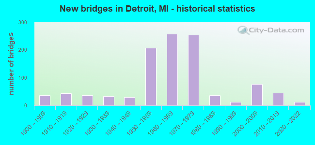
- New bridges - historical statistics
- 1Before 1900
- 371900-1909
- 431910-1919
- 371920-1929
- 331930-1939
- 291940-1949
- 2071950-1959
- 2591960-1969
- 2551970-1979
- 361980-1989
- 131990-1999
- 762000-2009
- 462010-2019
- 132020-2022
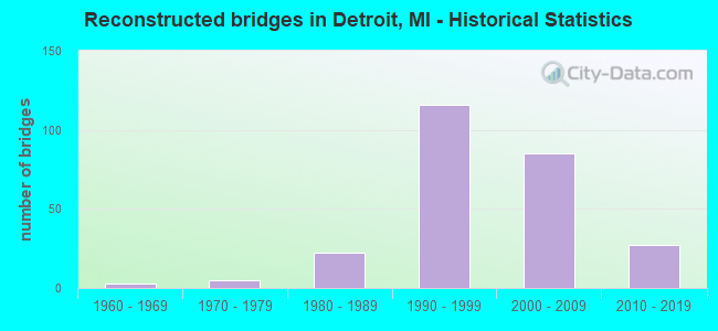
- Reconstructed bridges - Historical Statistics
- 31960-1969
- 51970-1979
- 221980-1989
- 1161990-1999
- 852000-2009
- 272010-2019
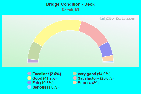
- Bridge Condition - Deck
- 2.5%Excellent
- 14.0%Very good
- 41.7%Good
- 25.6%Satisfactory
- 10.8%Fair
- 4.4%Poor
- 1.0%Serious
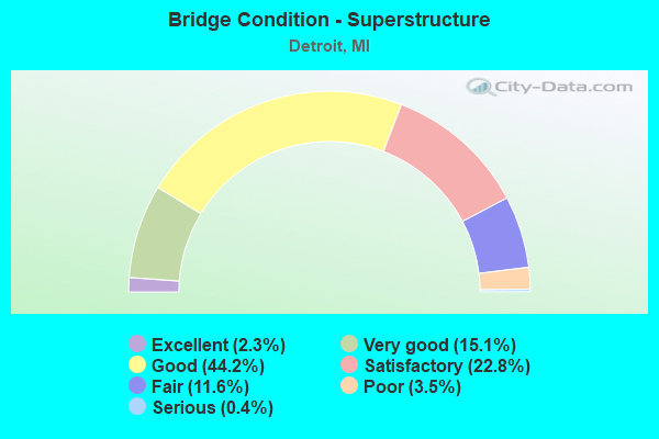
- Bridge Condition - Superstructure
- 2.3%Excellent
- 15.1%Very good
- 44.2%Good
- 22.8%Satisfactory
- 11.6%Fair
- 3.5%Poor
- 0.4%Serious
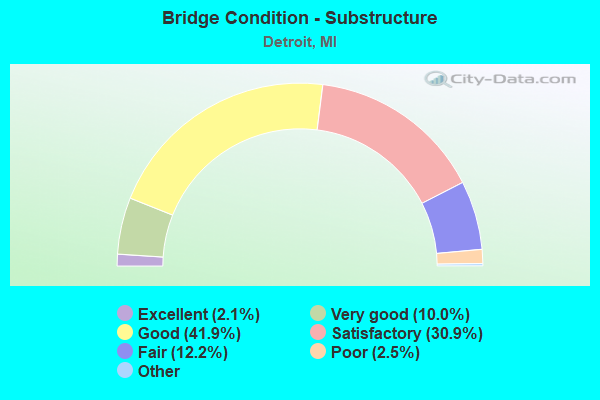
- Bridge Condition - Substructure
- 2.1%Excellent
- 10.0%Very good
- 41.9%Good
- 30.9%Satisfactory
- 12.2%Fair
- 2.5%Poor
- 0.4%Serious
- 0.2%Failed
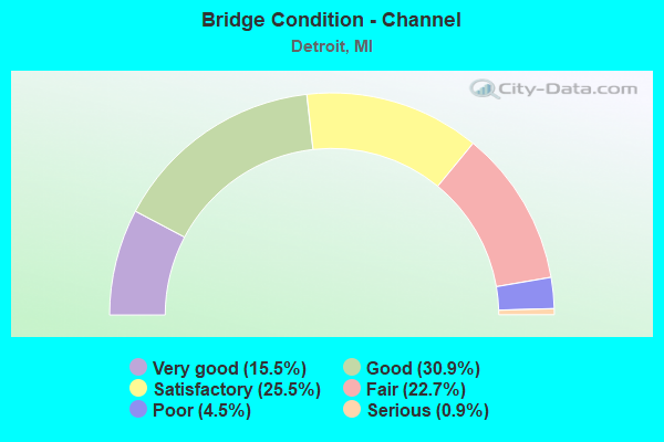
- Bridge Condition - Channel
- 15.5%Very good
- 30.9%Good
- 25.5%Satisfactory
- 22.7%Fair
- 4.5%Poor
- 0.9%Serious
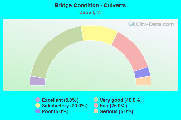
- Bridge Condition - Culverts
- 5.0%Excellent
- 40.0%Very good
- 20.0%Satisfactory
- 25.0%Fair
- 5.0%Poor
- 5.0%Serious
Find on map >> Show street view
Structure Number: 11218, Location: IN DETROIT (Lat: 42.383344, Lng: -83.029839), Route carried "under" structure: Interstate 94, Year Built: 2019, Structure Length: 0. m, Average Daily Traffic: 142,650 (year 2017), Truck Traffic: 5%, Features Intersected: I-94, Facility Carried by Structure: CONCORD AVE
Minimum Vertical Clearance: 4.85m (15.91ft), Kilometerpoint: 48.992, Lanes on structure: 2, Lanes under structure: 6, Material/Design: Prestressed concrete, Design/Construction: Stringer/Multi-beam, Length of Maximum Span: 34.9m (114.5ft)
Find on map >> Show street view
Structure Number: 1122, Location: IN DETROIT (Lat: 42.386153, Lng: -83.020078), Route carried "under" structure: Interstate 94, Year Built: 2013, Structure Length: 0. m, Average Daily Traffic: 147,000 (year 2012), Truck Traffic: 6%, Features Intersected: I-94, Facility Carried by Structure: M-53(VANDYKE ST)
Minimum Vertical Clearance: 5.05m (16.57ft), Kilometerpoint: 49.864, Lanes on structure: 6, Lanes under structure: 6, Material/Design: Prestressed concrete, Design/Construction: Stringer/Multi-beam, Length of Maximum Span: 27.4m (89.9ft)
Find on map >> Show street view
Structure Number: 11222, Location: IN DETROIT (Lat: 42.390858, Lng: -83.008125), Route carried "under" structure: Interstate 94, Year Built: 1957, Structure Length: 0. m, Average Daily Traffic: 157,788 (year 2007), Truck Traffic: 5%, Features Intersected: I-94, Facility Carried by Structure: MCCLELLAN AVE
Minimum Vertical Clearance: 4.98m (16.34ft), Kilometerpoint: 50.978, Lanes on structure: 4, Lanes under structure: 6, Material/Design: Steel, Design/Construction: Stringer/Multi-beam, Length of Maximum Span: 24.5m (80.4ft)
Find on map >> Show street view
Structure Number: 11223, Location: IN DETROIT (Lat: 42.380911, Lng: -83.031942), Route carried "under" structure: Interstate 94, Year Built: 1958, Structure Length: 0. m, Average Daily Traffic: 166,726 (year 2007), Truck Traffic: 5%, Features Intersected: I-94, Facility Carried by Structure: HARPER AVE
Minimum Vertical Clearance: 5.31m (17.42ft), Kilometerpoint: 48.670, Lanes on structure: 2, Lanes under structure: 6, Material/Design: Steel continuous, Design/Construction: Stringer/Multi-beam, Length of Maximum Span: 26.5m (86.9ft)
Find on map >> Show street view
Structure Number: 11224, Location: CITY OF DETROIT (Lat: 42.373922, Lng: -83.048900), Route carried "under" structure: City street 2000, Year Built: 1983, Structure Length: 0. m, Average Daily Traffic: 1,500 (year 1982), Features Intersected: E BD E GRAND BLVD, Facility Carried by Structure: CHENE RAMP TO I-94
Minimum Vertical Clearance: 30+ m (98+ ft), Kilometerpoint: 8.638, Lanes on structure: 2, Lanes under structure: 3, Material/Design: Steel, Design/Construction: Stringer/Multi-beam, Length of Maximum Span: 30.1m (98.8ft)
Find on map >> Show street view
Structure Number: 11225, Location: IN DETROIT (Lat: 42.377111, Lng: -83.038442), Route carried "under" structure: Interstate 94, Year Built: 1983, Structure Length: 0. m, Average Daily Traffic: 154,114 (year 2007), Truck Traffic: 4%, Features Intersected: I-94, Facility Carried by Structure: LUCKY PLACE
Minimum Vertical Clearance: 4.55m (14.93ft), Kilometerpoint: 47.973, Lanes on structure: 2, Lanes under structure: 7, Material/Design: Steel continuous, Design/Construction: Stringer/Multi-beam, Length of Maximum Span: 24.7m (81.0ft)
Find on map >> Show street view
Structure Number: 11226, Location: IN DETROIT (Lat: 42.378547, Lng: -83.034897), Route carried "under" structure: Interstate 94, Year Built: 1983, Structure Length: 0. m, Average Daily Traffic: 154,114 (year 2007), Truck Traffic: 4%, Features Intersected: I-94, Facility Carried by Structure: SAGINAW ST U-TRN
Minimum Vertical Clearance: 5.16m (16.93ft), Kilometerpoint: 48.308, Lanes on structure: 2, Lanes under structure: 7, Material/Design: Steel continuous, Design/Construction: Stringer/Multi-beam, Length of Maximum Span: 24.7m (81.0ft)
Find on map >> Show street view
Structure Number: 11227, Location: IN DETROIT (Lat: 42.381817, Lng: -83.031303), Route carried "under" structure: Interstate 94, Year Built: 1958, Structure Length: 0. m, Average Daily Traffic: 166,726 (year 2007), Truck Traffic: 5%, Features Intersected: I-94, Facility Carried by Structure: CONRAIL
Minimum Vertical Clearance: 4.29m (14.07ft), Kilometerpoint: 48.784, Lanes under structure: 6, Material/Design: Steel, Design/Construction: Stringer/Multi-beam, Length of Maximum Span: 18.2m (59.7ft)
Find on map >> Show street view
Structure Number: 1123, Location: IN DETROIT (Lat: 42.397461, Lng: -82.985933), Route carried "under" structure: Interstate 94, Year Built: 1958, Structure Length: 0. m, Average Daily Traffic: 130,650 (year 2011), Truck Traffic: 6%, Features Intersected: I-94, Facility Carried by Structure: MALCOLM AVE WALKOV
Minimum Vertical Clearance: 5.21m (17.09ft), Kilometerpoint: 53.030, Lanes under structure: 8, Material/Design: Steel, Design/Construction: Girder and Floorbeam System, Length of Maximum Span: 20.4m (66.9ft)
Find on map >> Show street view
Structure Number: 11231, Location: IN DETROIT (Lat: 42.402119, Lng: -82.970072), Route carried "under" structure: Interstate 94, Year Built: 1958, Structure Length: 0. m, Average Daily Traffic: 130,650 (year 2011), Truck Traffic: 6%, Features Intersected: I-94, Facility Carried by Structure: COPLIN AVE WALKOVE
Minimum Vertical Clearance: 4.95m (16.24ft), Kilometerpoint: 54.438, Lanes under structure: 7, Material/Design: Steel, Design/Construction: Girder and Floorbeam System, Length of Maximum Span: 22.2m (72.8ft)
Find on map >> Show street view
Structure Number: 11232, Location: IN DETROIT (Lat: 42.403047, Lng: -82.966594), Route carried "under" structure: Interstate 94, Year Built: 1959, Structure Length: 0. m, Average Daily Traffic: 130,650 (year 2011), Truck Traffic: 6%, Features Intersected: I-94, Facility Carried by Structure: NEWPORT AVE WALKOV
Minimum Vertical Clearance: 4.88m (16.01ft), Kilometerpoint: 54.742, Lanes under structure: 7, Material/Design: Steel, Design/Construction: Girder and Floorbeam System, Length of Maximum Span: 23.1m (75.8ft)
Find on map >> Show street view
Structure Number: 11233, Location: IN DETROIT (Lat: 42.404381, Lng: -82.961997), Route carried "under" structure: Interstate 94, Year Built: 1959, Structure Length: 0. m, Average Daily Traffic: 130,650 (year 2011), Truck Traffic: 6%, Features Intersected: I-94, Facility Carried by Structure: PHILIP AVE WALKOVE
Minimum Vertical Clearance: 4.75m (15.58ft), Kilometerpoint: 55.149, Lanes under structure: 6, Material/Design: Steel, Design/Construction: Girder and Floorbeam System, Length of Maximum Span: 16.6m (54.5ft)
Find on map >> Show street view
Structure Number: 11234, Location: IN DETROIT (Lat: 42.406050, Lng: -82.956558), Route carried "under" structure: Interstate 94, Year Built: 1959, Structure Length: 0. m, Average Daily Traffic: 130,650 (year 2011), Truck Traffic: 6%, Features Intersected: I-94, Facility Carried by Structure: LAKEPOINTE AV WALK
Minimum Vertical Clearance: 4.82m (15.81ft), Kilometerpoint: 55.634, Lanes under structure: 6, Material/Design: Steel, Design/Construction: Girder and Floorbeam System, Length of Maximum Span: 18.2m (59.7ft)
Find on map >> Show street view
Structure Number: 11235, Location: IN DETROIT (Lat: 42.407700, Lng: -82.950672), Route carried "under" structure: Interstate 94, Year Built: 1959, Structure Length: 0. m, Average Daily Traffic: 130,650 (year 2011), Truck Traffic: 6%, Features Intersected: I-94, Facility Carried by Structure: CHATSWORTH RD WALK
Minimum Vertical Clearance: 5.03m (16.50ft), Kilometerpoint: 56.152, Lanes under structure: 6, Material/Design: Steel, Design/Construction: Girder and Floorbeam System, Length of Maximum Span: 17.9m (58.7ft)
Find on map >> Show street view
Structure Number: 11236, Location: IN DETROIT (Lat: 42.409997, Lng: -82.947006), Route carried "under" structure: Interstate 94, Year Built: 1959, Structure Length: 0. m, Average Daily Traffic: 130,650 (year 2011), Truck Traffic: 6%, Features Intersected: I-94, Facility Carried by Structure: BEDFORD RD WALKOVE
Minimum Vertical Clearance: 4.80m (15.75ft), Kilometerpoint: 56.549, Lanes under structure: 6, Material/Design: Steel, Design/Construction: Girder and Floorbeam System, Length of Maximum Span: 16.7m (54.8ft)
Find on map >> Show street view
Structure Number: 11239, Location: IN DETROIT (Lat: 42.415136, Lng: -82.940147), Route carried "under" structure: Interstate 94, Year Built: 1959, Structure Length: 0. m, Average Daily Traffic: 130,650 (year 2011), Truck Traffic: 6%, Features Intersected: I-94, Facility Carried by Structure: BISHOP AVE WALKOVE
Minimum Vertical Clearance: 4.85m (15.91ft), Kilometerpoint: 57.351, Lanes under structure: 6, Material/Design: Steel, Design/Construction: Girder and Floorbeam System, Length of Maximum Span: 21.3m (69.9ft)
Find on map >> Show street view
Structure Number: 11245, Location: IN DETROIT (Lat: 42.391539, Lng: -83.006272), Route carried "under" structure: Interstate 94, Year Built: 2018, Structure Length: 0. m, Average Daily Traffic: 142,650 (year 2017), Truck Traffic: 5%, Features Intersected: I-94, Facility Carried by Structure: M-3 (GRATIOT)
Minimum Vertical Clearance: 4.67m (15.32ft), Kilometerpoint: 51.135, Lanes on structure: 8, Lanes under structure: 8, Material/Design: Prestressed concrete, Design/Construction: Stringer/Multi-beam, Length of Maximum Span: 35.4m (116.1ft)
Find on map >> Show street view
Structure Number: 11247, Location: IN DETROIT (Lat: 42.392269, Lng: -82.995839), Route carried "under" structure: Interstate 94, Year Built: 2019, Structure Length: 0. m, Average Daily Traffic: 142,650 (year 2017), Truck Traffic: 5%, Features Intersected: I-94, Facility Carried by Structure: FRENCH ROAD
Minimum Vertical Clearance: 4.93m (16.17ft), Kilometerpoint: 52.011, Lanes on structure: 2, Lanes under structure: 6, Material/Design: Prestressed concrete, Design/Construction: Stringer/Multi-beam, Length of Maximum Span: 29.1m (95.5ft)
Find on map >> Show street view
Structure Number: 11248, Location: IN DETROIT (Lat: 42.395461, Lng: -82.989086), Route carried "under" structure: Interstate 94, Year Built: 1958, Structure Length: 0. m, Average Daily Traffic: 148,534 (year 2007), Truck Traffic: 6%, Features Intersected: I-94, Facility Carried by Structure: SB CONNER AVE
Minimum Vertical Clearance: 4.65m (15.26ft), Kilometerpoint: 52.684, Lanes on structure: 4, Lanes under structure: 8, Material/Design: Steel, Design/Construction: Stringer/Multi-beam, Length of Maximum Span: 20.7m (67.9ft)
Find on map >> Show street view
Structure Number: 11249, Location: IN DETROIT (Lat: 42.396567, Lng: -82.987589), Route carried "under" structure: Interstate 94, Year Built: 1958, Structure Length: 0. m, Average Daily Traffic: 128,570 (year 2007), Truck Traffic: 6%, Features Intersected: I-94, Facility Carried by Structure: NB CONNER AVE
Minimum Vertical Clearance: 4.52m (14.83ft), Kilometerpoint: 52.858, Lanes on structure: 4, Lanes under structure: 6, Material/Design: Steel, Design/Construction: Stringer/Multi-beam, Length of Maximum Span: 17.3m (56.8ft)
Find on map >> Show street view
Structure Number: 1125, Location: IN DETROIT (Lat: 42.398414, Lng: -82.984003), Route carried "under" structure: Interstate 94, Year Built: 1958, Structure Length: 0. m, Average Daily Traffic: 130,650 (year 2011), Truck Traffic: 6%, Features Intersected: I-94, Facility Carried by Structure: BARRETT AVE
Minimum Vertical Clearance: 4.65m (15.26ft), Kilometerpoint: 53.220, Lanes on structure: 2, Lanes under structure: 6, Material/Design: Steel, Design/Construction: Stringer/Multi-beam, Length of Maximum Span: 17.3m (56.8ft)
Find on map >> Show street view
Structure Number: 11251, Location: IN DETROIT (Lat: 42.401467, Lng: -82.973028), Route carried "under" structure: Interstate 94, Year Built: 1958, Structure Length: 0. m, Average Daily Traffic: 130,650 (year 2011), Truck Traffic: 6%, Features Intersected: I-94, Facility Carried by Structure: DICKERSON AVE
Minimum Vertical Clearance: 4.37m (14.34ft), Kilometerpoint: 54.184, Lanes on structure: 4, Lanes under structure: 6, Material/Design: Steel, Design/Construction: Stringer/Multi-beam, Length of Maximum Span: 16.7m (54.8ft)
Find on map >> Show street view
Structure Number: 11252, Location: IN DETROIT (Lat: 42.403706, Lng: -82.964214), Route carried "under" structure: Interstate 94, Year Built: 1958, Structure Length: 0. m, Average Daily Traffic: 130,650 (year 2011), Truck Traffic: 7%, Features Intersected: I-94, Facility Carried by Structure: CHALMERS AVE
Minimum Vertical Clearance: 4.50m (14.76ft), Kilometerpoint: 54.951, Lanes on structure: 4, Lanes under structure: 6, Material/Design: Steel, Design/Construction: Stringer/Multi-beam, Length of Maximum Span: 16.7m (54.8ft)
Find on map >> Show street view
Structure Number: 11253, Location: IN DETROIT (Lat: 42.405008, Lng: -82.959967), Route carried "under" structure: Interstate 94, Year Built: 1959, Structure Length: 0. m, Average Daily Traffic: 130,650 (year 2011), Truck Traffic: 6%, Features Intersected: I-94, Facility Carried by Structure: OUTER DRIVE NB
Minimum Vertical Clearance: 4.40m (14.44ft), Kilometerpoint: 55.330, Lanes on structure: 4, Lanes under structure: 6, Material/Design: Steel, Design/Construction: Stringer/Multi-beam, Length of Maximum Span: 16.7m (54.8ft)
Find on map >> Show street view
Structure Number: 11254, Location: IN DETROIT (Lat: 42.404925, Lng: -82.960242), Route carried "under" structure: Interstate 94, Year Built: 1959, Structure Length: 0. m, Average Daily Traffic: 130,650 (year 2011), Truck Traffic: 6%, Features Intersected: I-94, Facility Carried by Structure: OUTER DRIVE SB
Minimum Vertical Clearance: 4.40m (14.44ft), Kilometerpoint: 55.305, Lanes on structure: 4, Lanes under structure: 6, Material/Design: Steel, Design/Construction: Stringer/Multi-beam, Length of Maximum Span: 16.7m (54.8ft)
Find on map >> Show street view
Structure Number: 11255, Location: IN DETROIT (Lat: 42.406761, Lng: -82.953953), Route carried "under" structure: Interstate 94, Year Built: 1958, Structure Length: 0. m, Average Daily Traffic: 130,650 (year 2011), Truck Traffic: 6%, Features Intersected: I-94, Facility Carried by Structure: NOTTINGHAM RD
Minimum Vertical Clearance: 4.52m (14.83ft), Kilometerpoint: 55.862, Lanes on structure: 2, Lanes under structure: 6, Material/Design: Steel, Design/Construction: Stringer/Multi-beam, Length of Maximum Span: 16.7m (54.8ft)
Find on map >> Show street view
Structure Number: 11256, Location: IN DETROIT (Lat: 42.409092, Lng: -82.948208), Route carried "under" structure: Interstate 94, Year Built: 1959, Structure Length: 0. m, Average Daily Traffic: 130,650 (year 2011), Truck Traffic: 6%, Features Intersected: I-94, Facility Carried by Structure: HARPER AVE
Minimum Vertical Clearance: 4.82m (15.81ft), Kilometerpoint: 56.408, Lanes on structure: 4, Lanes under structure: 6, Material/Design: Steel, Design/Construction: Stringer/Multi-beam, Length of Maximum Span: 27.4m (89.9ft)
Find on map >> Show street view
Structure Number: 11257, Location: IN DETROIT (Lat: 42.412861, Lng: -82.943211), Route carried "under" structure: Interstate 94, Year Built: 1959, Structure Length: 0. m, Average Daily Traffic: 130,650 (year 2011), Truck Traffic: 6%, Features Intersected: I-94, Facility Carried by Structure: WHITTIER RD
Minimum Vertical Clearance: 4.37m (14.34ft), Kilometerpoint: 56.995, Lanes on structure: 4, Lanes under structure: 6, Material/Design: Steel, Design/Construction: Stringer/Multi-beam, Length of Maximum Span: 17.3m (56.8ft)
Find on map >> Show street view
Structure Number: 11258, Location: IN DETROIT (Lat: 42.417208, Lng: -82.937139), Route carried "under" structure: Interstate 94, Year Built: 1959, Structure Length: 0. m, Average Daily Traffic: 130,650 (year 2011), Truck Traffic: 6%, Features Intersected: I-94, Facility Carried by Structure: CADIEUX AVE
Minimum Vertical Clearance: 4.72m (15.49ft), Kilometerpoint: 57.691, Lanes on structure: 4, Lanes under structure: 6, Material/Design: Steel, Design/Construction: Stringer/Multi-beam, Length of Maximum Span: 17.0m (55.8ft)
Find on map >> Show street view
Structure Number: 11259, Location: IN DETROIT (Lat: 42.419250, Lng: -82.933450), Route carried "under" structure: Interstate 94, Year Built: 1959, Structure Length: 0. m, Average Daily Traffic: 130,650 (year 2011), Truck Traffic: 7%, Features Intersected: I-94, Facility Carried by Structure: MORANG AVE
Minimum Vertical Clearance: 4.47m (14.67ft), Kilometerpoint: 58.069, Lanes on structure: 4, Lanes under structure: 6, Material/Design: Steel, Design/Construction: Stringer/Multi-beam, Length of Maximum Span: 16.7m (54.8ft)
Find on map >> Show street view
Structure Number: 1126, Location: IN DETROIT (Lat: 42.420308, Lng: -82.932122), Route carried "under" structure: Interstate 94, Year Built: 1959, Structure Length: 0. m, Average Daily Traffic: 130,650 (year 2011), Truck Traffic: 6%, Features Intersected: I-94, Facility Carried by Structure: HARPER AVE
Minimum Vertical Clearance: 4.80m (15.75ft), Kilometerpoint: 58.230, Lanes on structure: 2, Lanes under structure: 6, Material/Design: Steel, Design/Construction: Stringer/Multi-beam, Length of Maximum Span: 24.0m (78.7ft)
Find on map >> Show street view
Structure Number: 11261, Location: IN DETROIT (Lat: 42.424764, Lng: -82.928442), Route carried "under" structure: Interstate 94, Year Built: 2003, Structure Length: 0. m, Average Daily Traffic: 130,650 (year 2011), Truck Traffic: 6%, Features Intersected: I-94, Facility Carried by Structure: MOROSS RD NB
Minimum Vertical Clearance: 4.52m (14.83ft), Kilometerpoint: 58.801, Lanes on structure: 4, Lanes under structure: 6, Material/Design: Prestressed concrete, Design/Construction: Box Beam or Girders - Multiple, Length of Maximum Span: 24.9m (81.7ft)
Find on map >> Show street view
Structure Number: 11262, Location: IN DETROIT (Lat: 42.424386, Lng: -82.928739), Route carried "under" structure: Interstate 94, Year Built: 2003, Structure Length: 0. m, Average Daily Traffic: 130,650 (year 2011), Truck Traffic: 6%, Features Intersected: I-94, Facility Carried by Structure: MOROSS RD SB
Minimum Vertical Clearance: 4.52m (14.83ft), Kilometerpoint: 58.762, Lanes on structure: 4, Lanes under structure: 6, Material/Design: Prestressed concrete, Design/Construction: Box Beam or Girders - Multiple, Length of Maximum Span: 24.9m (81.7ft)
Find on map >> Show street view
Structure Number: 1127, Location: IN DETROIT (Lat: 42.393528, Lng: -82.991889), Route carried "under" structure: Interstate 94, Year Built: 1959, Structure Length: 0. m, Average Daily Traffic: 148,534 (year 2007), Truck Traffic: 5%, Features Intersected: I-94, Facility Carried by Structure: CR RR
Minimum Vertical Clearance: 5.05m (16.57ft), Kilometerpoint: 52.368, Lanes under structure: 6, Material/Design: Steel, Design/Construction: Stringer/Multi-beam, Length of Maximum Span: 19.8m (65.0ft)
Find on map >> Show street view
Structure Number: 11271, Location: IN DETROIT (Lat: 42.393631, Lng: -82.991703), Route carried "under" structure: Interstate 94, Year Built: 1959, Structure Length: 0. m, Average Daily Traffic: 148,534 (year 2007), Truck Traffic: 5%, Features Intersected: I-94, Facility Carried by Structure: CR RR SPUR BR(ABN)
Minimum Vertical Clearance: 5.05m (16.57ft), Kilometerpoint: 52.388, Lanes under structure: 6, Material/Design: Steel, Design/Construction: Stringer/Multi-beam, Length of Maximum Span: 19.5m (64.0ft)
Find on map >> Show street view
Structure Number: 11316, Location: IN DETROIT (Lat: 42.331147, Lng: -83.101242), Route carried "under" structure: US 12, Year Built: 1941, Structure Length: 0. m, Average Daily Traffic: 12,118 (year 2007), Truck Traffic: 9%, Features Intersected: US-12, Facility Carried by Structure: SCOTTEN AVE
Minimum Vertical Clearance: 4.34m (14.24ft), Kilometerpoint: 7.632, Lanes on structure: 4, Lanes under structure: 8, Material/Design: Steel, Design/Construction: Girder and Floorbeam System, Length of Maximum Span: 21.9m (71.9ft)
Find on map >> Show street view
Structure Number: 11319, Location: IN DETROIT (Lat: 42.331294, Lng: -83.102817), Route carried "under" structure: US 12, Year Built: 1941, Structure Length: 0. m, Average Daily Traffic: 12,118 (year 2007), Truck Traffic: 9%, Features Intersected: US-12, Facility Carried by Structure: CONRAIL
Minimum Vertical Clearance: 4.29m (14.07ft), Kilometerpoint: 7.492, Lanes under structure: 8, Material/Design: Steel, Design/Construction: Girder and Floorbeam System, Length of Maximum Span: 22.8m (74.8ft)
Find on map >> Show street view
Structure Number: 1132, Location: IN DETROIT @ SCOTTEN 4000 (Lat: 42.331164, Lng: -83.099461), Route carried "under" structure: US 12, Year Built: 1941, Structure Length: 0. m, Average Daily Traffic: 12,118 (year 2007), Truck Traffic: 9%, Features Intersected: US-12, Facility Carried by Structure: CONRAIL
Minimum Vertical Clearance: 4.29m (14.07ft), Kilometerpoint: 7.778, Lanes under structure: 8, Material/Design: Steel, Design/Construction: Girder and Floorbeam System, Length of Maximum Span: 23.1m (75.8ft)
Find on map >> Show street view
Structure Number: 11377, Location: IN DETROIT O S SERVICE RD (Lat: 42.407103, Lng: -83.083917), Route carried "under" structure: ServiceState highway 8, Year Built: 1971, Structure Length: 0. m, Average Daily Traffic: 7,500 (year 0000), Truck Traffic: 5%, Features Intersected: S SERVICE DRIVE, M-8
Minimum Vertical Clearance: 4.62m (15.16ft), Kilometerpoint: 0.137, Lanes on structure: 3, Lanes under structure: 2, Material/Design: Steel, Design/Construction: Stringer/Multi-beam, Length of Maximum Span: 31.6m (103.7ft)
Find on map >> Show street view
Structure Number: 11378, Location: IN DETROIT M-8 WB RAMP (Lat: 42.408236, Lng: -83.083486), Route carried "under" structure: Ramp State highway 8, Year Built: 1971, Structure Length: 0. m, Average Daily Traffic: 18,900 (year 0000), Features Intersected: I-75 RAMP TO WB M-8, Facility Carried by Structure: N SERVICE RD
Minimum Vertical Clearance: 4.47m (14.67ft), Kilometerpoint: 0.571, Lanes on structure: 2, Lanes under structure: 2, Material/Design: Steel, Design/Construction: Stringer/Multi-beam, Length of Maximum Span: 37.2m (122.0ft)
Find on map >> Show street view
Structure Number: 11379, Location: IN DETROIT (Lat: 42.413131, Lng: -83.068839), Route carried "under" structure: State highway 8, Year Built: 1971, Structure Length: 0. m, Average Daily Traffic: 37,076 (year 2007), Truck Traffic: 4%, Features Intersected: M-8, Facility Carried by Structure: JOSEPH CAMPAU
Minimum Vertical Clearance: 5.31m (17.42ft), Kilometerpoint: 8.174, Lanes on structure: 4, Lanes under structure: 8, Material/Design: Steel continuous, Design/Construction: Stringer/Multi-beam, Length of Maximum Span: 25.9m (85.0ft)
Find on map >> Show street view
Structure Number: 1138, Location: IN DETROIT (Lat: 42.410767, Lng: -83.072833), Route carried "under" structure: State highway 8, Year Built: 1971, Structure Length: 0. m, Average Daily Traffic: 37,076 (year 2007), Truck Traffic: 4%, Features Intersected: M-8, Facility Carried by Structure: GODDARD AVENUE
Minimum Vertical Clearance: 4.42m (14.50ft), Kilometerpoint: 7.752, Lanes on structure: 2, Lanes under structure: 10, Material/Design: Steel, Design/Construction: Stringer/Multi-beam, Length of Maximum Span: 39.9m (130.9ft)
Find on map >> Show street view
Structure Number: 11383, Location: IN DETROIT (Lat: 42.330153, Lng: -83.059461), Route carried "under" structure: State highway 10, Year Built: 1954, Structure Length: 0. m, Average Daily Traffic: 74,300 (year 2007), Truck Traffic: 1%, Features Intersected: M-10, Facility Carried by Structure: PORTER ST WALKOVER
Minimum Vertical Clearance: 5.31m (17.42ft), Kilometerpoint: 18.885, Lanes under structure: 7, Material/Design: Steel, Design/Construction: Girder and Floorbeam System, Length of Maximum Span: 29.8m (97.8ft)
Find on map >> Show street view
Structure Number: 11386, Location: IN DETROIT (Lat: 42.345894, Lng: -83.069183), Route carried "under" structure: State highway 10, Year Built: 1953, Structure Length: 0. m, Average Daily Traffic: 111,518 (year 2007), Truck Traffic: 2%, Features Intersected: M-10, Facility Carried by Structure: SELDEN AVE WALKOVE
Minimum Vertical Clearance: 4.62m (15.16ft), Kilometerpoint: 16.926, Lanes under structure: 6, Material/Design: Steel, Design/Construction: Girder and Floorbeam System, Length of Maximum Span: 19.2m (63.0ft)
Find on map >> Show street view
Structure Number: 11387, Location: IN DETROIT (Lat: 42.349461, Lng: -83.070881), Route carried "under" structure: State highway 10, Year Built: 1953, Structure Length: 0. m, Average Daily Traffic: 111,518 (year 2007), Truck Traffic: 2%, Features Intersected: M-10, Facility Carried by Structure: CANFIELD AV WALKOV
Minimum Vertical Clearance: 4.78m (15.68ft), Kilometerpoint: 16.504, Lanes under structure: 7, Material/Design: Steel, Design/Construction: Girder and Floorbeam System, Length of Maximum Span: 22.5m (73.8ft)
Find on map >> Show street view
Structure Number: 11388, Location: IN DETROIT (Lat: 42.355550, Lng: -83.074350), Route carried "under" structure: State highway 10, Year Built: 1953, Structure Length: 0. m, Average Daily Traffic: 129,400 (year 2007), Truck Traffic: 2%, Features Intersected: M-10, Facility Carried by Structure: MERRICK AVE WALKOV
Minimum Vertical Clearance: 5.77m (18.93ft), Kilometerpoint: 15.772, Lanes under structure: 8, Material/Design: Steel, Design/Construction: Girder and Floorbeam System, Length of Maximum Span: 23.4m (76.8ft)
Find on map >> Show street view
Structure Number: 11389, Location: IN DETROIT (Lat: 42.326475, Lng: -83.052503), Route carried "under" structure: State highway 10, Year Built: 1980, Structure Length: 0. m, Average Daily Traffic: 74,078 (year 2007), Truck Traffic: 1%, Features Intersected: M-10 JOHN LODGE FRWY, Facility Carried by Structure: JOE L WALKWAY
Minimum Vertical Clearance: 6.10m (20.01ft), Kilometerpoint: 19.601, Lanes under structure: 8, Material/Design: Steel, Design/Construction: Box Beam or Girders - Single/Spread, Length of Maximum Span: 30.4m (99.7ft)
Find on map >> Show street view
Structure Number: 1139, Location: IN DETROIT (Lat: 42.336706, Lng: -83.038397), Route carried "under" structure: Interstate 375, Year Built: 1959, Structure Length: 0. m, Average Daily Traffic: 48,074 (year 2007), Truck Traffic: 1%, Features Intersected: I-375, Facility Carried by Structure: MONROE AVE
Minimum Vertical Clearance: 4.52m (14.83ft), Kilometerpoint: 1.112, Lanes on structure: 2, Lanes under structure: 6, Material/Design: Prestressed concrete, Design/Construction: Box Beam or Girders - Single/Spread, Length of Maximum Span: 19.2m (63.0ft)
Find on map >> Show street view
Structure Number: 11391, Location: IN DETROIT (Lat: 42.335675, Lng: -83.037733), Route carried "under" structure: Interstate 375, Year Built: 1960, Structure Length: 0. m, Average Daily Traffic: 48,074 (year 2007), Truck Traffic: 2%, Features Intersected: I-375, Facility Carried by Structure: LAFAYETTE AVE
Minimum Vertical Clearance: 4.44m (14.57ft), Kilometerpoint: 1.001, Lanes on structure: 6, Lanes under structure: 6, Material/Design: Prestressed concrete, Design/Construction: Stringer/Multi-beam, Length of Maximum Span: 19.2m (63.0ft)
Find on map >> Show street view
Structure Number: 11392, Location: IN DETROIT (Lat: 42.333347, Lng: -83.036158), Route carried "under" structure: Interstate 375, Year Built: 1960, Structure Length: 0. m, Average Daily Traffic: 48,856 (year 2003), Truck Traffic: 2%, Features Intersected: I-375, Facility Carried by Structure: LARNED ST
Minimum Vertical Clearance: 4.70m (15.42ft), Kilometerpoint: 0.715, Lanes on structure: 5, Lanes under structure: 4, Material/Design: Steel, Design/Construction: Stringer/Multi-beam, Length of Maximum Span: 16.2m (53.1ft)
Find on map >> Show street view
Structure Number: 11393, Location: IN DETROIT (Lat: 42.332592, Lng: -83.035886), Route carried "under" structure: Interstate 375, Year Built: 1962, Structure Length: 0. m, Average Daily Traffic: 18,762 (year 2007), Truck Traffic: 5%, Features Intersected: I-375, Facility Carried by Structure: JEFFERSON AVE
Minimum Vertical Clearance: 5.11m (16.77ft), Kilometerpoint: 0.608, Lanes on structure: 4, Lanes under structure: 4, Material/Design: Steel, Design/Construction: Stringer/Multi-beam, Length of Maximum Span: 21.6m (70.9ft)
Find on map >> Show street view
Structure Number: 11394, Location: IN DETROIT (Lat: 42.332258, Lng: -83.035994), Route carried "under" structure: Interstate 375, Year Built: 1962, Structure Length: 0. m, Average Daily Traffic: 18,762 (year 2007), Truck Traffic: 5%, Features Intersected: I-375, Facility Carried by Structure: CHRYSLER DR
Minimum Vertical Clearance: 5.00m (16.40ft), Kilometerpoint: 0.570, Lanes on structure: 4, Lanes under structure: 4, Material/Design: Steel, Design/Construction: Stringer/Multi-beam, Length of Maximum Span: 17.0m (55.8ft)
Find on map >> Show street view
Structure Number: 11395, Location: IN DETROIT (Lat: 42.327158, Lng: -83.047847), Route carried "under" structure: State highway 10, Year Built: 1958, Structure Length: 0. m, Average Daily Traffic: 74,078 (year 2007), Truck Traffic: 1%, Features Intersected: M-10, Facility Carried by Structure: WASHINGTON ST
Minimum Vertical Clearance: 4.72m (15.49ft), Kilometerpoint: 20.037, Lanes on structure: 6, Lanes under structure: 6, Material/Design: Steel continuous, Design/Construction: Stringer/Multi-beam, Length of Maximum Span: 15.8m (51.8ft)
Find on map >> Show street view
Structure Number: 11396, Location: IN DETROIT (Lat: 42.326439, Lng: -83.051972), Route carried "under" structure: State highway 10, Year Built: 1959, Structure Length: 0. m, Average Daily Traffic: 37,039 (year 2007), Truck Traffic: 1%, Features Intersected: M-10 NB, Facility Carried by Structure: LARNED ST RAMP
Minimum Vertical Clearance: 4.37m (14.34ft), Kilometerpoint: 19.659, Lanes on structure: 1, Lanes under structure: 2, Material/Design: Prestressed concrete, Design/Construction: Slab, Length of Maximum Span: 31.1m (102.0ft)
Find on map >> Show street view
Structure Number: 11397, Location: IN DETROIT (Lat: 42.327200, Lng: -83.055556), Route carried "under" structure: State highway 10, Year Built: 1958, Structure Length: 0. m, Average Daily Traffic: 74,300 (year 2007), Truck Traffic: 1%, Features Intersected: M-10, Facility Carried by Structure: M-85 (FORT ST,)
Minimum Vertical Clearance: 4.60m (15.09ft), Kilometerpoint: 19.345, Lanes on structure: 6, Lanes under structure: 6, Material/Design: Steel continuous, Design/Construction: Stringer/Multi-beam, Length of Maximum Span: 16.7m (54.8ft)
Find on map >> Show street view
Structure Number: 11398, Location: IN DETROIT (Lat: 42.327886, Lng: -83.056658), Route carried "under" structure: State highway 10, Year Built: 1952, Structure Length: 0. m, Average Daily Traffic: 74,300 (year 2007), Truck Traffic: 1%, Features Intersected: M-10, Facility Carried by Structure: LAFAYETTE BLVD
Minimum Vertical Clearance: 4.75m (15.58ft), Kilometerpoint: 19.224, Lanes on structure: 4, Lanes under structure: 6, Material/Design: Steel continuous, Design/Construction: Stringer/Multi-beam, Length of Maximum Span: 17.8m (58.4ft)
Find on map >> Show street view
Structure Number: 11399, Location: IN DETROIT (Lat: 42.328564, Lng: -83.057661), Route carried "under" structure: State highway 10, Year Built: 1953, Structure Length: 0. m, Average Daily Traffic: 74,300 (year 2007), Truck Traffic: 1%, Features Intersected: M-10, Facility Carried by Structure: HOWARD ST
Minimum Vertical Clearance: 4.62m (15.16ft), Kilometerpoint: 19.112, Lanes on structure: 3, Lanes under structure: 6, Material/Design: Steel continuous, Design/Construction: Stringer/Multi-beam, Length of Maximum Span: 18.0m (59.1ft)
Find on map >> Show street view
Structure Number: 114, Location: IN DETROIT (Lat: 42.331586, Lng: -83.061181), Route carried "under" structure: State highway 10, Year Built: 1954, Structure Length: 0. m, Average Daily Traffic: 52,258 (year 2007), Truck Traffic: 1%, Features Intersected: M-10 NB, Facility Carried by Structure: US-12
Minimum Vertical Clearance: 4.65m (15.26ft), Kilometerpoint: 18.672, Lanes on structure: 9, Lanes under structure: 3, Material/Design: Prestressed concrete, Design/Construction: Box Beam or Girders - Multiple, Length of Maximum Span: 19.4m (63.6ft)
Find on map >> Show street view
Structure Number: 11401, Location: IN DETROIT (Lat: 42.331550, Lng: -83.061883), Route carried "under" structure: State highway 10, Year Built: 1954, Structure Length: 0. m, Average Daily Traffic: 52,258 (year 2007), Truck Traffic: 1%, Features Intersected: M-10 SB, Facility Carried by Structure: US-12
Minimum Vertical Clearance: 4.78m (15.68ft), Kilometerpoint: 18.637, Lanes on structure: 9, Lanes under structure: 3, Material/Design: Prestressed concrete, Design/Construction: Box Beam or Girders - Multiple, Length of Maximum Span: 20.0m (65.6ft)
Find on map >> Show street view
Structure Number: 11402, Location: IN DETROIT (Lat: 42.331850, Lng: -83.061481), Route carried "under" structure: State highway 10, Year Built: 1954, Structure Length: 0. m, Average Daily Traffic: 104,516 (year 2007), Truck Traffic: 1%, Features Intersected: M-10, Facility Carried by Structure: BAGLEY AV RAMPS
Minimum Vertical Clearance: 4.34m (14.24ft), Kilometerpoint: 18.634, Lanes on structure: 4, Lanes under structure: 3, Material/Design: Steel, Design/Construction: Stringer/Multi-beam, Length of Maximum Span: 23.7m (77.8ft)
Find on map >> Show street view
Structure Number: 11403, Location: IN DETROIT (Lat: 42.339167, Lng: -83.066114), Route carried "under" structure: State highway 10, Year Built: 1953, Structure Length: 0. m, Average Daily Traffic: 111,518 (year 2007), Truck Traffic: 2%, Features Intersected: M-10, Facility Carried by Structure: GRAND RIVER AVE
Minimum Vertical Clearance: 4.34m (14.24ft), Kilometerpoint: 17.671, Lanes on structure: 10, Lanes under structure: 6, Material/Design: Steel continuous, Design/Construction: Stringer/Multi-beam, Length of Maximum Span: 24.7m (81.0ft)
Find on map >> Show street view
Structure Number: 11404, Location: IN DETROIT (Lat: 42.343225, Lng: -83.068011), Route carried "under" structure: State highway 10, Year Built: 2017, Structure Length: 0. m, Average Daily Traffic: 98,775 (year 2018), Truck Traffic: 2%, Features Intersected: M-10, Facility Carried by Structure: MLK JR BLVD EB
Minimum Vertical Clearance: 4.57m (14.99ft), Kilometerpoint: 17.222, Lanes on structure: 2, Lanes under structure: 7, Material/Design: Prestressed concrete, Design/Construction: Box Beam or Girders - Single/Spread, Length of Maximum Span: 22.7m (74.5ft)
Find on map >> Show street view
Structure Number: 11405, Location: IN DETROIT (Lat: 42.351625, Lng: -83.072083), Route carried "under" structure: State highway 10, Year Built: 1950, Structure Length: 0. m, Average Daily Traffic: 129,400 (year 2007), Truck Traffic: 2%, Features Intersected: M-10, Facility Carried by Structure: FOREST AVE
Minimum Vertical Clearance: 4.37m (14.34ft), Kilometerpoint: 16.247, Lanes on structure: 6, Lanes under structure: 6, Material/Design: Steel continuous, Design/Construction: Stringer/Multi-beam, Length of Maximum Span: 16.7m (54.8ft)
Find on map >> Show street view
Structure Number: 11406, Location: IN DETROIT (Lat: 42.353769, Lng: -83.073392), Route carried "under" structure: State highway 10, Year Built: 1950, Structure Length: 0. m, Average Daily Traffic: 129,400 (year 2007), Truck Traffic: 1%, Features Intersected: M-10, Facility Carried by Structure: WARREN AV
Minimum Vertical Clearance: 4.34m (14.24ft), Kilometerpoint: 15.967, Lanes on structure: 10, Lanes under structure: 8, Material/Design: Steel continuous, Design/Construction: Stringer/Multi-beam, Length of Maximum Span: 18.6m (61.0ft)
Find on map >> Show street view
Structure Number: 11407, Location: IN CITY OF DETROIT (Lat: 42.325717, Lng: -83.053119), Route carried "under" structure: City street 82, Year Built: 1980, Structure Length: 0. m, Average Daily Traffic: 7,500 (year 1988), Truck Traffic: 2%, Features Intersected: JEFFERSON AVE, Facility Carried by Structure: RAMP FROM M-10
Minimum Vertical Clearance: 5.28m (17.32ft), Kilometerpoint: 3.304, Lanes on structure: 2, Lanes under structure: 5, Material/Design: Steel, Design/Construction: Stringer/Multi-beam, Length of Maximum Span: 33.2m (108.9ft)
Find on map >> Show street view
Structure Number: 11408, Location: IN CITY OF DETROIT (Lat: 42.326178, Lng: -83.052139), Route carried "under" structure: City street 2057, Year Built: 1987, Structure Length: 0. m, Average Daily Traffic: 31,500 (year 1993), Features Intersected: WB JEFFERSON AVE, Facility Carried by Structure: M-10 SB
Minimum Vertical Clearance: 4.37m (14.34ft), Kilometerpoint: 3.397, Lanes on structure: 2, Lanes under structure: 2, Material/Design: Prestressed concrete, Design/Construction: Slab, Length of Maximum Span: 25.0m (82.0ft)
Find on map >> Show street view
Structure Number: 11409, Location: IN DETROIT (Lat: 42.326928, Lng: -83.054936), Route carried "under" structure: State highway 10, Year Built: 1950, Structure Length: 0. m, Average Daily Traffic: 74,078 (year 2007), Truck Traffic: 3%, Features Intersected: M-10, Facility Carried by Structure: W C C C RR (ABN)
Minimum Vertical Clearance: 4.55m (14.93ft), Kilometerpoint: 19.437, Lanes under structure: 6, Material/Design: Steel continuous, Design/Construction: Stringer/Multi-beam, Length of Maximum Span: 18.2m (59.7ft)
Find on map >> Show street view
Structure Number: 1141, Location: IN DETROIT (Lat: 42.327017, Lng: -83.055214), Route carried "under" structure: State highway 10, Year Built: 1950, Structure Length: 0. m, Average Daily Traffic: 74,078 (year 2007), Truck Traffic: 3%, Features Intersected: M-10, Facility Carried by Structure: RR PARK'GDECK(ABN)
Minimum Vertical Clearance: 4.55m (14.93ft), Kilometerpoint: 19.398, Lanes under structure: 6, Material/Design: Steel continuous, Design/Construction: Stringer/Multi-beam, Length of Maximum Span: 18.6m (61.0ft)
Find on map >> Show street view
Structure Number: 11412, Location: IN DETROIT (Lat: 42.363078, Lng: -83.078708), Route carried "under" structure: State highway 10, Year Built: 1950, Structure Length: 0. m, Average Daily Traffic: 126,308 (year 2007), Truck Traffic: 2%, Features Intersected: M-10, Facility Carried by Structure: HOLDEN AVE WALKOVE
Minimum Vertical Clearance: 4.39m (14.40ft), Kilometerpoint: 14.863, Lanes under structure: 8, Material/Design: Steel, Design/Construction: Girder and Floorbeam System, Length of Maximum Span: 23.4m (76.8ft)
Find on map >> Show street view
Structure Number: 11413, Location: IN DETROIT (Lat: 42.375747, Lng: -83.087511), Route carried "under" structure: State highway 10, Year Built: 1955, Structure Length: 0. m, Average Daily Traffic: 126,934 (year 2007), Truck Traffic: 2%, Features Intersected: M-10, Facility Carried by Structure: PINGREE AV WALKOVE
Minimum Vertical Clearance: 4.75m (15.58ft), Kilometerpoint: 13.281, Lanes under structure: 8, Material/Design: Prestressed concrete, Design/Construction: Box Beam or Girders - Multiple, Length of Maximum Span: 21.0m (68.9ft)
Find on map >> Show street view
Structure Number: 11414, Location: IN DETROIT (Lat: 42.377186, Lng: -83.088492), Route carried "under" structure: State highway 10, Year Built: 1955, Structure Length: 0. m, Average Daily Traffic: 126,934 (year 2007), Truck Traffic: 2%, Features Intersected: M-10, Facility Carried by Structure: GLADSTONE AVE WALK
Minimum Vertical Clearance: 5.72m (18.77ft), Kilometerpoint: 13.102, Lanes under structure: 9, Material/Design: Steel continuous, Design/Construction: Girder and Floorbeam System, Length of Maximum Span: 26.2m (86.0ft)
Find on map >> Show street view
Structure Number: 11415, Location: IN DETROIT (Lat: 42.390611, Lng: -83.104081), Route carried "under" structure: State highway 10, Year Built: 1955, Structure Length: 0. m, Average Daily Traffic: 134,688 (year 2007), Truck Traffic: 2%, Features Intersected: M-10, Facility Carried by Structure: MONTEREY AV WALKOV
Minimum Vertical Clearance: 4.90m (16.08ft), Kilometerpoint: 11.053, Lanes under structure: 7, Material/Design: Steel, Design/Construction: Frame, Length of Maximum Span: 41.3m (135.5ft)
Find on map >> Show street view
Structure Number: 11416, Location: IN DETROIT (Lat: 42.392653, Lng: -83.105578), Route carried "under" structure: State highway 10, Year Built: 1955, Structure Length: 0. m, Average Daily Traffic: 134,688 (year 2007), Truck Traffic: 2%, Features Intersected: M-10, Facility Carried by Structure: HIGHLAND AV WALKOV
Minimum Vertical Clearance: 4.52m (14.83ft), Kilometerpoint: 10.796, Lanes under structure: 6, Material/Design: Steel, Design/Construction: Frame, Length of Maximum Span: 43.0m (141.1ft)
Find on map >> Show street view
Structure Number: 11417, Location: IN DETROIT (Lat: 42.400253, Lng: -83.113219), Route carried "under" structure: State highway 10, Year Built: 2006, Structure Length: 0. m, Average Daily Traffic: 156,084 (year 2007), Truck Traffic: 2%, Features Intersected: M-10, Facility Carried by Structure: FORD AVE WALKOVER
Minimum Vertical Clearance: 5.44m (17.85ft), Kilometerpoint: 9.743, Lanes under structure: 7, Material/Design: Steel continuous, Design/Construction: Girder and Floorbeam System, Length of Maximum Span: 29.3m (96.1ft)
Find on map >> Show street view
Structure Number: 11418, Location: IN DETROIT (Lat: 42.404628, Lng: -83.120939), Route carried "under" structure: State highway 10, Year Built: 1956, Structure Length: 0. m, Average Daily Traffic: 156,084 (year 2007), Truck Traffic: 2%, Features Intersected: M-10, Facility Carried by Structure: LOG CABIN AV WALKO
Minimum Vertical Clearance: 5.36m (17.59ft), Kilometerpoint: 8.942, Lanes under structure: 7, Material/Design: Steel continuous, Design/Construction: Girder and Floorbeam System, Length of Maximum Span: 24.9m (81.7ft)
Find on map >> Show street view
Structure Number: 11419, Location: IN DETROIT (Lat: 42.405122, Lng: -83.123289), Route carried "under" structure: State highway 10, Year Built: 1956, Structure Length: 0. m, Average Daily Traffic: 156,084 (year 2007), Truck Traffic: 2%, Features Intersected: M-10, Facility Carried by Structure: BAYLIS AVE WALKOVE
Minimum Vertical Clearance: 4.78m (15.68ft), Kilometerpoint: 8.744, Lanes under structure: 8, Material/Design: Steel continuous, Design/Construction: Girder and Floorbeam System, Length of Maximum Span: 24.0m (78.7ft)
Find on map >> Show street view
Structure Number: 1142, Location: IN DETROIT (Lat: 42.404897, Lng: -83.130486), Route carried "under" structure: State highway 10, Year Built: 1955, Structure Length: 0. m, Average Daily Traffic: 155,986 (year 2007), Truck Traffic: 2%, Features Intersected: M-10, Facility Carried by Structure: ALDEN AVE WALKOVER
Minimum Vertical Clearance: 4.93m (16.17ft), Kilometerpoint: 8.153, Lanes under structure: 8, Material/Design: Steel continuous, Design/Construction: Girder and Floorbeam System, Length of Maximum Span: 28.1m (92.2ft)
Find on map >> Show street view
Structure Number: 11421, Location: IN DETROIT (Lat: 42.404947, Lng: -83.133350), Route carried "under" structure: State highway 10, Year Built: 1955, Structure Length: 0. m, Average Daily Traffic: 155,986 (year 2007), Truck Traffic: 2%, Features Intersected: M-10, Facility Carried by Structure: MUIRLAND AV WALKOV
Minimum Vertical Clearance: 4.62m (15.16ft), Kilometerpoint: 7.917, Lanes under structure: 6, Material/Design: Steel continuous, Design/Construction: Girder and Floorbeam System, Length of Maximum Span: 22.1m (72.5ft)
Find on map >> Show street view
Structure Number: 11422, Location: IN DETROIT (Lat: 42.404736, Lng: -83.147089), Route carried "under" structure: State highway 10, Year Built: 2006, Structure Length: 0. m, Average Daily Traffic: 157,070 (year 2007), Truck Traffic: 2%, Features Intersected: M-10, Facility Carried by Structure: TULLER AVE WALKOVE
Minimum Vertical Clearance: 5.46m (17.91ft), Kilometerpoint: 6.787, Lanes under structure: 7, Material/Design: Steel continuous, Design/Construction: Girder and Floorbeam System, Length of Maximum Span: 26.1m (85.6ft)
Find on map >> Show street view
Structure Number: 11423, Location: IN DETROIT (Lat: 42.404706, Lng: -83.153372), Route carried "under" structure: State highway 10, Year Built: 1955, Structure Length: 0. m, Average Daily Traffic: 157,070 (year 2007), Truck Traffic: 2%, Features Intersected: M-10, Facility Carried by Structure: NORTHLAWN AV WALKO
Minimum Vertical Clearance: 5.59m (18.34ft), Kilometerpoint: 6.269, Lanes under structure: 6, Material/Design: Steel continuous, Design/Construction: Girder and Floorbeam System, Length of Maximum Span: 26.8m (87.9ft)
Find on map >> Show street view
Structure Number: 11424, Location: IN DETROIT (Lat: 42.404564, Lng: -83.156372), Route carried "under" structure: State highway 10, Year Built: 1955, Structure Length: 0. m, Average Daily Traffic: 157,070 (year 2007), Truck Traffic: 2%, Features Intersected: M-10, Facility Carried by Structure: WISCONSIN AVE WALK
Minimum Vertical Clearance: 5.23m (17.16ft), Kilometerpoint: 6.022, Lanes under structure: 8, Material/Design: Steel continuous, Design/Construction: Girder and Floorbeam System, Length of Maximum Span: 27.6m (90.6ft)
Find on map >> Show street view
Structure Number: 11425, Location: IN DETROIT (Lat: 42.427369, Lng: -83.182883), Route carried "under" structure: State highway 10, Year Built: 1964, Structure Length: 0. m, Average Daily Traffic: 124,630 (year 2007), Truck Traffic: 2%, Features Intersected: M-10, Facility Carried by Structure: MARGARETA AVE WALK
Minimum Vertical Clearance: 5.28m (17.32ft), Kilometerpoint: 2.602, Lanes under structure: 6, Material/Design: Steel, Design/Construction: Stringer/Multi-beam, Length of Maximum Span: 16.6m (54.5ft)
Find on map >> Show street view
Structure Number: 11426, Location: IN DETROIT (Lat: 42.365983, Lng: -83.080892), Route carried "under" structure: State highway 10, Year Built: 1949, Structure Length: 0. m, Average Daily Traffic: 126,308 (year 2007), Truck Traffic: 2%, Features Intersected: M-10, Facility Carried by Structure: MILWAUKEE AVE
Minimum Vertical Clearance: 4.39m (14.40ft), Kilometerpoint: 14.494, Lanes on structure: 4, Lanes under structure: 6, Material/Design: Steel continuous, Design/Construction: Stringer/Multi-beam, Length of Maximum Span: 16.7m (54.8ft)
Find on map >> Show street view
Structure Number: 11427, Location: IN DETROIT (Lat: 42.367025, Lng: -83.081672), Route carried "under" structure: State highway 10, Year Built: 1950, Structure Length: 0. m, Average Daily Traffic: 117,034 (year 2007), Truck Traffic: 2%, Features Intersected: M-10, Facility Carried by Structure: W GRAND BOULEVARD
Minimum Vertical Clearance: 4.42m (14.50ft), Kilometerpoint: 14.340, Lanes on structure: 9, Lanes under structure: 6, Material/Design: Steel continuous, Design/Construction: Stringer/Multi-beam, Length of Maximum Span: 16.6m (54.5ft)
Find on map >> Show street view
Structure Number: 11428, Location: IN DETROIT (Lat: 42.370264, Lng: -83.083814), Route carried "under" structure: State highway 10, Year Built: 1954, Structure Length: 0. m, Average Daily Traffic: 117,034 (year 2007), Truck Traffic: 2%, Features Intersected: M-10, Facility Carried by Structure: PALLISTER AVENUE
Minimum Vertical Clearance: 4.47m (14.67ft), Kilometerpoint: 13.957, Lanes on structure: 4, Lanes under structure: 8, Material/Design: Steel continuous, Design/Construction: Stringer/Multi-beam, Length of Maximum Span: 21.1m (69.2ft)
Find on map >> Show street view
Structure Number: 11429, Location: IN DETROIT (Lat: 42.372031, Lng: -83.084958), Route carried "under" structure: State highway 10, Year Built: 1954, Structure Length: 0. m, Average Daily Traffic: 126,934 (year 2007), Truck Traffic: 2%, Features Intersected: M-10, Facility Carried by Structure: SEWARD AVENUE
Minimum Vertical Clearance: 4.37m (14.34ft), Kilometerpoint: 13.744, Lanes on structure: 4, Lanes under structure: 8, Material/Design: Steel continuous, Design/Construction: Stringer/Multi-beam, Length of Maximum Span: 23.1m (75.8ft)
Find on map >> Show street view
Structure Number: 1143, Location: IN DETROIT (Lat: 42.374053, Lng: -83.086358), Route carried "under" structure: State highway 10, Year Built: 1954, Structure Length: 0. m, Average Daily Traffic: 126,934 (year 2007), Truck Traffic: 2%, Features Intersected: M-10, Facility Carried by Structure: EUCLID AVENUE
Minimum Vertical Clearance: 4.47m (14.67ft), Kilometerpoint: 13.493, Lanes on structure: 4, Lanes under structure: 8, Material/Design: Steel continuous, Design/Construction: Stringer/Multi-beam, Length of Maximum Span: 23.2m (76.1ft)
Find on map >> Show street view
Structure Number: 11431, Location: IN DETROIT (Lat: 42.379717, Lng: -83.090219), Route carried "under" structure: State highway 10, Year Built: 1954, Structure Length: 0. m, Average Daily Traffic: 126,934 (year 2007), Truck Traffic: 2%, Features Intersected: M-10, Facility Carried by Structure: CLAIRMOUNT AVENUE
Minimum Vertical Clearance: 4.88m (16.01ft), Kilometerpoint: 12.785, Lanes on structure: 3, Lanes under structure: 8, Material/Design: Steel continuous, Design/Construction: Stringer/Multi-beam, Length of Maximum Span: 20.3m (66.6ft)
Find on map >> Show street view
Structure Number: 11432, Location: 0.1 MI E OF CHICAGO BLVD (Lat: 42.381358, Lng: -83.092267), Route carried "under" structure: State highway 10, Year Built: 1954, Structure Length: 0. m, Average Daily Traffic: 119,000 (year 2007), Truck Traffic: 2%, Features Intersected: M-10, Facility Carried by Structure: HAMILTON AVENUE
Minimum Vertical Clearance: 5.03m (16.50ft), Kilometerpoint: 12.540, Lanes on structure: 3, Lanes under structure: 7, Material/Design: Steel, Design/Construction: Stringer/Multi-beam, Length of Maximum Span: 32.7m (107.3ft)
Find on map >> Show street view
Structure Number: 11433, Location: IN DETROIT (Lat: 42.382411, Lng: -83.094647), Route carried "under" structure: State highway 10, Year Built: 1955, Structure Length: 0. m, Average Daily Traffic: 132,618 (year 2007), Truck Traffic: 2%, Features Intersected: M-10, Facility Carried by Structure: CHICAGO BLVD
Minimum Vertical Clearance: 4.44m (14.57ft), Kilometerpoint: 12.267, Lanes on structure: 6, Lanes under structure: 6, Material/Design: Steel continuous, Design/Construction: Stringer/Multi-beam, Length of Maximum Span: 22.6m (74.1ft)
Find on map >> Show street view
Structure Number: 11434, Location: IN DETROIT (Lat: 42.384483, Lng: -83.099550), Route carried "under" structure: State highway 10, Year Built: 1955, Structure Length: 0. m, Average Daily Traffic: 132,618 (year 2007), Truck Traffic: 2%, Features Intersected: M-10, Facility Carried by Structure: CALVERT AVE
Minimum Vertical Clearance: 5.18m (16.99ft), Kilometerpoint: 11.831, Lanes on structure: 4, Lanes under structure: 6, Material/Design: Steel continuous, Design/Construction: Stringer/Multi-beam, Length of Maximum Span: 17.4m (57.1ft)
Find on map >> Show street view
Structure Number: 11435, Location: IN DETROIT (Lat: 42.387842, Lng: -83.102111), Route carried "under" structure: State highway 10, Year Built: 1955, Structure Length: 0. m, Average Daily Traffic: 134,688 (year 2007), Truck Traffic: 2%, Features Intersected: M-10, Facility Carried by Structure: WEBB AVE
Minimum Vertical Clearance: 4.42m (14.50ft), Kilometerpoint: 11.401, Lanes on structure: 5, Lanes under structure: 6, Material/Design: Steel continuous, Design/Construction: Stringer/Multi-beam, Length of Maximum Span: 16.7m (54.8ft)
Find on map >> Show street view
Structure Number: 11436, Location: IN DETROIT (Lat: 42.394889, Lng: -83.107208), Route carried "under" structure: State highway 10, Year Built: 1955, Structure Length: 0. m, Average Daily Traffic: 134,688 (year 2007), Truck Traffic: 2%, Features Intersected: M-10, Facility Carried by Structure: GLENDALE AVE
Minimum Vertical Clearance: 4.80m (15.75ft), Kilometerpoint: 10.513, Lanes on structure: 4, Lanes under structure: 6, Material/Design: Steel continuous, Design/Construction: Stringer/Multi-beam, Length of Maximum Span: 17.1m (56.1ft)
Find on map >> Show street view
Structure Number: 11437, Location: IN DETROIT OVER M-10 SB (Lat: 42.398167, Lng: -83.110103), Route carried "under" structure: State highway 10, Year Built: 1956, Structure Length: 0. m, Average Daily Traffic: 78,042 (year 2007), Truck Traffic: 2%, Features Intersected: M-10 SB, Facility Carried by Structure: M-8 EB DAVISON
Minimum Vertical Clearance: 5.18m (16.99ft), Kilometerpoint: 10.081, Lanes on structure: 2, Lanes under structure: 4, Material/Design: Steel, Design/Construction: Stringer/Multi-beam, Length of Maximum Span: 22.5m (73.8ft)