Bridge Statistics for Detroit, Michigan (MI)
Condition, Traffic, Stress, Structural Evaluation, Project Costs
- National Bridge Inventory (NBI) Statistics
- 1,085Number of bridges
- 12,034ft / 3,668mTotal length
- $82,595,000Total costs
- 55,047,582Total average daily traffic
- 3,107,918Total average daily truck traffic
- National Bridge Inventory (NBI) Registered Bridges for Detroit
- No street view available for this location
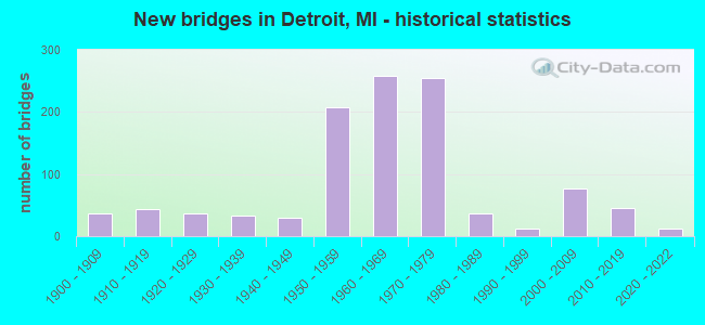
- New bridges - historical statistics
- 1Before 1900
- 371900-1909
- 431910-1919
- 371920-1929
- 331930-1939
- 291940-1949
- 2071950-1959
- 2591960-1969
- 2551970-1979
- 361980-1989
- 131990-1999
- 762000-2009
- 462010-2019
- 132020-2022
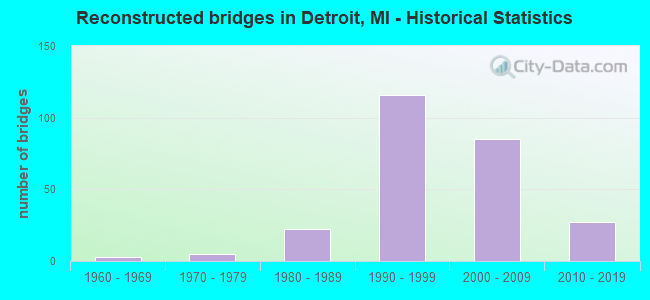
- Reconstructed bridges - Historical Statistics
- 31960-1969
- 51970-1979
- 221980-1989
- 1161990-1999
- 852000-2009
- 272010-2019
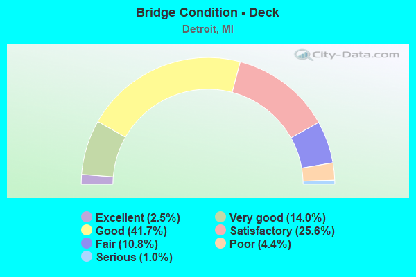
- Bridge Condition - Deck
- 2.5%Excellent
- 14.0%Very good
- 41.7%Good
- 25.6%Satisfactory
- 10.8%Fair
- 4.4%Poor
- 1.0%Serious
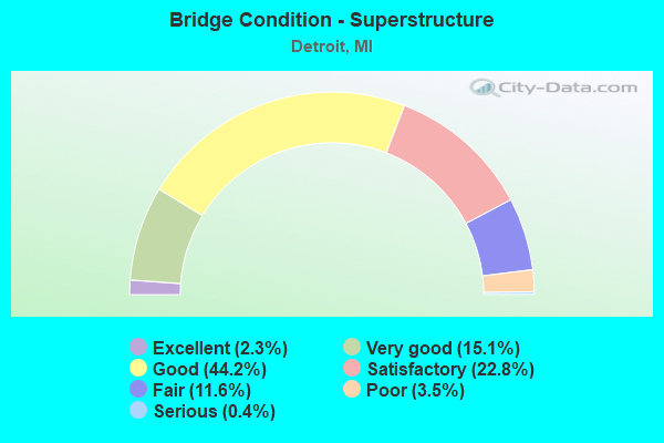
- Bridge Condition - Superstructure
- 2.3%Excellent
- 15.1%Very good
- 44.2%Good
- 22.8%Satisfactory
- 11.6%Fair
- 3.5%Poor
- 0.4%Serious
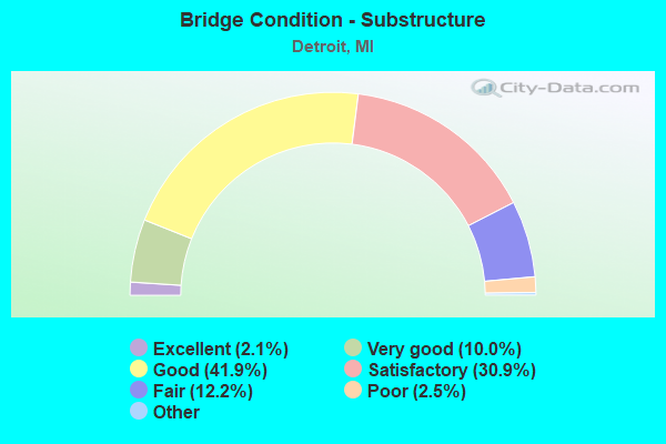
- Bridge Condition - Substructure
- 2.1%Excellent
- 10.0%Very good
- 41.9%Good
- 30.9%Satisfactory
- 12.2%Fair
- 2.5%Poor
- 0.4%Serious
- 0.2%Failed
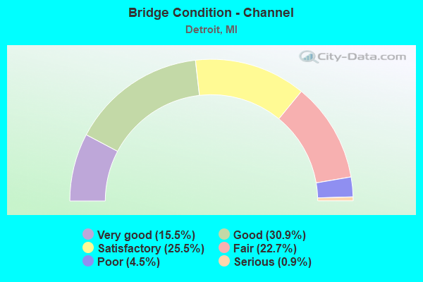
- Bridge Condition - Channel
- 15.5%Very good
- 30.9%Good
- 25.5%Satisfactory
- 22.7%Fair
- 4.5%Poor
- 0.9%Serious
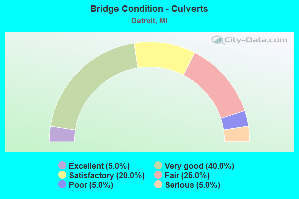
- Bridge Condition - Culverts
- 5.0%Excellent
- 40.0%Very good
- 20.0%Satisfactory
- 25.0%Fair
- 5.0%Poor
- 5.0%Serious
Find on map >> Show street view
Structure Number: 7023, Location: .3 MI N OF OSCEOLA CO LIN (Lat: 44.167933, Lng: -85.153014), Route carried "on" structure: State highway 66, Year Built: 1929, Year Reconstructed: 1989, Status: Open, Structure Length: 0.85m (2.79ft), Average Daily Traffic: 1,485 (year 2007), Truck Traffic: 8%, Average Future Daily Traffic: 3,623 (year 2018), Design Load: H 15, Features Intersected: MIDDLE BR CLAM RIVER
Minimum Vertical Clearance: 30.48m (100.00ft), Kilometerpoint: 0.454, Lanes on structure: 2, Base Highway Network: Yes (Inventory Route: 128, Subroute: 9), Owner: State Highway Agency, Approaching Roadway Width: 14.3m (46.9ft), Material/Design: Concrete, Design/Construction: Tee Beam, Number Of Spans In Main Unit: 1, Length of Maximum Span: 7.9m (25.9ft), Curb-To-Curb Width: 12.8m (42.0ft), Out-to-Out Width: 13.8m (45.3ft)
Condition: Deck: Satisfactory, Superstructure: Satisfactory, Substructure: Satisfactory, Channel: Very good, Operating Rating: 49.2 metric tons, Method Used To Determine Operating Rating: Load Factor (LF) rating reported by rating factor (RF) method using MS18 loading, Inventory Rating: 28.8 metric tons, Method Used To Determine Inventory Rating: Load Factor (LF) rating reported by rating factor (RF) method using MS18 loading, Structural Evaluation: Equal to present minimum criteria, Deck Geometry: Better than present minimum criteria, Waterway Adequacy: Equal to present desirable criteria, Approach Roadway Alignment: Equal to present minimum criteria, Designated Inspection Frequency: Every 24 months, Inspection Date: June 2020, Deck Structure Type: Concrete Cast-file-Place, Wearing Surface/Protective System: Wearing Surface: Epoxy Overlay
Find on map >> Show street view
Structure Number: 7024, Location: 2.7 MI E OF MCBAIN (Lat: 44.193517, Lng: -85.158614), Route carried "on" structure: State highway 66, Year Built: 1933, Year Reconstructed: 1989, Status: Open, Structure Length: 0.82m (2.69ft), Average Daily Traffic: 2,546 (year 2007), Truck Traffic: 5%, Average Future Daily Traffic: 5,455 (year 2018), Design Load: H 15, Features Intersected: N BR CLAM RIVER
Minimum Vertical Clearance: 30.48m (100.00ft), Kilometerpoint: 18.336, Lanes on structure: 2, Base Highway Network: Yes (Inventory Route: 128, Subroute: 2), Owner: State Highway Agency, Approaching Roadway Width: 10.4m (34.1ft), Material/Design: Prestressed concrete, Design/Construction: Box Beam or Girders - Multiple, Number Of Spans In Main Unit: 1, Length of Maximum Span: 8.2m (26.9ft), Curb-To-Curb Width: 12.8m (42.0ft), Out-to-Out Width: 13.7m (44.9ft)
Condition: Deck: Satisfactory, Superstructure: Fair, Substructure: Fair, Channel: Fair, Operating Rating: 97.2 metric tons, Method Used To Determine Operating Rating: Load Factor (LF) rating reported by rating factor (RF) method using MS18 loading, Inventory Rating: 63.8 metric tons, Method Used To Determine Inventory Rating: Load Factor (LF) rating reported by rating factor (RF) method using MS18 loading, Structural Evaluation: Somewhat better than minimum adequacy, Deck Geometry: Equal to present minimum criteria, Waterway Adequacy: Better than present minimum criteria, Approach Roadway Alignment: Equal to present desirable criteria, Designated Inspection Frequency: Every 24 months, Inspection Date: August 2020, Deck Structure Type: Concrete Cast-file-Place, Wearing Surface/Protective System: Wearing Surface: Epoxy Overlay, Deck Protection: Epoxy Coated Reinforcing
Find on map >> Show street view
Structure Number: 7029, Location: 3.4 MI W OF ROSCOMMON COL (Lat: 44.335875, Lng: -84.921583), Route carried "on" structure: State highway 55, Year Built: 1931, Year Reconstructed: 1989, Status: Open, Structure Length: 1.83m (6.00ft), Average Daily Traffic: 4,338 (year 2007), Truck Traffic: 15%, Average Future Daily Traffic: 5,507 (year 2018), Design Load: H 15, Features Intersected: W BR MUSKEGON RIVER
Minimum Vertical Clearance: 30.48m (100.00ft), Kilometerpoint: 23.385, Lanes on structure: 2, Base Highway Network: Yes (Inventory Route: 357, Subroute: 41), Owner: State Highway Agency, Approaching Roadway Width: 11.0m (36.1ft), Skew: 2 degrees, Material/Design: Steel, Design/Construction: Stringer/Multi-beam, Number Of Spans In Main Unit: 1, Length of Maximum Span: 18.2m (59.7ft), Curb-To-Curb Width: 11.0m (36.1ft), Out-to-Out Width: 12.0m (39.4ft)
Condition: Deck: Satisfactory, Superstructure: Satisfactory, Substructure: Satisfactory, Channel: Fair, Operating Rating: 81.0 metric tons, Method Used To Determine Operating Rating: Load Factor (LF) rating reported by rating factor (RF) method using MS18 loading, Inventory Rating: 48.6 metric tons, Method Used To Determine Inventory Rating: Load Factor (LF) rating reported by rating factor (RF) method using MS18 loading, Structural Evaluation: Equal to present minimum criteria, Deck Geometry: Somewhat better than minimum adequacy, Waterway Adequacy: Equal to present desirable criteria, Approach Roadway Alignment: Equal to present minimum criteria, Designated Inspection Frequency: Every 24 months, Inspection Date: July 2020, Deck Structure Type: Concrete Cast-file-Place, Wearing Surface/Protective System: Wearing Surface: Epoxy Overlay, Deck Protection: Epoxy Coated Reinforcing
Find on map >> Show street view
Structure Number: 7033, Location: 8 MI E OF CADILLAC (Lat: 44.264064, Lng: -85.257586), Route carried "on" structure: State highway 55, Year Built: 1973, Status: Open, Structure Length: 3.38m (11.09ft), Average Daily Traffic: 5,113 (year 2007), Truck Traffic: 10%, Average Future Daily Traffic: 7,867 (year 2018), Design Load: HS 20, Features Intersected: CLAM RIVER
Minimum Vertical Clearance: 30.48m (100.00ft), Kilometerpoint: 6.438, Lanes on structure: 2, Base Highway Network: Yes (Inventory Route: 128, Subroute: 5), Owner: State Highway Agency, Approaching Roadway Width: 14.3m (46.9ft), Skew: 4 degrees, Material/Design: Steel, Design/Construction: Stringer/Multi-beam, Number Of Spans In Main Unit: 1, Length of Maximum Span: 33.8m (110.9ft), Curb-To-Curb Width: 14.6m (47.9ft), Out-to-Out Width: 15.1m (49.5ft)
Condition: Deck: Satisfactory, Superstructure: Satisfactory, Substructure: Satisfactory, Channel: Satisfactory, Operating Rating: 97.2 metric tons, Method Used To Determine Operating Rating: Load Factor (LF) rating reported by rating factor (RF) method using MS18 loading, Inventory Rating: 68.0 metric tons, Method Used To Determine Inventory Rating: Load Factor (LF) rating reported by rating factor (RF) method using MS18 loading, Structural Evaluation: Equal to present minimum criteria, Deck Geometry: Superior to present desirable criteria, Waterway Adequacy: Equal to present desirable criteria, Approach Roadway Alignment: Better than present minimum criteria, Length Of Structure Improvement: 3.38m (11.09ft), Designated Inspection Frequency: Every 24 months, Inspection Date: June 2021, Bridge Improvement Cost: $78,000, Roadway Improvement Cost: $4,000, Total Project Cost: $46,000, Deck Structure Type: Concrete Cast-file-Place, Wearing Surface/Protective System: Wearing Surface: Epoxy Overlay
Find on map >> Show street view
Structure Number: 7034, Location: SECTION 23/26 T21N R7W (Lat: 44.193314, Lng: -85.123597), Route carried "on" structure: County highway 5710, Year Built: 1974, Status: Open, Structure Length: 0.73m (2.40ft), Average Daily Traffic: 600 (year 2007), Truck Traffic: 10%, Average Future Daily Traffic: 1,100 (year 2027), Design Load: HS 20+Mod, Features Intersected: NORTH BRANCH CLAM RIVER, Facility Carried by Structure: STONEY CORNER ROAD
Minimum Vertical Clearance: 30.48m (100.00ft), Kilometerpoint: 15.537, Lanes on structure: 2, Owner: County Highway Agency, Approaching Roadway Width: 7.9m (25.9ft), Material/Design: Steel, Design/Construction: Culvert, Number Of Spans In Main Unit: 1, Length of Maximum Span: 6.4m (21.0ft)
Condition: Channel: Satisfactory, Culverts: Satisfactory, Operating Rating: 77.8 metric tons, Method Used To Determine Operating Rating: Load Factor (LF) rating reported by rating factor (RF) method using MS18 loading, Inventory Rating: 46.3 metric tons, Method Used To Determine Inventory Rating: Load Factor (LF) rating reported by rating factor (RF) method using MS18 loading, Structural Evaluation: Equal to present minimum criteria, Waterway Adequacy: Equal to present desirable criteria, Approach Roadway Alignment: Equal to present desirable criteria, Designated Inspection Frequency: Every 12 months, Inspection Date: May 2021
Find on map >> Show street view
Structure Number: 7052, Location: SECTION 28/29 T22N R5W (Lat: 44.275211, Lng: -84.933239), Route carried "on" structure: County highway , Year Built: 2010, Status: Open, Structure Length: 1.10m (3.61ft), Average Daily Traffic: 50 (year 2009), Truck Traffic: 2%, Average Future Daily Traffic: 90 (year 2029), Design Load: HS 20+Mod, Features Intersected: BUTTERFIELD CREEK, Facility Carried by Structure: MCVETY RD
Minimum Vertical Clearance: 30.48m (100.00ft), Kilometerpoint: 8.473, Lanes on structure: 2, Owner: County Highway Agency, Approaching Roadway Width: 9.1m (29.9ft), Material/Design: Wood or Timber, Design/Construction: Stringer/Multi-beam, Number Of Spans In Main Unit: 1, Length of Maximum Span: 10.7m (35.1ft), Curb-To-Curb Width: 9.3m (30.5ft), Out-to-Out Width: 9.9m (32.5ft)
Condition: Deck: Very good, Superstructure: Very good, Substructure: Very good, Channel: Very good, Operating Rating: 75.8 metric tons, Method Used To Determine Operating Rating: Allowable Stress (AS) rating reported by rating factor (RF) method using MS18 loading, Inventory Rating: 53.5 metric tons, Method Used To Determine Inventory Rating: Allowable Stress (AS) rating reported by rating factor (RF) method using MS18 loading, Structural Evaluation: Equal to present desirable criteria, Deck Geometry: Better than present minimum criteria, Waterway Adequacy: Equal to present desirable criteria, Approach Roadway Alignment: Equal to present desirable criteria, Designated Inspection Frequency: Every 24 months, Inspection Date: May 2021, Deck Structure Type: Wood or Timber, Wearing Surface/Protective System: Wearing Surface: Bituminous
Find on map >> Show street view
Structure Number: 7858, Location: N LTS OF DETROIT (Lat: 42.446358, Lng: -83.124739), Route carried "on" structure: State highway 1, Year Built: 1956, Year Reconstructed: 2006, Status: Open, Structure Length: 7.78m (25.52ft), Average Daily Traffic: 19,126 (year 2007), Truck Traffic: 3%, Average Future Daily Traffic: 53,400 (year 2023), Design Load: HS 25 or greater, Features Intersected: M-102 (8 MI RD) & RAMPS
Minimum Vertical Clearance: 30.48m (100.00ft), Kilometerpoint: 0.035, Lanes on structure: 6, Lanes under structure: 12, Base Highway Network: Yes (Inventory Route: 159, Subroute: 7), Owner: State Highway Agency, Approaching Roadway Width: 19.2m (63.0ft), Skew: 32 degrees, Material/Design: Steel, Design/Construction: Stringer/Multi-beam, Number Of Spans In Main Unit: 4, Length of Maximum Span: 21.7m (71.2ft), Curb-To-Curb Width: 25.3m (83.0ft), Out-to-Out Width: 27.3m (89.6ft)
Condition: Deck: Satisfactory, Superstructure: Good, Substructure: Good, Operating Rating: 94.7 metric tons, Method Used To Determine Operating Rating: Load Factor (LF), Inventory Rating: 56.7 metric tons, Method Used To Determine Inventory Rating: Load Factor (LF), Structural Evaluation: Better than present minimum criteria, Deck Geometry: Somewhat better than minimum adequacy, Underclear: Meets minimum limits, Approach Roadway Alignment: Better than present minimum criteria, Designated Inspection Frequency: Every 24 months, Inspection Date: September 2021, Deck Structure Type: Concrete Cast-file-Place, Wearing Surface/Protective System: Wearing Surface: Monolithic Concrete, Deck Protection: Epoxy Coated Reinforcing
Find on map >> Show street view
Structure Number: 7859, Location: @ N LTS OF DETROIT (Lat: 42.446514, Lng: -83.124658), Route carried "on" structure: Ramp State highway 1, Year Built: 1956, Status: Open, Structure Length: 3.66m (12.01ft), Average Daily Traffic: 3,095 (year 1999), Truck Traffic: 18%, Average Future Daily Traffic: 3,466 (year 2014), Design Load: HS 20, Features Intersected: M-102 (8 MILE RD)
Minimum Vertical Clearance: 30.48m (100.00ft), Kilometerpoint: 0.035, Lanes on structure: 3, Lanes under structure: 6, Owner: State Highway Agency, Approaching Roadway Width: 19.2m (63.0ft), Skew: 12 degrees, Material/Design: Steel, Design/Construction: Stringer/Multi-beam, Number Of Spans In Main Unit: 2, Length of Maximum Span: 18.6m (61.0ft), Curb or Sidewalk Widths: Left: 2.9m (9.5ft), Right: 4.6m (15.1ft), Curb-To-Curb Width: 12.2m (40.0ft), Out-to-Out Width: 20.1m (65.9ft)
Condition: Deck: Good, Superstructure: Good, Substructure: Good, Operating Rating: 84.6 metric tons, Method Used To Determine Operating Rating: Load Factor (LF) rating reported by rating factor (RF) method using MS18 loading, Inventory Rating: 50.2 metric tons, Method Used To Determine Inventory Rating: Load Factor (LF) rating reported by rating factor (RF) method using MS18 loading, Structural Evaluation: Better than present minimum criteria, Deck Geometry: High priority of corrective action, Underclear: Meets minimum limits, Approach Roadway Alignment: Equal to present desirable criteria, Designated Inspection Frequency: Every 24 months, Inspection Date: September 2021, Deck Structure Type: Concrete Cast-file-Place, Wearing Surface/Protective System: Wearing Surface: Latex Concrete, Deck Protection: Epoxy Coated Reinforcing
Find on map >> Show street view
Structure Number: 786, Location: AT N LTS OF DETROIT (Lat: 42.446497, Lng: -83.125275), Route carried "on" structure: Ramp State highway 1, Year Built: 1956, Year Reconstructed: 2003, Status: Open, Structure Length: 3.67m (12.04ft), Average Daily Traffic: 3,095 (year 1999), Truck Traffic: 18%, Average Future Daily Traffic: 3,466 (year 2014), Design Load: HS 25 or greater, Features Intersected: M-102 (8 MILE RD)
Minimum Vertical Clearance: 30.48m (100.00ft), Kilometerpoint: 0.035, Lanes on structure: 3, Lanes under structure: 6, Owner: State Highway Agency, Approaching Roadway Width: 19.2m (63.0ft), Skew: 12 degrees, Material/Design: Steel, Design/Construction: Stringer/Multi-beam, Number Of Spans In Main Unit: 2, Length of Maximum Span: 18.3m (60.0ft), Curb or Sidewalk Widths: Left: 2.3m (7.5ft), Right: 4.7m (15.4ft), Curb-To-Curb Width: 13.2m (43.3ft), Out-to-Out Width: 20.1m (65.9ft)
Condition: Deck: Satisfactory, Superstructure: Satisfactory, Substructure: Good, Operating Rating: 84.2 metric tons, Method Used To Determine Operating Rating: Load Factor (LF) rating reported by rating factor (RF) method using MS18 loading, Inventory Rating: 50.5 metric tons, Method Used To Determine Inventory Rating: Load Factor (LF) rating reported by rating factor (RF) method using MS18 loading, Structural Evaluation: Equal to present minimum criteria, Deck Geometry: Somewhat better than minimum adequacy, Underclear: High priority of corrective action, Approach Roadway Alignment: Equal to present desirable criteria, Designated Inspection Frequency: Every 24 months, Inspection Date: September 2021, Deck Structure Type: Concrete Cast-file-Place, Wearing Surface/Protective System: Wearing Surface: Monolithic Concrete, Deck Protection: Epoxy Coated Reinforcing
Find on map >> Show street view
Structure Number: 10242, Location: SEC. 14-15 WALES TWP. (Lat: 42.955764, Lng: -82.663767), Route carried "on" structure: ServiceCounty highway , Year Built: 1920, Status: Posted for load, Structure Length: 1.23m (4.04ft), Average Daily Traffic: 475 (year 1994), Truck Traffic: 4%, Average Future Daily Traffic: 855 (year 2014), Design Load: HS 20+Mod, Features Intersected: UNNAMED CREEK, Facility Carried by Structure: GOODELLS ROAD
Minimum Vertical Clearance: 30.48m (100.00ft), Kilometerpoint: 1.213, Lanes on structure: 2, Owner: County Highway Agency, Approaching Roadway Width: 6.1m (20.0ft), Material/Design: Concrete, Design/Construction: Girder and Floorbeam System, Number Of Spans In Main Unit: 1, Length of Maximum Span: 11.3m (37.1ft), Curb-To-Curb Width: 5.5m (18.0ft), Out-to-Out Width: 6.9m (22.6ft)
Condition: Deck: Poor, Superstructure: Poor, Substructure: Fair, Channel: Fair, Operating Rating: 28.5 metric tons, Method Used To Determine Operating Rating: Load Factor (LF) rating reported by rating factor (RF) method using MS18 loading, Inventory Rating: 16.8 metric tons, Method Used To Determine Inventory Rating: Load Factor (LF) rating reported by rating factor (RF) method using MS18 loading, Structural Evaluation: Meets minimum limits, Deck Geometry: High priority of replacement, Waterway Adequacy: Somewhat better than minimum adequacy, Approach Roadway Alignment: Equal to present desirable criteria, Bridge Posting: Required (Relationship of Operating Rating to Maximum Legal Load: 30.0 - 39.9% below), Length Of Structure Improvement: 1.83m (6.00ft), Designated Inspection Frequency: Every 12 months, Inspection Date: January 2022, Bridge Improvement Cost: $484,000, Roadway Improvement Cost: $43,000, Total Project Cost: $527,000, Deck Structure Type: Concrete Cast-file-Place, Wearing Surface/Protective System: Wearing Surface: Monolithic Concrete
Find on map >> Show street view
Structure Number: 10354, Location: 2 MI N OF BURR OAK (Lat: 41.884103, Lng: -85.331097), Route carried "on" structure: County highway , Year Built: 2008, Status: Open, Structure Length: 0.85m (2.79ft), Average Daily Traffic: 433 (year 2003), Truck Traffic: 5%, Average Future Daily Traffic: 596 (year 2023), Features Intersected: BIG SWAN CREEK, Facility Carried by Structure: MIDDLE COLON ROAD
Minimum Vertical Clearance: 30.48m (100.00ft), Kilometerpoint: 4.904, Lanes on structure: 2, Owner: County Highway Agency, Approaching Roadway Width: 7.3m (24.0ft), Material/Design: Wood or Timber, Design/Construction: Slab, Number Of Spans In Main Unit: 1, Length of Maximum Span: 8.2m (26.9ft), Curb or Sidewalk Widths: Left: 0.2m (0.7ft), Right: 0.2m (0.7ft), Curb-To-Curb Width: 8.5m (27.9ft), Out-to-Out Width: 9.1m (29.9ft)
Condition: Deck: Very good, Superstructure: Very good, Substructure: Very good, Channel: Satisfactory, Operating Rating: 87.8 metric tons, Method Used To Determine Operating Rating: Allowable Stress (AS) rating reported by rating factor (RF) method using MS18 loading, Inventory Rating: 62.5 metric tons, Method Used To Determine Inventory Rating: Allowable Stress (AS) rating reported by rating factor (RF) method using MS18 loading, Structural Evaluation: Equal to present desirable criteria, Deck Geometry: Somewhat better than minimum adequacy, Waterway Adequacy: Equal to present minimum criteria, Approach Roadway Alignment: Equal to present desirable criteria, Designated Inspection Frequency: Every 24 months, Inspection Date: November 2021, Deck Structure Type: Wood or Timber, Wearing Surface/Protective System: Wearing Surface: Bituminous
Find on map >> Show street view
Structure Number: 10356, Location: 1 MI N OF THREE RIVERS (Lat: 41.970139, Lng: -85.647489), Route carried "on" structure: County highway , Year Built: 1993, Status: Open, Structure Length: 3.56m (11.68ft), Average Daily Traffic: 219 (year 2003), Truck Traffic: 5%, Average Future Daily Traffic: 341 (year 2023), Design Load: HS 20, Features Intersected: ROCKY RIVER, Facility Carried by Structure: COWLING ROAD
Minimum Vertical Clearance: 30.48m (100.00ft), Kilometerpoint: 1.772, Lanes on structure: 2, Owner: County Highway Agency, Approaching Roadway Width: 11.0m (36.1ft), Skew: 3 degrees, Material/Design: Prestressed concrete, Design/Construction: Stringer/Multi-beam, Number Of Spans In Main Unit: 3, Length of Maximum Span: 11.8m (38.7ft), Curb-To-Curb Width: 11.0m (36.1ft), Out-to-Out Width: 11.7m (38.4ft)
Condition: Deck: Very good, Superstructure: Very good, Substructure: Good, Channel: Very good, Operating Rating: 70.0 metric tons, Method Used To Determine Operating Rating: Load Factor (LF), Inventory Rating: 41.9 metric tons, Method Used To Determine Inventory Rating: Load Factor (LF), Structural Evaluation: Better than present minimum criteria, Waterway Adequacy: Equal to present desirable criteria, Approach Roadway Alignment: Equal to present minimum criteria, Designated Inspection Frequency: Every 24 months, Inspection Date: November 2021, Deck Structure Type: Concrete Cast-file-Place, Wearing Surface/Protective System: Wearing Surface: Bituminous, Deck Protection: Epoxy Coated Reinforcing
Find on map >> Show street view
Structure Number: 10364, Location: 2 MI E OF CENTREVILLE (Lat: 41.920581, Lng: -85.487647), Route carried "on" structure: County highway , Year Built: 1971, Status: Posted for load, Structure Length: 2.29m (7.51ft), Average Daily Traffic: 333 (year 2003), Truck Traffic: 5%, Average Future Daily Traffic: 470 (year 2023), Design Load: H 20, Features Intersected: PRAIRIE RIVER, Facility Carried by Structure: RAMBADT ROAD
Minimum Vertical Clearance: 30.48m (100.00ft), Kilometerpoint: 1.928, Lanes on structure: 2, Owner: County Highway Agency, Approaching Roadway Width: 9.1m (29.9ft), Material/Design: Wood or Timber, Design/Construction: Slab, Number Of Spans In Main Unit: 3, Length of Maximum Span: 7.9m (25.9ft), Curb-To-Curb Width: 9.1m (29.9ft), Out-to-Out Width: 9.7m (31.8ft)
Condition: Deck: Satisfactory, Superstructure: Satisfactory, Substructure: Fair, Channel: Satisfactory, Operating Rating: 42.1 metric tons, Method Used To Determine Operating Rating: Allowable Stress (AS) rating reported by rating factor (RF) method using MS18 loading, Inventory Rating: 28.5 metric tons, Method Used To Determine Inventory Rating: Allowable Stress (AS) rating reported by rating factor (RF) method using MS18 loading, Structural Evaluation: Somewhat better than minimum adequacy, Deck Geometry: Equal to present minimum criteria, Waterway Adequacy: Meets minimum limits, Approach Roadway Alignment: Equal to present minimum criteria, Bridge Posting: Required (Relationship of Operating Rating to Maximum Legal Load: 0.1 - 9.9% below), Designated Inspection Frequency: Every 24 months, Inspection Date: November 2021, Deck Structure Type: Wood or Timber, Wearing Surface/Protective System: Wearing Surface: Bituminous
Find on map >> Show street view
Structure Number: 10365, Location: 2 MI NE OF CENTREVILLE (Lat: 41.942858, Lng: -85.487992), Route carried "on" structure: County highway , Year Built: 1999, Status: Open, Structure Length: 1.01m (3.31ft), Average Daily Traffic: 99 (year 2003), Truck Traffic: 5%, Average Future Daily Traffic: 135 (year 2023), Design Load: HS 20, Features Intersected: SPRING CREEK, Facility Carried by Structure: RAMBADT ROAD
Minimum Vertical Clearance: 30.48m (100.00ft), Kilometerpoint: 4.365, Lanes on structure: 2, Owner: County Highway Agency, Approaching Roadway Width: 4.9m (16.1ft), Material/Design: Wood or Timber, Design/Construction: Slab, Number Of Spans In Main Unit: 2, Length of Maximum Span: 5.0m (16.4ft), Curb-To-Curb Width: 9.1m (29.9ft), Out-to-Out Width: 9.6m (31.5ft)
Condition: Deck: Good, Superstructure: Good, Substructure: Satisfactory, Channel: Satisfactory, Operating Rating: 49.8 metric tons, Method Used To Determine Operating Rating: Allowable Stress (AS), Inventory Rating: 36.6 metric tons, Method Used To Determine Inventory Rating: Allowable Stress (AS), Structural Evaluation: Equal to present minimum criteria, Waterway Adequacy: Equal to present minimum criteria, Approach Roadway Alignment: Equal to present desirable criteria, Designated Inspection Frequency: Every 24 months, Inspection Date: November 2021, Deck Structure Type: Wood or Timber, Wearing Surface/Protective System: Wearing Surface: Bituminous
Find on map >> Show street view
Structure Number: 10703, Location: 6.0 MI E OF BERRIEN COL (Lat: 42.195322, Lng: -86.108422), Route carried "on" structure: County highway 8039, Year Built: 1960, Status: Open, Structure Length: 8.25m (27.07ft), Average Daily Traffic: 2,830 (year 1997), Truck Traffic: 2%, Average Future Daily Traffic: 3,255 (year 2017), Design Load: H 15, Features Intersected: I-94, Facility Carried by Structure: 58 TH ST (CR681)
Minimum Vertical Clearance: 30.48m (100.00ft), Kilometerpoint: 11.903, Lanes on structure: 2, Lanes under structure: 4, Owner: State Highway Agency, Approaching Roadway Width: 7.9m (25.9ft), Skew: 2 degrees, Material/Design: Concrete continuous, Design/Construction: Tee Beam, Number Of Spans In Main Unit: 4, Length of Maximum Span: 23.5m (77.1ft), Curb-To-Curb Width: 9.0m (29.5ft), Out-to-Out Width: 10.2m (33.5ft)
Condition: Deck: Satisfactory, Superstructure: Satisfactory, Substructure: Satisfactory, Operating Rating: 43.1 metric tons, Method Used To Determine Operating Rating: Load Factor (LF) rating reported by rating factor (RF) method using MS18 loading, Inventory Rating: 25.9 metric tons, Method Used To Determine Inventory Rating: Load Factor (LF) rating reported by rating factor (RF) method using MS18 loading, Structural Evaluation: Equal to present minimum criteria, Deck Geometry: Meets minimum limits, Underclear: Equal to present minimum criteria, Approach Roadway Alignment: Better than present minimum criteria, Designated Inspection Frequency: Every 24 months, Inspection Date: October 2021, Deck Structure Type: Concrete Cast-file-Place, Wearing Surface/Protective System: Wearing Surface: Monolithic Concrete
Find on map >> Show street view
Structure Number: 1071, Location: 0.6 MI W OF M-40 (Lat: 42.205897, Lng: -85.901583), Route carried "on" structure: Interstate 94, Year Built: 1960, Year Reconstructed: 2006, Status: Open, Structure Length: 4.44m (14.57ft), Average Daily Traffic: 15,986 (year 2007), Truck Traffic: 24%, Average Future Daily Traffic: 25,540 (year 2018), Design Load: HS 20+Mod, Features Intersected: S BR PAW PAW RIVER
Minimum Vertical Clearance: 30.48m (100.00ft), Kilometerpoint: 27.139, Lanes on structure: 2, Base Highway Network: Yes (Inventory Route: 58, Subroute: 3), Owner: State Highway Agency, Approaching Roadway Width: 11.9m (39.0ft), Skew: 4 degrees, Material/Design: Prestressed concrete, Design/Construction: Stringer/Multi-beam, Number Of Spans In Main Unit: 3, Length of Maximum Span: 15.0m (49.2ft), Curb-To-Curb Width: 13.5m (44.3ft), Out-to-Out Width: 14.3m (46.9ft)
Condition: Deck: Fair, Superstructure: Satisfactory, Substructure: Fair, Channel: Fair, Operating Rating: 97.2 metric tons, Method Used To Determine Operating Rating: Load Factor (LF) rating reported by rating factor (RF) method using MS18 loading, Inventory Rating: 59.6 metric tons, Method Used To Determine Inventory Rating: Load Factor (LF) rating reported by rating factor (RF) method using MS18 loading, Structural Evaluation: Somewhat better than minimum adequacy, Deck Geometry: Superior to present desirable criteria, Waterway Adequacy: Equal to present desirable criteria, Approach Roadway Alignment: Equal to present desirable criteria, Designated Inspection Frequency: Every 24 months, Inspection Date: October 2021, Deck Structure Type: Concrete Cast-file-Place, Wearing Surface/Protective System: Wearing Surface: Latex Concrete
Find on map >> Show street view
Structure Number: 10718, Location: AT M-40 (Lat: 42.206147, Lng: -85.889594), Route carried "on" structure: State highway 40, Year Built: 1960, Year Reconstructed: 1981, Status: Open, Structure Length: 9.63m (31.59ft), Average Daily Traffic: 8,601 (year 2007), Truck Traffic: 28%, Average Future Daily Traffic: 45,000 (year 2026), Design Load: HS 20, Features Intersected: I-94
Minimum Vertical Clearance: 30.48m (100.00ft), Kilometerpoint: 17.753, Lanes on structure: 4, Lanes under structure: 5, Base Highway Network: Yes (Inventory Route: 57, Subroute: 1), Owner: State Highway Agency, Approaching Roadway Width: 15.8m (51.8ft), Skew: 4 degrees, Material/Design: Concrete continuous, Design/Construction: Tee Beam, Number Of Spans In Main Unit: 4, Length of Maximum Span: 32.8m (107.6ft), Curb-To-Curb Width: 15.7m (51.5ft), Out-to-Out Width: 16.9m (55.4ft)
Condition: Deck: Poor, Superstructure: Fair, Substructure: Fair, Operating Rating: 56.0 metric tons, Method Used To Determine Operating Rating: Load Factor (LF), Inventory Rating: 33.5 metric tons, Method Used To Determine Inventory Rating: Load Factor (LF), Structural Evaluation: Somewhat better than minimum adequacy, Deck Geometry: Meets minimum limits, Underclear: Meets minimum limits, Approach Roadway Alignment: Equal to present desirable criteria, Designated Inspection Frequency: Every 24 months, Other Special Inspection Frequency: Every 24 months, Inspection Date: October 2021, Other Special Inspection Date: October 2020, Deck Structure Type: Concrete Cast-file-Place, Wearing Surface/Protective System: Wearing Surface: Latex Concrete
Find on map >> Show street view
Structure Number: 11142, Location: W LTS OF DETROIT (Lat: 42.328733, Lng: -83.156675), Route carried "on" structure: State highway 153, Year Built: 1949, Year Reconstructed: 1995, Status: Open, Structure Length: 5.59m (18.34ft), Average Daily Traffic: 14,956 (year 2007), Truck Traffic: 9%, Average Future Daily Traffic: 17,375 (year 2018), Design Load: HS 20, Features Intersected: I-94, Facility Carried by Structure: WYOMING AVE
Minimum Vertical Clearance: 30.48m (100.00ft), Kilometerpoint: 0.132, Lanes on structure: 6, Lanes under structure: 6, Base Highway Network: Yes (Inventory Route: 470, Subroute: 72), Owner: State Highway Agency, Approaching Roadway Width: 18.2m (59.7ft), Skew: 1 degrees, Material/Design: Steel, Design/Construction: Stringer/Multi-beam, Number Of Spans In Main Unit: 4, Length of Maximum Span: 17.3m (56.8ft), Curb or Sidewalk Widths: Left: 3.9m (12.8ft), Right: 3.9m (12.8ft), Curb-To-Curb Width: 18.3m (60.0ft), Out-to-Out Width: 26.8m (87.9ft)
Condition: Deck: Satisfactory, Superstructure: Satisfactory, Substructure: Satisfactory, Operating Rating: 97.2 metric tons, Method Used To Determine Operating Rating: Load Factor (LF) rating reported by rating factor (RF) method using MS18 loading, Inventory Rating: 63.8 metric tons, Method Used To Determine Inventory Rating: Load Factor (LF) rating reported by rating factor (RF) method using MS18 loading, Structural Evaluation: Equal to present minimum criteria, Deck Geometry: High priority of replacement, Underclear: High priority of corrective action, Approach Roadway Alignment: Better than present minimum criteria, Designated Inspection Frequency: Every 24 months, Inspection Date: September 2021, Deck Structure Type: Concrete Cast-file-Place, Wearing Surface/Protective System: Wearing Surface: Monolithic Concrete, Deck Protection: Epoxy Coated Reinforcing
Find on map >> Show street view
Structure Number: 11169, Location: IN DETROIT (Lat: 42.329278, Lng: -83.154278), Route carried "on" structure: City street 2000, Year Built: 1950, Year Reconstructed: 1994, Status: Open, Structure Length: 6.44m (21.13ft), Average Daily Traffic: 9,840 (year 2007), Average Future Daily Traffic: 10,000 (year 2018), Design Load: HS 20, Features Intersected: I-94, Facility Carried by Structure: WEIR RD
Minimum Vertical Clearance: 30.48m (100.00ft), Kilometerpoint: 0.111, Lanes on structure: 2, Lanes under structure: 6, Owner: State Highway Agency, Approaching Roadway Width: 9.1m (29.9ft), Skew: 3 degrees, Material/Design: Steel, Design/Construction: Stringer/Multi-beam, Number Of Spans In Main Unit: 4, Length of Maximum Span: 21.6m (70.9ft), Curb or Sidewalk Widths: Left: 0.0m, Right: 2.3m (7.5ft), Curb-To-Curb Width: 9.4m (30.8ft), Out-to-Out Width: 12.6m (41.3ft)
Condition: Deck: Good, Superstructure: Good, Substructure: Good, Operating Rating: 87.2 metric tons, Method Used To Determine Operating Rating: Load Factor (LF) rating reported by rating factor (RF) method using MS18 loading, Inventory Rating: 52.2 metric tons, Method Used To Determine Inventory Rating: Load Factor (LF) rating reported by rating factor (RF) method using MS18 loading, Structural Evaluation: Better than present minimum criteria, Deck Geometry: Meets minimum limits, Underclear: High priority of corrective action, Approach Roadway Alignment: Better than present minimum criteria, Designated Inspection Frequency: Every 24 months, Inspection Date: September 2021, Deck Structure Type: Concrete Cast-file-Place, Wearing Surface/Protective System: Wearing Surface: Epoxy Overlay, Deck Protection: Epoxy Coated Reinforcing
Find on map >> Show street view
Structure Number: 1117, Location: IN DETROIT (Lat: 42.330050, Lng: -83.150942), Route carried "on" structure: City street , Year Built: 1949, Year Reconstructed: 1996, Status: Open, Structure Length: 3.78m (12.40ft), Average Daily Traffic: 4,000 (year 1994), Truck Traffic: 12%, Average Future Daily Traffic: 8,000 (year 2014), Design Load: HS 20, Features Intersected: I-94, Facility Carried by Structure: ADDISON RD
Minimum Vertical Clearance: 30.48m (100.00ft), Kilometerpoint: 0.069, Lanes on structure: 4, Lanes under structure: 6, Owner: State Highway Agency, Approaching Roadway Width: 13.4m (44.0ft), Skew: 1 degrees, Material/Design: Steel, Design/Construction: Stringer/Multi-beam, Number Of Spans In Main Unit: 2, Length of Maximum Span: 18.9m (62.0ft), Curb or Sidewalk Widths: Left: 1.7m (5.6ft), Right: 1.7m (5.6ft), Curb-To-Curb Width: 13.4m (44.0ft), Out-to-Out Width: 17.5m (57.4ft)
Condition: Deck: Good, Superstructure: Satisfactory, Substructure: Satisfactory, Operating Rating: 97.2 metric tons, Method Used To Determine Operating Rating: Load Factor (LF) rating reported by rating factor (RF) method using MS18 loading, Inventory Rating: 72.9 metric tons, Method Used To Determine Inventory Rating: Load Factor (LF) rating reported by rating factor (RF) method using MS18 loading, Structural Evaluation: Equal to present minimum criteria, Deck Geometry: High priority of replacement, Underclear: High priority of corrective action, Approach Roadway Alignment: Better than present minimum criteria, Designated Inspection Frequency: Every 24 months, Inspection Date: September 2021, Deck Structure Type: Concrete Cast-file-Place, Wearing Surface/Protective System: Wearing Surface: Monolithic Concrete, Deck Protection: Epoxy Coated Reinforcing
Find on map >> Show street view
Structure Number: 11171, Location: IN DETROIT (Lat: 42.331258, Lng: -83.145031), Route carried "on" structure: City street 2000, Year Built: 1949, Year Reconstructed: 2006, Status: Open, Structure Length: 5.43m (17.81ft), Average Daily Traffic: 13,370 (year 1978), Average Future Daily Traffic: 12,250 (year 2026), Design Load: HS 20, Features Intersected: I-94, Facility Carried by Structure: LONYO AVE
Minimum Vertical Clearance: 30.48m (100.00ft), Kilometerpoint: 1.854, Lanes on structure: 4, Lanes under structure: 6, Owner: State Highway Agency, Approaching Roadway Width: 13.4m (44.0ft), Skew: 1 degrees, Material/Design: Steel, Design/Construction: Stringer/Multi-beam, Number Of Spans In Main Unit: 4, Length of Maximum Span: 17.4m (57.1ft), Curb or Sidewalk Widths: Left: 2.4m (7.9ft), Right: 2.4m (7.9ft), Curb-To-Curb Width: 14.0m (45.9ft), Out-to-Out Width: 19.6m (64.3ft)
Condition: Deck: Very good, Superstructure: Good, Substructure: Good, Operating Rating: 96.2 metric tons, Method Used To Determine Operating Rating: Load Factor (LF) rating reported by rating factor (RF) method using MS18 loading, Inventory Rating: 57.7 metric tons, Method Used To Determine Inventory Rating: Load Factor (LF) rating reported by rating factor (RF) method using MS18 loading, Structural Evaluation: Better than present minimum criteria, Deck Geometry: High priority of replacement, Underclear: High priority of corrective action, Approach Roadway Alignment: Equal to present desirable criteria, Designated Inspection Frequency: Every 24 months, Inspection Date: September 2021, Bridge Improvement Cost: $217,000, Deck Structure Type: Concrete Cast-file-Place, Wearing Surface/Protective System: Wearing Surface: Monolithic Concrete, Deck Protection: Epoxy Coated Reinforcing
Find on map >> Show street view
Structure Number: 11172, Location: IN DETROIT (Lat: 42.332314, Lng: -83.138408), Route carried "on" structure: City street 2000, Year Built: 1950, Status: Open, Structure Length: 5.60m (18.37ft), Average Daily Traffic: 5,756 (year 1992), Average Future Daily Traffic: 6,619 (year 2012), Design Load: HS 20, Features Intersected: I-94, Facility Carried by Structure: CENTRAL AVE
Minimum Vertical Clearance: 30.48m (100.00ft), Kilometerpoint: 3.729, Lanes on structure: 4, Lanes under structure: 6, Owner: State Highway Agency, Approaching Roadway Width: 13.4m (44.0ft), Skew: 1 degrees, Material/Design: Steel, Design/Construction: Stringer/Multi-beam, Number Of Spans In Main Unit: 4, Length of Maximum Span: 16.8m (55.1ft), Curb or Sidewalk Widths: Left: 1.7m (5.6ft), Right: 1.7m (5.6ft), Curb-To-Curb Width: 13.4m (44.0ft), Out-to-Out Width: 17.6m (57.7ft)
Condition: Deck: Good, Superstructure: Satisfactory, Substructure: Satisfactory, Operating Rating: 97.2 metric tons, Method Used To Determine Operating Rating: Load Factor (LF) rating reported by rating factor (RF) method using MS18 loading, Inventory Rating: 77.1 metric tons, Method Used To Determine Inventory Rating: Load Factor (LF) rating reported by rating factor (RF) method using MS18 loading, Structural Evaluation: Equal to present minimum criteria, Deck Geometry: High priority of replacement, Underclear: High priority of corrective action, Approach Roadway Alignment: Better than present minimum criteria, Designated Inspection Frequency: Every 24 months, Inspection Date: March 2021, Deck Structure Type: Concrete Cast-file-Place, Wearing Surface/Protective System: Wearing Surface: Epoxy Overlay
Find on map >> Show street view
Structure Number: 11173, Location: IN DETROIT (Lat: 42.333739, Lng: -83.133889), Route carried "on" structure: City street , Year Built: 1950, Year Reconstructed: 1996, Status: Open, Structure Length: 5.34m (17.52ft), Average Daily Traffic: 5,000 (year 1994), Truck Traffic: 2%, Average Future Daily Traffic: 5,500 (year 2025), Design Load: HS 20, Features Intersected: I-94, Facility Carried by Structure: CECIL AVE
Minimum Vertical Clearance: 30.48m (100.00ft), Kilometerpoint: 0.335, Lanes on structure: 4, Lanes under structure: 6, Owner: State Highway Agency, Approaching Roadway Width: 13.4m (44.0ft), Material/Design: Steel, Design/Construction: Stringer/Multi-beam, Number Of Spans In Main Unit: 4, Length of Maximum Span: 16.5m (54.1ft), Curb or Sidewalk Widths: Left: 1.7m (5.6ft), Right: 1.7m (5.6ft), Curb-To-Curb Width: 13.4m (44.0ft), Out-to-Out Width: 17.6m (57.7ft)
Condition: Deck: Good, Superstructure: Good, Substructure: Satisfactory, Operating Rating: 75.8 metric tons, Method Used To Determine Operating Rating: Load Factor (LF) rating reported by rating factor (RF) method using MS18 loading, Inventory Rating: 45.4 metric tons, Method Used To Determine Inventory Rating: Load Factor (LF) rating reported by rating factor (RF) method using MS18 loading, Structural Evaluation: Equal to present minimum criteria, Deck Geometry: High priority of replacement, Underclear: High priority of corrective action, Approach Roadway Alignment: Equal to present desirable criteria, Designated Inspection Frequency: Every 24 months, Inspection Date: March 2021, Deck Structure Type: Concrete Cast-file-Place, Wearing Surface/Protective System: Wearing Surface: Epoxy Overlay, Deck Protection: Epoxy Coated Reinforcing
Find on map >> Show street view
Structure Number: 11174, Location: IN DETROIT (Lat: 42.335153, Lng: -83.130306), Route carried "on" structure: City street , Year Built: 1949, Status: Open, Structure Length: 5.32m (17.45ft), Average Daily Traffic: 5,948 (year 2010), Average Future Daily Traffic: 6,543 (year 2025), Design Load: HS 20, Features Intersected: I-94, Facility Carried by Structure: MARTIN STREET
Minimum Vertical Clearance: 30.48m (100.00ft), Kilometerpoint: 1.489, Lanes on structure: 2, Lanes under structure: 6, Owner: State Highway Agency, Approaching Roadway Width: 13.4m (44.0ft), Material/Design: Steel, Design/Construction: Stringer/Multi-beam, Number Of Spans In Main Unit: 4, Length of Maximum Span: 16.5m (54.1ft), Curb or Sidewalk Widths: Left: 3.3m (10.8ft), Right: 3.3m (10.8ft), Curb-To-Curb Width: 13.4m (44.0ft), Out-to-Out Width: 20.7m (67.9ft)
Condition: Deck: Good, Superstructure: Satisfactory, Substructure: Good, Operating Rating: 88.8 metric tons, Method Used To Determine Operating Rating: Load Factor (LF) rating reported by rating factor (RF) method using MS18 loading, Inventory Rating: 53.1 metric tons, Method Used To Determine Inventory Rating: Load Factor (LF) rating reported by rating factor (RF) method using MS18 loading, Structural Evaluation: Equal to present minimum criteria, Deck Geometry: Equal to present minimum criteria, Underclear: High priority of corrective action, Approach Roadway Alignment: Better than present minimum criteria, Designated Inspection Frequency: Every 24 months, Inspection Date: March 2021, Deck Structure Type: Concrete Cast-file-Place, Wearing Surface/Protective System: Wearing Surface: Epoxy Overlay
Find on map >> Show street view
Structure Number: 11175, Location: IN DETROIT (Lat: 42.337325, Lng: -83.124850), Route carried "on" structure: City street 2000, Year Built: 1950, Year Reconstructed: 1997, Status: Open, Structure Length: 6.37m (20.90ft), Average Daily Traffic: 25,050 (year 1978), Average Future Daily Traffic: 25,050 (year 1977), Design Load: HS 20, Features Intersected: I-94, Facility Carried by Structure: LIVERNOIS AVE
Minimum Vertical Clearance: 30.48m (100.00ft), Kilometerpoint: 4.659, Lanes on structure: 6, Lanes under structure: 8, Base Highway Network: Yes (Inventory Route: 158, Subroute: 1), Owner: State Highway Agency, Approaching Roadway Width: 30.1m (98.8ft), Skew: 20 degrees, Material/Design: Prestressed concrete, Design/Construction: Stringer/Multi-beam, Number Of Spans In Main Unit: 4, Length of Maximum Span: 22.0m (72.2ft), Curb or Sidewalk Widths: Left: 4.5m (14.8ft), Right: 4.5m (14.8ft), Curb-To-Curb Width: 27.4m (89.9ft), Out-to-Out Width: 37.1m (121.7ft)
Condition: Deck: Very good, Superstructure: Good, Substructure: Satisfactory, Operating Rating: 41.1 metric tons, Method Used To Determine Operating Rating: Load and Resistance Factor Rating (LRFR) rating reported by rating factor(RF) method using HL-93 loadings, Inventory Rating: 24.3 metric tons, Method Used To Determine Inventory Rating: Load and Resistance Factor Rating (LRFR) rating reported by rating factor(RF) method using HL-93 loadings, Structural Evaluation: Equal to present minimum criteria, Deck Geometry: Better than present minimum criteria, Underclear: High priority of corrective action, Approach Roadway Alignment: Equal to present desirable criteria, Designated Inspection Frequency: Every 24 months, Inspection Date: March 2021, Deck Structure Type: Concrete Cast-file-Place, Wearing Surface/Protective System: Wearing Surface: Monolithic Concrete, Deck Protection: Epoxy Coated Reinforcing
Find on map >> Show street view
Structure Number: 11177, Location: IN DETROIT (Lat: 42.340325, Lng: -83.118356), Route carried "on" structure: City street , Year Built: 1950, Year Reconstructed: 1996, Status: Open, Structure Length: 5.22m (17.13ft), Average Daily Traffic: 3,500 (year 1994), Truck Traffic: 7%, Average Future Daily Traffic: 4,025 (year 2014), Design Load: HS 20, Features Intersected: I-94, Facility Carried by Structure: JUNCTION ST
Minimum Vertical Clearance: 30.48m (100.00ft), Kilometerpoint: 1.152, Lanes on structure: 4, Lanes under structure: 6, Owner: State Highway Agency, Approaching Roadway Width: 13.4m (44.0ft), Skew: 1 degrees, Material/Design: Steel, Design/Construction: Stringer/Multi-beam, Number Of Spans In Main Unit: 4, Length of Maximum Span: 17.3m (56.8ft), Curb or Sidewalk Widths: Left: 1.7m (5.6ft), Right: 1.7m (5.6ft), Curb-To-Curb Width: 13.4m (44.0ft), Out-to-Out Width: 17.6m (57.7ft)
Condition: Deck: Good, Superstructure: Satisfactory, Substructure: Satisfactory, Operating Rating: 97.2 metric tons, Method Used To Determine Operating Rating: Load Factor (LF) rating reported by rating factor (RF) method using MS18 loading, Inventory Rating: 64.5 metric tons, Method Used To Determine Inventory Rating: Load Factor (LF) rating reported by rating factor (RF) method using MS18 loading, Structural Evaluation: Equal to present minimum criteria, Deck Geometry: High priority of replacement, Underclear: High priority of corrective action, Approach Roadway Alignment: Equal to present desirable criteria, Designated Inspection Frequency: Every 24 months, Inspection Date: June 2020, Deck Structure Type: Concrete Cast-file-Place, Wearing Surface/Protective System: Wearing Surface: Epoxy Overlay, Deck Protection: Epoxy Coated Reinforcing
Find on map >> Show street view
Structure Number: 11178, Location: IN DETROIT (Lat: 42.343028, Lng: -83.115119), Route carried "on" structure: City street , Year Built: 1951, Year Reconstructed: 1996, Status: Open, Structure Length: 5.42m (17.78ft), Average Daily Traffic: 6,000 (year 1994), Truck Traffic: 2%, Average Future Daily Traffic: 6,000 (year 2014), Design Load: HS 20, Features Intersected: I-94, Facility Carried by Structure: 30TH ST
Minimum Vertical Clearance: 30.48m (100.00ft), Kilometerpoint: 0.801, Lanes on structure: 4, Lanes under structure: 6, Owner: State Highway Agency, Approaching Roadway Width: 13.4m (44.0ft), Skew: 2 degrees, Material/Design: Steel, Design/Construction: Stringer/Multi-beam, Number Of Spans In Main Unit: 4, Length of Maximum Span: 17.6m (57.7ft), Curb or Sidewalk Widths: Left: 3.3m (10.8ft), Right: 3.3m (10.8ft), Curb-To-Curb Width: 13.4m (44.0ft), Out-to-Out Width: 20.6m (67.6ft)
Condition: Deck: Satisfactory, Superstructure: Good, Substructure: Fair, Operating Rating: 97.2 metric tons, Method Used To Determine Operating Rating: Load Factor (LF) rating reported by rating factor (RF) method using MS18 loading, Inventory Rating: 58.0 metric tons, Method Used To Determine Inventory Rating: Load Factor (LF) rating reported by rating factor (RF) method using MS18 loading, Structural Evaluation: Somewhat better than minimum adequacy, Deck Geometry: High priority of replacement, Underclear: High priority of corrective action, Approach Roadway Alignment: Equal to present desirable criteria, Designated Inspection Frequency: Every 24 months, Inspection Date: June 2020, Deck Structure Type: Concrete Cast-file-Place, Wearing Surface/Protective System: Wearing Surface: Monolithic Concrete, Deck Protection: Epoxy Coated Reinforcing
Find on map >> Show street view
Structure Number: 11179, Location: IN DETROIT (Lat: 42.344703, Lng: -83.112925), Route carried "on" structure: City street 2000, Year Built: 1953, Year Reconstructed: 1997, Status: Open, Structure Length: 8.74m (28.67ft), Average Daily Traffic: 5,766 (year 2010), Truck Traffic: 1%, Average Future Daily Traffic: 6,343 (year 2025), Design Load: HS 20, Features Intersected: I-94, Facility Carried by Structure: WARREN AVE
Minimum Vertical Clearance: 30.48m (100.00ft), Kilometerpoint: 6.872, Lanes on structure: 4, Lanes under structure: 6, Base Highway Network: Yes (Inventory Route: 162, Subroute: 4), Owner: State Highway Agency, Approaching Roadway Width: 25.0m (82.0ft), Skew: 24 degrees, Material/Design: Steel, Design/Construction: Stringer/Multi-beam, Number Of Spans In Main Unit: 5, Length of Maximum Span: 27.9m (91.5ft), Curb or Sidewalk Widths: Left: 3.6m (11.8ft), Right: 3.6m (11.8ft), Curb-To-Curb Width: 23.2m (76.1ft), Out-to-Out Width: 31.0m (101.7ft)
Condition: Deck: Very good, Superstructure: Satisfactory, Substructure: Good, Operating Rating: 97.2 metric tons, Method Used To Determine Operating Rating: Load Factor (LF) rating reported by rating factor (RF) method using MS18 loading, Inventory Rating: 54.1 metric tons, Method Used To Determine Inventory Rating: Load Factor (LF) rating reported by rating factor (RF) method using MS18 loading, Structural Evaluation: Equal to present minimum criteria, Deck Geometry: Superior to present desirable criteria, Underclear: High priority of corrective action, Approach Roadway Alignment: Equal to present desirable criteria, Designated Inspection Frequency: Every 24 months, Inspection Date: March 2021, Deck Structure Type: Concrete Cast-file-Place, Wearing Surface/Protective System: Wearing Surface: Epoxy Overlay, Deck Protection: Epoxy Coated Reinforcing
Find on map >> Show street view
Structure Number: 1118, Location: IN DETROIT (Lat: 42.345514, Lng: -83.111617), Route carried "on" structure: City street , Year Built: 1953, Year Reconstructed: 1997, Status: Open, Structure Length: 8.07m (26.48ft), Average Daily Traffic: 1,907 (year 2010), Average Future Daily Traffic: 2,098 (year 2025), Design Load: HS 20, Features Intersected: I-94, Facility Carried by Structure: SCOTTEN AVE
Minimum Vertical Clearance: 30.48m (100.00ft), Kilometerpoint: 3.883, Lanes on structure: 4, Lanes under structure: 8, Owner: State Highway Agency, Approaching Roadway Width: 13.4m (44.0ft), Skew: 1 degrees, Material/Design: Prestressed concrete, Design/Construction: Stringer/Multi-beam, Number Of Spans In Main Unit: 6, Length of Maximum Span: 21.2m (69.6ft), Curb or Sidewalk Widths: Left: 3.3m (10.8ft), Right: 3.3m (10.8ft), Curb-To-Curb Width: 13.2m (43.3ft), Out-to-Out Width: 20.6m (67.6ft)
Condition: Deck: Good, Superstructure: Very good, Substructure: Satisfactory, Operating Rating: 52.5 metric tons, Method Used To Determine Operating Rating: Load Factor (LF) rating reported by rating factor (RF) method using MS18 loading, Inventory Rating: 31.4 metric tons, Method Used To Determine Inventory Rating: Load Factor (LF) rating reported by rating factor (RF) method using MS18 loading, Structural Evaluation: Equal to present minimum criteria, Deck Geometry: High priority of replacement, Underclear: High priority of corrective action, Approach Roadway Alignment: Equal to present desirable criteria, Designated Inspection Frequency: Every 24 months, Inspection Date: April 2020, Deck Structure Type: Concrete Cast-file-Place, Wearing Surface/Protective System: Wearing Surface: Monolithic Concrete, Deck Protection: Epoxy Coated Reinforcing
Find on map >> Show street view
Structure Number: 11181, Location: IN DETROIT (Lat: 42.346608, Lng: -83.109428), Route carried "on" structure: City street 2000, Year Built: 2013, Status: Open, Structure Length: 6.10m (20.01ft), Average Daily Traffic: 2,070 (year 2013), Truck Traffic: 5%, Average Future Daily Traffic: 2,285 (year 2033), Design Load: Greater than HL93, Features Intersected: I-94, Facility Carried by Structure: SB W GRAND BLVD
Minimum Vertical Clearance: 30.48m (100.00ft), Kilometerpoint: 0.608, Lanes on structure: 4, Lanes under structure: 6, Owner: State Highway Agency, Approaching Roadway Width: 15.8m (51.8ft), Material/Design: Steel continuous, Design/Construction: Stringer/Multi-beam, Number Of Spans In Main Unit: 2, Length of Maximum Span: 29.5m (96.8ft), Curb or Sidewalk Widths: Left: 0.0m, Right: 2.4m (7.9ft), Curb-To-Curb Width: 15.8m (51.8ft), Out-to-Out Width: 19.3m (63.3ft)
Condition: Deck: Very good, Superstructure: Very good, Substructure: Very good, Operating Rating: 37.6 metric tons, Method Used To Determine Operating Rating: Load and Resistance Factor Rating (LRFR) rating reported by rating factor(RF) method using HL-93 loadings, Inventory Rating: 29.2 metric tons, Method Used To Determine Inventory Rating: Load and Resistance Factor Rating (LRFR) rating reported by rating factor(RF) method using HL-93 loadings, Structural Evaluation: Better than present minimum criteria, Deck Geometry: Meets minimum limits, Underclear: Somewhat better than minimum adequacy, Approach Roadway Alignment: Equal to present desirable criteria, Designated Inspection Frequency: Every 24 months, Inspection Date: April 2020, Deck Structure Type: Concrete Cast-file-Place, Wearing Surface/Protective System: Wearing Surface: Monolithic Concrete, Deck Protection: Epoxy Coated Reinforcing
Find on map >> Show street view
Structure Number: 11183, Location: IN DETROIT (Lat: 42.346767, Lng: -83.109056), Route carried "on" structure: City street 2000, Year Built: 2013, Status: Open, Structure Length: 5.78m (18.96ft), Average Daily Traffic: 1,775 (year 2013), Truck Traffic: 6%, Average Future Daily Traffic: 1,965 (year 2030), Design Load: Greater than HL93, Features Intersected: I-94, Facility Carried by Structure: NB W GRAND BLVD
Minimum Vertical Clearance: 30.48m (100.00ft), Kilometerpoint: 1.672, Lanes on structure: 4, Lanes under structure: 6, Owner: State Highway Agency, Approaching Roadway Width: 15.8m (51.8ft), Material/Design: Steel continuous, Design/Construction: Stringer/Multi-beam, Number Of Spans In Main Unit: 2, Length of Maximum Span: 28.3m (92.8ft), Curb or Sidewalk Widths: Left: 2.4m (7.9ft), Right: 0.0m, Curb-To-Curb Width: 15.8m (51.8ft), Out-to-Out Width: 19.3m (63.3ft)
Condition: Deck: Very good, Superstructure: Very good, Substructure: Very good, Operating Rating: 46.7 metric tons, Method Used To Determine Operating Rating: Load and Resistance Factor Rating (LRFR) rating reported by rating factor(RF) method using HL-93 loadings, Inventory Rating: 36.0 metric tons, Method Used To Determine Inventory Rating: Load and Resistance Factor Rating (LRFR) rating reported by rating factor(RF) method using HL-93 loadings, Structural Evaluation: Equal to present desirable criteria, Deck Geometry: Meets minimum limits, Underclear: Somewhat better than minimum adequacy, Approach Roadway Alignment: Better than present minimum criteria, Designated Inspection Frequency: Every 24 months, Inspection Date: April 2020, Deck Structure Type: Concrete Cast-file-Place, Wearing Surface/Protective System: Wearing Surface: Monolithic Concrete, Deck Protection: Epoxy Coated Reinforcing
Find on map >> Show street view
Structure Number: 11184, Location: IN DETROIT (Lat: 42.348661, Lng: -83.103067), Route carried "on" structure: City street , Year Built: 1968, Year Reconstructed: 1996, Status: Open, Structure Length: 6.16m (20.21ft), Average Daily Traffic: 1,130 (year 1995), Average Future Daily Traffic: 1,240 (year 2015), Design Load: HS 20, Features Intersected: I-94, Facility Carried by Structure: 24TH ST
Minimum Vertical Clearance: 30.48m (100.00ft), Kilometerpoint: 3.684, Lanes on structure: 2, Lanes under structure: 10, Owner: State Highway Agency, Approaching Roadway Width: 9.1m (29.9ft), Material/Design: Steel, Design/Construction: Stringer/Multi-beam, Number Of Spans In Main Unit: 3, Length of Maximum Span: 25.5m (83.7ft), Curb or Sidewalk Widths: Left: 3.0m (9.8ft), Right: 3.0m (9.8ft), Curb-To-Curb Width: 9.1m (29.9ft), Out-to-Out Width: 16.0m (52.5ft)
Condition: Deck: Good, Superstructure: Good, Substructure: Fair, Operating Rating: 81.1 metric tons, Method Used To Determine Operating Rating: Load Factor (LF), Inventory Rating: 48.5 metric tons, Method Used To Determine Inventory Rating: Load Factor (LF), Structural Evaluation: Somewhat better than minimum adequacy, Deck Geometry: Somewhat better than minimum adequacy, Underclear: High priority of corrective action, Approach Roadway Alignment: Equal to present desirable criteria, Designated Inspection Frequency: Every 24 months, Inspection Date: June 2020, Deck Structure Type: Concrete Cast-file-Place, Wearing Surface/Protective System: Wearing Surface: Epoxy Overlay, Deck Protection: Epoxy Coated Reinforcing
Find on map >> Show street view
Structure Number: 11185, Location: IN DETROIT (Lat: 42.351142, Lng: -83.095347), Route carried "on" structure: Business Interstate 96, Year Built: 1954, Year Reconstructed: 1996, Status: Open, Structure Length: 7.65m (25.10ft), Average Daily Traffic: 15,990 (year 2007), Truck Traffic: 6%, Average Future Daily Traffic: 20,049 (year 2018), Design Load: HS 20, Features Intersected: I-94, Facility Carried by Structure: GRAND RIVER AVE
Minimum Vertical Clearance: 30.48m (100.00ft), Kilometerpoint: 15.912, Lanes on structure: 6, Lanes under structure: 8, Base Highway Network: Yes (Inventory Route: 157, Subroute: 8), Owner: State Highway Agency, Approaching Roadway Width: 21.9m (71.9ft), Skew: 3 degrees, Material/Design: Steel, Design/Construction: Stringer/Multi-beam, Number Of Spans In Main Unit: 4, Length of Maximum Span: 25.3m (83.0ft), Curb or Sidewalk Widths: Left: 4.1m (13.5ft), Right: 4.1m (13.5ft), Curb-To-Curb Width: 21.9m (71.9ft), Out-to-Out Width: 31.0m (101.7ft)
Condition: Deck: Satisfactory, Superstructure: Satisfactory, Substructure: Fair, Operating Rating: 83.9 metric tons, Method Used To Determine Operating Rating: Load Factor (LF) rating reported by rating factor (RF) method using MS18 loading, Inventory Rating: 50.2 metric tons, Method Used To Determine Inventory Rating: Load Factor (LF) rating reported by rating factor (RF) method using MS18 loading, Structural Evaluation: Somewhat better than minimum adequacy, Deck Geometry: High priority of replacement, Underclear: High priority of corrective action, Approach Roadway Alignment: Equal to present desirable criteria, Designated Inspection Frequency: Every 24 months, Inspection Date: June 2020, Deck Structure Type: Concrete Cast-file-Place, Wearing Surface/Protective System: Wearing Surface: Monolithic Concrete, Deck Protection: Epoxy Coated Reinforcing
Find on map >> Show street view
Structure Number: 11186, Location: IN DETROIT (Lat: 42.351797, Lng: -83.093714), Route carried "on" structure: City street 2000, Year Built: 1953, Year Reconstructed: 1997, Status: Open, Structure Length: 5.29m (17.36ft), Average Daily Traffic: 3,446 (year 2010), Truck Traffic: 3%, Average Future Daily Traffic: 3,791 (year 2025), Design Load: HS 20, Features Intersected: I-94, Facility Carried by Structure: LINWOOD AVE
Minimum Vertical Clearance: 30.48m (100.00ft), Kilometerpoint: 0.208, Lanes on structure: 4, Lanes under structure: 6, Base Highway Network: Yes (Inventory Route: 157, Subroute: 10), Owner: State Highway Agency, Approaching Roadway Width: 10.9m (35.8ft), Material/Design: Steel, Design/Construction: Stringer/Multi-beam, Number Of Spans In Main Unit: 4, Length of Maximum Span: 19.9m (65.3ft), Curb or Sidewalk Widths: Left: 2.4m (7.9ft), Right: 2.4m (7.9ft), Curb-To-Curb Width: 13.4m (44.0ft), Out-to-Out Width: 18.8m (61.7ft)
Condition: Deck: Good, Superstructure: Poor, Substructure: Satisfactory, Operating Rating: 78.1 metric tons, Method Used To Determine Operating Rating: Load Factor (LF) rating reported by rating factor (RF) method using MS18 loading, Inventory Rating: 46.7 metric tons, Method Used To Determine Inventory Rating: Load Factor (LF) rating reported by rating factor (RF) method using MS18 loading, Structural Evaluation: Meets minimum limits, Deck Geometry: High priority of replacement, Underclear: High priority of corrective action, Approach Roadway Alignment: Equal to present desirable criteria, Designated Inspection Frequency: Every 24 months, Inspection Date: November 2021, Deck Structure Type: Concrete Cast-file-Place, Wearing Surface/Protective System: Wearing Surface: Monolithic Concrete, Deck Protection: Epoxy Coated Reinforcing
Find on map >> Show street view
Structure Number: 11187, Location: IN DETROIT (Lat: 42.353289, Lng: -83.088975), Route carried "on" structure: City street 2000, Year Built: 1953, Year Reconstructed: 1997, Status: Open, Structure Length: 5.06m (16.60ft), Average Daily Traffic: 9,172 (year 1996), Truck Traffic: 3%, Average Future Daily Traffic: 11,000 (year 2015), Design Load: HS 20, Features Intersected: I-94, Facility Carried by Structure: 14TH ST
Minimum Vertical Clearance: 30.48m (100.00ft), Kilometerpoint: 3.206, Lanes on structure: 2, Lanes under structure: 6, Owner: State Highway Agency, Approaching Roadway Width: 16.4m (53.8ft), Material/Design: Steel, Design/Construction: Stringer/Multi-beam, Number Of Spans In Main Unit: 4, Length of Maximum Span: 16.7m (54.8ft), Curb or Sidewalk Widths: Left: 3.9m (12.8ft), Right: 3.9m (12.8ft), Curb-To-Curb Width: 16.4m (53.8ft), Out-to-Out Width: 24.9m (81.7ft)
Condition: Deck: Good, Superstructure: Satisfactory, Substructure: Good, Operating Rating: 97.2 metric tons, Method Used To Determine Operating Rating: Load Factor (LF) rating reported by rating factor (RF) method using MS18 loading, Inventory Rating: 61.6 metric tons, Method Used To Determine Inventory Rating: Load Factor (LF) rating reported by rating factor (RF) method using MS18 loading, Structural Evaluation: Equal to present minimum criteria, Deck Geometry: Superior to present desirable criteria, Underclear: High priority of corrective action, Approach Roadway Alignment: Equal to present desirable criteria, Designated Inspection Frequency: Every 24 months, Inspection Date: November 2021, Deck Structure Type: Concrete Cast-file-Place, Wearing Surface/Protective System: Wearing Surface: Monolithic Concrete, Deck Protection: Epoxy Coated Reinforcing
Find on map >> Show street view
Structure Number: 11188, Location: IN DETROIT (Lat: 42.354497, Lng: -83.085111), Route carried "on" structure: City street 2000, Year Built: 1953, Year Reconstructed: 1999, Status: Open, Structure Length: 3.66m (12.01ft), Average Daily Traffic: 1,499 (year 2010), Truck Traffic: 1%, Average Future Daily Traffic: 1,649 (year 2025), Design Load: HS 20, Features Intersected: I-94, Facility Carried by Structure: 12TH ST
Minimum Vertical Clearance: 30.48m (100.00ft), Kilometerpoint: 1.170, Lanes on structure: 4, Lanes under structure: 7, Owner: State Highway Agency, Approaching Roadway Width: 13.4m (44.0ft), Material/Design: Prestressed concrete, Design/Construction: Box Beam or Girders - Single/Spread, Number Of Spans In Main Unit: 2, Length of Maximum Span: 19.8m (65.0ft), Curb or Sidewalk Widths: Left: 2.2m (7.2ft), Right: 2.2m (7.2ft), Curb-To-Curb Width: 13.4m (44.0ft), Out-to-Out Width: 17.8m (58.4ft)
Condition: Deck: Good, Superstructure: Good, Substructure: Good, Operating Rating: 65.6 metric tons, Method Used To Determine Operating Rating: Load Factor (LF), Inventory Rating: 33.5 metric tons, Method Used To Determine Inventory Rating: Load Factor (LF), Structural Evaluation: Better than present minimum criteria, Deck Geometry: High priority of replacement, Underclear: High priority of corrective action, Approach Roadway Alignment: Equal to present desirable criteria, Designated Inspection Frequency: Every 24 months, Inspection Date: November 2021, Deck Structure Type: Concrete Cast-file-Place, Wearing Surface/Protective System: Wearing Surface: Monolithic Concrete, Deck Protection: Epoxy Coated Reinforcing
Find on map >> Show street view
Structure Number: 11189, Location: IN DETROIT (Lat: 42.356036, Lng: -83.080989), Route carried "on" structure: City street 2000, Year Built: 2016, Status: Open, Structure Length: 7.28m (23.88ft), Average Daily Traffic: 17,859 (year 2016), Truck Traffic: 3%, Average Future Daily Traffic: 18,880 (year 2036), Design Load: Greater than HL93, Features Intersected: I-94, Facility Carried by Structure: TRUMBULL AVE
Minimum Vertical Clearance: 30.48m (100.00ft), Kilometerpoint: 3.846, Lanes on structure: 4, Lanes under structure: 7, Owner: State Highway Agency, Approaching Roadway Width: 19.6m (64.3ft), Skew: 1 degrees, Material/Design: Steel continuous, Design/Construction: Stringer/Multi-beam, Number Of Spans In Main Unit: 2, Length of Maximum Span: 37.3m (122.4ft), Curb or Sidewalk Widths: Left: 1.8m (5.9ft), Right: 1.8m (5.9ft), Curb-To-Curb Width: 21.0m (68.9ft), Out-to-Out Width: 25.8m (84.6ft)
Condition: Deck: Very good, Superstructure: Very good, Substructure: Very good, Operating Rating: 54.8 metric tons, Method Used To Determine Operating Rating: Load and Resistance Factor Rating (LRFR) rating reported by rating factor(RF) method using HL-93 loadings, Inventory Rating: 42.1 metric tons, Method Used To Determine Inventory Rating: Load and Resistance Factor Rating (LRFR) rating reported by rating factor(RF) method using HL-93 loadings, Structural Evaluation: Equal to present desirable criteria, Deck Geometry: Superior to present desirable criteria, Underclear: Meets minimum limits, Approach Roadway Alignment: Equal to present desirable criteria, Designated Inspection Frequency: Every 24 months, Inspection Date: September 2020, Deck Structure Type: Concrete Cast-file-Place, Wearing Surface/Protective System: Wearing Surface: Monolithic Concrete, Deck Protection: Epoxy Coated Reinforcing