Please register to participate in our discussions with 2 million other members - it's free and quick! Some forums can only be seen by registered members. After you create your account, you'll be able to customize options and access all our 15,000 new posts/day with fewer ads.
I use the wrong "they're, there and their" at times if I'm typing too quickly. But I usually catch the error and correct it right away.
Btw pretty wild lake. I remember you mentioning trees leaf out later by the lake? That's pretty apparent because most of trees shown were bare. Are most trees bare in inland suburbs too?
Quote:
Originally Posted by Wildcat15
Doesn't Miami get brief rain followed by sun a lot? He should know better!
Yes he should! Lol, maybe he thinks it wouldn't happen in Kentucky? lol
I use the wrong "they're, there and their" at times if I'm typing too quickly. But I usually catch the error and correct it right away.
Btw pretty wild lake. I remember you mentioning trees leaf out later by the lake? That's pretty apparent because most of trees shown were bare. Are most trees bare in inland suburbs too?
Nope... My wife at her sister's yard yesterday.
This is downtown near the lake yesterday as well at Millennium park. Trees do look a little bare
A shot over the suburbs. Looks pretty green as it should be at this point.
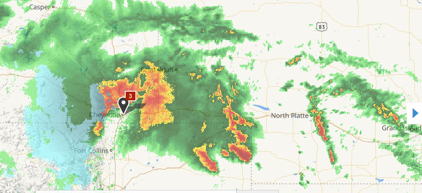
Some active weather out west...Flash Flood Watches in Wyoming...Severe Thunderstorm Watches in Nebraska and Kansas...Tornado Watch in Colorado.
Area of heavy rain and storms in Wyoming, Colorado, and Nebraska:
Tornado Warning in Colorado:
Quote:
THE NATIONAL WEATHER SERVICE IN GOODLAND HAS ISSUED A
* TORNADO WARNING FOR...
NORTHEASTERN YUMA COUNTY IN NORTHEASTERN COLORADO...
* UNTIL 730 PM MDT
* AT 657 PM MDT...A SEVERE THUNDERSTORM CAPABLE OF PRODUCING A TORNADO
WAS LOCATED 12 MILES WEST OF CRETE...OR 17 MILES SOUTHEAST OF
HOLYOKE...MOVING NORTH AT 20 MPH.
HAZARD...TORNADO AND PING PONG BALL SIZE HAIL.
SOURCE...RADAR INDICATED ROTATION. AT 650 PM MDT...QUARTER SIZE
HAIL WAS REPORTED 2 MILES NORTH OF ALVIN.
IMPACT...FLYING DEBRIS WILL BE DANGEROUS TO THOSE CAUGHT WITHOUT
SHELTER. MOBILE HOMES WILL BE DAMAGED OR DESTROYED.
DAMAGE TO ROOFS...WINDOWS...AND VEHICLES WILL OCCUR. TREE
DAMAGE IS LIKELY.
* THIS TORNADIC THUNDERSTORM WILL REMAIN OVER MAINLY RURAL AREAS OF
NORTHEASTERN YUMA COUNTY.
Winter Weather Advisories also in effect in Wyoming:
Quote:
...SNOW RETURNS TO THE SNOWY AND SIERRA MADRE RANGES TONIGHT...
.SNOW LEVELS WILL CONTINUE FALLING ACROSS THE SNOWY AND SIERRA
MADRE RANGES GRADUALLY TURNING RAIN OVER RAIN OVER TO SNOW. SNOW
LEVELS WILL REACH AROUND 7500 FEET TONIGHT. TOTAL SNOWFALL
ACCUMULATIONS OF 6 TO 10 INCHES ARE EXPECTED.
WYZ112-114-081200-
/O.NEW.KCYS.WW.Y.0026.160508T0000Z-160508T1800Z/
SIERRA MADRE RANGE-SNOWY RANGE-
INCLUDING THE CITIES OF...CENTENNIAL...ALBANY
239 PM MDT SAT MAY 7 2016
...WINTER WEATHER ADVISORY IN EFFECT FROM 6 PM THIS EVENING TO
NOON MDT SUNDAY...
THE NATIONAL WEATHER SERVICE IN CHEYENNE HAS ISSUED A WINTER
WEATHER ADVISORY FOR SNOW...WHICH IS IN EFFECT FROM 6 PM THIS
EVENING TO NOON MDT SUNDAY.
* TIMING...TONIGHT THROUGH SUNDAY MORNING.
* TOTAL SNOW ACCUMULATIONS...6 TO 10 INCHES.
* VISIBILITIES...WILL BE REDUCED TO ONE HALF MILE IN THE HEAVIEST
FALLING SNOW.
* IMPACTS...MAINLY TRAVEL DIFFICULTIES DUE TO LOW VISIBILITIES AND
AREAS OF SLICK AND SNOWPACKED ROADS.
Please register to post and access all features of our very popular forum. It is free and quick. Over $68,000 in prizes has already been given out to active posters on our forum. Additional giveaways are planned.
Detailed information about all U.S. cities, counties, and zip codes on our site: City-data.com.

 Please register to participate in our discussions with 2 million other members - it's free and quick! Some forums can only be seen by registered members. After you create your account, you'll be able to customize options and access all our 15,000 new posts/day with fewer ads.