Spring 2015 thread (Northern Hemisphere) (tornado, hot, recorded, temperature)
Please register to participate in our discussions with 2 million other members - it's free and quick! Some forums can only be seen by registered members. After you create your account, you'll be able to customize options and access all our 15,000 new posts/day with fewer ads.
If I'm not mistaken, isn't your suburb not actually part of the Chicago metro area but separated from it by 20 miles of farmland? Somewhere near Kankakee, right? Makes sense why it's always much warmer there.
Bourbonnais is in the northern edge of Kankakee County, which is part of Chicago CSA. It's considered a far suburb or exurb of Chicago. I'm 35 miles from the city limits, similar in relation to Chicago as is Joliet, Elgin, Aurora, Waukegan. We usually see warmer high temps in the spring and summer because we don't get lake cooling.
We are always considered part of the Chicago area as the graphic indicates
Btw...
Last edited by chicagogeorge; 05-24-2015 at 08:37 PM..
Texas has been very rainy and unusually cooler than I expected. The UT Austin graduation ceremony which I was to attend as a guest got canceled due to bad weather. We had a tornado sweep through south of Austin.
I also experienced a dew point of 78 F in San Antonio.
this is wrong. Raleigh's highest temp this year so far is 91. it has us at the 85-89 range. whoever made this map has many mistakes.
Yup, someone send that guy a message to re-run the data.
Here are the max temps so far this year. Wish AccuPro found a way to color code the map. I'm not a programmer or code expert so no idea how it would be done.
Only low 80s here so far. 91 in northern CT and NE PA looks like Scranton?
Most of 90s looks like North Carolina is the furthest north so far. Its not even June so not surprising. Wait a month and lets see how this looks again.
I think the two maps mostly agree. The first map is probably smoothing so one isolated temperature doesn't change the map.
I think the two maps mostly agree. The first map is probably smoothing so one isolated temperature doesn't change the map.
Look closer. 90s could of been stretched into Western NC and North more. Meanwhile they have the blob of 90s in Eastern Virginia.
SW Nebraska they got mid-upper 80s meanwhile should be low 80s. They even have too much 90s showing there. And there's been 90s in Eastern Nebraska meanwhile they don't have it showing. LOL
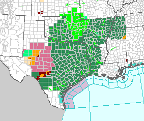
Flood watches remaining in effect in Texas, Oklahoma, Louisiana, and Arkansas. Now they're extending into Mississippi and Tennessee. Severe thunderstorm watches and warnings in Texas.
Please register to post and access all features of our very popular forum. It is free and quick. Over $68,000 in prizes has already been given out to active posters on our forum. Additional giveaways are planned.
Detailed information about all U.S. cities, counties, and zip codes on our site: City-data.com.

 Please register to participate in our discussions with 2 million other members - it's free and quick! Some forums can only be seen by registered members. After you create your account, you'll be able to customize options and access all our 15,000 new posts/day with fewer ads.