Please register to participate in our discussions with 2 million other members - it's free and quick! Some forums can only be seen by registered members. After you create your account, you'll be able to customize options and access all our 15,000 new posts/day with fewer ads.
The arrival of 70-deg temps are late and running way behind this year (NO surprise there). But the hours of sunlight are up nearly 4 hours and sun intensity in April is nearly 3.5 times stronger than in December. All tis bodes well for producing warmth more frequently.
85% of years have had a 70-deg or higher temp by April 8--and that includes last year with its 70-deg high on April 6. The average date for the city's first 70-deg temp is March 24 at O'Hare, March 26 at Midway and April 7 at the lakefront--dates which have all passed. But the news isn't bad at all. While we're NOT done with chilly weather just yet this spring, the warmest set of temps in 6 months are to occur in spurts over the coming 6 days. And we have a real shot at the year's first 70 this weekend. Check out details on the graphic feature being posted here off our WGN Chicago Weather Center blog.
"NE" winds off the lake limit shoreline warming Tuesday--but the well developed SSW flow forecast Wed into Thu will propel temps into the 60s for only the 2nd and 3rd time this year. And even warmer temps may occur this weekend--though we have wide model spreads on Sunday's temps, with our NWS GFS model bringing a front across the area and marginalizing warming while warmth sweeps in full throttle on the overnight European Center run with 70s predicted if that model verifies. (Check out that model's surface forecast below for 1pm this Sunday). So, we definitely have some issues to iron out in the days ahead as newer data becomes available. But, the current read is this weekend is likely to be Chicago's warmest in the 6 months since last Oct 12 & 13. I'm posting high temp forecasts for Wed, Sat & Sun off the European Center's model.
Also being monitored is the potential for spotty but respectable (in terms of the rain yield) over parts of the area Tuesday. I'm posting panels off the Weather Service's HRRR model depicting these convective showers which that model is clustering near the west end of the inland-propagating "NE" winds. And, the Gulf's to open wide and sends moisture streaming north by Sunday laying the foundation for some potentially significant rains and thunderstorms then.
Quote:
The variability of Chicago spring weather is legendary--particularly with chilly lake waters at our doorstep this time of year.
While significant warming appears a good bet for at least a chunk of the upcoming weekend, colder air is predicted to circulate back into the area early next week, courtesy of a buckling jet stream expected to drive below-normal temps back into the area. Some healthy rainfall, including thunderstorms, could precede and accompany the transition Sunday into Sunday night, with the potential for that precip to end as a wintry mix of precip.
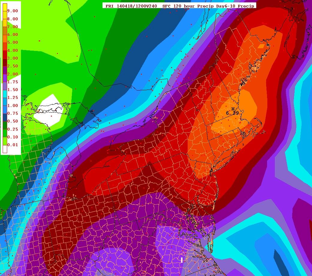
GFS12z says this much rain will fall Sun-Friday next week. (mostly from the 16-17th system)
That's a lot of rain in 5 days. Hoping its wrong and wont happen. Then again... let it all out now...
April showers bring May flowers is the saying around here..
I'm so ready for warmth weather! 60s likely today and tomorrow! Dry until Friday-Saturday. I love these Spring patterns. I think I'm done with the damp chilly weather now. Lets move on.
Whoa. I can't believe I'm reading this from you. Maybe you only hate hot weather?
I wasn't expecting warm weather. I was home till early afternoon, seemed kinda cool in the morning, didn't occur to me to open the windows.
GFS12z says this much rain will fall Sun-Friday next week. (mostly from the 16-17th system)
That's a lot of rain in 5 days. Hoping its wrong and wont happen. Then again... let it all out now...
April showers bring May flowers is the saying around here..
This would put us here in Top 10 wettest Aprils.
Rain is good. Should be better timed not to be on weekends.
Whoa. I can't believe I'm reading this from you. Maybe you only hate hot weather?
I wasn't expecting warm weather. I was home till early afternoon, seemed kinda cool in the morning, didn't occur to me to open the windows.
LOL. I figured someone would be shocked. Yeah, I do like those warm windy clear Spring days but has to be low dewpoints and temps under 70F and I don't mind. I don't prefer, but I don't mind. I get nostalgic thinking of my hockey days with the boys and it gives me a chance to clean the yard.
I love this area for the season change so lets change to Spring then change back to Fall in 3 months. Deal?
Quote:
Originally Posted by cloudcrash619
Looks to be a warm week and weekend ahead, but GFS gives me snow on Day 7 LOL. There should at least be a nice cool down though
Haha, I had to check out of curiosity. You're right! Looks like a cold pool lingers over the area Wed 16th. Both 925 and 850 level is below freezing for few hours, good timing because its early morning so surface is mid 30s.
But its so marginal, such light moisture, and not strong enough cold layer aloft to even be excited about. Keep us posted!
Please register to post and access all features of our very popular forum. It is free and quick. Over $68,000 in prizes has already been given out to active posters on our forum. Additional giveaways are planned.
Detailed information about all U.S. cities, counties, and zip codes on our site: City-data.com.

 Please register to participate in our discussions with 2 million other members - it's free and quick! Some forums can only be seen by registered members. After you create your account, you'll be able to customize options and access all our 15,000 new posts/day with fewer ads.


 . Summer = sunny and moderately humid weather for us.


