Please register to participate in our discussions with 2 million other members - it's free and quick! Some forums can only be seen by registered members. After you create your account, you'll be able to customize options and access all our 15,000 new posts/day with fewer ads.
Accuweather seems to think most of the frozen precip will stay north of the Tri-State area (NYC/NJ/CT) and be more a NY State interior New England event. He think by the time the cold air gets to places like NYC, New Haven, Trenton, NJ...etc all the precp will be gone.
NWS New York. Interesting Technical stuff. They are saying the cold air is 2'000-4,000 feet and that temps up at that level will be -3C by 7pm which supports heavy sleet in southern NY. Orange is well North of NYC.
The cold air is a bit stronger than some projected.
COLD "NOSE" IN LOW LEVELS AROUND 2-4K FT AGL LAYER WITH TEMPS OF
-3 TO -5 C BY 00Z AT KSWF SEEN IN 12Z NAM SOUNDING. THIS CLEARLY
SUPPORTS SLEET. IN FACT, MODERATE TO OCCASIONALLY HEAVY SLEET
NWS Louisville Kentucky received word from the Whitehouse to lower their flag to 1/2 staff for Nelson Mandela but they can't - it's frozen to the pole.
The Governor participated in a full storm briefing at 1 p.m. today with representatives from the National Weather Service, the State Police, the Virginia Department of Emergency Management, the Virginia Department of Transportation, the Virginia Department of Health, the Virginia National Guard, Dominion Virginia Power, and numerous other agencies and officials, including several members of his Cabinet
Based on the latest guidance we have received, it can be anticipated that all areas north and west of roughly Emporia to West Point to Lancaster County line will see some ice and snow beginning Sunday. After the start of the precipitation, the freezing line will begin to move inland, but there is much uncertainty regarding how far west it will get, and at what speed.
Winter Storm Sunday update: Light snow accumulations, then ice; changing to rain in some areas late Sunday night
* An inch or so of snow possible before change to ice late Sunday afternoon
* Ravens and Redskins play in snow and ice
* Area at risk of ice storm from Manassas to Fairfax to Rockville to Columbia and points west; looks to be particularly bad Harrisonburg, Winchester, Hagerstown
* Ice changes to rain along and east of I-95 between midnight and pre-dawn hours
A Cross Section of the Atmosphere. Lets take a ride from Columbus Ohio to Philly at 10pm tonight.
Start from the left its snowing in Columbus, as we drive along on a straight path to Philly we get to the mountains... Notice the air above start to get warmer. Sleet is falling in PA then all layers are warm over PHL.
Lets go from Burlington Vermont to the CT coast now. Too dry over BTV. Moisture gets deeper as you drive south.. Notice the cold nose couple thousand feet up Upton mentioned.
"East River effect snow" would be a health hazard here.
LOL. Maybe the Hudson too in Southern NY. But yeah, I never heard of that myself, maybe once or twice but not something we hear everyday. We hear about Lakes and even Ocean effect snows a lot.
Rivers are just another body of water. It Doesn't matter what the Ocean, Lake, or River temps are, its the air that counts.
The air above will do what it wants no matter what the body of water is. You throw some cold air over top warm water and you get that to happen.. It also creates a tight thermal gradient which helps enhance moisture. That's why its fun living near the ocean. Get that cold air in place and a Low pressure system tracked right and Let it snow.
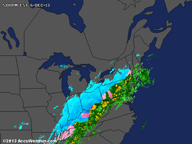
Radar Loop. Lots of moisture out there and seeing some really heavy returns in spots.
Changeover happening in PA now. Snowing in Pittsburg and freezing rain as you move West.
Please register to post and access all features of our very popular forum. It is free and quick. Over $68,000 in prizes has already been given out to active posters on our forum. Additional giveaways are planned.
Detailed information about all U.S. cities, counties, and zip codes on our site: City-data.com.

 Please register to participate in our discussions with 2 million other members - it's free and quick! Some forums can only be seen by registered members. After you create your account, you'll be able to customize options and access all our 15,000 new posts/day with fewer ads.