Please register to participate in our discussions with 2 million other members - it's free and quick! Some forums can only be seen by registered members. After you create your account, you'll be able to customize options and access all our 15,000 new posts/day with fewer ads.
Polar Jet... Meet Sub Tropical Jet.... Nice to meet you.
Latest GFS has a memorable snowstorm for the Upper Mid West towards the end of the month. It keeps a persistant Trough in the West with a Ridge in the East so temps warm up in the Mississippi valley on this run..
Do I believe this snowstorm? Well lets just say... #1. Its the GFS. #2. Its medium range not short range. #3. It's the first time Im seeing it. So the quick answer is NO.. Not yet.
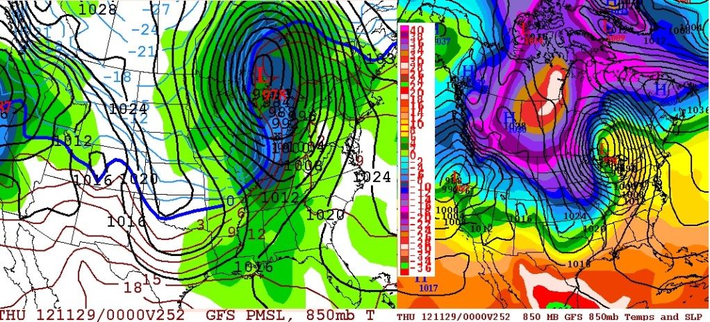
Look at the 850mb temps in part of Canada there! -26°C (-14F°) Single digits bleed down into the U.S
Anyone with a home weather station or barometer notice the high pressure the last two days, especially this morning? This graphic displays an analysis of the sea level pressure across much of the nation on this Sunday morning. One aspect that stands out is how high the sea level pressure is across the eastern United States and southeast Canada. A 1043 millibar (mb) high pressure is situated near Northern Vermont, New Hampshire, and Maine. Sea level pressure values across our service area this morning are from 1038 to 1040 mb! These stronger surface high pressure systems are more common to occur during the late fall and winter months. As a reference, the standard atmosphere sea level pressure is about 1013 mb
2C with pouring rain? If it could get just a bit colder it might snow.
It probably wouldn't. The humdity would just rise because in order for it to cool down it needs to rain lotswhich means increased humidity, in siutations like this I've seen it rain as low as 0.4c- humidity was 99 and it took the temperature to drop to 0.1c to snow. Dosnt matter anyway as it's going to warm up later tonight.
Here's what the most recent run of the GFS shows for the Sunday the 25th.
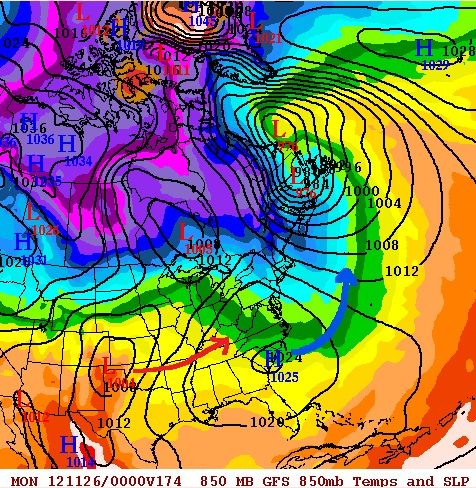
Dry in the East High pressure down in the southeast pumping some nice warm air, small trough in the northeast keeping them seasonable, zonal flow for the west, notice the low pressure over Texas.... That High pressure will move East into the Atlantic making room for that Low to move across
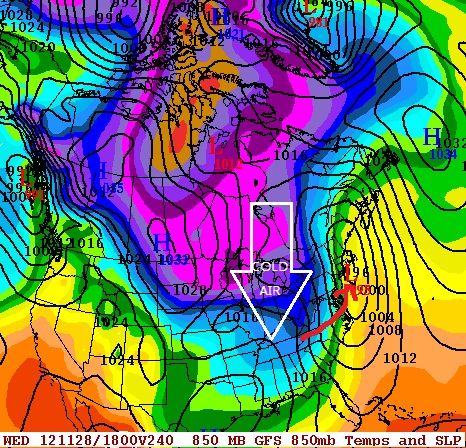
Wednesday the 28th. Notice the Low pressure now. It basically exits off the coast and heads up the coast as it strengthens. Weak system but also notice the cold air pouring down from Canada. Northern Tier of Northeast gets some snow from this. We'll have to see if this countinues..
It probably wouldn't. The humdity would just rise because in order for it to cool down it needs to rain lotswhich means increased humidity, in siutations like this I've seen it rain as low as 0.4c- humidity was 99 and it took the temperature to drop to 0.1c to snow. Dosnt matter anyway as it's going to warm up later tonight.
Do you get freezing rain at times? When a warm front come by after some below average temps, you hope for some transient snow and all you get is rain even though it's -2°C. Dangerous on top of that.
I've read about rain at -10°C in Quebec.
Freezing rain is something I have never experienced, or have any memories of experiencing. I recall one night after the Dec 2010 cold spell, I think it was early Jan, and we were forecast snow, it was 1C, and I hoped it would snow.. but it poured with rain. 1C and pouring rain. That is really horrible.
Uppers are really important when it comes to snowfall, as well as dew points and intensity of the rain. If the rain is heavy enough, it may allow for evaporative cooling.
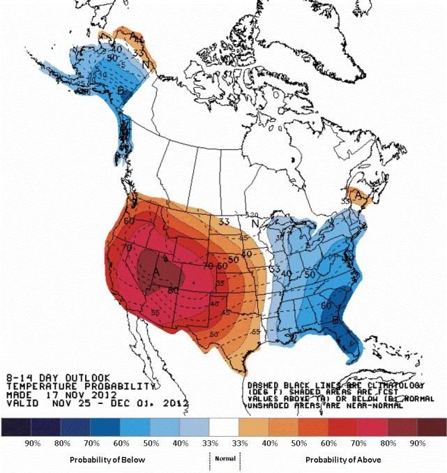
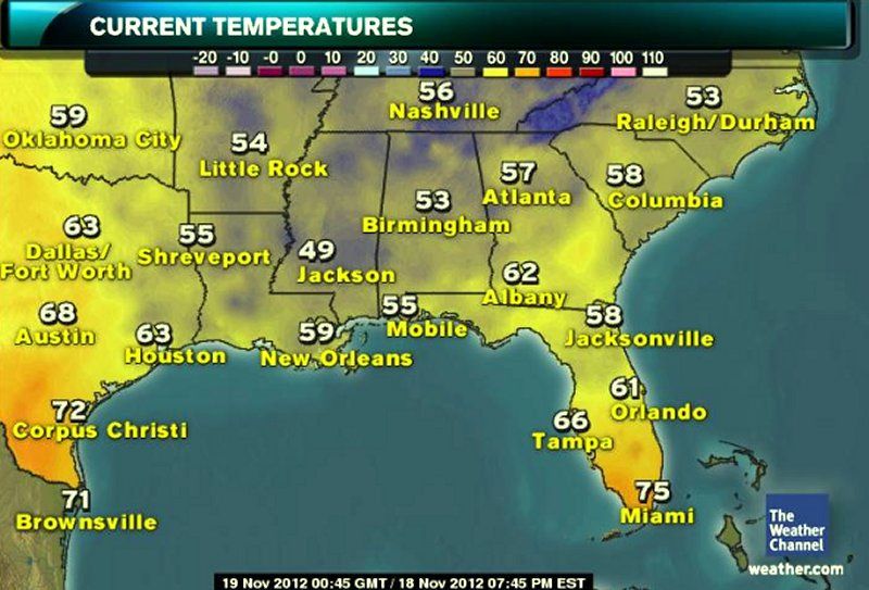
As promised folks...the cold departures are vaporizing....a nice early evening in the southern tier from Cailiforina east to the lower Atlantic coast. All this warm air is heading toward you guys up in the Midwest and Northeast. NYC and Washington DC could see near 60 F Thanksgiving day, while Denver will hit over 65. Miami and LA should make 80 and 70 respectively Thanksgiving day:
Please register to post and access all features of our very popular forum. It is free and quick. Over $68,000 in prizes has already been given out to active posters on our forum. Additional giveaways are planned.
Detailed information about all U.S. cities, counties, and zip codes on our site: City-data.com.

 Please register to participate in our discussions with 2 million other members - it's free and quick! Some forums can only be seen by registered members. After you create your account, you'll be able to customize options and access all our 15,000 new posts/day with fewer ads.


 (-14F°) Single digits bleed down into the U.S