Please register to participate in our discussions with 2 million other members - it's free and quick! Some forums can only be seen by registered members. After you create your account, you'll be able to customize options and access all our 15,000 new posts/day with fewer ads.
But, erm wouldn't it be nice to see several feet of snow?
It would, but where nei lives he's buried in snow from at least late November onwards I don't know if that's actually true, I'm just going by stereotypes. Nei will see snow this winter, snow in the northeast US is as sure as cloudiness in Britain
But, erm wouldn't it be nice to see several feet of snow?
It would be interesting to see, but not really worth the hassle of a trip, which would probably be dangerous (lots of downed trees, some flooded roads). In any case, there'll be plenty of snow in the winter though not several feet at once. The mountains and some of the hills much closer to home will get several feet on snowpack though maybe not from one storm.
It would, but where nei lives he's buried in snow from at least late November onwards I don't know if that's actually true, I'm just going by stereotypes. Nei will see snow this winter, snow in the northeast US is as sure as cloudiness in Britain
Yes, well I don't think he is buried in the amount of snow that is predicted.
Snow sublimes. I remember in 2010 I had a foot and by 6 weeks it was down to like 5 inches.
NWS thinks that only elevations above 2000 ft will see snow on the back side, not really from Hurricane Sandy but from the trough to the west interacting with the remant storm (by then). A 6 hr 300 mile drive is a long way to go for the "chance" to see snow - lol.
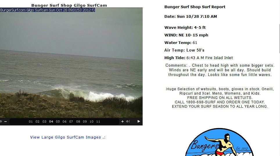
Meanwhile,,,the waves are building south of Long Island:
Jeff Master's give the storm a 50% chance of flooding the NYC subway system. Storm surge predicted to be several feet higher than Irene (6-9 feet?) and pour over the Manhattan flood walls. I've always wondered when this will be repeated:
The hurricane produced a storm surge of 13 feet (4 m) in only one hour at Battery Park. Manhattan Island was completely flooded to Canal Street [the entire downtown district]; one hurricane researcher remarked that the storm surge flooding would have been much worse, had the hurricane not struck at low tide.
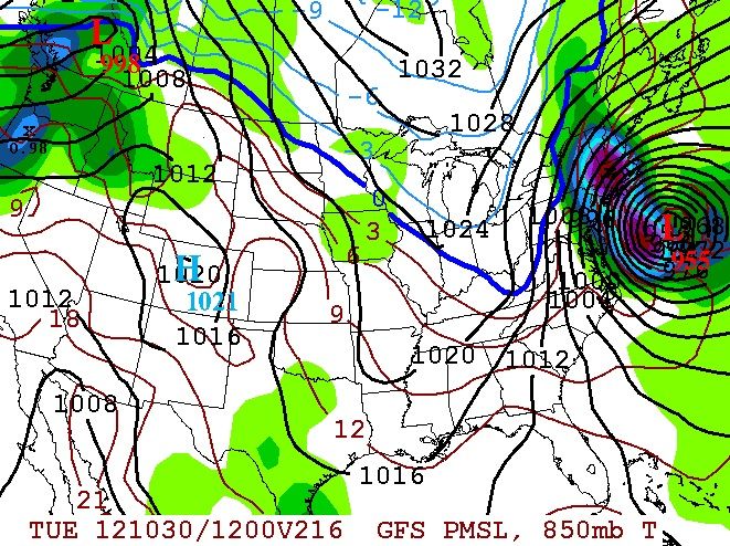
Storm is the largest in area recorded in the Atlantic. Forecast pressure is 945-1000 mb. Anyone know why the pressure is low but the wind speed not so high? Is it because the spread is so wide that the winds are weaker for spreading over a larger area?
NWS thinks that only elevations above 2000 ft will see snow on the back side, not really from Hurricane Sandy but from the trough to the west interacting with the remant storm (by then). A 6 hr 300 mile drive is a long way to go for the "chance" to see snow - lol.
Meanwhile,,,the waves are building south of Long Island:
Thats not me.
I thought this hurricane was going to produce several feet of snow. So thats why I said so..
It wasn't me who said that another member said that.
I would never drive to see snow because I have high hills right behind my house.. And erm we had snow on Friday so.
It would, but where nei lives he's buried in snow from at least late November onwards I don't know if that's actually true, I'm just going by stereotypes. Nei will see snow this winter, snow in the northeast US is as sure as cloudiness in Britain
We have snow on the ground more than not over the winter, and enough to rain to periodically melt all the snow on the ground. Our average is around 4 feet / season, but it varies.
The first half of December is usually bare, and often no significant snowstorms. Max snow depth recorded was around 36" so no burying .
High Wind Warning now in effect. Should be interesting if the hurricane force wind gusts verify. I'll be spending the storm in NE New Jersey about 30 miles outside of NYC.
Reposting this... Got it nearly right 9 days in advance.
Quote:
Originally Posted by Cambium
? Not believing it still but a few more times showing a Hurricane on the coast and my confidence grows.
To give some credit to the GFS, it was showing a Tropical System come from the Pacific and cross down south and come up the coast.. Now its showing a Hurricane in Atlantic blow up on the coast.
So to me that is a signal that something could happen along the coast.. It's picking up an enviroment favoring this.
This would be the Nov. 1st time frame. It actually stalls it too. (never a good thing)
Put it this way...Irene was a 973mb Low.
GFS12z
Please register to post and access all features of our very popular forum. It is free and quick. Over $68,000 in prizes has already been given out to active posters on our forum. Additional giveaways are planned.
Detailed information about all U.S. cities, counties, and zip codes on our site: City-data.com.

 Please register to participate in our discussions with 2 million other members - it's free and quick! Some forums can only be seen by registered members. After you create your account, you'll be able to customize options and access all our 15,000 new posts/day with fewer ads.

 I don't know if that's actually true, I'm just going by stereotypes. Nei will see snow this winter, snow in the northeast US is as sure as cloudiness in Britain