Bridge Statistics for Tulsa, Oklahoma (OK)
Condition, Traffic, Stress, Structural Evaluation, Project Costs
- National Bridge Inventory (NBI) Statistics
- 1,018Number of bridges
- 12,605ft / 3,842mTotal length
- $1,477,519,000Total costs
- 19,139,960Total average daily traffic
- 1,822,874Total average daily truck traffic
- National Bridge Inventory (NBI) Registered Bridges for Tulsa
- No street view available for this location
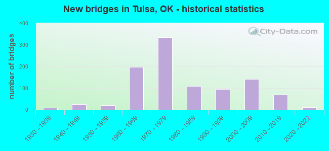
- New bridges - historical statistics
- 11910-1919
- 11920-1929
- 91930-1939
- 261940-1949
- 221950-1959
- 1971960-1969
- 3341970-1979
- 1101980-1989
- 961990-1999
- 1422000-2009
- 692010-2019
- 112020-2022
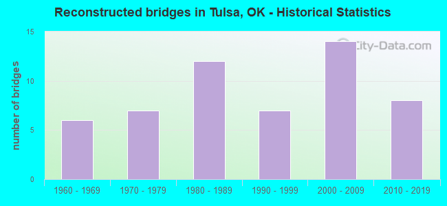
- Reconstructed bridges - Historical Statistics
- 61960-1969
- 71970-1979
- 121980-1989
- 71990-1999
- 142000-2009
- 82010-2019
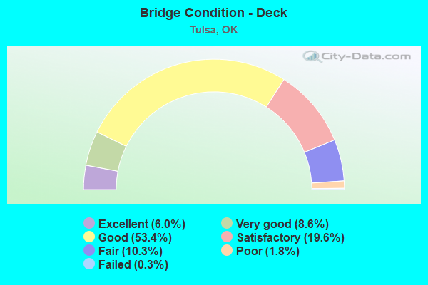
- Bridge Condition - Deck
- 6.0%Excellent
- 8.6%Very good
- 53.4%Good
- 19.6%Satisfactory
- 10.3%Fair
- 1.8%Poor
- 0.3%Failed
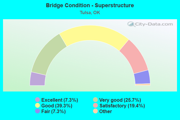
- Bridge Condition - Superstructure
- 7.3%Excellent
- 25.7%Very good
- 39.3%Good
- 19.4%Satisfactory
- 7.3%Fair
- 1.0%Poor
- 0.3%Critical
- 0.3%Failed
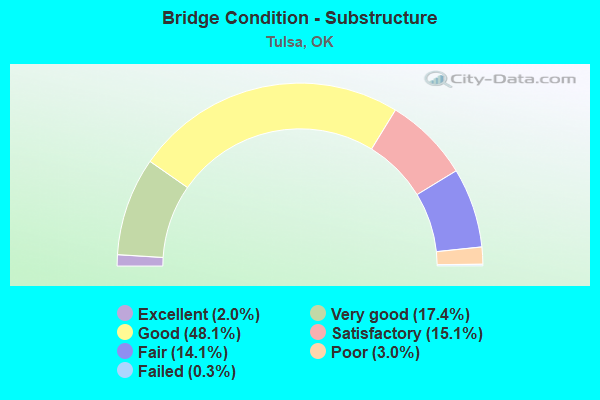
- Bridge Condition - Substructure
- 2.0%Excellent
- 17.4%Very good
- 48.1%Good
- 15.1%Satisfactory
- 14.1%Fair
- 3.0%Poor
- 0.3%Failed
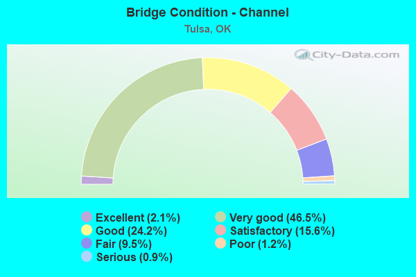
- Bridge Condition - Channel
- 2.1%Excellent
- 46.5%Very good
- 24.2%Good
- 15.6%Satisfactory
- 9.5%Fair
- 1.2%Poor
- 0.9%Serious
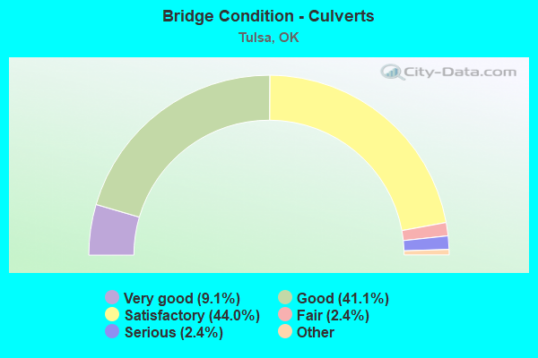
- Bridge Condition - Culverts
- 9.1%Excellent
- 41.1%Very good
- 44.0%Good
- 2.4%Satisfactory
- 2.4%Fair
- 1.0%Poor
- 2.4%Serious
Find on map >> Show street view
Structure Number: 18564, Location: 11.2 MI S-E OSAGE CO (Lat: 36.151944, Lng: -96.065278), Route carried "on" structure: City street , Year Built: 1973, Status: Open, Structure Length: 6.16m (20.21ft), Average Daily Traffic: 4,100 (year 2020), Truck Traffic: 5%, Average Future Daily Traffic: 6,560 (year 2040), Design Load: HS 20, Features Intersected: U.S. 64 UNDER, Facility Carried by Structure: 65TH W AVE.
Minimum Vertical Clearance: 30+ m (98+ ft), Kilometerpoint: 18.132, Lanes on structure: 5, Lanes under structure: 6, Owner: State Highway Agency, Approaching Roadway Width: 23.5m (77.1ft), Skew: 23 degrees, Material/Design: Steel continuous, Design/Construction: Stringer/Multi-beam, Number Of Spans In Main Unit: 2, Length of Maximum Span: 30.5m (100.1ft), Curb or Sidewalk Widths: Left: 1.5m (4.9ft), Right: 1.5m (4.9ft), Curb-To-Curb Width: 20.4m (66.9ft), Out-to-Out Width: 24.0m (78.7ft)
Condition: Deck: Good, Superstructure: Fair, Substructure: Good, Operating Rating: 48.2 metric tons, Method Used To Determine Operating Rating: Load and Resistance Factor (LRFR), Inventory Rating: 37.2 metric tons, Method Used To Determine Inventory Rating: Load and Resistance Factor (LRFR), Structural Evaluation: Somewhat better than minimum adequacy, Deck Geometry: Somewhat better than minimum adequacy, Underclear: High priority of replacement, Approach Roadway Alignment: Equal to present desirable criteria, Length Of Structure Improvement: 10.60m (34.78ft), Designated Inspection Frequency: Every 24 months, Inspection Date: October 2020, Bridge Improvement Cost: $2,720,000, Roadway Improvement Cost: $4,487,000, Total Project Cost: $7,615,000 ( Estimate for 2015), Deck Structure Type: Concrete Cast-file-Place, Wearing Surface/Protective System: Wearing Surface: Monolithic Concrete
Find on map >> Show street view
Structure Number: 18594, Location: 14.1 MI S-E OSAGE CO (Lat: 36.155556, Lng: -96.011389), Route carried "on" structure: City street , Year Built: 1973, Status: Open, Structure Length: 9.30m (30.51ft), Average Daily Traffic: 5,000 (year 2020), Truck Traffic: 5%, Average Future Daily Traffic: 8,000 (year 2040), Design Load: HS 20, Features Intersected: U.S. 64 UNDER, Facility Carried by Structure: UNION AVE.
Minimum Vertical Clearance: 30+ m (98+ ft), Kilometerpoint: 23.298, Lanes on structure: 2, Lanes under structure: 8, Owner: State Highway Agency, Approaching Roadway Width: 7.9m (25.9ft), Material/Design: Steel continuous, Design/Construction: Stringer/Multi-beam, Number Of Spans In Main Unit: 3, Length of Maximum Span: 32.0m (105.0ft), Curb or Sidewalk Widths: Left: 1.5m (4.9ft), Right: 1.5m (4.9ft), Curb-To-Curb Width: 7.9m (25.9ft), Out-to-Out Width: 11.5m (37.7ft)
Condition: Deck: Satisfactory, Superstructure: Good, Substructure: Good, Operating Rating: 56.0 metric tons, Method Used To Determine Operating Rating: Load Factor (LF), Inventory Rating: 33.6 metric tons, Method Used To Determine Inventory Rating: Load Factor (LF), Structural Evaluation: Better than present minimum criteria, Deck Geometry: High priority of corrective action, Underclear: Meets minimum limits, Approach Roadway Alignment: Equal to present desirable criteria, Length Of Structure Improvement: 9.86m (32.35ft), Designated Inspection Frequency: Every 24 months, Inspection Date: October 2020, Bridge Improvement Cost: $2,404,000, Roadway Improvement Cost: $3,967,000, Total Project Cost: $6,731,000 ( Estimate for 2015), Deck Structure Type: Concrete Cast-file-Place, Wearing Surface/Protective System: Wearing Surface: Monolithic Concrete
Find on map >> Show street view
Structure Number: 18636, Location: 5200 S 129 E AVE (Lat: 36.086964, Lng: -95.833333), Route carried "on" structure: City street 8461, Year Built: 1974, Status: Open, Structure Length: 0.98m (3.22ft), Average Daily Traffic: 17,800 (year 2020), Truck Traffic: 5%, Average Future Daily Traffic: 28,480 (year 2040), Design Load: HS 20, Features Intersected: FORD CREEK
Minimum Vertical Clearance: 30+ m (98+ ft), Kilometerpoint: 7.884, Lanes on structure: 4, Owner: City or Municipal Highway Agency, Approaching Roadway Width: 19.5m (64.0ft), Material/Design: Concrete, Design/Construction: Culvert, Number Of Spans In Main Unit: 3, Length of Maximum Span: 3.0m (9.8ft), Curb or Sidewalk Widths: Left: 2.2m (7.2ft), Right: 0.0m
Condition: Channel: Satisfactory, Culverts: Good, Operating Rating: 42.6 metric tons, Method Used To Determine Operating Rating: Load Factor (LF), Inventory Rating: 32.7 metric tons, Method Used To Determine Inventory Rating: Load Factor (LF), Structural Evaluation: Better than present minimum criteria, Waterway Adequacy: Better than present minimum criteria, Approach Roadway Alignment: Equal to present desirable criteria, Length Of Structure Improvement: 3.52m (11.55ft), Designated Inspection Frequency: Every 24 months, Inspection Date: May 2020, Bridge Improvement Cost: $100,000, Roadway Improvement Cost: $75,000, Total Project Cost: $225,000 ( Estimate for 2015)
Find on map >> Show street view
Structure Number: 18646, Location: 4000 E 84ST (Lat: 36.040714, Lng: -95.932539), Route carried "on" structure: City street E0674, Year Built: 1974, Status: Open, Structure Length: 0.96m (3.15ft), Average Daily Traffic: 500 (year 2020), Truck Traffic: 5%, Average Future Daily Traffic: 800 (year 2040), Design Load: HS 20, Features Intersected: VENSEL CREEK
Minimum Vertical Clearance: 30+ m (98+ ft), Kilometerpoint: 0.644, Lanes on structure: 2, Owner: City or Municipal Highway Agency, Approaching Roadway Width: 11.0m (36.1ft), Material/Design: Concrete, Design/Construction: Culvert, Number Of Spans In Main Unit: 3, Length of Maximum Span: 3.0m (9.8ft), Curb-To-Curb Width: 11.0m (36.1ft), Out-to-Out Width: 14.6m (47.9ft)
Condition: Channel: Good, Culverts: Good, Operating Rating: 42.6 metric tons, Method Used To Determine Operating Rating: Load Factor (LF), Inventory Rating: 32.7 metric tons, Method Used To Determine Inventory Rating: Load Factor (LF), Structural Evaluation: Better than present minimum criteria, Deck Geometry: Better than present minimum criteria, Waterway Adequacy: Better than present minimum criteria, Approach Roadway Alignment: Equal to present desirable criteria, Length Of Structure Improvement: 3.52m (11.55ft), Designated Inspection Frequency: Every 24 months, Inspection Date: May 2020, Bridge Improvement Cost: $100,000, Roadway Improvement Cost: $75,000, Total Project Cost: $225,000 ( Estimate for 2015)
Find on map >> Show street view
Structure Number: 18647, Location: 10200 E 55 PL. (Lat: 36.083533, Lng: -95.862681), Route carried "on" structure: City street E0644, Year Built: 1974, Status: Open, Structure Length: 1.15m (3.77ft), Average Daily Traffic: 3,000 (year 2020), Truck Traffic: 5%, Average Future Daily Traffic: 4,800 (year 2040), Design Load: HS 20, Features Intersected: MINGO CREEK
Minimum Vertical Clearance: 30+ m (98+ ft), Kilometerpoint: 0.483, Lanes on structure: 2, Owner: City or Municipal Highway Agency, Approaching Roadway Width: 11.3m (37.1ft), Material/Design: Concrete, Design/Construction: Culvert, Number Of Spans In Main Unit: 3, Length of Maximum Span: 3.7m (12.1ft)
Condition: Channel: Very good, Culverts: Satisfactory, Operating Rating: 42.6 metric tons, Method Used To Determine Operating Rating: Load Factor (LF), Inventory Rating: 32.7 metric tons, Method Used To Determine Inventory Rating: Load Factor (LF), Structural Evaluation: Equal to present minimum criteria, Waterway Adequacy: Better than present minimum criteria, Approach Roadway Alignment: Equal to present desirable criteria, Length Of Structure Improvement: 3.73m (12.24ft), Designated Inspection Frequency: Every 24 months, Inspection Date: May 2020, Bridge Improvement Cost: $100,000, Roadway Improvement Cost: $75,000, Total Project Cost: $225,000 ( Estimate for 2015)
Find on map >> Show street view
Structure Number: 18648, Location: 10700 E 55 PL. (Lat: 36.083533, Lng: -95.858567), Route carried "on" structure: City street E0645, Year Built: 1974, Status: Open, Structure Length: 0.98m (3.22ft), Average Daily Traffic: 300 (year 2020), Truck Traffic: 10%, Average Future Daily Traffic: 480 (year 2040), Design Load: HS 20, Features Intersected: CATFISH CREEK
Minimum Vertical Clearance: 30+ m (98+ ft), Kilometerpoint: 0.966, Lanes on structure: 2, Owner: City or Municipal Highway Agency, Approaching Roadway Width: 11.3m (37.1ft), Skew: 1 degrees, Material/Design: Concrete, Design/Construction: Culvert, Number Of Spans In Main Unit: 3, Length of Maximum Span: 3.0m (9.8ft)
Condition: Channel: Very good, Culverts: Good, Operating Rating: 42.6 metric tons, Method Used To Determine Operating Rating: Load Factor (LF), Inventory Rating: 32.7 metric tons, Method Used To Determine Inventory Rating: Load Factor (LF), Structural Evaluation: Better than present minimum criteria, Waterway Adequacy: Better than present minimum criteria, Approach Roadway Alignment: Equal to present desirable criteria, Length Of Structure Improvement: 3.41m (11.19ft), Designated Inspection Frequency: Every 24 months, Inspection Date: May 2020, Bridge Improvement Cost: $100,000, Roadway Improvement Cost: $75,000, Total Project Cost: $225,000 ( Estimate for 2015)
Find on map >> Show street view
Structure Number: 18717, Location: 4000 S 103 E AVE (Lat: 36.106475, Lng: -95.862550), Route carried "on" structure: City street N4002, Year Built: 1974, Status: Open, Structure Length: 3.66m (12.01ft), Average Daily Traffic: 1,472 (year 2020), Truck Traffic: 5%, Average Future Daily Traffic: 2,355 (year 2040), Design Load: HS 20, Features Intersected: MINGO CREEK, Facility Carried by Structure: S 103RD E AVE.
Minimum Vertical Clearance: 30+ m (98+ ft), Kilometerpoint: 1.448, Lanes on structure: 2, Owner: City or Municipal Highway Agency, Approaching Roadway Width: 11.0m (36.1ft), Material/Design: Prestressed concrete, Design/Construction: Stringer/Multi-beam, Number Of Spans In Main Unit: 2, Length of Maximum Span: 18.3m (60.0ft), Curb or Sidewalk Widths: Left: 1.5m (4.9ft), Right: 1.5m (4.9ft), Curb-To-Curb Width: 11.0m (36.1ft), Out-to-Out Width: 14.6m (47.9ft)
Condition: Deck: Satisfactory, Superstructure: Good, Substructure: Fair, Channel: Fair, Operating Rating: 61.7 metric tons, Method Used To Determine Operating Rating: Load Factor (LF), Inventory Rating: 36.3 metric tons, Method Used To Determine Inventory Rating: Load Factor (LF), Structural Evaluation: Somewhat better than minimum adequacy, Deck Geometry: Equal to present minimum criteria, Waterway Adequacy: Equal to present desirable criteria, Approach Roadway Alignment: Equal to present desirable criteria, Length Of Structure Improvement: 6.86m (22.51ft), Designated Inspection Frequency: Every 24 months, Inspection Date: November 2020, Bridge Improvement Cost: $351,000, Roadway Improvement Cost: $193,000, Total Project Cost: $560,000 ( Estimate for 2015), Deck Structure Type: Concrete Cast-file-Place, Wearing Surface/Protective System: Wearing Surface: Monolithic Concrete
Find on map >> Show street view
Structure Number: 18754, Location: 1.6 MI N I-44 (Lat: 36.104444, Lng: -96.020556), Route carried "on" structure: City street , Year Built: 1974, Status: Open, Structure Length: 6.46m (21.19ft), Average Daily Traffic: 5,000 (year 2020), Truck Traffic: 5%, Average Future Daily Traffic: 8,000 (year 2040), Design Load: HS 20, Features Intersected: I-244 UNDER, Facility Carried by Structure: 41ST ST.& S.W.BLVD
Minimum Vertical Clearance: 30+ m (98+ ft), Kilometerpoint: 2.573, Lanes on structure: 4, Lanes under structure: 4, Owner: State Highway Agency, Approaching Roadway Width: 18.9m (62.0ft), Skew: 25 degrees, Material/Design: Steel continuous, Design/Construction: Stringer/Multi-beam, Number Of Spans In Main Unit: 2, Length of Maximum Span: 32.3m (106.0ft), Curb or Sidewalk Widths: Left: 1.5m (4.9ft), Right: 1.5m (4.9ft), Curb-To-Curb Width: 18.9m (62.0ft), Out-to-Out Width: 22.5m (73.8ft)
Condition: Deck: Satisfactory, Superstructure: Satisfactory, Substructure: Fair, Operating Rating: 56.4 metric tons, Method Used To Determine Operating Rating: Load Factor (LF), Inventory Rating: 33.8 metric tons, Method Used To Determine Inventory Rating: Load Factor (LF), Structural Evaluation: Somewhat better than minimum adequacy, Deck Geometry: Equal to present minimum criteria, Underclear: High priority of replacement, Approach Roadway Alignment: Equal to present desirable criteria, Length Of Structure Improvement: 11.96m (39.24ft), Designated Inspection Frequency: Every 24 months, Inspection Date: September 2020, Bridge Improvement Cost: $2,609,000, Roadway Improvement Cost: $4,305,000, Total Project Cost: $7,305,000 ( Estimate for 2015), Deck Structure Type: Concrete Cast-file-Place, Wearing Surface/Protective System: Wearing Surface: Bituminous
Find on map >> Show street view
Structure Number: 18755, Location: 0.8 MI N I-44 (Lat: 36.097181, Lng: -96.029761), Route carried "on" structure: Interstate 244, Year Built: 1974, Status: Open, Structure Length: 6.42m (21.06ft), Average Daily Traffic: 9,850 (year 2020), Truck Traffic: 12%, Average Future Daily Traffic: 15,760 (year 2040), Design Load: HS 20, Features Intersected: 33 ST. UNDER
Minimum Vertical Clearance: 30+ m (98+ ft), Kilometerpoint: 1.432, Lanes on structure: 2, Lanes under structure: 6, Base Highway Network: Yes, Owner: State Highway Agency, Approaching Roadway Width: 12.4m (40.7ft), Skew: 14 degrees, Material/Design: Steel continuous, Design/Construction: Stringer/Multi-beam, Number Of Spans In Main Unit: 2, Length of Maximum Span: 32.0m (105.0ft), Curb-To-Curb Width: 12.4m (40.7ft), Out-to-Out Width: 13.3m (43.6ft)
Condition: Deck: Good, Superstructure: Good, Substructure: Good, Operating Rating: 54.7 metric tons, Method Used To Determine Operating Rating: Load Factor (LF), Inventory Rating: 32.8 metric tons, Method Used To Determine Inventory Rating: Load Factor (LF), Structural Evaluation: Better than present minimum criteria, Deck Geometry: Better than present minimum criteria, Underclear: Meets minimum limits, Approach Roadway Alignment: Equal to present desirable criteria, Length Of Structure Improvement: 9.86m (32.35ft), Designated Inspection Frequency: Every 24 months, Inspection Date: September 2020, Bridge Improvement Cost: $1,265,000, Roadway Improvement Cost: $2,088,000, Total Project Cost: $3,543,000 ( Estimate for 2015), Deck Structure Type: Concrete Cast-file-Place, Wearing Surface/Protective System: Wearing Surface: Monolithic Concrete, Membrane: Epoxy, Deck Protection: Epoxy Coated Reinforcing
Find on map >> Show street view
Structure Number: 18756, Location: 0.8 MI N I-44 (Lat: 36.097625, Lng: -96.029756), Route carried "on" structure: Interstate 244, Year Built: 1974, Status: Open, Structure Length: 6.42m (21.06ft), Average Daily Traffic: 10,350 (year 2020), Truck Traffic: 12%, Average Future Daily Traffic: 16,560 (year 2040), Design Load: HS 20, Features Intersected: 33 ST. UNDER
Minimum Vertical Clearance: 30+ m (98+ ft), Kilometerpoint: 1.432, Lanes on structure: 2, Lanes under structure: 6, Base Highway Network: Yes, Owner: State Highway Agency, Approaching Roadway Width: 16.5m (54.1ft), Skew: 14 degrees, Material/Design: Steel continuous, Design/Construction: Stringer/Multi-beam, Number Of Spans In Main Unit: 2, Length of Maximum Span: 32.0m (105.0ft), Curb-To-Curb Width: 12.4m (40.7ft), Out-to-Out Width: 13.3m (43.6ft)
Condition: Deck: Good, Superstructure: Good, Substructure: Good, Operating Rating: 54.7 metric tons, Method Used To Determine Operating Rating: Load Factor (LF), Inventory Rating: 32.8 metric tons, Method Used To Determine Inventory Rating: Load Factor (LF), Structural Evaluation: Better than present minimum criteria, Deck Geometry: Better than present minimum criteria, Underclear: Meets minimum limits, Approach Roadway Alignment: Equal to present desirable criteria, Length Of Structure Improvement: 9.86m (32.35ft), Designated Inspection Frequency: Every 24 months, Inspection Date: September 2020, Bridge Improvement Cost: $1,265,000, Roadway Improvement Cost: $2,088,000, Total Project Cost: $3,543,000 ( Estimate for 2015), Deck Structure Type: Concrete Cast-file-Place, Wearing Surface/Protective System: Wearing Surface: Monolithic Concrete, Membrane: Epoxy, Deck Protection: Epoxy Coated Reinforcing
Find on map >> Show street view
Structure Number: 18836, Location: 9500 E 55 ST. (Lat: 36.085117, Lng: -95.871103), Route carried "on" structure: City street E0643, Year Built: 1975, Status: Open, Structure Length: 0.79m (2.59ft), Average Daily Traffic: 640 (year 2020), Truck Traffic: 5%, Average Future Daily Traffic: 1,024 (year 2040), Design Load: HS 20, Features Intersected: ALSUMA CREEK
Minimum Vertical Clearance: 30+ m (98+ ft), Kilometerpoint: 0.483, Lanes on structure: 2, Owner: City or Municipal Highway Agency, Approaching Roadway Width: 11.0m (36.1ft), Material/Design: Concrete, Design/Construction: Culvert, Number Of Spans In Main Unit: 3, Length of Maximum Span: 2.4m (7.9ft)
Condition: Channel: Very good, Culverts: Satisfactory, Operating Rating: 42.6 metric tons, Method Used To Determine Operating Rating: Load Factor (LF), Inventory Rating: 32.7 metric tons, Method Used To Determine Inventory Rating: Load Factor (LF), Structural Evaluation: Equal to present minimum criteria, Waterway Adequacy: Better than present minimum criteria, Approach Roadway Alignment: Equal to present desirable criteria, Length Of Structure Improvement: 2.98m (9.78ft), Designated Inspection Frequency: Every 24 months, Inspection Date: May 2020, Bridge Improvement Cost: $100,000, Roadway Improvement Cost: $75,000, Total Project Cost: $225,000 ( Estimate for 2015)
Find on map >> Show street view
Structure Number: 18837, Location: 9500 E 54 ST. (Lat: 36.086717, Lng: -95.869756), Route carried "on" structure: City street E0642, Year Built: 1975, Status: Open, Structure Length: 0.79m (2.59ft), Average Daily Traffic: 830 (year 2020), Truck Traffic: 5%, Average Future Daily Traffic: 1,328 (year 2040), Design Load: HS 20, Features Intersected: ALSUMA CREEK
Minimum Vertical Clearance: 30+ m (98+ ft), Kilometerpoint: 0.483, Lanes on structure: 2, Owner: City or Municipal Highway Agency, Approaching Roadway Width: 11.0m (36.1ft), Material/Design: Concrete, Design/Construction: Culvert, Number Of Spans In Main Unit: 3, Length of Maximum Span: 2.4m (7.9ft)
Condition: Channel: Very good, Culverts: Satisfactory, Operating Rating: 42.6 metric tons, Method Used To Determine Operating Rating: Load Factor (LF), Inventory Rating: 32.7 metric tons, Method Used To Determine Inventory Rating: Load Factor (LF), Structural Evaluation: Equal to present minimum criteria, Waterway Adequacy: Equal to present desirable criteria, Approach Roadway Alignment: Equal to present desirable criteria, Length Of Structure Improvement: 2.98m (9.78ft), Designated Inspection Frequency: Every 24 months, Inspection Date: May 2020, Bridge Improvement Cost: $100,000, Roadway Improvement Cost: $75,000, Total Project Cost: $225,000 ( Estimate for 2015)
Find on map >> Show street view
Structure Number: 18841, Location: 12000 E 21ST ST (Lat: 36.133253, Lng: -95.843911), Route carried "on" structure: City street 8320, Year Built: 1975, Status: Open, Structure Length: 0.75m (2.46ft), Average Daily Traffic: 2,350 (year 2020), Truck Traffic: 5%, Average Future Daily Traffic: 3,760 (year 2040), Design Load: HS 20, Features Intersected: TUPELO CREEK
Minimum Vertical Clearance: 30+ m (98+ ft), Kilometerpoint: 0.644, Lanes on structure: 5, Owner: City or Municipal Highway Agency, Approaching Roadway Width: 20.5m (67.3ft), Skew: 24 degrees, Material/Design: Concrete, Design/Construction: Culvert, Number Of Spans In Main Unit: 2, Length of Maximum Span: 3.0m (9.8ft), Curb or Sidewalk Widths: Left: 1.2m (3.9ft), Right: 1.2m (3.9ft), Out-to-Out Width: 36.6m (120.1ft)
Condition: Channel: Good, Culverts: Good, Operating Rating: 42.6 metric tons, Method Used To Determine Operating Rating: Load Factor (LF), Inventory Rating: 32.7 metric tons, Method Used To Determine Inventory Rating: Load Factor (LF), Structural Evaluation: Better than present minimum criteria, Waterway Adequacy: Equal to present desirable criteria, Approach Roadway Alignment: Equal to present desirable criteria, Length Of Structure Improvement: 2.79m (9.15ft), Designated Inspection Frequency: Every 24 months, Inspection Date: May 2020, Bridge Improvement Cost: $100,000, Roadway Improvement Cost: $75,000, Total Project Cost: $225,000 ( Estimate for 2015)
Find on map >> Show street view
Structure Number: 18866, Location: 8200 S PITT. (Lat: 36.042969, Lng: -95.931725), Route carried "on" structure: City street N3975, Year Built: 1975, Status: Open, Structure Length: 1.03m (3.38ft), Average Daily Traffic: 500 (year 2020), Truck Traffic: 10%, Average Future Daily Traffic: 800 (year 2040), Design Load: HS 20, Features Intersected: VENSEL CREEK
Minimum Vertical Clearance: 30+ m (98+ ft), Kilometerpoint: 0.322, Lanes on structure: 2, Owner: City or Municipal Highway Agency, Approaching Roadway Width: 11.0m (36.1ft), Skew: 1 degrees, Material/Design: Concrete, Design/Construction: Culvert, Number Of Spans In Main Unit: 3, Length of Maximum Span: 3.0m (9.8ft), Curb-To-Curb Width: 11.0m (36.1ft), Out-to-Out Width: 17.7m (58.1ft)
Condition: Channel: Good, Culverts: Good, Operating Rating: 95.3 metric tons, Method Used To Determine Operating Rating: Load Factor (LF), Inventory Rating: 57.2 metric tons, Method Used To Determine Inventory Rating: Load Factor (LF), Structural Evaluation: Better than present minimum criteria, Deck Geometry: Better than present minimum criteria, Waterway Adequacy: Better than present minimum criteria, Approach Roadway Alignment: Equal to present minimum criteria, Length Of Structure Improvement: 3.52m (11.55ft), Designated Inspection Frequency: Every 24 months, Inspection Date: May 2020, Bridge Improvement Cost: $100,000, Roadway Improvement Cost: $75,000, Total Project Cost: $225,000 ( Estimate for 2015)
Find on map >> Show street view
Structure Number: 18919, Location: 13700 E 28TH ST. (Lat: 36.123844, Lng: -95.823056), Route carried "on" structure: City street E0617, Year Built: 1975, Status: Open, Structure Length: 0.96m (3.15ft), Average Daily Traffic: 350 (year 2020), Truck Traffic: 5%, Average Future Daily Traffic: 560 (year 2040), Design Load: HS 20, Features Intersected: BROOKHOLLOW CREEK
Minimum Vertical Clearance: 30+ m (98+ ft), Kilometerpoint: 0.805, Lanes on structure: 2, Owner: City or Municipal Highway Agency, Approaching Roadway Width: 7.9m (25.9ft), Material/Design: Concrete, Design/Construction: Culvert, Number Of Spans In Main Unit: 3, Length of Maximum Span: 3.0m (9.8ft), Curb or Sidewalk Widths: Left: 1.5m (4.9ft), Right: 1.5m (4.9ft), Curb-To-Curb Width: 7.9m (25.9ft), Out-to-Out Width: 14.0m (45.9ft)
Condition: Channel: Very good, Culverts: Good, Operating Rating: 59.7 metric tons, Method Used To Determine Operating Rating: Load Factor (LF), Inventory Rating: 35.8 metric tons, Method Used To Determine Inventory Rating: Load Factor (LF), Structural Evaluation: Better than present minimum criteria, Deck Geometry: Somewhat better than minimum adequacy, Waterway Adequacy: Equal to present desirable criteria, Approach Roadway Alignment: Equal to present desirable criteria, Length Of Structure Improvement: 3.38m (11.09ft), Designated Inspection Frequency: Every 24 months, Inspection Date: March 2021, Bridge Improvement Cost: $100,000, Roadway Improvement Cost: $75,000, Total Project Cost: $225,000 ( Estimate for 2015)
Find on map >> Show street view
Structure Number: 18935, Location: 2200 N HARTFORD (Lat: 36.186836, Lng: -95.984536), Route carried "on" structure: City street N3945, Year Built: 1975, Status: Open, Structure Length: 1.58m (5.18ft), Average Daily Traffic: 1,600 (year 2020), Truck Traffic: 5%, Average Future Daily Traffic: 2,560 (year 2040), Design Load: HS 20, Features Intersected: DIRTY BUTTER CREEK
Minimum Vertical Clearance: 30+ m (98+ ft), Kilometerpoint: 0.644, Lanes on structure: 2, Owner: City or Municipal Highway Agency, Approaching Roadway Width: 11.0m (36.1ft), Skew: 3 degrees, Material/Design: Concrete, Design/Construction: Culvert, Number Of Spans In Main Unit: 3, Length of Maximum Span: 5.2m (17.1ft), Curb or Sidewalk Widths: Left: 0.0m, Right: 1.5m (4.9ft)
Condition: Channel: Very good, Culverts: Satisfactory, Operating Rating: 42.6 metric tons, Method Used To Determine Operating Rating: Load Factor (LF), Inventory Rating: 32.7 metric tons, Method Used To Determine Inventory Rating: Load Factor (LF), Structural Evaluation: Equal to present minimum criteria, Waterway Adequacy: Equal to present desirable criteria, Approach Roadway Alignment: Equal to present desirable criteria, Length Of Structure Improvement: 4.40m (14.44ft), Designated Inspection Frequency: Every 24 months, Inspection Date: March 2021, Bridge Improvement Cost: $100,000, Roadway Improvement Cost: $75,000, Total Project Cost: $225,000 ( Estimate for 2015), Deck Structure Type: Concrete Cast-file-Place, Wearing Surface/Protective System: Wearing Surface: Monolithic Concrete
Find on map >> Show street view
Structure Number: 18936, Location: 2800 S 136 E (Lat: 36.122306, Lng: -95.825725), Route carried "on" structure: City street N4033, Year Built: 1975, Status: Open, Structure Length: 1.41m (4.63ft), Average Daily Traffic: 760 (year 2020), Truck Traffic: 10%, Average Future Daily Traffic: 1,216 (year 2040), Design Load: HS 20, Features Intersected: BROOKHOLLOW CREEK
Minimum Vertical Clearance: 30+ m (98+ ft), Kilometerpoint: 1.448, Lanes on structure: 2, Owner: City or Municipal Highway Agency, Approaching Roadway Width: 7.9m (25.9ft), Skew: 2 degrees, Material/Design: Concrete, Design/Construction: Culvert, Number Of Spans In Main Unit: 4, Length of Maximum Span: 3.0m (9.8ft), Curb-To-Curb Width: 7.9m (25.9ft), Out-to-Out Width: 11.0m (36.1ft)
Condition: Channel: Satisfactory, Culverts: Satisfactory, Operating Rating: 32.7 metric tons, Method Used To Determine Operating Rating: Field evaluation and documented engineering judgment, Inventory Rating: 19.1 metric tons, Method Used To Determine Inventory Rating: Field evaluation and documented engineering judgment, Structural Evaluation: Somewhat better than minimum adequacy, Deck Geometry: Somewhat better than minimum adequacy, Waterway Adequacy: Better than present minimum criteria, Approach Roadway Alignment: Equal to present desirable criteria, Length Of Structure Improvement: 4.08m (13.39ft), Designated Inspection Frequency: Every 24 months, Inspection Date: May 2020, Bridge Improvement Cost: $100,000, Roadway Improvement Cost: $75,000, Total Project Cost: $225,000 ( Estimate for 2015)
Find on map >> Show street view
Structure Number: 18937, Location: 2900 S 137 E (Lat: 36.121528, Lng: -95.823833), Route carried "on" structure: City street N4034, Year Built: 1975, Status: Open, Structure Length: 1.39m (4.56ft), Average Daily Traffic: 1,824 (year 2020), Truck Traffic: 10%, Average Future Daily Traffic: 2,918 (year 2040), Design Load: HS 20, Features Intersected: BROOKHOLLOW CREEK
Minimum Vertical Clearance: 30+ m (98+ ft), Kilometerpoint: 1.448, Lanes on structure: 2, Owner: City or Municipal Highway Agency, Approaching Roadway Width: 11.0m (36.1ft), Skew: 2 degrees, Material/Design: Concrete, Design/Construction: Culvert, Number Of Spans In Main Unit: 4, Length of Maximum Span: 3.3m (10.8ft), Curb-To-Curb Width: 11.0m (36.1ft), Out-to-Out Width: 17.7m (58.1ft)
Condition: Channel: Good, Culverts: Satisfactory, Operating Rating: 42.6 metric tons, Method Used To Determine Operating Rating: Load Factor (LF), Inventory Rating: 32.7 metric tons, Method Used To Determine Inventory Rating: Load Factor (LF), Structural Evaluation: Equal to present minimum criteria, Deck Geometry: Equal to present minimum criteria, Waterway Adequacy: Better than present minimum criteria, Approach Roadway Alignment: Equal to present desirable criteria, Length Of Structure Improvement: 4.08m (13.39ft), Designated Inspection Frequency: Every 24 months, Inspection Date: March 2021, Bridge Improvement Cost: $100,000, Roadway Improvement Cost: $75,000, Total Project Cost: $225,000 ( Estimate for 2015)
Find on map >> Show street view
Structure Number: 18978, Location: 193 E AVE .3 MI S 11 ST (Lat: 36.144753, Lng: -95.761772), Route carried "on" structure: City street 8541, Year Built: 1975, Status: Open, Structure Length: 1.73m (5.68ft), Average Daily Traffic: 5,665 (year 2020), Truck Traffic: 5%, Average Future Daily Traffic: 9,064 (year 2040), Design Load: HS 20, Features Intersected: SPUNKY CREEK
Minimum Vertical Clearance: 30+ m (98+ ft), Kilometerpoint: 1.287, Lanes on structure: 2, Owner: City or Municipal Highway Agency, Approaching Roadway Width: 7.0m (23.0ft), Skew: 4 degrees, Material/Design: Concrete, Design/Construction: Culvert, Number Of Spans In Main Unit: 3, Length of Maximum Span: 4.3m (14.1ft)
Condition: Channel: Satisfactory, Culverts: Satisfactory, Operating Rating: 32.7 metric tons, Method Used To Determine Operating Rating: Load Factor (LF), Inventory Rating: 19.6 metric tons, Method Used To Determine Inventory Rating: Load Factor (LF), Structural Evaluation: Meets minimum limits, Waterway Adequacy: Equal to present minimum criteria, Approach Roadway Alignment: Equal to present desirable criteria, Length Of Structure Improvement: 3.93m (12.89ft), Designated Inspection Frequency: Every 24 months, Inspection Date: March 2021, Bridge Improvement Cost: $100,000, Roadway Improvement Cost: $75,000, Total Project Cost: $225,000 ( Estimate for 2015)
Find on map >> Show street view
Structure Number: 18979, Location: 5200 S 122 AVE.E (Lat: 36.088489, Lng: -95.840650), Route carried "on" structure: City street N4026, Year Built: 1975, Status: Open, Structure Length: 1.46m (4.79ft), Average Daily Traffic: 3,264 (year 2020), Truck Traffic: 5%, Average Future Daily Traffic: 5,222 (year 2040), Design Load: HS 20, Features Intersected: FORD CREEK
Minimum Vertical Clearance: 30+ m (98+ ft), Kilometerpoint: 0.161, Lanes on structure: 2, Owner: City or Municipal Highway Agency, Approaching Roadway Width: 13.4m (44.0ft), Skew: 20 degrees, Material/Design: Concrete, Design/Construction: Culvert, Number Of Spans In Main Unit: 3, Number Of Approach Spans: 1, Length of Maximum Span: 4.3m (14.1ft), Curb-To-Curb Width: 17.2m (56.4ft), Out-to-Out Width: 17.9m (58.7ft)
Condition: Channel: Good, Culverts: Satisfactory, Operating Rating: 42.6 metric tons, Method Used To Determine Operating Rating: Load Factor (LF), Inventory Rating: 32.7 metric tons, Method Used To Determine Inventory Rating: Load Factor (LF), Structural Evaluation: Equal to present minimum criteria, Deck Geometry: Superior to present desirable criteria, Waterway Adequacy: Better than present minimum criteria, Approach Roadway Alignment: Equal to present desirable criteria, Length Of Structure Improvement: 4.31m (14.14ft), Designated Inspection Frequency: Every 24 months, Inspection Date: May 2020, Bridge Improvement Cost: $100,000, Roadway Improvement Cost: $75,000, Total Project Cost: $225,000 ( Estimate for 2015)
Find on map >> Show street view
Structure Number: 18991, Location: 10800 E. 31ST ST. (Lat: 36.118867, Lng: -95.855086), Route carried "on" structure: City street 8300, Year Built: 1975, Status: Open, Structure Length: 1.44m (4.72ft), Average Daily Traffic: 19,279 (year 2020), Truck Traffic: 5%, Average Future Daily Traffic: 30,846 (year 2040), Design Load: HS 20, Features Intersected: BROOKHOLLOW CREEK
Minimum Vertical Clearance: 30+ m (98+ ft), Kilometerpoint: 10.940, Lanes on structure: 4, Owner: City or Municipal Highway Agency, Approaching Roadway Width: 14.6m (47.9ft), Skew: 1 degrees, Material/Design: Concrete, Design/Construction: Culvert, Number Of Spans In Main Unit: 3, Length of Maximum Span: 4.7m (15.4ft), Curb or Sidewalk Widths: Left: 0.0m, Right: 1.4m (4.6ft)
Condition: Channel: Satisfactory, Culverts: Serious, Operating Rating: 42.6 metric tons, Method Used To Determine Operating Rating: Load Factor (LF), Inventory Rating: 32.7 metric tons, Method Used To Determine Inventory Rating: Load Factor (LF), Structural Evaluation: High priority of corrective action, Waterway Adequacy: Better than present minimum criteria, Approach Roadway Alignment: Equal to present desirable criteria, Length Of Structure Improvement: 4.20m (13.78ft), Designated Inspection Frequency: Every 24 months, Inspection Date: March 2021, Bridge Improvement Cost: $100,000, Roadway Improvement Cost: $75,000, Total Project Cost: $225,000 ( Estimate for 2015)
Find on map >> Show street view
Structure Number: 19011, Location: 5300 S. 125TH EAST AVE. (Lat: 36.087383, Lng: -95.836617), Route carried "on" structure: City street 8200, Year Built: 1975, Status: Open, Structure Length: 2.52m (8.27ft), Average Daily Traffic: 250 (year 2020), Truck Traffic: 5%, Average Future Daily Traffic: 400 (year 2040), Design Load: HS 20, Features Intersected: FORD CREEK
Minimum Vertical Clearance: 30+ m (98+ ft), Kilometerpoint: 10.298, Lanes on structure: 2, Owner: City or Municipal Highway Agency, Approaching Roadway Width: 11.0m (36.1ft), Material/Design: Prestressed concrete, Design/Construction: Stringer/Multi-beam, Number Of Spans In Main Unit: 2, Length of Maximum Span: 12.2m (40.0ft), Curb or Sidewalk Widths: Left: 0.0m, Right: 1.5m (4.9ft), Curb-To-Curb Width: 11.0m (36.1ft), Out-to-Out Width: 13.4m (44.0ft)
Condition: Deck: Good, Superstructure: Satisfactory, Substructure: Good, Channel: Good, Operating Rating: 41.7 metric tons, Method Used To Determine Operating Rating: Load Factor (LF), Inventory Rating: 24.5 metric tons, Method Used To Determine Inventory Rating: Load Factor (LF), Structural Evaluation: Equal to present minimum criteria, Deck Geometry: Equal to present desirable criteria, Waterway Adequacy: Equal to present desirable criteria, Approach Roadway Alignment: Equal to present minimum criteria, Length Of Structure Improvement: 5.57m (18.27ft), Designated Inspection Frequency: Every 24 months, Inspection Date: May 2020, Bridge Improvement Cost: $285,000, Roadway Improvement Cost: $157,000, Total Project Cost: $454,000 ( Estimate for 2015), Deck Structure Type: Concrete Cast-file-Place, Wearing Surface/Protective System: Wearing Surface: Monolithic Concrete
Find on map >> Show street view
Structure Number: 19018, Location: 4200 N CINCINNATI (Lat: 36.215631, Lng: -95.995078), Route carried "on" structure: City street 8283, Year Built: 1975, Status: Open, Structure Length: 3.08m (10.10ft), Average Daily Traffic: 9,300 (year 2020), Truck Traffic: 5%, Average Future Daily Traffic: 14,880 (year 2040), Design Load: HS 20, Features Intersected: FLAT ROCK CREEK
Minimum Vertical Clearance: 30+ m (98+ ft), Kilometerpoint: 3.380, Lanes on structure: 4, Owner: City or Municipal Highway Agency, Approaching Roadway Width: 15.8m (51.8ft), Material/Design: Prestressed concrete, Design/Construction: Stringer/Multi-beam, Number Of Spans In Main Unit: 1, Length of Maximum Span: 30.5m (100.1ft), Curb or Sidewalk Widths: Left: 1.2m (3.9ft), Right: 1.2m (3.9ft), Curb-To-Curb Width: 15.8m (51.8ft), Out-to-Out Width: 18.3m (60.0ft)
Condition: Deck: Satisfactory, Superstructure: Satisfactory, Substructure: Satisfactory, Channel: Fair, Operating Rating: 66.2 metric tons, Method Used To Determine Operating Rating: Load Factor (LF), Inventory Rating: 34.5 metric tons, Method Used To Determine Inventory Rating: Load Factor (LF), Structural Evaluation: Equal to present minimum criteria, Deck Geometry: Meets minimum limits, Waterway Adequacy: Equal to present desirable criteria, Approach Roadway Alignment: Equal to present desirable criteria, Length Of Structure Improvement: 6.23m (20.44ft), Designated Inspection Frequency: Every 24 months, Inspection Date: May 2020, Bridge Improvement Cost: $636,000, Roadway Improvement Cost: $350,000, Total Project Cost: $998,000 ( Estimate for 2015), Deck Structure Type: Concrete Cast-file-Place, Wearing Surface/Protective System: Wearing Surface: Monolithic Concrete
Find on map >> Show street view
Structure Number: 19036, Location: 10100 E. 36TH ST. N. (Lat: 36.205972, Lng: -95.858778), Route carried "on" structure: City street 8420, Year Built: 1975, Status: Open, Structure Length: 3.54m (11.61ft), Average Daily Traffic: 5,098 (year 2020), Truck Traffic: 5%, Average Future Daily Traffic: 8,157 (year 2040), Design Load: HS 20, Features Intersected: MINGO CREEK
Minimum Vertical Clearance: 30+ m (98+ ft), Kilometerpoint: 9.011, Lanes on structure: 4, Owner: City or Municipal Highway Agency, Approaching Roadway Width: 14.6m (47.9ft), Material/Design: Prestressed concrete, Design/Construction: Stringer/Multi-beam, Number Of Spans In Main Unit: 3, Length of Maximum Span: 16.8m (55.1ft), Curb or Sidewalk Widths: Left: 0.5m (1.6ft), Right: 0.5m (1.6ft), Curb-To-Curb Width: 14.6m (47.9ft), Out-to-Out Width: 15.6m (51.2ft)
Condition: Deck: Poor, Superstructure: Satisfactory, Substructure: Poor, Channel: Fair, Operating Rating: 50.8 metric tons, Method Used To Determine Operating Rating: Load Factor (LF), Inventory Rating: 30.8 metric tons, Method Used To Determine Inventory Rating: Load Factor (LF), Structural Evaluation: Meets minimum limits, Deck Geometry: High priority of replacement, Waterway Adequacy: Equal to present desirable criteria, Approach Roadway Alignment: Equal to present desirable criteria, Length Of Structure Improvement: 6.74m (22.11ft), Designated Inspection Frequency: Every 24 months, Inspection Date: August 2020, Bridge Improvement Cost: $689,000, Roadway Improvement Cost: $379,000, Total Project Cost: $1,082,000 ( Estimate for 2015), Deck Structure Type: Concrete Cast-file-Place, Wearing Surface/Protective System: Wearing Surface: Monolithic Concrete
Find on map >> Show street view
Structure Number: 19086, Location: 10800 E. 46TH ST. N. (Lat: 36.220703, Lng: -95.858436), Route carried "on" structure: City street 8440, Year Built: 1975, Status: Open, Structure Length: 6.94m (22.77ft), Average Daily Traffic: 5,600 (year 2020), Truck Traffic: 5%, Average Future Daily Traffic: 8,960 (year 2040), Design Load: HS 20, Features Intersected: MINGO CREEK
Minimum Vertical Clearance: 30+ m (98+ ft), Kilometerpoint: 10.459, Lanes on structure: 2, Owner: City or Municipal Highway Agency, Approaching Roadway Width: 11.6m (38.1ft), Material/Design: Prestressed concrete, Design/Construction: Stringer/Multi-beam, Number Of Spans In Main Unit: 3, Length of Maximum Span: 22.9m (75.1ft), Curb-To-Curb Width: 11.7m (38.4ft), Out-to-Out Width: 12.5m (41.0ft)
Condition: Deck: Satisfactory, Superstructure: Satisfactory, Substructure: Fair, Channel: Good, Operating Rating: 65.3 metric tons, Method Used To Determine Operating Rating: Load Factor (LF), Inventory Rating: 37.2 metric tons, Method Used To Determine Inventory Rating: Load Factor (LF), Structural Evaluation: Somewhat better than minimum adequacy, Deck Geometry: Better than present minimum criteria, Waterway Adequacy: Better than present minimum criteria, Approach Roadway Alignment: Equal to present desirable criteria, Length Of Structure Improvement: 9.64m (31.63ft), Designated Inspection Frequency: Every 24 months, Inspection Date: August 2020, Bridge Improvement Cost: $492,000, Roadway Improvement Cost: $271,000, Total Project Cost: $768,000 ( Estimate for 2015), Deck Structure Type: Concrete Cast-file-Place, Wearing Surface/Protective System: Wearing Surface: Monolithic Concrete
Find on map >> Show street view
Structure Number: 19177, Location: 0.01 MI S 51 ST. (Lat: 36.089133, Lng: -95.858050), Route carried "on" structure: US 169, Year Built: 1976, Status: Open, Structure Length: 1.46m (4.79ft), Average Daily Traffic: 123,200 (year 2020), Truck Traffic: 8%, Average Future Daily Traffic: 197,120 (year 2040), Design Load: HS 20, Features Intersected: MINGO CREEK
Minimum Vertical Clearance: 30+ m (98+ ft), Kilometerpoint: 8.930, Lanes on structure: 7, Base Highway Network: Yes, Owner: State Highway Agency, Approaching Roadway Width: 17.8m (58.4ft), Skew: 9 degrees, Material/Design: Concrete, Design/Construction: Culvert, Number Of Spans In Main Unit: 3, Length of Maximum Span: 4.6m (15.1ft)
Condition: Channel: Good, Culverts: Satisfactory, Inventory Rating: 80.6 metric tons, Method Used To Determine Inventory Rating: Load Factor (LF), Structural Evaluation: Equal to present minimum criteria, Waterway Adequacy: Better than present minimum criteria, Approach Roadway Alignment: Equal to present desirable criteria, Length Of Structure Improvement: 1.46m (4.79ft), Designated Inspection Frequency: Every 24 months, Inspection Date: November 2020, Bridge Improvement Cost: $1,515,000, Roadway Improvement Cost: $2,499,000, Total Project Cost: $4,241,000 ( Estimate for 2015)
Find on map >> Show street view
Structure Number: 19178, Location: 1.3 MI N 51 ST. (Lat: 36.108153, Lng: -95.859283), Route carried "on" structure: US 169, Year Built: 1976, Status: Open, Structure Length: 1.40m (4.59ft), Average Daily Traffic: 103,800 (year 2020), Truck Traffic: 8%, Average Future Daily Traffic: 166,080 (year 2040), Design Load: HS 20, Features Intersected: MINGO CREEK
Minimum Vertical Clearance: 30+ m (98+ ft), Kilometerpoint: 10.812, Lanes on structure: 8, Base Highway Network: Yes, Owner: State Highway Agency, Approaching Roadway Width: 18.3m (60.0ft), Skew: 3 degrees, Material/Design: Concrete, Design/Construction: Culvert, Number Of Spans In Main Unit: 3, Length of Maximum Span: 3.7m (12.1ft)
Condition: Channel: Very good, Culverts: Good, Operating Rating: 38.9 metric tons, Method Used To Determine Operating Rating: Load Factor (LF), Inventory Rating: 23.3 metric tons, Method Used To Determine Inventory Rating: Load Factor (LF), Structural Evaluation: Somewhat better than minimum adequacy, Waterway Adequacy: Better than present minimum criteria, Approach Roadway Alignment: Equal to present desirable criteria, Length Of Structure Improvement: 1.40m (4.59ft), Designated Inspection Frequency: Every 24 months, Inspection Date: November 2020, Bridge Improvement Cost: $610,000, Roadway Improvement Cost: $1,007,000, Total Project Cost: $1,709,000 ( Estimate for 2015)
Find on map >> Show street view
Structure Number: 19204, Location: 0.5 MI N 51 ST. (Lat: 36.096647, Lng: -95.860172), Route carried "on" structure: US 169, Year Built: 1976, Status: Open, Structure Length: 2.53m (8.30ft), Average Daily Traffic: 123,200 (year 2020), Truck Traffic: 8%, Average Future Daily Traffic: 197,120 (year 2040), Design Load: HS 20, Features Intersected: MINGO CREEK
Minimum Vertical Clearance: 30+ m (98+ ft), Kilometerpoint: 16.081, Lanes on structure: 8, Base Highway Network: Yes, Owner: State Highway Agency, Approaching Roadway Width: 18.3m (60.0ft), Skew: 4 degrees, Material/Design: Concrete, Design/Construction: Culvert, Number Of Spans In Main Unit: 5, Length of Maximum Span: 4.6m (15.1ft)
Condition: Channel: Very good, Culverts: Good, Structural Evaluation: Better than present minimum criteria, Waterway Adequacy: Better than present minimum criteria, Approach Roadway Alignment: Equal to present desirable criteria, Length Of Structure Improvement: 2.53m (8.30ft), Designated Inspection Frequency: Every 24 months, Inspection Date: November 2020, Bridge Improvement Cost: $1,464,000, Roadway Improvement Cost: $2,416,000, Total Project Cost: $4,099,000 ( Estimate for 2015)
Find on map >> Show street view
Structure Number: 19206, Location: 500' W OF US 169 (Lat: 36.104258, Lng: -95.861903), Route carried "on" structure: Other road 169, Year Built: 1976, Status: Open, Structure Length: 2.93m (9.61ft), Average Daily Traffic: 100 (year 2020), Truck Traffic: 5%, Average Future Daily Traffic: 160 (year 2040), Design Load: HS 20, Features Intersected: MINGO CREEK
Minimum Vertical Clearance: 30+ m (98+ ft), Kilometerpoint: 10.733, Lanes on structure: 5, Owner: State Highway Agency, Approaching Roadway Width: 7.9m (25.9ft), Material/Design: Concrete, Design/Construction: Culvert, Number Of Spans In Main Unit: 6, Length of Maximum Span: 4.6m (15.1ft), Curb or Sidewalk Widths: Left: 3.0m (9.8ft), Right: 0.0m
Condition: Channel: Very good, Culverts: Satisfactory, Operating Rating: 53.7 metric tons, Method Used To Determine Operating Rating: Allowable Stress (AS), Inventory Rating: 32.2 metric tons, Method Used To Determine Inventory Rating: Allowable Stress (AS), Structural Evaluation: Equal to present minimum criteria, Waterway Adequacy: Better than present minimum criteria, Approach Roadway Alignment: Equal to present desirable criteria, Length Of Structure Improvement: 2.93m (9.61ft), Designated Inspection Frequency: Every 24 months, Inspection Date: November 2020, Bridge Improvement Cost: $910,000, Roadway Improvement Cost: $1,501,000, Total Project Cost: $2,547,000 ( Estimate for 2015)
Find on map >> Show street view
Structure Number: 19209, Location: 2100 E 61ST STREET (Lat: 36.075200, Lng: -95.960742), Route carried "on" structure: City street 8240, Year Built: 1976, Status: Open, Structure Length: 3.15m (10.33ft), Average Daily Traffic: 14,249 (year 2020), Truck Traffic: 5%, Average Future Daily Traffic: 22,798 (year 2040), Design Load: HS 20, Features Intersected: JOE CREEK
Minimum Vertical Clearance: 30+ m (98+ ft), Kilometerpoint: 1.931, Lanes on structure: 4, Owner: City or Municipal Highway Agency, Approaching Roadway Width: 15.8m (51.8ft), Skew: 1 degrees, Material/Design: Prestressed concrete, Design/Construction: Stringer/Multi-beam, Number Of Spans In Main Unit: 2, Length of Maximum Span: 15.8m (51.8ft), Curb or Sidewalk Widths: Left: 1.5m (4.9ft), Right: 1.5m (4.9ft), Curb-To-Curb Width: 15.8m (51.8ft), Out-to-Out Width: 18.9m (62.0ft)
Condition: Deck: Satisfactory, Superstructure: Satisfactory, Substructure: Satisfactory, Channel: Very good, Operating Rating: 44.5 metric tons, Method Used To Determine Operating Rating: Load Factor (LF), Inventory Rating: 26.3 metric tons, Method Used To Determine Inventory Rating: Load Factor (LF), Structural Evaluation: Equal to present minimum criteria, Deck Geometry: Meets minimum limits, Waterway Adequacy: Equal to present desirable criteria, Approach Roadway Alignment: Equal to present desirable criteria, Length Of Structure Improvement: 6.33m (20.77ft), Designated Inspection Frequency: Every 24 months, Inspection Date: May 2020, Bridge Improvement Cost: $646,000, Roadway Improvement Cost: $356,000, Total Project Cost: $1,014,000 ( Estimate for 2015), Deck Structure Type: Concrete Cast-file-Place, Wearing Surface/Protective System: Wearing Surface: Monolithic Concrete
Find on map >> Show street view
Structure Number: 19211, Location: 0.7 MI E I-444 (Lat: 36.142703, Lng: -95.971111), Route carried "on" structure: US 64, Year Built: 1976, Status: Open, Structure Length: 3.05m (10.01ft), Average Daily Traffic: 83,900 (year 2020), Truck Traffic: 8%, Average Future Daily Traffic: 134,240 (year 2040), Design Load: HS 20, Features Intersected: ST LOUIS STREET UNDER
Minimum Vertical Clearance: 30+ m (98+ ft), Kilometerpoint: 0.966, Lanes on structure: 8, Lanes under structure: 8, Base Highway Network: Yes, Owner: State Highway Agency, Approaching Roadway Width: 18.3m (60.0ft), Skew: 20 degrees, Material/Design: Prestressed concrete, Design/Construction: Stringer/Multi-beam, Number Of Spans In Main Unit: 1, Length of Maximum Span: 30.5m (100.1ft), Curb-To-Curb Width: 48.8m (160.1ft), Out-to-Out Width: 49.7m (163.1ft)
Condition: Deck: Good, Superstructure: Satisfactory, Substructure: Satisfactory, Operating Rating: 61.2 metric tons, Method Used To Determine Operating Rating: Load Factor (LF), Inventory Rating: 42.5 metric tons, Method Used To Determine Inventory Rating: Load Factor (LF), Structural Evaluation: Equal to present minimum criteria, Deck Geometry: Superior to present desirable criteria, Underclear: Equal to present minimum criteria, Approach Roadway Alignment: Equal to present desirable criteria, Length Of Structure Improvement: 5.80m (19.03ft), Designated Inspection Frequency: Every 24 months, Inspection Date: September 2020, Bridge Improvement Cost: $1,488,000, Roadway Improvement Cost: $2,455,000, Total Project Cost: $4,167,000 ( Estimate for 2015), Deck Structure Type: Concrete Cast-file-Place, Wearing Surface/Protective System: Wearing Surface: Monolithic Concrete, Membrane: Epoxy, Deck Protection: Epoxy Coated Reinforcing
Find on map >> Show street view
Structure Number: 19224, Location: 1.0 MI E I-244 (Lat: 36.143539, Lng: -95.987408), Route carried "on" structure: City street , Year Built: 1976, Status: Open, Structure Length: 4.35m (14.27ft), Average Daily Traffic: 3,400 (year 2020), Truck Traffic: 5%, Average Future Daily Traffic: 5,440 (year 2040), Design Load: HS 20, Features Intersected: U.S. 64 / US 75 / SH 51, Facility Carried by Structure: MAIN ST.
Minimum Vertical Clearance: 30+ m (98+ ft), Kilometerpoint: 1.754, Lanes on structure: 2, Lanes under structure: 6, Owner: State Highway Agency, Approaching Roadway Width: 15.2m (49.9ft), Skew: 1 degrees, Material/Design: Prestressed concrete, Design/Construction: Stringer/Multi-beam, Number Of Spans In Main Unit: 2, Length of Maximum Span: 22.3m (73.2ft), Curb or Sidewalk Widths: Left: 1.5m (4.9ft), Right: 1.5m (4.9ft), Curb-To-Curb Width: 15.2m (49.9ft), Out-to-Out Width: 18.9m (62.0ft)
Condition: Deck: Very good, Superstructure: Very good, Substructure: Very good, Operating Rating: 51.5 metric tons, Method Used To Determine Operating Rating: Load Factor (LF), Inventory Rating: 30.8 metric tons, Method Used To Determine Inventory Rating: Load Factor (LF), Structural Evaluation: Better than present minimum criteria, Deck Geometry: Superior to present desirable criteria, Underclear: High priority of replacement, Approach Roadway Alignment: Equal to present desirable criteria, Length Of Structure Improvement: 8.24m (27.03ft), Designated Inspection Frequency: Every 24 months, Inspection Date: August 2020, Bridge Improvement Cost: $1,798,000, Roadway Improvement Cost: $2,967,000, Total Project Cost: $5,034,000 ( Estimate for 2015), Deck Structure Type: Concrete Cast-file-Place, Wearing Surface/Protective System: Wearing Surface: Monolithic Concrete, Membrane: Epoxy, Deck Protection: Epoxy Coated Reinforcing
Find on map >> Show street view
Structure Number: 19228, Location: 1.02 MI E I-244 (Lat: 36.143611, Lng: -95.988611), Route carried "on" structure: City street , Year Built: 1976, Status: Open, Structure Length: 4.63m (15.19ft), Average Daily Traffic: 5,000 (year 2020), Truck Traffic: 5%, Average Future Daily Traffic: 8,000 (year 2040), Design Load: HS 20, Features Intersected: U.S. 64 / US 75 / SH 51, Facility Carried by Structure: BOULDER AVE.
Minimum Vertical Clearance: 30+ m (98+ ft), Kilometerpoint: 1.642, Lanes on structure: 2, Lanes under structure: 8, Owner: State Highway Agency, Approaching Roadway Width: 15.2m (49.9ft), Skew: 1 degrees, Material/Design: Prestressed concrete, Design/Construction: Stringer/Multi-beam, Number Of Spans In Main Unit: 2, Length of Maximum Span: 23.5m (77.1ft), Curb or Sidewalk Widths: Left: 1.5m (4.9ft), Right: 1.5m (4.9ft), Curb-To-Curb Width: 15.2m (49.9ft), Out-to-Out Width: 19.2m (63.0ft)
Condition: Deck: Satisfactory, Superstructure: Fair, Substructure: Satisfactory, Operating Rating: 50.1 metric tons, Method Used To Determine Operating Rating: Load Factor (LF), Inventory Rating: 29.9 metric tons, Method Used To Determine Inventory Rating: Load Factor (LF), Structural Evaluation: Somewhat better than minimum adequacy, Deck Geometry: Superior to present desirable criteria, Underclear: High priority of replacement, Approach Roadway Alignment: Equal to present desirable criteria, Length Of Structure Improvement: 8.04m (26.38ft), Designated Inspection Frequency: Every 24 months, Inspection Date: August 2020, Bridge Improvement Cost: $1,754,000, Roadway Improvement Cost: $2,894,000, Total Project Cost: $4,912,000 ( Estimate for 2015), Deck Structure Type: Concrete Cast-file-Place, Wearing Surface/Protective System: Wearing Surface: Bituminous
Find on map >> Show street view
Structure Number: 19229, Location: 0.8 MI E I-444 (Lat: 36.142694, Lng: -95.967386), Route carried "on" structure: US 64, Year Built: 1976, Status: Open, Structure Length: 4.57m (14.99ft), Average Daily Traffic: 83,900 (year 2020), Truck Traffic: 8%, Average Future Daily Traffic: 134,240 (year 2040), Design Load: HS 20, Features Intersected: UTICA STREET UNDER
Minimum Vertical Clearance: 30+ m (98+ ft), Kilometerpoint: 1.287, Lanes on structure: 6, Lanes under structure: 6, Base Highway Network: Yes, Owner: State Highway Agency, Approaching Roadway Width: 15.8m (51.8ft), Skew: 20 degrees, Material/Design: Prestressed concrete, Design/Construction: Stringer/Multi-beam, Number Of Spans In Main Unit: 2, Length of Maximum Span: 22.9m (75.1ft), Curb-To-Curb Width: 41.5m (136.2ft), Out-to-Out Width: 42.4m (139.1ft)
Condition: Deck: Good, Superstructure: Satisfactory, Substructure: Good, Operating Rating: 42.6 metric tons, Method Used To Determine Operating Rating: Load Factor (LF), Inventory Rating: 25.5 metric tons, Method Used To Determine Inventory Rating: Load Factor (LF), Structural Evaluation: Equal to present minimum criteria, Deck Geometry: Superior to present desirable criteria, Underclear: Somewhat better than minimum adequacy, Approach Roadway Alignment: Equal to present desirable criteria, Length Of Structure Improvement: 6.60m (21.65ft), Designated Inspection Frequency: Every 24 months, Inspection Date: September 2020, Bridge Improvement Cost: $1,693,000, Roadway Improvement Cost: $2,794,000, Total Project Cost: $4,741,000 ( Estimate for 2015), Deck Structure Type: Concrete Cast-file-Place, Wearing Surface/Protective System: Wearing Surface: Bituminous, Membrane: Preformed Fabric
Find on map >> Show street view
Structure Number: 19235, Location: 2.0 MI N 51 ST. (Lat: 36.118742, Lng: -95.859519), Route carried "on" structure: US 169, Year Built: 1976, Status: Open, Structure Length: 5.18m (16.99ft), Average Daily Traffic: 103,800 (year 2020), Truck Traffic: 8%, Average Future Daily Traffic: 166,080 (year 2040), Design Load: HS 20, Features Intersected: 31ST ST. UNDER
Minimum Vertical Clearance: 30+ m (98+ ft), Kilometerpoint: 12.340, Lanes on structure: 8, Lanes under structure: 4, Base Highway Network: Yes, Owner: State Highway Agency, Approaching Roadway Width: 18.3m (60.0ft), Skew: 30 degrees, Material/Design: Prestressed concrete, Design/Construction: Stringer/Multi-beam, Number Of Spans In Main Unit: 2, Length of Maximum Span: 25.9m (85.0ft), Curb-To-Curb Width: 39.6m (129.9ft), Out-to-Out Width: 40.5m (132.9ft)
Condition: Deck: Good, Superstructure: Good, Substructure: Good, Operating Rating: 48.6 metric tons, Method Used To Determine Operating Rating: Load Factor (LF), Inventory Rating: 31.7 metric tons, Method Used To Determine Inventory Rating: Load Factor (LF), Structural Evaluation: Better than present minimum criteria, Deck Geometry: Superior to present desirable criteria, Underclear: Somewhat better than minimum adequacy, Approach Roadway Alignment: Equal to present desirable criteria, Length Of Structure Improvement: 5.80m (19.03ft), Designated Inspection Frequency: Every 24 months, Inspection Date: November 2020, Bridge Improvement Cost: $1,488,000, Roadway Improvement Cost: $2,455,000, Total Project Cost: $4,167,000 ( Estimate for 2015), Deck Structure Type: Concrete Cast-file-Place, Wearing Surface/Protective System: Wearing Surface: Monolithic Concrete, Membrane: Epoxy, Deck Protection: Epoxy Coated Reinforcing
Find on map >> Show street view
Structure Number: 19238, Location: 0.9 MI E I-244 (Lat: 36.143769, Lng: -95.989653), Route carried "on" structure: City street , Year Built: 1976, Status: Open, Structure Length: 5.59m (18.34ft), Average Daily Traffic: 4,100 (year 2020), Truck Traffic: 5%, Average Future Daily Traffic: 6,560 (year 2040), Design Load: HS 20, Features Intersected: U.S. 64 / US 75 / SH 51, Facility Carried by Structure: CHEYENNE AVE.
Minimum Vertical Clearance: 30+ m (98+ ft), Kilometerpoint: 1.545, Lanes on structure: 3, Lanes under structure: 8, Owner: State Highway Agency, Approaching Roadway Width: 15.2m (49.9ft), Material/Design: Prestressed concrete, Design/Construction: Stringer/Multi-beam, Number Of Spans In Main Unit: 2, Length of Maximum Span: 29.3m (96.1ft), Curb or Sidewalk Widths: Left: 1.5m (4.9ft), Right: 1.5m (4.9ft), Curb-To-Curb Width: 15.2m (49.9ft), Out-to-Out Width: 18.9m (62.0ft)
Condition: Deck: Very good, Superstructure: Good, Substructure: Good, Operating Rating: 51.1 metric tons, Method Used To Determine Operating Rating: Load Factor (LF), Inventory Rating: 33.1 metric tons, Method Used To Determine Inventory Rating: Load Factor (LF), Structural Evaluation: Better than present minimum criteria, Deck Geometry: Equal to present minimum criteria, Underclear: Somewhat better than minimum adequacy, Approach Roadway Alignment: Equal to present desirable criteria, Length Of Structure Improvement: 8.06m (26.44ft), Designated Inspection Frequency: Every 24 months, Inspection Date: August 2020, Bridge Improvement Cost: $1,448,000, Roadway Improvement Cost: $2,388,000, Total Project Cost: $4,053,000 ( Estimate for 2015), Deck Structure Type: Concrete Cast-file-Place, Wearing Surface/Protective System: Wearing Surface: Monolithic Concrete, Membrane: Epoxy, Deck Protection: Epoxy Coated Reinforcing
Find on map >> Show street view
Structure Number: 19244, Location: 1.2 MI E I-244 (Lat: 36.142500, Lng: -95.985278), Route carried "on" structure: City street , Year Built: 1976, Status: Open, Structure Length: 5.79m (19.00ft), Average Daily Traffic: 5,000 (year 2020), Truck Traffic: 5%, Average Future Daily Traffic: 8,000 (year 2040), Design Load: HS 20, Features Intersected: U.S. 64 / US 75 / SH 51, Facility Carried by Structure: BOSTON AVE.
Minimum Vertical Clearance: 30+ m (98+ ft), Kilometerpoint: 1.979, Lanes on structure: 4, Lanes under structure: 6, Owner: State Highway Agency, Approaching Roadway Width: 15.2m (49.9ft), Skew: 3 degrees, Material/Design: Prestressed concrete, Design/Construction: Stringer/Multi-beam, Number Of Spans In Main Unit: 2, Length of Maximum Span: 31.1m (102.0ft), Curb or Sidewalk Widths: Left: 1.5m (4.9ft), Right: 1.5m (4.9ft), Curb-To-Curb Width: 15.2m (49.9ft), Out-to-Out Width: 18.9m (62.0ft)
Condition: Deck: Good, Superstructure: Very good, Substructure: Good, Operating Rating: 62.1 metric tons, Method Used To Determine Operating Rating: Load and Resistance Factor (LRFR), Inventory Rating: 33.9 metric tons, Method Used To Determine Inventory Rating: Load and Resistance Factor (LRFR), Structural Evaluation: Better than present minimum criteria, Deck Geometry: High priority of corrective action, Underclear: Meets minimum limits, Approach Roadway Alignment: Equal to present desirable criteria, Length Of Structure Improvement: 9.33m (30.61ft), Designated Inspection Frequency: Every 24 months, Inspection Date: August 2020, Bridge Improvement Cost: $2,035,000, Roadway Improvement Cost: $3,358,000, Total Project Cost: $5,699,000 ( Estimate for 2015), Deck Structure Type: Concrete Cast-file-Place, Wearing Surface/Protective System: Wearing Surface: Monolithic Concrete, Membrane: Epoxy, Deck Protection: Epoxy Coated Reinforcing
Find on map >> Show street view
Structure Number: 19245, Location: 3.0 MI N 51 ST. (Lat: 36.133219, Lng: -95.859639), Route carried "on" structure: US 169, Year Built: 1976, Status: Open, Structure Length: 5.79m (19.00ft), Average Daily Traffic: 103,800 (year 2020), Truck Traffic: 8%, Average Future Daily Traffic: 166,080 (year 2040), Design Load: HS 20, Features Intersected: 21ST ST. UNDER
Minimum Vertical Clearance: 30+ m (98+ ft), Kilometerpoint: 13.950, Lanes on structure: 6, Lanes under structure: 6, Base Highway Network: Yes, Owner: State Highway Agency, Approaching Roadway Width: 18.3m (60.0ft), Skew: 30 degrees, Material/Design: Prestressed concrete, Design/Construction: Stringer/Multi-beam, Number Of Spans In Main Unit: 2, Length of Maximum Span: 29.0m (95.1ft), Curb-To-Curb Width: 37.8m (124.0ft), Out-to-Out Width: 38.7m (127.0ft)
Condition: Deck: Good, Superstructure: Good, Substructure: Good, Operating Rating: 49.5 metric tons, Method Used To Determine Operating Rating: Load and Resistance Factor (LRFR), Inventory Rating: 38.2 metric tons, Method Used To Determine Inventory Rating: Load and Resistance Factor (LRFR), Structural Evaluation: Better than present minimum criteria, Deck Geometry: Superior to present desirable criteria, Underclear: Equal to present minimum criteria, Approach Roadway Alignment: Equal to present desirable criteria, Length Of Structure Improvement: 6.60m (21.65ft), Designated Inspection Frequency: Every 24 months, Inspection Date: November 2020, Bridge Improvement Cost: $1,693,000, Roadway Improvement Cost: $2,794,000, Total Project Cost: $4,741,000 ( Estimate for 2015), Deck Structure Type: Concrete Cast-file-Place, Wearing Surface/Protective System: Wearing Surface: Monolithic Concrete, Membrane: Epoxy, Deck Protection: Epoxy Coated Reinforcing
Find on map >> Show street view
Structure Number: 19246, Location: 0.5 MI N 51 ST (Lat: 36.098036, Lng: -95.859453), Route carried "on" structure: US 169, Year Built: 1976, Status: Open, Structure Length: 6.04m (19.82ft), Average Daily Traffic: 123,200 (year 2020), Truck Traffic: 8%, Average Future Daily Traffic: 197,120 (year 2040), Design Load: HS 20, Features Intersected: S.H. 51 UNDER
Minimum Vertical Clearance: 30+ m (98+ ft), Kilometerpoint: 10.041, Lanes on structure: 8, Lanes under structure: 10, Base Highway Network: Yes, Owner: State Highway Agency, Approaching Roadway Width: 19.8m (65.0ft), Skew: 32 degrees, Material/Design: Prestressed concrete, Design/Construction: Stringer/Multi-beam, Number Of Spans In Main Unit: 2, Length of Maximum Span: 30.2m (99.1ft), Curb-To-Curb Width: 39.6m (129.9ft), Out-to-Out Width: 40.5m (132.9ft)
Condition: Deck: Good, Superstructure: Good, Substructure: Satisfactory, Operating Rating: 56.9 metric tons, Method Used To Determine Operating Rating: Load Factor (LF), Inventory Rating: 34.0 metric tons, Method Used To Determine Inventory Rating: Load Factor (LF), Structural Evaluation: Equal to present minimum criteria, Deck Geometry: Superior to present desirable criteria, Underclear: Meets minimum limits, Approach Roadway Alignment: Equal to present desirable criteria, Length Of Structure Improvement: 8.45m (27.72ft), Designated Inspection Frequency: Every 24 months, Inspection Date: November 2020, Bridge Improvement Cost: $2,168,000, Roadway Improvement Cost: $3,578,000, Total Project Cost: $6,071,000 ( Estimate for 2015), Deck Structure Type: Concrete Cast-file-Place, Wearing Surface/Protective System: Wearing Surface: Monolithic Concrete, Membrane: Epoxy, Deck Protection: Epoxy Coated Reinforcing