Bridge Statistics for Tulsa, Oklahoma (OK)
Condition, Traffic, Stress, Structural Evaluation, Project Costs
- National Bridge Inventory (NBI) Statistics
- 1,018Number of bridges
- 12,605ft / 3,842mTotal length
- $1,477,519,000Total costs
- 19,139,960Total average daily traffic
- 1,822,874Total average daily truck traffic
- National Bridge Inventory (NBI) Registered Bridges for Tulsa
- No street view available for this location
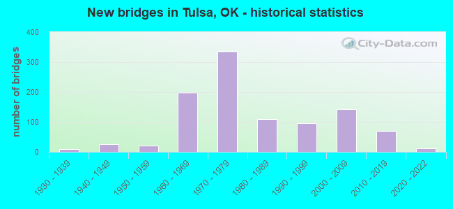
- New bridges - historical statistics
- 11910-1919
- 11920-1929
- 91930-1939
- 261940-1949
- 221950-1959
- 1971960-1969
- 3341970-1979
- 1101980-1989
- 961990-1999
- 1422000-2009
- 692010-2019
- 112020-2022
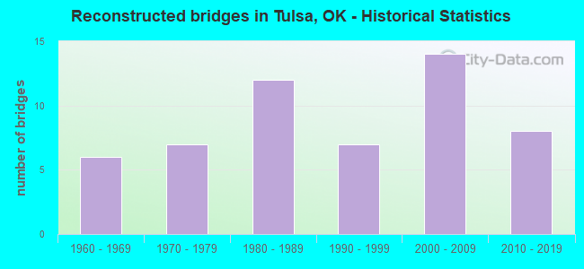
- Reconstructed bridges - Historical Statistics
- 61960-1969
- 71970-1979
- 121980-1989
- 71990-1999
- 142000-2009
- 82010-2019
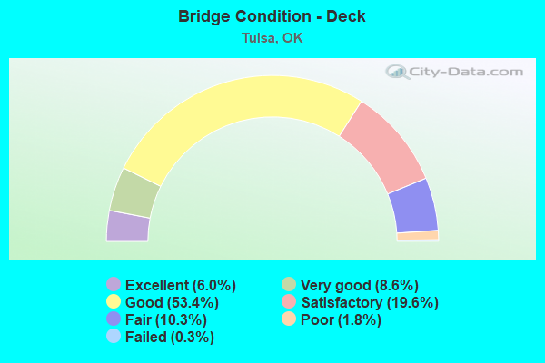
- Bridge Condition - Deck
- 6.0%Excellent
- 8.6%Very good
- 53.4%Good
- 19.6%Satisfactory
- 10.3%Fair
- 1.8%Poor
- 0.3%Failed
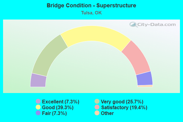
- Bridge Condition - Superstructure
- 7.3%Excellent
- 25.7%Very good
- 39.3%Good
- 19.4%Satisfactory
- 7.3%Fair
- 1.0%Poor
- 0.3%Critical
- 0.3%Failed
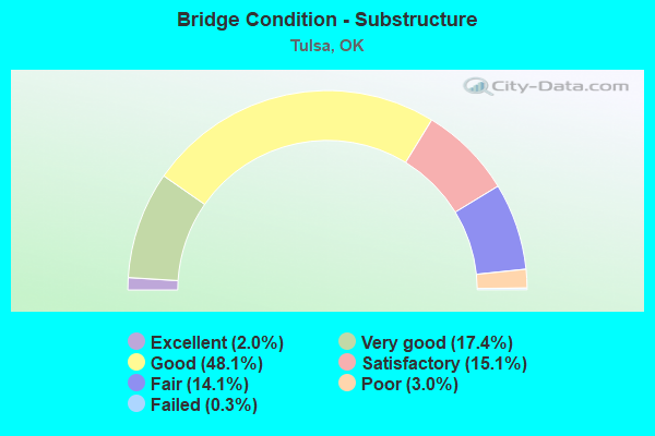
- Bridge Condition - Substructure
- 2.0%Excellent
- 17.4%Very good
- 48.1%Good
- 15.1%Satisfactory
- 14.1%Fair
- 3.0%Poor
- 0.3%Failed
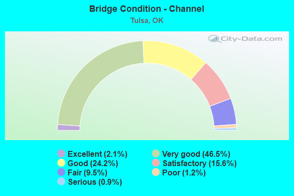
- Bridge Condition - Channel
- 2.1%Excellent
- 46.5%Very good
- 24.2%Good
- 15.6%Satisfactory
- 9.5%Fair
- 1.2%Poor
- 0.9%Serious
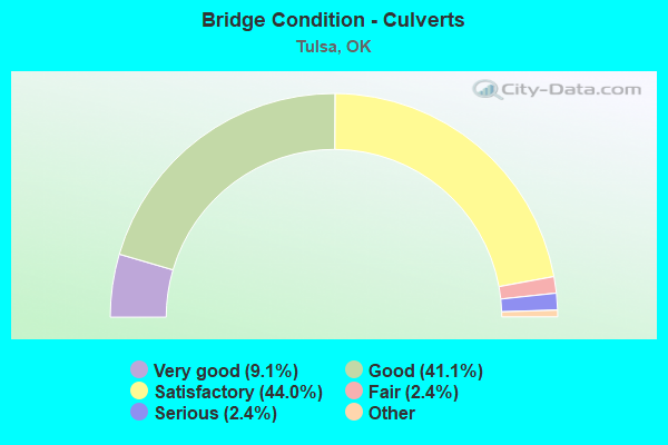
- Bridge Condition - Culverts
- 9.1%Excellent
- 41.1%Very good
- 44.0%Good
- 2.4%Satisfactory
- 2.4%Fair
- 1.0%Poor
- 2.4%Serious
Find on map >> Show street view
Structure Number: 16567, Location: 0.7 MI SE 21 ST (Lat: 36.125939, Lng: -95.940569), Route carried "under" structure: City street , Year Built: 1965, Structure Length: 0. m, Average Daily Traffic: 800 (year 2020), Truck Traffic: 5%, Features Intersected: HARVARD AVE UNDER, Facility Carried by Structure: U.S. 64 / S.H. 51
Minimum Vertical Clearance: 4.57m (14.99ft), Kilometerpoint: 4.665, Lanes on structure: 3, Lanes under structure: 5, Material/Design: Steel, Design/Construction: Stringer/Multi-beam, Length of Maximum Span: 16.5m (54.1ft)
Find on map >> Show street view
Structure Number: 16623, Location: 1.9 MI SE 21 ST (Lat: 36.119019, Lng: -95.921158), Route carried "under" structure: City street , Year Built: 1965, Structure Length: 0. m, Average Daily Traffic: 600 (year 2020), Truck Traffic: 5%, Features Intersected: 31ST ST. UNDER, Facility Carried by Structure: U.S. 64 /S.H.51WB
Minimum Vertical Clearance: 4.17m (13.68ft), Kilometerpoint: 6.597, Lanes on structure: 3, Lanes under structure: 4, Material/Design: Steel, Design/Construction: Stringer/Multi-beam, Length of Maximum Span: 27.3m (89.6ft)
Find on map >> Show street view
Structure Number: 16636, Location: 1.8 MI SE 21 ST (Lat: 36.119228, Lng: -95.922675), Route carried "under" structure: City street , Year Built: 1965, Structure Length: 0. m, Average Daily Traffic: 600 (year 2020), Truck Traffic: 5%, Features Intersected: YALE AVE & 31ST ST UNDER, Facility Carried by Structure: U.S. 64 /S.H.51 EB
Minimum Vertical Clearance: 4.27m (14.01ft), Kilometerpoint: 6.436, Lanes on structure: 3, Lanes under structure: 5, Material/Design: Steel, Design/Construction: Stringer/Multi-beam, Length of Maximum Span: 27.3m (89.6ft)
Find on map >> Show street view
Structure Number: 16636, Location: 1.8 MI SE 21 ST (Lat: 36.119228, Lng: -95.922675), Route carried "under" structure: City street , Year Built: 1965, Structure Length: 0. m, Average Daily Traffic: 600 (year 2020), Truck Traffic: 5%, Features Intersected: YALE AVE & 31ST ST UNDER, Facility Carried by Structure: U.S. 64 /S.H.51 EB
Minimum Vertical Clearance: 4.14m (13.58ft), Kilometerpoint: 6.436, Lanes on structure: 3, Lanes under structure: 4, Material/Design: Steel, Design/Construction: Stringer/Multi-beam, Length of Maximum Span: 27.3m (89.6ft)
Find on map >> Show street view
Structure Number: 16729, Location: 6.63 MI E JCT I 444 (Lat: 36.166172, Lng: -95.862233), Route carried "under" structure: Ramp Interstate 169, Year Built: 1966, Structure Length: 0. m, Average Daily Traffic: 40,000 (year 2020), Truck Traffic: 12%, Features Intersected: I-244 RAMP E-S UNDER
Minimum Vertical Clearance: 5.36m (17.59ft), Kilometerpoint: 21.931, Lanes on structure: 2, Lanes under structure: 1, Material/Design: Concrete continuous, Design/Construction: Slab, Length of Maximum Span: 11.3m (37.1ft)
Find on map >> Show street view
Structure Number: 16738, Location: .10 MI E JCT US 169 (Lat: 36.165833, Lng: -95.858889), Route carried "under" structure: Interstate 244, Year Built: 1966, Structure Length: 0. m, Average Daily Traffic: 83,600 (year 2020), Truck Traffic: 12%, Features Intersected: I-244 WB UNDER
Minimum Vertical Clearance: 5.33m (17.49ft), Kilometerpoint: 22.268, Lanes on structure: 1, Lanes under structure: 2, Material/Design: Concrete continuous, Design/Construction: Slab, Length of Maximum Span: 14.0m (45.9ft)
Find on map >> Show street view
Structure Number: 16775, Location: JCT N 69 E AVE (Lat: 36.187222, Lng: -95.900278), Route carried "under" structure: State highway 11, Year Built: 1966, Structure Length: 0. m, Average Daily Traffic: 38,300 (year 2020), Truck Traffic: 8%, Features Intersected: S.H. 11 UNDER, Facility Carried by Structure: N 69TH E. AVE.
Minimum Vertical Clearance: 4.60m (15.09ft), Kilometerpoint: 5.341, Lanes on structure: 2, Lanes under structure: 5, Material/Design: Steel, Design/Construction: Stringer/Multi-beam, Length of Maximum Span: 21.0m (68.9ft)
Find on map >> Show street view
Structure Number: 16776, Location: 0.9 MI SE SHERIDAN RD (Lat: 36.185761, Lng: -95.891569), Route carried "under" structure: City street , Year Built: 1966, Structure Length: 0. m, Average Daily Traffic: 4,000 (year 2020), Truck Traffic: 10%, Features Intersected: AIRPORT RD. UNDER, Facility Carried by Structure: S.H. 11 WB
Minimum Vertical Clearance: 5.31m (17.42ft), Kilometerpoint: 6.291, Lanes on structure: 2, Lanes under structure: 4, Material/Design: Concrete continuous, Design/Construction: Slab, Length of Maximum Span: 13.1m (43.0ft)
Find on map >> Show street view
Structure Number: 16777, Location: 0.9 MI SE SHERIDAN RD (Lat: 36.185517, Lng: -95.891803), Route carried "under" structure: City street , Year Built: 1966, Structure Length: 0. m, Average Daily Traffic: 4,000 (year 2020), Truck Traffic: 5%, Features Intersected: AIRPORT RD. UNDER, Facility Carried by Structure: S.H. 11 EB
Minimum Vertical Clearance: 5.16m (16.93ft), Kilometerpoint: 6.291, Lanes on structure: 2, Lanes under structure: 4, Material/Design: Concrete continuous, Design/Construction: Slab, Length of Maximum Span: 13.1m (43.0ft)
Find on map >> Show street view
Structure Number: 16778, Location: 6.69 MI E JCT I 244 (Lat: 36.164594, Lng: -95.861339), Route carried "under" structure: US 169, Year Built: 1966, Structure Length: 0. m, Average Daily Traffic: 116,300 (year 2020), Truck Traffic: 8%, Features Intersected: U.S. 169 UNDER, Facility Carried by Structure: I-244
Minimum Vertical Clearance: 4.85m (15.91ft), Kilometerpoint: 2.750, Lanes on structure: 4, Lanes under structure: 6, Material/Design: Steel continuous, Design/Construction: Stringer/Multi-beam, Length of Maximum Span: 19.5m (64.0ft)
Find on map >> Show street view
Structure Number: 16779, Location: 6.69 MI E JCT I 444 (Lat: 36.165717, Lng: -95.861336), Route carried "under" structure: US 169, Year Built: 1966, Structure Length: 0. m, Average Daily Traffic: 116,300 (year 2020), Truck Traffic: 8%, Features Intersected: U.S. 169 UNDER, Facility Carried by Structure: I-244
Minimum Vertical Clearance: 4.88m (16.01ft), Kilometerpoint: 2.865, Lanes on structure: 3, Lanes under structure: 6, Material/Design: Steel continuous, Design/Construction: Stringer/Multi-beam, Length of Maximum Span: 19.8m (65.0ft)
Find on map >> Show street view
Structure Number: 16787, Location: JCT SHERIDAN RD (Lat: 36.188714, Lng: -95.904717), Route carried "under" structure: State highway 11, Year Built: 1966, Structure Length: 0. m, Average Daily Traffic: 38,300 (year 2020), Truck Traffic: 8%, Features Intersected: S.H. 11 UNDER, Facility Carried by Structure: SHERIDAN RD. SB
Minimum Vertical Clearance: 4.93m (16.17ft), Kilometerpoint: 4.843, Lanes on structure: 2, Lanes under structure: 4, Material/Design: Steel, Design/Construction: Stringer/Multi-beam, Length of Maximum Span: 20.4m (66.9ft)
Find on map >> Show street view
Structure Number: 16788, Location: JCT SHERIDAN RD (Lat: 36.188611, Lng: -95.904444), Route carried "under" structure: State highway 11, Year Built: 1966, Structure Length: 0. m, Average Daily Traffic: 38,300 (year 2020), Truck Traffic: 8%, Features Intersected: S.H. 11 UNDER, Facility Carried by Structure: SHERIDAN RD. NB
Minimum Vertical Clearance: 4.85m (15.91ft), Kilometerpoint: 4.875, Lanes on structure: 2, Lanes under structure: 4, Material/Design: Steel, Design/Construction: Stringer/Multi-beam, Length of Maximum Span: 20.4m (66.9ft)
Find on map >> Show street view
Structure Number: 16789, Location: .53 MI E JCT US 169 (Lat: 36.165994, Lng: -95.851250), Route carried "under" structure: Interstate 244, Year Built: 1966, Structure Length: 0. m, Average Daily Traffic: 32,200 (year 2020), Truck Traffic: 12%, Features Intersected: I-244 UNDER, Facility Carried by Structure: GARNETT RD.
Minimum Vertical Clearance: 5.00m (16.40ft), Kilometerpoint: 36.951, Lanes on structure: 4, Lanes under structure: 6, Material/Design: Steel continuous, Design/Construction: Stringer/Multi-beam, Length of Maximum Span: 22.3m (73.2ft)
Find on map >> Show street view
Structure Number: 16818, Location: .01 MI E JCT US 169 (Lat: 36.164678, Lng: -95.860094), Route carried "under" structure: Interstate 169, Year Built: 1966, Structure Length: 0. m, Average Daily Traffic: 58,150 (year 2020), Truck Traffic: 12%, Features Intersected: I-244 UNDER
Minimum Vertical Clearance: 4.85m (15.91ft), Kilometerpoint: 2.750, Lanes on structure: 2, Lanes under structure: 3, Material/Design: Steel, Design/Construction: Stringer/Multi-beam, Length of Maximum Span: 25.0m (82.0ft)
Find on map >> Show street view
Structure Number: 16818, Location: .01 MI E JCT US 169 (Lat: 36.164678, Lng: -95.860094), Route carried "under" structure: Interstate 244, Year Built: 1966, Structure Length: 0. m, Average Daily Traffic: 83,600 (year 2020), Truck Traffic: 12%, Features Intersected: I-244 UNDER, Facility Carried by Structure: U.S. 169 RAMP S-W
Minimum Vertical Clearance: 4.90m (16.08ft), Kilometerpoint: 22.124, Lanes on structure: 2, Lanes under structure: 7, Material/Design: Steel, Design/Construction: Stringer/Multi-beam, Length of Maximum Span: 25.0m (82.0ft)
Find on map >> Show street view
Structure Number: 16818, Location: .01 MI E JCT US 169 (Lat: 36.164678, Lng: -95.860094), Route carried "under" structure: Interstate 244, Year Built: 1966, Structure Length: 0. m, Average Daily Traffic: 41,800 (year 2020), Truck Traffic: 12%, Features Intersected: I-244 UNDER, Facility Carried by Structure: U.S. 169 RAMP S-W
Minimum Vertical Clearance: 5.16m (16.93ft), Kilometerpoint: 22.124, Lanes on structure: 2, Lanes under structure: 3, Material/Design: Steel, Design/Construction: Stringer/Multi-beam, Length of Maximum Span: 25.0m (82.0ft)
Find on map >> Show street view
Structure Number: 16818, Location: .01 MI E JCT US 169 (Lat: 36.164678, Lng: -95.860094), Route carried "under" structure: US 169, Year Built: 1966, Structure Length: 0. m, Average Daily Traffic: 116,300 (year 2020), Truck Traffic: 12%, Features Intersected: I-244 UNDER
Minimum Vertical Clearance: 4.95m (16.24ft), Kilometerpoint: 2.750, Lanes on structure: 2, Lanes under structure: 6, Material/Design: Steel, Design/Construction: Stringer/Multi-beam, Length of Maximum Span: 25.0m (82.0ft)
Find on map >> Show street view
Structure Number: 16926, Location: 4.24 MI E JCT I 444 (Lat: 36.162778, Lng: -95.904722), Route carried "under" structure: Interstate 244, Year Built: 1967, Structure Length: 0. m, Average Daily Traffic: 35,300 (year 2020), Truck Traffic: 12%, Features Intersected: I-244 EB UNDER, Facility Carried by Structure: SHERIDAN RD.
Minimum Vertical Clearance: 4.93m (16.17ft), Kilometerpoint: 18.084, Lanes on structure: 5, Lanes under structure: 4, Material/Design: Steel, Design/Construction: Stringer/Multi-beam, Length of Maximum Span: 21.9m (71.9ft)
Find on map >> Show street view
Structure Number: 16927, Location: 4.24 MI E JCT I 444 (Lat: 36.163333, Lng: -95.904722), Route carried "under" structure: Interstate 244, Year Built: 1967, Structure Length: 0. m, Average Daily Traffic: 35,800 (year 2020), Truck Traffic: 12%, Features Intersected: I-244 WB UNDER, Facility Carried by Structure: SHERIDAN RD.
Minimum Vertical Clearance: 5.00m (16.40ft), Kilometerpoint: 18.084, Lanes on structure: 5, Lanes under structure: 4, Material/Design: Steel, Design/Construction: Stringer/Multi-beam, Length of Maximum Span: 21.9m (71.9ft)
Find on map >> Show street view
Structure Number: 16961, Location: 4.74 MI E JCT I 444 (Lat: 36.161822, Lng: -95.895844), Route carried "under" structure: City street , Year Built: 1967, Structure Length: 0. m, Average Daily Traffic: 1,000 (year 2020), Truck Traffic: 10%, Features Intersected: 73RD E AVE. UNDER, Facility Carried by Structure: I-244
Minimum Vertical Clearance: 4.32m (14.17ft), Kilometerpoint: 18.890, Lanes on structure: 8, Lanes under structure: 2, Material/Design: Steel, Design/Construction: Stringer/Multi-beam, Length of Maximum Span: 18.9m (62.0ft)
Find on map >> Show street view
Structure Number: 16962, Location: 5.74 MI E JCT I 444 (Lat: 36.162947, Lng: -95.877978), Route carried "under" structure: City street , Year Built: 1967, Structure Length: 0. m, Average Daily Traffic: 1,000 (year 2020), Truck Traffic: 5%, Features Intersected: 89TH E AVENUE UNDER, Facility Carried by Structure: I-244 WB
Minimum Vertical Clearance: 4.32m (14.17ft), Kilometerpoint: 20.498, Lanes on structure: 4, Lanes under structure: 2, Material/Design: Steel, Design/Construction: Stringer/Multi-beam, Length of Maximum Span: 19.2m (63.0ft)
Find on map >> Show street view
Structure Number: 16963, Location: 5.74 MI E JCT I 444 (Lat: 36.162369, Lng: -95.877964), Route carried "under" structure: City street , Year Built: 1967, Structure Length: 0. m, Average Daily Traffic: 1,000 (year 2020), Truck Traffic: 10%, Features Intersected: 89TH E AVENUE UNDER, Facility Carried by Structure: I-244 EB
Minimum Vertical Clearance: 4.55m (14.93ft), Kilometerpoint: 20.498, Lanes on structure: 4, Lanes under structure: 2, Material/Design: Steel, Design/Construction: Stringer/Multi-beam, Length of Maximum Span: 20.1m (65.9ft)
Find on map >> Show street view
Structure Number: 16967, Location: 5.39 MI E JCT I 444 (Lat: 36.162222, Lng: -95.884444), Route carried "under" structure: Ramp Interstate 244, Year Built: 1967, Structure Length: 0. m, Average Daily Traffic: 72,000 (year 2020), Truck Traffic: 12%, Features Intersected: I-244 RAMP W-N UNDER
Minimum Vertical Clearance: 5.15m (16.90ft), Kilometerpoint: 19.937, Lanes on structure: 1, Lanes under structure: 1, Material/Design: Steel, Design/Construction: Stringer/Multi-beam, Length of Maximum Span: 20.1m (65.9ft)
Find on map >> Show street view
Structure Number: 16969, Location: 5.51 MI E JCT I 444 (Lat: 36.162778, Lng: -95.882222), Route carried "under" structure: Interstate 244, Year Built: 1967, Structure Length: 0. m, Average Daily Traffic: 35,500 (year 2020), Truck Traffic: 12%, Features Intersected: I-244 / US 412 WB UNDER
Minimum Vertical Clearance: 5.41m (17.75ft), Kilometerpoint: 32.394, Lanes on structure: 1, Lanes under structure: 3, Material/Design: Steel continuous, Design/Construction: Stringer/Multi-beam, Length of Maximum Span: 19.2m (63.0ft)
Find on map >> Show street view
Structure Number: 16974, Location: 1.66 MI E JCT I-444 (Lat: 36.160094, Lng: -95.949478), Route carried "under" structure: City street , Year Built: 1967, Structure Length: 0. m, Average Daily Traffic: 5,000 (year 2020), Truck Traffic: 5%, Features Intersected: DELAWARE AVE. UNDER, Facility Carried by Structure: I-244
Minimum Vertical Clearance: 4.60m (15.09ft), Kilometerpoint: 13.918, Lanes on structure: 8, Lanes under structure: 4, Material/Design: Steel continuous, Design/Construction: Stringer/Multi-beam, Length of Maximum Span: 23.5m (77.1ft)
Find on map >> Show street view
Structure Number: 16975, Location: 6.26 MI E JCT I 444 (Lat: 36.164661, Lng: -95.868967), Route carried "under" structure: City street , Year Built: 1967, Structure Length: 0. m, Average Daily Traffic: 1,000 (year 2020), Truck Traffic: 5%, Features Intersected: MINGO ROAD UNDER, Facility Carried by Structure: I-244 WB
Minimum Vertical Clearance: 5.38m (17.65ft), Kilometerpoint: 21.335, Lanes on structure: 4, Lanes under structure: 5, Material/Design: Steel continuous, Design/Construction: Stringer/Multi-beam, Length of Maximum Span: 15.8m (51.8ft)
Find on map >> Show street view
Structure Number: 16976, Location: 6.26 MI E JCT I 444 (Lat: 36.164075, Lng: -95.868964), Route carried "under" structure: City street , Year Built: 1967, Structure Length: 0. m, Average Daily Traffic: 1,000 (year 2020), Truck Traffic: 15%, Features Intersected: MINGO ROAD UNDER, Facility Carried by Structure: I-244 EB
Minimum Vertical Clearance: 4.75m (15.58ft), Kilometerpoint: 21.335, Lanes on structure: 4, Lanes under structure: 5, Material/Design: Steel continuous, Design/Construction: Stringer/Multi-beam, Length of Maximum Span: 15.5m (50.9ft)
Find on map >> Show street view
Structure Number: 16977, Location: 5.45 MI E JCT I 444 (Lat: 36.163056, Lng: -95.883333), Route carried "under" structure: Interstate 244, Year Built: 1967, Structure Length: 0. m, Average Daily Traffic: 35,500 (year 2020), Truck Traffic: 12%, Features Intersected: I-244 WB UNDER
Minimum Vertical Clearance: 5.08m (16.67ft), Kilometerpoint: 20.032, Lanes on structure: 1, Lanes under structure: 4, Material/Design: Steel, Design/Construction: Stringer/Multi-beam, Length of Maximum Span: 25.0m (82.0ft)
Find on map >> Show street view
Structure Number: 16983, Location: 5.25 MI E JCT I 444 (Lat: 36.162778, Lng: -95.886667), Route carried "under" structure: Interstate 244, Year Built: 1967, Structure Length: 0. m, Average Daily Traffic: 35,800 (year 2020), Truck Traffic: 12%, Features Intersected: I-244 WB UNDER, Facility Carried by Structure: MEMORIAL RD.
Minimum Vertical Clearance: 7.09m (23.26ft), Kilometerpoint: 19.710, Lanes on structure: 5, Lanes under structure: 4, Material/Design: Steel, Design/Construction: Stringer/Multi-beam, Length of Maximum Span: 25.6m (84.0ft)
Find on map >> Show street view
Structure Number: 16984, Location: 5.25 MI E JCT I 444 (Lat: 36.161667, Lng: -95.886667), Route carried "under" structure: Interstate 244, Year Built: 1967, Structure Length: 0. m, Average Daily Traffic: 35,300 (year 2020), Truck Traffic: 12%, Features Intersected: I-244 EB UNDER, Facility Carried by Structure: MEMORIAL RD.
Minimum Vertical Clearance: 7.59m (24.90ft), Kilometerpoint: 19.710, Lanes on structure: 4, Lanes under structure: 4, Material/Design: Steel continuous, Design/Construction: Stringer/Multi-beam, Length of Maximum Span: 21.9m (71.9ft)
Find on map >> Show street view
Structure Number: 16986, Location: 5.48 MI E JCT I 444 (Lat: 36.164069, Lng: -95.882694), Route carried "under" structure: Ramp Interstate 244, Year Built: 1967, Structure Length: 0. m, Average Daily Traffic: 36,000 (year 2020), Truck Traffic: 12%, Features Intersected: S.H. 11 N-E RAMP UNDER
Minimum Vertical Clearance: 4.90m (16.08ft), Kilometerpoint: 20.080, Lanes on structure: 1, Lanes under structure: 1, Material/Design: Steel, Design/Construction: Stringer/Multi-beam, Length of Maximum Span: 24.1m (79.1ft)
Find on map >> Show street view
Structure Number: 1699, Location: 9.1 MI N & E OF I-44 (Lat: 36.159444, Lng: -95.940278), Route carried "under" structure: Interstate 244, Year Built: 1967, Structure Length: 0. m, Average Daily Traffic: 62,600 (year 2020), Truck Traffic: 12%, Features Intersected: I-244 UNDER, Facility Carried by Structure: HARVARD AVE.
Minimum Vertical Clearance: 5.08m (16.67ft), Kilometerpoint: 14.754, Lanes on structure: 5, Lanes under structure: 8, Material/Design: Steel continuous, Design/Construction: Stringer/Multi-beam, Length of Maximum Span: 27.7m (90.9ft)
Find on map >> Show street view
Structure Number: 16991, Location: 2.67 MI E JCT I 444 (Lat: 36.159167, Lng: -95.931389), Route carried "under" structure: Interstate 244, Year Built: 1967, Structure Length: 0. m, Average Daily Traffic: 62,600 (year 2020), Truck Traffic: 12%, Features Intersected: I-244 UNDER, Facility Carried by Structure: PITTSBURG AVE.
Minimum Vertical Clearance: 4.90m (16.08ft), Kilometerpoint: 15.559, Lanes on structure: 5, Lanes under structure: 8, Material/Design: Steel continuous, Design/Construction: Stringer/Multi-beam, Length of Maximum Span: 27.7m (90.9ft)
Find on map >> Show street view
Structure Number: 16992, Location: 10.1 MI N & E I-44 (Lat: 36.158889, Lng: -95.922500), Route carried "under" structure: Interstate 244, Year Built: 1967, Structure Length: 0. m, Average Daily Traffic: 62,600 (year 2020), Truck Traffic: 12%, Features Intersected: I-244 UNDER, Facility Carried by Structure: YALE AVE.
Minimum Vertical Clearance: 5.03m (16.50ft), Kilometerpoint: 16.364, Lanes on structure: 6, Lanes under structure: 8, Material/Design: Steel continuous, Design/Construction: Stringer/Multi-beam, Length of Maximum Span: 27.7m (90.9ft)
Find on map >> Show street view
Structure Number: 16998, Location: 5.54 MI E JCT I 444 (Lat: 36.161842, Lng: -95.881472), Route carried "under" structure: Interstate 244, Year Built: 1967, Structure Length: 0. m, Average Daily Traffic: 35,500 (year 2020), Truck Traffic: 12%, Features Intersected: I-244 EB & MEMORIAL RAMP
Minimum Vertical Clearance: 5.08m (16.67ft), Kilometerpoint: 20.176, Lanes on structure: 1, Lanes under structure: 3, Material/Design: Steel, Design/Construction: Stringer/Multi-beam, Length of Maximum Span: 29.8m (97.8ft)
Find on map >> Show street view
Structure Number: 16998, Location: 5.54 MI E JCT I 444 (Lat: 36.161842, Lng: -95.881472), Route carried "under" structure: Ramp State highway , Year Built: 1967, Structure Length: 0. m, Average Daily Traffic: 1,000 (year 2020), Truck Traffic: 12%, Features Intersected: I-244 EB & MEMORIAL RAMP, Facility Carried by Structure: S.H11 EB TO I244EB
Minimum Vertical Clearance: 5.54m (18.18ft), Kilometerpoint: 20.176, Lanes on structure: 1, Lanes under structure: 1, Material/Design: Steel, Design/Construction: Stringer/Multi-beam, Length of Maximum Span: 29.8m (97.8ft)
Find on map >> Show street view
Structure Number: 17022, Location: 2.4 MI E US 169 (Lat: 36.161389, Lng: -95.826389), Route carried "under" structure: Interstate 44, Year Built: 1967, Structure Length: 0. m, Average Daily Traffic: 46,000 (year 2020), Truck Traffic: 12%, Features Intersected: I-44 UNDER
Minimum Vertical Clearance: 5.03m (16.50ft), Kilometerpoint: 22.252, Lanes on structure: 2, Lanes under structure: 6, Material/Design: Steel, Design/Construction: Stringer/Multi-beam, Length of Maximum Span: 37.5m (123.0ft)
Find on map >> Show street view
Structure Number: 17041, Location: 3.62 MI E JCT I 444 (Lat: 36.160175, Lng: -95.914875), Route carried "under" structure: City street , Year Built: 1967, Structure Length: 0. m, Average Daily Traffic: 900 (year 2020), Truck Traffic: 5%, Features Intersected: ADMIRAL PL. UNDER, Facility Carried by Structure: I-244
Minimum Vertical Clearance: 7.04m (23.10ft), Kilometerpoint: 17.088, Lanes on structure: 8, Lanes under structure: 2, Material/Design: Steel continuous, Design/Construction: Stringer/Multi-beam, Length of Maximum Span: 20.7m (67.9ft)
Find on map >> Show street view
Structure Number: 17041, Location: 3.62 MI E JCT I 444 (Lat: 36.160175, Lng: -95.914875), Route carried "under" structure: City street , Year Built: 1967, Structure Length: 0. m, Average Daily Traffic: 5,000 (year 2020), Truck Traffic: 5%, Features Intersected: ADMIRAL PL. UNDER, Facility Carried by Structure: I-244
Minimum Vertical Clearance: 5.23m (17.16ft), Kilometerpoint: 17.088, Lanes on structure: 8, Lanes under structure: 4, Material/Design: Steel continuous, Design/Construction: Stringer/Multi-beam, Length of Maximum Span: 20.7m (67.9ft)
Find on map >> Show street view
Structure Number: 1724, Location: 1.17 MI E JCT I-444 (Lat: 36.160556, Lng: -95.958056), Route carried "under" structure: Interstate 244, Year Built: 1968, Structure Length: 0. m, Average Daily Traffic: 62,600 (year 2020), Truck Traffic: 12%, Features Intersected: I-244 UNDER, Facility Carried by Structure: LEWIS AVE.
Minimum Vertical Clearance: 4.95m (16.24ft), Kilometerpoint: 13.147, Lanes on structure: 4, Lanes under structure: 8, Material/Design: Steel continuous, Design/Construction: Stringer/Multi-beam, Length of Maximum Span: 22.6m (74.1ft)
Find on map >> Show street view
Structure Number: 17253, Location: 1.7 MI SE SHERIDAN RD (Lat: 36.177258, Lng: -95.885167), Route carried "under" structure: City street , Year Built: 1968, Structure Length: 0. m, Average Daily Traffic: 1,000 (year 2020), Truck Traffic: 10%, Features Intersected: PINE ST UNDER, Facility Carried by Structure: S.H. 11 EB
Minimum Vertical Clearance: 4.77m (15.65ft), Kilometerpoint: 7.546, Lanes on structure: 2, Lanes under structure: 5, Material/Design: Steel, Design/Construction: Stringer/Multi-beam, Length of Maximum Span: 25.4m (83.3ft)
Find on map >> Show street view
Structure Number: 17262, Location: 1.7 MI SE SHERIDAN RD (Lat: 36.177258, Lng: -95.884794), Route carried "under" structure: City street , Year Built: 1968, Structure Length: 0. m, Average Daily Traffic: 1,000 (year 2020), Truck Traffic: 5%, Features Intersected: PINE ST UNDER, Facility Carried by Structure: S.H. 11 WB
Minimum Vertical Clearance: 5.28m (17.32ft), Kilometerpoint: 7.546, Lanes on structure: 2, Lanes under structure: 5, Material/Design: Steel, Design/Construction: Stringer/Multi-beam, Length of Maximum Span: 24.9m (81.7ft)
Find on map >> Show street view
Structure Number: 17283, Location: 1.0 MI E PEORIA AVE (Lat: 36.143017, Lng: -95.958494), Route carried "under" structure: City street , Year Built: 1968, Structure Length: 0. m, Average Daily Traffic: 3,000 (year 2020), Truck Traffic: 5%, Features Intersected: LEWIS AVE UNDER, Facility Carried by Structure: U.S. 64 WB
Minimum Vertical Clearance: 4.88m (16.01ft), Kilometerpoint: 2.253, Lanes on structure: 3, Lanes under structure: 6, Material/Design: Steel, Design/Construction: Stringer/Multi-beam, Length of Maximum Span: 15.0m (49.2ft)
Find on map >> Show street view
Structure Number: 17284, Location: 1.0 MI E PEORIA AVE (Lat: 36.142622, Lng: -95.958494), Route carried "under" structure: City street , Year Built: 1968, Structure Length: 0. m, Average Daily Traffic: 1,000 (year 2020), Truck Traffic: 5%, Features Intersected: LEWIS AVE UNDER, Facility Carried by Structure: U.S. 64 EB
Minimum Vertical Clearance: 4.65m (15.26ft), Kilometerpoint: 2.253, Lanes on structure: 3, Lanes under structure: 6, Material/Design: Steel, Design/Construction: Stringer/Multi-beam, Length of Maximum Span: 15.2m (49.9ft)
Find on map >> Show street view
Structure Number: 17285, Location: 1.2 MI E PEORIA AVE (Lat: 36.140764, Lng: -95.954103), Route carried "under" structure: City street , Year Built: 1968, Structure Length: 0. m, Average Daily Traffic: 1,000 (year 2020), Truck Traffic: 5%, Features Intersected: 15 ST. UNDER, Facility Carried by Structure: U.S. 64 WB
Minimum Vertical Clearance: 4.85m (15.91ft), Kilometerpoint: 2.573, Lanes on structure: 3, Lanes under structure: 4, Material/Design: Steel, Design/Construction: Stringer/Multi-beam, Length of Maximum Span: 13.7m (44.9ft)
Find on map >> Show street view
Structure Number: 17302, Location: 1.2 MI E PEORIA AVE (Lat: 36.140744, Lng: -95.954881), Route carried "under" structure: City street , Year Built: 1968, Structure Length: 0. m, Average Daily Traffic: 1,000 (year 2020), Truck Traffic: 5%, Features Intersected: 15 ST. UNDER, Facility Carried by Structure: U.S. 64 EB
Minimum Vertical Clearance: 4.72m (15.49ft), Kilometerpoint: 2.573, Lanes on structure: 4, Lanes under structure: 4, Material/Design: Steel, Design/Construction: Stringer/Multi-beam, Length of Maximum Span: 14.0m (45.9ft)
Find on map >> Show street view
Structure Number: 17303, Location: 1.8 MI E PEORIA AVE (Lat: 36.133478, Lng: -95.948836), Route carried "under" structure: City street , Year Built: 1968, Structure Length: 0. m, Average Daily Traffic: 700 (year 2020), Truck Traffic: 5%, Features Intersected: 21ST ST. UNDER, Facility Carried by Structure: U.S. 64 / S.H. 51
Minimum Vertical Clearance: 4.60m (15.09ft), Kilometerpoint: 3.541, Lanes on structure: 3, Lanes under structure: 4, Material/Design: Steel, Design/Construction: Stringer/Multi-beam, Length of Maximum Span: 14.0m (45.9ft)
Find on map >> Show street view
Structure Number: 17304, Location: 1.8 MI E PEORIA AVE (Lat: 36.133475, Lng: -95.949356), Route carried "under" structure: City street , Year Built: 1968, Structure Length: 0. m, Average Daily Traffic: 700 (year 2020), Truck Traffic: 5%, Features Intersected: 21ST ST. UNDER, Facility Carried by Structure: U.S. 64 / S.H. 51
Minimum Vertical Clearance: 4.60m (15.09ft), Kilometerpoint: 3.541, Lanes on structure: 3, Lanes under structure: 4, Material/Design: Steel, Design/Construction: Stringer/Multi-beam, Length of Maximum Span: 14.0m (45.9ft)
Find on map >> Show street view
Structure Number: 1731, Location: .65 MI E JCT I 444 (Lat: 36.158889, Lng: -95.967222), Route carried "under" structure: Interstate 244, Year Built: 1968, Structure Length: 0. m, Average Daily Traffic: 62,600 (year 2020), Truck Traffic: 12%, Features Intersected: I-244 UNDER, Facility Carried by Structure: UTICA AVE.
Minimum Vertical Clearance: 5.00m (16.40ft), Kilometerpoint: 12.308, Lanes on structure: 6, Lanes under structure: 8, Material/Design: Steel continuous, Design/Construction: Stringer/Multi-beam, Length of Maximum Span: 27.4m (89.9ft)
Find on map >> Show street view
Structure Number: 17342, Location: 1.4 MI SE SHERIDAN RD (Lat: 36.180456, Lng: -95.886994), Route carried "under" structure: City street , Year Built: 1968, Structure Length: 0. m, Average Daily Traffic: 800 (year 2020), Truck Traffic: 5%, Features Intersected: MEMORIAL RD. UNDER, Facility Carried by Structure: S.H. 11 WB
Minimum Vertical Clearance: 5.46m (17.91ft), Kilometerpoint: 7.144, Lanes on structure: 3, Lanes under structure: 4, Material/Design: Steel continuous, Design/Construction: Stringer/Multi-beam, Length of Maximum Span: 20.4m (66.9ft)
Find on map >> Show street view
Structure Number: 17343, Location: 1.4 MI SE SHERIDAN RD (Lat: 36.179933, Lng: -95.886994), Route carried "under" structure: City street , Year Built: 1968, Structure Length: 0. m, Average Daily Traffic: 800 (year 2020), Truck Traffic: 5%, Features Intersected: MEMORIAL RD. UNDER, Facility Carried by Structure: S.H. 11 EB
Minimum Vertical Clearance: 4.67m (15.32ft), Kilometerpoint: 7.144, Lanes on structure: 2, Lanes under structure: 4, Material/Design: Steel continuous, Design/Construction: Stringer/Multi-beam, Length of Maximum Span: 20.4m (66.9ft)
Find on map >> Show street view
Structure Number: 17607, Location: 4.8 MI N I-44 (Lat: 36.147819, Lng: -96.001983), Route carried "under" structure: City street , Year Built: 1969, Structure Length: 0. m, Average Daily Traffic: 800 (year 2020), Truck Traffic: 5%, Features Intersected: STREET & BNSF R.R. UNDER, Facility Carried by Structure: I-244 NB
Minimum Vertical Clearance: 5.64m (18.50ft), Kilometerpoint: 0.000, Lanes on structure: 3, Lanes under structure: 1, Material/Design: Steel continuous, Design/Construction: Stringer/Multi-beam, Length of Maximum Span: 27.4m (89.9ft)
Find on map >> Show street view
Structure Number: 17607, Location: 4.8 MI N I-44 (Lat: 36.147819, Lng: -96.001983), Route carried "under" structure: City street , Year Built: 1969, Structure Length: 0. m, Average Daily Traffic: 800 (year 2020), Truck Traffic: 5%, Features Intersected: STREET & BNSF R.R. UNDER, Facility Carried by Structure: I-244 NB
Minimum Vertical Clearance: 4.65m (15.26ft), Kilometerpoint: 7.868, Lanes on structure: 3, Lanes under structure: 4, Material/Design: Steel continuous, Design/Construction: Stringer/Multi-beam, Length of Maximum Span: 27.4m (89.9ft)
Find on map >> Show street view
Structure Number: 17607, Location: 4.8 MI N I-44 (Lat: 36.147819, Lng: -96.001983), Route carried "under" structure: City street , Year Built: 1969, Structure Length: 0. m, Average Daily Traffic: 800 (year 2020), Truck Traffic: 5%, Features Intersected: STREET & BNSF R.R. UNDER, Facility Carried by Structure: I-244 NB
Minimum Vertical Clearance: 5.18m (16.99ft), Kilometerpoint: 7.868, Lanes on structure: 3, Lanes under structure: 1, Material/Design: Steel continuous, Design/Construction: Stringer/Multi-beam, Length of Maximum Span: 27.4m (89.9ft)
Find on map >> Show street view
Structure Number: 17608, Location: 4.8 MI N I-44 (Lat: 36.147506, Lng: -96.002847), Route carried "under" structure: City street , Year Built: 1969, Structure Length: 0. m, Average Daily Traffic: 800 (year 2020), Truck Traffic: 5%, Features Intersected: STREET & BNSF R.R. UNDER, Facility Carried by Structure: I-244 SB
Minimum Vertical Clearance: 5.58m (18.31ft), Kilometerpoint: 7.836, Lanes on structure: 3, Lanes under structure: 1, Material/Design: Steel continuous, Design/Construction: Stringer/Multi-beam, Length of Maximum Span: 24.4m (80.1ft)
Find on map >> Show street view
Structure Number: 17608, Location: 4.8 MI N I-44 (Lat: 36.147506, Lng: -96.002847), Route carried "under" structure: City street , Year Built: 1969, Structure Length: 0. m, Average Daily Traffic: 800 (year 2020), Truck Traffic: 5%, Features Intersected: STREET & BNSF R.R. UNDER, Facility Carried by Structure: I-244 SB
Minimum Vertical Clearance: 4.66m (15.29ft), Kilometerpoint: 7.836, Lanes on structure: 3, Lanes under structure: 4, Material/Design: Steel continuous, Design/Construction: Stringer/Multi-beam, Length of Maximum Span: 24.4m (80.1ft)
Find on map >> Show street view
Structure Number: 17889, Location: .16 MI E JCT I 444 (Lat: 36.159486, Lng: -95.975847), Route carried "under" structure: City street , Year Built: 1970, Structure Length: 0. m, Average Daily Traffic: 1,000 (year 2020), Truck Traffic: 5%, Features Intersected: PEORIA AVE. UNDER, Facility Carried by Structure: I-244
Minimum Vertical Clearance: 4.90m (16.08ft), Kilometerpoint: 11.520, Lanes on structure: 6, Lanes under structure: 5, Material/Design: Steel continuous, Design/Construction: Stringer/Multi-beam, Length of Maximum Span: 25.6m (84.0ft)
Find on map >> Show street view
Structure Number: 1789, Location: .16 MI E JCT I 444 (Lat: 36.158936, Lng: -95.975847), Route carried "under" structure: City street , Year Built: 1970, Structure Length: 0. m, Average Daily Traffic: 1,000 (year 2020), Truck Traffic: 5%, Features Intersected: PEORIA AVE. UNDER, Facility Carried by Structure: I-244
Minimum Vertical Clearance: 4.65m (15.26ft), Kilometerpoint: 11.520, Lanes on structure: 4, Lanes under structure: 4, Material/Design: Steel continuous, Design/Construction: Stringer/Multi-beam, Length of Maximum Span: 25.6m (84.0ft)
Find on map >> Show street view
Structure Number: 1802, Location: 5.8 MI N I-44 (Lat: 36.160692, Lng: -95.997883), Route carried "under" structure: City street , Year Built: 1971, Structure Length: 0. m, Average Daily Traffic: 1,000 (year 2020), Truck Traffic: 5%, Features Intersected: CHEYENNE AVE. UNDER, Facility Carried by Structure: I-244
Minimum Vertical Clearance: 4.90m (16.08ft), Kilometerpoint: 9.445, Lanes on structure: 9, Lanes under structure: 2, Material/Design: Steel, Design/Construction: Stringer/Multi-beam, Length of Maximum Span: 23.5m (77.1ft)
Find on map >> Show street view
Structure Number: 18021, Location: 5.9 MI N I-44 (Lat: 36.160925, Lng: -95.996606), Route carried "under" structure: City street , Year Built: 1971, Structure Length: 0. m, Average Daily Traffic: 1,000 (year 2020), Truck Traffic: 5%, Features Intersected: BOULDER AVE UNDER, Facility Carried by Structure: I-244
Minimum Vertical Clearance: 4.39m (14.40ft), Kilometerpoint: 9.556, Lanes on structure: 8, Lanes under structure: 2, Material/Design: Steel, Design/Construction: Stringer/Multi-beam, Length of Maximum Span: 23.5m (77.1ft)
Find on map >> Show street view
Structure Number: 18022, Location: 6.0 MI N I-44 (Lat: 36.161158, Lng: -95.995328), Route carried "under" structure: City street , Year Built: 1971, Structure Length: 0. m, Average Daily Traffic: 2,000 (year 2020), Truck Traffic: 5%, Features Intersected: MAIN ST. UNDER, Facility Carried by Structure: I-244
Minimum Vertical Clearance: 4.17m (13.68ft), Kilometerpoint: 9.687, Lanes on structure: 8, Lanes under structure: 2, Material/Design: Steel, Design/Construction: Stringer/Multi-beam, Length of Maximum Span: 23.5m (77.1ft)
Find on map >> Show street view
Structure Number: 18023, Location: 6.0 MI N I-44 (Lat: 36.161858, Lng: -95.994297), Route carried "under" structure: City street , Year Built: 1971, Structure Length: 0. m, Average Daily Traffic: 2,000 (year 2020), Truck Traffic: 5%, Features Intersected: BOSTON AVE. UNDER, Facility Carried by Structure: I-244
Minimum Vertical Clearance: 5.49m (18.01ft), Kilometerpoint: 9.799, Lanes on structure: 4, Lanes under structure: 2, Material/Design: Steel, Design/Construction: Stringer/Multi-beam, Length of Maximum Span: 23.2m (76.1ft)
Find on map >> Show street view
Structure Number: 18024, Location: 6.1 MI N I-44 (Lat: 36.162197, Lng: -95.993000), Route carried "under" structure: City street , Year Built: 1971, Structure Length: 0. m, Average Daily Traffic: 1,000 (year 2020), Truck Traffic: 5%, Features Intersected: CINCINNATI AVE. UNDER, Facility Carried by Structure: I-244
Minimum Vertical Clearance: 4.42m (14.50ft), Kilometerpoint: 9.928, Lanes on structure: 3, Lanes under structure: 3, Material/Design: Steel, Design/Construction: Stringer/Multi-beam, Length of Maximum Span: 23.5m (77.1ft)
Find on map >> Show street view
Structure Number: 18025, Location: 6.0 MI N I-44 (Lat: 36.161356, Lng: -95.994031), Route carried "under" structure: City street , Year Built: 1971, Structure Length: 0. m, Average Daily Traffic: 2,000 (year 2020), Truck Traffic: 5%, Features Intersected: BOSTON AVE. UNDER, Facility Carried by Structure: I-244
Minimum Vertical Clearance: 5.51m (18.08ft), Kilometerpoint: 9.799, Lanes on structure: 3, Lanes under structure: 2, Material/Design: Steel, Design/Construction: Stringer/Multi-beam, Length of Maximum Span: 22.9m (75.1ft)
Find on map >> Show street view
Structure Number: 18026, Location: 6.0 MI N I-44 (Lat: 36.161578, Lng: -95.994150), Route carried "under" structure: City street , Year Built: 1971, Structure Length: 0. m, Average Daily Traffic: 2,000 (year 2020), Truck Traffic: 5%, Features Intersected: BOSTON AVE. UNDER, Facility Carried by Structure: I-244 RAMP
Minimum Vertical Clearance: 4.39m (14.40ft), Kilometerpoint: 9.799, Lanes on structure: 1, Lanes under structure: 2, Material/Design: Steel, Design/Construction: Stringer/Multi-beam, Length of Maximum Span: 23.8m (78.1ft)
Find on map >> Show street view
Structure Number: 18027, Location: 6.1 MI N I-44 (Lat: 36.161497, Lng: -95.992708), Route carried "under" structure: City street , Year Built: 1971, Structure Length: 0. m, Average Daily Traffic: 1,000 (year 2020), Truck Traffic: 5%, Features Intersected: CINCINNATI AVE. UNDER, Facility Carried by Structure: I-244
Minimum Vertical Clearance: 5.26m (17.26ft), Kilometerpoint: 9.928, Lanes on structure: 3, Lanes under structure: 3, Material/Design: Steel, Design/Construction: Stringer/Multi-beam, Length of Maximum Span: 24.1m (79.1ft)
Find on map >> Show street view
Structure Number: 18028, Location: 6.2 MI N I-44 (Lat: 36.162403, Lng: -95.991786), Route carried "under" structure: City street , Year Built: 1971, Structure Length: 0. m, Average Daily Traffic: 1,000 (year 2020), Truck Traffic: 5%, Features Intersected: DETROIT AVE. UNDER, Facility Carried by Structure: I-244
Minimum Vertical Clearance: 5.36m (17.59ft), Kilometerpoint: 10.041, Lanes on structure: 3, Lanes under structure: 4, Material/Design: Steel, Design/Construction: Stringer/Multi-beam, Length of Maximum Span: 24.7m (81.0ft)
Find on map >> Show street view
Structure Number: 18029, Location: 6.2 MI N I-44 (Lat: 36.161636, Lng: -95.991381), Route carried "under" structure: City street , Year Built: 1971, Structure Length: 0. m, Average Daily Traffic: 1,000 (year 2020), Truck Traffic: 5%, Features Intersected: DETROIT AVE. UNDER, Facility Carried by Structure: I-244
Minimum Vertical Clearance: 5.97m (19.59ft), Kilometerpoint: 10.041, Lanes on structure: 3, Lanes under structure: 4, Material/Design: Steel, Design/Construction: Stringer/Multi-beam, Length of Maximum Span: 24.1m (79.1ft)
Find on map >> Show street view
Structure Number: 18031, Location: 6.3 MI N I-44 (Lat: 36.162422, Lng: -95.990397), Route carried "under" structure: City street , Year Built: 1971, Structure Length: 0. m, Average Daily Traffic: 1,000 (year 2020), Truck Traffic: 10%, Features Intersected: ELGIN AVE UNDER, Facility Carried by Structure: I-244
Minimum Vertical Clearance: 4.37m (14.34ft), Kilometerpoint: 10.169, Lanes on structure: 4, Lanes under structure: 2, Material/Design: Steel, Design/Construction: Stringer/Multi-beam, Length of Maximum Span: 29.9m (98.1ft)
Find on map >> Show street view
Structure Number: 18032, Location: 6.3 MI N I-44 (Lat: 36.161647, Lng: -95.989986), Route carried "under" structure: City street , Year Built: 1971, Structure Length: 0. m, Average Daily Traffic: 1,000 (year 2020), Truck Traffic: 5%, Features Intersected: ELGIN AVE UNDER, Facility Carried by Structure: I-244
Minimum Vertical Clearance: 4.32m (14.17ft), Kilometerpoint: 10.169, Lanes on structure: 4, Lanes under structure: 2, Material/Design: Steel, Design/Construction: Stringer/Multi-beam, Length of Maximum Span: 27.7m (90.9ft)
Find on map >> Show street view
Structure Number: 18033, Location: AT JCT I-244 & I-444 (Lat: 36.158789, Lng: -95.980781), Route carried "under" structure: Ramp Interstate 244, Year Built: 1971, Structure Length: 0. m, Average Daily Traffic: 10,000 (year 2020), Truck Traffic: 12%, Features Intersected: I-444 SB UNDER, Facility Carried by Structure: U.S. 75 RAMP N-W
Minimum Vertical Clearance: 4.88m (16.01ft), Kilometerpoint: 2.205, Lanes on structure: 1, Lanes under structure: 3, Material/Design: Steel, Design/Construction: Girder and Floorbeam System, Length of Maximum Span: 20.7m (67.9ft)
Find on map >> Show street view
Structure Number: 1805, Location: 0.4 MI E JCT I-244 (Lat: 36.145217, Lng: -95.998256), Route carried "under" structure: City street , Year Built: 1971, Structure Length: 0. m, Average Daily Traffic: 300 (year 2020), Truck Traffic: 5%, Features Intersected: HOUSTON AVE. UNDER, Facility Carried by Structure: U.S. 64 /US75/SH51
Minimum Vertical Clearance: 4.85m (15.91ft), Kilometerpoint: 0.740, Lanes on structure: 6, Lanes under structure: 4, Material/Design: Steel, Design/Construction: Stringer/Multi-beam, Length of Maximum Span: 19.8m (65.0ft)
Find on map >> Show street view
Structure Number: 18051, Location: 0.4 MI E JCT I-244 (Lat: 36.145153, Lng: -95.998256), Route carried "under" structure: City street , Year Built: 1971, Structure Length: 0. m, Average Daily Traffic: 300 (year 2020), Truck Traffic: 5%, Features Intersected: HOUSTON AVE. UNDER, Facility Carried by Structure: I-444 RAMP
Minimum Vertical Clearance: 5.23m (17.16ft), Kilometerpoint: 0.740, Lanes on structure: 1, Lanes under structure: 4, Material/Design: Steel, Design/Construction: Stringer/Multi-beam, Length of Maximum Span: 19.8m (65.0ft)
Find on map >> Show street view
Structure Number: 18054, Location: 5.6 MI N I-44 (Lat: 36.158833, Lng: -96.001456), Route carried "under" structure: Interstate 64, Year Built: 1971, Structure Length: 0. m, Average Daily Traffic: 55,000 (year 2020), Truck Traffic: 12%, Features Intersected: I-244 S-W UNDER
Minimum Vertical Clearance: 4.70m (15.42ft), Kilometerpoint: 24.699, Lanes on structure: 3, Lanes under structure: 1, Material/Design: Steel, Design/Construction: Stringer/Multi-beam, Length of Maximum Span: 20.4m (66.9ft)
Find on map >> Show street view
Structure Number: 18055, Location: 0.8 MI N SH 51 (Lat: 36.155556, Lng: -95.980278), Route carried "under" structure: Interstate 444, Year Built: 1971, Structure Length: 0. m, Average Daily Traffic: 46,000 (year 2020), Truck Traffic: 12%, Features Intersected: I-444 UNDER, Facility Carried by Structure: 4TH ST.
Minimum Vertical Clearance: 4.83m (15.85ft), Kilometerpoint: 1.384, Lanes on structure: 3, Lanes under structure: 6, Material/Design: Steel continuous, Design/Construction: Stringer/Multi-beam, Length of Maximum Span: 22.6m (74.1ft)
Find on map >> Show street view
Structure Number: 18056, Location: I-244 & SH 11 JCT (Lat: 36.161086, Lng: -96.000331), Route carried "under" structure: City street , Year Built: 1971, Structure Length: 0. m, Average Daily Traffic: 800 (year 2020), Truck Traffic: 5%, Features Intersected: EDISON ROAD UNDER, Facility Carried by Structure: I-244 E-N RMP
Minimum Vertical Clearance: 4.50m (14.76ft), Kilometerpoint: 0.161, Lanes on structure: 3, Lanes under structure: 2, Material/Design: Steel, Design/Construction: Stringer/Multi-beam, Length of Maximum Span: 12.2m (40.0ft)
Find on map >> Show street view
Structure Number: 18057, Location: I-244 & TISDALE (Lat: 36.161097, Lng: -96.001208), Route carried "under" structure: City street , Year Built: 1971, Structure Length: 0. m, Average Daily Traffic: 600 (year 2020), Truck Traffic: 5%, Features Intersected: EDISON ROAD UNDER, Facility Carried by Structure: TISDALE PKWY RAMP
Minimum Vertical Clearance: 4.54m (14.90ft), Kilometerpoint: 0.161, Lanes on structure: 3, Lanes under structure: 2, Material/Design: Steel, Design/Construction: Stringer/Multi-beam, Length of Maximum Span: 12.2m (40.0ft)
Find on map >> Show street view
Structure Number: 18058, Location: 0.1 MI N JCT I-244 (Lat: 36.161164, Lng: -95.981308), Route carried "under" structure: US 75, Year Built: 1971, Structure Length: 0. m, Average Daily Traffic: 36,600 (year 2020), Truck Traffic: 8%, Features Intersected: U.S. 75 SB UNDER
Minimum Vertical Clearance: 4.72m (15.49ft), Kilometerpoint: 0.161, Lanes on structure: 1, Lanes under structure: 2, Material/Design: Steel continuous, Design/Construction: Stringer/Multi-beam, Length of Maximum Span: 32.3m (106.0ft)
Find on map >> Show street view
Structure Number: 18058, Location: 0.1 MI N JCT I-244 (Lat: 36.161164, Lng: -95.981308), Route carried "under" structure: Ramp US , Year Built: 1971, Structure Length: 0. m, Average Daily Traffic: 5,000 (year 2020), Truck Traffic: 8%, Features Intersected: U.S. 75 SB UNDER, Facility Carried by Structure: U.S. 75 RAMP N-W
Minimum Vertical Clearance: 4.80m (15.75ft), Kilometerpoint: 0.161, Lanes on structure: 1, Lanes under structure: 1, Material/Design: Steel continuous, Design/Construction: Stringer/Multi-beam, Length of Maximum Span: 32.3m (106.0ft)
Find on map >> Show street view
Structure Number: 18059, Location: 5.7 MI N I-44 (Lat: 36.160619, Lng: -95.999353), Route carried "under" structure: City street , Year Built: 1971, Structure Length: 0. m, Average Daily Traffic: 1,000 (year 2020), Truck Traffic: 5%, Features Intersected: DENVER AVE. UNDER, Facility Carried by Structure: I-244 U.S. 64 WB
Minimum Vertical Clearance: 4.55m (14.93ft), Kilometerpoint: 9.316, Lanes on structure: 4, Lanes under structure: 5, Material/Design: Steel, Design/Construction: Girder and Floorbeam System, Length of Maximum Span: 22.9m (75.1ft)
Find on map >> Show street view
Structure Number: 1806, Location: 5.7 MI N I-44 (Lat: 36.160942, Lng: -95.999531), Route carried "under" structure: City street , Year Built: 1971, Structure Length: 0. m, Average Daily Traffic: 1,000 (year 2020), Truck Traffic: 10%, Features Intersected: DENVER AVE. UNDER, Facility Carried by Structure: I-244 WB RAMP
Minimum Vertical Clearance: 4.57m (14.99ft), Kilometerpoint: 9.316, Lanes on structure: 1, Lanes under structure: 5, Material/Design: Steel, Design/Construction: Stringer/Multi-beam, Length of Maximum Span: 24.1m (79.1ft)
Find on map >> Show street view
Structure Number: 18061, Location: 6.9 MI N I-44 (Lat: 36.159383, Lng: -95.979603), Route carried "under" structure: City street , Year Built: 1971, Structure Length: 0. m, Average Daily Traffic: 800 (year 2020), Truck Traffic: 5%, Features Intersected: 1ST ST. UNDER, Facility Carried by Structure: I-244 RAMP E-N
Minimum Vertical Clearance: 4.62m (15.16ft), Kilometerpoint: 11.166, Lanes on structure: 1, Lanes under structure: 3, Material/Design: Steel, Design/Construction: Girder and Floorbeam System, Length of Maximum Span: 23.2m (76.1ft)
Find on map >> Show street view
Structure Number: 18062, Location: 15.2 MI E OSAGE CO (Lat: 36.160350, Lng: -95.999214), Route carried "under" structure: City street , Year Built: 1971, Structure Length: 0. m, Average Daily Traffic: 300 (year 2020), Truck Traffic: 5%, Features Intersected: DENVER AVE. UNDER, Facility Carried by Structure: U.S. 64 EB
Minimum Vertical Clearance: 4.95m (16.24ft), Kilometerpoint: 24.586, Lanes on structure: 3, Lanes under structure: 4, Material/Design: Steel, Design/Construction: Stringer/Multi-beam, Length of Maximum Span: 22.6m (74.1ft)
Find on map >> Show street view
Structure Number: 18064, Location: I-244 & US 75 JCT (Lat: 36.160967, Lng: -95.981294), Route carried "under" structure: US 75, Year Built: 1971, Structure Length: 0. m, Average Daily Traffic: 36,600 (year 2020), Truck Traffic: 8%, Features Intersected: U.S. 75 SB UNDER
Minimum Vertical Clearance: 4.67m (15.32ft), Kilometerpoint: 0.145, Lanes on structure: 1, Lanes under structure: 2, Material/Design: Steel continuous, Design/Construction: Stringer/Multi-beam, Length of Maximum Span: 29.3m (96.1ft)
Find on map >> Show street view
Structure Number: 18064, Location: I-244 & US 75 JCT (Lat: 36.160967, Lng: -95.981294), Route carried "under" structure: Ramp US , Year Built: 1971, Structure Length: 0. m, Average Daily Traffic: 5,000 (year 2020), Truck Traffic: 8%, Features Intersected: U.S. 75 SB UNDER, Facility Carried by Structure: U.S. 75 RAMP S-W
Minimum Vertical Clearance: 4.72m (15.49ft), Kilometerpoint: 0.145, Lanes on structure: 1, Lanes under structure: 1, Material/Design: Steel continuous, Design/Construction: Stringer/Multi-beam, Length of Maximum Span: 29.3m (96.1ft)
Find on map >> Show street view
Structure Number: 18068, Location: 5.7 MI N I-44 (Lat: 36.160106, Lng: -95.999114), Route carried "under" structure: City street , Year Built: 1971, Structure Length: 0. m, Average Daily Traffic: 1,000 (year 2020), Truck Traffic: 5%, Features Intersected: DENVER AVE. UNDER, Facility Carried by Structure: I-244 EB
Minimum Vertical Clearance: 5.84m (19.16ft), Kilometerpoint: 9.316, Lanes on structure: 2, Lanes under structure: 4, Material/Design: Steel, Design/Construction: Stringer/Multi-beam, Length of Maximum Span: 23.5m (77.1ft)
Find on map >> Show street view
Structure Number: 1807, Location: .1 MI N JCT I-244 (Lat: 36.162350, Lng: -96.000919), Route carried "under" structure: State highway 11, Year Built: 1971, Structure Length: 0. m, Average Daily Traffic: 27,100 (year 2020), Truck Traffic: 8%, Features Intersected: TISDALE PKWY RAMP, Facility Carried by Structure: FAIRVIEW ST.
Minimum Vertical Clearance: 4.60m (15.09ft), Kilometerpoint: 0.518, Lanes on structure: 2, Lanes under structure: 6, Material/Design: Steel, Design/Construction: Stringer/Multi-beam, Length of Maximum Span: 24.1m (79.1ft)
Find on map >> Show street view
Structure Number: 18071, Location: 0.9 MI N SH 51 (Lat: 36.156667, Lng: -95.980278), Route carried "under" structure: Interstate 44, Year Built: 1971, Structure Length: 0. m, Average Daily Traffic: 46,000 (year 2020), Truck Traffic: 12%, Features Intersected: I-444 UNDER, Facility Carried by Structure: 3RD ST.
Minimum Vertical Clearance: 4.62m (15.16ft), Kilometerpoint: 1.465, Lanes on structure: 2, Lanes under structure: 1, Material/Design: Steel continuous, Design/Construction: Stringer/Multi-beam, Length of Maximum Span: 25.6m (84.0ft)
Find on map >> Show street view
Structure Number: 18071, Location: 0.9 MI N SH 51 (Lat: 36.156667, Lng: -95.980278), Route carried "under" structure: Interstate 444, Year Built: 1971, Structure Length: 0. m, Average Daily Traffic: 46,000 (year 2020), Truck Traffic: 12%, Features Intersected: I-444 UNDER, Facility Carried by Structure: 3RD ST.
Minimum Vertical Clearance: 4.62m (15.16ft), Kilometerpoint: 1.465, Lanes on structure: 2, Lanes under structure: 6, Material/Design: Steel continuous, Design/Construction: Stringer/Multi-beam, Length of Maximum Span: 25.6m (84.0ft)
Find on map >> Show street view
Structure Number: 18075, Location: 6.5 MI N I-44 (Lat: 36.161111, Lng: -95.986825), Route carried "under" structure: City street , Year Built: 1971, Structure Length: 0. m, Average Daily Traffic: 1,000 (year 2020), Truck Traffic: 5%, Features Intersected: GREENWOOD AVE. UNDER, Facility Carried by Structure: I-244
Minimum Vertical Clearance: 6.32m (20.73ft), Kilometerpoint: 10.491, Lanes on structure: 3, Lanes under structure: 2, Material/Design: Steel, Design/Construction: Stringer/Multi-beam, Length of Maximum Span: 24.1m (79.1ft)
Find on map >> Show street view
Structure Number: 18092, Location: 3.4 MI N I-44 (Lat: 36.127594, Lng: -96.008492), Route carried "under" structure: Interstate 244, Year Built: 1971, Structure Length: 0. m, Average Daily Traffic: 51,500 (year 2020), Truck Traffic: 12%, Features Intersected: I-244 UNDER, Facility Carried by Structure: RAMP E-S
Minimum Vertical Clearance: 4.93m (16.17ft), Kilometerpoint: 5.472, Lanes on structure: 1, Lanes under structure: 6, Material/Design: Steel, Design/Construction: Stringer/Multi-beam, Length of Maximum Span: 31.7m (104.0ft)